
Magino Gold Project
Magino Gold Project
Document reference number: 41
Draft Environmental Assessment Report
© Her Majesty the Queen in Right of Canada, represented by the Minister of the Environment, (October 2018).
Catalogue No: EnXXX-XXX/XXXXF
ISBN: XXX-X-XXX-XXXXX-X
This publication may be reproduced in whole or in part for non-commercial purposes, and in any format, without charge or further permission. Unless otherwise specified, you may not reproduce materials, in whole or in part, for the purpose of commercial redistribution without prior written permission from the Canadian Environmental Assessment Agency, Ottawa, Ontario K1A 0H3 or ceaa.information.acee@canada.ca
This document has been issued in French under the title: Projet aurifère Magino – Rapport provisoire d'évaluation environnementale
Executive Summary
Prodigy Gold Incorporated (the proponent) is proposing the construction, operation, decommissioning and abandonment of the Magino Gold Mine Project (the Project), which includes an open-pit gold mine and metal mill located 14 kilometres south-east of Dubreuilville, Ontario. The mine and metal mill would have an ore production capacity of 45 200 tonnes per day and an ore input capacity of 35 000 tonnes per day, respectively, and would operate for approximately 12 to 15 years.
The Canadian Environmental Assessment Agency (the Agency) conducted an environmental assessment of the Project in accordance with the Canadian Environmental Assessment Act, 2012 (CEAA 2012). The Project is subject to CEAA 2012 because it involves activities described in the schedule to the Regulations Designating Physical Activities as follows:
- item 16 (b) : the construction, operation, decommissioning and abandonment of a new metal mill with an ore input capacity of 4000 tonnes per day or more; and
- item 16 (c) : the construction, operation, decommissioning and abandonment of a new rare earth element mine or gold mine, other than a placer mine, with an ore production capacity of 600 tonnes per day or more.
This Draft Environmental Assessment Report (this report) summarizes the assessment conducted by the Agency, including the information and analysis on the potential environmental effects of the Project considered, and the Agency's conclusions on whether the Project is likely to cause significant adverse environmental effects, after taking into account the implementation of mitigation measures. The Agency prepared this report with expert advice from federal authorities —Environment and Climate Change Canada, Fisheries and Oceans Canada, Natural Resources Canada, Transport Canada and Health Canada. Furthermore, this report was informed by comments submitted throughout the environmental assessment process by Indigenous groups and the public.
A coordinated environmental assessment was not required for the Project. However, the following provincial ministries provided support upon request on areas within their expertise and within the scope of their regulatory roles: the Ministry of Natural Resources and Forestry, Ministry of Environment, Conservation and Parks, Ministry of Tourism, Culture and Sport, and the Ministry of Energy, Northern Development and Mines.
The Agency analyzed environmental effects on areas of federal jurisdiction in relation to section 5 of CEAA 2012, including: fish and fish habitat; migratory birds; current use of lands and resources for traditional purposes by Aboriginal peoples; health and socio-economic conditions of Aboriginal peoples; physical and cultural heritage; and any structure, site or thing that is of historical, archaeological, paleontological or architectural significance for Aboriginal peoples. The Agency also assessed effects related to changes to the environment that are directly linked or necessarily incidental to federal decisions that may be required for the Project by Environment and Climate Change Canada, Fisheries and Oceans Canada, Transport Canada and Natural Resources Canada. The assessment also considered transboundary effects, in relation to direct greenhouse gas emissions.
The Report outlines several Aboriginal or treaty rights held by First Nations and Métis that could be potentially affected by the Project, including hunting, trapping, fishing, plant harvesting and the use of sites and areas of cultural importance for the exercise of rights.
The main residual environmental effects from the Project in relation to section 5 of CEAA 2012 are:
- effects on fish and fish habitat from mortality and effects on fish health and the loss and alteration of habitat;
- effects on migratory birds due to habitat loss, sensory disturbances and exposure to contaminants in project components with open water;
- effects on the current use of lands and resources for traditional purposes by Indigenous people from change in the availability of resources and access to lands and resources used for hunting, fishing and plant harvesting, and changes in the quality of experience due to sensory disturbances;
- effects on the health of Indigenous peoples due to exposure to air and water contaminants by inhalation or ingestion;
- effects on species at risk (Little Brown Myotis and Northern myotis) and their recovery through habitat loss;
- effects on the Project due to drought, temperature fluctuations, forest fires, storms, and seismic activity;
- effects due to potential accidents or malfunctions in the case of a tailings management facility dam failure; and,
- effects to wetlands and species reliant on riparian habitat.
Mitigation measures will be implemented to prevent or reduce potential adverse effects of the Project. The Agency has identified mitigation measures and follow-up program measures for consideration by the Minister of Environment and Climate Change in establishing conditions as part of the Decision Statement under CEAA 2012. Conditions accepted by the Minister of Environment and Climate Change would become legally binding on the proponent if the Minister ultimately issues a Decision Statement indicating that the Project may proceed.
The Agency, in selecting key mitigation and follow-up program measures, was informed by the proponent's commitments, expert advice from federal authorities and provincial ministries, and comments from Indigenous groups and the public. Key mitigation measures include implementing an offsetting plan for serious harm to fish, establishing an environmental monitoring committee with Indigenous groups, managing effluent and surface water quality including by limiting seepage from the tailings management facility, minimizing emissions of fugitive dust and airborne contaminants, minimizing effects of changes in air quality, noise and the visual landscape, and the availability of land and fish-bearing waterbodies on traditional land and resource uses, providing access to land to the extent that it is safe and protective of health, protecting archaeological artifacts, and the implementation of a progressive site rehabilitation plan.
The Agency selected key mitigation and follow-up measures to address effects on Indigenous peoples which would also serve as accommodation of potential impacts on Aboriginal or treaty rights. To address potential impacts on Indigenous uses and existing or potential rights, the Agency recommends, for inclusion in the Minister's Decision Statement, that the proponent be required to establish an environmental monitoring committee with Indigenous groups as committed to by the proponent. The proponent's environmental monitoring committee(s) would provide Indigenous groups with opportunities to provide up-to-date information about their use of the area on a continuous basis throughout all phases of the Project, and inform the proponent's actions in meeting the other conditions, including the development and implementation of measures to identify and manage sites, objects or artifacts of archeological significance. The proponent is negotiating agreements with Indigenous groups as an additional mechanism for accommodating potential impacts. The Agency is of the view that the Project's potential impacts on Aboriginal or treaty rights have been adequately identified and appropriately mitigated or accommodated for the purpose of decision-making under CEAA 2012.
Public comments received followed the same areas of concerns as the comments received by Indigenous groups. The Agency has identified key mitigation measures that address adverse effects on the areas of concern.
The Agency concludes that the Project is not likely to cause significant adverse environmental effects, taking into account the implementation of key mitigation measures.
Table of Contents
- Executive Summary
- Table of Contents
- List of Tables
- List of Figures
- List of Abbreviations and Acronyms
- Glossary
- 1 Introduction
- 2 Project Overview
- 3 Purpose of Project and Alternative Means
- 4 Consultation Activities and Advice Received
- 5 Geographical Setting
- 6 Predicted Changes to the Environment
- 7 Predicted Effects on Valued Components
- 8 Other Effects Considered
- 9 Impacts on Aboriginal or Treaty Rights
- 9.1 Existing Aboriginal or Treaty Rights in the Project Area
- 9.2 Potential Adverse Impacts of the Project on Aboriginal or Treaty Rights
- 9.3 Engagement with Garden River First Nation
- 9.4 Agency Conclusions Regarding Impacts to Aboriginal and Treaty Rights
- 9.5 Issues to be Addressed During the Regulatory Approval Phase
- 10 Conclusions and Recommendations of the Agency
- 11 Appendices
List of Tables
- Table 1.1 - Decisions pursuant to other federal legislation that may be required before the Project can proceed
- Table 1.2 - Valued components selected by the Agency
- Table 1.3 - Spatial boundaries
- Table 2.1 - Descriptions of the main project components
- Table 2.2 - Project Activities and Duration
- Table 6.1 - Loss of waterbodies and streams due to construction of project infrastructure
- Table 6.2 - Predicted concentrations of parameters of concern in effluent and Otto and Herman Lakes relative to selected guidelines and acute toxicity concentrations
- Table 6.3 - Habitat type and use by species
- Table 6.4 - Estimated loss of upland, wetland and disturbed wildlife habitat in the Project, Local and Regional Study Areas
- Table 7.1 - Background and selected water quality guidelines for Goudreau Lake prior to its connection with the open-pit lake at abandonment
- Table 7.2 - Breakdown of the major losses of fish habitat
- Table 7.3 - Predicted sediment concentrations in Otto and Herman Lake
- Table 7.4 - Predicted loss of suitable migratory bird habitat in the local and regional study area
- Table 7.5 - Predicted Greenhouse Gas Emissions from the Project
- Table 7.6 - Greenhouse gas emissions from land clearing
- Table 8.1 - Species at Risk Potentially Affected by the Project
- Table 8.2 - Past, existing, and future projects included in the cumulative effects assessment
List of Figures
- Figure 1: - Project, Local and Regional Study Areas – Biophysical disciplines
- Figure 2: - Project, Local and Regional Study Areas – Air quality, noise and light study areas
- Figure 3: - Project Location
- Figure 4: - Project Components and Site Layout
- Figure 5: - Tailings Management Facility Alternative Site Locations
- Figure 6: - Surface water features associated with the Magino Gold Project
- Figure 7: - Loss and Alteration of Wetlands Linked to a Federal Decision
- Figure 8: - Projects or activities that could potentially interact with the Project's effects
List of Abbreviations and Acronyms
- Abbreviation/Acronym
- Definition
- CEAA 2012
- Canadian Environmental Assessment Act, 2012
- the Agency
- Canadian Environmental Assessment Agency
- EA
- environmental assessment
- the Minister
- Minister of Environment and Climate Change
- the Project
- Magino Gold Project
- the proponent
- Prodigy Gold Incorporated
- the Report, this report
- Draft Environmental Assessment Report
Glossary
- Term
- Definition
- Acid rock drainage
- Some rocks, typically those containing an abundance of sulfide minerals, when exposed to water and air can release water which is more acidic than the natural surrounding environment. Often associated with metal leaching.
- Cyanidation
- A technique for extracting gold from low-grade ore, using a chemical reaction that involves a solution of cyanide.
- Effluent
- Liquid waste flows from project activities or components, including releases from mine operations, tailings management facility, seepage and surface drainage.
- Environmental impact statement
- The document prepared by the proponent that identifies and assesses the environmental effects of the Project, and the measures proposed to mitigate those effects, in accordance with the environmental impact statement guidelines provided by the Agency.
- Environmental impact statement guidelines
- A document prepared by the Agency that identifies the requirements for the preparation of the environmental impact statement. This document specifies the nature, scope and extent of the information required from the proponent for the Project.
- Eutrophication
- Excessive richness of nutrients in a body of water which causes a dense growth of plant life, and death of animal life from lack of oxygen.
- Follow-up program
- A program, whose elements are outlined by the Agency, to verify the accuracy of environmental conclusions and evaluate the effectiveness of mitigation measures.
- Indigenous uses
- Refers to the current use of lands and resources for traditional purposes, which is associated with practices, traditions or customs that are part of an Indigenous group's distinctive culture and fundamental to its social organization and the sustainment of present and future generations.
- Metal leaching
- The release of metals from rocks exposed to water and air, which can increase the concentrations of these metals in contact water. Often associated with acid rock drainage.
- Mine water
- Any water that has come into contact with any project component. Runoff and seepage water are considered mine water.
- Overburden
- Material overlying the ore deposit, including rock as well as soil and other unconsolidated (loose) materials.
- Particulate matter (PM10)
- Particles with diameters of 10 micrometres or less.
- Fine particulate matter (PM2.5)
- Particles with diameters of 2.5 micrometres or less.
- Project footprint
- An area within the property boundary which encompasses all physical works and activities of the Project (i.e. open-pit, tailings management facility, mine rock management facility, ore stockpiles, processing plant, linear infrastructure, etc.). This area is shown in Figure 1, and is found within the 18 km2 (1,802 ha) biophysical project study area.
- Property boundary
- An area extending beyond the project footprint and including surface mining claims associated with the Project, totalling approximately 22 km2 (2,261 ha). This is also the area for which a provincial Environmental Compliance Approval would be sought by the proponent pursuant to Ontario's Local Air Quality Regulation (Ontario Regulation 419/05).
- Open-pit lake
- Lake that will be created by filling the open pit after operations.
- Process water
- Water that is added to the crushed ore during extraction of gold at the ore processing plant.
- Tailings
- The mixture of ore material, water, and residual chemicals left over after gold is removed from ore in the ore processing plant. Solid material in tailings is usually the size of sand grains or smaller.
- Waste rock
- Rock which does not contain any minerals in sufficient concentration to be considered ore, but which must be removed in the mining process to provide access to the ore.
1 Introduction
1.1 Purpose of the Draft Environmental Assessment Report
Prodigy Gold Incorporated (the proponent), a wholly-owned subsidiary of Argonaut Gold Incorporated, is proposing the construction, operation, decommissioning and abandonment of an open-pit gold mine and metal mill located 14 kilometres south-east of Dubreuilville, Ontario. Mining would occur over 10 years with an ore production capacity of 45 200 tonnes per day. The on-site metal mill would have an ore input capacity of 35 000 tonnes per day and would operate for approximately 12 to 15 years.
The purpose of the Environmental Assessment Report (the Report) is to summarize the assessment conducted by the Canadian Environmental Assessment Agency (the Agency), including the information and analysis considered by the Agency in reaching its conclusion on whether the project is likely to cause significant adverse environmental effects, after taking into account the implementation of proposed mitigation measures. The Minister of Environment and Climate Change will consider this report and comments received from Indigenous groups and the public when issuing the environmental assessment decision statement under the Canadian Environmental Assessment Act, 2012 (CEAA 2012).
1.2 Scope of Environmental Assessment
1.2.1 Environmental assessment requirements
On July 19, 2013 the Agency initiated a screening of a description of the Project from the proponent, which included consultation with the public and Indigenous groups, to determine if an environmental assessment is required. At the conclusion of the screening, the Agency determined that an environmental assessment was required and commenced the assessment on September 3, 2013. Following a subsequent consultation period on the draft environmental impact statement guidelines, the Agency finalised and issued the guidelines to the proponent on November 1, 2013.
Requirements of the Act
The Project is subject to an environmental assessment by the Agency under CEAA 2012, as it constitutes a designated activity under items 16(b) and 16(c) of the schedule to the Regulations Designating Physical Activities (the Regulations):
- 16 (b) the construction, operation, decommissioning, and abandonment of a metal mill with an ore input capacity of 4 000 tonnes per day or more; and,
- 16 (c) the construction, operation, decommissioning, and abandonment of a rare earth element mine or gold mine, other than a placer mine, with an ore production capacity of 600 tonnes per day or more.
A coordinated environmental assessment with the Province of Ontario was not required for the Project. However, the following provincial ministries provided support upon request on areas within their expertise and within the scope of their regulatory roles: the Ministry of Natural Resources and Forestry, Ministry of Environment, Conservation and Parks, Ministry of Tourism, Culture and Sport, and the Ministry of Energy, Northern Development and Mines.
The Project is subject to the following provincial Class Environmental Assessment under Ontario's Environmental Assessment Act:
- Ministry of Natural Resources and Forestry (MNRF) Class Environmental Assessment for Resource Stewardship and Facility Development (category B)
In addition to the provincial Class Environmental Assessment, the Project would likely require provincial regulatory approvals in relation to the following provincial legislative frameworks:
- a Certified Closure Plan under the Mining Act from the Ontario Ministry of Energy, Northern Development and Mines;
- Environmental Compliance Approvals under the Environmental Protection Act and the Ontario Water Resources Act from the Ontario Ministry of the Environment, Conservation and Parks;
- Permit to Take Water under the Ontario Water Resources Act from the Ontario Ministry of the Environment, Conservation and Parks;
- various approvals or permits under the Lakes and Rivers Improvement Act, Public Lands Act, Crown Forest Sustainability Act, Aggregate Resource Act, and Endangered Species Act from the Ontario Ministry of Natural Resources and Forestry;
- approval to construct a public bypass road under the Provincial Lands Act from the Ontario Ministry of Natural Resources and Forestry; and,
- a clearance letter under the Ontario Heritage Act from the Ontario Ministry of Tourism, Culture, and Sport.
1.2.2 Factors considered in the environmental assessment
Pursuant to sections 5 and 19 of CEAA 2012, the following factors were considered in the environmental assessment:
- the environmental effects of the Project, including environmental effects of malfunctions or accidents that may occur in connection with the Project and any cumulative environmental effects that are likely to result from the Project in combination with other physical activities that have been or will be carried out;
- the significance of those effects;
- comments from the public and Indigenous groups;
- mitigation measures that are technically and economically feasible and that would mitigate any significant adverse environmental effects of the Project;
- the requirements of the follow-up program in respect of the Project;
- the purpose of the Project;
- alternative means of carrying out the Project that are technically and economically feasible and the environmental effects of any such alternative means;
- any change to the Project that may be caused by the environment;
- transboundary effects, including in relation to direct greenhouse gas emissions; and
- community knowledge and Aboriginal traditional knowledge.
The federal environmental assessment also considered the adverse effects of the project on species at risk, pursuant to subsection 79(2), of the Species at Risk Act and their critical habitat, and effects on species designated by the Committee on the Status of Endangered Wildlife in Canada (COSEWIC).
1.2.3 Federal decisions that may be required
Several federal decisions may be required for the Project to proceed (Table 1.1). Therefore, in accordance with subsection 5(2) of CEAA 2012, the environmental assessment also considered:
- changes other than those referred to in paragraphs 5(1)(a) and (b), that may be caused to the environment that are directly linked or necessarily incidental to any federal decisions pursuant to other legislation; and
- effects other than those referred to in paragraph 5(1)(c), of any changes that may be caused to the environment, referred above, on health and socio-economic conditions, physical and cultural heritage, or any structure, site or thing that is of historical, archaeological, paleontological or architectural significance.
| Potential Federal Decision | Project Component, Activity, or Effect related to Decision |
|---|---|
|
Metal and Diamond Mining Effluent Regulations under the Fisheries Act
|
Use of fish-frequented water bodies for mine waste disposal |
|
Fisheries Act
|
Serious harm to fish (including the death of fish or any permanent alteration to, or destruction of, fish habitat) |
|
Explosives Act
|
Facilities for the manufacture and storage of explosives |
|
Navigation Protection Act
|
Dewatering of a navigable body of water, or of the deposition of material that is liable to sink to the bottom in any water that is navigable or flows into any navigable water |
1.2.4 Selection of valued components
Valued components [1] are environmental and socio-economic features that may be affected by a project and that have been identified to be of concern by the proponent, government agencies, Aboriginal groups or the public. The valued components selected by the Agency are presented in Table 1.2.
In accordance with subsection 5(1) of the Act, the environmental assessment considered the significance of the potential adverse environmental effects on environmental components that are within federal jurisdiction, including:
- effects on fish and fish habitat;
- effects on migratory birds;
- transboundary effects; and
- effects on Aboriginal peoples of any change that may be caused to the environment on the current use of lands and resources for traditional purposes, health and socio-economic conditions, physical and cultural heritage, or any structure, site or thing that is of historical, archaeological, paleontological or architectural significance.
| Valued Component | Rationale |
|---|---|
|
Effects identified pursuant to subsection 5(1) of the Act |
|
|
Fish and fish habitat |
Project-related changes to water quantity and quality, and vibration from blasting, which could adversely affect fish and fish habitat. |
|
Migratory birds |
Project-related changes in noise levels and the disturbance of terrestrial habitat which could adversely affect migratory birds and their habitat. |
|
Indigenous uses: current use of lands and resources for traditional purposes |
Project-related changes in the terrestrial habitat and noise which could adversely affect the use of lands and resources for traditional purposes by Indigenous peoples. |
|
Indigenous peoples: Health |
Project-related changes in water quality, air quality, and noise levels which could adversely affect the health of Indigenous peoples. |
|
Transboundary effects: greenhouse gas emissions |
Project-related changes to greenhouse gas emissions, which contribute to global climate change. |
|
Effects identified pursuant to subsection 5(2) of the Act |
|
|
Wetlands |
Project-related changes to water quantity and disturbance of terrestrial habitat which could adversely affect wetlands, which play an important ecosystem function, and are difficult to restore. |
|
Snapping Turtle |
Project-related changes to wetlands, which could adversely affect Snapping Turtle, which is a species at risk listed as Special Concern under the Species at Risk Act. |
1.2.5 Spatial and temporal boundaries
Spatial boundaries define the areas within which the Project may interact with the environment and cause environmental effects. Temporal boundaries identify when an effect may occur in relation to specific project activities. Generally, these boundaries are based on a single project phase, or a combination of phases, to reflect the timing and duration of project activities that are likely to cause adverse environmental effects on valued components. Table 1.3 presents the spatial boundaries considered in this report.
| Environmental Component | Spatial Boundaries | ||
|---|---|---|---|
| Project Study Area | Local Study Area | Regional Study Area | |
|
Atmospheric |
Extending beyond the project footprint (Figure 1) into the property boundary |
A rectangular area with all edges being at least 10 km from the property boundary, encompassing the Goudreau community, Herman Lake cottages, and Dubreuilville (Figure 2). |
A rectangular area with all edges at least 20 km from the local study area (Figure 2). |
|
Biophysical |
Synonymous with the project footprint |
Includes subwatersheds associated with the Herman-Otto, Spring-Lovell-McVeigh and Webb-Goudreau drainages, totalling approximately 36 km2 (3,623 hectares) (Figure 1:). |
Includes the boundaries of the following subwatersheds: Dreany; Herman-Otto; Spring-Lovell; and Webb-Goudreau. The total area is approximately 110 km2 (11,120 hectares) (Figure 1:). |
|
Indigenous peoples: Health; Indigenous uses: Current use of lands and resources for traditional purposes |
Extending beyond the project footprint into the property boundary |
||
Four project phases are considered in the Report:
- Construction (3 years). When physical activities are undertaken in connection with vegetation clearing, site preparation, and building or installing any component of the Project, prior to operations.
- Operations (12-15 years). When commercial production takes place.
- Decommissioning (approximately 3 years). After commercial production has permanently ceased, when project components related to operations is removed and rehabilitation of the mine site begins.
- Abandonment (approximately 50 years). After decommissioning activities have been completed, including the period during which the open-pit is filled with water and proponent continues monitoring activities.
Figure 1 - Project, Local and Regional Study Areas – Biophysical disciplines
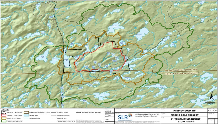
Source: Magino Gold Project Environmental Impact Statement, SLR Consulting
Figure 2 - Project, Local and Regional Study Areas – Air quality, noise and light study areas
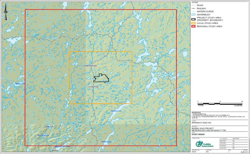
Source: Magino Gold Project Environmental Impact Statement, Golder Associates
1.2.6 Methods and approach
The Agency reviewed various sources of information to complete its analysis of potential adverse effects on each valued component outlined in Table 1.2, including:
- the environmental impact statement submitted by the proponent in July 2017;
- additional information provided by the proponent during the course of the environmental assessment in the form of responses to information requests from the Agency during its review of the environmental impact statement;
- advice from expert federal departments and provincial ministries; and
- comments received from the public and Indigenous groups.
The Agency assessed the significance of adverse effects on each valued component, following the application of mitigation measures, in accordance with the Agency's Operational Policy Statement: Determining Whether a Designated Project is Likely to Cause Significant Adverse Environmental Effects under CEAA 2012.[2] The Agency characterized the residual adverse effects on valued components by using the following assessment criteria:
- Magnitude: Severity of the adverse effect
- Geographic Extent: Spatial reach of the adverse effect
- Duration: Length of time a valued component would be affected by the adverse effect
- Timing: Applied to a valued component when relevant (e.g., species breeding season or fish spawning times, seasonality of Indigenous spiritual and cultural practices)
- Frequency: Rate of recurrence of the adverse effect
- Reversibility: Degree to which the environmental conditions can recover after the adverse effect occurs.
The Agency also considered context for all valued components and across all the criteria listed above. Context refers generally to the current state of the valued component and its sensitivity and resilience to the change caused by the Project.
The definitions and limits used to assign the level of effect for each rating criterion are presented in Appendix A (Table 1a and Table 1b). The Agency used the tables in Appendix A to help determine the significance of the effects which combines the degree (low, moderate or high) of the residual effect of each criterion. With the help of the tables, the Agency was able to make an overall assessment of the significance of the residual effect on each valued component. The degree of residual effect is determined by taking into consideration the mitigation measures proposed by the proponent and all measures considered necessary by the Agency (Appendix C).The Agency considers effects to be "not significant" where the residual effects after mitigation measures have been implemented are low or moderate in magnitude; localized in geographic extent; short-term in duration; reversible; and have a low impact on the ecological, socioeconomic, or cultural context.
The Agency considers effects to be "significant" where the residual effects after mitigation measures have been implemented would be high or moderate in magnitude; long-term; and would have either a moderate or high impact when considering the ecological, socioeconomic, or cultural context.
Appendix B summarizes the residual effects assessment for all valued components during all phases of the Project. The Agency's analysis and conclusions on the significance of adverse environmental effects are presented in Chapter 7.
2 Project Overview
2.1 Project Location
The Project is situated on a site that contains a past-producing underground gold mine, associated infrastructure, landfill, tailings facility and polishing pond. It is located in Finan Township, 14 kilometres south-east from the Town of Dubreuilville and 40 km northeast of Wawa, Ontario and north of Lake Superior. It is situated within the Robinson-Superior Treaty Area (see Figure 3:).
Figure 3 - Project Location
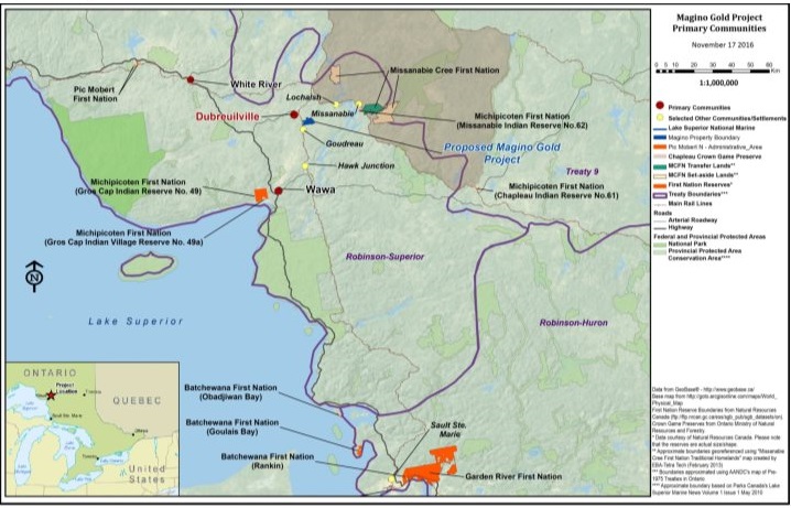
Source: Magino Gold Project Environmental Impact Statement
2.2 Project Components
The main project components are listed in Table 2.1. Figure 4: and Figure 6: illustrate the proposed geographic locations of the components.
| Component | Detail |
|---|---|
|
Open-pit |
The open-pit would be approximately 105 hectares and up to 430 metres deep. Webb Lake and a portion of an unnamed water body (Water Body 10) lie within the open-pit and would be drained. |
|
Water management system |
The water management system would include a system to supply fresh water from Goudreau Lake for ore processing and domestic use and a system for collecting and discharging mine water to Otto Lake. To prevent groundwater flows from Goudreau Lake into the open-pit, a slurry wall would be constructed, which would extend to the bedrock. Water that would infiltrate into the pit would be sent to the tailings management facility or used as process water as necessary using sump pumps and pipelines. Effluent from the processing plant, called tailings, would be pumped into the tailings management facility. An estimated 500 000 cubic meters of fresh water would be required during the start-up of the process plant and tailings management facility, which would be obtained from water that is impounded naturally within the tailing management facility area when initially constructed, from the historical tailings facility, and from Lovell and Webb Lakes, as they are to be drained during construction. The process plant would circulate approximately 25 000 cubic metres of water per day. The majority of the process water would be obtained through recirculation from the process plant, recycled from the tailing management facility, pumped from the pit, and from seepage collected from around the project facilities. A maximum monthly average of 1 840 cubic metres per day of fresh water would be pumped from Goudreau Lake for the ore processing facility and for potable use. Mine water would be managed using a series of ditches and subsurface trenches to collect water and direct it to the water quality control pond. Runoff would be collected in a lined collection ditch around the base of the mine rock management facility and a series of detention ponds. Seepage would be collected using a series of collection trenches beneath the surface of the tailings management facility. Sediment in water collected in the water quality control pond and detention ponds would be allowed to settle and water would be discharged once provincial water quality objectives and federal regulatory limits are met. The discharge would occur at Otto Lake, located in the northwest portion of the biophysical local study area. |
|
Tailings management facility |
The tailings management facility (390 hectares), including containment dams and dykes, a reclaim pond and a mine water collection system, would be located immediately northwest of the open-pit. The facility would store approximately 150 million tonnes of tailings, up to 80 metres thick. |
|
Mine rock management facility |
The mine rock management facility (approximately 360 hectares) would be immediately northwest of the open-pit and would surround the tailings management facility (Figure 6:). It would hold up to 430 million tonnes of mine rock and be up to 85 metres tall. The mine rock management facility would include a mine water collection system. |
|
Overburden stockpile |
Soils and overburden removed during construction would be stored in the overburden stockpiles located southwest and northwest of the mine rock management facilities. The total area covered by the stockpiles would be 60 hectares, holding up to 1.5 million cubic metres of topsoil and 16 million cubic metres of overburden. Some of the material may be used during decommissioning to rehabilitate the project footprint. The stockpile would have a mine water collection system. |
|
Ore stockpiles |
A 27 hectare area, approximately 10 metres tall, located directly east of the mine rock management facility, adjacent to the processing plant, where approximately 25 million tonnes of the 150 million tonnes of ore mined will be located. The approximately 25 million tonnes of ore will be processed from year 11 onward (the eighth year of operations). Another 40 hectare area, approximately 5 metres tall (labeled southeast fill area in Figure 4: and Figure 6:); located adjacent to the mine rock management facility, where 10 million tonnes of low-grade ore will be located. This stockpile would be created during the first four years of operations when more ore is mined than can be processed. The low-grade ore would be processed by the end of operations. |
|
Ore processing facility |
An ore processing facility and associated infrastructure would include a crusher, conveyor and effluent treatment plant. Ore from the ore stockpiles would be hauled to the ore processing facility and gold doré bars would be produced. Effluent would be treated in the effluent treatment plant to reduce the level of cyanide and water content prior to discharge to the tailings management facility. |
|
Linear infrastructure |
The existing Goudreau Road will be by-passed around the project footprint. The bypass road would be approximately 8.5 kilometres. A 44-kilovolt transmission line from Hawk Junction, managed by Algoma Power Inc., will provide power for the Project. The transmission line will follow the bypass road and terminate at a main substation on the Magino property. Back-up power will be supplied by diesel generators (see support an ancillary infrastructure below). |
|
Sewage treatment facility |
Sewage would be treated in a package sewage treatment plant, and treated prior to discharge into the tailings management facility in accordance with provincial requirements.[3] |
|
Solid waste disposal |
A burn pile would be constructed in proximity to the mine rock management facility where combustible waste wood, paper and cardboard would be burnt. The remaining solid waste (miscellaneous packaging materials, paper products, and organic waste) would be compacted and transported to the local landfill site in Dubreuilville. |
|
Support and ancillary infrastructure |
This would include the administration building, warehouse, maintenance facilities on-site back-up power supplied by three 1-megawatt diesel generators, and explosives storage. The proposed location of the explosive storage site is identified as the explosives magazine on Figure 4:. The locations of other structures would be selected within the project footprint, while optimizing project activities. |
|
Worker accommodation camp |
A temporary accommodation camp would be built, within the project footprint, to house a workforce of up to 400 persons during construction. Accommodations during operations would be located in a complex in Dubreuilville and some workers may reside in other local communities. |
|
Aggregate |
Aggregate used for the Project would be sourced entirely from the open-pit using only non-acid generating mine rock. |
Figure 4 - Project Components and Site Layout
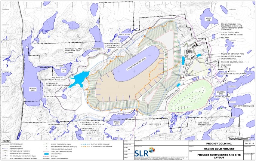
Source: Magino Gold Project Environmental Impact Statement, SLR Consulting
2.3 Project Activities
Key project activities that would occur during each project phase are listed in Table 2.2. The table also shows the expected duration of each project phase. The proponent has not identified a start date for the Project.
| Project Phase and Duration | Project Activities |
|---|---|
|
Construction (3 years) |
|
|
Operation (12-15 years) |
|
|
Decommissioning (approximately 3 years) |
|
|
Abandonment (approximately 50 years) |
|
3 Purpose of Project and Alternative Means
3.1 Purpose of Project
The purpose of the Project is to produce gold doré (alloy of gold and silver) bars for sale worldwide. The proponent anticipated the Project would contribute to economic development in northern Ontario, in particularly with Indigenous communities in the form of employment and business opportunities. Indigenous groups expressed an interest in employment and economic development opportunities for community members and businesses, along with an interest in sustainable development.
3.2 Alternative Means of Carrying Out the Project
CEAA 2012 requires that every environmental assessment of a designated project take into account the alternative means of carrying out the project that are technically and economically feasible, and consider the environmental effects of any such alternative means. The Agency's Operational Policy Statement Addressing "Purpose of" and "Alternative Means" under the Canadian Environmental Assessment Act, 2012[4](CEAA, 2013) sets out the general requirements and approach to address the alternative means of carrying out the designated project under CEAA 2012. The proponent assessed alternative means to carry out the Project for the following project components, and included an evaluation of the economic, technical, and environmental considerations:
3.2.1 Alternatives Assessment
Ore processing facility
The feasibility of on-site and off-site ore processing was assessed. Off-site processing would involve transporting ore by truck to other off-site gold mines or existing milling facilities within a reasonable haul distance (defined as a distance less than 150 km). An on-site processing plant was considered both economically and technically feasible because it would be within the proponent's ability to implement and would provide a reasonable rate of return in comparison to off-site processing. Further, local communities and Indigenous groups expressed interest in employment opportunities that would be available with an on-site processing plant.
It is for those reasons that on-site processing was chosen as the preferred alternative.
Four processing methods for separating the gold from the ore were considered:
- Non-cyanide processing methods;
- Heap leaching on a lined pad;
- Processing by milling and cyanide leaching using a cyanide destruction circuit; and
- Processing by milling and cyanide leaching using a cyanide destruction circuit, plus natural cyanide destruction.
Alternative 1 was dismissed due to reduced effectiveness in extracting gold, making it economically unfeasible. Alternative 2 was considered to have more potential for adverse environmental effects than Alternatives 3 and 4. Alternatives 3 and 4 were considered to have similar economic and environmental performances, with alternative 4 preferred due to the greater operational flexibility provided from the process, and would be more protective of human health due to a smaller requirement for chemical use.
Linear infrastructure (e.g.: access roads and transmission line)
Three alternatives to supply power for the Project were considered:
- On-site power generation using renewable power sources (specifically, wind turbines);
- On-site power generation using diesel power sources; and
- Off-site power generation and transmission to the mine site by an existing transmission line, combined with on-site diesel power generation.
The first two options were not viewed as economically and/or technically feasible. Off-site power supplied by an existing transmission line was the preferred alternative. This alternative would require the relocation of the existing transmission line. Three alternative routes were assessed: a north route, central route, and a south route. The north route was the preferred alternative as it would be constructed along a public road, rather than a new right-of-way, reducing disturbance of vegetation, wetlands and mammals and having lower potential effects to migratory birds, and species at risk. Potential changes to air quality from noise and emissions associated with the north route would be minimized by constructing both the bypass road and transmission lines simultaneously.
The Goudreau Road would need to be relocated to accommodate the Project. Two alternatives for relocation were assessed: to the west of the open-pit and to the west of the tailings management facility and mine rock management facility. The preferred alternative was to relocate the road to the west of the tailings management facility and mine rock management facility. This alternative was considered to have the lowest potential for environmental effects, as it would allow the co-location of the transmission line along the new road, and would divert traffic away from the project footprint.
Water supply
Five alternatives for the water supply for the Project were assessed:
- Exclusive use of water from the open-pit and recycling process water;
- New water supply from Goudreau Lake, combined with use of water from the open-pit and recycled process water;
- New water supply from Herman and Goudreau Lakes, combined with use of water from the open-pit and recycled process water;
- New water supply from the Magpie River, combined with use of water from the open-pit and recycled process water; and
- New water supply from groundwater wells combined with use of water from the open-pit and recycled process water.
Alternatives 1 and 5 were not considered technically feasible. The amount of water available from the open-pit and recycled process water would not be sufficient to meet mine operational requirements in alternative 1. Alternative 5 was not technically feasible because no there was no geologic formation present capable of yielding the necessary water to supply the Project, and the development of multiple groundwater wells off the project property was not considered within the proponent's ability to implement. Alternatives 3 and 4 were not considered economically feasible due to the costs associated with constructing additional pipelines and water intake structures. Alternative 2 was the preferred option. It was considered the only economically and technically feasible alternative as Goudreau Lake would provide sufficient water for the Project's needs, while minimizing the amount of additional infrastructure needed.
Worker accommodation camp
Three alternatives for worker accommodation were assessed:
- All accommodations would be from available housing in surrounding communities;
- Accommodations would be provided in the local communities and an accommodation complex on the Magino property; and
- Accommodations would be provided in the local communities and an off-site accommodation complex located in Dubreuilville.
Accommodation within an on-site accommodation complex (alternative 2) would carry lower financial costs, and would likely result in fewer environmental effects than other alternatives. However, an off-site accommodation complex within Dubreuilville (alternative 3) was retained as the preferred option because it was strongly supported by local residents.
Non-hazardous, non-mining solid waste disposal
Three alternatives for the disposal of non-hazardous, non-mining solid waste were assessed:
- The use of an on-site landfill;
- The use of an existing municipal landfill near Dubreuilville; and
- The export of waste to another jurisdiction (beyond the town of Dubreuilville).
Alternative 2 was the preferred option for the disposal of non-hazardous, non-mining solid waste because it was assessed to have the lowest potential for adverse environmental effects of the three alternatives as it would avoid effects associated with the construction of a new facility (Alternative 1), and require a shorter distance than alternative 3 for the transport of waste, reducing potential effects to the atmospheric environment, including from greenhouse gas emissions. The proponent has committed to working with the community of Dubreuilville and the Ontario Ministry of Natural Resources and Forestry to use the existing waste management facilities at Dubreuilville and expand them as necessary.
Tailings and mine rock management facilities
The proponent assessed a number of alternatives for the location of the tailings management facility, the mine rock management facility and the method for tailings deposition. The alternatives were assessed following the methodology outlined in Environment and Climate Change Canada's Guidelines for the Assessment of Alternatives for Mine Waste Disposal[5]. Ten different potential locations were assessed for the placement of the tailings management facility (see Figure 5:). The preferred alternative was site G, which scored highest for environmental, technical and economic factors. Site G allowed for the most compact project footprint, while allowing for the largest storage capacity and was considered to have the lowest potential for effects to water quality, terrestrial and atmospheric environments.
Figure 5 - Tailings Management Facility Alternative Site Locations
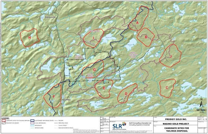
Source: Magino Gold Project Environmental Impact Statement, SLR Consulting.
Six alternatives for the disposal of tailings were assessed: disposal of tailings in the open-pit, dry stack tailings disposal, surface paste disposal, thickened tailings disposal, conventional tailings disposal and co-disposal of tailings and mine rock. Of these alternatives, only thickened and conventional tailings disposal were brought forward for detailed analysis due to technical and economic feasibility. The use of thickened tailings disposal was the preferred alternative selected by the proponent due to the environmental advantages over conventional tailings disposal, as it allows more water to be recycled for ore processing.
Alternatives to the location of the mine rock management facility were assessed, but there were no economically feasible alternatives to placing the mine rock management facility at the same site as the tailings management facility (site G in Figure 5:). The mine rock would be used to construct the tailings management facility embankment, and the rest stored in the area surrounding the tailings management facility (see Figure 4:).
Decommissioning of the tailings management facility
Two alternatives for the decommissioning of the tailing management facility were assessed:
- Creating a soil cover and a revegetated surface on the tailings management facility deck; and
- Creating a wetland and/or waterbody on surface of the tailings management facility deck.
Alternative 2 would reduce the potential for effects to dust from wind erosion from the tailings management facility, and would replace some of the lost wetland areas, which would provide some ecosystem services and habitats for wildlife. However, Alternative 1 was the preferred alternative because it was considered to reduce the potential for adverse environmental effects by providing greater long-term carbon sequestration, offering greater potential to replace lost habitats most likely to be used by wildlife, provides greater seepage prevention, and is more likely to be more attractive to a variety of land users, including Indigenous users.
Decommissioning of the open-pit
Three alternatives for the decommissioning of the open-pit were assessed:
- Pit filling from runoff and groundwater inflow;
- Pit filling from runoff and groundwater inflow, plus backfilling of the pit with mine rock and tailings; and
- Pit filling from runoff and groundwater inflow, plus from the operations water supply source.
Alternative 3 was preferred because it was considered to have lower potential for adverse environmental effects. Alternative 3 would provide for a water cover over the exposed pit walls in a shorter period of time and would be more protective of surface water quality in Goudreau Lake. Alternative 3 would return the environment to a natural state in a shorter period of time, reducing effects to the current use of lands and resources for traditional purposes.
Views expressed
According to the proponent, in relation to the location of the tailings management, Indigenous groups, including Batchewana First Nation, Missanabie Cree First Nation, Michipicoten First Nation and the Métis Nation of Ontario identified areas of traditional land use and cultural practices that could be potentially affected by the construction of the tailings management facility at locations A, G, I, and J. For example, site I was identified by the Métis Nation of Ontario as a large game harvesting area, Missanabie Cree First Nation identified that Site J lies within their current land use area, and Michipicoten First Nation identified a trail currently and historically used by members located just south of Site I. The proponent considered all of the information provided by Indigenous groups in selecting the preferred site of the tailings facility.
Agency Analysis and Conclusions
The proponent's alternatives assessment considered the cost-effectiveness, technical applicability, reliability, environmental effects, and feedback from Indigenous groups on the selected alternative means of carrying out the Project. Based on its review of this analysis, the Agency is satisfied that the proponent has sufficiently assessed alternative means of carrying out the Project for the purposes of assessing the environmental effects of the Project under CEAA 2012.
4 Consultation Activities and Advice Received
Comments from Indigenous group and public participants during the environmental assessment were considered by the Agency in its analysis conclusions regarding the Project. Local and traditional knowledge about the Project location was also considered in identifying potential environmental effects.
Advice received from federal authorities and key information shared between the Agency and the province of Ontario further informed and supported the Agency's review of the Project. As the Agency and the province of Ontario conducted the federal and provincial environmental assessments cooperatively, to the extent possible, the governments also held joint meetings with some Indigenous groups and shared key information received from public and Indigenous participants throughout the concurrent processes.
The Agency provided three previous opportunities for the public, Indigenous groups, and government reviewers to participate in the environmental assessment process. Notices of these opportunities to participate were posted on the Canadian Environmental Assessment Registry's Internet site. During these opportunities, comments were solicited on:
- whether an environmental assessment is required (July 19 to August 8, 2013),
- the draft environmental impact statement guidelines (September 3 to October 3, 2013), and
- the proponent's environmental impact statement (July 11 to August 21, 2017).
A fourth and final opportunity commenced on November 1, 2018 and the Agency is seeking comments on this report and potential conditions to support the Minister's decision statement. This report includes the Agency's conclusions and recommendations. After taking into consideration the comments received from the public, Indigenous groups and government reviewers, the Agency will finalize and submit the environmental assessment report to the federal Minister of Environment and Climate Change to consider when issuing the environmental assessment decision statement under the Canadian Environmental Assessment Act, 2012 (CEAA 2012).
4.1 Public Participation
4.1.1 Public participation led by the Agency
During the environmental impact statement review period, the Agency participated in public open houses with the proponent. These public open houses were held in Dubreuilville and Wawa on July 19, 2017 and in White River on July 20, 2017. These sessions provided opportunities for members of the public to learn and provide comments about the environmental assessment process, the Project and the proponent's environmental impact statement. Public members and organizations that provided comments to the Agency included: Northwatch Coalition for Environmental Protection, the communities of Dubreuilville, Wawa and White River, and local residents with an interest in the Project.
The Agency supported public participation in the environmental assessment through its Participant Funding Program. A total of $20,429.20 was allocated to the following groups: Corporation du développement économique et communautaire de Dubreuilville, and Northwatch Coalition for Environmental Protection.
The Agency received letters of support for the Project from the Corporation du développement économique et communautaire de Dubreuilville and the Economic Development Corporation of Wawa. Northwatch Coalition for Environmental Protection raised issues related to: water quality, groundwater quantity, the disposal of mine rock, cumulative effects, and the decommissioning and abandonment of the Project.
4.1.2 Public participation activities organized by the proponent
The proponent held a number of public open houses and information sessions in the communities of Dubreuilville, Wawa and White River from 2012 to 2016. The proponent also identified nearby property owners and individuals with land tenure (i.e.; holders of trapping and bait harvesting licenses, and bear management unit operators). The proponent consulted these individuals on the Project, its potential effects and possible mitigation measures. In addition, a number of interviews and meetings have been conducted with regional organizations, businesses, municipalities and other interested parties. Public outreach and communication were carried out using public radio, local newspapers, community newsletters, and by mail.
4.2 Crown Consultation with Indigenous Groups
4.2.1 Crown consultation led by the Agency
The Crown has a duty to consult Indigenous groups, and, where appropriate, to accommodate, when its proposed conduct might adversely impact Aboriginal and Treaty rights protected in section 35 of the Constitution Act, 1982[6]. Crown consultation is also undertaken more broadly as an important part of good governance, sound policy development and appropriate decision making.
For the purposes of the federal environmental assessment, the Agency served as Crown Consultation Coordinator to facilitate a whole-of-government approach to consultation. Indigenous groups that were invited to participate in consultations included those identified as having an interest in the project by reason of the potential for the Project to adversely impact Aboriginal and Treaty rights. Batchewana First Nation was engaged in the environmental assessment process in 2014 after the comment period on the environmental impact statement Guidelines, and Garden River First Nation become actively involved in the environmental assessment process in 2017, and was allocated funding in July 2017. Neither provided comment on the project description or environmental impact statement Guidelines.
In order to fulfill the Crown consultation obligations, the Agency conducted Indigenous consultation in an integrated manner with the environmental assessment process. The Agency provided opportunities throughout the environmental assessment for dialogue with Indigenous groups about their concerns through phone calls, correspondence, and meetings. The Agency provided regular updates to the Indigenous groups to keep them informed of key developments and to solicit feedback. In addition, the groups were invited to participate in the four formal consultation opportunities noted above. The results of that analysis are set out in sections 7.3 and 7.4 of this report. The potential impacts on asserted or established Aboriginal and treaty rights are discussed in section 9.0.
The Agency administers funding from its Participant Funding Program to support Indigenous groups to participate in the environmental assessment process. Funds were provided to reimburse eligible expenses of Indigenous groups that participated in the environmental assessment. A total of $272,851.24 was allocated to the Indigenous groups listed below.
| Indigenous group | Amount allocated |
|---|---|
|
Batchewana First Nation |
$35 000 |
|
Garden River First Nation |
$34 300 |
|
Michipicoten First Nation |
$43 250 |
|
Missanabie Cree First Nation |
$37 500 |
|
Pic Mobert First Nation |
$42 051.24 |
|
Red Sky Métis Independent Nation |
$43 250 |
|
The Métis Nation of Ontario |
$37 500 |
The Agency met with Michipicoten First Nation, Missanabie Cree First Nation, Batchewana First Nation, Garden River First Nation, Pic Mobert First Nation and Red Sky Métis Independent Nation between July 11, 2018 and July 20, 2018 to discuss the Project, introduce the proponent's environmental impact statement, and invite any comments and questions. The Métis Nation of Ontario declined to meet during this period, but suggested that once its review of the EIS was complete, they would communicate their desire to meet with the Agency to discuss any concerns.
The Agency first contacted Garden River First Nation about the Project in February 2015 following information received from the proponent. However, as noted above, the community became actively involved in 2017. The Agency met with the community several times, including in the community in July 2017. The Agency met with Garden River First Nation again in April 2018 about outstanding concerns related to the Project's potential impacts on Indigenous use and rights, and the proponent's engagement. The Agency provided clarification to both the proponent and Garden River First Nation on the requirements for engagement and gathering of information to inform the effects assessment. The proponent provided funding to Garden River First Nation to undertake a traditional land use study to help further understand the potential impacts of the Project on the First Nation.
The key issues raised during the consultation were linked to:
- Effects of the projects to hunting and fishing areas;
- Degradation of water quality in the surrounding waterbodies and the effects this may have on fisheries downstream from the Project;
- The ability of the proponent to offset effects to fish and fish habitat and restore lost wildlife habitat including wetlands after decommissioning;
- Effects to Species at Risk; and
- The potential impacts of the Project on Aboriginal or treaty rights.
With the exception of Pic Mobert First Nation and Garden River First Nation, the proponent has signed or is in the processing of completing agreements with all of the groups involved in the environmental assessment. Red Sky Métis Independent Nation sent a letter to the Agency expressing support for the Project and faith that the proponent has mitigated any potential adverse effects of the Project on their traditional activities and impacts on Aboriginal and treaty rights. The Métis Nation of Ontario sent a letter to the Agency expressing its faith in the proponent's ongoing efforts to engage with them and confidence that all their concerns relating to the Project would be addressed prior to this draft report being submitted for comment. Missanabie Cree First Nation sent a letter to the Agency confirming that they have a productive relationship with the proponent and that the community is supportive of the Agency issuing a positive environmental assessment decision. No views have been provided by the other Indigenous groups to date.
Comments received by the Agency were responded to directly or provided to the proponent to respond to and a summary of issues is found in Appendix D.
4.2.2 Engagement with Indigenous groups and engagement activities organized by the proponent
The proponent engaged frequently with the identified Indigenous groups between 2012 and 2018 using a variety of means, including presentations and meetings with the community and leadership or consultation committees, staff and consultants, through correspondence and telephone calls. The proponent offered financial support for conducting traditional land use studies and reviewing key environmental assessment and regulatory documents, including funding for a third-party expert review of the environmental impact statement which supported Batchewana First Nation. The proponent met with Michipicoten First Nation, Missanabie Cree First Nation, Batchewana First Nation, Red Sky Métis Independent Nation and the Métis Nation of Ontario to provide overviews of the Project as it evolved throughout the environmental assessment and to discuss issues.
The proponent was not successful in engaging with Pic Mobert First Nation due to the First Nation's decision not to actively participate in the environmental assessment. The proponent has kept Pic Mobert First Nation informed about the Project and key milestones and documentation released throughout the environmental assessment. As noted in Section 4.2.1, Garden River First Nation became actively involved in the environmental assessment of the Project just prior to the Agency's review of the environmental impact statement in 2017 and was engaged by the proponent on the Project and its potential effects.
4.3 Participation of Federal and Other Experts
In accordance with section 20 of CEAA 2012, federal authorities in possession of specialist or expert information or knowledge with respect to the Project provided advice to the Agency on whether an environmental assessment was required. Federal authorities also participated in the review of the draft environmental impact statement guidelines and the proponent's environmental impact statement, and provided input into the preparation of this report and potential conditions to support the Minister's decision statement. The following federal authorities provided advice:
- Fisheries and Oceans Canada: input on fish and fish habitat that are part of, or support, a commercial, recreational or Aboriginal fishery and provisions related to fish passage and flow.
- Environment and Climate Change Canada: input on air quality, method and location of mine waste disposal, effluent discharges related to mine waste management, surface water quality and quantity, non-aquatic species at risk, migratory birds, climate change, and accidents and malfunctions.
- Natural Resources Canada: input on hydrogeology, geochemistry (metal leaching and acid rock drainage), mining and mineral environmental science, explosives manufacture and storage.
- Health Canada: input on potential impacts on Indigenous health related to country foods, water quality, noise levels and air quality.
- Transport Canada: input on impacts to navigable waters and potential impacts on Indigenous use related to the loss of navigable water bodies.
A coordinated environmental assessment was not required for the Project. However, the following provincial ministries provided support upon request on areas within their expertise and within the scope of their regulatory roles: the Ministry of Natural Resources and Forestry, Ministry of Environment, Conservation and Parks, Ministry of Tourism, Culture and Sport, and the Ministry of Energy, Northern Development and Mines.
5 Geographical Setting
5.1 Biophysical Environment
The Project is located within the Wawa geological subprovince of the Canadian Shield, in the Lake Abitibi ecoregion, within the Lake Superior watershed. More specifically, the Project is located within the Magpie-Michipicoten River Basin situated east of Lake Superior in northern Ontario. Surface flows draining north of the divide drain to the Magpie River catchment, and surface flows draining south of the divide drain to the Michipicoten River catchment. Both catchments ultimately drain to Lake Superior. The local study area is comprised of three subwatersheds:
- Herman-Otto watershed, including Mountain Lake, Herman Lake and Otto Lake;
- Spring-Lovell watershed, including Spring Lake, Lovell Lake and McVeigh Creek; and
- Webb-Goudreau watershed, including Webb Lake and Goudreau Lake.
McVeigh Creek and Goudreau Lake are the largest watercourse and waterbody, located in the central and eastern portions of the local study area, respectively. Surface water quality varies by lake and watercourse, with a few parameters, typically metals, exceeding applicable provincial or federal guideline values. Stream and lake sediment have occasional concentrations above provincial guideline values for: arsenic, iron, manganese, zinc, nickel and copper. This can be explained by the metal-rich nature of the bedrock and historic mining activities.
The groundwater quality is considered of good quality and classified as "hard", while surface water in the Project Study Area contained low levels of metals, with occasional exceedances of Canadian and provincial water quality guidelines and objectives for cadmium, cobalt, copper, iron, total mercury, methyl mercury, tungsten, silver and zinc. Among all metals measured, concentrations of iron exceeded guidelines and objectives most frequently and by greater orders of magnitude than other metals.
The geographic area is characterized by low ridges and hills flanked by flat areas, with mixed and coniferous forest and numerous streams, lakes, wetland complexes and connecting watercourses. The regional climate is considered humid continental, characterized by warm to hot summers and cold winters. The mean annual precipitation is 949 millimetres, with approximately 30 percent falling as snow.
The upland forests, wetlands, and waterbodies in the regional study area provide suitable habitat for migratory birds, species at risk, and potentially 48 mammal species. All potentially occurring mammal species are year-round residents to the regional study area. A total of 10 potentially occurring mammals were detected during proponent field programs. Beaver, moose and black bear were most commonly detected. Marten, fox, wolf, lynx, and star-nosed mole were the least detected mammals. A large number of snowshoe hares were observed incidentally along the roads and trails. Other species known to be present but not observed during field studies include mink, muskrat, otter, and fisher.
Air quality in the regional study area likely falls within normal values compared to national averages. Noise levels are dominated by sounds of nature and human activity typical of a rural setting. Transportation corridors, such as Highway 519, secondary roads, logging roads and rail lines that traverse the area are the dominant local sources of air quality changes and noise. In addition, air quality and noise conditions in the immediate vicinity of the Project are affected by the nearby Island Gold Mine.
5.2 Human Environment
The Project is located within the Unorganized Area of Finan Township, on the site of a historic underground gold mine, which has been mined by multiple companies from 1925 until the present day. It is located on provincial Crown land and is governed by the Ontario provincial land use policy. Mining remains the area's largest employment sector. There are currently three active gold mines operating in the Wawa, Dubreuilville and White River areas: the Island Gold Mine (operated by Alamos Gold, formerly Richmont Mines Inc.), Eagle River Mine (Wesdome Gold Mines) and the Hemlo mines (Barrick Gold Corporation, the David Bell and Williams mines operate on the same property). The adjacent Island Gold Mine is located in the local study area.
The nearest communities are Dubreuilville, White River and Wawa, with populations of 613, 645 and 2 905, respectively (Statistics Canada, 2016). The area around Dubreuilville has been prospected and mined since the early 1900s. The Project is located in an area used today by the public for recreational fishing, hunting, boating, and commercial activities including tourism, outfitting, trapping, and bait harvesting. For example, Herman and Goudreau Lakes are popular for fishing, and snowmobile trails exist along the Goudreau road. There are approximately 10 to 15 cabins or structures that are used on a seasonal basis for recreational purposes in the former Township of Goudreau, in the local study area directly southwest of the project study area and two more on Herman and Goudreau Lakes.
Indigenous groups consulted on the project conduct traditional activities in the vicinity of the Project, including hunting, fishing and plant gathering. The Indigenous groups nearest to the Project are Michipicoten First Nation, Missanabie Cree First Nation, and Pic Mobert First Nation. However members and citizens of other Indigenous groups, including Red Sky Metis Independent Nation, the Metis Nation of Ontario, Batchewana First Nation and Garden River First Nation live in nearby communities.
6 Predicted Changes to the Environment
6.1 Atmospheric Environment
The Project could cause residual effects on the atmospheric environment through:
- increase in ambient air concentrations of total suspended particulate, particulate matter (PM10), fine particulate matter (PM2.5), nitrogen dioxide, sulphur dioxide, carbon monoxide and metals, extending into the local study area;
- increase in ambient noise levels into the local study area; and
- increase in vibrations from blasting activities in Goudreau Lake.
The Agency's summary of the proponent's assessment on the changes to the atmospheric environment considered the views expressed by federal departments, provincial ministries and Indigenous groups. The Agency used this summary in its analysis of effects to fish and fish habitat, Indigenous uses, and human health in Chapter 7 of this report, including the mitigation and follow up measures noted in Sections 7.1, 7.3 and 7.4.
Description of the Existing Environment
Existing concentrations of total particulate matter (including PM10 and PM2.5), nitrogen dioxide, sulphur dioxide, carbon monoxide and metals are below applicable federal standards.[7]
Existing noise levels, averaged at two monitoring locations near the Project, were found to be below the provincial standards.[8] Existing vibration levels were not measured, as no existing sources of vibration were identified in or near Goudreau Lake.
6.1.1 Air Quality
Proponent's assessment of environmental effects, mitigation and monitoring
Air emissions would be higher during operations than during construction and decommissioning, and therefore changes to air quality were modelled based on activities during operations. Modelling was conservative, for instance, simultaneous maximum ore extraction, maximum mine rock extraction and maximum ore processing rates, haul trucks always travel the maximum distance to transport materials from the bottom of the open-pit to the stockpiles.
Emissions of dust (particulate matter) and metals during operations would result from material handling and transport, ore processing (dropping, crushing and smelting), onsite ore and waste rock management, and blasting in the open-pit. Blasting would also cause emissions of nitrogen oxides (including nitrogen dioxide) and carbon monoxide. Activities related to ore refining that involve cyanidation would emit sulphur dioxide, which is used to destroy the cyanide.
The Project would result in exceedances of federal standards[7] within parts of the local study area for 24-hour average concentrations of total suspended particulate, PM10, and PM2.5, and for 1-hour average concentrations of nitrogen dioxide and cadmium. These exceedances would occur to the east and south of the project boundary, across from the open-pit and process plant. Exceedances would occur around 12 days per year for total suspended particulate, around six days per year for PM2.5, less than 88 hours per year for nitrogen dioxide, and less than 44 hours per year for cadmium, and would mostly occur in the winter when winds are calm. Exceedances of PM10 would occur up to 83 days per year, most likely in the winter but possibly in all four seasons, when winds are calm. The proponent also anticipated increases, without exceeding federal standards, in annual average concentrations of total suspended particulate (including diesel particulate matter), PM2.5 and sulphur dioxide, 24-hour average concentrations of nitrogen dioxide and sulphur dioxide, and 1-hour average concentrations of sulphur dioxide and carbon monoxide, all in the local and regional study areas. Metals in particulate matter would increase in proportion to the increase in particulate matter concentrations, without exceeding federal standards. A discussion of how changes to air quality could affect human health (Section 7.4) and Indigenous uses (Section 7.3) follows.
The proponent has proposed several measures to reduce the effects of the Project on air quality. Those measures are listed in the document titled "Addendum to the Environmental Impact Statement - Mitigation, Monitoring and Commitment List" available on the Canadian Environmental Assessment Agency Registry Internet Site, and include:
- Use of enclosures and fugitive emissions dust control with baghouses for dry material handling or processing activities.
- Develop operation and maintenance manuals for all pollution control equipment, and implement a preventative maintenance program to keep equipment operating to design specifications.
- Develop mine rock stockpiles in stages, to be progressively closed off to minimize exposed surfaces to wind erosion.
- Ensure that non-road vehicles meet Canadian Tier 4 off-road diesel emission standards in Canada.
- Manage exhaust emissions from non-road vehicles through regular and routine maintenance of vehicles.
- Use diesel fuel with less than 15 parts per million of sulphur, to reduce sulphur dioxide emissions from non-road vehicles and stationary equipment.
Views expressed
Batchewana First Nation raised concerns about the assumptions used in the air quality assessment, particularly about the absence of wind erosion from tailings in the model. The proponent noted that wind erosion would only occur as short-term events during high winds, and would not affect average 24-hour concentrations.
Batchewana First Nation and Health Canada noted that emissions related to vehicles travelling to and from the Project, or used for transportation of processed supplies off-site, were not considered in the air quality and noise assessment despite the traffic likely increasing due to the Project. The proponent provided an off-site traffic assessment for Goudreau Road and the proposed public bypass road, noting that inclusion of this traffic would not change conclusions drawn from the air quality or noise assessments.
6.1.2 Noise and Vibration
Proponent's assessment of environmental effects, mitigation and monitoring
Noise and vibration levels would be higher during operations than during construction and decommissioning due to blasting in the open-pit and the full operation of all project components. Therefore, changes to noise and vibration levels were modelled for the operations phase using conservative assumptions about mining activities at the open-pit and at the process plant. The model assumed continuous operations 24 hours per day, 7 day per week thus eliminating any distinction between daytime and nighttime noise levels. Additional assumptions included continuous use of the most active surface and pit equipment; a shallow open-pit depth to maximize noise propagation; the maximum ore processing rate; and noise levels inside all buildings at 85 decibels.
Noise emissions during operations would result from onsite haulage of materials; stockpiling of low-grade ore, mine rock, topsoil and overburden; operations at the ore processing plant and other facilities; mining waste management, including the mine rock waste management facility and the tailings management facility; and activities related to progressive rehabilitation of the mining waste management facilities. Blasting in the open-pit would cause both noise and vibration.
Exceedances of the provincial standards[9] were predicted in areas to the east and south of the project study area. Exceedances of daytime limits could occur up to approximately 1.2 km into the local study area, to the south of the project study area in the vicinity of the open-pit, while exceedances of nighttime limits could occur up to approximately 2.5 km away, to the east and south of the project study area in the vicinity of the open-pit and process plant. Noise levels at points of reception (cottages, cabins and cemetery), within the local study area to the west of the open-pit and process plant, were predicted to increase while remaining within provincial standards. Noise levels from blasting were predicted to remain within provincial standards[10] within the local study area, including these points of reception. Noise levels of blasts could exceed 100 decibels within 3 kilometres of the open-pit, and could exceed 90 decibels within 9.2 kilometres of the open-pit, which would be into the local study area. A discussion of how changes to noise levels could affect migratory birds and the current use of lands and resources for traditional purposes is found in Section 7.2 and Section 7.3, respectively.
The proponent predicted that Fisheries and Oceans Canada guidelines for ground vibrations (peak particle velocity of 13 millimetres per second in a spawning bed during egg incubation) could be exceeded when blasting occurred at less than 399 metres from the Goudreau Lake shoreline, and that Fisheries and Oceans Canada guidelines for underground overpressure levels (100 kilopascals) could be exceeded when blasting occurred at less than 136 metres from the Goudreau Lake shoreline. Vibration levels at points of reception (cottages, cabins and cemetery) identified by the proponent were predicted to remain within Ontario Ministry of Environment, Conservation and Parks peak particle velocity limits of 12.5 millimetres per second (NPC-119) in all cases. A discussion of how changes to vibration could affect fish (Section 7.1) follows.
The proponent has proposed several measures to reduce the effects of the Project on noise and vibration levels. Those measures are listed in are listed in the document titled "Addendum to the Environmental Impact Statement - Mitigation, Monitoring and Commitment List" available on the Canadian Environmental Assessment Agency Registry Internet Site, and include:
- Locate the process plant inside a building with indoor noise levels less than 85 decibels.
- Design building dimensions, layout and orientation to provide shielding for process equipment that produce noise.
- Equip onsite vehicles and equipment with original noise control measures (e.g., mufflers), and maintain in good working order.
Views expressed
Federal Authorities
Health Canada indicated that the noise model does not account for traffic on the Bypass Road. The proponent noted that traffic will be minimal during operations.
Indigenous Groups
Batchewana First Nation asked for the proponent to commit to develop a detailed monitoring plan and seek stakeholder input for the plan. The proponent committed to form an "Environmental Monitoring Committee" with Indigenous groups, to review mitigation and monitoring plans, and monitoring result.
6.2 Water Resources
The Project could cause residual effects on water resources through:
- Changes in water levels and flows in Goudreau Lake;
- Changes in water levels and flows in Spring Lake and McVeigh Creek;
- Changes in water quality of Otto Lake; and
- Changes in sediment quality of Otto and Herman Lakes.
With input from federal departments, provincial ministries and Indigenous groups, the Agency has summarized the proponent's assessment on the changes to the water resources. This summary supports the analysis of fish and fish habitat (Section 7.1), human health (Section 7.4) and Indigenous use (Section 7.3) of this report, including the mitigation and follow up measures.
Existing Environment
Goudreau Lake is the largest lake (165 hectares) within the Webb-Goudreau subwatershed and is located in the southeast portion of the local study area (Figure 1: and Figure 6:). The lake is long and narrow and comprised of two arms; one extending north and the other extending south and bending towards the east. It is one of the deepest lakes (a maximum depth of 23 metres in the northern arm) in the local study area. Goudreau Lake receives its surface water flow from Webb Lake, and groundwater flow from the northwest, where the tailings management facility is proposed.
Spring Lake and McVeigh Creek are part of the Spring-Lovell subwatershed, and located to the north of the Webb-Goudreau subwatershed. The watershed contains a total of nine waterbodies, including Lovell Lake, Waterbodies 1 to 5, and the historical tailings and polishing ponds. Spring Lake is located at the downstream end of the watershed, and has a maximum depth of approximately 3.5 metres. Spring Lake is fed by Lovell Lake to the northeast and Waterbody 3 to the north and drains west to McVeigh Creek. Groundwater feeds this subwatershed from the central portion of the project study area, and is most pronounced in Lovell Lake in the southeast, and Spring Lake and McVeigh Creek in the southwest.
Otto and Herman Lakes are part of the Herman-Otto subwatershed and located on the western side of the local study area. This watershed includes Otto Lake, which is a small and shallow lake (13.7 hectares with an average depth of 1.3 metres). Sediment quality sampling showed background levels of phosphorus in Otto Lake, and copper in both Otto and Herman Lakes exceeded provincial standards.[11]
Figure 6: - Surface water features associated with the Magino Gold Project
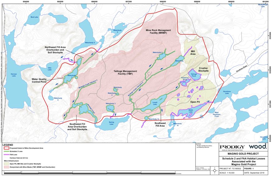
Source: Magino Gold Project Environmental Impact Statement, Wood plc.
6.2.1 Changes in water levels and flows in Goudreau Lake
Proponent's assessment of environmental effects, mitigation and monitoring
Changes in water levels and flows are predicted in Goudreau Lake due to project activities, including water withdrawal from Goudreau Lake during operations, decommissioning and abandonment, groundwater changes within the zone of influence [12] of the open-pit during operations and dewatering of Webb Lake during construction.
Fresh water requirements from Goudreau Lake during operations, decommissioning and abandonment are described in detail in Table 2.1, Section 2.1, and would require a maximum monthly average of 1840 cubic metres per day, during peak operating years (years 11 and 12), for the ore processing facility and potable use to supplement water recycled from the Project. This would result in a decrease in water levels but would remain within natural variation. Measures to mitigate impacts to fish are further described in Section 7.1.
As the open-pit becomes progressively deeper over a span of ten years, the groundwater zone of influence would increase and cause more groundwater to flow to the open-pit. Groundwater modelling predicted that this zone of influence could cause groundwater levels to drop by as much as one metre up to a distance of 1 300 metres from the rim of the pit. Since Goudreau Lake lies within this zone of influence, it would also experience a reduction in water levels and flows. A groundwater flow barrier would be installed between the open-pit and Goudreau Lake to minimize flows into the open-pit. Any water infiltration into the open-pit would be collected and used for the process plant, or treated and discharged into Otto Lake.
Webb Lake would be dewatered during construction as it is within the footprint of the open-pit. Waterbody 10, which drains into Webb Lake (Figure 6:), would be partially overprinted by the open-pit and the remaining portion would be lost due to the open-pit zone of influence (Table 6.1). The loss of these fish-bearing waterbodies would be mitigated as described in Section 7.1. Draining of water from Webb Lake and Waterbody 10 into Goudreau Lake would result in a temporary increase in water levels and flows for the first two months, which is expected to be within natural variation. Afterward, the loss of Webb Lake would decrease the amount of water that drains into Goudreau Lake by one percent.
During operations, the combined effects on Goudreau Lake water levels result in a decrease in water level by up to 2.1 cm during average precipitation conditions, but this change remains within natural variation. The worst-case scenario was modeled, which assessed a one-year extreme drought condition in Year 12 of operations when the volume of water pumped from Goudreau Lake for the processing plant would be highest. The results revealed that under this scenario, Goudreau Lake would experience a 4.2 centimetre decrease in water levels, which would be below natural variation. However, this would be of short duration and water levels and flows would return to baseline conditions when the drought conditions cease.
Views Expressed
Indigenous groups
Batchewana First Nation inquired about the changes in water levels and flows from freshwater withdrawal in Goudreau Lake, and the corresponding effects on fish and fish habitat. The proponent's assessment indicated that the changes in water levels and flows will remain within natural variation. The proponent committed to minimizing the freshwater withdrawal from Goudreau Lake by recycling the water collected in the water quality control pond.
6.2.2 Changes in water levels and flows in Spring Lake and McVeigh Creek
Proponent's assessment of environmental effects, mitigation and monitoring
A decrease in water levels and flows was predicted in Spring Lake and McVeigh Creek due to the loss of upstream waterbodies from the construction of project infrastructure, draining of Lovell Lake during construction and the excavation of the open-pit during operations.
The development of the tailings management facility, mine rock management facility, open-pit and process plant area during construction would result in a loss of waterbodies and streams that drain into Spring Lake and McVeigh Creek (Figure 6: and Table 6.1). Lovell Lake, which is within the proposed footprint of the mine rock management facility, would be dewatered into Spring Lake and removed as part of the open-pit construction. Diversion ditches would be constructed around the perimeter of Lovell Lake to maintain water flow downstream to Spring Lake and McVeigh Creek. The loss of fish-bearing waterbodies (Table 6.1) would be mitigated as described in Section 7.1.
Draining of Lovell Lake would cause an increase in water levels of Spring Lake and flows in McVeigh Creek outside of the range of natural variation for a period of two months. Once Lovell Lake is fully drained, the water levels in Spring Lake and flows in McVeigh Creek would return to baseline conditions.
As discussed in Section 6.2.1, the excavation of the open-pit would create a groundwater zone of influence, which would affect Spring Lake and McVeigh Creek. As a result, both waterbodies would also experience a reduction in groundwater inflow. The maximum change would occur during operations; in which water levels in Spring Lake would drop 9.35 centimetres and flow in McVeigh Creek would decrease by 66 and 34 percent at the boundaries of the local and regional study areas, respectively. These changes in flow in McVeigh Creek, which are outside of natural variation, would cause effects on fish and fish habitat, which are discussed in section 7.1.
| Project infrastructure | Waterbody | Area (hectares) |
|---|---|---|
|
Open-pit |
Webb Lake |
10.5 |
|
Waterbody 10 |
5.7 |
|
|
Mine rock management facility |
Lovell Lake |
12.6 |
|
Waterbody 13 |
0.6 |
|
|
Waterbody 1 |
3.8 |
|
|
Tailings management facility |
Waterbody 2 |
2.3 |
|
Waterbody 3 |
2.9 |
|
|
Waterbody 4 |
0.2 |
|
|
Waterbody 5 |
0.5 |
|
|
Waterbody 12 |
0.1 |
|
|
McVeigh Creek (downstream of Spring Lake) |
8.3 |
|
|
McVeigh Creek tributaries |
0.8 a |
|
|
Process plant area |
Polishing Pond |
1.9 |
|
Water Quality Control Pond |
Waterbody 7 |
9.0 |
|
a:area lost due to flow alterations in McVeigh Creek |
||
Views Expressed
Indigenous groups
Batchewana First Nation noted that although water from Webb and Lovell Lakes would be drained into Goudreau and Spring Lakes, respectively, there was no indication of where the water from the other overprinted waterbodies would be discharged. The proponent responded that the water drained from the other waterbodies would be pumped into the tailings management facility for use as process water. If the tailings management facility is not constructed sufficiently to store water, the non-mine water would be directed to adjacent waterbodies, or to temporary water management facilities.
6.2.3 Changes in water quality of Otto Lake and Herman Lake
Proponent's assessment of environmental effects, mitigation and monitoring
The water quality of Otto and Herman Lakes would change due to the discharge of mine effluent in Otto Lake during operations. However, effluent would meet the requirements set out in the Metal and Diamond Mining Effluent Regulations.
Maximum concentrations of sulphate, total phosphorus, copper, mercury, ammonia, and silver in the effluent would be above the selected water quality guidelines (Table 6.2) at discharge. With the exception of copper, all parameters would stay below acute toxicity levels. However, once effluent is discharged and mixed into the water body, the maximum concentrations of copper in Otto Lake after discharge would remain below the acute toxicity threshold (Table 6.2).
Sulphate concentration would meet applicable water quality guidelines [13] in Otto Lake within 414 metres from the point of discharge, and total phosphorus, copper, mercury and silver concentrations would meet applicable water quality guidelines in the eastern arm of Herman Lake, downstream of Otto Lake.
| Parameter[1] | Background | Predicted maximum effluent concentration | Predicted maximum lake concentration[2] | Selected Guideline[3] | Acute toxicity concentration[4] |
|---|---|---|---|---|---|
|
Otto Lake |
|||||
|
Mercury |
0.0000100 |
0.0000793 |
0.0000334 |
0.0000260 |
0.000240 |
|
Total Phosphorus |
0.0125 |
0.0838 |
0.0416 |
0.0200 |
- |
|
Sulphate |
4.01 |
844 |
354 |
218 |
889 |
|
Copper |
0.00100 |
0.0683 |
0.0280 |
0.00998 |
0.0295 |
|
Silver |
<0.00010 |
0.00111 |
0.000493 |
0.000250 |
0.00410 |
|
Ammonia |
0.0210 |
1.6 |
0.901 |
0.588 [3] |
- |
|
Herman Lake |
|||||
|
Mercury |
0.0000100 |
0.0000793 |
0.0000195 |
0.0000260 |
0.000240 |
|
Total Phosphorus |
0.0160 |
0.0838 |
0.0195 |
0.0200 |
- |
|
Sulphate |
4.095 |
844 |
143 |
309 |
889 |
|
Copper |
0.00100 |
0.0683 |
0.0108 |
0.0229 |
0.0295 |
|
Silver |
<0.00010 |
0.00111 |
0.000197 |
0.000250 |
0.00410 |
|
Ammonia |
0.0425 |
1.6 |
0.428 |
0.588 [3] |
- |
|
[1] Concentrations for all listed parameters are measured in milligrams per litre. [2] Concentration is based on the worst-case scenario out of the water quality modelling results for average, three wettest consecutive years, and three driest years precipitation conditions. [3] The proponent selected the most recent guideline from the Canadian Council of Ministers of the Environment (CCME), British Columbia Ministry of the Environment (BCMOE), or Ontario's Provincial Water Quality Objectives (PWQO). For phosphorus, the proponent selected PWQO; for sulphate, BCMOE; for copper, the proponent derived a water quality criteria using the Biotic Ligand Model; for mercury, silver and ammonia, CCME. [4] The proponent selected the acute toxicity concentrations reported in the literature or used the values that have been used in the development of the existing water quality guidelines. For copper, the proponent calculated the acute toxicity concentration using the Biotic Ligand Model; for mercury, CCME; for silver, the proponent used a report by Suter and Tsao (1996) on Toxicological Benchmarks for Screening Potential Contaminants of Concern for Effects on Aquatic Biota; for sulphate, the proponent used BCMOE Sulphate Water Quality Guideline Technical Appendix (2013). 5 Ammonia guideline is expressed as total ammonia nitrogen (TAN). |
|||||
The water management system would mitigate a decline in water quality by collecting mine water from project infrastructure. Runoff and approximately 70 percent of the seepage from the tailings management facility and mine rock management facility would be captured by the water management system (Figure 4:). To further control the flow of seepage, a geosynthetic liner would also be used at the tailings management facility dam. The mine water collected in the collection ditches would be redirected to the water quality control pond. Water would be discharged seasonally from the water quality control pond into Otto Lake once water quality meets applicable federal and provincial standards [14]. The amount of effluent discharged into Otto Lake would be minimized by recycling and reusing water from the tailings management facility in the processing plant. In addition, water quality in the tailings management facility would be controlled by treating the tailings to remove cyanide prior to its discharge into the tailings management facility. To promote the mixing of effluent with the receiving water and to minimize the disturbance of lake bed material, a submerged diffuser, approximately 7 metres long, would be used at the effluent discharge point.
An industrial effluent treatment plant would not be required prior to the discharge of effluent into Otto Lake, as mine rock and tailings are largely non-acid generating. However, during operations, the effluent released into Otto Lake would be monitored against applicable federal and provincial water quality standards and if treatment were required, an effluent treatment facility would be constructed and operated adjacent to the water quality control pond. All contaminants and are expected to return to baseline levels after the effluent discharge ceases at the end of operations. Further details on the effects from changes in water quality are provided in Section 7.1.
Views Expressed
Federal Authorities
Environment and Climate Change Canada expressed a concern with the proponent's selected guideline value for ammonia in Otto and Herman Lakes. The proponent derived the value based on the British Columbia Ministry of the Environment guideline, using limited field data on temperature and pH for Otto Lake. Environment and Climate Change Canada stated that using the Canadian Council of Ministers of the Environment guideline for ammonia would reduce the risk to the aquatic environment including impacts to freshwater mussels in Otto Lake.
Indigenous Groups
Batchewana First Nation and the Métis Nation of Ontario raised concerns related to the effect of increased concentrations of phosphorus in Otto and Herman Lakes on fish and fish habitat, as well as human health. The proponent responded that total phosphorus would be monitored in Otto Lake as part of the Metal and Diamond Mine Effluent Regulations, as well as the conditions of the Environmental Compliance Approval required from the Ontario Ministry of the Environment, Conservation and Parks pursuant to the Ontario Water Resources Act. The proponent also committed to constructing an effluent treatment facility if required.
Federal authorities and Indigenous groups also expressed views on changes in water quality of the waterbodies in the local study area due to groundwater seepage, including the open pit lake. These are discussed in detail in Chapter 7.1.
6.2.4 Changes in sediment quality of Otto and Herman Lakes
Proponent's assessment of environmental effects, mitigation and monitoring
The changes in sediment concentrations would be restricted to within the local study area. Sediment quality in Otto and Herman Lakes would decline during operations due to the discharge of mine effluent in Otto Lake, which drains into Herman Lake. Sediment concentrations of mercury, phosphorus and copper were predicted to exceed provincial standards [15] in Otto Lake. Sediment concentrations of arsenic, cadmium, manganese and copper were predicted to exceed provincial standards [16] in Herman Lake. The elevated sediment concentrations in Otto and Herman Lakes are predicted to return to baseline levels between 5 and 10 years after the effluent has ceased discharging.
Other sources of sedimentation include dust generated during blasting of the open-pit, process activities, wind erosion, overprinting or draining of waterbodies (Table 6.1), and changes in water levels and flows in waterbodies (Sections 6.2.1 and 6.2.2). The potential for sediment degradation in Otto and Herman Lakes due to these project activities would be mitigated by the use of water for dust suppression, progressive rehabilitation, and the use of ditches and diversion berms to prevent erosion and maintain stream bank stability.
Views Expressed
Environment and Climate Change Canada expressed concerns about erosion and sedimentation from project activities such as transportation of ore and waste rock from the open-pit, and runoff through the project components. The proponent committed to channelling runoff to sedimentation ponds, and to maintaining buffer distances from streams and waterbodies during clearing and grubbing activities, install silt fences, hay bales, straw wattles and other barriers to reduce runoff from disturbed areas.
6.3 Terrestrial Landscape
The Project could cause residual effects on the terrestrial environment through:
- Loss of terrestrial habitat (upland and wetland) from the direct removal of vegetation (i.e. vegetation clearing);
- Changes in quality and function of habitat; and
- Changes in the visual landscape.
With input from federal departments, provincial ministries and Indigenous groups, the Agency has summarized the proponent's assessment on the changes to the terrestrial environment. This summary supports the analysis of effects to fish and fish habitat (Section 7.1), migratory birds (Section 7.2), species at risk (Section 8.1), traditional uses (Section 7.3) and valued components selected because of federal decisions (wetlands) (Section 7.6.1) in Chapter 7 of this report, including mitigation and follow up measures.
Description of the Existing Environment
The regional study area is boreal and includes the Dreany Lake, Herman-Otto, Webb-Goudreau and Spring-Lovell subwatersheds. The regional study area is comprised of upland forest (70 percent), wetlands (14 percent), aquatic systems (12 percent) and disturbed areas (4 percent). The regional study area is characterized by low ridges and hills up to 50 metres high, flanked by areas of glacial outwash, upland forest, wetlands and lakes. The northern portion of the project study area is dominated by bedrock topography with knolls and/or outcrops exposed at grade.
Historically, human activity including logging, mining and mineral exploration has disturbed vegetation communities within the regional study area. Currently, the vegetation communities are at varying degrees of naturalization and succession. The regional study area provides suitable habitat for wildlife of interest to Indigenous groups (Section 6.3.1) as well as migratory birds (Section 7.2) and species at risk (Section 8.1).
6.3.1 Loss of Habitat
Proponent's assessment of environmental effects, mitigation and monitoring
Approximately 1 214.5 hectares (ha) of upland, wetland, and disturbed habitat, and an additional 60.5 hectares of open water habitat would be removed during the construction of project components, such as the open-pit, the mine rock management facility and the tailing management facility. Table 6.4 summarizes the estimated loss of habitat associated with project activities compared to available habitat in the local and regional study areas. The use of different habitat types by species is shown in Table 6.3.
| Species | Habitat type | classification | ||||||
|---|---|---|---|---|---|---|---|---|
| Common Name | Scientific Name | Upland forest | Wetland | Disturbed | Rock barrens | Open water | Species at Risk[1] | Migratory Bird[2] |
|
Birds |
||||||||
|
Canada Warbler |
Cardellina canadensis |
x |
x |
x |
x[a] |
x |
||
|
Chimney Swift |
Chaetura pelagica |
x |
x |
x[a] |
x |
|||
|
Common Nighthawk |
Chordeiles minor |
x |
x |
x |
x |
x[a] |
x |
|
|
Eastern Wood-pewee |
Contopus vierns |
x |
x |
xc |
x |
|||
|
Eastern Whip-poor-will |
Antrostomus vociferous |
x |
x |
x[a] |
x |
|||
|
Olive-sided Flycatcher |
Contopus cooperi |
x |
x |
x[a] |
x |
|||
|
Mammals |
||||||||
|
Little Brown Myotis (bat) |
Myotis lucifugus |
x |
x |
x |
x |
x[b] |
||
|
Northern Myotis (bat) |
Myotis septentrionalis |
x |
x |
x |
x |
x[b] |
||
|
Other |
||||||||
|
Snapping turtle |
Chelydra serpentina |
x |
x |
x[c] |
||||
|
Species of use to Indigenous groups[d] |
N/A |
x |
x |
x |
x |
x |
||
|
[a]: Listed as Threatened; [b]: Listed as Endangered; [c]: Listed as Special Concern; [d]: Species include waterfowl, bear, moose and furbearers including beavers and marten. [1]: Species listed under Schedule 1 of the Species at Risk Act.; [2]: Migratory birds protected under the Migratory Birds Convention Act. |
||||||||
| Habitat type | Habitat Sub-type | Area of habitat contained in each study area (hectares) | Direct Loss of Habitat (hectares) | Area rehabilitated after decommissioning and abandonment (hectares) | Permanent loss of habitat due to Project activities post-closure (percent) | ||||
|---|---|---|---|---|---|---|---|---|---|
| PSA | LSA | RSA | PSA | LSA | RSA | ||||
|
Upland |
Forest |
1259 |
2505 |
7800 |
919 |
350 |
45 |
23 |
7 |
|
Upland |
Rock Barren |
1 |
1.3 |
9 |
0.5 |
1 |
0 |
0 |
0 |
|
Wetland |
Mineral |
33 |
36 |
70 |
16 |
0 |
48 |
44 |
23 |
|
Wetland |
Peatland |
287 |
507 |
1470 |
199 |
40 |
55 |
31 |
11 |
|
Disturbed |
- |
80 |
170 |
417 |
80 |
394 |
0 |
0 |
0 |
|
Open water |
- |
167 |
436 |
1369 |
60.5[1] |
350 |
0 |
0 |
0 |
|
Total terrestrial[2] |
- |
1660 |
3219 |
9766 |
1214.5 |
785 |
26 |
13 |
4 |
|
RSA = regional study area; LSA = local study area; PSA = project study area; ha = hectares; % = percent. [1]: See Section 7.1, Table 7.2. [2]: Calculations exclude open water. |
|||||||||
Despite the habitat being removed, similar upland and wetland habitat would remain available within the local study area and regional study area during all phases of the Project. Mitigation measures including a progressive rehabilitation plan [17] will be implemented to partially restore cleared areas. During operations, construction access roads and laydown areas, the mine rock management facility and overburden stockpiles as sections are filled to capacity, and ore and mine rock haul roads that are no longer required will be progressively rehabilitated. The remainder of the project study area will be rehabilitated during decommissioning and abandonment.
Invasive species management measures to prevent the establishment and spread of invasive species and promote recovery of wildlife habitat with native species will be implemented during construction, operation and decommissioning of the Project.
Views expressed
Indigenous Groups
Batchewana First Nation expressed concern that the Fish Habitat Compensation Plan originally proposed would require flooding of an existing waterbody and increase in mercury levels in the water and fish tissue. The proponent altered its proposed Fish Habitat Compensation Plan to minimize the disturbance of existing habitat through flooding, and continues to engage with groups on the offsetting plan (see Section 7.1). The proponent has also committed to developing habitat reclamation objectives as part of the Certified Closure Plan and forming an Environmental Monitoring Committee with the participation of Indigenous groups (see Section 7.3). The Committee will participate in reviewing the development of the Certified Closure Plan, mitigation measures and monitoring programs, as well as the results from these programs.
6.3.2 Changes in quality and function of habitat
Proponent's assessment of environmental effects, mitigation and monitoring
Project activities associated with construction, operation, decommissioning and abandonment of the Project could indirectly alter wildlife habitat quality and function as a result of vegetation clearing, dust and noise generation, and changes to the water regime from disturbance to hydrological systems. Although there may be localized effects to wildlife habitat within the project study area and local study area, habitat quality and function across the regional study area would be retained.
Indirect effects to wildlife habitat from exposure to dust due to the Project (Section 6.1.1) would be restricted to wildlife habitat within the local study area during construction, operation and decommissioning. An increase in dustfall could cause a reduction in the quality and function of wildlife habitat (e.g. decreased health of upland and wetland vegetation, adverse health effects to herbivorous wildlife, like moose, from the consumption of dust contaminated plants). However, dust generated from project activities would be controlled during all phases of the Project with the implementation of air quality mitigation measures (Section 6.1), the indirect effects to wildlife and wildlife habitat would be minimal.
Increase in noise levels (Section 6.1) during construction, operation and decommissioning would have a minimal effect on habitat quality and function. Noise level increases above 50-65 decibels which are associated with wildlife avoidance, would mostly be restricted to the project study area and would cease at decommissioning.
Wetland function within the local study area may be degraded as a result of the changes to surface water and groundwater quality and quantity, wetland quality, but function across the regional study area would be retained. Mitigation measures to minimize the effect of the Project on wetland quality and function including erosion and sediment controls, and reclamation of wetlands as part of progressive rehabilitation.
Views expressed
Indigenous Groups
The Métis Nation of Ontario requested the proponent review the effect of changes to water levels at Spring-Lovell Lake and related wetland lowland areas due to mine construction, infrastructure and operations, on wildlife habitat quality and function. The proponent stated that water level reductions would remain within natural variation, with the exception of Spring Lake. However, any remaining wetland areas associated with Spring Lake will be retained to the extent possible as part of the design of the new channel through the historic drainage pathway. Overall, the wetland function in the local study area would be largely retained after rehabilitation.
6.3.3 Changes in the visual landscape
Proponent's assessment of environmental effects, mitigation and monitoring
The Project would be visible from a number of vantage points inside and outside of the regional study area, during operations and after decommissioning (Section 7.3). Recreational users may be able to view the mine rock management facility at Otto, Herman, Dreany, Mountain and Goudreau Lakes as well as from portions of Goudreau Road and Manitou Mountain. The magnitude of effect would vary based on location and season (e.g., trees obscuring view), however the change to visual landscape would be small relative to existing conditions.
Views expressed
The public
Northwatch expressed concerned with alterations to the visual landscape and noted that project components including the mine rock management facility would be visible from Herman Lake, the proposed public bypass road, local roads, snowmobile trails, and as far as Wabatonushi Lake, Trout Lake and Manitou Mountain, which are located outside of the regional study area. The proponent stated that any change in the visual landscape would be minor and would be temporary as they would be mitigated by vegetation rehabilitation during decommissioning and abandonment.
7 Predicted Effects on Valued Components
7.1 Fish and Fish Habitat
The Project could cause residual effects on fish and fish habitat through:
- Mortality and effects on fish health; and
- Habitat loss and alteration.
The Agency is of the view that the Project is not likely to cause significant adverse effects on fish and fish habitat after taking into account the proposed key mitigation measures (Box 7.1-1). The Agency recommends follow-up measures (Box 7.1-2) to evaluate the accuracy of the predictions related to fish and fish habitat, and to determine the effectiveness of mitigation measures proposed to minimize effects on fish and fish habitat.
The Agency's conclusions are based on its analysis of the proponent's assessments as well as the views expressed by Environment and Climate Change Canada, Fisheries and Oceans Canada, Health Canada, the Ontario Ministry of Natural Resources and Forestry, the Ontario Ministry of the Environment, Conservation and Parks, and Indigenous groups.
Description of the environment
Otto Lake supports a fish community including Yellow Perch and Northern Pike, and provides spawning habitat for Lake Whitefish. Herman Lake, which connects with Otto Lake, supports a similar fish community as well as Walleye. Fish tissue sampling in Otto Lake revealed exceedances in mercury concentrations compared to the guidelines[18] in 2 out of 19 fish species sampled. In Herman Lake, mercury levels were elevated in 11 out of 16 fish sampled.
Fish communities in Lovell Lake and Spring Lake include Yellow Perch and White Sucker. In McVeigh Creek, downstream of Spring Lake, White Sucker and Yellow Perch were commonly found.
Webb Lake supports a fish community including White Sucker, Yellow Perch, and Northern Pike. Goudreau Lake includes Walleye, White Sucker, Yellow Perch and Northern Pike. Fish tissue sampling conducted on fish collected in Goudreau Lake suggested elevated levels of mercury concentrations in 21 out of 46 fish sampled.
7.1.1 Mortality and effects on fish health
Proponent's assessment of environmental effects, mitigation and monitoring
The residual effects on fish populations due to mortality from draining waterbodies, impingement and entrainment in water intake pipes, and effects on fish health due to discharge of effluent, are anticipated during construction and operations, and expected to be negligible, after implementation of mitigation measures.
Webb Lake, Lovell Lake, and other fish-bearing waterbodies and streams within the project study area would be removed to accommodate project components, and would result in mortality of individual fish because of conducting work in or near water (Section 6.2, Table 6.1). Measures would be implemented to salvage and relocate fish to newly created or existing habitats depending on the requirements of the fish species, prior to construction of project infrastructure and according to relocation measures to be developed. Measures would be taken to mitigate fish entrainment and impingement at the water intake structure in Goudreau Lake to reduce fish mortality. In Goudreau Lake, mitigation measures would be implemented to control blasting to prevent fish mortality and reduce physical harm. While changes in water quality in some part of the local study area would result in some changes to the health of individual fish, as discussed in Section 6.2, measures would be taken to mitigate changes in water quality before effluent is discharged into Otto Lake.
Views expressed
Federal Authorities
Environment and Climate Change Canada expressed a concern related to the open-pit lake water quality and its connection with Goudreau Lake at abandonment. The proponent committed to monitor water quality in the open-pit lake to ensure that it meets the applicable water quality guidelines to allow the connection of the open-pit lake to Goudreau Lake (Table 7.1). If water quality does not meet the applicable water quality guidelines, measures would be taken to mitigate any effects to fish health prior to connecting the open-pit lake to Goudreau Lake.
| Parameter[1] | Background | Selected Guideline[2] |
|---|---|---|
|
Mercury |
0.00000625 |
0.0000260 |
|
Total Phosphorus |
0.0100 |
0.0200 |
|
Copper |
0.00122 |
0.0230 |
|
Silver |
0.000100 |
0.000250 |
|
Cadmium |
0.00000920 |
0.000457 |
|
Manganese |
0.0255 |
2.59 |
|
[1] Concentrations for all parameters are measured in milligrams per litre. [2] The proponent selected the most recent guideline from the Canadian Council of Ministers of the Environment (CCME), British Columbia Ministry of the Environment (BCMOE), or Ontario's Provincial Water Quality Objectives (PWQO). For phosphorus, the proponent selected PWQO; for copper, the proponent derived a water quality criteria using the Biotic Ligand Model; for mercury and silver, CCME; for cadmium and manganese, BCMOE. The data in this table is from Chapter 7, Table 7-82 of the Environmental Impact Statement |
||
Environment and Climate Change Canada and Natural Resources Canada questioned whether the overburden and shallow bedrock in the project study area were characterized appropriately in the groundwater model, to ensure that the volume of seepage that can flow through fractured or weathered bedrock is not underestimated. Increased seepage could degrade water quality and result in effects to fish and fish habitat. The proponent responded that although no evidence was found in the collected data to suggest the presence of weathered or fractured shallow bedrock, contingencies such as pump-back wells would be installed to address uncertainties associated with the seepage flows predicted with the groundwater model.
Natural Resources Canada raised concerns regarding the approach of co-disposal of potentially acid generating rock with non-potentially acid generating rock. There was uncertainty about whether the chosen approach would minimize the potential for acid rock drainage to affect fish and fish habitat through the degradation of water quality. The proponent collected additional data to confirm that the material that is potentially acid generating is confined to a single lithology that represents less than 1 percent of the mine rock, would be monitored during operations, segregated and hauled to the tailings management facility for permanent submergence.
Environment and Climate Change Canada also raised concerns related to the water quality of the open-pit lake, particularly about the seepage that would flow directly from the tailings management facility and mine rock management facility to the open-pit lake during abandonment. The proponent responded that the seepage from the tailings management facility and mine rock management facility is predicted to be a smaller volume compared to the water that would be transferred from the tailings management facility pool and seepage collected from the water management system. The proponent also committed to monitoring of open-pit lake water quality during decommissioning and abandonment, and contingency treatment of the open-pit lake water prior to its connection with Goudreau Lake. The proponent would prevent any overflow from the open-pit lake to Goudreau Lake prior to the connection.
Environment and Climate Change Canada raised concerns related to the increase of water hardness in Otto Lake due to the discharge of effluent. The proponent predicted that the hardness value would increase from 52 to 110 milligrams per litre (median value) in Otto Lake as effluent is discharged. Environment and Climate Change Canada agreed with the proponent that the increase in hardness value in Otto Lake may not be lethal. However, Environment and Climate Change Canada stated that the increase in hardness value could cause physiological stress to aquatic biota as organisms adapt to an abrupt shift from a soft water environment to a hard water environment.
Environment and Climate Change Canada expressed uncertainty with the proponent's determination of the threshold and acute toxicity concentration for copper in Otto Lake. The proponent derived a value based on the Biotic Ligand Model [19] using predicted water quality data during operations rather than using the existing Canadian Council of Ministers of the Environment guideline value or the recommended protocol for developing site-specific thresholds for copper. However, Environment and Climate Change Canada stated that hardness values, which are predicted to change, would influence the toxicity of parameters such as copper and also noted that the proponent did not use empirical baseline water quality data from Otto Lake to calculate the copper values.
Indigenous groups
The Métis Nation of Ontario expressed concerns that there was uncertainty about the use of non-acid generating rock for construction of mine infrastructure due to uncertainty about the ability of the proponent to segregate potentially acid generating from non-acid generating rock. The proponent indicated that stringent criteria would be used for segregation of construction material and further details would be provided during permitting phase, which the Métis Nation of Ontario would be given an opportunity to review.
Batchewana First Nation and the Métis Nation of Ontario expressed concerns related to effects of blasting on fish and fish habitat. The proponent assured that blasting effects would be mitigated by taking into account federal guidelines [20] as it pertains to the use of explosives and complying with conditions of any authorizations issued under section 35(2)(b) of the Fisheries Act.
Agency analysis and conclusion
After taking into account the implementation of the mitigation measures (Box 7.1-1) and proposed follow-up programs, (Box 7.1-2), the Agency concludes the Project is not likely to cause significant adverse effects on fish.
The proponent committed to salvaging and relocating fish, as well as install intake screens to minimize serious harm to fish. Further, the proponent would implement a blast monitoring and management strategy pursuant to Fisheries and Oceans Canada's requirements to determine appropriate site-specific thresholds for the protection of fish.
As discussed in Section 6.2, effluent discharge into Otto Lake would meet the Metal and Diamond Mining Regulations. Sulphate, total phosphorus, copper, mercury, ammonia and silver maximum effluent concentrations are expected to be higher than the applicable water quality guidelines.[21] For ammonia, as discussed in Section 6.2.3, the Agency agreed with the advice provided by Environment and Climate Change Canada that using the Canadian Council of Ministers of the Environment guideline would be more appropriate given the limited data available for temperature and pH in Otto Lake to derive a value based on the British Columbia Ministry of the Environment guideline.
The Agency shares the uncertainties expressed by Environment and Climate Change Canada regarding potential effects to aquatic biota from exposure to copper and increased hardness in Otto and Herman Lakes. The proponent did not describe the frequency of copper concentration exceedances above the acute toxicity value. Further, an industrial effluent treatment plant is not proposed for the Project as stated in Section 6.1. The Agency notes that the proponent would be required to comply with the requirements of the Metal and Diamond Mining Effluent Regulations and the pollution prevention dispositions of the Fisheries Act as it pertains to the deposition of effluent in Otto Lake. The Agency took these factors into consideration, and is recommending enhanced monitoring for fish health and fish population in the follow-up measures (Box 7.1-2). If the monitoring results show effects to fish health as a result of a degradation of water quality, sediment quality or reduction in abundance or change in composition of benthic communities, additional mitigation measures including but not limited to an effluent treatment plant would be implemented. After the effluent discharge ceases in Otto Lake, the Agency notes that provincial regulatory requirements [22] would ensure releases from the Project during decommissioning and abandonment meet applicable water quality standards.
Given the proposed mitigation measures and the definitions of the environmental effects rating criteria in Appendix A, the magnitude of effects on fish is rated as moderate since the mortality of individual fish due to water intake pipes and draining of waterbodies, and health effects on fish due to effluent discharge in Otto Lake and downstream to Herman Lake are not expected to affect the regional status of fish populations and health. The geographic extent of effects is considered moderate, as effects would extend into the local study area. The duration of the effects is rated as moderate since the effects would occur during construction and operations. The effects would occur intermittently and are reversible once project activities cease. The effect of timing of project activities is rated as moderate, since activities will occur throughout the year and may impact sensitive lifecycle periods, such as spawning.
7.1.2 Fish habitat loss and alteration
Proponent's assessment of environmental effects, mitigation and monitoring
Residual effects on fish habitat would occur as a result of habitat loss due to construction of mine infrastructure and alteration of fish habitat as a result of change in composition of benthic communities associated with the discharge of effluent. However, these effects would be negligible after the implementation of mitigation measures.
As described in Section 6.2, there would be a loss of fish habitat within the local study area due to the construction of mine infrastructure and associated facilities. This includes direct overprinting of waterbodies by project infrastructure and changes to water levels and flows in Goudreau Lake, Spring Lake and McVeigh Creek. These could cause a loss of fish habitat in Spring-Lovell and Webb-Goudreau subwatersheds. The loss of fish habitat in Herman-Otto watershed includes loss of Waterbody 7 and its outlet, due to construction of the Water Quality Control Pond and overburden stockpile located northwest of the mine rock management facility. Table 7.2 summarizes the anticipated habitat losses.
| Type of habitat | Total habitat lost (hectares) |
|---|---|
|
Stream |
1.6 |
|
Waterbody |
58.9 |
|
Total loss of fish habitat |
60.5 |
Measures are proposed to offset any permanent alteration to or destruction of fish habitat that cannot be avoided or mitigated. An offset plan to address these measures will be required as part of an application for authorization under the Fisheries Act. An equal or greater area of fish habitat would be created as part of the offsetting plan, and would be of an overall higher quality than that being lost. However, the new habitats could require time until they are functioning as intended.
As discussed in Sections 6.2.3 and 6.2.4, water quality changes are predicted to change sediment quality (Table 7.3) in Otto and Herman Lake, which could impair fish habitat through changes in the composition of benthic communities in the local study area. Measures would be taken to manage water and sediment quality due to effluent discharge in Otto Lake, which drains into Herman Lake. A follow-up program would also be undertaken to verify that changes in water quality and sediments do not impair fish habitat.
| Parameter | Baseline Sediment[1] | Predicted Sediment[1] | Canadian Sediment Quality Guidelines[1] | Provincial Sediment Quality Guidelines[1] | ||||
|---|---|---|---|---|---|---|---|---|
|
Herman Lake |
Otto Lake |
Herman Lake |
Otto Lake |
ISQG[2] |
PEL[3] |
LEL[4] |
SEL[5] |
|
|
Mercury |
0.060 |
0.150 |
0.057 |
0.270 |
0.170 |
0.486 |
0.200 |
2.000 |
|
Phosphorus |
514 |
1145 |
391 |
2107 |
-[1] |
-[1] |
600 |
2000 |
|
Copper |
37 |
39.8 |
260.0 |
574.0 |
35.7 |
197.0 |
16.0 |
110.0 |
|
Arsenic |
2.8 |
6.8 |
7.2 |
19.0 |
5.9 |
17.0 |
6.0 |
33.0 |
|
Cadmium |
0.45 |
1.27 |
0.90 |
8.00 |
0.60 |
3.50 |
0.60 |
10.00 |
|
Manganese |
255 |
130 |
561 |
96 |
-[1] |
-[1] |
460 |
1100 |
|
[1] All values are concentrations measured in micrograms per kilogram of dry weight. [2] Interim Sediment Quality Guideline; [3] Probable Effects Level; [4] Lowest Effect Level; [5] Severe Effect Level |
||||||||
Views expressed
Federal Authorities
Fisheries and Oceans Canada inquired whether changes in water levels and flows in McVeigh Creek would cause additional losses of fish habitat downstream of the project study area. The proponent estimated that 0.8 hectares of additional habitat would be lost due to flow alterations in McVeigh Creek, which would be included in the fish habitat offsetting plan.
Fisheries and Oceans Canada noted that significant reduction in catchment area, and associated loss of organic input from overland flow could impact fisheries productivity in associated waterbodies. The proponent indicated that the only area that will lose enough catchment area to have an impact (Spring Lake and McVeigh Creek) will be accounted for in the offsetting requirements under a Fisheries Act authorization.
Fisheries and Oceans Canada indicated that loss of riparian vegetation can reduce organic input, alter temperatures, and alter fish habitat morphology and therefore riparian habitat loss should be accounted for even where the associated waterbody is not directly impacted. The proponent indicated that all areas where riparian areas would be lost, the waterbody would also be lost, and therefore no additional riparian loss needed to be accounted for.
Environment and Climate Change Canada also raised concerns about sediment quality, noting that the predicted increase in copper concentrations in sediment is 14 times its background concentration. The proponent indicated that the effects to sediment will generally be confined in Otto and Herman Lake, the area immediately downstream, and would not impair foraging of resident species (Section 6.2.4). The proponent committed to monitoring the effluent quality for acute and sub-lethal toxicity in Otto Lake as part of the Metal and Diamond Mine Effluent Regulations, and if further mitigation is required, water would be treated prior to discharge.
Indigenous groups
Batchewana First Nation asked for further details on the offsetting options proposed as part of the fish habitat offsetting plan. The proponent responded that further work would be conducted during the permitting stage to finalize the offsetting plan, in preparation for submission of the plan in an application for authorization under section 35(2)(b) of the Fisheries Act, and committed to additional engagement with Indigenous groups and regulatory agencies.
Garden River First Nation, Batchewana First Nation and the Metis Nation of Ontario expressed concerns related to the increase in mercury concentrations in Otto Lake affecting fish and fish habitat, and human health from consumption of fish. The proponent committed to monitoring of mercury concentrations in water and fish. Further discussion of effects to human health from exposure to mercury is found in Section 7.4.
Agency analysis and conclusion
Taking into account the implementation of mitigation measures (Box 7.1-1) and recommended follow-up measures (Box 7.1-2), the Agency concludes the Project is not likely to cause significant adverse effects on fish habitat.
The Project would have adverse effects on fish habitat from the construction of mine infrastructure and associated facilities and changes in water levels and flows into the regional study area. The proponent committed to implement an offsetting plan, and will develop the offset plan as part of the requirements under the application for a s 35(2)(b) authorization under the Fisheries Act and the requirements under the Metal and Diamond Mining Effluent Regulations to offset the serious harm to fish, which includes death of fish or any permanent alteration or destruction to fish habitat. In addition, the Agency recommends follow-up monitoring to evaluate the effectiveness of the created and enhanced habitats. Fish habitat could be altered due changes in water and sediment concentrations from effluent discharge in Otto Lake. In particular, the release of total phosphorus and nitrogenous compounds (ammonia) in Otto Lake could cause an alteration of fish habitat due to eutrophication, as identified by Batchewana First Nation and Métis Nation of Ontario in Section 6.2.3. However, the effects are anticipated to be confined to the area immediately downstream and not predicted to impair benthic habitat elsewhere. To address any uncertainties, the Agency developed a follow up program to verify that any changes in nutrient levels, algae abundance, and dissolved oxygen levels in Otto and Herman Lakes, would not adversely affect fish habitat.
Given the proposed mitigation measures and the definitions of the environmental effects rating criteria in Appendix A, the magnitude of effects due to habitat loss and alteration is rated as low, as 60.5 hectares of fish habitat would be lost due to the Project, which would be offset by measures according to an offsetting plan. The geographic extent of the effects is rated as local as habitat loss and alteration would primarily occur within the local study area. The duration of the effects is rated as medium-term as most of the habitats created as part of offsetting plan would be established prior to the loss of habitats but would require time to become fully established and functioning as intended. Habitat loss and alteration would occur during construction and potentially during operation due to impairment of benthic habitat. Therefore, the effects rating for frequency is intermittent. The effects are reversible, as the habitat gains expected from the created habitats through the offsetting plan, would counterbalance the habitat losses in the long-term. Timing of project activities may affect some sensitive fish lifecycle periods, such as spawning, however the implementation of timing window mitigation would result in an inconsequential effect. As such, timing of the effect is rated as moderate.
|
Mitigation measures for fish mortality and fish health |
|
|
Mitigation measures for the loss and alteration of fish habitat |
|
|
Follow-up program measures for fish mortality and fish health |
|
|
Follow-up program measures for the loss and alteration of fish habitat |
|
7.2 Migratory Birds
The Project could cause residual effects on migratory birds through:
- Sensory disturbance;
- Exposure to contaminants in project components with open water; and
- Loss of habitat.
The Agency is of the view that the Project is not likely to cause significant adverse effects on migratory birds due to sensory disturbance, exposure to contaminants in waterbodies or loss of habitat within the project study area, after taking into account the proposed key mitigation measures (Box 7.2-1). The Agency recommends follow-up measures (Box 7.2-2) to evaluate the accuracy of the predictions related to migratory birds and to determine the effectiveness of mitigation measures proposed to minimize migratory bird displacement and mortality from project activities.
The Agency's conclusions are based on its analysis of the proponent's assessment as well as the views expressed by Environment and Climate Change Canada, the Ontario Ministry of Natural Resources and Forestry and Indigenous groups.
Description of the environment
Eighty-three species of migratory birds listed under the Migratory Birds Convention Act (1994) were identified within the regional study area, of which six are listed as threatened or of special concern under Schedule 1 of the Species at Risk Act (2002), including Canada Warbler (Cardellina canadensis), Chimney Swift (Chaetura pelagica), Common Nighthawk (Chordeiles minor), Eastern Whip-poor-will (Antrostomus vociferous), Eastern Wood-pewee (Contopus virens) and Olive-sided Flycatcher (Contopus cooperi). The effects of the Project on species at risk are further discussed in Section 7.3.
Migratory bird habitat includes all habitat types described in Table 6.3, including upland forests (e.g., canopy warbler habitat), wetlands and open water (e.g., waterfowl habitat), and disturbed areas (e.g., Common Nighthawk habitat). According to the proponent, there are no significant wildlife habitat types for migratory birds in the local study area, and no federally designated Migratory Bird Sanctuaries within or adjacent to the regional study area.
7.2.1 Sensory disturbance
Proponent's assessment of environmental effects, mitigation and monitoring
Anthropogenic disturbances including artificial lights, noise and human activities were predicted to decrease the quality of migratory bird habitat, and alter movement and behaviour. These disturbances would occur at intermittent intervals during, construction, operation phases, and the early part of the decommissioning phase due to operation of machinery and blasting. Noise and the presence of humans would discourage birds from using nearby habitat, including project components with open water, within the local study area. Artificial light pollution would be a deterrent for some birds but an attractant for nocturnal species, including Common Nighthawk and Eastern Whip-poor-will. Blasting activities and use of machinery at the mine site would be the main sources of noise during the construction and operation phases which were predicted to decrease breeding success and bird density.
Effects from sensory disturbances on migratory birds would be minimal and reversible at decommissioning. These effects would be mitigated by directing lighting downward and away from migratory bird habitat, and by reducing noise as discussed in Section 6.1.
Agency analysis and conclusion
Taking into account the implementation of the proposed mitigation measures (Box 7.2-1) and the standard mitigation measures proposed by the proponent as well as meeting provincial requirements,[23] the Agency concludes the Project is not likely to cause significant adverse effects on migratory birds due to sensory disturbances.
The proponent would control lighting and noise from the Project to further reduce any sensory disturbance to migratory birds. The Project would also be carried out in a manner that protects migratory birds as per federal regulatory requirements.[24] Section 6.1 outlines standard mitigation measures that will be implemented to restrict effects of noise.
Given the proposed mitigation measures and the definitions of the environmental effects rating criteria in Appendix A, the magnitude of sensory disturbance is rated as low as there will be little effect on migratory birds. The geographic extent and duration of the residual effect are rated as moderate as the effect is limited to the local study area and predicted to occur during construction, operation and the early part of decommissioning. Residual effects from sensory disturbances would occur intermittently and therefore the frequency is rated as moderate, but fully reversible.
7.2.2 Exposure to contaminants in project components with open water
Proponent's assessment of environmental effects, mitigation and monitoring
The Project would include the construction, operation, decommissioning and abandonment of project components with open water that would have elevated contaminant levels that could have adverse effects on migratory birds. The project components include the tailings management facility, the water quality control pond and the open-pit lake.
The tailings management facility and water quality control pond would function as part of the water management system throughout operations. Rehabilitation of these components as waterbody-wetland complexes during decommissioning and abandonment would ensure that water quality meets the requirements set by Ontario in the Mine Closure Plan in order to be connected to the receiving environment (Section 7.1). While waterfowl could land on these open water bodies, adverse effects were not anticipated because birds may avoid these waterbodies due to sensory disturbance from Project activities, and would only be exposed for short periods of time.
The open-pit lake would be filled with water during decommissioning and abandonment of the Project, and would provide migratory bird habitat. If water from the open-pit lake does not meet the requirements of the Mine Closure Plan once filled, contingency treatment as well as measures to restrict access would be in place.
Views expressed
Federal Authorities
Environment and Climate Change Canada commented that the predicted water quality in the tailings management facility, water quality control ponds and open-pit lake may pose a risk to migratory birds, and requested further assessment of the potential effects on migratory birds that may use these waterbodies. In response, the proponent stated that there would be no residual effects on migratory birds because water quality in the tailings management facility would meet federal water quality guidelines.[25] Environment and Climate Change Canada did not support the assessment as non-lethal effects from chronic exposure to contaminant at the predicted levels could occur, and recommended the implementation of a wildlife monitoring program for all open water components of the project. Additional mitigation measures such as sensory deterrents would be implemented in response to observations of wildlife using these project components. The monitoring program and additional mitigation measures would cease when the open water project components are rehabilitated and water quality meets the requirements set in the Mine Closure Plan in order to be connected to the receiving environment (Section 7.1).
Agency analysis and conclusion
Taking into account the implementation of mitigation measures (Boxes 7.1-1 and 7.2-1) and the recommended follow-up programs measures (Boxes 7.1-2 and 7.2-2) the Agency concludes the Project is not likely to cause significant adverse effects on migratory birds due to interactions with project components with open water.
The tailings management facility, water quality control pond and the open-pit lake may result in harm or mortality to migratory birds that use these waterbodies. As recommended by Environment and Climate Change Canada, the Agency proposes the implementation of follow-up measures to monitor migratory bird use of project components with open water, and additional mitigation measures to reduce effects on migratory birds. The follow-up monitoring program measures would be implemented during operations at the tailings management facility and water quality control pond, and during abandonment at the open-pit lake. The follow-up monitoring program measures would cease when water quality in the waterbodies meets the requirements for connection to the receiving environment, as described in Section 7.1. Given the proposed mitigation measures and the definitions of the environmental effects rating criteria in Appendix A, the magnitude of the effect on migratory birds is considered low given the minimal likelihood of mortality for migratory birds. The geographic extent for the residual effect is associated with project components with open water within the project study area and therefore rated as low. The duration of the effect would occur throughout construction, operation, decommissioning and abandonment, and the frequency would be rated as continuously. The effect to migratory birds are predicted to cease once the tailings management facility has been drained and rehabilitated, and the water quality within the water quality control pond, tailings management facility and the open-pit lake meet the requirements set in the Mine Closure Plan, and is therefore considered reversible.
7.2.3 Loss of habitat
Proponent's assessment of environmental effects, mitigation and monitoring
As described in Section 6.3, 1215 ha of upland, wetland, and disturbed migratory bird habitat would be removed within the project study area during construction of the Project (Table 6.4). Effect of habitat loss was assessed for canopy warblers and waterfowl (Table 7.4). Canopy warblers are associated with upland forests, and waterfowl with waterbodies and wetland.
The assessment also considered the migratory bird species at risk observed within the project study area (Canada Warbler, Common Nighthawk, Olive-sided Flycatcher, Chimney Swift, and Eastern Whip-poor-will), and the Eastern Wood-pewee, which was observed in the local study area.
| Migratory bird | Suitable habitat | Suitable habitat loss (ha) | Percent of suitable habitat lost within the LSA (%) | Percent of suitable habitat lost within the RSA (%) |
|---|---|---|---|---|
|
Migratory birds grouped by habitat type |
||||
|
Canopy Warblers |
upland forest |
919 |
37 |
12 |
|
Waterfowl[a] |
waterbodies and wetlands where waterfowl observed |
72 |
16 |
5 |
|
Migratory bird species at risk observed within the PSA |
||||
|
Canada Warbler[a] |
dense mixed forest dense deciduous forest regenerating treed wetlands |
5 |
13 |
5 |
|
Common Nighthawk[a] |
sparse forest disturbed regenerating forests |
74 |
67 |
45 |
|
Olive-sided Flycatcher[a] |
sparse forest disturbed regenerating forests |
122 |
83 |
73 |
|
RSA = regional study area; LSA = local study area; PSA = project study area; ha = hectares; % = percent. [a] Habitat loss calculated based on habitat where migratory bird species were observed during field surveys. |
||||
Adverse effects to migratory bird species including canopy warblers and waterfowl, from habitat loss within the project study area would be minimal with no population effects, as the loss of habitat in relation to the available suitable habitat in the regional study area would be low. The proponent predicted that the loss of suitable bird habitat would reduce bird abundance in the regional study area by approximately nine percent. It is predicted that canopy warblers that would require continuous forest habitat (generally over 100 hectares), would relocate elsewhere in the regional study area. No unique habitat critical for the survival of migratory birds is located within the project study area.
It was predicted that 73 percent of Olive-sided Flycatcher and 45 percent of Common Nighthawk field-verified habitat within the regional study area where species were recorded during field surveys would be removed. The loss of this habitat is considered to have a moderate ecological effect because the habitat types (sparse upland forest, regenerating forests and disturbed areas) is common within the biophysical local and regional study area (as described in Table 7.4).
Chimney Swifts were recorded foraging within the project study area once; however roosting habitat (e.g., chimneys and large-diameter cavity trees) was not identified during field surveys. Loss of foraging habitat (e.g., waterbodies) within the project study area would be minimal in relation to foraging habitat available in the local and regional study areas.
Eastern Whip-poor-will and Eastern Wood-pewee were recorded within the project study area and local study area. The Project would not have a significant residual effect on these species because there is suitable habitat within the local and regional study areas despite the project being located at the northern extent of their known breeding ranges.
Overall, the Project would reduce bird abundance in the project and local study areas but not at the overall population level. To reduce the predicted adverse effects of habitat loss on migratory birds, habitat loss would be minimized by restricting vegetation clearing to the project footprint, restricting clearing to avoid breeding periods, erecting temporary fencing to protect vegetated areas bordering active project components, and minimizing the effect of vegetation clearing [26] on adjacent vegetation and watercourses.
In addition, a progressive rehabilitation plan would be implemented to revegetate cleared areas during operations, decommissioning and abandonment of the Project, as well as an invasive species management plan to promote recovery of wildlife habitat with native species, as discussed in Section 6.3. The proponent proposed the rehabilitation of 350 and 40 hectares of upland and wetland habitat, respectively, with progressive rehabilitation of project components. Furthermore, the filling of the open-pit lake would provide over 350 hectares of open water within the project study area, approximately 43 years after the end of operations.
Furthermore, a monitoring program would verify the effects of the Project on migratory birds, including migratory bird species at risk. This would include vegetation monitoring of the rehabilitated project study area during operations, decommissioning and abandonment, and breeding bird surveys to detect and measure changes in species diversity, density and richness.
Views expressed
Federal Authorities and Indigenous groups
Environment and Climate Change Canada, Garden River First Nation, Michipicoten First Nation and Batchewana First Nation requested justification for baseline survey methodology for migratory bird species at risk, including Chimney Swift and Eastern Whip-poor-will. Further, Environment and Climate Change Canada expressed concern with the assessment of effects for migratory bird species at risk, in particular Chimney Swift.
During the 2013 breeding bird surveys, Chimney Swift and Eastern Whip-poor-will were recorded within the project study area, however additional Chimney Swift and Eastern Whip-poor-will surveys in 2014, 2016 and 2017 did not find further evidence of their presence within the project study area. The proponent concluded additional surveys were not warranted given the absence of recorded activity, and the position of the Project at the periphery of their range. The proponent also committed to working with the Ontario Ministry of Natural Resources and Forestry and Environment and Climate Change Canada to ensure compliance with the provincial [27] and federal [28] regulatory requirements should pre-construction surveys determine species at risk and migratory birds would be impacted.
Agency analysis and conclusion
Taking into account the implementation of the proposed mitigation measures (Box 7.2-1) and the recommended follow-up programs (Box 7.2-2), the Agency concludes the Project is not likely to cause significant adverse effects on migratory birds due to loss of habitat.
The Project would remove migratory bird habitat (including upland, wetland, open water and disturbed habitat) within the project study area. Habitat loss would result in alterations to migratory bird movement and could reduce bird abundance in the local study area but not at the overall population level. However, the Agency accepts that there are no significant migratory bird habitat types within the project study area that are critical to the survival of migratory bird species including species at risk. Also, the implementation of a progressive site rehabilitation plan as well as an invasive species management plan to promote recovery of wildlife habitat with native species meeting provincial regulatory requirements [29] would partially restore lost migratory bird habitat. The Agency recommends the implementation of follow-up program measures (Box 7.2-2) to assess the effectiveness of mitigation measures for the loss of habitat including the progressive rehabilitation program.
Given the proposed mitigation measures and the definitions of the environmental effects rating criteria in Appendix A, the magnitude of habitat loss is rated as moderate since the loss of 1275.5 hectares of suitable habitat would reduce bird abundance in the project and local study areas. The geographic extent of migratory bird habitat loss is rated as low as the proponent has committed to minimizing the Project footprint and restricting habitat loss to the project study area. Further, the proponent has committed to implementing mitigation measures to restrict effect of project activities on adjacent wildlife habitat (see Box 7.2-1). The duration of migratory bird habitat loss is long term (i.e., effects extend into abandonment) with a continuous frequency during construction, operation, decommissioning and abandonment. While the effect of the Project on migratory bird habitat is considered partially reversible given that the proponent would implement a progressive site rehabilitation plan and an invasive species management plan, the rehabilitation of migratory bird habitat is expected to continue into the abandonment phase. The timing of migratory bird habitat loss is considered moderate as vegetation clearing would occur outside of the core migratory bird nesting period.
|
Mitigation measures to address sensory disturbance |
|
|
Mitigation measures to address exposure to contaminants in project components with open water in the project study area |
|
|
Mitigation measures to address habitat loss |
|
|
Follow-up measures to address exposure to contaminants in project components with open water in the project study area |
|
|
Follow-up measures to address habitat loss |
|
7.3 Indigenous uses: current use of lands and resources for traditional purposes
This section describes the potential effects of changes to the environment caused by the Project on the current use of lands and resources for traditional purposes by Aboriginal peoples including effects to fishing, hunting, gathering, trapping and the use of lands and resources for cultural purposes (referred to as Indigenous uses).[30]
The Project could cause residual effects on Indigenous uses from changes in the environment through:
- changes in the availability of resources and access to lands and resources, and
- changes in the quality of experience due to sensory disturbances.
The Agency is of the view that the Project is not likely to cause significant adverse effects on Indigenous uses after taking into account the implementation of mitigation measures (Box 7.3-1). The Agency recommends follow-up measures (Box 7.3-2) to verify predictions related to Indigenous uses and evaluate the effectiveness of mitigation measures. The Agency's conclusions are based on its analysis of the proponent's assessment of effects on fishing, hunting, plant harvesting, trapping, and the use of lands for cultural purposes as well as input from Indigenous groups.
Description of the Environment
The Project would be located within the Robinson-Superior Treaty area, and the traditional harvesting area of the Métis Nation of Ontario Historic Sault Ste. Marie Regional Consultation Protocol area. Michipicoten First Nation and Pic Mobert First Nation, and the Red Sky Métis Independent Nation are the most proximate Indigenous groups to the Project. All Indigenous groups, with the exception of Garden River First Nation [31] and Pic Mobert First Nation, completed traditional knowledge studies for the proponent to use in the assessment of potential effects to Indigenous use. The study areas [32] for Indigenous uses are described in Table 1.3 in Section 1.2.5. Indigenous groups listed in Section 4.2.1 indicated that the local and regional study areas are used for hunting, fishing, trapping, plant gathering and use of lands for cultural purposes, although there were very few specific preferred locations identified. The majority of fishing, hunting, gathering activities and use of lands for cultural purposes that were reported covered expansive areas that extend well outside the regional study area.
Fishing
Northern Pike, Perch, Whitefish and Walleye found in the project and local study areas were identified as fish species important for fishing. Missanabie Cree First Nation and the Métis Nation of Ontario indicated fishing activity in the project, local and regional study areas. However, a much higher density of fishing activity is located in the regional study area and beyond. Missanabie Cree First Nation reported the use of Lovell and Webb lakes in the project study area, Goudreau and Spring lakes in the local study area, and the use of two fish weirs between Goudreau Lake and Bearpaw and Pine lakes in the regional study area. Mountain Lake and Dreany Lake, both in the regional study area, were identified by Missanabie Cree First Nation and the Métis Nation of Ontario as the only specific fishing locations being currently used for subsistence fishing in the study areas.
Hunting
Species valued for hunting include large and small mammals such as moose, bear, rabbit and muskrat, as well as waterfowl such as geese and grouse. While Michipicoten First Nation and Batchewana First Nation identified historic hunting practices in areas overlapping the study areas, Missanabie Cree First Nation and the Métis Nation of Ontario were the only groups to report current hunting practices in the study areas. Missanabie Cree First Nation reported hunting in the project study area, whereas the Métis Nation of Ontario reported large game hunting at Dreany and Mountain lakes in the local study area.
Gathering
While most gathering activities occur in the regional study area and beyond, some do occur specifically in the project and local study area. Species valued for harvesting by Indigenous groups include edible and medicinal plants such as blueberries, raspberries, Labrador Tea, sage, and trees for firewood. The Métis Nation of Ontario reported harvesting throughout the project study area, and harvesting along Goudreau Road, and at Dreany and Mountain lakes in the local and regional study areas. Missanabie Cree First Nation reported harvesting in the regional study area at Wysor-Summit Lake, Bearpaw Lake, Tuff Lake, Pine Lake, and Horgan Lake, while Red Sky Métis Independent Nation members harvest at the eastern boundary of the regional study area.
Trapping
Michipicoten First Nation, Missanabie Cree First Nation, the Métis Nation of Ontario and Batchewana First Nation indicated that trapping had historically occurred in the project and local study area; however there is currently no trapping in these areas. The only trapping activity is a trapline that overlaps with a small portion of the regional study area which is operated by a Missanabie Cree First Nation elder. The Project is not expected to result in any effects to trapping.
Uses of lands and resources for cultural purposes
Missanabie Cree First Nation and the Métis Nation of Ontario identified uses of the land for cultural purposes within the local and regional study areas. Missanabie Cree First Nation identified a cultural site in the local study area just south of Lovell Lake in a traditional knowledge study. However, its specific location, use (whether historic or current) and purpose could not be confirmed by the proponent through engagement. The Métis Nation of Ontario identified water routes from Mountain Lake (in the regional study area) to Otto Lake (in the local study area) and a bush camp west of Summit Lake in the regional study area as culturally important.
7.3.1 Changes in the availability of resources and access to lands and resources
Proponent's assessment of environmental effects, mitigation and monitoring
As described in Sections 6.2, 6.3 and 7.1, 1 270 hectares of terrestrial habitat and waterbodies would be lost due to the construction of components. Habitat loss would have effects to the distribution and availability of resources for hunting, fishing and gathering in the project and local study areas.
The Project would result in loss of black bear foraging habitat in the project study area during the construction, operation, and decommissioning phases. Approximately 835 hectares of Black Bear berry foraging habitat would be removed from the project study area. Missanabie Cree First Nation and the Métis Nation of Ontario have used the project study area in the recent past for hunting large mammals including black bears. The Métis Nation of Ontario were the only Indigenous group that indicated current hunting of Black Bear in an area overlapping the project study area, but did not specify where this occurs. Project effects to Black Bear hunting would be minimal and reversible after the application of mitigation measures intended to protect bears and other mammals that frequent the site (Box 7.3-1), the progressive rehabilitation of habitat (see Section 7.2), and taking into account the limited hunting in the project study area and the abundance of large-game habitat found in the local and regional study areas and beyond.
Webb and Lovell lakes would be drained as part of the Project, and Spring Lake would experience a loss of fish habitat due to reduction of water flow from upstream water bodies (Section 7.1). Some members of Missanabie Cree First Nation use these lakes for northern pike and walleye fishing, although based on available information use is thought to be infrequent. The effect of displacing fishing at Webb, Lovell and Spring lakes would be small, as these lakes are not as highly valued as other fishing areas, and Walleye and Northern Pike are also found in Goudreau Lake and elsewhere in the local study area. The Métis Nation of Ontario did not identify any preferred fishing sites in the local study area; however their traditional knowledge report identified fishing areas that include the project study area. The only preferred fishing areas identified by the Métis Nation of Ontario are within the regional study area, at Mountain and Dreany lakes. The loss of fish habitat from the draining of Webb and Lovell lakes would be mitigated or accommodated by a fish habitat offsetting plan (see Section 7.1) or agreements between the proponent and Missanabie Cree First Nation and the Métis Nation of Ontario (described in Chapter 9).
The Project would result in the loss of availability of plants gathered in the project study area and a reduction in access to gathering areas along the Goudreau Road in the northern portion of the local study area. Effects would be mitigated or accommodated through the progressive rehabilitation of vegetation in the project footprint or an agreement between the proponent and the Métis Nation of Ontario.
Views expressed
Indigenous groups
The Métis Nation of Ontario and Red Sky Métis Independent Nation expressed concern about effects of the Project to harvesting areas and the potential contamination of country foods. The proponent committed to developing monitoring programs in consultation with Indigenous groups through the environmental monitoring committee. Both Indigenous groups expressed to the Agency that their concerns have been addressed through agreements with the proponent.
The Métis Nation of Ontario noted the need for measures to mitigate the effects of additional hunting pressure that would occur from mine workers moving to the region. The proponent has committed to preventing non-Indigenous mine workers from hunting species of interest to Indigenous groups.
The Métis Nation of Ontario, Batchewana First Nation and Michipicoten First Nation disagreed with the proponent's assessment that loss of land would be reversible and commented that the proposed mitigation measures were insufficient to mitigate the loss of resources used in traditional activities. The proponent committed to update its rehabilitation plan and objectives with input from Indigenous groups, including monitoring for successful rehabilitation and implementing additional mitigation measures as necessary based on the outcome of monitoring.
The Batchewana First Nation identified that Black Birch (Betula lenta) and Muskeygoosh (Valeriana uliginosa) are two species of importance. The proponent has committed to consulting with Indigenous groups regarding the design and implementation of mitigation measures to address effects to current use of lands and resources for traditional purposes (Box 7.3-2).
The Métis Nation of Ontario and the Red Sky Métis Independent Nation raised concerns about the Project contaminating plants gathered for medicinal purposes or as country foods. The proponent has committed to developing monitoring measures in consultation with Indigenous groups (Box 7.3-2) to ensure that any effects are identified and mitigated as necessary. The proponent has also entered into agreements with both the Métis Nation of Ontario and the Red Sky Métis Independent Nation to mitigate or accommodate any potential impacts of the Project.
Michipicoten First Nation, Batchewana First Nation, Garden River First Nation and Missanabie Cree First Nation raised concerns that there may be sites of archaeological significance within the project study area, local study area, or regional study area. Stage 1 and Stage 2 Archaeological Assessments were conducted which did not identify any specific sites. Further, no specific sites of archaeological importance have been identified to date through the Agency or the proponent's consultation efforts. The proponent has committed to developing measures, in advance of construction, for a Historic Resources Management Plan to identify and manage any sites, objects or artifacts found during project development, with input from Indigenous groups. Upon discovery of sites, objects or artifacts, the measures would be implemented. In keeping with the Ontario Heritage Act, t he proponent also committed to ensuring that, upon discovery of archaeological resources, those activities that could result in an alteration of the site are ceased immediately and a licensed consultant archaeologist is engaged to carry out archaeological fieldwork.
Garden River First Nation expressed concern that the proponent's assessment did not consider effects to Garden River First Nation. The group noted that no traditional knowledge was used by the proponent in its assessment of effects to Garden River First Nation, and that the baseline information used by the proponent was inadequate to inform the assessment. The proponent noted that efforts were made to gather the information for the preparation of the environmental impact statement, but that Garden River First Nation did not provide any additional information. The proponent has provided funding to Garden First Nation to enable the collection of traditional knowledge on Indigenous uses in the regional study area. Further, the proponent will develop and implement a follow-up program to ensure that new information about Indigenous uses would be used to inform the design and implementation of mitigation measures to address effects to Indigenous uses (Box 7.3-2).
Federal Authorities
Views expressed by federal authorities on the valued components relevant to Indigenous uses are found in Chapter 6 and Sections 7.1 and 7.2.
Agency Analysis and Conclusion
Taking into account the implementation of mitigation measures (Box 7.3-1) and the follow-up measures (Box 7.3-2), the Agency concludes the Project is not likely to cause significant adverse effects on Indigenous uses due changes in the availability of resources and access to lands and resources.
The Project would change the availability and distribution of resources for hunting, fishing and gathering in the project study area and to a lesser extent in the local study area. However there is limited use of the project study area and the changes in the availability of resources are not expected to affect the ability of Indigenous groups to hunt, fish or gather plants. Mitigation measures to address effects to fish and fish habitat, migratory birds, and health (Sections 7.1, 7.2 and 7.4) would help mitigate effects to Indigenous uses. Due to inquiries from Indigenous groups, the Agency notes the proponent's commitment to developing measures to identify and manage sites, objects or artifacts of archeological significance. The Agency notes that the availability of resources may be impacted if individual species of interest to Indigenous groups come into contact with components of the Project. The Agency, therefore, expects the proponent to develop and implement follow-up measures to monitor the presence of species of interest to Indigenous groups, including Black Bear and Moose, within the project footprint, and take measures to prevent them from coming into contact with components (Box 7.3-2). The Agency also considered the commitments made by the proponent to continuously engage with Indigenous groups through the establishment of an environmental monitoring committee (Box 7.3-2) and consultation on the fisheries offsetting plan (Section 7.1), as well as the proponent's agreements with some Indigenous groups to compensate potential impacts to traditional land use practices (described in Chapter 9). The Agency also proposes follow-up program measures to ensure that any changes in traditional use patterns and updated traditional knowledge information will inform the proponent's design and implementation of the Project to minimise impacts to Indigenous uses (Box 7.3-2).
Given the proposed mitigation measures and the definitions of the environmental effects rating criteria in Appendix A, the magnitude of effect to Indigenous uses from changes in the availability of resources and access to lands and resources is low because Indigenous uses were mostly identified in the regional study areas and beyond and no preferred sites were identified in the project study area. The geographic extent and duration of the effect is rated as moderate as it is limited to the local study area and predicted to occur during construction, operation and decommissioning. Residual effects would occur continually, but are fully reversible.
7.3.2 Changes in the quality of experience due to sensory disturbances
Proponent's assessment of environmental effects, mitigation and monitoring
The Project could cause effects to Indigenous uses through changes in the quality of experience of hunting, fishing, harvesting, or the use of lands for cultural purposes due to dust, noise, vibration, light (Sections 6.1 and 7.2), and visual effects (Section 6.3).
Most Indigenous uses occur in the regional study area and beyond. With respect to fishing, lakes highly valued by Indigenous groups and located beyond the regional study area to the east – including Dog, Trout, and Wabatongushi lakes – would not be affected by the Project. A low but noticeable change in levels of dust, noise, light and vibration may be experienced by Indigenous users depending on their location in the local study area. Changes in noise would extend to some areas in the regional study area. Visual effects such as light trespass and sky glow may be experienced by Indigenous users depending on their location in the local and regional study areas. Some mine components may be visible as a subtle change on the horizon at some locations on Trout and Wabatongushi lakes within the regional study area, but not likely at the bush camp identified by the Métis Nation of Ontario. These effects would decrease with distance from the Project and be influenced by topography.
Effects would begin during construction, peak during the operations phase, decrease during decommissioning, and cease once abandonment is complete. Changes to the quality of experience of hunting, fishing, or harvesting in the local study area and regional study area would be small and reversible.
Views expressed
Indigenous groups
The Red Sky Métis Independent Nation and Batchewana First Nation expressed concerns that noise could affect the experience of Indigenous uses near the project footprint. The proponent committed to monitoring to ensure that noise levels meet provincial requirements (Section 6.1) and has committed to the creation of an environmental monitoring committee, which will include Indigenous groups.
Agency Analysis and Conclusion
Taking into account the implementation of mitigation measures (Box 7.3-1) and the follow-up measures (Box 7.3-2), the Agency concludes the Project is not likely to cause significant adverse effects on Indigenous uses due changes in the quality of experience due to sensory disturbances.
The Project would displace Indigenous uses in the project study area and change the quality of experience into the local study area. However, Indigenous uses that were identified in the project and local study areas are generally limited to some hunting and gathering activities as well as fishing in Spring Lake, Goudreau Lake, Lovell Lake and Webb Lake. All other uses occur in the regional study area and beyond. Mitigation measures to address effects to migratory birds and health (Sections 7.2 and 7.4) would also mitigate changes to the quality of experience by controlling light, noise and dust from the Project and progressively rehabilitating the project footprint to reduce the change to the visual landscape over time. In coming to this conclusion, the Agency also considered the commitments made by the proponent to continuously engage with Indigenous groups through the establishment of an environmental monitoring committee, which the Agency has identified as a follow-up program measure for Indigenous groups to inform and validate with the proponent of impacts to quality of experience throughout all phases of the Project (Box 7.3-2). Furthermore, the proponent's agreements with some Indigenous groups would compensate potential impacts to traditional land use practices (described in Chapter 9).
Given the proposed mitigation measures and the definitions of the environmental effects rating criteria in Appendix A, the magnitude of effect to Indigenous uses due to changes in the quality of experience is low because Indigenous uses were mostly identified in the regional study area and beyond, and no preferred sites were identified in the project study area. Changes in quality of experience due to dust, noise, vibration and light extend into the local study area and are fully reversible after decommissioning, while changes to the visual landscape extend beyond the regional study area at certain vantage points, and are partially reversible. Therefore, the geographic extent and duration of the effect is rated as moderate, the effect is expected to occur intermittently, and be partially reversible.
|
Mitigation measures to address effects from changes in availability of resources and access to lands and resources |
|
|
Mitigation measures to address effects from changes in quality of experience |
|
|
Follow-up program measures to address effects on the current use of lands and resources for traditional purposes |
|
7.4 Indigenous Peoples: Health
The Project could cause residual effects on human health through exposure to air and water contaminants by inhalation or ingestion.
The Agency is of the view that the Project is not likely to cause significant adverse effects on health of Indigenous peoples, after taking into account the proposed key mitigation measures (Box 7-4.1). The Agency recommends follow-up measures (Box 7-4.2) to evaluate the accuracy of the predictions related to human health, and to determine the effectiveness of mitigation measures proposed to minimize effects from project activities.
The Agency's conclusions are based on its analysis of the proponent's assessment as well as the views expressed by Health Canada, and Indigenous groups.
7.4.1 Exposure to Air and Water Contaminants by Inhalation or Ingestion
Proponent's assessment of environmental effects, mitigation and monitoring
The assessment of effects on human health considered the following exposure pathways: inhalation of dust and particulates; ingestion of country foods (animals, plants and fish); and skin contact with surface water and soil.
As discussed is Section 6.1.1, the Project may cause some exceedances of applicable air quality standards [33] into the local study area, mainly to the east and south of the project study area. Average 1-hour concentrations for nitrogen dioxide and cadmium would exceed criteria less than 1 percent and 0.5 percent of the time (88 hours and 44 hours per year), respectively. Potential health risks due to short-term exposure to cadmium or nitrogen dioxide, produced as exhaust from diesel combustion, are considered to be negligible. Cadmium and diesel particulate matter were further evaluated in the human health risk assessment as carcinogens; increases in incremental lifetime cancer risk from potential exposure to either contaminant would be considered negligible.
Average 24-hour concentrations for PM10 and PM2.5 would exceed applicable air quality standards. These exceedances would be more likely in the winter but possible in all four seasons. Health effects due to particulate matter are typically associated with PM2.5, which would exceed less often, approximately 2 percent of the time (six days per year). The assumptions, inputs, and thresholds used in the air quality assessment were intentionally selected to be conservative, and predicted exceedances are not expected to occur in locations where Indigenous use would be expected. Potential health risks due to exposure to particulate matter are considered to be negligible.
Air quality mitigation measures described in Section 6.1.1 would ensure protection of human health from exposure to air emissions. Monitoring of 1-hour cadmium and total particulate matter are proposed, with the total particulate matter monitoring used to infer levels of products related to diesel combustion, including nitrogen dioxide and diesel particulate matter. Monitoring of 24-hour concentrations of PM10, PM2.5 and sulphur dioxide are also proposed. These monitoring steps would validate that predicted concentrations considered in the human health risk assessment reflect actual concentrations from the Project, and therefore, whether predicted exposures reflect actual exposures.
A conservative multi-pathway assessment was used for exposure to chemicals from country foods by ingestion (and dermal contact with soil and water). For soil, deposition of metal-containing dust was assumed to be taken up by vegetation. For water, anticipated water quality in Otto Lake and Herman Lake was assumed during the operations phase. Given that higher concentrations are predicted at Otto Lake, where effluent would be discharged (Section 6.2), fish consumption was assumed to come entirely from Otto Lake, except in the abandonment phase, it was assumed to occur in Goudreau Lake. Fish was taken as the principal pathway for ingestion from country foods.
For most chemicals the Project were predicted to meet applicable provincial and federal water quality standards [34] or soil quality standards [35] and result in acceptable hazard quotients [36] or lifetime cancer risk. The exceptions are arsenic and cobalt in the operations and abandonment phases, and mercury and lead in the operations phase. Arsenic was further considered in the human health risk assessment as a carcinogen; increases in incremental lifetime cancer risk from potential exposure were found, but were considered negligible as the predicted concentrations of arsenic would remain below the Canadian Food Inspection Agency permitted levels.[37] Consumption of fish and bioaccumulation of metals in fish tissue were found to be the largest contributor to the increased hazard quotients for cobalt and mercury (arsenic does not bioaccumulate in fish), and the assumptions made for fish consumption were conservative.
Existing mitigation for air quality (Section 6.1.1 ) and water quality (Section 6.2.3) would ensure protection of human health. Actual risks to human health due to fish consumption are considered low, and no additional mitigation measures were proposed for human health. A follow-up program would be implemented to ensure that concentrations of mercury in Otto Lake (during operations phase) and Goudreau Lake (during abandonment phase) do not increase during the Project. If any increases in concentrations of mercury or cobalt were found through water monitoring, a fish tissue sampling program would be considered. A follow-up program to monitor concentrations of arsenic and cobalt in Otto Lake (during operations phase) and Goudreau Lake (during abandonment phase) is proposed to confirm that predicted concentrations considered in the human health risk assessment reflect actual concentrations from the Project.
Views Expressed
Environment and Climate Change Canada and Health Canada raised questions related to the production of methylmercury as a result of an increase in concentration of mercury and sulphate in Otto Lake. The proponent indicated that the potential for methylmercury production is low, however, they also make the conservative assumption in the human health risk assessment that the entirety of the available mercury in Otto Lake would be in the form of methylmercury. Even with this assumption, the risk of health effects from ingestion would be low. The proponent also committed to monitoring mercury concentrations in the effluent and Otto Lake as part of the Environmental Effects Monitoring conducted under the Metal and Diamond Mine Effluent Regulations, and monitoring of fish tissue for mercury. The results would be compared against the baseline data. The Agency has proposed follow-up measures in Box 7.4-2.
Health Canada and Batchewana First Nation raised concerns about the degree of conservativeness in the human health risk assessment, and asserted that metal levels in fish was the main driver of health risks. The proponent modified the human health risk model with less conservative assumptions for fish ingestion and other modeling factors, which showed substantive decreases in predicted hazard quotients for all metals but still exceeded a hazard quotient of 1.[38] Health Canada noted that there remains uncertainty in the predicted level of risk associated with fish ingestion and recommended the inclusion of fish tissue monitoring as a means to address this uncertainty. Both Health Canada and Batchewana First Nation also proposed that a fish tissue monitoring plan be implemented.
Health Canada noted that the Canadian Food Inspection Agency standards are intended for determining the acceptability of retail fish and fish products only and are not necessarily appropriate for a comparison to Indigenous consumption of country foods. Health Canada disagreed with the proponent's rationale for concluding that health risk from arsenic would be negligible through the consumption of fish, and recommended that arsenic be included in fish tissue monitoring.
Agency Analysis and Conclusion
The Agency is of the view that health risks to Indigenous peoples due to inhalation will be low as there would be no permanent receptors located in the area where exceedances of applicable air quality criteria would be most likely; to the south and east of the project in the local study area. The Agency is of the view that the proponent's proposed air emissions monitoring program should occur at a location where the highest concentrations of these contaminants are expected within the local study area, and where Indigenous use could occur during the Project. The Agency recommends as part of its follow-up measures (Box 7.4-2) that the proponent notify Indigenous groups of any exceedances to ensure that groups are able to avoid areas that may pose a human health risk.
The Agency acknowledges the proponent's view that health risks due to ingestion would be low given that the proponent's model was conservative. However, the Agency is of the view that a robust follow-up program will be needed to address the uncertainties related to the model. The predicted risks associated with mercury and cobalt during the operations phase are driven by potential fish consumption; monitoring of surface water proposed by the proponent can validate that the predicted concentrations assumed in the human health risk model were acceptable. The Agency agrees with the recommendation of Health Canada and Batchewana First Nation, that fish tissue monitoring is required for mercury and cobalt, during all phases until it is demonstrated that contaminants in fish tissue are no longer increasing. The Agency also agrees with the recommendation of Health Canada to monitor for arsenic and lead concentrations. Therefore, the Agency has included follow-up program measures to confirm predictions, including methylmercury production, to validate whether exposure to mercury and cobalt through fish consumption does not increase due to bioaccumulation in fish tissue, and notify Indigenous groups of any risks.
The Agency requires that the proponent consult with Indigenous communities on the design of monitoring plans that relate to human health, including sampling locations for air quality, water quality and fish tissue that reflect Indigenous use. Through consultation, a plan for communicating results of the follow-up program would also be formulated.
Given the proposed mitigation measures and the definitions of the environmental effects rating criteria in Appendix A, the magnitude of the effect on human health would be rated as moderate, as receptors may see a change in health status, with exposures expected to be below but nearing health-based standards due to the application of follow-up program measures to verify that mercury, methylmercury and cobalt in fish do not exceed health standards. The geographic extent would be rated as moderate, as the effect on human health would occur to receptors within the local study area. The duration of the residual effect would be rated as high, as receptors may be exposed to contaminants in the operations, decommissioning and abandonment phases. The frequency would be rated as moderate, as exposure to contaminant levels that would cause health effects would occur occasionally and intermittently, particularly due to changes to air quality. The reversibility is rated as moderate, as the exposure would be partially reversible for changes to concentrations in water quality and fish tissue, due to the length of time it would take for water and fish contaminant levels to return to existing concentrations.
Taking into account the implementation of the proposed mitigation measures (Box 7.4-1), the Agency concludes the Project is not likely to cause significant adverse effects on human health.
|
Mitigation Measures to Address Effects due to Exposure to Air and Water Contaminants by Inhalation or Ingestion |
|
|
Follow-up measures to Address Effects due to Exposure to Air and Water Contaminants by Inhalation or Ingestion |
Notify Indigenous groups of changes to the concentration of mercury, methylmercury, lead, arsenic and cobalt in fish tissue. Provide information about health risks associated with these changes. |
7.5 Transboundary Environmental Effects - Greenhouse Gas Emissions
Greenhouse gases are atmospheric gases that absorb and re-emit infrared radiation resulting in the warming of the lower levels of the atmosphere. They are recognized as being one of the causes of climate change that can have various effects on ecosystems and human health. These gases disperse at the global scale and are, for the purposes of CEAA 2012, considered transboundary environmental effects.
The main greenhouse gases include carbon dioxide (CO2), methane (CH4), nitrous oxide (N2O), sulfur hexafluoride (SF6), ozone (O3), hydrofluorocarbons (HFCs), and perfluorocarbons (PFCs). Greenhouse gas estimates are usually reported in units of tonnes of CO2 equivalent [39] (CO2e) per year. As of 2017, projects that emit over 10 000 tonnes of CO2e per year are required to report those emission levels to Environment and Climate Change Canada.[40]
The Agency is of the view that the Project is not likely to result in significant adverse environmental effects related to greenhouse gas emissions, after taking into account the proponent's proposed mitigation measures and key mitigation measures related to the rehabilitation of the project footprint (Section 7.2, Box 7.2-1).
The Agency's focused its assessment on direct and indirect annual greenhouse gas emissions from the Project and compared them to provincial and national greenhouse gas emissions.
Proponent's assessment of environmental effects
Predicted effects
The proponent noted that the contribution of a specific project's emissions to climate change cannot be measured. The proponent instead characterized the relative estimated contribution of the Project's direct greenhouse gas emissions to climate change by comparing them to total annual emissions reported for Ontario and Canada.
Greenhouse gas emissions (carbon dioxide (CO2), methane (CH4) and nitrous oxide (N2O)) would result from the use of explosives for blasting, the combustion of fuel from mobile equipment and vehicles, and the use of purchased electricity. The primary source of emissions would be from the operation of mobile equipment and vehicles.
Potential future annual greenhouse gas emissions associated with the Project were estimated based on the guidance from the World Business Council for Sustainable Development and World Resources Institute's "The Greenhouse Gas Protocol: A corporate Accounting and Reporting Standard" and guidance available from the Ontario Ministry of Environment, Conservation and Parks and Environment and Climate Change Canada.
Direct and indirect greenhouse gas emissions during operations [41] were considered in greenhouse gas emissions estimates. Direct emissions would occur from sources that are owned or controlled by the company. These are divided into process sources (from facilities), mobile sources (from trucks and mobile equipment), and stationary combustion (such as from auxiliary power generators). Indirect emissions would be generated from the generation of purchased electricity, while indirect emissions from land-use change were excluded, as the project study area would represent a previously disturbed area, and therefore the loss of trees associated with construction of the Project would not have a significant impact on emissions. The maximum annual greenhouse gas emissions during the maximum daily operating scenario would be 153 471 tonnes of CO2e annually over the life of the Project. The total direct emissions would be approximately 0.1 percent of the total greenhouse gas emissions from Ontario in the 2014 reporting year. Table 7.5 provides a breakdown of the predicted greenhouse gas emissions from the Project during the maximum operating year.
| Source of Emissions | Annual Emissions (tonnes) | |||
|---|---|---|---|---|
| CO2 (Carbon Dioxide) | CH4 (Methane) | N2O (Nitrous Oxide) | CO2e (CO2 equivalent) | |
|
Process Sources |
3 186 |
- |
- |
3 186 |
|
Mobile Sources |
132 183 |
7 |
4 |
133 478 |
|
Stationary Combustion |
693 |
0.001 |
0.01 |
696 |
|
Purchased Electricity |
16 381 |
- |
- |
16 381 |
|
Project Total |
152 443 |
7.001 |
4.01 |
153 741 |
Proposed Mitigation Measures, Monitoring and Follow-Up
Emission monitoring and reporting would occur as required under Environment and Climate Change Canada's Greenhouse Gas Reporting Program, Ontario's Quantification, Reporting and Verification of Greenhouse Gas Emissions Regulation (O.Reg. 143/16), Ontario's GHG Emissions Reporting Regulation (O. Reg. 452/09) and Ontario's Cap and Trade Regulation (O. Reg. 144/16). An annual summary of GHG emissions during operations will be used by the proponent to confirm any obligation under Ontario's cap-and-trade regulation. In addition, a greenhouse gas management plan would be implemented for the Project that adheres to Environment and Climate Change Canada's Environmental Code of Practice for Metal Mines.
Views expressed
Indigenous Groups
Batchewana First Nation expressed concern that the proponent's assessment underestimated the amount of greenhouse gas emissions generated from stationary sources. The proponent responded that stationary sources of emissions amounted to a small fraction of the total emissions and a tenfold increase in these sources would not materially change the total project emissions. This response was satisfactory.
Public
Northwatch expressed concern that a loss of forest cover would have implications on climate change. The Agency analyzed the greenhouse gas emissions associated with the loss of forested areas.
Agency analysis and conclusion
Analysis of the Effects
Greenhouse gas emissions from Ontario have dropped from 165 200 kilotonnes of CO2e for the 2014 reporting year to 160 600 kilotonnes of CO2e for the 2016 reporting year. As such, the relative percentage of the predicted emissions estimate for the Project would be slightly higher, at approximately 0.1 percent of the provincial emissions for the 2016 reporting year.
Disturbed areas and bare ground represent only approximately 4.4 percent of the 1802 hectares in the project study area, while upland forest represents approximately 70 percent of the project study area (as presented in Section 6.3). Of the 1259 hectares of upland forest in the project study area, 919 hectares would be removed during construction. The removal of forest would result in the release of approximately 317 299 tonnes of CO2e from forest clearing over the three years of construction and an additional 116 523 tonnes of CO2e over twenty years from the decay of soils prior to the start of rehabilitation during decommissioning (Table 7.6).
| Source of emissions | Total CO2e (tonnes) |
|---|---|
|
Clearing of upland forest |
317 299 |
|
Decay of stockpiled soils [43] |
116 523 |
|
Total |
433 822 |
The contribution of land-use change to total emissions brings the total from the Project to 265 333 tonnes of CO2e per year during construction and 159 567 tonnes of CO2e per year thereafter.[44] As such, the relative percentage of the predicted emissions estimate for the Project would be higher than that predicted by the proponent. The greenhouse gas emissions released during construction would represent approximately 0.17 percent of the provincial and 0.04 percent of the national emissions for the 2016 reporting year.
The Agency considers the volume of greenhouse gas emissions from the Project, up to approximately 265 333 tonnes of CO2e per year to be low in magnitude compared to Ontario and Canada's greenhouse gas inventories.
Need for and Requirements of Follow-up and Key Mitigation Measures
The Agency considered the follow-up and monitoring programs proposed by the proponent, advice from expert federal and provincial authorities, and comments received from Indigenous groups and determined that additional programs are not required to verify the predictions of effects to the transboundary environment or the effectiveness of mitigation measures. The Agency notes that the proponent would be required to monitor its greenhouse gas emissions and report on these annually to Environment and Climate Change Canada. The Agency did not identify any key mitigation measures as necessary in relation to greenhouse gas emissions. The Agency notes that the project footprint would be rehabilitated at abandonment (Section 7.2) and that the proponent has committed to incorporate greenhouse gas emission management measures that adhere to Environment and Climate Change Canada's Environmental Code of Practice for Metal Mines.
Conclusions
The Agency concludes that the Project is not likely to contribute significantly to national greenhouse gas emission levels.
The Agency considers the residual volume of greenhouse gas emissions predicted from the Project after implementation of the standard mitigation measures proposed by the proponent to be low in magnitude in comparison with provincial and national emission levels. The greenhouse gas emissions would be global in nature, long-term, and are considered irreversible due to the persistence of CO2 in the atmosphere.
7.6 Other Effects Related to Federal Decisions
In accordance with paragraphs 5(2)(a) and 5(2)(b) of CEAA 2012, the Agency considered changes to the environment and effects of those changes (respectively) that are directly linked or necessarily incidental to other federal decisions that may be required for the Project (listed in Section 1.2.3, Table 1.2). This included consideration of potential effects excluding those to fish and fish habitat, migratory birds, and Indigenous peoples, which have already been addressed in Sections 7.1 to 7.5 of this report.
To facilitate project activities (described in Section 1.1), the proponent has identified 8 995 metres of watercourses and 53 hectares of open-water bodies (collectively referred to as waterbodies) for which it intends to pursue one or more decisions under the Fisheries Act and Metal and Diamond Mining Effluent Regulations. The Agency has focused its assessment of effects under Section 5(2) of CEAA 2012 for changes to occur due to waterbody removal and surface water quality alteration.
The removal of waterbodies and the alteration of surface water quality are associated with federal decisions that may cause potential adverse environmental effects to:
- Loss of wetlands; and
- Effects to Snapping Turtles (Chelydra serpentina)[45].
The Agency is of the view that the Project is not likely to cause significant adverse effects on wetlands and Snapping Turtles due to the loss of waterbodies or changes in surface water quality, after taking into account the proposed key mitigation measures (Box 7.6-1). The Agency recommends follow-up measures (Box 7.6-2) to evaluate the accuracy of the predictions, and to determine the effectiveness of mitigation measures proposed to minimize effects from project activities linked to other federal decisions.
The Agency's conclusions are based on its analysis of the proponent's assessment as well as the views expressed by Transport Canada, Fisheries and Oceans Canada, Environment and Climate Change Canada, the Ontario Ministry of Natural Resources and Forestry, and Indigenous groups.
Description of the environment
Wetlands provide habitat for amphibians, reptiles (including Snapping Turtles), furbearers, waterfowl, and fish in the regional study area, and are an important contributor to natural hydrologic processes. Wetlands are classified as peatlands or mineral wetlands depending on substrate characteristics (i.e., peat depth). Peatlands are the dominant wetland type in the biophysical regional study area and an important carbon storage feature.
The Snapping Turtle frequents a wide variety of aquatic environments and generally uses marshes or ponds along rivers and small streams.[46] Snapping Turtle overwintering sites are described as permanent water bodies, large wetlands, and bogs or fens. Although the Snapping Turtle was not observed within the regional study area, their range encompasses the regional study area and suitable Snapping Turtle habitat occurs within the regional study area.[47]
7.6.1 Potential effects to wetlands
Proponent's assessment of environmental effects, mitigation and monitoring
As described in Section 6.3 Table 6.4, approximately 14 percent (215 hectares) of all wetlands, including 23 percent (16 hectares) of mineral wetlands and 13 percent (199 hectares) of peatland within the regional study area, would be lost due to vegetation clearing and alterations to water levels at Spring Lake. Approximately 61 percent (132 hectares) of this would be associated with the loss and alteration of waterbodies that are linked to federal decisions (Figure 7:). Predicted changes to the wetland environment are described in greater detail in Section 6.3.
Wetlands, especially peatlands, are sensitive to changes in the surface and groundwater levels, and water quality. Surface water alterations (including withdrawals and extractions) would be restricted to the project study area; however, effects on peatlands from changes in groundwater would extend into the local study area. Effects to wetlands would occur throughout all phases of the Project.
To reduce the adverse effects to wetlands, measures will be implemented to re-establish wetland habitat and native wetland vegetation progressively during operations, decommissioning and abandonment of the Project (Box 7.2-1). Approximately 40 hectares of peatland habitat would be rehabilitated during decommissioning and abandonment within the tailings management facility, water collection system, diversion channels, and other disturbed areas.
In addition, a fish habitat offsetting plan (Box 7.1-1) would be implemented that would include features that would support rehabilitation of mineral wetlands and peatlands. Follow-up programs measures would verify the predictions of effects of the project on wetlands and the effectiveness of the progressive rehabilitation of wetlands (Boxes 7.1-2 and 7.2-2).
Figure 7 - Loss and Alteration of Wetlands Linked to a Federal Decision
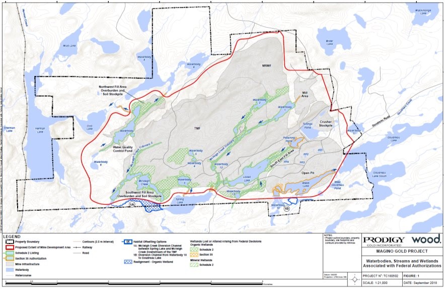
Source: Magino Gold Project Environmental Impact Statement, Wood plc.
Views Expressed
Indigenous Groups
The Batchewana First Nation, Métis Nation of Ontario, Garden River First Nation and Michipicoten First Nation expressed concerns that the loss of wetland habitat used by wildlife and species at risk would not be reversible. The Batchewana First Nation and the Métis Nation of Ontario raised concerns with the feasibility of the proponent's plan to restore peatland habitat, and the failure to assess upland wildlife habitat loss associated with the development and implementation of the fisheries offsetting plan. The proponent has committed to working with the Métis Nation of Ontario to develop a wetland mosaic within the tailings management facility and other disturbed locations. The fisheries offsetting plan will be finalized in consultation with Indigenous groups and federal authorities.
Federal Authorities
Transport Canada requested further information on the waterbodies affected by project activities to assess whether a federal authorization under the Navigation Protection Act would be required. The proponent assessed the waterbodies affected by the project and determined that the Project would not affect navigation. However, the proponent did not have any specific information about the use of boats on Webb and Lovell lakes by Indigenous groups. This information will be required for Transport Canada's regulatory process in determining the applicability of the Navigation Protection Act.
Fisheries and Oceans Canada requested further information regarding the effect of the removal of waterbodies within the project footprint on the downstream riparian and wetland habitat. The proponent indicated that in addition to three downstream watercourses within the project study area that would dry up, there would be a decrease in wetland habitat along the shore of Spring Lake within the local study area due to a decrease in water level. The proponent included these losses in its wetland assessment and has committed to including these losses in the Fisheries Act Authorization and the proposed offsetting plan.
Agency Analysis and Conclusion
Given the proposed mitigation measures and the definitions of the environmental effects rating criteria in Appendix A, the magnitude of wetland loss that is directly linked or necessarily incidental to federal decisions that may be required for the Project is rated as moderate, considering the direct loss of wetlands within the project study area, and the indirect effects to wetlands within the local study area due to changes in surface and groundwater levels. In addition, the Agency notes that the loss of wetland habitat, particularly peatlands, will affect the ecosystem function including carbon sequestration, erosion control (including shoreline erosion control), habitat for flora and fauna (including species at risk), flood abatement, groundwater recharge, nutrient retention and contaminant filtration within the local study area. Although 29 percent of the wetlands within the project study area will be removed, only 6 percent of peatlands within the regional study area (40 percent within the local study area) would be lost. Given this, the Agency is of the view that the removal of wetlands would not impact wetland function within the regional study area.
The geographic extent of wetland loss would be moderate as habitat loss will occur within the project and local study area but the duration of wetland loss would be long term with effects extending into abandonment and beyond with a continuous frequency during construction, operation and decommissioning. A fish habitat offsetting and compensation plan, progressive site rehabilitation plan and an invasive species management plan (Box 7.2-1) would be implemented, which would include the rehabilitation of approximately 40 hectares of peatlands. Consequently, the effect of the Project on wetland habitat is considered partially reversible.
Taking into account the implementation of the proposed mitigation measures (Box 7.6-1) and follow-up programs (Box 7.6-2) and the measures in Sections 7.1 and 7.2 related to the progressive rehabilitation plan, the Agency concludes the Project is not likely to cause significant adverse effects on wetlands.
7.6.2 Potential effects to Snapping Turtles
Proponent's assessment of environmental effects, mitigation and monitoring
The potential effect of the Project on Snapping Turtle was reviewed in response to concerns raised by several parties; however no evidence of Snapping Turtles was recorded during vegetation, amphibian breeding habitat, aquatic moose foraging habitat and aquatic habitat surveys. Approximately six percent of wetlands and four percent of waterbodies would be removed during construction due to activities linked to federal decisions (Figure 7:). These effects would be confined to the local study area. The project would not have a significant effect on Snapping Turtles because suitable habitat is common and well distributed within the regional study area. In addition, the implementation of the fish habitat offsetting plan and progressive rehabilitation plan would partially restore wetland habitat within the local and project study areas, aligning with the broad strategies and conservation measures presented in the federal management plan for snapping turtles [48] (Boxes 7.1-1, 7.2-1 and 7.6-1).
Views Expressed
Batchewana First Nation expressed concern with the effect of the Project on Snapping Turtle. The proponent concluded that the potential effects on Snapping Turtles were not significant and has committed to monitoring the project study area for Snapping Turtles during construction and operations. If observed within the project study area, the proponent would implement measures to mitigate effects on Snapping Turtles, including the erection of exclusion fencing and relocation of individuals from active components of the project study area.
Agency Analysis and Conclusion
The Agency assessed the potential impacts to Snapping Turtles and its habitat due to the loss and alteration of waterbodies that are linked to federal decisions (Figure 7:). Effects on the Snapping Turtle would result from habitat loss during construction. Alterations to water levels in Snapping Turtle habitat also have the potential to affect Snapping Turtles. Measures to mitigate the effects to fish and fish habitat, including mitigation measures to maintain water levels would also mitigate effects to the Snapping Turtle (Box 7.6-1). The presence of Snapping Turtle would be monitored in the project study area and if observed, measures would be implemented to prevent Snapping Turtles from accessing the project study area, such as by installing exclusion fencing, during construction and operation. Snapping Turtles observed on-site that are likely to be harmed would be captured and relocated, particularly during the construction phase (Box 7.6-2).
The Agency expects the residual effects on Snapping Turtles to occur continuously during construction, operations and decommissioning. The residual effects to Snapping Turtles would be partially reversible upon the rehabilitation of wetland habitat during decommissioning. In addition, the establishment of a fish habitat offsetting plan (Section 7.1) would indirectly provide habitat for Snapping Turtles.
The Agency concludes that the Project is not likely to cause significant adverse environmental effects on the Snapping Turtle, taking into account the implementation of mitigation measures and follow-up programs.
|
Mitigation measures to address effects to wetlands |
|
|
Follow-up measures to address effects to wetlands |
|
|
Follow-up measures to address effects to Snapping Turtles |
|
8 Other Effects Considered
8.1 Effects of the Project on Species at Risk
Subsection 79(2) of the Species at Risk Act requires the Agency to identify if and how a project is likely to adversely affect wildlife species listed in Schedule 1 of the Species at Risk Act or associated critical habitat. The Agency has confirmed that, if the project is carried out, that measures would be taken to avoid or lessen those effects and to monitor them. The measures would be taken in a way that is consistent with any applicable recovery strategy and action plans. The Project could cause adverse effects on species at risk and their recovery through habitat loss. The Agency is of the view that the Project is not likely to cause adverse effects on species at risk due to habitat loss, after taking into account key mitigation measures and monitoring programs described in Section 7.2 (Migratory Birds).
The Agency's conclusions are based on its analysis of the proponent's assessments as well as the views expressed by Environment and Climate Change Canada, the Ontario Ministry of Natural Resources and Forestry, and Indigenous groups.
Proponent's assessment of environmental effects, mitigation and monitoring
For the purposes of this assessment, the Agency defined species at risk as species listed in Schedule 1 of the Species at Risk Act or assessed as endangered, threatened or of special concern by the Committee on the Status of Endangered Wildlife in Canada. Eight species were identified within the regional study area (Table 8.1).
The Agency focused its assessment of species at risk on habitat loss. The Project's effects on migratory bird species at risk are discussed in Section 7.2 and Snapping Turtles are discussed in Section 7.6. There were no identified federal fish or plant species at risk predicted to be affected by the Project. The Agency has focused this section on mammals (bats).
| Species | Observed in RSA/LSA/PSA | Migratory Bird[1] | Status | |||
|---|---|---|---|---|---|---|
| Common Name | Scientific Name | SARA | COSEWIC | |||
|
Birds |
||||||
|
Canada warbler |
Cardellina canadensis |
RSA, LSA, PSA |
Yes |
Threatened, Schedule 1 |
Threatened |
|
|
Chimney swift |
Chaetura pelagica |
PSA |
Yes |
Threatened, Schedule 1 |
Threatened |
|
|
Common nighthawk |
Chordeiles minor |
RSA, LSA, PSA |
Yes |
Threatened, Schedule 1 |
Special Concern |
|
|
Eastern whip-poor-will |
Antrostomus vociferous |
LSA, PSA |
Yes |
Threatened, Schedule 1 |
Threatened |
|
|
Eastern wood-pewee |
Contopus vierns |
LSA |
Yes |
Special Concern, Schedule 1 |
Special Concern |
|
|
Olive-sided flycatcher |
Contopus cooperi |
RSA, LSA, PSA |
Yes |
Threatened, Schedule 1 |
Special Concern |
|
|
Mammals |
||||||
|
Little brown myotis |
Myotis lucifugus |
PSA |
No |
Endangered, Schedule 1 |
Endangered |
|
|
Northern myotis |
Myotis septentrionalis |
PSA |
No |
Endangered, Schedule 1 |
Endangered |
|
|
Reptile |
||||||
|
Snapping turtle |
Chelydra serpentina |
-[2] |
No |
Special Concern, Schedule 1 |
Special Concern |
|
|
RSA= regional study area; LSA = local study area; PSA = project study area; - = not applicable; SARA = Species at Risk Act; COSEWIC = Committee on the Status of Endangered Wildlife in Canada; [1] As defined by the Migratory Bird Convention Act (1994) [2] Snapping turtle was not identified within the RSA; however potential habitat for snapping turtle was identified within the PSA, LSA and RSA. |
||||||
Bats
Little Brown Myotis (Myotis lucifugus) and Northern Myotis (Myotis septentrionalis) overwinter in cold and humid hibernacula such as caves or mine adits. Little Brown Myotis establish summer maternity colonies in buildings or large diameter trees, and forage over waterbodies, watercourses, forest edges and forest gaps. Northern Myotis rarely occupy anthropogenic structures for roosting, preferring large trees, and forage in forest gaps.
Little Brown Myotis and Northern Myotis were recorded in a historic mine adit within the project study area using it as a winter hibernaculum and summer roost. Remains of Northern Myotis were collected within the mine adit with White Nose Syndrome (Pseudogymnoascus destructans). White Nose Syndrome has caused a 94 percent decline in known numbers of hibernating Myotis bats in Nova Scotia, New Brunswick, Ontario and Quebec.[49] Maternity sites (trees, rock crevices, buildings, bat houses) and hibernacula (cave, mine or buildings) are the main limiting habitat features for Little Brown Myotis and Northern Myotis.
The historic mine adit hibernaculum and 1118 hectares of bat foraging and roosting habitat would be removed during construction. To reduce the predicted adverse effects of the Project, habitat loss would be restricted, by minimizing the project footprint. In addition, a progressive rehabilitation plan would be implemented to revegetate cleared areas during the operation, decommissioning and abandonment of the Project, as discussed in Sections 6.3 and 7.2.
The removal of foraging and roosting habitat would not have a significant effect on Little Brown Myotis and Northern Myotis. It is anticipated that bats would avoid the project study area in response to sensory disturbance, resulting in displacement to the local or regional study areas for foraging during construction, operation and decommissioning. During decommissioning and abandonment, foraging and roosting habitat would be progressively rehabilitated, allowing for bats to return to the project study area.
The removal of the existing hibernaculum would not cause a significant effect to Little Brown Myotis and Northern Myotis because the existing hibernaculum was considered of lower quality due to the presence of White Nose Syndrome and there are potential hibernation and roost sites, and known hibernacula within 10 kilometers of the project study area (but outside of the regional study area). Further, the proponent would be required to meet provincial regulatory requirements under Ontario's Endangered Species Act[50] for the Little Brown Myotis and Northern Myotis.
Views Expressed
Indigenous groups
Garden River First Nation and the Michipicoten First Nation expressed concern regarding the reversibility of effects due to habitat loss on wildlife, including species at risk. Batchewana First Nation expressed concern with survey methodology for bats and requested further investigations to ensure that these species are not affected by the Project. Batchewana First Nation, Garden River First Nation and Michipicoten First Nation recommended that the proponent work with the Ontario Ministry of Natural Resources and Forestry to develop mitigation to prevent adverse effects on Little Brown Myotis and Northern Myotis.
The proponent responded that provincial regulatory requirements would be addressed, as required by the Ontario Ministry of Natural Resources and Forestry. The proponent also held technical working group meetings with Batchewana First Nation to provide clarity on the potential effects of the Project on species at risk and mitigation measures. The proponent is currently engaging with Garden River First Nation to address any outstanding concerns about the potential effects of the Project. The proponent also committed to working with all Indigenous groups on the development of revegetation objectives and the formation of an Environmental Monitoring Committee.
Batchewana First Nation, Garden River First Nation, and Michipicoten First Nation expressed concern with the effect of the Project on Wood Turtles [51] (Glyptemys insculpta). The proponent assessed the habitat range of Wood Turtle, and determined in consultation with the Ontario Ministry of Natural Resources and Forestry that Wood Turtle are not expected to occur in the region.
Federal authorities
Environment and Climate Change Canada recommended the proponent provide mitigation measures and a follow-up program to prevent adverse effects on Little Brown Myotis and Northern Myotis due to the loss of critical habitat. The proponent has proposed several mitigation measures to address the loss of the hibernaculum including remediation of nearby hibernaculum, construction of an artificial hibernaculum or providing support to White Nose Syndrome research. In addition to meeting provincial regulatory requirements, the proponent has committed to implementing these mitigation measures and a monitoring program in consultation with Environment and Climate Change Canada, and the Ontario Ministry of Natural Resources and Forestry.
Agency Analysis and Conclusion
The Agency has determined that the measures the proponent would implement to meet provincial regulatory requirements and the key mitigation measures described in Sections 7.2 would reduce adverse effects on species at risk. These measures are consistent with the proposed recovery strategies for the identified federal species at risk.
The main mitigation discussed in Section 7.2 in relation to birds, and equally applicable to other species at risk, is the avoidance of nesting periods during vegetation clearing and progressively rehabilitating with native species. With respect to bats, if unmitigated, the loss of existing Little Brown Myotis and Northern Myotis hibernaculum would have an adverse effect on the known populations of Little Brown Myotis and Northern Myotis in the regional study area because the historic mine adit is considered critical habitat under the Species at Risk Act. Despite the mitigation measures to reduce adverse effects on Little Brown Myotis and Northern Myotis at the population level, the Agency acknowledges that the Project would affect individuals and increase the risk of mortality.
The Agency recommends to the proponent that it consider applicable recovery strategies and action plans for birds, turtles and bats that may be affected by the Project as outlined under the Species at Risk Act, to reduce or prevent the decline of these species.[52]
8.2 Effects of Accidents and Malfunctions
Proponent's assessment of environmental effects and mitigation
There is the potential for accidents and malfunctions to occur throughout all phases of the Project, which could lead to adverse impacts on the Project and its surrounding environment. The proponent has described the potential effects of project-related accidents and malfunctions, as well as their corresponding preventative and response measures. Both structural failures, such as mine rock management facility slope failure, open-pit slope failure, as well as accidents, such as explosives accident, tailings pipeline failure, were assessed. The accident or malfunction that poses a risk outside the project footprint is the risk of a tailings management facility dam failure. The Agency has focused its analysis on the tailings dam failure as it is the scenario where environmental effects would be most severe and extend beyond the project footprint. For the management of accidents and malfunctions where effects would be confined to the project footprint, the proponent has committed to developing and implementing an emergency response plan that outlines the measures to be taken, including communication measures to ensure the notification of both federal and provincial authorities, Indigenous groups, and the public.
Tailings management facility dam failure
A worst-case scenario regarding a tailings dam failure is defined as a full breach of the dam in the final stage of the operations phase and would involve a portion of the tailings solids and the full contents of the liquid (3.25 million cubic metres) being released in one of two possible breach positions. A failure in the southwest portion would affect the Spring Lake and McVeigh Creek extending into the Michipicoten River watershed for approximately 32 kilometres downstream to the Whitefish Lake Reservoir. A failure in the northwest portion would affect the Otto and Herman systems into the Magpie River watershed for approximately 22 kilometres downstream to the Steep Hill Generating Station Reservoir Dam. Potential environmental effects would include temporary increase in surface water flows and levels, degraded water quality for several months, localized fish and wildlife mortality, and damage to fish and wildlife habitat. Effects to Indigenous uses would be primarily to the ability to fish within the affected watershed and last until fish populations recovered.
The proponent has indicated that the dams for the tailings management facility, including the reclaim pond, would be constructed in stages, as the volume of tailings increases and water pooling changes.Further, thickened tailings in the form of slurry would be transported from the processing plant to the tailings management facility embankment using a pipeline. In addition to these preventative design measures, the proponent has committed to the following:
- Incorporate 100 year flood event and maximum credible earthquake design criteria;
- Design all dams according to the recommendations from the Canadian Dam Association's Dam Safety Guidelines that are relevant to mining dams and the requirements of the Ontario Ministry of Natural Resources and Forestry or the Ontario Ministry of Energy, Northern Development and Mines, as applicable;[53]
- Construct a natural rock cut spillway for each stage of embankment construction in order to provide a safe exit point for any excess water that may accumulate;
- Design the mine rock management area to extend from the north-east and south faces of the dam to provide extra support for the embankment; and,
- Implement a site-specific Operation, Suspension and Maintenance Manual that establishes clear tailings management facility performance standards.[54]
In the event of a dam failure or imminent failure in the tailings containment portion of the facility, the proponent would initiate their emergency response plan. The initial response would be to protect worker health and safety and shut down the pumping of tailings into the facility. In addition, the emergency response plan would include the following:
- Cease plant operations and the seepage reclaim system;
- Undertake emergency repairs;
- Reroute the reclaim system to the pit to reduce the amount of effluent released during emergency repair;
- Contain the spill using temporary devices such as earthen or snow dams, silt fences, sand bags, and other available equipment;
- Report the incident in accordance with statutory responsibilities;
- Develop a remedial action plan in consultation with regulatory agencies and local Indigenous groups to support habitat recovery;
- Remove and properly dispose of potentially impacted material into the tailings management facility in the event that water breaches the seepage collection system; and,
- Rehabilitate the affected areas and implement a monitoring program to measure the success of the rehabilitation.
Details of the recovery strategy would be dependent on the extent and nature of the spill, but would include cleaning of tailings spilled on land between the tailings management facility and adjacent waterbodies as soon as the tailings management facility is stabilized. Since the tailings are non-acid generating, aquatic habitats would recover naturally over many years.
Views expressed
Garden River First Nation, Missanabie Cree First Nation, and Michipicoten First Nation inquired about the likelihood of a tailings management facility dam breach, the potential environmental effects of a tailings dam breach on downstream communities and waterbodies, and the response to such an event. The proponent indicated that there is a low probability for a dam breach to occur, and that if such a failure were to occur, the most substantial environmental effects would be in the aquatic environment within the flood path. In addition to design features to prevent a tailings management facility dam breach, ongoing monitoring of the tailings dam would occur. Further, the proponent stated that the Emergency and Spill Response Management Plan would be implemented in such an incident.
Agency Analysis and Conclusion
The Agency is of the view that the proponent has appropriately identified and assessed potential accidents and malfunctions associated with the Project. The proponent examined structural failures, accidents, and other malfunctions, such as fires. The proponent took the risks of accidents and malfunctions into account in the design of the Project to minimize them. The likelihood of a tailings management facility dam failure has also been minimized by preventative design measures, which would be outlined in the Emergency and Spill Response Management Plan, and commitments such as adhering to by the Canadian Dam Association Dam Safety Guidelines. The Agency further notes the proponent would be required to adhere to provincial requirements, including those related to dam structures. While a tailings management facility dam failure could cause significant adverse effects on aquatic habitat, the Agency notes that the probability of such an event occurring would be low, given the preventive measures the proponent committed to implement.
The Agency has considered the measures proposed by the proponent and comments received from Indigenous groups, and is of the view that the Project is not likely to cause significant adverse environmental effects due to accidents and malfunctions.
8.3 Effects of the Environment on the Project
Pursuant to paragraph 19(1) (h) of CEAA 2012, the environmental assessment must take into account any change to the Project that may be caused by the environment, including extreme and periodic weather events. These factors may damage project components and increase the potential for accidents and malfunctions (Section 8.2).
Proponent's assessment of environmental effects and mitigation
Several environmental factors could have an effect on the Project as discussed in the relevant sections below, which include: drought, temperature fluctuations, forest fires, storms, and seismic activity. Climate change trends for the area suggest an increase in average temperatures during the fall and winter months, with the largest increase in precipitation during the winter and spring. However, these trends do not change the conclusions of the environmental assessment after taking into account design measures and adaptive management measures.
Drought
As a result of climate change, the frequency of droughts is projected to increase in the future with an increased frequency of extreme weather events. Drought conditions could lead to increased dust on-site, reduced availability of water for mining operations, and therefore an increased intake of water from Goudreau Lake. To mitigate this, the Project has been designed for 1-in-100 year severe drought conditions and will operate in accordance with the water management system. In the event of a drought, further measures will be implemented to control fugitive dust.
Temperature fluctuations
The net effect of temperature fluctuations would be more frequent freeze-thaw events and increased precipitation during the winter and spring, which could cause freezing of water management equipment. To prevent this, project components would be regularly inspected and damages repaired.
Forest fires
Forest fires could spread to the project study area from nearby areas, which could ignite on-site fuel storage and other flammable materials resulting in explosions during operation, and the loss of habitat created during progressive rehabilitation. To minimize the likelihood of forest fires spreading onto the project study area, fuel would be stored behind a non-vegetated buffer, and an adequate number of trained fire-fighting staff would be available to respond to a fire.
Storms
Rain, ice, wind, and snow storms could increase in both frequency and intensity as climate change continues. The storms could damage exposed infrastructure either due to direct physical damage, or heavy snow or ice buildup. To minimize infrastructure damage, mining activities would be curtailed during storms, the water management system would include capacity for storm water, any snow/ice buildup on would be cleared before resuming operations, and any damages to infrastructure would be repaired as needed.
Seismic activity
A seismic event could affect infrastructure, however the Project is located in an area which is considered to have a very low level of seismic activity. To minimize the likelihood of seismic activity induced damage, project components (including dams, infrastructure and buildings) would be designed, constructed and monitored in accordance with the appropriate standards.[55]
Views expressed
Red Sky Métis Independent Nation expressed concern that the Project did not consider climate change and noted that the Project could be affected by flooding. The proponent indicated that the water management system would be designed and operated to handle excess water in extreme weather events due to climate change. The system would include site water management ponds that would be operated in a manner that maintains sufficient capacity to hold the volume of water from a 1:100 year rainfall for 24 hours. For the tailings reclaim pond, the proponent indicated that it would be operated to maintain sufficient capacity to hold the volume of water from a 1:100 year rainfall or snowfall event.[56]
Agency Analysis and Conclusion
The Agency is satisfied that the proponent has adequately considered the effects of the environment on the Project and that the proposed design measures, mitigation measures and response measures are appropriate to account for the potential effects of the environment on the Project.
8.4 Cumulative Environmental Effects
The Project could cause cumulative environmental effects, in combination with the environmental effects of other past, existing and reasonably foreseeable projects or activities, on the following valued components: (1) migratory birds, and (2) Indigenous uses.
The Agency is of the view that the Project, in combination with past, present and reasonably foreseeable projects, is not likely to cause significant adverse cumulative environmental effects and that no additional mitigation or follow-up measures are required.
In making this determination, the Agency considered the project effects, the effects of other projects, views expressed by federal departments, provincial ministries, Indigenous groups and the public, and the proposed mitigation measures (Chapter 7), and the existing federal and provincial regulatory regimes.
Approach and Scope
The proponent identified past, current, and future physical activities that could potentially interact with the Project in its evaluation of cumulative effects, including mining operations, forestry activities, transportation networks, and power generation facilities (Figure 8:). Activities retained for assessment, include past, present or future actions that have an additive effect in combination with the Project, and are shown in Table 8.2. The proponent assessed how project effects could incrementally contribute, taking into account the geographic extent, duration and timing of the effects. The proponent's assessment also considered existing regulatory regimes that influence how projects are managed. After the implementation of proposed mitigation measures discussed in Chapter 7, the proponent predicts the potential for cumulative effects on migratory birds and Indigenous uses within the biophysical regional study area (approximately 110 square kilometres).
| Physical Activity | Distance to the Project | Description | Potential interaction with the Project |
|---|---|---|---|
|
Island Gold Mine |
2 kilometres east of the Project, within the local study area |
Underground gold mine. |
The expansion is expected to overlap temporally with the project. Increase in production capacity could increase the water taken from Miller Lake, the effluent proposed to be discharged into Goudreau Lake, and the contaminants expected to be released into the air. |
|
Magpie Forest Management Unit |
Project footprint is within the management unit |
Forestry management area. Management plan in place for 2014-2019. |
Removal of forested areas within the regional study area. |
|
Algoma Forest Management Unit |
Regional study area is within the management unit |
Forestry management area. Management plan in place for 2014-2019. |
Removal of forested area in the regional study area (949 hectares within the regional study area between by 2020). |
Figure 8 - Projects or activities that could potentially interact with the Project's effects
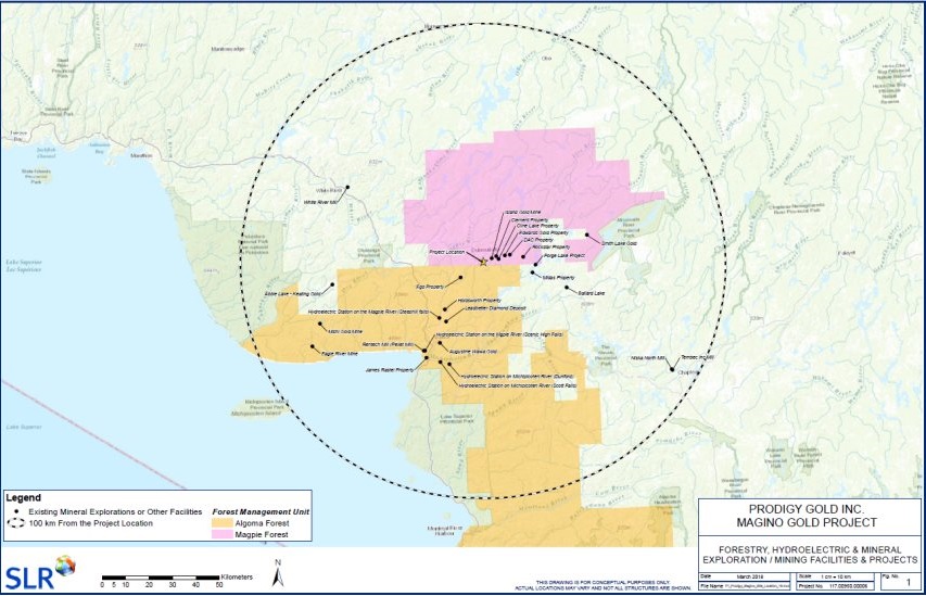
Source: Magino Gold Project Environmental Impact Statement, SLR Consulting.
8.4.1 Migratory Birds
Proponent's assessment of environmental effects, mitigation and monitoring
The total amount of terrestrial vegetation loss predicted in the regional study area would be approximately 2 975 hectares. Of this total, approximately 1 070 hectares would be lost due to the Project and 949 hectares from forest harvesting activities associated with the Magpie Forest Management Unit. There is currently 1 076 hectares of terrestrial habitat already disturbed from historical logging and mining activity in the regional study area. It is assumed that the additional removals would occur simultaneously over the construction period (3 years) of the Project. However, the combination of existing disturbed area as well as area anticipated to be disturbed by the Project represents approximately 27 percent of the total regional study area.
The Project in combination with the Magpie forestry management area could cause cumulative effects to migratory birds through the removal of habitat in the regional study area. The habitat loss would reduce the abundance of migratory birds by 9.4 percent in the regional study area, but is not expected to have any measurable effect on migratory bird populations. Terrestrial vegetation in the boreal forest is subject to natural disturbance from forest fires, insect infestations and blowdowns, and to which wildlife populations are adapted. Furthermore, the 949 hectares removed due to planned forestry activities would be subject to provincial legislation [57] in place to ensure potential effects to the environment including the sustainable management of forests are considered. The vegetated area lost to the project footprint would be partially rehabilitated during abandonment (Sections 6.3, Box 7.2-1).
Agency Analysis and Conclusion
Taking into account the predicted residual effects, the proximity to other projects or activities, the implementation of mitigation measures and the recommended follow-up programs for Project effects (Boxes 7.2-1 and 7.2-2), the Agency concludes that the Project, in combination with existing and reasonably foreseeable projects or activities, is not likely to cause significant cumulative effects on migratory birds.
The Agency agrees that the boreal terrestrial habitat suitable for migratory birds is adapted to disturbance. Further, the Agency notes that provincial forestry management practices take into consideration conservation of biodiversity and enhancement or protection of wildlife habitat and watersheds. The Agency also acknowledges that the provincial forestry management process sets objectives for indicator species prior to determining areas where timber harvest is permitted, and factors in the implication of private lands, mining activities, locations of natural resource features, and land uses and values of interest to Indigenous peoples. The Agency notes that as part of the provincial Class Environmental Assessment, an assessment of impacts due to the disposition of Crown land on migratory birds considered endangered or threatened under Ontario's Endangered Species Act would be considered. Therefore, the Agency is of the view that no further mitigation or follow-up measures are required for the Project.
8.4.2 Indigenous uses: Current use of lands and resources for traditional purposes
Proponent's assessment of environmental effects, mitigation and monitoring
As discussed in Section 8.4.1, 2 975 hectares of terrestrial vegetation would be lost due to the interactions between the Project, historical and future activities. The Project could cause cumulative effects to Indigenous uses through the loss of habitat for species of interest to Indigenous peoples. The loss of vegetation could affect plant gathering, and cause changes in the distribution of species of interest to Indigenous groups, including waterfowl, moose and other mammals, which could affect the practices of hunting and trapping. The changes to the environment from the expansion of the Island Gold Mine are not expected to cause any effects to fish, water or air quality, as the project footprint would not change and the mine would be required to comply with existing provincial regulatory requirements for air and water quality.
Given the limited hunting and trapping activities identified in the study areas, the limited effect of the Project on migratory birds, moose, and other mammals, and provincial regulations that would ensure population level effects were avoided, it is unlikely that the project in combination with the other identified activities would cause a noticeable change in the ability of Indigenous groups to practice hunting and trapping as before.
Views Expressed
Batchewana First Nation, Michipicoten First Nation, the Métis Nation of Ontario and the Red Sky Métis Independent Nation all raised concerns about the potential for cumulative effects of the Project in combination with the neighbouring Island Gold Mine on Indigenous uses including fishing and gathering. The proponent responded that the baseline data on water and air quality take into account the effects of Island Gold Mine, and that its future expansion would not affect water or air quality as they would need to continue to remain below established provincial and federal criteria.
The Red Sky Métis Independent Nation expressed concern that access to resources for traditional purposes had become restricted from historical activities (specifically, due to road damage) and would experience further access restrictions due to the Project. The proponent has addressed this concern through an impact benefit agreement with the community.
Agency Analysis and Conclusion
Taking into account the predicted residual effects, the proximity to other projects or activities, and the implementation of mitigation measures and the recommended follow-up programs measures for migratory birds and Indigenous uses (Boxes 7.2-1, 7.2-2, 7.3-1 and 7.3-2), the Agency concludes that the Project, in combination with existing and reasonably foreseeable projects or activities, is not likely to cause significant cumulative effects on Indigenous uses.
The Agency agrees that the predicted residual effects on Indigenous uses due to the Project are changes in the availability of resources and access to lands and resources (Section 7.3.1), and changes in the quality of experience due to sensory disturbances (Section 7.3.2). The cumulative effects on Indigenous uses due to the changes in the availability of resources from the Project's interaction with past, present and reasonably foreseeable activities identified in Table 8.2 would change the availability and spatial arrangement of habitat for species of use to Indigenous groups and could displace or alter the patterns of use, but would not affect populations of species important for Indigenous uses and would not affect the ability of Indigenous groups to continue traditional practices as before. The Agency notes that, as described in Section 8.4.2, provincial forestry management practices are consistent with principles of sustainable development and would be adjusted based on all land uses, including mining and Indigenous uses. Further, as noted in Section 8.4.2, as part of the provincial Class Environmental Assessment for Resource Stewardship and Facility Development, the province would assess the impacts of the disposition of Crown land on continued Indigenous use. Therefore, the Agency is of the view that no additional mitigation or follow-up measures are required for the Project.
9 Impacts on Aboriginal or Treaty Rights
In alignment with the Agency's overall approach to consultation and the Updated Guidelines for Federal Officials to Fulfill the Duty to Consult (March 2011), the Agency sought information from all potentially impacted Indigenous groups about the nature of their Aboriginal and treaty rights as protected under section 35 of the Constitution Act, 1982 and how they may be impacted by the Project. The Agency considered any new information arising from the proponent about the potential impacts of the Project, as they emerged, in an effort to better understand the nature, scope and extent of adverse impacts on rights. Where potential impacts on rights were identified, the Agency took into account the appropriate mitigation measures before determining the severity of the impacts.
9.1 Existing Aboriginal or Treaty Rights in the Project Area
The Project is located in the Robinson-Superior Treaty (1850) area of Ontario, which covers the area of the north shore of Lake Superior. This treaty maintains an ongoing right to hunt and fish throughout the treaty territory. Fishing and hunting occur within the study areas of the Project. Other traditional uses of the lands and resources within the study areas, which are Aboriginal rights protected in section 35 of the Constitution Act, 1982, include trapping, plant harvesting, and the use of lands and resources for cultural purposes.[58]
Seven First Nations were identified for consultation on the Project: Michipicoten First Nation, Pic Mobert First Nation, the Red Sky Métis Independent Nation, Missanabie Cree First Nation, Batchewana First Nation, Garden River First Nation and the Métis Nation of Ontario. Each of the Indigenous groups identified by the Agency for consultation has a history of occupancy and traditional land use in the region and beyond.
The Red Sky Métis Independent Nation represents the descendants of the 84 'half breeds' who were recognized as beneficiaries of the Robinson-Superior Treaty. Missanabie Cree First Nation is a signatory to Treaty 9, which maintains hunting, trapping and fishing rights throughout the treaty territory. As per a land use study undertaken by Missanabie Cree First Nation in 2003, their traditional territory extends outside the Treaty 9 area and into areas in the Robinson-Superior Treaty area including in and around Missanabie Lake, Dog Lake and Wabatongushi Lake, which are within the project study areas. Michipicoten First Nation is a signatory to the Robinson-Superior Treaty and maintains traditional territory which contains the project study areas. Batchewana First Nation and Garden River First Nation are located within the Robinson-Huron Treaty area, which maintains the same rights for First Nation signatories as the Robinson-Superior Treaty. Batchewana First Nation and Garden River First Nation have shared traditional territory with Michipicoten First Nation, and had their hunting rights in the project study area recognized in a 1997 lower court decision (R. v. McCoy).
The Project is located within the Métis Nation of Ontario – Historic Sault Ste. Marie traditional territory. The Métis have been successful in establishing Métis rights through the R. v. Powley (2003) Supreme Court decision. The Métis also hold Aboriginal rights which are protected under section 35 of the Constitution Act, 1982. The Métis Nation of Ontario indicated that numerous Métis citizens represented by them live and/or harvest within or extensively use the study areas.
9.2 Potential Adverse Impacts of the Project on Aboriginal or Treaty Rights
Members from the Missanabie Cree First Nation, Michipicoten First Nation, the Red Sky Métis Independent Nation and the Métis Nation of Ontario, due to their proximity to and/or traditional use of lands and resources in the study areas, as well as issues raised during the environmental assessment process, would be most likely to face direct impacts from the Project such as the overprinting of fishing sites and displacement of hunting practices. Indirect effects such as diminished ambient conditions are also assessed.
The Project will result in the removal of terrestrial and aquatic habitat, increases in sensory disturbance and changes to the visual landscape which could cause effects to the availability of traditional plants and preferred fish and wildlife species. This could lead to changes in the quality of experience by Indigenous groups during the exercise of hunting, fishing and traditional plant harvesting rights. These impacts are discussed below.
9.2.1 Hunting
Proponent's Assessment
As noted in Section 7.3, Missanabie Cree First Nation and the Métis Nation of Ontario indicated current hunting practices in the study areas, while Michipicoten First Nation and Batchewana First Nation indicated historic hunting. The Project is also located at the extreme south boundary of a Batchewana First Nation hunting area that is approximately 4800 square kilometres. No site-specific hunting was identified in the project study area with the exception of Missanabie Cree First Nation, who identified a hunting site for large game between Webb and Goudreau lakes. The local and regional study areas are associated with greater hunting activity, with large and small mammal and waterfowl hunting sites identified. Missanabie Cree First Nation identified trapping in the eastern portion of the regional study area. However, only a small portion of the trapline identified overlaps the regional study area and is highly unlikely to experience any effects due to the Project.
Moose and waterfowl make limited use of the project study area. Moose are concentrated further to the south of the project study area, and are well distributed throughout the regional study area. There is no significant waterfowl habitat in the project study area and suitable habitat is readily found in the local and regional study area. Black bear foraging habitat would also be removed within the project study area, however it is abundant within the regional study area, and progressive rehabilitation measures would restore foraging habitat during decommissioning and abandonment. Sensory disturbance from the Project would create barriers to wildlife use in the project study area during construction, operation, and decommissioning. Some limited effects to the local study area may occur due to occasional startle effects from blasting and low level disturbance, however the effect on species availability is unlikely to be measurable. The Project could cause effects to the quality of experience of hunting due to sensory disturbance extending into the local study area (Sections 6.1 and 7.2), loss of habitat within the project study area(Section 7.2. and 7.3) and changes in the visual landscape extending to the regional study area(See Section 6.1 and 7.3). However, the project study area is not highly valued for hunting, and visual effects would decrease with distance from the Project.
The proponent would progressively rehabilitate the site to meet provincial requirements, as noted in Sections 6.3, 7.2, Box 7.2-1, and 7.3. Further, the proponent would prohibit hunting within the property boundary.
Views Expressed
The Métis Nation of Ontario, Red Sky Métis Independent Nation, Michipicoten First Nation, and Batchewana First Nation expressed concerns about the Project's effects on wildlife that could impact hunting, which are addressed in sections 7.3 and 8.4, and summarized in Appendix D.
Agency Analysis
Taking into account that the local study area is not valued as a hunting location, the localized nature of potential effects to resources used for hunting, and mitigation and accommodation measures, the Agency determined that the potential impacts to these activities are low. While there is no residual effects to habitat beyond the project study area, there may be residual effects to the quality of experience in exercising hunting rights beyond the project study area, however these are considered low. The loss of the potential for hunting in the project study area remains a residual effect, but the Agency notes the proponent committed to establishing an Environmental Monitoring Committee, which would review mitigation and monitoring plans, and review monitoring results. Indigenous groups that have been involved in the federal environmental assessment process would be invited to participate on this committee. No impacts are expected to trapping rights due to the Project.
9.2.2 Fishing
Proponent's Assessment
Missanabie Cree First Nation and Métis Nation of Ontario indicated fishing areas that include the project study area. The Métis Nation of Ontario identified fishing areas through a traditional use study; however specific locations were not made available to the Agency. Missanabie Cree First Nation specifically identified Webb and Lovell lakes as sites where current fishing, although limited, occurs. The fish species being fished (Walleye and Northern Pike) in these lakes are also found in Goudreau Lake in the local study area and further east in the regional study area. Missanabie Cree First Nation also identified Goudreau and Spring lakes as fishing locations, as well as two fish weirs currently used between Bearpaw and Pine lakes at the border of the local and regional study areas. Michipicoten First Nation, Missanabie Cree First Nation, and Batchewana First Nation specifically noted the importance of lakes as far as 20 kilometers beyond the regional study area to the east – notably Dog, Trout, and Wabatongushi lakes.
As discussed in Sections 6.2 and 7.1, Webb and Lovell lakes would be drained as part of the Project, permanently removing them as a location for exercising fishing rights. To mitigate the impact to fish and loss of fish habitat from the draining of Webb and Lovell lakes, mitigation measures (Section 7.1) are proposed that include fish relocation and a fish habitat offsetting plan designed in consultation with Indigenous groups. However, lakes within the project and local study areas are not valued for fishing by Indigenous groups. Some lakes in the regional study area, such as Dreany and Mountain lakes, are important for the exercise of fishing rights, but there are a greater number of important fishing sites identified beyond the regional study area. As previously discussed, the Project could have effects to the quality of experience for Missanabie Cree First Nation and the Métis Nation of Ontario when exercising fishing right due to sensory disturbance; however these effects are not expected to extend beyond the local study area. Subtle visual changes may be experienced beyond the regional study area, depending upon the location, but would decrease with distance from the Project.
Views Expressed
Garden River First Nation, Michipicoten First Nation and the Métis Nation of Ontario expressed concern about increases in contaminants in fish, which would affect the ability of community members to fish due to health concerns. These concerns are addressed in Sections 7.1 and 7.4 and summarized in Appendix D.
Batchewana First Nation, Michipicoten First Nation, and the Red Sky Métis Independent Nation commented on the proponent's plan to offset the loss of fish and fish habitat, which would help to mitigate impacts to fishing activities. These comments are addressed in Section 7.1 and summarized in Appendix D.
Batchewana First Nation, Michipicoten First Nation, the Métis Nation of Ontario and the Red Sky Métis Independent Nation all raised concerns about the potential for cumulative effects of the Project on fishing. These concerns are addressed in Section 8.4 and summarized in Appendix D.
Agency Analysis
Taking into account the location of Indigenous fishing sites that could be directly impacted by the Project (within the project study area and parts of the local study area) as well as the number of Indigenous fishing sites in the regional study area and beyond where impacts are not significant, the mitigation measures and follow-up programs described in Sections 6.1, 6.2, 7.1, 7.3 and 7.4, and the proponent's accommodation measures, the Agency concludes that the severity of potential impacts on the overall quality of experience in exercising Indigenous fishing rights is low. The Agency notes the proponent committed to establishing an Environmental Monitoring Committee, which would review mitigation and monitoring plans, and review monitoring results. Indigenous groups that have been involved in the federal environmental assessment process would be invited to participate on this committee.
9.2.3 Traditional Plant Gathering
Proponent's Assessment
The Métis Nation of Ontario reported that harvesting of traditional plants occurs along Goudreau Road, in the local and regional study areas and beyond, and in a large harvesting area that intersects the western portion of the project study area and extends well beyond the regional study area. Missanabie Cree First Nation and the Métis Nation of Ontario identified the area around Summit Lake, located in the regional study area, as a berry picking location. Missanabie Cree First Nation and Red Sky Métis Independent Nation reported that berries and medicinal plants are harvested in the regional study area. The area beyond the regional study area is widely available for traditional plant gathering.
The Project would result in the removal of vegetation during construction of the power line and access roads in the project study area. Further, there would also be increased traffic on Goudreau Road during operation of the Project, potentially disrupting gathering activities on the shoulders of the road. While the area around Summit Lake would be maintained as a berry picking location, access to the area would be impacted by the Project. As previously discussed, the Project could have effects to the quality of experience for Missanabie Cree First Nation, the Métis Nation of Ontario and Red Sky Métis Independent Nation when exercising traditional plant gathering due to sensory disturbance; however these effects are not expected to extend beyond the local study area. Subtle visual changes may be experienced beyond the regional study area, depending upon the location, but would decrease with distance from the Project.
Traditional plant gathering is limited within the project and local study area and likely to only impact the Métis Nation of Ontario. The proponent would progressively rehabilitate the site to meet provincial requirements, as noted in Section 6.3, 7.2 and 7.3. The Agency has identified mitigation and follow-up measures to be included as conditions of approval, which would include a site rehabilitation plan (Box 7.2-1), and more specifically the development and implementation of a plan to plant species of value for gathering activities identified in consultation with Indigenous communities (Box 7.3-1). Berries and medicinal plants are harvested in the regional study area, although numbers and density are extremely low compared to areas beyond the regional study area. There may be increased competition for berries with bears due to loss of habitat from the project study area; however this effect would not be measurable.
Views Expressed
Batchewana First Nation, Michipicoten First Nation, the Métis Nation of Ontario and the Red Sky Métis Independent Nation raised concerns about the potential for cumulative effects of the Project on gathering. These concerns are addressed in Section 8.4 and summarized in Appendix D.
The Métis Nation of Ontario and the Red Sky Métis Independent Nation raised concerns about the potential impacts of the Project on country foods through contamination. These concerns are addressed in Section 7.3 and summarized in Appendix D.
Agency Analysis
Taking into account the limited use of the study areas for traditional plant gathering compared to other areas outside the regional study area, and the accommodation measures identified by the proponent, the Agency considers the severity of potential impacts to the exercise of gathering rights to be low.
Gathering activities occur primarily in the local and regional study areas and beyond where impacts will be less pronounced, although the Project could change the experience of gathering into the regional study area due to the visual impact posed by the mine rock management facility. The impact on the exercise of rights related to traditional plant gathering due to changes in the experience would be applicable to for Missanabie Cree First Nation, the Métis Nation of Ontario and the Red Sky Métis Independent Nation. In addition, Batchewana First Nation identified that Black Birch and Muskeygoosh (Swamp Valerian) are two species of importance. The proponent has committed to consulting with Indigenous communities regarding the design and implementation of mitigation measures to address effects to current use of lands and resources for traditional purposes (Box 7.3-2). Further, the proponent has engaged with Indigenous groups to identify plant species for inclusion in the rehabilitation plan (Section 7.2).The loss of traditional plant gathering in the project study area remains a residual effect, but the Agency notes the proponent committed to establishing an Environmental Monitoring Committee, which would review mitigation and monitoring plans, and review monitoring results. Indigenous groups that have been involved in the federal environmental assessment process would be invited to participate on this committee.
9.2.4 Use of Lands and Resources for Cultural Purposes
Proponent's Assessment
Missanabie Cree First Nation and the Métis Nation of Ontario identified uses of the land for cultural purposes within the local and regional study areas. Missanabie Cree First Nation identified a cultural site in the local study area just south of Lovell Lake in a Traditional and Ecological Knowledge Study, however its specific location, use (whether historic or current) and purpose could not be confirmed by the proponent through engagement. The Métis Nation of Ontario identified water routes from Mountain Lake (in the regional study area) to Otto Lake (in the local study area) and a bush camp west of Summit Lake in the regional study area as culturally important. The Project could result in a reduced quality of experience from the use of cultural sites due to sensory disturbance in part of the local study area (Section 7.3) and due to the visual impact of the mine rock management facility that could extend as far as the regional study area (Section 6.3).
Views Expressed
The Red Sky Métis Independent Nation and Batchewana First Nation expressed concerns about the effects of noise on Indigenous uses. These concerns are addressed in Section 7.3.
Agency Analysis
Taking into account the limited use of lands and resources for cultural purposes in the study areas compared to other areas outside the regional study area, and the accommodation measures identified by the proponent, the Agency considers the severity of potential impacts to the exercise of rights to use lands and resources for cultural purposes to be low.
There would be no removal of sites identified as used for cultural purposes, and the potential effects identified by the proponent are negligible but there would be noticeable visual and auditory changes to the background conditions. These effects would be almost entirely reversed after decommissioning, with the exception of the slight change in visual resources due to the visibility of the mine rock management facility at the cultural sites identified by Missanabie Cree First Nation, and the Métis Nation of Ontario. However, this would be mitigated by revegetation undertaken during the rehabilitation of the project footprint. Further, the Agency understands that the proponent has negotiated agreements with both Indigenous groups as an additional mechanism for accommodating potential impacts to the exercise of traditional rights to use the lands for cultural purposes, including the use of water routes, camps and cultural sites.
9.3 Engagement with Garden River First Nation
As noted in Section 4.2.1, the Agency first contacted Garden River First Nation about the Project in February 2015 following information received from the proponent. While in November 2016 Garden River First Nation notified the Agency that the Project was not likely to have any impacts on community members, on May 26, 2017, the community indicated the Project is likely to have impacts on its community members and provided a map that provided information on traditional land use activities in the vicinity of the Project. The map did not indicate any overlap between the project footprint and the areas where land use was identified by Garden River First Nation. In 2018, Garden River First Nation, upon review of the proponent's documents related to potential impacts on the community, raised concerns. The Agency provided clarification to both the proponent and Garden River First Nation on the requirements for engagement and gathering of information to inform the effects assessment. The proponent provided funding to Garden River First Nation to undertake a traditional land use study to help further understand the potential impacts of the Project on Garden River First Nation.
The Agency continued the preparation of this report while the proponent and Garden River First Nation collaborated on the completion of the traditional land use study, as the Agency relied on the proponent's commitment, made in June 2018, to address any impacts identified as a result of the traditional land use study. Further, the Agency reassured Garden River First Nation of its intent to consult with the community on this report and the companion potential conditions document prior to providing advice to the Minister to ensure that specific issues of interest to Garden River Nation were appropriately characterized.
9.4 Agency Conclusions Regarding Impacts to Aboriginal and Treaty Rights
The Agency has identified mitigation and follow-up measures to be included as conditions of approval, which would include consultation with Indigenous communities where applicable. Taking into account effects and proposed mitigation measures outlined in Chapters 6 and 7 and Appendices C and D, and the limited use of the study areas for the exercise of rights, the Agency is satisfied that the potential impacts of the Project on rights have been adequately identified and appropriately accommodated.
The Agency acknowledges that the proponent would accommodate any residual impacts not mitigated through the terms of existing agreements or through agreements currently being negotiated with individual Indigenous groups. The Agency understands that the proponent has entered into agreements with the Métis Nation of Ontario and the Red Sky Métis Independent Nation, and is currently negotiation agreements with the remaining Indigenous groups as an additional mechanism for accommodating potential impacts to their rights. Letters of support for the Project were sent to the Agency from Métis Nation of Ontario, Red Sky Métis Independent Nation and Missanabie Cree First Nation. The proponent is in ongoing negotiations with Michipicoten First Nation and Batchewana First Nation, and is working with Garden River First Nation to further understand how the Project could affect their practices and rights.
9.5 Issues to be Addressed During the Regulatory Approval Phase
After the Minister's significance decision has been made for the purpose of the environmental assessment, federal authorities with a regulatory role (Section 1.2.3 and Table 1.1) will continue consultation with Indigenous groups during the post-environmental assessment regulatory phase of the Project.
In these situations, the federal Crown will consult Indigenous groups, as appropriate, prior to making decisions. The Agency has submitted directly to the federal authorities the comments from Indigenous groups that were received during the environmental assessment for consideration by the authorities, as appropriate, prior to making their decisions. The decisions by the federal authorities would take into consideration the outcomes of ongoing consultation with Indigenous groups as well as the consultation record resulting from the environmental assessment.
The Agency notes that, in addition to federal regulatory requirements, various provincial approvals may be required as noted in Section 1.2. The provincial Crown also has a duty consult Indigenous groups, as appropriate, prior to making decisions.
10 Conclusions and Recommendations of the Agency
In preparing this Report, the Agency took into account the proponent's environmental impact statement, its responses to information requests, and the views of government agencies and Indigenous groups.
The environmental effects of the Project and their significance have been determined using assessment methods and analytical tools that reflect current accepted practices of environmental and socio-economic assessment practitioners, including consideration of potential accidents and malfunctions and the potential for cumulative effects.
The Agency concludes that, taking into account the implementation of mitigation measures, the Project is not likely to cause significant adverse environmental effects as defined in CEAA 2012.
The Agency has identified key mitigation measures and follow-up program measures for consideration by the Minister of Environment and Climate Change in establishing conditions as part of the Environmental Assessment Decision Statement, in the event that the Project is permitted to proceed.
In addition, it is the Agency's expectation that for the Project to be carried out in a careful and precautionary manner, all of the proponent's commitments, as outlined in the Environmental Impact Statement and its supporting documents, including the document titled "Addendum to the Environmental Impact Statement - Mitigation, Monitoring and Commitment List" and available on the Canadian Environmental Assessment Registry's Internet Site, would be implemented as proposed.
11 Appendices
Appendix A. Environmental Effects Rating Criteria
|
Assessment Criterion |
Effects Rating Definitions |
||
| Low | Moderate | High | |
|---|---|---|---|
|
Magnitude severity of the adverse effect |
VC-Specific |
VC-Specific |
VC-Specific |
|
Geographic Extent spatial reach of the adverse effect |
Site-specific Within the Project Study Area |
Local Within the Local Study Area |
Regional Within the Regional Study Area |
|
Duration length of time a valued component would be affected by the adverse effect |
Short-term/Temporary – effects that occur within the construction phase (<3 years) OR that occur within one generation or recovery cycle of the environmental component CULR: Effect lasts less than one complete seasonal round (<1 year) |
Medium-term – effects that extend through the operation and decommissioning phases (from 3 to 18 years) OR that extend to one or two generations or recovery cycles of the environmental component CULR: Effect lasts less than one generation of land users (< 25 years) |
Long-term – effects that extend into abandonment and beyond (>18 years) OR that extend for two or more generations or recovery cycles of the environmental component CULR: Effects last for more than one generation of land users (> 25 years) |
|
Frequency rate of recurrence of the adverse effect |
Once Occurs once during any phase of the Project. |
Intermittent Occurs occasionally or at intermittent intervals during any phase of the Project. |
Continuous Occurs continuously during any phase of the Project. |
|
Reversibility degree to which the environmental conditions can recover after the adverse effect occurs |
Reversible Reversible within the lifetime of the Project, or after project decommissioning and reclamation. |
Partially reversible Partially reversible within the lifetime of the Project or after project decommissioning and reclamation. |
Irreversible Persists after project decommissioning and reclamation. |
|
Timing* consideration for the time of year that a project activity is undertaken |
Inconsequential Timing of predicted project activities is not expected to affect sensitive activities. |
Moderate Timing of predicted project activities may affect some sensitive activities. |
Unfavourable Timing of predicted project activities will affect some sensitive activities. |
* Timing is a Valued Component specific consideration, applied to fish and fish habitat, where disturbance may occur during sensitive life stages, and for the current use of lands and resources, which may be affected seasonally by changes to the environment.
| Valued Component | Rating for Magnitude | ||
|---|---|---|---|
| Low | Moderate | High | |
|
Fish and Fish Habitat |
Little to no effect on fish health or fish populations in the receiving environment. |
Measurable effect on fish health or fish populations in receiving environment, but one which would not likely result in changes to the regional status of fish populations and health. |
Measurable effect on fish health or fish populations in the receiving environment which could result in changes to the regional status of fish populations and health. |
|
Migratory Birds |
Little or no effects on migratory birds or unique migratory bird habitats. |
Detectable change on many individual migratory birds or unique migratory bird habitats, but one which would not likely change the status of the regional populations or availability of unique habitats. |
Detectable change on the majority of migratory birds or unique migratory bird habitats which would result in changes to the status of regional populations or availability of unique habitats. |
|
Indigenous Peoples: Health |
The effect results in a change in health status, but the change would be negligible or low and exposure does not approach health-based standards. |
The effect results in a change in health status, with exposures below but nearing health-based standards. |
The effect results in a change in health status, with exposures above health-based standards. |
|
Indigenous uses: Current Use of Lands and Resources for Traditional Purposes |
The effect results in a change to locations or resources, experience, or use of locations or resources for traditional purposes, but the activity and use by an Indigenous group could be practiced in the same or similar manner as before. |
The effect results in a change to locations or resources, experience, or use of locations or resources for traditional purposes, and preferred locations or means to practice the activity and use by an Indigenous group may be modified or limited. |
The effect results in a change to locations or resources, experience, or use of locations or resources for traditional purposes, and the activity can no longer be carried out by an Indigenous group in its preferred manner and locations. |
|
Transboundary environmental effects: greenhouse gas emissions |
Emissions are detectable but within normal variability of baseline. |
Emissions would cause an increase relative to baseline but but are within regulatory limits and objectives. |
Emissions would singly or as a substantial contribution in combination with other sources cause exceedances of objectives or standards beyond the Project boundaries. |
|
VCs included under section 5(2): Wetlands |
No measurable residual effects to the abundance and distribution of wetlands. |
Measurable residual effect to the abundance and distribution of wetlands within the local assessment area, but the changes are well within the predicted adaptive capability of wetland ecosystems to be self-sustaining. |
Residual effect to the abundance and distribution of wetlands within the regional assessment area approaching the predicted adaptive capability of wetland ecosystems to be self-sustaining. |
|
VCs included under section 5(2): Snapping Turtles |
Little to no effect on amphibian populations in the receiving environment. |
Measurable effect on amphibian populations in the receiving environment, but one which would not likely result in changes to the regional status of amphibian populations. |
Measurable effect on amphibian populations in the receiving environment which could result in changes to the regional status of amphibian populations. |
Appendix B. Summary of Environmental Effects Assessment
| Residual Effect | Predicted Degree of Residual Effect | Significance of Residual Effect | |||||
|---|---|---|---|---|---|---|---|
| Magnitude | Geographical Extent | Duration | Frequency | Reversibility | Timing | ||
|
Valued Component – Fish and Fish Habitat |
|||||||
|
Fish mortality and effects on fish health |
Moderate Draining of waterbodies, and entrainment in water pipes could cause mortality of individual fish, while effluent discharge in Otto Lake could cause health effects, but not likely to result in changes to fish populations and health at a regional level |
Moderate Effect predicted to occur within the local study area. |
Medium-term Effect predicted to occur during construction, and operations. |
Intermittent Effect predicted to occur at intermittent intervals during construction, operations and early part of the decommissioning phase. |
Reversible Effect predicted to be fully reversible once project activities cease. |
Moderate Timing of project activities may affect some sensitive activities in fish lifecycle, such as spawning. |
Not significant It is expected that there would be mortality and health effects on individual fish but populations of fish would not be affected outside of the local study area |
|
Fish habitat loss and alteration |
Low A loss of 60.5 hectares of fish habitat is expected due to the Project; however, the offsetting plan is expected to counterbalance the loss and alteration of fish habitat. |
Moderate Effect predicted to extend into the local study area. |
Medium-term Although new fish habitat, as part of offsetting plan, would be created, the new habitats could require time until they are functioning as intended |
Intermittent Effect predicted to occur once during construction and intermittently during operations subject to effluent discharge. |
Reversible Effect predicted to be reversible as the habitat gains expected from the created habitats through the offsetting plan would counterbalance the habitat losses. |
Moderate Timing of project activities can affect some sensitive activities in fish lifecycle, such as spawning. |
Not significant It is expected that fish habitat loss and alteration, while not expected to affect the fish populations, would continue until the offsetting measures are fully established and functional as intended. |
|
Valued Component – Migratory Birds |
|||||||
|
Loss of Habitat |
Moderate Removal of over 1 270 hectares of habitat is predicted to reduce bird abundance in the project and local study areas. No likely change to the status of regional populations or availability of unique habitats. |
Low Effect predicted to occur within the project study area. |
Long - term Effect predicted to extend into abandonment. |
Continuous Effect predicted to occur continuously during all phases of the Project. |
Partially Reversible Effect predicted to be partially reversible as pre-project conditions would not be fully achieved. |
Moderate Timing of habitat removal may affect breeding activities of migratory birds, despite proposed timing of activities to avoid sensitive breeding seasons. |
Not significant Suitable habitats are available within the local and regional study areas. Site rehabilitation in accordance with the Certified Closure Plan and pursuant to Ontario's Mining Act would partially restore the project study area in the long term. |
|
Sensory Disturbance |
Low Noise, light and human disturbance is predicted to have little effect on migratory birds or unique migratory bird habitats. |
Moderate Effect predicted to extend into the local study area. |
Moderate Effect predicted to occur during construction, and operation phases and the early part of decommissioning phase. |
Intermittent Effect predicted to occur at intermittent intervals during, construction, operation phases, and the early part of the decommissioning phase. |
Reversible Effect predicted to be fully reversible once project activities cease. |
Moderate Timing of sensory disturbance may affect breeding activities of migratory birds, despite proposed timing of activities to avoid sensitive breeding seasons. |
Not significant Migratory birds predicted to inhabit or frequent parts of the local and regional study areas, where sensory disturbance would be similar to the baseline. |
|
Exposure to contaminants in project components with open water |
Low Little to no effect is predicted to migratory birds from exposure to contaminants. |
Low Effect predicted to occur within the project study area. |
Long - term Effect predicted to extend into abandonment |
Continuous Effect predicted to occur continuously during all phases of the Project. |
Reversible Effect predicted to be fully reversible once water quality meets water quality guidelines. |
N/A |
Not significant Migratory birds would avoid the project study area due to sensory disturbance, but if present, follow-up measures will be implemented if water quality in project components with open water exceeds predicted standards |
|
Valued Component – Indigenous uses: Current use of lands and resources for traditional purposes |
|||||||
|
Changes in the availability of resources and access to lands and resources |
Low The effect is predicted to result in a change to locations or resources, or use of locations or resources for traditional purposes, but the activity and use by an Indigenous group could be practiced in the same or similar manner as before. |
Moderate Effect predicted to occur within the local study area. |
Long - term Effect predicted to occur in operations, decommissioning and abandonment. |
Continual Effect predicted to occur continuously during all phases of the Project. |
Partially Reversible Effect predicted to be partially reversible as habitat for species important for hunting, fishing, and species important for gathering would be rehabilitated. |
N/A |
Not significant The Project would change the availability and distribution of resources for hunting, fishing and gathering in the project study area and to a lesser extent in the local study area. However there is limited use of the project study area and the changes in the availability of resources are not expected to affect the ability of Indigenous groups to hunt, fish or gather plants. |
|
changes in the quality of experience due to sensory disturbances |
Low The effect is predicted to result in a change to experience, but the activity and use by an Indigenous group could be practiced in the same or similar manner as before. |
High Effect predicted to occur within the regional study area or beyond.[59] |
Long - term Effect predicted to occur in operations, decommissioning and abandonment. |
Intermittent Effect predicted to occur occasionally and intermittently.[60] |
Partially Reversible Effect predicted to be partially reversible as the mine rock management facility would remain visible as a small change to the horizon, although it would be vegetated during abandonment. |
N/A |
Not significant The Project would displace Indigenous uses in the project study area and change the quality of experience into the local study area. However, Indigenous uses in the project and local study areas are limited, with no preferred sites identified in the project study area and most uses occurring in the regional study area and beyond. |
|
Valued Component – Indigenous Peoples: Health |
|||||||
|
Exposure to Air and Water Contaminants by Inhalation or Ingestion |
Moderate Receptors may see a change in health status, with exposures expected to be below but nearing health-based standards |
Moderate Effect predicted to occur within the local study area. |
Long - term Effect predicted to occur in operations, decommissioning and abandonment. |
Intermittent Effect predicted to occur occasionally and intermittently. |
Partially Reversible Effect predicted to be partially reversible as changes to water and fish tissue concentrations would require a long time to existing conditions. |
N/A |
Not significant Exposure to mercury and cobalt from ingestion of fish tissue is the principal pathway, and is not likely to contribute to health effects |
|
Valued component – Transboundary environmental effects |
|||||||
|
Greenhouse gas emissions |
Low Emissions would be up to 0.17 percent of annual Ontario emissions during construction and 0.1 percent during operations. |
- |
- |
- |
- |
- |
Not significant Project would not contribute a significant quantity of greenhouse gases into the atmosphere. |
|
Valued Component – Significance of residual effects associated with federal decisions, pursuant to subsection 5(2) of CEAA 2012 |
|||||||
|
Wetlands |
Low Removal of wetlands in the project study area and reduction in function of wetlands in the local study area. |
Moderate Effect predicted to occur within the local study area. |
Long - term Effect predicted to extend into abandonment. |
Continuous Effect predicted to occur continuously during all phases of the Project. |
Partially Reversible Effect predicted to be partially reversible as pre-project conditions would not be fully achieved. |
N/A |
Not significant Wetland habitats are available within the local and regional study areas. Site rehabilitation in accordance with the Certified Closure Plan and pursuant to Ontario's Mining Act would partially restore mineral wetlands in the project and local study areas in the long term. |
|
Snapping Turtles |
Low Removal of 6 percent of wetland habitat and 4 percent of open water habitat within the regional study area. Will have little to no effect on populations. |
Moderate Effect predicted to extend into the local study area. |
Moderate Effect predicted to occur during construction, operations and decommissioning. |
Continuous Effect predicted to occur continuously during construction, operations and decommissioning. |
Partially Reversible Effect predicted to be partially reversible as pre-project conditions would not be fully achieved. |
Moderate Timing of disturbance may affect breeding activities of Snapping Turtles |
Not significant Snapping turtle habitat is available within the local and regional study areas. Site rehabilitation in accordance with the Fisheries Act and Metal Mining Effluent Regulations, and the Certified Closure Plan and pursuant to Ontario's Mining Act would partially restore habitat in the project and local study areas in the long term. |
Appendix C. List of Key Mitigation Measures, Monitoring and Follow-Up Considered by the Agency
| Valued Component | Mitigation, Monitoring and Follow-up Measures |
|---|---|
|
Fish and Fish Habitat |
Mitigation Measures Fish Mortality and Fish Health
Loss and Alteration of Fish Habitat
Follow-up Program Fish Mortality and Fish Health
Loss and Alteration of Fish Habitat
|
|
Migratory Birds |
Mitigation Measures Sensory Disturbance
Exposure to Contaminants in Project Components with Open Water in the Project Study Area
Habitat Loss
Follow-up Program Exposure to Contaminants in Project Components with Open Water in the Project Study Area
Habitat Loss
|
|
Indigenous uses: Current use of lands and resources for traditional purposes |
Mitigation Measures Changes in Availability of Resources and Access to Lands and Resources
Changes in Quality of Experience
Follow-up Program
|
|
Health of Aboriginal peoples |
Mitigation Measures Exposure to Air and Water Contaminants by Inhalation or Ingestion
Follow-up Program Exposure to Air and Water Contaminants by Inhalation or Ingestion
|
|
Other Effects Related to Federal Decisions |
Mitigation Measures Effects to Wetlands
Follow-up Program Effects to Wetlands
Effects to Snapping Turtle
|
Appendix D. Summary of the Crown Consultation with Indigenous groups
This appendix provides a summary of comments received during the course of the environmental assessment. The Agency has synthesized all comments received during all phases of the environmental assessment and categorized them according to valued components and environmental assessment components.
| Indigenous Group | Summary of Comment | Summary of Proponent's Response | Agency Response | |
|---|---|---|---|---|
|
Effects Identified under Subsection 5(1) of CEAA 2012 |
||||
|
Fish and Fish Habitat |
||||
|
Concerns about tailings management facility stability as well as seepage and releases from the tailings management facility into surrounding water bodies such as Otto Lake. Requests that the tailings be tested because these potential releases could impact water quality. Request that the proponent provide mitigation measures and monitoring for elevated concentrations of metals and other contaminants to prevent them from entering the local and regional groundwater system. Groups would like to be involved in this monitoring program, and some have additional concerns regarding the ability to hire experts to do this on their behalf if needed. |
The proponent included measures to manage effluent and seepage. The discharge water quality and flows from the water quality control pond are not expected to have an effect on receiving waters in Otto Lake, but would reach background within the mixing zone. Indigenous groups who participate in Environmental Monitoring Review Committee can review monitoring findings. |
The proponent's assessment of impacts to surface and ground water is summarized in Section 6.2 of this report. The Agency has identified measures to protect fish and fish habitat and ensure that seepage and effluent are managed in Box 7.1-1 and Box 7.1-2 of this report. The Agency further notes that the proponent would continue to engage with Indigenous groups through the Environmental Monitoring Committee. |
|
|
Questions about whether the tailings ponds are equipped for expansion and how the proponent will make sure this doesn't change safety or create new potential effects. |
There is sufficient capacity within the tailings management facility. If the rate of rise in the tailings management facility is greater than design then the project life will be shortened or other alternatives for tailings placement will need to be proposed and reviewed by the federal and provincial regulatory authorities. |
The Agency is satisfied with the proponent's response. The Agency has identified measures to protect fish and fish habitat and ensure that the tailings management facility operates as designed in Box 7.1-1, Box 7.1-2, Box 7.2-1 and Box 7.2-2 of this report. |
|
|
Concerns for use and release of contaminants such as ammonia, mercury, phosphorus from the Project. Further concerns that this water be treated or mitigated so that it does not contaminate surrounding water and resources, lead to bioaccumulation, or have effects on human health from consumption. Concerns regarding water quality in surface water, groundwater, and the water quality collection pond. Requests that water quality be monitored so that community members can be notified as soon as an exceedance occurs to avoid ingestion or exposure to water quality that is above guidelines and to prevent the release of this water into wildlife and fish habitat. |
The proponent's assessment indicated that mercury is the only metal for which consumption advisory levels and restriction levels have been established for sports fish muscle tissue, and eutrophication is not expected. Monitoring is required under the Metal and Diamond Mining Effluent Regulations (Environmental Effects Monitoring). Findings of the monitoring would be shared and discussed with Indigenous groups through the Environmental Monitoring Committee. |
The proponent's assessment of impacts to surface and ground water is summarized in Section 6.2 of this report. The Agency has identified measures to protect fish and fish habitat and ensure that seepage and effluent are managed in Box 7.1-1 and Box 7.1-2 of this report. This report includes a discussion of impacts to health in Section 7.4. Overall, through this report, the Agency has identified follow-up program measures to ensure that Indigenous groups are notified, through the Environmental Monitoring Committee, of monitoring findings, including in relation to water quality, fish health and contaminants that could have a pathway to impact health (Box 7.1-2 and 7.4-2). |
|
|
Concerns regarding the loss of fish habitat and the off-setting opportunities that have been proposed, such as: whether there is enough hydraulic data to properly design the channel diversion, whether the compensation through this plan is sufficient and appropriate, whether the new habitat is self-sustaining, whether it is appropriate to replace terrestrial habitat with aquatic habitat, and whether changes in water levels and flows have been adequately considered. |
The proponent stated that loss of habitat has been quantified. As part of the permitting process, the proponent will need to obtain approval from Fisheries and Oceans Canada, in accordance with the Fisheries Act. The proponent confirmed that Indigenous groups will be invited to participate in an Environmental Monitoring Committee and will be consulted regarding the Fisheries Act authorization to offset fish habitat lost due to the Project. |
The Agency is satisfied with the proponent's response. The Agency has identified measures to protect fish and fish habitat and ensure that seepage and effluent are managed in Box 7.1-1 and Box 7.1-2 of this report. The Agency further notes that the proponent would continue to engage with Indigenous groups through the Environmental Monitoring Committee, including on post-environmental assessment regulatory approvals such as the authorization pursuant to the Fisheries Act to offset fish habitat lost or altered due to the Project. |
|
|
Concerns about how vibration from Project activities will affect fish/fish habitat. |
The proponent's assessment indicated that, for all phases of the project, there should be negligible effects on the fish and habitat and that the Project is expected to maintain vibration levels below the Fisheries and Oceans Canada limits. |
The Agency has considered impacts to fish and fish habitat, including due to vibration from blasting, in Section 7.1 of this report. The Agency notes that in Goudreau Lake mitigation measures would be implemented to control blasting to prevent fish mortality and reduce physical harm. Specifically, the proponent would be expected to alter blasting activities to protect fish (Box 7.1-1). |
|
|
Migratory Birds |
||||
|
Concerns for early arriving species and late fledging species (migratory birds), and requests to avoid these species through least-risk timing windows and distances, as well as frequent mortality monitoring. These birds are needed for hunting and trapping purposes by Indigenous peoples. |
The proponent has noted that vegetation clearing would be conducted in accordance with the Environment and Climate Change Canada guidelines on General Nesting Periods of Migratory Birds in Canada. |
The Agency has included a discussion of impacts of habitat clearing on migratory birds in Section 7.2.3 of this report. The Agency has identified key mitigation measures, including that the proponent take measures to avoid harming, killing or disturbing migratory birds, or destroying, disturbing or taking their nests or eggs (Box 7.2-1). With the implementation of these measures, the Agency is of the view that the project is not likely to cause significant adverse effects on migratory birds. |
|
|
Current Use of Lands and Resources for Traditional Purposes |
||||
|
Goudreau Lake is used for traditional purposes, so there are questions about how the fish habitat in the lake and flows into other water systems will be affected by the Project due to activities such as water withdrawal from Goudreau Lake and blasting from the open pit. |
The proponent's assessment indicated that potential effects on water taking from Goudreau Lake are minimal and will be subject to a permit to take water from the Ontario Ministry of the Environment, Conservation and Parks, pursuant to the Ontario Water Resource Act to proceed. There proponent clarified that there is no discharge of effluent to Goudreau Lake. Variations in flows are expected to remain within historical variation range and there is a very small change in the lake's water levels. The proponent has committed to mitigating impacts from vibration, and will provide further details to the Fisheries and Oceans Canada during the Fisheries Act permitting phase of the Project. |
The Agency considered project-related effects on fish and fish habitat (Section 7.1) and on current use of lands and resources for traditional purposes (Section 7.3), and is of the view that the proponent's mitigation measures would address the concerns. The Agency notes that the proponent and Fisheries and Oceans Canada are committed to engaging with potentially affected Indigenous groups during the Fisheries Act application and regulatory process. |
|
|
Requested that one of their commercial bait-fisherman be allowed to harvest in an equivalent additional geographical extent of the baitfish block or an adjacent block to mitigate the Project's overprinting of the current block that this individual citizen is currently using. |
The proponent is of the view that there would be no direct impact on the bait-fisherman. However, the proponent committed to a follow-up program that would be used to ensure that any changes in traditional use patterns and any updated traditional knowledge information would be used in the design of operations. |
The Agency has is of the view that there would not be any direct impact to this bait-fisherman and is satisfied with the proponent's response. The Agency notes the MNO has indicated that the proponent has adequately addressed their concerns with the Project. |
|
|
Expressed concerns regarding the effects of blasting from the open pit on fish communities used by Indigenous groups. Indigenous groups request for more details regarding mitigation measures to avoid impacts to fish. |
The proponent confirmed that mitigation has been identified to avoid impact to fish. The proponent committed to salvaging and relocating fish, as well as installing intake screens to minimize serious harm to fish. Further, the proponent would implement a blast monitoring and management strategy pursuant to Fisheries and Oceans Canada's requirements to determine appropriate site-specific thresholds for the protection of fish. |
The Agency agrees with the proponent's conclusions, and recommends, for consideration in the Minister's Decision Statement, that the proponent follow the key mitigation and follow up measures listed in Box 7.1-1 and 7.1-2. |
|
|
Concerns regarding potential impacts due to contamination or fish habitat loss to commercial fishing in surrounding waterbodies. |
The proponent's assessment indicated that these are the only two Indigenous groups that indicated fish habitat or fishing values related to Webb, Lovell or Goudreau lakes. The Proponent determined that the quality of fishing experience at the weir location at Goudreau Lake will be affected by the noise or visibility of the Project, but was satisfied that those impacts would not be significant. |
The Agency considered project related effects on fish and fish habitat, and is of the view that habitat loss and alteration would be limited to the local study area. The Agency recommends, for consideration in the Minister's Decision Statement, that the proponent follow the key mitigation and follow up measures listed in Box 7.1-1 and 7.1-2. |
|
|
Concerns raised about the project's effects on bear and moose populations, and whether a study has been done on the bear population in the region. Concerns about displacement of species and possible impacts to Indigenous groups that hunt in that area, including loss of a traditional resource such as country food. |
The proponent acknowledged there is a spring and fall hunt for bears; however their assessment indicated that that the Project will not affect bears at the population level. The proponent stated that any changes in moose habitat are expected to be small in area and of short duration. No changes in moose populations or habitat use are expected. |
The Agency is satisfied with the proponent's response. Despite terrestrial habitat being removed, similar upland habitat would remain available within the local study area and regional study area during all phases of the Project (Section 6.3). Mitigation measures including progressive rehabilitation will be implemented to partially restore cleared areas (Box 7.3-1). |
|
|
There were several comments around the loss of habitat. Concerns for the loss of wildlife habitat because it is expected by Indigenous groups to be significant and irreversible. These are important habitat for wildlife species and especially for those at risk. Indigenous groups would like these populations and their habitats to be monitored and offset. The Indigenous groups do not agree that the loss of land is reversible, and the mitigation, compensation and offsets are not enough to make up for the loss of traditional resources and habitats. Concerns about the loss of wetlands as many plants are harvested in these areas. Concern that this loss is irreversible and requested additional mitigation and offsetting measures. |
The proponent stated that management plans will include measures to protect plant species in wetlands that would be altered and mammals that will frequent the project study area. Surface disturbance can be rehabilitated due to ecological succession. The Proponent will work in partnership with the appropriate government authorities and other resource users to assess and monitor terrestrial mammals and in developing plans for revegetation at decommissioning. The proponent noted that upland forest and wetland habitat can be restored, to a certain degree during decommissioning through revegetation. The percentage of habitat that would be created at decommissioning would be described in the amended Closure Plan required pursuant to Ontario's Mining Act. The proponent acknowledges that some sites cannot be reasonably returned to its former condition. In such cases, the most ecologically appropriate landscape could be used as a restoration objective. |
The Agency is satisfied with the proponent's response and the identified mitigation measures, including progressive rehabilitation (Box 7.3-1). The Agency further notes that the project-related effects on Indigenous uses are moderate in geographic extent and limited to the local study area. The Environmental Monitoring Committee proposed by the proponent, which would include members from Indigenous groups, would review aspects of rehabilitation and would also review monitoring results. In addition, the Agency notes that the Project is subject to regulatory authorization from the Ontario Ministry of Natural Resources and Forestry pursuant to the Endangered Species Act, which may include habitat offsetting requirements. |
|
|
Concerns about how the project will adversely affect the experience of using the lands surrounding the project for traditional purposes, due to noise. |
The Proponent has indicated a low but noticeable change in levels of dust, noise, light and vibration may be experienced by Indigenous users depending on their location in the local study area. Changes in noise would extend to some areas in the regional study area. Effects would begin during construction, peak during operations, decrease during decommissioning, and cease once abandonment is complete. Changes to the quality of experience of hunting, fishing, or harvesting in the local study area and regional study area would be small and reversible. |
The Agency is satisfied with the proponent's response. While the quality of fishing, hunting and trapping experiences could worsen due to sensory disturbances in the direct vicinity of the project study area, the Agency is of the view that these effects would not prevent Indigenous groups from practicing these traditional activities elsewhere in the local study area (Section 7.3). Further, the Agency recommends, for consideration in the Minister's Decision Statement, that the proponent develop and implement a mechanism for Indigenous groups to notify the proponent of any changes to quality of experience to Indigenous uses (including from changes in dust, noise or light), and develop contingency measures to mitigate effects identified, as needed (Box 7.3-2). |
|
|
Concerns that the Environmental Impact Statement is missing group-specific current use data. Garden River First Nation would like the Proponent to identify how they will obtain this data, incorporate it into their assessment, how they will mitigate effects to this outstanding data, and follow-up related to it. |
The proponent is funding a traditional use study to validate baseline information for Garden River First Nation and has committed to mitigate impacts. |
The Agency is satisfied with the proponent's response that a Traditional Use Study is currently underway with Garden River First Nation, and that the findings will be incorporated into the design and operation of the Project. The results of the Traditional Use Study will be incorporated into the final version of this report, if they are received in time. To ensure sufficient protection, the Agency has identified follow-up program measures in Box 7.3-2 such that the proponent is required to apply mitigation measures to any impacts brought to its attention by Indigenous groups. |
|
|
Concerns that landfill waste will be disposed of in areas that wildlife can easily access, which could harm animals traditionally used by Indigenous peoples. |
The proponent stated that waste of potential interest to animals would be disposed of at the Dubreuville municipal landfill. |
The Agency is satisfied with the proponent's response that there will be no on-site landfill. |
|
|
Aboriginal Health and Socio-Economic Conditions |
||||
|
Would like plants of interest to Indigenous groups to be protected so that it is available for use by Indigenous groups. Would like to verify that harvesting areas are going to be protected. Requested that monitoring of subsistence plants of interest to Indigenous groups be in place to verify that it is safe (no contamination) or possible to harvest (able to access harvest sites). |
The proponent stated that plant species of importance to groups would remain accessible. However, to verify whether there have been any limitations to access, the Indigenous groups, through the Environmental Monitoring Committee, would be able to notify the proponent and work collaboratively to develop mitigation measures during all phases of the Project. Any impacts to preferred sites due to contamination would be communicated by the proponent through the Environmental Monitoring Committee. |
The Agency is of the view the potential impacts to Indigenous uses of plants has been managed, but has added confidence given the proponent's commitment to continuously engage with Indigenous groups through the Environmental Monitoring Committee. The Agency considered project related effects on human health (Section 7.4), and is of the view that health risks due to ingestion will be low. The Agency expects the proponent to notify Indigenous groups of any exceedances to ensure that groups are able to avoid areas that may pose a human health risk. |
|
|
Concerns regarding air contamination on human health; specifically about historical air contamination cumulating with the Project's atmospheric contaminants, and the effects of dust depositions on terrestrial and water quality in relation to human health. Concerns and questions about the methodology of the air quality modelling assumptions used by the proponent to predict effects. Indigenous groups are unsure about the methods, parameters and assumptions used and by extension, are concerned about the validity of the predicted effects. Request that contaminants be monitored and the data be shared with Indigenous groups. |
The proponent stated that the results of the air quality modelling were incorporated in the effects assessment for Chapter 10 of the Environmental Impact Statement (Human Health). Any impacts to preferred sites due to air emissions, including dust, would be communicated by the proponent to Indigenous groups through the Environmental Monitoring Committee. Air quality will be monitored but the exact locations of the monitoring stations, parameters to be monitored, frequency of sampling and reporting requirements will be established during the permitting phase as part of the Air Quality Compliance Certificate to be issued by the Ontario Ministry of the Environment, Conservation and Parks. |
A summary of the proponent's conclusions regarding the atmospheric environment is provided in Section 6.1. The Agency is satisfied that the experience of Indigenous uses would not be significantly impacted due to changes in air emissions (Section 7.3.3). To verify the proponent's predictions with respect to air emissions, the Agency has identified follow-up program measures (Box 7.4-2). Specifically, the proponent is instructed to monitor air quality, including in areas where Indigenous uses are predicted to occur. Furthermore, the Agency notes that the commitment to continuously engage with Indigenous groups through the Environmental Monitoring Committee would enable Indigenous groups to notify the proponent of any impacts due to changes in air emissions and would enable the proponent to share the findings of the follow-up program with Indigenous groups. |
|
|
Concerns regarding waste rock management, the effects of dust on wetlands, wildlife, aquatic life and vegetation as dust may contain different metals and contaminants. |
Emissions of dust (particulate matter) and metals during operations would result from material handling and transport, ore processing (dropping, crushing and smelting), onsite ore and waste rock management, and blasting in the open-pit. Blasting would also cause emissions of nitrogen oxides (including nitrogen dioxide) and carbon monoxide. Activities related to ore refining that involve cyanidation would emit sulphur dioxide, which is used to destroy the cyanide. However, these emissions would not exceed federal standards (National Ambient Air Quality Objectives and Canadian Ambient Air Quality Standards). |
A summary of the proponent's conclusions regarding the atmospheric environment is provided in Section 6.1 of this report. The Agency is satisfied that metals in particulate matter would increase in proportion to the increase in particulate matter concentrations, without exceeding federal standards. This report includes a discussion of how changes to air quality could affect human health (Section 7.4) and Indigenous uses (Section 7.3). As noted in Section 6.3.2 of this report, effects to wildlife habitat from exposure to dust would be restricted to the local study area. However, the Agency is satisfied that dust generated from project activities would be controlled during all phases of the Project with the implementation of air quality mitigation measures (Box 7.4-1). |
|
|
Project emissions and activities could contaminate water quality and country foods, which poses a risk to the health of community members who use those resources traditionally. Emphasized importance of gathering medicinal plants in areas where no herbicides/pesticides were used. Request that these contaminants be monitored and the data should be shared with the Indigenous groups. |
A conservative multi-pathway assessment was used for exposure to chemicals from country foods by ingestion (and dermal contact with soil and water). For most chemicals the Project were predicted to meet applicable provincial and federal water quality standards or soil quality standards and result in acceptable hazard quotients or lifetime cancer risk. The exceptions are arsenic and cobalt in the operations and abandonment phases, and mercury in the operations phase. Furthermore, the proponent stated that Indigenous groups will be invited to participate in an Environmental Monitoring Committee during all phases of the Project as a means of both expressing concern about potential impacts and receiving updates from the proponent on monitoring results. |
The Agency is satisfied with the proponent's response, and notes that the proponent is proposing measures to validate predicted air emissions (Box 7.4-2). The Agency expects the proponent to notify Indigenous groups of any exceedances to ensure that groups are able to avoid areas that may pose a human health risk. The Agency recommends, for consideration in the Minister's Decision Statement, that the proponent implement key mitigation and follow up measures listed in Boxes 7.4-1 and 7.4-2. |
|
|
Physical or Cultural Heritage, and Effect on Historical, Archaeological Sites or Structures |
||||
|
Concerns about project effects on spiritual and cultural sites such as Manitou Mountain as they may be visually and atmospherically affected due to the Project. This would negatively impact the spiritual experience and health of Michipicoten First Nation. |
The proponent stated that, considering aesthetic values beyond the regional study area, the visual effects assessment included visual elements with respect to use of Manitou Mountain for spiritual and other cultural practices. The magnitude of effect will vary based on location and season (e.g., trees obscuring view), however the change to visual landscape will be small relative to existing conditions. |
The Agency is satisfied with the proponent's response regarding adverse effects on Indigenous uses due changes in the quality of experience due to sensory disturbances. The Agency acknowledges that there may be subtle visual changes beyond the regional study area, depending upon the location. |
|
|
Concerns that archaeological potential and sensitive sites may have been missed. There is no reference to any Intuitive Archaeological issues related to spiritual or sensitive cultural practices. Request that an archaeologist be on site during construction phase in case archeological sites are discovered during the construction phase. Indigenous groups also wish for the Proponent to engage with them to determine what to do in the event of an archaeological find. |
The proponent stated that Indigenous groups were given the opportunity to provide input for the Environmental Impact Statement or to attend field studies for archaeological and cultural studies. The Proponent used all the information available for the assessment. In addition, the proponent has committed to developing and implementing a Historic Resources Management Plan to identify and manage any objects or artifacts found during project development with input from Indigenous groups. The proponent committed to ensuring that, upon discovery of archaeological resources, those activities that could result in an alteration of the site are ceased immediately. Further, the proponent committed to engaging a licensed consultant archaeologist to carry out archaeological fieldwork. The Proponent will continue to engage with the all Indigenous groups within the shared territories and give them the opportunity to review the Historic Resources Management Plan prior to its finalization. |
The Agency is satisfied with the proponent's response. The Agency notes that the Ontario Heritage Act would require that the proponent cease work and report archaeological finds to the Ontario Ministry of Tourism, Culture, and Sport. Further, the Agency notes the proponent's commitment to establish protocols for new discoveries with the Indigenous groups. Therefore, the Agency is of the view that the proposed mitigation measures to address new archaeological discoveries are appropriate. |
|
|
Concerns about the effects to a bush camp used for spiritual/cultural purposes by Métis Nation of Ontario due to the permanence of the mine. Requests that the effects to this bush camp be included and properly assessed. |
The proponent has included the bush camp in the effects assessment, including the assessment of the significance of residuals effects. In the absence of information on the nature of the use of the bush camp, the social context is rated as ‘low' because those experiences/activities will still be available. |
The Agency is satisfied with the proponent's response given the information that was provided on the bush camp (Section 7.3). The Agency acknowledges the commitments made by the proponent to continuously engage with Indigenous groups through the Environmental Monitoring Committee. The Agency notes the Métis Nation of Ontario has indicated that the proponent has adequately addressed their concerns with the Project. |
|
|
Transboundary Environmental Effects - Greenhouse Gas Emissions |
||||
|
Expressed concerns regarding greenhouse gas emissions, and a recommendation to develop a reduction plan to improve air quality in the area. Concerns that the proponent's assessment underestimated the amount of greenhouse gas emissions generated from stationary sources. |
The proponent stated that emission monitoring and reporting would occur as required under Environment and Climate Change Canada's Greenhouse Gas Reporting Program. The proponent also noted that measures to reduce air emissions would also minimize greenhouse gas emissions. Stationary sources of emissions amounted to a small fraction of the total emissions and a tenfold increase in these sources would not materially change the total project emissions. |
The Agency is satisfied with the proponent's response. The Agency's discussion of greenhouse gas emissions is found in Section 7.6 of this report. |
|
|
Comments related to other factors, including section 19 of CEAA 2012 |
||||
|
Federal Species at Risk – Effects identified under section 79(2) of the Species at Risk Act |
||||
|
Concerns that more work is required to identify the impacts on wildlife populations and to ensure all Species at Risk have been identified and effects to them have been assessed adequately, including the possible presence of turtles and frogs, and the real state of the bat population. |
The proponent stated that it is working with the Ministry of Natural Resources and Forestry to determine if there will negative impacts to endangered bat species and if a permit is required under the Endangered Species Act. The Construction Environmental Protection Plan will include a protocol and mitigation measures if turtles or turtle eggs are detected during construction and operations. |
The Agency has considered the effects of the Project on species at risk (Section 8.1) as subsection 79(2) of the Species at Risk Act requires the Agency to identify if and how a project is likely to adversely affect wildlife species listed in Schedule 1 of the Species at Risk Act or associated critical habitat. The Agency has confirmed that measures would be taken in a way that is consistent with any applicable recovery strategy and action plans and concludes that Project is not likely to cause adverse effects on species at risk due to habitat loss. |
|
|
Accidents and Malfunctions |
||||
|
Concerns about a potential tailings or open pit slope failure, which could contaminate the soil and water used by the Indigenous groups in the area as well as cause extensive land damage if the failure is large enough. Request for related communication protocols with Indigenous groups. |
The proponent stated that the geotechnical configuration of the pit was designed by a professional engineering firm. An Emergency Response and Spill Contingency Plan has been included for dam failure scenarios. The Proponent will notify relevant parties in the event of an emergency. |
The Agency's assessment of accidents and malfunctions is included in Section 8.2 of this report. The Agency is of the view that the proponent has appropriately identified and assessed potential accidents and malfunctions associated with the Project. The likelihood of a tailings management facility dam failure has been minimized by preventative design measures. The Agency further notes the proponent would be required to adhere to provincial requirements, including requirements of the Lakes and Rivers Improvement Act Ontario Regulation O.Reg. 240/00: Mine Development and Closure under Part VII of the Mining Act. Finally, the proponent would be expected, in the unlikely event of an accident or malfunction, to notify federal and provincial authorities, Indigenous groups, and the public. |
|
|
Effects of the Environment on the Project |
||||
|
Concerns regarding how the environment, such as natural disasters, extreme dry events, ice conditions, and climate change, will affect the Project. Batchewana First Nation worries that effects from the environment could increase the likelihood of accidents and malfunctions. Indigenous groups need to be involved in emergency response plans early. |
The Proponent confirmed that considerations have been given to extreme events (wet and dry years) and predicted precipitation increases due to climate change. As there is no discharge during the winter months, freezing of the lake is not a concern. |
The Agency's assessment of effects of the environment on the Project is included in Section 8.3 of this report. The Agency is satisfied that the proponent has adequately considered the effects of the environment on the Project and that the proposed design measures, mitigation measures and response measures are appropriate to account for the potential effects of the environment on the Project. The Agency is confident that the proponent would communicate any effects to Indigenous groups via the Environmental Monitoring Committee. |
|
|
Cumulative Effects |
||||
|
Concerns about the cumulative impacts that may result from past, current, and future Projects in the area. Community members are most concerned about the impacts on the environment, human health and traditional use of the lands from the operation of more than one mine. |
The proponent identified past, current, and future physical activities that could potentially interact with the Project in its evaluation of cumulative effects, including mining operations, forestry activities, transportation networks, and power generation facilities. The proponent's assessment considered existing regulatory regimes that influence how projects are managed. The proponent predicts the potential for cumulative effects on migratory birds and Indigenous uses within the biophysical regional study area (approximately 110 square kilometres). |
The Agency's assessment of cumulative effects is found in Section 8.4 of this report. The Agency concludes that the Project, in combination with existing and reasonably foreseeable projects or activities, is not likely to cause significant cumulative effects on migratory birds or on Indigenous uses (and therefore on human health). As noted by the proponent, the Agency also considered provincial forestry management practices and notes that the Project would be subject to a Ministry of Natural Resources and Forestry Class Environmental Assessment for Resource Stewardship and Facility Development (category B) under Ontario's Environmental Assessment. Finally, the vegetated area lost to the project footprint would be rehabilitated progressively. |
|
|
Increased difficulty of access to preferred sites for traditional uses from damage to roads from previous mines is a concern of the group. |
The proponent stated that with respect to concerns related to road access, certain roadways associated with previous mines have been barricaded as directed by the Ministry of Northern Development and Mines for safety reasons. |
The Agency is satisfied with the proponent's response. The Agency notes that while road closures by the Province must be respected, the proponent has confirmed that it will work with Indigenous groups to ensure continued, safe access to their traditional sites where possible. |
|
|
Concerns regarding the impacts of forestry and logging practices, which have far-reaching effects watershed-wide and downstream. Effects include sediment budgets increasing due to exposed land surface and runoff, decreased infiltration, decreased evapotranspiration, hydrograph alteration, and so on. Magpie forest was highlighted as being potentially impacted by the Project, which could harm species within the forest and inhibit traditional activities in the forest. |
The proponent considered potential impacts of ongoing and future forestry operations. Forestry operations are regulated by the Ministry of Natural Resources and Forestry, and the proponent expects that they will enforce the Province's regulations for all forestry operators. With respect to Magpie Forest, the proponent indicated that Magpie Forest is subject to a forest management plan. Forest management plans enable the Ontario Ministry of Natural Resources and Forestry to provide for healthy forests by managing timber harvest while protecting wildlife habitat and recreational and Indigenous uses. The proponent is of the view that noticeable impacts to the forest due to the Project is not predicted and reinforced commitments to rehabilitate the project study area progressively. |
The Agency is satisfied with the proponent's response. As described in section 8.4.2 of this report, provincial forestry management practices are consistent with principles of sustainable development, provincial forestry management practices take into consideration indicator species that would be of interest to Indigenous peoples and take into consideration other activities that could affect these species, and other land uses and values of interest to Indigenous peoples. Therefore, the Agency is of the view that no additional mitigation or follow-up measures are required for the Project. |
|
|
Alternatives Assessment |
||||
|
Request for the consideration of Aboriginal Interests/Claims as an evaluated parameter for the alternatives assessment. |
The proponent confirmed that consultation has occurred with the Indigenous groups on alternatives and that it relied on the feedback of this consultation process to guide its decision making on preferred alternatives (examples are the location of the tailings management facility, tailing disposal as thickened tailing, and location of accommodation complex). |
The Agency is satisfied that the proponent considered Indigenous interests in the development of the alternatives assessment. |
|
|
Environmental Assessment Process |
||||
|
Better capacity building through time and funding is requested so that meaningful consultation may take place. The act of meeting does not infer informed consent. |
The proponent stated that, following submission of the environmental impact statement, the proponent funded a third-party review, led by Aboriginal groups. This enhanced the capacity of Aboriginal groups to review and understand environmental effects of the project on their interests and valued components. The Indigenous groups have also been invited to participate in an Environmental Monitoring Committee to continue ongoing engagement throughout the life of the mine. |
The Agency is satisfied with the proponent's response. In addition to the proponent's efforts, the Agency supported participation of Indigenous groups in the environmental assessment process by offering them funding through its Participant Funding Program. The Agency provided funding to all seven potentially impacted Indigenous groups. With respect to meaningful consultation, the Agency provided the Indigenous groups with opportunities to learn about the Project and its potential impacts, evaluate the Project in relation to their rights and interests, communicate their concerns to the Crown, and discuss possible mitigation and accommodation measures, as appropriate. |
|
|
Questions and concerns regarding the consultation process, such as how different views and opinions are implemented, and whether the comments are actually reviewed and analyzed. Indigenous groups would like a greater demonstration of consideration of Indigenous views. |
The proponent responded that it has considered the views of Indigenous groups in developing the Environmental Impact Statement, but noted that where no direct information was provided, it drew conclusions based on available information. The proponent also noted that it responded to comments and issues raised during all phases of the environmental assessment process, including to specific issues brought to its attention by the Agency. Furthermore, the proponent made investments, such as by funding the third party review of the Environmental Impact Statement to ensure that the view of Indigenous groups was available for consideration in the assessment. |
The Agency is of the view that it has adequately captured the comments and concerns raised by Indigenous groups throughout this report and has provided verbal responses to Indigenous groups during meetings and written responses to letters and other inquiries during the environmental assessment process. This appendix to the report summarizes the comments raised by the Indigenous groups during the entire environmental assessment process and will be updated based on comments received on the draft prior to finalizing this report from the Minister's environmental assessment decision. |
|
|
Questions regarding the details of the proposed Environmental Monitoring Committee, such as what commitments are included by the Proponent, what groups will be involved, and what the committee will be tasked with. |
The proponent stated that Indigenous groups that have been involved in the Project's environmental assessment process will be invited to participate on the Environmental Monitoring Committee, which will review mitigation and monitoring plans, and review monitoring results. The Environmental Monitoring Committee will be consulted to ensure that changes in traditional use patterns and updated traditional knowledge information can be used to inform operations and identify additional mitigation measures, if required. |
The Agency is satisfied with the proponent's response. |
|
|
Aboriginal and Treaty Rights |
||||
|
Concerns regarding the Project's impact to Aboriginal and Treaty Rights, specifically how the impacts will differ between groups and how these effects are assessed. Request that the unique rights of each group be considered individually in order to adequately evaluate effects. |
The Environmental Impact Statement does acknowledge that all seven Aboriginal groups have potential rights/interests in the Project even if they are not all a part of the Robinson-Superior Area. |
The Agency assessment on the impacts to Aboriginal or treaty rights is included in Chapter 9 of this report. The Agency's knowledge of potential impacts on each group identified for consultation is summarized in that chapter. The Agency is of the view that the Project's potential impacts on potential or established Aboriginal or treaty rights have been adequately identified and appropriately mitigated or accommodated. |
|
|
Concerns that no traditional knowledge was incorporated into the Environmental Impact Statement, specifically related to updated designations of waterbodies as part of Aboriginal fisheries, not recreational fisheries. While land use is referenced, traditional knowledge is not an evaluated parameter. There is also a need to identify existing traditional knowledge sites in the region. |
The Proponent stated that it used traditional knowledge and land use information in the preparation of the Environmental Impact Statement. The Proponent was respectful of the confidentiality of the traditional knowledge and land use and therefore did not reference specific activities. The Proponent notes that additional detail has been provided in the responses to a number of the Agency's Information Requirements. |
The Agency is satisfied with the proponent's response. Where traditional knowledge was provided, either directly or through the proponent, that information was considered by the Agency in preparing this report. To ensure that rights are impacted as minimally as possible, the Agency recommends, for consideration in the Minister's Decision Statement, that the proponent develop and implement, to validate environmental assessment predictions and in consultation with Indigenous groups, a program to ensure that any changes in Indigenous use patterns and updated traditional knowledge information provided by Indigenous groups, is used to inform the design and implementation of mitigation measures to address effects to the current use of lands and resources for traditional purposes. Any new information brought to the Agency's attention during the consultation on this report would be incorporated into this report prior to its finalization. |
|
|
Other Comments |
||||
|
Questions regarding whether employment opportunities are open to Indigenous groups. |
The proponent is negotiating various types of bilateral agreements with First Nation and Métis groups which will address Indigenous interests in employment and business opportunities. Through these agreements and ongoing engagement, Indigenous groups will be involved in oversight on employment, training and business opportunities. |
The Agency notes the proponent's response. |
|
[1] During the environmental assessment, no specific effects on socio-economic conditions, physical and cultural heritage, or any structure, site or thing that is of historical, archaeological, paleontological or architectural significance were noted. Uncertainty related to the presence or absence of specific archaeological sites is addressed in Section 7.3.
[2] Operational Policy Statement: Determining Whether a Designated Project is Likely to Cause Significant Adverse Environmental Effects under CEAA 2012 https://www.canada.ca/en/environmental-assessment-agency/news/media-room/media-room-2015/determining-whether-designated-project-is-likely-cause-significant-adverse-environmental-effects-under-ceaa-2012.html.
[3] Ministry of Environment, Conservation and Parks' Design Guidelines for Sewage Works, 2008
[4] Operational Policy Statement Addressing "Purpose of" and "Alternative Means" under the Canadian Environmental Assessment Act, 2012 https://www.canada.ca/en/environmental-assessment-agency/news/media-room/media-room-2015/addressing-purpose-alternative-means-under-canadian-environmental-assessment-act-2012.html
[5] Environment and Climate Change Canada. (2011). Guidelines for the Assessment of Alternatives for Mine Waste Disposal. Available at: https://www.canada.ca/en/environment-climate-change/services/managing-pollution/publications/guidelines-alternatives-mine-waste-disposal.html
[6] Subsection 35(1) The existing aboriginal and treaty rights of the aboriginal peoples of Canada are hereby recognized and affirmed; Subsection 35(2) In this Act, "aboriginal peoples of Canada" includes the Indian, Inuit and Métis peoples of Canada; Subsection 35(3) For greater certainty, in subsection (1) "treaty rights" includes rights that now exist by way of land claims agreements or may be so acquired; Subsection 35(4) Notwithstanding any other provision of this Act, the aboriginal and treaty rights referred to in subsection (1) are guaranteed equally to male and female persons.
[7] National Ambient Air Quality Objectives and Canadian Ambient Air Quality Standards
[8] Ontario Ministry of Environment, Conservation and Parks' Environmental Noise Guideline Stationary and Transportation Sources-Approval and Planning Publication (NPC-300) for a Class 3 area (rural with existing noise environment dominated by sounds of nature with little or no road traffic)
[9] Ontario Ministry of Environment, Conservation and Parks' NPC-300 limits (45 decibels during the daytime and 40 decibels during the nighttime)
[10] Ontario Ministry of Environment, Conservation and Parks' Blasting, Model Municipal Noise Control By-Law (NPC-119) limit of 128 decibels
[11] Lowest effect level of Provincial Sediment Quality Guidelines
[12] The zone of influence refers to the area within which groundwater flows would be drawn towards the open-pit due to water being pumped out during its excavation.
[13] The proponent selected the most recent guideline from the Canadian Council of Ministers of the Environment (CCME), British Columbia Ministry of the Environment (BCMOE), or Ontario's Provincial Water Quality Objectives (PWQO). For copper, the proponent derived a water quality criterion using the Biotic Ligand Model.
[14] Set out in Schedule 4 of the Metal and Diamond Mining and Effluent Regulations and the requirements of the Ontario Ministry of the Environment, Conservation and Parks' Environmental Compliance Approval
[15] Lowest effect level for mercury, and severe effect level for phosphorus and copper under Ontario's Provincial Sediment Quality Guidelines
[16] Sediment concentrations were predicted to exceed the lowest effect level for arsenic, cadmium, and manganese, and for copper the severe effect level of the Provincial Sediment Quality Guidelines.
[17] In accordance with the Certified Closure Plan pursuant to Ontario's Mining Act
[18] Appendix 3 of Canadian Food Inspection Agency's Guidelines for Chemical Contaminants and Toxins in Fish and Fish Products
[19] The Biotic Ligand Model is a tool that uses site-specific water quality parameters in order to predict the metal concentrations in water that would be acutely toxic to fish.
[20] Fisheries and Oceans Canada's Guidelines for the Use of Explosives In or Near Canadian Fisheries Waters
[21] The proponent selected the most recent guideline from the Canadian Council of Ministers of the Environment (CCME), British Columbia Ministry of the Environment (BCMOE), or Ontario's Provincial Water Quality Objectives (PWQO). For phosphorus, the proponent selected PWQO; for sulphate, BCMOE; for copper, the proponent derived a water quality criteria using the Biotic Ligand Model; for mercury, silver and ammonia, CCME.
[22] The Ontario Ministry of the Environment, Conservation and Parks would set water quality requirements for releases from the Project during decommissioning and abandonment as part of Environmental Compliance Approvals pursuant to the Ontario Water Resources Act. These requirements would be incorporated into the Certified Closure Plan as well as amendments required by the Ontario Ministry of Energy, Northern Development and Mines pursuant to the Mining Act.
[23] Ontario Ministry of Environment, Conservation and Parks' NPC-300 limits (45 decibels during the daytime and 40 decibels during the nighttime); Ontario Ministry of Environment, Conservation and Parks' Blasting, Model Municipal Noise Control By-Law (NPC-119) limit of 128 decibels
[24] Compliance with the Migratory Birds Convention Act, 1994 would require that the project is undertaken in a manner that protects migratory birds and avoids harming, killing or disturbing migratory birds or destroying, disturbing or taking their nests or eggs.
[25] Canadian Council of Ministers of the Environment. 1999. Canadian Water Quality Guidelines for the Protection of Agricultural Water Uses In: Canadian Environmental Quality Guidelines, 1999. Canadian Council of Ministers of the Environment, Winnipeg.
[26] Vegetation clearing would be conducted in accordance with the Environment and Climate Change Canada guidelines on General Nesting Periods of Migratory Birds in Canada.
[27] Ontario Endangered Species Act
[28] Migratory Birds Convection Act, Species at Risk Act
[29] Required in the Certified Closure Plan under Ontario's Mining Act
[30] The Agency notes that the definition of Indigenous uses includes traditional practices not listed above, including the use of sacred sites. However no effects other than to those listed was noted. In addition, the definition of Indigenous uses allows for the consideration of uses that may have ceased due to external factors, but may be reasonably expected to resume once conditions change.
[31] Garden River First Nation is working with the proponent to complete a traditional knowledge study. The findings of this study will be used by the Agency, when it, or relevant content, is made available.
[32] They are reflective of the fact that direct changes to the environment occur in the project footprint and in areas where there may be changes outside the footprint due to dust, noise, vibration, light or changes in visual landscape. These are there areas where Indigenous uses, if they occur, would be impaired.
[33] National Ambient Air Quality Objectives and Canadian Ambient Air Quality Standards
[34] Canadian Council of Ministers of the Environment Water Quality Guidelines for the Protection of Agriculture, irrigation and livestock watering, Health Canada Guidelines for Canadian Drinking Water Quality and Ontario Drinking Water Standards
[35] Canadian Council of Ministers of the Environment Soil Quality Guideline for the Protection of Human Health
[36] Hazard quotients: ratio of concentration of a contaminant to the health-based threshold. A value below 1 is considered acceptable.
[37] CFIA (Canadian Food Inspection Agency). 2016. Fish Products Standards and Methods Manual. Appendix 3: Canadian Guidelines for Chemical Contaminants and Toxins in Fish and Fish Products.
[38] A hazard quotient is the ratio of exposure to a reference value at which health effects are expected. A hazard quotient below 1 indicates that no health effects are expected from exposure to a particular substance.
[39] Emissions of greenhouse gases are calculated and expressed in carbon dioxide equivalent (CO2e) so as to be comparable to one another. The emission rate of each substance is multiplied by its global warming potential relative to CO2.
[40] Under Environment and Climate Change Canada's Greenhouse Gas Reporting Program pursuant to the Canadian Environmental Protection Act, 1999, a notice is published every year in Part I of the Canada Gazette, outlining the GHG reporting requirements for the corresponding calendar year. http://www.gazette.gc.ca/rp-pr/p1/2017/2017-12-30/html/notice-avis-eng.html#na2.
[41] Emissions were considered to be at their highest during operations and the most conservative scenario for the assessment.
[42] Greenhouse gas emissions from land clearing were estimated by Natural Resources Canada.
[43] It was assumed that the soil would continue to decay at the same rate as it would in an undisturbed forest. The Agency acknowledges this introduces a level of uncertainty into the calculations.
[44] The Agency acknowledges that the proponent did not calculate emissions during construction. The Agency assumed a conservative scenario where emissions during construction would be equivalent to the operations scenario presented by the proponent.
[45] Listed as special concern on Schedule 1 of the Species at Risk Act and by the Committee on the Status of Endangered Wildlife in Canada
[46] Species at Risk Public Registry
[47] Information provided by the Ontario Ministry of Natural Resources and Forestry.
[48] Environment and Climate Change Canada. 2016. Management Plan for the Snapping Turtle (Chelydra serpentina) in Canada [Proposed]. Species at Risk Act Management Plan Series. Environment and Climate Change Canada, Ottawa. iv + 39 p.
[49] Environment Canada. 2015. Recovery Strategy for Little Brown Myotis (Myotis lucifugus), Northern Myotis (Myotis septentrionalis), and Tri-colored Bat (Perimyotis subflavus) in Canada [Proposed]. Species at Risk Act Recovery Strategy Series. Environment Canada, Ottawa. ix + 110 pp.
[50] Ontario's Endangered Species Act prohibits destroying habitat of endangered species in Ontario, and would require the proponent to complete an Overall Benefit Permit to receive authorization from the Ontario Ministry of Natural Resources and Forestry to remove the hibernaculum. As part of the application for the Overall Benefit Permit, the proponent would be required to provide mitigation measures and a monitoring plan that will achieve an overall benefit to the species within a reasonable timeframe.
[51] Listed as threatened on Schedule 1 of the Species at Risk Act and by the Committee on the Status of Endangered Wildlife in Canada
[52] A federal recovery strategy is in place for Little Brown Myotis (Myotis lucifugus) and Northern Myotis (Myotis septentrionalis). A federal management plan is in place for Snapping Turtle (Chelydra serpentina).
[53] Requirements of the Lakes and Rivers Improvement Act fall under the purview of the Ontario Ministry of Natural Resources and Forestry and apply to dam structures in water courses. Dam structures that are entirely land-based fall under the purview of the Ontario Ministry of Northern Development and Mines, pursuant to Ontario Regulation O.Reg. 240/00: Mine Development and Closure under Part VII of the Act.
[54] The standards under the Operation, Supervision and Maintenance Manual are in accordance with the principles in the Mining Association of Canada (MAC) Guide to the Management of Tailings Facilities; Canadian Dam Association (CDA) Dam Safety Guidelines, applicable international guidelines and standards; and all commitments to regulators and stakeholders.
[55] This includes Canada Building Code, Dam Safety Guidelines 2007, 2013 Edition
[56] A 1:100 year rainfall or snowfall is an event that has a one percent chance of occurrence in any given year.
[57] Any forestry activity in the Forestry Management Unit requires a Sustainable Forest License, and is subject to Ontario's Crown Forest Sustainability Act. Furthermore, the Project would be subject to a Ministry of Natural Resources and Forestry Class Environmental Assessment for Resource Stewardship and Facility Development (category B) under Ontario's Environmental Assessment. Act.
[58] Other traditional uses of the land, including the use of sacred sites, were not identified within the study areas. The Agency notes that a spiritual site was identified at Manitou Mountain, beyond the regional study area.
[59] The mine rock management facility would be visible as a small change to the horizon at certain vantage points beyond the regional study area.
[60] The change to the visual landscape due to the visibility of the mine rock management facility would be continual.