
BURNCO Aggregate Mine Project
BURNCO Aggregate Mine Project
Comprehensive Study Report
Document reference number: 28
November 2017
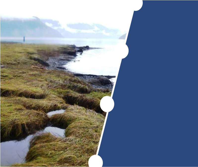
Cover photo courtesy of Rob Hajdú – Canadian Environmental Assessment Agency, 2016
© Her Majesty the Queen in Right of Canada, represented by the Minister of the Environment and Climate Change.
Catalogue No: En106-162/2017E-PDF
ISBN: 978-0-660-23725-1
This document has been issued in French under the title:
Projet de mine de granulats BURNCO: rapport d'étude approfondie
This publication may be reproduced in whole or in part for non-commercial purposes, and in any format, without change or further permission. Unless otherwise specified, you may not reproduce materials, in whole or in part, for the purpose of commercial redistribution without prior written permission from the Canadian Environmental Assessment Agency, Ottawa, Ontario K1A 0H3 or info@ceaa-acee.gc.ca.
Executive Summary
BURNCO Rock Products Ltd. is proposing to construct, operate and decommission a sand and gravel mine with marine shipping activities near McNab Creek, located on the northwest shore of Howe Sound, 22 kilometres southwest of Squamish, British Columbia (B.C.).The BURNCO Aggregate Mine Project would produce up to 1.6 million tonnes of gravel per year over a 16-year operating life.
The BURNCO Aggregate Mine Project would have a footprint of 60 hectares and consist of a gravel pit, a processing plant, a barge load-out jetty, electrical conveyors, a new small craft dock, an electrical substation, a maintenance facility, an office and would use existing on-site roads. A containment berm and flood protection dyke would be built around the pit, which would progressively fill with water and become a 30-hectare pit lake at the end of Project life. Aggregate would be shipped once every two days on a barge pulled by a tug boat from the Project site through Howe Sound to the proponent's existing facilities in Burnaby and Langley. The Project site is only accessible by boat. At closure, all Project-related marine infrastructure would be removed, and the remaining upland area impacted by the Project would be reclaimed and revegetated.
The BURNCO Aggregate Mine Project would require an authorization from Fisheries and Ocean Canada under the Fisheries Act. The requirement for this authorization triggered the need for an environmental assessment under the Canadian Environmental Assessment Act S.C. 1992, c. 37 (the former Act). Since the BURNCO Aggregate Mine Project would have a production capacity over 1 000 000 tonnes per year it is identified on the Comprehensive Study List Regulations and requires that a comprehensive study environmental assessment be conducted. The Canadian Environmental Assessment Act, 2012 (CEAA 2012) came into force on July 6, 2012, replacing the former Act. In accordance with the transition provisions of CEAA 2012, the comprehensive study for the Project is being completed under the former Act.
The BURNCO Aggregate Mine Project was subject to review under both federal and provincial environmental assessment legislation. A coordinated environmental assessment was carried out by the Canadian Environmental Assessment Agency (the Agency) and B.C.'s Environmental Assessment Office (the EAO) in consultation with a working group comprising representatives of federal, provincial, and local governments, and potentially affected Indigenous groups.
The Agency submitted this Comprehensive Study Report which meets the requirements of the former Act to the Minister of Environment and Climate Change Canada on November 16, 2017. The EAO prepared a separate report under B.C.'s Environmental Assessment Act, which will inform an environmental assessment decision by provincial ministers.
The federal Comprehensive Study Report presents the Agency's analysis and findings on whether the BURNCO Aggregate Mine Project is likely to cause significant adverse environmental effects, taking into account the implementation of mitigation measures. In preparing the federal Comprehensive Study Report, the Agency considered technical information provided by BURNCO Rock Products Ltd., expert advice from the working group, and comments provided by Indigenous groups and the public.
The Comprehensive Study Report also describes the Agency's consultation activities with Indigenous groups, and provides an assessment of the seriousness of impacts from the BURNCO Aggregate Mine Project on the Indigenous rights (i.e. asserted or established Aboriginal rights, including title) of each group.
The Agency's public consultation activities included three comment periods, some with associated information sessions, between 2012 and 2017.
The key adverse effects identified during the environmental assessment are:
- Loss of fish habitat in McNab Creek and watercourses downstream of the pit lake;
- Changes in surface water quality and quantity;
- Effects to the marine foreshore environment;
- Effects to marine wildlife including cetaceans;
- Loss of Roosevelt elk, grizzly bear and amphibian habitat;
- Effects to the area from river avulsion (loss or gain of land due to movement of the water course);
- Noise effects to nearby residents and wildlife; and
- Changes to current use of lands and resources for traditional purposes by Aboriginal persons.
Mitigation measures, to reduce or eliminate potential adverse effects, were developed during the course of the environmental assessment. Key mitigation measures include:
- Implementation of the Fish Habitat Offsetting Plan to compensate for the loss of fish habitat;
- Isolating contact water from fish habitat;
- Maintaining groundwater flows by adjusting the pit orientation;
- Using pre-cast concrete and constructing hard substrate to marine pilings for intertidal habitat;
- Installing marine piling using acoustic dampening methods and scheduling marine works when fish and cetaceans are not in the vicinity;
- Limiting vegetation clearing, conducting preclearing surveys, maintaining habitat corridors, buffers and riparian zones, and avoiding sensitive breeding periods;
- Implementation of the Roosevelt Elk Habitat Offsetting Plan to compensate for the loss of elk habitat;
- Developing amphibian compensation habitat and crossings;
- Conducting construction and operation activities during the day time;
- Maintaining natural barriers and using topography to limit acoustic disturbance;
- Application of an Access and Communication Protocol for the Squamish Nation; and
- Measures outlined above to mitigate effects to water quality, fish and fish habitat, noise, wildlife and vegetation would also mitigate some effects to current use of lands and resources for traditional purposes.
Overall, the Agency concludes that the BURNCO Aggregate Mine Project is not likely to cause significant adverse environmental effects. These conclusions were reached taking into account the implementation of mitigation measures and the EAO's proposed Environmental Assessment Certificate conditions, that would become legally-binding in the event a provincial Environmental Assessment Certificate is issued.
If the BURNCO Aggregate Mine Project proceeds, a follow-up program would be required to verify the accuracy of environmental assessment predictions and to determine the effectiveness of proposed mitigation measures. The Agency recommends that the follow-up program include monitoring of effects to the freshwater and marine environments including effects to fish and fish habitat. The EAO has also proposed a number of Environmental Assessment Certificate conditions that would require BURNCO Rock Products Ltd. to develop and implement management and monitoring plans for key adverse effects.
The Crown has a common law duty to consult Indigenous groups, and where appropriate accommodate, when it contemplates conduct that might adversely affect existing or established Aboriginal or Treaty rights. This Report discusses the Agency's assessment of the BURNCO Aggregate Mine Project's potential impacts to the Aboriginal Interests of Squamish Nation, Tsleil-Waututh Nation, Musqueam Indian Band, Stz'uminus First Nation, Cowichan Tribes, Halalt First Nation, Lake Cowichan First Nation, Lyackson First Nation, Penelakut Tribe, and Métis Nation BC.
The Agency concludes that the BURNCO Aggregate Mine Project is not likely to cause significant adverse effects to the current use of lands and resources for traditional purposes.
This federal Comprehensive Study Report is subject to a public comment period. A summary of comments received on the Report will be provided to the Minister of Environment and Climate Change Canada. The Minister will issue a decision statement that sets out her opinion as to whether, taking into account the implementation of mitigation measures that she considers appropriate, the BURNCO Aggregate Mine Project is likely to cause significant adverse environmental effects. It will also set out any mitigation measures or follow-up program that she considers appropriate after having taken into account the views of federal authorities. The environmental assessment will then be referred back to Fisheries and Oceans Canada as the responsible authority for an appropriate course of action in accordance with section 37 of the former Act.
Table of Contents
- Executive Summary
- Table of Contents
- List of Appendices
- List of Tables
- List of Figures
- Glossary
- 1 Introduction
- 2 Project Description
- 3 Scope of Environmental Assessment
- 4 Environmental Effects Assessment
- 5 Other Effects Considered
- 6 Impacts on Potential or Established Aboriginal Rights including title
- 6.1 Consultation Activities
- 6.2 Potential or Established Aboriginal Rights Including title
- 6.3 Proponent analysis of Potential Impacts on Potential or Established Aboriginal Rights Including Title
- 6.4 Mitigation and Accommodation Measures
- 6.5 Issues to Be Addressed During the Regulatory Phase
- 6.6 Issues Beyond the Scope of the Environmental Assessment
- 6.7 Views Expressed by Indigenous groups to the Agency
- 6.8 Agency Conclusions Regarding Impacts on Potential or Established Aboriginal Rights Including Title
- 7 Public Consultation
- 8 Follow-up Program
- 9 Conclusions of the Agency
- 10 References
- 11 Appendices
List of Appendices
- Appendix A: Summary of Environmental Effects and Mitigation Proposed by the Proponent
- Appendix B: Residual Environmental Effects Rating Criteria
- Appendix C: Agency's Assessment of the Significance of Residual Environmental Effects
- Appendix D: Summary of Key Concerns Raised during Consultations with Indigenous Groups
List of Tables
- Table 1 Administrative Information
- Table 2 Project Components
- Table 3 Project Activities
- Table 4 Spatial Boundaries for the Assessment of Key Valued Components
- Table 5 Summary of fish habitat loss and gain
- Table 6 Distance of Acoustic Effects from Impact Pile Driving
- Table 7 Distance of Acoustic Effects from Marine barge transportation
- Table 8 Marine large vessel increases
- Table 9 Comparison of Project GHG emissions to provincial, national and global levels
- Table 10 Selection of Public Comments on the Proponent's EIS and Summary
- Table 11 Items identified for a Follow-Up Program
List of Figures
- Figure 1: BURNCO Project Location and proposed shipping
- Figure 2: Project Development Area
- Figure 3: Mine Arrangement
- Figure 4: Processing Area and Marine Barge-Loading Facility
- Figure 5: Alternative Mine Layouts
- Figure 6: Alternative Mine Pit Sizes
- Figure 7: Freshwater fish habitat and offsetting
- Figure 8: Amphibian offsetting habitat
- Figure 9: Map of study areas for Indigenous current use of lands and resources
- Figure 10: Flood Protection Dyke and Inundation Area
Glossary
- Agency
- Canadian Environmental Assessment Agency
- B.C.
- British Columbia
- CEAA 2012
- Canadian Environmental Assessment Act, 2012
- CO2e
- carbon dioxide equivalent
- COPC
- Contaminant of Potential Concern
- dB
- Decibels
- DFO
- Fisheries and Oceans Canada
- EAO
- Environmental Assessment Office
- ECCC
- Environment and Climate Change Canada
- EIS
- Environmental Impact Statement
- FLNR
- Ministry of Forests, Lands, Natural Resource Operations and Rural Development
- former Act
- Canadian Environmental Assessment Act S.C. 1992, c. 37
- kPa
- Kilopascals
- Minister
- Minster of Environment and Climate Change Canada
- PM10
- coarse particulate matter
- PM2.5
- fine particular matter
- Project
- BURNCO Aggregate Mine Project
- proponent
- BURNCO Rock Products Limited
- Report
- Comprehensive Study Report
- SPL Peak
- Sound pressure level peak (maximum instant sound pressure in a period of time)
- SPL rms
- root mean square sound pressure level (average sound pressure in a period of time)
1 Introduction
1.1 Project Overview
BURNCO Rock Products Limited (the proponent) proposes to construct and operate the BURNCO Aggregate Mine Project (the Project), a sand and gravel mining operation located within the Lower McNab Valley on the northwest shore of Howe Sound, approximately 22 kilometres southwest from Squamish, British Columbia (Figure 1).
The Project would be developed on a 70-hectare parcel of land in the southern portion of a 320-hectare property owned by the proponent. The Project would have a footprint of 60 hectares and consist of a 30-hectare aggregate pit, a processing facility, a barge load-out jetty, electrical conveyors, a small craft dock, an electrical substation, a maintenance facility, and an office. Aggregate refers to gravel, stone, pieces of broken or crushed rocks, sand and shale used as construction material to build roads, homes, and commercial, industrial, and public infrastructure. The aggregate resource of the mine is projected to be 20 million tonnes of sand and gravel. The Project would operate for 16 years at an expected average production capacity of 1 million tonnes per year, with a maximum production capacity of 1.6 million tonnes per year.
The product would be shipped by barge from the Project site to the proponent's existing facilities in Vancouver's Lower Mainland. Currently these facilities receive product by barge from aggregate deposits located on Vancouver Island. If approved the proponent would shift its current shipping activities to the Project site, rather than increase the number of barges in the Strait of Georgia.
The Project was formerly known as the McNab Valley Aggregate Project; in late 2011 the proponent changed the Project to its current name.
Contact information for the proponent and the Agency is available in Table 1
|
BURNCO Project |
BURNCO Rock Products Ltd. 20395 102B Avenue Langley, BC V1M 3H1 Attention: Derek Holmes, Property Manager, B.C. Aggregate Division E-mail:Derek.holmes@BURNCO.com |
|
Federal Environmental Assessment |
Canadian Environmental Assessment Agency 701 West Georgia St, Suite 410 Vancouver, BC V7Y 1C6 |
|
Canadian Environmental Assessment Registry: Reference number: 54754 |
Figure 1: BURNCO Project Location and proposed shipping
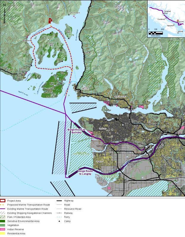
Source: BURNCO Project Final Environmental Impact Statement, Golder Associates Ltd.
1.2 Environmental Assessment Process
The Canadian Environmental Assessment Act S.C. 1992, c.37 (former Act) applied to federal authorities that contemplated certain actions or decisions that would enable a project to proceed in whole or in part. Such actions or decisions included authorizations, permits, and approvals.
An environmental assessment of the Project is required under the former Act because Fisheries and Oceans Canada may issue an authorization in relation to the Project under the Fisheries Act.
The environmental assessment commenced on April 27, 2010 and is being conducted under the former Act, as per the transitional provisions of the Canadian Environmental Assessment Act, 2012 (CEAA 2012), which came into force on July 6, 2012. This Project requires a Comprehensive Study-type environmental assessment because it meets the following description of a project as described in section 18(i) of the Comprehensive Study List Regulations of the former Act: "The proposed construction, decommissioning or abandonment or an expansion that would result in an increase in production capacity of more than 35 per cent of a stone quarry or gravel or sand pit with a production capacity of 1 000 000 t/a or more".
The Canadian Environmental Assessment Agency (the Agency) is responsible for the conduct of the comprehensive study for the Project.
1.2.1 Cooperative Environmental Assessment Process
The Project is also a reviewable project under B.C.'s Environmental Assessment Act. Information related to the provincial environmental assessment process is available on the B.C. Environmental Assessment Office's website: (http://a100.gov.bc.ca/appsdata/epic/html/deploy/epic_project_home_355.html).
The governments of Canada and British Columbia conducted the environmental assessment cooperatively. This cooperative process included a working group comprised of federal and provincial technical officials, Indigenous groups and local government agencies. Each government will make its own decision on the Project in accordance with its own legislation.
1.2.2 Purpose of the Comprehensive Study Report
This Report presents a summary of the Agency's analysis of the potential environmental effects of the Project and sets out the Agency's conclusions on whether the Project is likely to cause significant adverse environmental effects, after taking into account the implementation of mitigation measures. The analysis was informed by consultation with Indigenous groups, Fisheries and Oceans Canada, Transport Canada, Natural Resources Canada, Environment and Climate Change Canada, Health Canada, provincial and local government experts, and the public. The findings and conclusions are based on the Agency's review of the proponent's Environmental Impact Statement (EIS) and associated documents prepared by the proponent and consideration of the input received during consultation.
The federal Minister of Environment and Climate Change Canada (the Minister) will consider this Report and comments received from Indigenous groups and the public when issuing an environmental assessment Decision Statement in relation to the Project. The Minister may request additional information or require that public concerns be addressed further before issuing the Decision Statement. The Minister will refer the Project to Fisheries and Oceans Canada following the environmental assessment decision to allow the department to take the appropriate course of action in accordance with section 37 of the former Act.
2 Project Description
2.1 Scope of the Project
The scope of the Project for the purpose of the Comprehensive Study includes all physical works and activities associated with the construction, operation, maintenance, decommissioning, reclamation, and closure of the Project.
2.2 Project Components and Activities
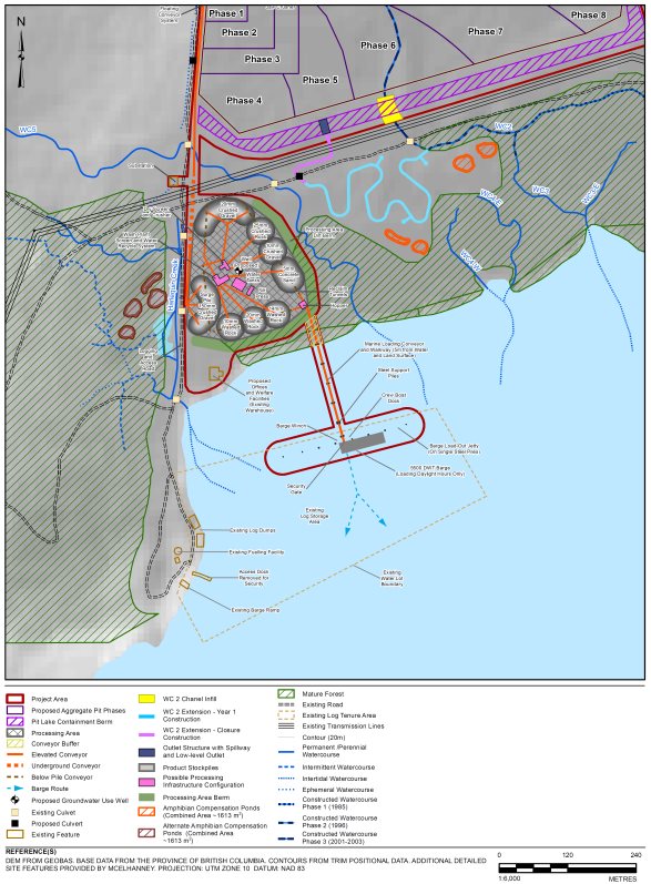
Project components and activities are listed in Tables 2 and 3. The location of the Project, the mine arrangement, and the processing area and marine barge-loading facility are illustrated in Figures 1, 2 and 3 respectively.
| Component | Purpose/Detail |
|---|---|
|
Open Pit |
The pit from which the aggregate would be mined would be approximately 30 hectares in size (500 metres wide and 600 metres long). The aggregate would be excavated to form a wetted pit that would naturally fill with groundwater to form a pit lake. The maximum excavated depth would be 35 metres below the current surface unless adjustments are required to avoid adverse environmental effects. |
|
Aggregate Processing Area |
Processing would involve screening the aggregate to remove fines and to separate different material sizes. Oversized materials would be crushed. The aggregate material would be washed and dewatered to remove silt. |
|
Stockpiles and Storage Areas |
The processed sand and gravel products would be moved and sorted by aggregate size into stockpiles. The stockpiles would range between 21,200 tonnes and 55,500 tonnes and 4,638 metres square to 6,587 square metres in area depending on the product. |
|
Conveyors |
A floating conveyor system would move crushed rock from the pit lake to the processing area. The conveyors would move material to the primary crusher if required, and then to each stockpile. A marine loading conveyor would transport material to the barge load-out jetty. Conveyors would be powered by electricity. |
|
Access |
Access to the Project site would be provided by private water taxi from Horseshoe Bay and Gibsons. Transportation on the Project site would use existing roads: one currently used for logging runs along the west side of the project area into McNab Valley, one that runs beneath the existing hydroelectric lines at the south end of the proposed pit, and one that runs along the north end of the proposed pit. |
|
Berms and Dykes |
An existing berm constructed by Fisheries and Oceans Canada in 2001 that runs parallel to the north portion of McNab Creek would be repurposed into the flood protection dyke. In addition, the pit lake containment berm, 7.2 metres high and 20 to 25 metres wide would be built along the south perimeter of the proposed pit. The flood protection dyke and the pit lake containment berm would connect to cover the eastern flank of the Project along McNab Creek. |
|
Fines Storage Area |
A fines storage area would be used for the disposal of fine particle materials and silt recovered after processing. It would be developed adjacent to the northern portion of the flood protection dyke. |
|
Soil Storage Areas |
Soil not suitable for the construction of the flood protection dyke would be gathered and placed in two temporary stockpiles adjacent to the fines storage area. One stockpile would be for topsoil and the other would be for subsoil. The stockpiles would be covered or vegetated for erosion control. |
|
On-Site Structures |
On-site structures would include an administration and communications building, a first aid facility with helipad, a caretaker's cabin, a floating small craft dock attached to the jetty, and a pump room for intake freshwater distribution and fire-fighting. |
|
Electrical substation |
An electrical substation would be constructed to convert power from an existing 138 kilovolt transmission line across the south perimeter of the proposed pit to 575 volts. An outdoor switchyard, an electric building, and connecting transmission line less than 100 metres would also be constructed. |
|
Barge Load-Out Jetty |
The barge load-out jetty would accommodate up to two barges, each up to 5,500 deadweight tonnes, and would include a covered electric conveyor, and docking facilities. |
| Activities and Physical Works | Description |
|---|---|
|
Site Preparation |
|
|
Construction and Installation of Project Facilities |
|
|
Aggregate Pit Mining |
|
|
Aggregate Stockpiling |
|
|
Aggregate Processing |
|
|
Mine Waste and Water Management |
|
|
Transportation |
|
|
Operational and Maintenance Activities |
|
|
Decommissioning, Reclamation, and Closure |
|
|
Post-closure |
|
Figure 2: Project Development Area
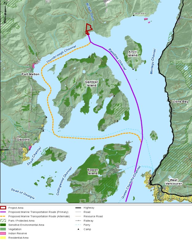
Source: BURNCO Project Final Environmental Impact Statement, Golder Associates Ltd.
Figure 3: Mine Arrangement

Source: BURNCO Project Final Environmental Impact Statement, Golder Associates Ltd.
Figure 4: Processing Area and Marine Barge-Loading Facility
Source: BURNCO Project Final Environmental Impact Statement, Golder Associates Ltd.
2.3 Project Schedule
Construction would begin after the Project has received government approvals and permits which the proponent anticipates obtaining in 2018 and would take up to 2 years. The operation phase would be for 16 years. Project reclamation would be ongoing during operation. At the end of operation a final reclamation and closure process would begin and would take one year to complete.
3 Scope of Environmental Assessment
Scoping of the environmental assessment was undertaken with B.C.'s Environmental Assessment Office to focus the assessment on valued components and relevant factors. This process was also used to establish the temporal and spatial boundaries for the assessment. The scope of the assessment is described in the Application Information Requirements/Environmental Impact Statement Guidelines for the BURNCO Aggregate Project, which was finalized in December 2014.
3.1 Factors to be Considered
The following factors were considered as part of the Comprehensive Study pursuant to subsections 16(1) and 16(2) of the former Act:
- the environmental effects of the Project, including the environmental effects of malfunctions or accidents that may occur in connection with the Project and any cumulative environmental effects that are likely to result from the Project in combination with other projects or activities that have been or will be carried out;
- the significance of the environmental effects referenced above;
- comments from the public that are received in accordance with the former Act and regulations;
- measures that are technically and economically feasible and that would mitigate any significant adverse environmental effects of the Project;
- the purpose of the Project;
- alternative means of carrying out the Project that are technically and economically feasible and the environmental effects of any such alternative means;
- the need for, and the requirements of, any follow-up program in respect of the Project, and
- the capacity of renewable resources that are likely to be significantly affected by the Project to meet present and future needs.
In accordance with paragraph 16(1)(e) of the former Act, the Agency also required an assessment of the need for the Project, and an evaluation of alternatives to the Project.
Subsection 79(2) of the Species at Risk Act requires responsible authorities to identify the adverse effects of the Project on species listed in Schedule 1 of the Species at Risk Act, and the critical habitat for these species and, if the Project is carried out, ensure that measures are taken to avoid or lessen those effects and to monitor them. The measures must be consistent with any applicable recovery strategies and action plans. The environmental assessment considered effects on species listed on Schedule 1 of the Species at Risk Act (Appendix A). It also considered impacts on species listed by the Committee on the Status of Endangered Wildlife in Canada.
3.2 Scope of the Factors Considered and Spatial and Temporal Boundaries
The environmental assessment focused on aspects of the natural and human environments that have particular value or significance and may be affected by the Project. These are referred to as valued components. Valued components assessed by the proponent are listed in Table 3.1. The proponent defined local and regional assessment areas as follows:
- The local study area is the maximum area within which project-related environmental effects can be measured with a reasonable degree of accuracy and confidence.
- The regional study area includes the local study area and areas within which the Project's environmental effects may overlap or interact with the environmental effects of other projects or activities.
| Valued Component | Local study Area Spatial Boundary | Regional study Area Spatial Boundary |
|---|---|---|
|
Freshwater Environment (Section 4.2) |
|
|
|
Marine Environment (Section 4.3) |
|
|
|
Terrestrial Environment (Section 4.4) |
|
|
|
Greenhouse Gas Emissions (Section 4.5) |
|
|
|
Human Health (Section 4.6) |
|
|
|
Current Use of Land and Resources for Traditional Purposes by Aboriginal Persons (Section 4.7) |
|
|
Temporal boundaries for the assessment were defined based on the timing and duration of Project activities and the nature of the potential Project interactions with each valued component. The temporal boundaries included all project phases: construction, operation, decommissioning, reclamation, and post-closure.
This Report examines the six key valued components identified in Table 4. The predicted environmental effects of the Project on each component are summarized and presented with the Agency's conclusions about the likely significance of environmental effects, taking into account the implementation of mitigation measures.
3.3 Need for and Purpose of the Project
The proponent stated that the need for the Project is to supply growing demand for aggregate on B.C.'s south coast. The purpose of the Project is to supply the proponent's need to competitively meet projected demands for aggregate since the available resource from its existing sources is low.
3.4 Alternatives to the Project
The former Act requires consideration of alternatives to a project. The proponent identified two alternatives to the Project. The first alternative was to "do nothing". If the Project is not carried out, the biophysical environment would remain unchanged, but the need for and purpose of the Project would not be realized. The proponent currently sources aggregate material from three locations in British Columbia for its operations: Port McNeil, Jervis Inlet, and Sechelt. If the proponent does not build the Project, it would continue to source aggregate from these locations until it was no longer available or economically feasible.
The second option considered is "alternative suppliers of aggregate material" where the proponent would seek to find new suppliers to meet the needs of its operations. The proponent reviewed thirty potential alternative suppliers and concluded there was uncertainty with the ability to acquire aggregate material from these suppliers during times of increased demand, and no ability to control the quality and price of the material. The proponent states that securing a BURNCO-owned supply is important to ensure being competitive in the market. Due to the risks and limitations associated with using existing suppliers in the market, this alternative was not considered further.
The proponent maintains that proceeding with the Project as proposed in the near-term is the preferred alternative.
3.5 Alternative Means of Carrying Out the Project
The former Act requires consideration of technically and economically feasible alternative means of carrying out a project, and the environmental effects of those alternative means.
3.5.1 Alternative Project Locations
The proponent considered two potential locations for the Project: McNab Creek and Treat Creek. The site at Treat Creek is approximately 47 kilometres northwest of McNab Creek, and 14 kilometres northeast of the Earls Cove ferry terminal in Jervis Inlet. McNab Creek was identified as the preferred option due to economic and technical reasons. Unlike the location at Treat Creek, the McNab Creek site is owned by BURNCO, the transportation costs are less due to the proximity of the site to the proponent's operations, and the site has proven high quality aggregate reserves, making it the preferred alternative location.
Views Expressed
In a letter submitted to the proponent on June 16, 2010, Fisheries and Oceans Canada requested a relocation or redesign of the Project. Fisheries and Oceans Canada determined that the Project, as proposed at that time, could have significant adverse environmental effects to fish and fish habitat in McNab Creek. Fisheries and Oceans Canada was concerned about the removal of freshwater fish habitat, potential adverse effects on natural groundwater channels in the foreshore area of McNab Creek, effects to southern resident killer whales, and valuable habitat within Howe Sound. Between 2010 and 2016 the proponent revised various project components to address these issues. This report assesses the environmental effects of the Project as described in the proponent's August 2016 Environmental Impact Statement (EIS).
During public comment periods and at information sessions members of the public requested that alternative locations for the Project be re-considered. The public was concerned about effects to recreational activities, tourism, and the environmental health of Howe Sound. The proponent responded that appropriate plans will be implemented to mitigate the effects to fish, wildlife, marine mammals, recreation and tourism. These plans include a Fisheries Habitat Protection and Mitigation Plan, an Air Quality and Dust Control Plan, a Noise Management Plan, a Marine Transportation Management Plan, and a Reclamation and Effective Closure Plan. The proponent also indicated that it designed the site layout so that it was possible to incorporate natural screening by retaining trees as buffers to reduce visual impacts (Figure 3).
3.5.2 Alternative Transportation Options
The proponent considered road, marine, and rail transportation options. Marine transportation was identified as the preferred option as it would be more cost-effective, and less infrastructure would be needed. Road transportation would have larger environmental and social effects, and rail transportation would not be as cost-effective and technically feasible as marine transportation. Both road and rail transportation would likely result in environmental effects as a result of requiring a new right-of-way.
Views Expressed
The public requested the proponent consider the greenhouse gas emissions produced by the three alternative methods of transportation. The proponent responded that rail and road transportation options would have similar greenhouse gas emissions as the marine transportation option, but significantly higher emissions for constructing the necessary infrastructure. The barge traffic associated with the Project would be replacing current barge traffic from aggregate suppliers in Port McNeill, Vancouver Island. The proponent stated that the distance between the Project and the BURNCO facilities in Burnaby and Langley is shorter than the distance between the current suppliers in Port McNeil and the BURNCO facilities. This reduction in distance would result in fewer greenhouse gas emissions.
3.5.3 Alternative Mine Layouts
Three alternative mine layout options were considered as highlighted in Figure 4. The first alternative (Area 1) encompasses a plot to the south and west of McNab Creek. The second alternative (Area 2) encompasses Area 1 and two additional mine plots on a slope, west of Harlequin Creek. The third alternative (Area 3) encompasses Area 1 and includes a mine plot north of McNab Creek.
Initial studies identified that Area 1 contained proven deposits of aggregate, would have environmental effects that could be mitigated, and was the most technically feasible. As such, it was determined to be the preferred option. Deposits in Area 2 were determined to be technically and economically infeasible since the operation would be constrained by Harlequin Creek and steep slopes. Area 3 is less technically feasible and cost effective since McNab Creek would bisect the site causing access and transportation challenges, and risks related to bank stability of McNab Creek. Areas 2 and 3 would also potentially result in additional environmental effects.
For the proponent's preferred option (Area 1) two pit sizes were considered: a large pit and a small pit (Figure 5). The large pit would require 20 years to excavate and would result in greater economic gain, however was expected to result in more adverse environmental effects since the extent of the pit would be closer to McNab Creek. A smaller pit that would require 16 years to excavate would result in less economic gain; however it was chosen to minimize overall environmental effects.
Views Expressed
Fisheries and Oceans Canada (DFO) raised concerns regarding the loss of the groundwater channel that was constructed as habitat offsetting for another project due to the proposed mine layout. This channel provides spawning and rearing habitat for coho, chum and pink salmon, and cutthroat trout. Additionally, DFO was concerned that the proposed mine layout would change the temperature, flow and hydrology profiles of the groundwater-fed channels running adjacent to McNab Creek which could have an adverse effect on fish productivity by affecting coho rearing habitat and chum spawning habitat. The proponent responded that contingency offsetting habitat could be constructed in Harlequin Creek to mitigate the loss of chum and coho salmon productivity. It also stated that there would be plans to ensure effects to freshwater fish are mitigated, such as the Fisheries Habitat Protection and Mitigation Plan and a Reclamation and Effective Closure Plan.
Figure 5: Alternative Mine Layouts

Source: BURNCO Project Final Environmental Impact Statement, Golder Associates Ltd.
Figure 6: Alternative Mine Pit Sizes

Source: BURNCO Project Environmental Impact Statement, Golder Associates Ltd.
3.5.4 Alternative Processing and Marine Loading Options
The proponent considered three alternative processing options: installing a processing plant in the southeastern corner of the project site, installing a processing plant in the southwestern corner of the site, and offsite processing. Processing the aggregate material off-site was determined by the proponent to not be economically feasible due to high transportation costs. The southwestern corner for the processing area was identified as the preferred on-site option because it would have fewer environmental effects since the area is already cleared, be more economically feasible due to the lower installation costs, and be more socially acceptable because it is further from the residences near McNab Creek.
The proponent considered two alternative locations for the marine barge-loading facility: the existing log dump in the southwestern corner of the project site or to the east of the existing log dump. The existing log dump was identified as the preferred option because it would have fewer environmental effects since it would not require dredging, be more economically feasible since it would be closer to the processing area, and be more socially acceptable because it is further from the residences near McNab Creek.
Views Expressed
The public expressed concern over the location of the marine barge-loading facility in terms of its impacts to recreation and tourism in the area. The public indicated that either option for the marine barge-loading facility could cause visual, noise, and safety concerns for people who use the area for boating, fishing, diving, canoeing, kayaking, paddle boarding, and sailing. The proponent responded that appropriate mitigation measures would be undertaken to prevent any visual, noise, air quality and safety concerns. It conducted a Visual Effects Assessment to show what the Project would look like from various locations around Howe Sound. The proponent also agreed to avoid operations during the night, and minimize lighting to what is required for safety purposes. A Marine Transportation Management Plan would be implemented to ensure safe shipping practices and mitigate any accidents in relation to the marine barge-loading facility and barge traffic.
3.5.5 Agency Analysis and Conclusion
The Agency reviewed the rationale and methods for selecting preferred alternative means, including taking into account the environmental effects of the alternatives, and is satisfied that the proponent adequately considered technically and economically feasible alternative means of carrying out the Project for the purposes of the former Act.
4 Environmental Effects Assessment
4.1 Approach to Environmental Effects Assessment
The Agency, in collaboration with federal departments, identified and assessed the potential adverse environmental effects of the Project on the basis of:
- the proponent's EIS and associated information (e.g. appendices, technical documents, responses to information requests);
- information obtained during public and Indigenous consultations and the proponent's responses to comments received;
- comments from federal and provincial government agencies and the proponent's responses to those comments; and
- mitigation and follow-up requirements the Agency considers necessary.
Sections 4.2 to 4.7 of this Report discuss the potential adverse environmental effects of the Project in relation to key valued components. These sections are organized as follows:
- Proponent's Assessment of Environmental Effects and Proposed Mitigation – a description of the proponent's assessment of the potential effects of the Project and of associated cumulative effects is presented.
- Views Expressed – a summary of key issues raised by Indigenous groups, the public, and government is presented in conjunction with the proponent's responses.
- Agency Analysis and Conclusions – the Agency's analysis of residual effects of the Project on each valued component is presented in conjunction with its conclusion on the significance of the environmental effects of the Project, taking into account the implementation of mitigation measures. The determination of the significance of residual effects is based on the methodology set out in the Reference Guide: Determining Whether a Project is Likely to Cause Significant Adverse Environmental Effects and includes consideration of criteria such as magnitude, geographic extent, duration, frequency, reversibility, and ecological and cultural context. Follow-up requirements deemed necessary by the Agency are also specified.
Environmental Assessment Methods
In its EIS and associated documents, the proponent described the existing environmental (baseline) conditions and the Project. The environmental effects of the Project were predicted taking into account criteria including:
- direction – the ultimate long-term trend of the environmental effect (i.e. positive or adverse);
- magnitude— the amount of change in a measurable parameter or variable relative to existing (baseline) conditions;
- geographic extent—the area where an environmental effect of a defined magnitude occurs;
- frequency – the number of times during the Project or a specific project phase or activity that an environmental effect might occur (e.g. one time or multiple times) in a specified time period;
- duration – the period of time required until the valued component returns to its baseline condition or environmental effects can no longer be measured or otherwise perceived (e.g. short-term, mid-term, long-term, or permanent);
- reversibility – the likelihood that a measurable parameter will recover from an environmental effect, including through active management techniques; and
- ecological/socioeconomic context – the general characteristics of the area in which the Project is located, as indicated by past and existing levels of human activity.
The proponent proposed measures to avoid or mitigate the adverse environmental effects of the Project.
The Agency evaluated the measures proposed by the proponent to determine the residual effects (Appendix A). Criteria for significance in relation to each valued component were then developed (Appendix B) and the Agency assessed the significance of the residual effects (Appendix C).
The Agency also assessed the potential cumulative effects of the Project that would be likely to occur on valued components for which a residual effect was identified, after the implementation of mitigation measures. The cumulative effects assessment considered past, present and reasonably foreseeable projects in the Regional Study Area. This includes the Woodfibre LNG Project near Squamish, B.C. and the Box Canyon Hydroelectric Project up McNab Valley.
4.2 Freshwater Environment
The Agency focused its assessment of effects to the freshwater environment on loss and alteration of fish habitat, changes in surface water quality, and changes in water quantity. The proponent's assessment of the baseline environment provided an understanding of the current status of fish and fish habitat in the area, including water quality and flow. After considering the potential effects of the Project, the proponent's proposed mitigation strategies, and the views expressed by federal authorities, Indigenous groups and the public, the Agency has concluded that the Project is not likely to cause significant adverse effects to the freshwater environment.
Description of baseline freshwater environment
The Project would be located in the lower portions of the McNab Creek watershed. The creek is approximately 12 kilometres long and is flanked by steep, mountainous terrain. It flows towards the Project from the north and travels around the northern and eastern perimeters of the proposed site before draining into Howe Sound. The project site is a porous gravel deposit located on a flat valley floor. The freshwater environment is complex with water flowing into the site from several sources, the main one being McNab Creek which provides groundwater that filters through the gravel deposit towards Howe Sound. Other sources include several small, ephemeral unnamed watercourses that flow onto the project site from the west. Harlequin Creek runs along the southwestern perimeter of the proposed processing area, bypasses the project site and flows into Howe Sound.
Flow within McNab Creek is highly variable between seasons. In summer months the lower portion of the creek can appear to dry-up, consisting of isolated pools only connected by subsurface water. In autumn and spring when there is heavy rainfall the creek becomes broad and wider.
The influx of surface and groundwater onto the Project area results in a high water table. Water flows south, leaving the project site via five unnamed watercourses, numbered one through five. The five unnamed watercourses are fed year-round by the groundwater that constantly seeps through the gravel deposit from McNab Creek and the surrounding area.
Watercourse 2 was created by Fisheries and Oceans Canada to compensate for effects to fish and fish habitat from unrelated industrial activities. Its width at the upstream end depends on the amount of groundwater flowing in from McNab Creek. When McNab Creek flows are low Watercourse 2 becomes narrower and shallower as there is less groundwater flowing in. In autumn and spring, when there is increased rainfall, flow in McNab Creek increases. During these high-flow periods some of the additional water from McNab Creek percolates through the gravel deposit into Watercourse 2. As a result more groundwater emerges from the gravel deposit and Watercourse 2 becomes deeper and wider.
All five downstream watercourses, McNab Creek and Harlequin Creek are fish-bearing and currently support coho, chum and pink salmon, and cutthroat trout and sculpin.
4.2.1 Proponent's Assessment of Effects and Proposed Mitigation
Effects of freshwater habitat loss
The proponent conducted the following studies to assess effects from fish habitat loss in the freshwater environment:
- fish habitat surveys from 2009 to 2013;
- fish habitat mapping, and foreshore and intertidal mapping; and
- fish use, spawner data from 2009 – 2011, supplemented with spawner surveys from 2012 – 2016.
Development of the aggregate pit would result in the loss of Upper Watercourse 2 upstream of the existing road and hydroelectric line and loss of surface flow in Lower Watercourse 2 (Figure 3). Watercourse 2 provides spawning habitat for chum and coho salmon, and 42 spawners were observed using the area in November 2016. Pink salmon have also been observed using the habitat. Cutthroat trout use both the upper and lower portions of Watercourse 2. There are limited data on cutthroat trout spawning activity because the study design targeted salmon species. In the absence of conducting an assessment to determine the presence of cutthroat trout the proponent conservatively assumed that cutthroat trout use all of Watercourse 2 for spawning. Both instream and riparian habitat would be lost from pit development.
Figure 7: Freshwater fish habitat and offsetting
Source: BURNCO Project Environmental Impact Statement, Golder Associates Ltd.
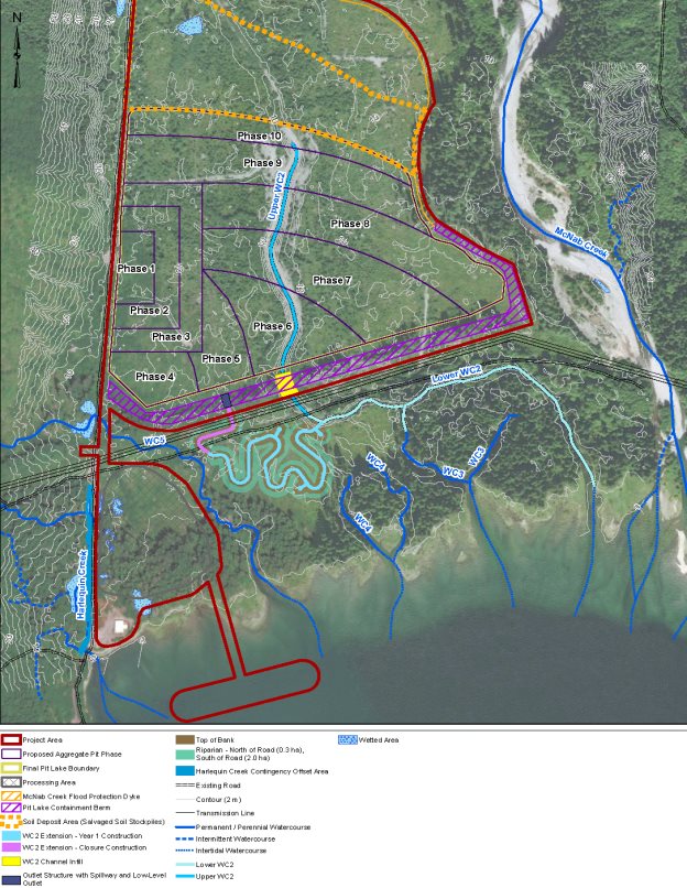
The key mitigation measure to offset for the loss of Upper Watercourse 2 is the construction of new habitat that would extend Watercourse 2 to the west (Table 5 and Figure 7). This habitat would be constructed prior to Project operation to ensure that when Upper Watercourse 2 is removed there would be established and functional rearing habitat available as a replacement. The proponent also proposed to construct new habitat in Harlequin Creek as a contingency option in the event monitoring of the Watercourse 2 Extension indicates that it is not functioning as intended. Approximately 325 metres of Harlequin Creek is available for enhancement.
| Instream habitat (metres square) | Riparian habitat (metres square) | |
|---|---|---|
|
Loss - Upper WC 2 (impacted) |
- 3,187 |
- 1,501 |
|
Loss – Lower WC 2 (surface area loss due to reduced flows) |
- 125 |
n/a |
|
Gain - WC 2 Extension (Constructed) |
+ 4,034 |
+ 22,710 |
|
Net change |
+ 722 |
+ 21,209 |
With the Project resulting in an overall increase in fish habitat, the proponent determined that no residual adverse environmental effects from habitat loss would occur.
Effects of changes to surface water quality
The proponent conducted the following studies to assess effects from changes to surface water quality in the freshwater environment:
- Hydrological modelling to create computer simulations to predict groundwater flow, particulate matter and heat transfer, and estimate the change in wetted area of McNab Creek and Watercourses 1-5;
- Water quality modelling to estimate the monthly change in contaminants and ions in Watercourses 1-5 from pit lake water, precipitation, groundwater, and seepage from excavated materials; and
- Aquatic health assessment to evaluate the potential effect of adverse water quality to fish habitat at various locations in McNab Creek and Watercourses 1-5.
The development of the aggregate pit may affect water quality in all five unnamed watercourses downstream of the pit. The pit would continually fill with groundwater as sand and gravel is excavated because of the high water table on the project site, and surface water from precipitation. Over time the pit would become a lake; the water would be turbid from the suspended solids mobilized during the mining process. Water currently filters naturally through the gravel deposit from McNab Creek and the mountainside. Likewise, the water from the pit lake would continue to seep through the porous gravel, and flow into the downstream watercourses.
The proponent's assessment suggests that most of the turbidity from the mining process would settle to the bottom of the pit lake, and that the gravel barrier beneath the containment berm proposed between the pit lake and unnamed Watercourses 1-5 would act as a filter and remove the suspended solids. The water quality in all watercourses, with the exception of aluminum, is predicted to be below all thresholds listed in the Canadian Water Quality Guidelines for the Protection of Aquatic Life [1]. Due to the nature of the gravel deposit, the watercourses have high baseline levels of total and dissolved aluminum, and the contribution of additional aluminum from the Project is expected to be negligible.
Water quality may also be affected by increases in suspended sediments as a result of erosion and runoff of disturbed soils. Sediment-laden water can adversely affect fish productivity, feeding and growth. To reduce erosion, the proponent proposes to plant native vegetation and use erosion control measures such as mulch spread over disturbed soils to prevent sediment from mobilizing. If any sediment is mobilized, measures such as silt fencing would be used to capture and redirect the turbid water away from fish-bearing watercourses toward established vegetation that would act as a filter.
Some of the infrastructure of the Project would be constructed from concrete. Water that comes in contact with uncured cement, a component of concrete, can become alkaline and deteriorate surface water quality. To limit the likelihood of this effect, the proponent proposes to use pre-cast concrete when possible.
Fish are susceptible to changes in water temperature, particularly during egg incubation and early life stages. Groundwater temperature tends to be more stable than surface water temperature because it is insulated from seasonal air temperature variation. Since the pit lake would be exposed the water that normally flows as cool groundwater could exhibit a wider range of temperature variation. Consequently the water entering Watercourses 1-5 downstream of the pit would be warmer during the summer and early autumn because those watercourses would be mostly fed by groundwater percolating from the pit lake.
The temperature of water on the surface of a lake can become warmer or cooler, depending on the season, than the water near the bottom of the lake, creating two distinct zones. If surface water from the pit flowed downstream it may degrade fish habitat water quality by altering the temperature of the watercourse. The proponent intends to mitigate temperature variations and limit surface water from flowing into Watercourses 1-5 by building a containment berm. The berm would promote cooler water from the deep, bottom layer to percolate through the gravel into Watercourses 1-5. Surface water would not be completely eliminated from percolating downstream but the proponent predicted that changes in the temperature of the water in Watercourses 1-5 would still be within the range suitable for aquatic life. The proponent determined that no residual adverse environmental effects to surface water quality would occur.
Effects of changes to freshwater quantity
The proponent conducted the following studies to assess effects from changes to water quantity in the freshwater environment:
- Drilling multiple groundwater wells and using a piezometer to develop a baseline of the level of water in the gravel deposit at various times of the year;
- Hydrological and hydraulic modelling to map flow and direction of groundwater between McNab Creek, the gravel deposit and Watercourses 1-5; and
- Numerical hydrogeological modelling to understand the relationship between groundwater flow and surface water flow.
The water in Watercourses 1 – 5, including the existing spawning habitat in Upper Watercourse 2, comes from McNab Creek which flows underground at the northern end of the Project and filters as groundwater through the gravel. There is an existing, stable balance of water flowing from McNab Creek on to the project site and the Project would alter that balance.
As gravel is removed, the pit would become a zone of low water pressure that would draw water from McNab Creek, potentially reducing downstream flows. The pit would then fill with water to become a lake. The containment berm would ensure that the elevation of the pit lake is above the elevation of McNab Creek and Watercourses 1-5 to create a zone of high water pressure. The shifting balance of water pressure, from low to high, would affect the quantity of water in McNab Creek and in Watercourses 1-5. McNab Creek and Watercourses 1-5 could potentially lose water as gravel is excavated during the operation phase, or potentially gain water when the pit lake is at maximum capacity.
The proponent states that it will be able to maintain the flow balance by controlling the pace and extent of mining. It intends to monitor water levels in groundwater wells, which would indicate the volume of water flowing into the gravel deposit from McNab Creek. If water levels in the groundwater wells begin to drop, the proponent intends to alter the orientation and depth of the pit, and the amount of sand and gravel it removes until the system balances. Seasonal changes are included in the predictions and, during low flow periods in the summer, the proponent would remove less gravel daily because the pit would fill more slowly. At the end of project life when the pit lake would be at its maximum size, the predicted average annual flows in McNab Creek are expected to be 1% greater than they are currently.
The proponent would implement the following key mitigation measures:
- follow the Fisheries Habitat Offsetting Plan which includes building offsetting habitat to maintain and enhance fisheries productivity;
- build the containment berm and flood protection dyke;
- establish monitoring triggers and alter the pace of excavation and orientation of the pit as required to maintain the elevation of the water in the pit lake and ensure that flow in McNab Creek and Watercourses 1-5 is within existing baseline conditions;
- revegetate disturbed areas;
- adhere to the proposed design elements including limiting the extent of the mining operation, avoiding downstream watercourses and ensuring no flow reductions occur in McNab Creek;
- isolate work areas;
- apply erosion and sediment control measures such as protecting or limiting soil disturbance, and installing silt fencing; and
- adhere to the Material Storage, Handling and Waste Management Plan.
The proponent states that it would respond to any deficiencies in the effectiveness of the fish habitat offsetting as required. It would employ adaptive management and implement additional mitigation as necessary to remain in compliance with environmental legislation. As a result of the proposed mitigation measures no residual adverse environmental effects from habitat loss or degradation were predicted.
Cumulative freshwater environmental effects
The proponent did not conduct a cumulative effects assessment on the freshwater environment since the predicted residual effects to fish and fish habitat were considered to be negligible after offsetting and other mitigation measures, and did not warrant being carried forward for the purposes of a cumulative effects assessment.
Monitoring and Follow-Up
The proponent proposed to include the following components in a monitoring and follow-up program for the Project:
- Fish and Fish Habitat Monitoring Plan;
- Groundwater Monitoring Plan;
- Surface Water Quality Monitoring Plan; and
- Aquatic Resources Monitoring Plan.
Monitoring would help verify the predictions of the assessment of effects to the freshwater environment and the effectiveness of the mitigation measures that would be applied. A component of the Fish and Fish Habitat Monitoring Plan would be to ensure that the habitat created as part of the fisheries offsetting functions as intended, includes characteristics that would provide spawning and rearing habitat, and balances the losses in fisheries productivity. Further, the Groundwater Monitoring Plan would confirm that any changes in flow to McNab Creek do not exceed current existing baseline conditions, and that the Surface Water Quality Monitoring Plan would confirm if the Project was degrading the water quality in fish habitat in Watercourse 1-5 downstream of the pit lake. Follow-up measures are intended to identify the occurrence of adverse effects on the freshwater environment and will be developed during the regulatory compliance monitoring phase.
4.2.2 Views expressed to the Agency
In June 2010 Fisheries and Oceans Canada (DFO) sent a letter to the proponent noting the need to relocate or redesign the Project as it was proposed given the potential effects on the freshwater environment in McNab Creek, and on the loss of Upper Watercourse 2 as habitat for fish. The proponent considered this letter that the potential effects highlighted by DFO when preparing its EIS.
Fish Habitat Offsetting
McNab Creek is considered a rare watercourse in the region since its mouth is an unrestricted alluvial fan. The lack of human influence on the creek allows it to flow and meander in a natural way from year to year. According to DFO, the lack of human influence on McNab Creek contributes to the value of the watercourse as fish habitat, and there are few remaining examples of unrestricted alluvial fans in the region. Further, DFO was not in favour of removing Upper Watercourse 2 because it had originally been constructed as spawning habitat to compensate for effects from other unrelated past activities, and the watercourse had become a functional part of the McNab Creek watershed.
In the EIS the proponent proposed a fish habitat offsetting plan to address the loss of Upper Watercourse 2. DFO however, noted that the plan proposed to replace spawning habitat with rearing habitat.
DFO, along with the B.C.'s Ministry of Forests, Lands, Natural Resource Operations and Rural Development (FLNR), expressed concern that the lower portion of Watercourse 2 may be functionally lost by removing its upper portion. This is because Upper Watercourse 2 currently provides cold, fast-moving, oxygenated water to Lower Watercourse 2. Fish, particularly juvenile salmon, tend to have high survival and fitness rates in cold water that has high levels of dissolved oxygen. The removal of Upper Watercourse 2 could turn Lower Watercourse 2 into a stagnant watercourse with warmer water that contains less oxygen.
The offsetting habitat would be built as an upstream extension of the existing functional spawning habitat (Figure 7). Federal and provincial departments were both concerned that the offsetting habitat may impact Lower Watercourse 2. This would be due to the shallow gradient of the proposed channel extension that would connect to Lower Watercourse 2, which may prevent maintaining adequate flow to sustain the current fish populations. As a result of the limited flow and low gradient, the amount of dissolved oxygen may decrease and the temperature of the water in summer months may increase. In addition, DFO and FLNR were concerned that the proposed offsetting habitat would not function as intended if the water was warmer, and flowed slower than predicted.
The proponent acknowledged that its proposed fish habitat offsetting plan would not replace the spawning habitat that would be lost, but rather provide conditions suitable for spawning. This is because the area is relatively flat so it would not be possible to build an extension to Watercourse 2 that could have water flowing any faster. The proponent asserted that the majority of the spawning in Watercourse 2 occurred in its lower reaches, which it felt would not be affected. The proponent also indicated that 3 312 metres square of lost wetted area would be replaced with 4 034 metres square of new wetted area, and 1 501 metres square of lost riparian habitat with 22 710 metres square of new riparian habitat, so there would be an overall gain in fish habitat.
The proponent added riparian vegetation to the habitat replacement approach proposed in the offsetting plan to help regulate increases in water temperature. Since however, the temperature of the water would primarily be affected by the pit lake the additional vegetation is only expected to result in a modest reduction in water temperature. Because of the limited size of the offsetting area there were few options to increase the flow by increasing the gradient in the constructed habitat so that it would support spawning. The proponent disagreed that flows would be reduced in Lower Watercourse 2 noting that the creation of the pit lake would cause hydrostatic pressure that would lead to increased groundwater upwelling into Lower Watercourse 2.
DFO concluded that, while the offsetting plan would create a larger area of fish habitat than would be impacted, the offsetting habitat may not be sufficient to balance the losses in fisheries productivity. DFO requested that the proponent provide additional offsetting to ensure that these losses are balanced. In response, the proponent proposed a contingency plan to enhance a 325-metre length of Harlequin Creek. DFO reviewed this option and agreed that, if this additional offsetting is included in the plan rather than only being constructed as a contingency, effects to fish habitat, including the loss of habitat within Watercourse 2 can be offset. The final offsetting details, including the amount of habitat required to fully offset effects to fish habitat, would be addressed during the regulatory phase following the environmental assessment.
Water Quality
ECCC raised concerns pertaining to the potential for streamflow increases within McNab Creek, leading to increased erosion of the banks of McNab Creek and associated Total Suspended Solids levels. ECCC recommended that the long-term surface water quality monitoring plan include Total Suspended Solids monitoring in McNab Creek. The proponent responded that the Surface Water Quality Monitoring Plan would include the monitoring of Total Suspended and Dissolved Solids in McNab Creek, which addressed ECCC's concern.
Water Quantity
DFO, ECCC and FLNR also expressed concerns regarding potential water quantity effects to fish habitat in McNab Creek and the proponent's intention to monitor those effects by measuring the level of water in groundwater wells. While monitoring these wells would give an indication of changes in flows of water on to the Project site, they would only be an indirect indicator, and would not give a full assessment if any effects to fish habitat were occurring. In addition DFO indicated that relying entirely on a groundwater model was insufficient to monitor whether the Project would cause effects to fish habitat in McNab Creek as a result of flow reduction.
The proponent responded that it could avoid effects to McNab Creek by mining less gravel from the site. The extent and depth of the proposed pit was reduced to prevent it from encroaching on the creek, and acting as a sink that would draw water from the creek beyond existing baseline conditions. It also indicated that, due to the increased water pressure caused by the elevation of the pit lake, the Project would be more likely to cause slight increases in the volume of water in McNab Creek, thereby improving the quality of fish habitat.
The Agency requested that the proponent conduct additional monitoring during the life of the Project to verify that adverse effects to McNab Creek would not occur. The proponent proposed to monitor water levels directly, in addition to flow velocity, to give more meaningful data. The Agency and DFO agreed that using this approach to supplement the groundwater monitoring plan was appropriate.
Saltwater Intrusion
Saltwater intrusion was identified as a risk by provincial authorities. By digging into a porous gravel deposit adjacent to the marine environment it is possible that saltwater could flow subsurface into the pit lake during high tides. Consequently, water that flowed from the pit lake back into Watercourses 1-5 could raise the salinity of the freshwater environment. The proponent responded that, because the level of the pit lake will always be maintained above sea level, the hydrostatic pressure from the pit lake would prevent saltwater from flowing beneath the gravel deposit and into the pit lake. The Agency agrees that maintaining the level of the pit lake above sea level would limit the risk of saltwater intrusion.
Additional Concerns
The concerns related to effects within McNab Creek, the loss of fish habitat in Upper Watercourse 2, and the effects to Lower Watercourse 2 were echoed by the Squamish Nation, Tsleil-Waututh Nation and the public over the course of the environmental assessment.
Squamish Nation expressed concerns regarding the potential effects to fish and fish habitat in the area, however indicated that it is conditionally supportive that the mitigation measures proposed would reduce effects to a level acceptable to Squamish Nation for the purposes of the environmental assessment. The proponent has conducted on-going consultation with the Squamish Nation, and committed to continuing to do so after the environmental assessment, including discussing effects to fisheries and the proposed fish habitat offsetting plan.
Tsleil-Waututh Nation expressed general concern about effects to fisheries, and observed that potential effects of the Project on Chinook salmon and trout that may use the watercourses were not characterized. The proponent acknowledged that these fish species were not included as valued components, but they felt that the proposed mitigation, including fish habitat offsetting proposed would prevent or reduce effects to them. The Tsleil-Waututh Nation also commented on the potential changes in water quantity in McNab Creek and expressed concern that the creek may be dewatered as a result of the Project. The proponent proposed a monitoring program that would track discharge in McNab Creek and other downstream watercourses. The proponent would manage stream discharge by adjusting the rate at which gravel is removed.
The public expressed the following concerns related to potential Project effects on the freshwater environment:
- Effects to McNab Creek, Harlequin Creek and the unnamed downstream watercourses;
- Loss of spawning and riparian habitat;
- Salmon stocks, the fish run in McNab Creek, and its effect on recreational fishing;
- Ensuring freshwater habitat for salmon spawning;
- Ensuring that the existing offsetting habitat continues to function as intended;
- Adequacy of the baseline data;
- Water flowing from the project that may include silt, acid, metal leaching, and sulphides;
- Loss of water evaporating from the pit lake;
- Maintaining water levels in the pit lake, McNab Creek and the downstream watercourses;
- Movement of surface and ground water; and
- Cumulative effects with Box Canyon Hydroelectric Project.
The proponent responded to these concerns by noting that the Project will not affect fish and fish habitat in McNab Creek, Harlequin Creek, and the unnamed downstream watercourses. It does not intend to reduce the quality or quantity of fish habitat in the area, and will not affect any spawning in McNab Creek. The proponent said that it will build offsetting areas that includes instream and riparian habitat, which will be built prior to operation so that it can ensure that the habitat functions as intended beyond the life of the Project.
The proponent would ensure that water leaving the Project would not have increased levels of silt, and that, after conducting geochemical testing, the release of acidic water or increasing sulphides levels is highly unlikely. Some testing indicates that there may be elevated concentrations of metals currently leaching from the project site; however analysis showed that the levels were within the parameters of the Canadian Council of Ministers of the Environment (CCME) Guidelines for the Protection of Freshwater Aquatic Life.
The proponent responded to concerns regarding the movement of surface and groundwater indicating that it will be able to maintain water levels in the pit lake using the containment berm, and that its groundwater modelling has accounted for the movement of groundwater from McNab Creek, and for loss of water through evaporation. It will be able to maintain flows in McNab Creek and downstream by progressively adjusting the depth and orientation of the pit, which will in turn alter the depth of the pit lake. Federal and provincial regulators agree that the approach was sound, so long as there was sufficient monitoring on McNab Creek, downstream watercourses and groundwater well to verify the predictions.
4.2.3 Agency Analysis and Conclusion
The Project would result in the loss of 3 312 metres square of instream habitat and 1 501 metres square of riparian habitat. The proposed offset would provide 4 034 metres square of instream habitat and 22 710 metres square of riparian habitat. After offsetting habitat is constructed the Project would result in a net gain of 722 metres square of wetted fish habitat and 21 209 metres square of riparian habitat. An additional 2 744 metres square area has been identified within which to develop contingency instream habitat in Harlequin Creek if monitoring results indicate that the Watercourse 2 extension offset (including any required adaptive management adjustments) is not functioning as intended. The Agency agrees with the proponent's assessment that the residual effect from removal of habitat would be negligible.
While the proposed offsetting habitat in Watercourse 2 would have lower flow velocities and may not support spawning, there would still be opportunities for spawning in the lower portion of Watercourse 2. As a result, Watercourse 2 may become more suitable as rearing habitat for juvenile salmon that would spawn elsewhere in the watershed, such as McNab Creek.
The Agency considered the potential effects to McNab Creek from changes in flows. While it is unlikely there would be any adverse effects to fish habitat from lost flow in McNab Creek, the proponent will be required to conduct additional monitoring of flow velocities to confirm that effects to fish habitat are avoided. Nevertheless, the Agency is confident that the changes to McNab Creek flows from digging the pit would be within the range of McNab Creek's high natural flow variability.
Flows in Lower Watercourse 2 would likely fluctuate as a result of its upper half being removed for the pit lake. By building the extension to Watercourse 2 between the pit lake and Lower Watercourse 2 in advance of Upper Watercourse 2 being removed, flows in the lower reach would be maintained during the life of the Project (Figure 7). With implementation of the proposed mitigation measures, adequate monitoring and adaptive management, the proponent should be able to maintain the integrity of the watercourse over the life of the Project, and then ensure it is stabilized at closure.
Since Upper Watercourse 2 would be lost, the magnitude of the effect from fish habitat loss is considered high. The loss with respect to the overall watershed, however, is minimal because spawning habitat in McNab Creek would not be affected. Juvenile salmon could continue to use Lower Watercourse 2, and would also likely use the offsetting habitat for rearing. The loss is only expected to happen once, be confined to the local assessment area, and be reversible if the offsetting habitat functions as intended. The Agency also considers the addition of contingency offsetting habitat to be an appropriate option to ensure that serious harm to fish and fish habitat is avoided.
The magnitude of the effects to surface water quality is considered low because there are few sources that could degrade water quality, and the proponent has proposed standard best management practices to manage the effects. Incidents that would degrade water quality are expected to be infrequent, and any effects would be localized, short-term and reversible.
The magnitude of the effects to surface and groundwater quantity is considered low because changes to the flow regime are expected to be within natural variation of the system, and the extent would be local to the Project area. Since the pit lake would be a permanent feature, flow regime changes are expected to be permanent, irreversible, and continuous.
The Agency is therefore of the view that the Project is not likely to result in significant adverse environmental effects to the freshwater environment.
The Agency recommends that a follow-up program be developed to verify that the fish offsetting plan functions as intended, and that adverse effects to fish habitat in the adjacent watercourses do not occur. Further follow-up is recommended, in the form of a water management plan, to ensure that the water quality and water quantity predictions described for McNab Creek, all downstream watercourses including Lower Watercourse 2, and the pit lake are verified.
4.3 Marine Environment
The Agency focused its assessment of effects to the marine environment on marine water and sediment quality, marine benthic communities, marine fish, and marine mammals (including species at risk). An assessment of the baseline environment provided an understanding of the current status of the fish, benthic communities, and marine mammals in the area. After considering the potential effects of the Project, the proponent's proposed mitigation strategies, and the views expressed by federal authorities, Indigenous groups and the public, the Agency has concluded that the Project is not likely to cause significant adverse impacts to the marine environment.
Effects to marine migratory birds, including species at risk, are considered in Section 4.4. Effects to human health from the consumption of marine harvested foods are considered in Section 4.6.
Description of baseline marine environment
The marine barge-loading facility is within an intertidal zone comprised of sand, gravel and cobble beach that extends 150 metres from the high tide line into the ocean, with grasses in the upper intertidal zone. The seafloor has a layer of sediment and is carpeted with wood and bark debris, particularly in the western portion of the Project area due to historical log handling activities. Currently boron, zinc and copper levels as determined by the proponent exceed the Canadian Interim Sediment Quality Guidelines. At present surface water clarity is high, with low levels of suspended particulates and nitrogen. Phosphorus levels are high within the water column near the sea floor.
The foreshore of the Project area provides habitat for a number of phytoplankton and zooplankton communities, benthic species (e.g., barnacles, mussels, oysters, annelids, and crustaceans) and seaweeds (sea lettuce, rockweed, and kelp species). Fish species including staghorn sculpin, tidepool sculpin, starry flounder and shiner perch, Chinook, chum, coho, and pink salmon, as well as cutthroat trout were observed in the Local Study Area. These species like to move between Howe Sound, McNab Creek and Watercourses 1-5. Other fish species known to inhabit the Local Assessment Area, but were not observed during baseline studies include herring, eulachon, smelt, cod, flounder, halibut, lingcod, sole and various shellfish species. While present in Howe Sound, eelgrass beds, glass sponge reefs, fish spawning grounds and rockfish conservation areas were not observed within the foreshore of the Project area.
Eleven species of marine mammals are known to occur in the Local Study Area which includes the marine barging route. Five of these species are listed on Schedule 1 of the Species At Risk Act (2002): southern resident killer whale, harbour porpoise, north pacific humpback whale, grey whale, and Steller sea lion. Recovery strategies exist for the southern resident killer whale and the north pacific humpback whale. The scope of the proposed barging route, however, does not overlap with the critical habitat of any SARA-listed marine mammal species.
4.3.1 Proponent's Assessment
Effects from changes to marine water and sediment quality
Marine water and sediment quality may be affected as a result of physical disturbance, such as vessel propellers causing re-suspension of particles; release of deleterious substances from creosote; the removal, upgrade and installation of marine structures; and seepage of groundwater from the pit lake. The proponent:
- conducted a vessel wake wash analysis and propeller scour assessment to assess sediment disturbance and re-suspension caused by barge movements;
- assessed the potential for sediment re-suspension as a result of seafloor disturbance during marine structure installations; and
- conducted groundwater modelling to assess potential seepage from the pit lake into the marine environment.
The proponent committed to adhere to DFO's Best Management Practices for Pile Driving and Related Operations, DFO's Guidelines to Protect Fish and Fish Habitat from Treated Wood Used in Aquatic Environments in the Pacific Region, as well as best management practices for controlling erosion. It expects that seepage from groundwater will meet all water quality guidelines because seepage impacts in the freshwater environment upstream of the marine environment, are not expected (Section 4.2.1). To limit impacts from concrete the proponent committed to use pre-cast concrete where possible. A temporary on-site portable concrete batch plant would be used for items that could not be pre-cast offsite. All works would be conducted in a manner to prevent the release of deleterious substances into the marine environment. The proponent would monitor water quality during these activities to ensure that water quality guidelines for turbidity and suspended solids were not exceeded.
After the implementation of mitigation measures, the proponent predicted that, with the exception of phosphorus concentrations in water (which is not a nutrient known to limit algal blooms in the marine environment), Project-related effects would not result in exceedances of the CCME water and sediment quality guidelines for the protection of aquatic life. The proponent determined that no residual adverse environmental effects to marine water and sediment quality would occur.
Effects from marine habitat loss and degradation, injury and mortality
The proponent conducted the following studies to assess effects from marine habitat loss:
- studying marine water quality parameters at the site;
- characterizing the presence of fish, mobile and immobile invertebrates, algae and plankton; and
- analyzing Project interactions with fish, mobile and immobile invertebrates, algae and plankton.
Installing piles to support the marine jetty would destroy 1.1 metres square of benthic habitat in the intertidal zone, and 1.4 metres square of habitat in the subtidal zone. This activity would likely kill sedentary or slow-moving benthic invertebrates by crushing or burying them. Mobilized sediment may smother benthic fish rearing and spawning habitat, and may reduce available prey to foraging juvenile salmon.
Water quality around the piles may be degraded from increased turbidity and suspended solids as a result of in-water works. Sediment disturbance can mobilize pollutants, which could then be ingested by organisms at low trophic levels. The conveyor and jetty of the marine barge-loading facility may affect an additional 249 metres square of intertidal habitat and 46 metres square of subtidal habitat by shading from the sun.
The proponent would implement the following key mitigation measures:
- Conduct all in-water work within the window of least risk to marine/estuarine fisheries (mid-August – late-January) where feasible;
- Use piles rather than filling the entire area beneath marine structures to support them;
- Incorporate slats into the conveyor system and walkway design to reduce shading effects;
- Construct 10 metres square of hard substrate intertidal habitat attached to the pilings across the foreshore to promote recolonization;
- Position vessels and barges in a manner to minimize disturbance of propellers to benthic communities; and
- Prevent the release of deleterious substances during all phases.
As a result of the proposed mitigation measures no residual adverse environmental effects from habitat loss or degradation were predicted.
Effects from acoustic disturbance in the marine environment
The proponent conducted the following studies to assess effects from acoustic disturbance in the marine:
- literature review of acoustic impacts to fish and marine mammals at various life stages;
- analysis and modeling of the acoustic effects of Project activities to determine sound levels, how sound is transmitted in water; and
- mapping distances and locations of acoustic effects in the marine environment.
Acoustic disturbance to marine fish and marine mammals could occur as a result of impact pile driving in the construction phase and from the Project's barges.
Underwater noise from impact pile driving consists of sudden, loud bursts that may injure fish up to 6 metres from the source, and may injure marine mammals up to 86 metres from the source. Marine mammals may experience behavioral disturbances up to 1.9 kilometres from the source (Table 6). Pile driving is expected to occur in the construction phase for only a two week period, and would be scheduled within the least risk timing windows for the protection of marine and estuarine fish and fish habitat.
| Predicted Noise Level (dB)* | Injury Zone from source | Injury Threshold (dB)* | Behavioural Disturbance Zone from source | Behavioural disturbance threshold (dB)* | |
|---|---|---|---|---|---|
|
Marine Fish |
207 (SPL Peak) 194 SPL rms at 10 metres |
6 metres |
210 SPL Peak |
N/A |
N/A |
|
Cetaceans (whales) |
86 metres |
180 SPL rms |
1.9 kilometres |
160 SPL rms for impulsive noise |
|
|
Pinnipeds (seals and sea lions) |
18 metres |
190 SPL rms |
1.9 kilometres |
160 SPL rms) for impulsive noise |
*Noise levels in water are measured using sound pressure, and are converted to Sound Pressure Level (SPL). Measurements are reported micropascals (dB re1 μPa). SPL Peak is the maximum instant sound pressure level in a period of time. SPL rms is the average sound pressure level in a period of time
Underwater noise from tug boat-assisted barges is predicted to cause behavioral disturbances to marine mammals up to 2,154 metres from the source (Table 7). These disturbances would occur during the operational life of the Project, when on average one barge would travel through Howe Sound each way every two days for 16 years.
| Predicted Noise Level (dB)* | Injury Zone from source | Injury Threshold (dB)* | Behavioural Disturbance Zone from source | Behavioural disturbance threshold (dB)* | |
|---|---|---|---|---|---|
|
Marine Fish |
170 SPL rms at 1 metre |
No threshold exceedance |
170 SPL rms |
N/A |
N/A |
|
Cetaceans (whales) |
No threshold exceedance |
180 SPL rms |
2154 metres |
120 SPL rms for non-pulsive noise |
|
|
Pinnipeds (seals and sea lions) |
No threshold exceedance |
190 SPL rms |
2154 metres |
120 SPL rms for non-pulsive noise |
*Noise levels in water are measured using sound pressure, and are converted to Sound Pressure Level (SPL). Measurements are reported micropascals (dB re1 μPa). SPL Peak is the maximum instant sound pressure level in a period of time. SPL rms is the average sound pressure level in a period of time
In order to reduce potential acoustic effects to marine fish and mammals, the proponent would implement the following key mitigation measures:
- conduct in-water works (excluding barge use) that may generate noise outside of sensitive fisheries times of year and peak seasonal marine mammal observance periods;
- implement a ramp-up procedure where the noise level would slowly increase to discourage nearby individuals from approaching to a distance that would harm them;
- avoid conducting multiple noise-generating activities concurrently;
- use bubble curtains or a vibratory hammer rather than an impact hammer if sound levels exceed 30 kPa at a distance of 10 metres from the source;
- use dedicated observers to conduct scans for marine mammals and fish (e.g. visible schools of herring) prior to and during pile driving activities; and
- delay pile driving if a marine mammal or school of fish are spotted within the established marine mammal safety zone.
The proponent predicted residual adverse environmental effects to marine mammals and fish from acoustic disturbance following the implementation of mitigation measures, and indicated that they would not be significant. While moderate in magnitude, the proponent considered the effects to marine fish from acoustic disturbance of pile driving to be negligible because they would be localized, short in duration, infrequent, and would affect a resilient population. The proponent considered injury effects from acoustic disturbance of pile driving to marine mammals to be negligible since the mitigation is known to be effective, and the duration of the effect to be short term. Behavioural effects to marine mammals were predicted by the proponent to be likely but not significant because, while barge loading and transit would occur for the life of the Project, with moderate magnitude and regional extent, the proponent predicted that the effects to be fully reversible.
Effects from vessel strikes in the marine environment
The proponent considered the likelihood of a collision between a barge and a marine mammal to be low. Small vessels travelling greater than 13 knots pose the greatest threat of collision [2]. Given the size of the barges (80 metres) and the speed at which they would be travelling (approximately six knots), the proponent noted that vessel strikes would be unlikely as marine mammals would have ample time to avoid the vessels.
In order to reduce potential effects to marine mammals from a collision, the proponent would implement the following mitigation measures:
- barges would maintain a consistent course and a speed of six knots while in established shipping lanes;
- the tug boat operator would continually monitor the course of the vessel for signs of any nearby marine mammals and attempt to remain at least 100 metres from any sightings; and
- vessel speed would be reduced if a marine mammal approached within 100 metres. If appropriate the vessel would stop and wait for the mammal to move at least 100 metres away before resuming its normal speed.
No residual adverse environmental effects as a result of vessel strikes were predicted.
Marine Species At Risk
The proponent reported that southern resident killer whale, harbor porpoise, humpback whale, grey whale, and Steller sea lion, are likely to occur in the marine Local Study Area. As discussed above, marine mammal monitoring would be conducted, and project activities would be adjusted to ensure project-related effects on species at risk are minimized to the extent possible.
Cumulative marine environmental effects
The proponent stated that behavioral disturbance of marine mammals from acoustic disturbances had the potential to interact with other projects and activities to result in a cumulative effect. The Project would require that barges make 182 round trips (364 transits each way) from McNab Creek to the proponent's facilities in Vancouver's Lower Mainland, which would be roughly one barge every two days. The most noticeable change in large vessel traffic as a result of the Project's barge transits would be a 36% increase in in Ramillies Channel. Thornbrough Channel would be used occasionally as an alternate route and since it has higher existing levels of large vessel traffic it would see a 2.5% increase. Overall the increase in large vessel traffic in Howe Sound would increase by 3% (Table 8).
| Waterway | Existing Large Vessels | % increase in marine traffic from the Project |
|---|---|---|
|
Ramillies Channel (at 80% usage) |
843 |
36 |
|
Thornbrough Channel (at 20% usage) |
3270 |
2.5 |
|
Howe Sound |
12,909 |
3 |
Projected underwater acoustic disturbance from the Woodfibre LNG Project was assessed as part of the cumulative effects assessment on marine mammals. The Woodfibre LNG Project would have 40 LNG carrier visits per year (resulting in 80 transits), travelling along a segment of the BURNCO transportation route. The marine mammal behavioral disturbance radius around these LNG carriers would be 4.6 kilometres.
In order to ensure that no cumulative acoustic effects occur between Project vessels and Woodfibre LNG carriers, the proponent indicated that its barges would not transit the same waters at the same time as LNG carriers. Therefore, the noise disturbance fields will not overlap, and no cumulative effects to marine mammals were predicted. It intends to coordinate with other vessels using Howe Sound by following the Marine Communications and Traffic Services for commercial shipping.
Monitoring and Follow-Up
The proponent proposed to include the following components in a monitoring and follow-up program for the Project:
- Fish and fish habitat Monitoring Plan;
- Groundwater Monitoring Plan;
- Surface Water quality Monitoring Plan;
- Aquatic Resources Monitoring Plan; and
- Marine Transportation Management Plan.
The monitoring would be used to verify the predictions of the assessment and the effectiveness of the mitigation measures that would be applied. A component of the fish and fish habitat monitoring plan would be used to determine whether the habitat created as part of the Fish Habitat Offsetting Plan functioned as intended. Further, the groundwater monitoring plan would include measures to confirm that any changes in flow to McNab Creek and Watercourses 1-5 were within natural variation, and the surface water quality monitoring plan would include measures to confirm the Project was not degrading the water quality in fish habitat downstream of the pit lake.
The proponent proposed to include the following components in a monitoring and follow-up program for the Project:
- groundwater quality monitoring downstream of the pit lake;
- surface water quality monitoring downstream of the pit lake;
- pile construction and monitoring plan to address sediment release and acoustic disturbances; and
- a Marine Transportation Management Plan to ensure that vessel to ensure that its large vessel transits do not overlap with other large vessel transits.
Monitoring would be used to verify the predictions of the assessment of effects to the marine environment and the effectiveness of the mitigation measures that would be applied. Follow-up measures will identify occurrence of adverse effects on the marine environment. Should water quality be poorer than predicted, the proponent has committed to undertaking adaptive management to address groundwater seepage issues.
4.3.2 Views Expressed to the Agency
DFO sent a letter on June 16, 2010 expressing concern that the proposed marine barge-loading facility has the potential to adversely affect marine fish habitat and marine mammals, including southern resident killer whales.
Upon reviewing the EIS, DFO requested additional information regarding the potential effects or risks associated with increased groundwater flow and associated hydrostatic pressure on marine fish and fish habitat, and erosion of the foreshore marsh habitat used for rearing by juvenile salmon. DFO inquired as to whether there would be any changes in where and how groundwater would enter the marine environment, in order to understand mixing and potential effects on fish habitat in the estuary. The proponent advised that groundwater would mainly upwell into the streams to the south of the proposed pit lake. The proponent agreed to monitor the saltwater marsh and shoreline for signs of erosion by incorporating aerial photography into its monitoring program and collect images at low tide before the operation phase and at years one, two, five, and ten.
DFO, Tsleil-Waututh Nation and members of the public, including the Vancouver Aquarium, expressed concerns about potential effects of Project vessels mobilizing sediment from the seafloor that could smother glass sponge reefs known to inhabit Howe Sound. The proponent responded that in its underwater surveys glass sponge reefs were not found in the shallow areas around the marine barge-loading facility where propeller scour would most likely mobilize sediment. Studies showed that all sponge reefs in the Local and Regional Assessment Areas are 20 metres below sea level or deeper. At this depth water velocities from barge propellers were modelled to be the same as natural tidal currents, so were not likely to mobilize sediments that would cause smothering.
Tsleil-Waututh Nation commented that it believes that all projects should result in positive outcomes and requested that the proponent improve the subtidal area by removing the woody debris currently on the sea floor from the historic log dump. It expressed concern regarding the underwater noise thresholds used to determine harm to fish and marine mammals, and requested that underwater noise be monitored during construction. The proponent stated that the submerged woody debris would not be removed as the area is still an active log sorting area and that debris would likely continue to accumulate. Regarding underwater noise, the proponent advised that acoustic injury thresholds were based on the best available science, and that a qualified environmental monitor would be on-site throughout the construction phase to monitor underwater sound and pressure levels from activities like impact pile driving.
Cowichan Tribes expressed general concerns regarding spill contamination, spillage risk and prevention, marine traffic, and impact to fisheries.
The public expressed concern regarding:
- destruction/degradation of the McNab estuary;
- ecosystem effects to Howe Sound and marine and aquatic species;
- effects to marine fisheries, including salmon, anchovy, herring, crab, oysters, shellfish, and shrimp;
- effects to marine mammals, including orcas, whales and dolphins, as a result of marine transportation, underwater noise, and changes in prey availability;
- cumulative effects of industrial development in Howe Sound, which has only recently begun to recover from historical industrial activities;
- vessel wake resulting in shoreline erosion and dock damage;
- gravel dust and particulates deposition in the marine environment;
- sediment effects to benthic communities;
- disturbance and destruction of foreshore habitat, including due to light, noise, changes in freshwater and tidal water quality, sediment effects, and propeller scour;
- lack of baseline data on aquatic species at risk;
- insufficient baseline data to adequately characterize baseline conditions for marine and anadromous fish species, resulting in the inability to conduct quantitative monitoring of project effects; and
- underwater noise.
The proponent responded to these concerns by noting that the Project would limit the destruction of fish and fish habitat in the McNab estuary and that the area would be returned to its original state at the end of the Project. It indicated that the Project would not have any ecosystem effects on Howe Sound, and there would be no residual effects to fisheries. The proponent also responded to the concern regarding effects to marine mammals indicating that it had mitigation measures in place to prevent collisions with mammals, and that barge speeds were slow enough to enable vessels and animals to alter course or stop. The slow speed of the barges was also the reason for why effects from underwater noise and effects from vessel wake causing shoreline erosion and dock damage would be minimal.
The proponent responded to concerns regarding increased dust deposition indicating that the majority of the works would be conducted in wet conditions, and that the gravel conveyor system would be covered. It responded to concerns about noise and light indicating that since the operations would not occur at night sleep disturbances were unlikely. It would also maintain a buffer of trees around the mining area to limit daytime noise propagating across the water. The proponent also acknowledged that cumulative effects in Howe Sound were possible, but that its comparative contribution to other industrial activity in the area was minimal.
4.3.3 Agency Analysis and Conclusion
The Project would destroy 2.5 square metres of benthic habitat, which would result in the mortality of individual benthic organisms. Due to the localized, very limited spatial extent of this effect, and the application of mitigation, the Agency agrees with the proponent's assessment that the residual effect from habitat destruction would be negligible.
Habitat degradation would occur as a result of shading effects, and decreases in marine water and sediment quality due to sediment re-suspension. Shading effects would be localized beneath the conveyor and habitat would be lost due to pile installation. Building hard substrate areas at the base of the pile would, however, allow organisms to recolonize the immediate area. Marine water and sediment quality would meet all Canadian Water and Sediment Quality Guidelines with the exception of phosphorus; however, since it is not the not the primary nutrient that causes algal blooms in the marine environment, this exceedance would not have an effect on marine habitat. As such, the Agency agrees with the proponent's assessment that these residual effects would be negligible.
Marine fish and marine mammals would be affected by underwater acoustic disturbance associated with the Project. The Agency recognizes that impact pile driving activities in the construction phase would exceed fish injury thresholds up to a distance of six metres from the source [3], and marine mammal injury thresholds up to a distance of 86 metres from the source.
Whereas it is reasonable to expect that adult fish may move to other areas to avoid the zone of acoustic disturbance associated with impact pile driving, juvenile or less mobile fish inhabiting the foreshore may not be able to relocate, and therefore may experience injury and/or mortality. Research on behavioural disturbance to fish is limited, however, the Project activities may result in directional avoidance, causing fish to potentially move away from suitable habitat or alter their natural movements. Other potential noise effects to fish include startle responses, increased stress, increased susceptibility to predation, hearing loss, and injury.
Marine mammals are expected to experience behavioural disturbance up to 1.9 kilometres from the source of impact pile driving activities, and 2.2 kilometres from the source of moving barges along the marine transportation corridor. Behavioural disturbance could result in changes to marine mammal communication, navigation, and prey detection.
The magnitude of the effect of injury to marine fish is considered moderate, but local in extent, short term in duration, multiple irregular in frequency, and fully reversible to irreversible depending on actual effects to individual organisms. The magnitude of the effect resulting from injury to marine mammals is considered to be moderate, regional in extent, short-term, would be rare, and fully reversible to irreversible depending on actual effects to the population.
Marine mammals currently inhabit Howe Sound despite high levels of recreational, commercial and industrial vessel activity. They have recently re-colonized Howe Sound, likely in response to long-term water quality remediation efforts. Given that five species of marine mammals in the Regional Assessment Area are listed under the Species At Risk Act, the context is considered to be sensitive. The magnitude of behavioural disturbance to marine mammals is considered moderate, regional in extent, short-term in duration, reversible, and would occur every two days for the life of the Project.
Mitigation measures should ensure that injury to marine mammals is not likely. Some behavioural disturbance is expected; however, fish and mammals should be able to temporarily move away from the area until the noise event has passed. Whereas vessels from the Woodfibre LNG Project have the potential to interact cumulatively with the barges from the BURNCO Project, the barges intend to avoid transiting Howe Sound at the same time as the LNG carriers which would limit cumulative acoustic effects from occurring.
Taking into account the mitigation measures proposed by the proponent, the Agency is of the view that the Project is not likely to result in significant adverse environmental effects to the marine environment, including species at risk.
4.4 Terrestrial Environment
The Agency focused its assessment of effects to the terrestrial environment on birds, Roosevelt elk, grizzly bear, amphibians, and species at risk. After considering the potential effects of the Project, the proponent's proposed mitigation strategies, and views expressed by federal authorities, Indigenous groups and the public, the Agency has concluded that the Project is not likely to cause significant adverse effects to the terrestrial environment.
Description of Baseline Environment
The Project is proposed within the McNab Creek Watershed, which consists of low elevation, coastal habitat flanked by steep, mountainous terrain. The vegetation in the watershed is dominated by coniferous trees such as western hemlock, cedar, and fir. Since portions of the project footprint have been impacted by past logging activity the vegetation at the project site primarily consists of alder, and maple trees and shrubs in various stages of regrowth.
4.4.1 Proponent's Assessment
The proponent found 97 wildlife species inhabiting the Local Study Area and conducted an effects assessment on Roosevelt elk, and grizzly bear and select species of birds and amphibians. The proponent determined how wildlife used the project area by:
- conducting habitat suitability modelling for birds, Roosevelt elk and grizzly bear;
- completing breeding surveys for birds in 2012 and amphibians in 2012 and 2014; and
- using remote cameras to record Roosevelt elk and grizzly bear activity from 2009 to 2012.
The proponent selected five bird species to examine: northern goshawk; marbled murrelet; band-tailed pigeon; western screech owl; and common nighthawk. These species were chosen as they share similar life histories with all other bird species in the project area and are considered the most sensitive to impacts. Marine birds are also considered in this section of the Report because they inhabit the coastal foreshore environment.
Three amphibian species, the western toad, the northern red-legged frog and the coastal tailed frog were chosen to represent all other amphibian species as they are also considered the most sensitive to effects from the Project in that location.
The proponent used remote cameras to evaluate wildlife presence in the project area for three years. The project site is used as overwintering habitat by Roosevelt elk due to its low elevation relative to the mountainous terrain up McNab Valley. Grizzly bear were not observed during data collection but may use the area since the project site is part of the Squamish-Lillooet Grizzly Bear Population Unit [4]. The proponent also determined that the project site has habitat features considered to be high-quality for grizzly bear such as the proximity to a salmon-bearing water course and vegetation composition.
After determining how wildlife uses the project area, the proponent assessed the effects to these species from habitat loss, barriers to movement and mortality.
Effects from Habitat Loss
The proponent intends to clear and grub vegetation from approximately 60 hectares of terrestrial habitat and revegetate approximately 30 hectares at the end of the life of the Project. The remaining 30 hectares, the area of the pit lake, would permanently alter the ecological function of the site and cannot be revegetated. Clearing and grubbing vegetation can degrade adjacent habitat, cause sensory disturbance during its removal or eliminate the habitat altogether. Project operations can also cause sensory disturbance from noise.
Nesting and foraging habitat for the band-tailed pigeon (four hectares for nesting), western screech-owl (four hectares for nesting, 44 hectares for foraging) and common nighthawk (one hectare total for nesting and foraging) would be lost due to vegetation clearing after the implementation of mitigation measures. All birds, including marbled murrelet and northern goshawk, are sensitive to disturbance from noise and would likely avoid the project area during construction and operation. They exhibit behavioural changes at 60 to 80 decibels and the noise from gravel removal, gravel loading, tug boat operations and pile driving is expected to reach 80, 109, 111 and 129 decibels respectively.
The proponent intends to clear vegetation from 51 hectares of Roosevelt elk habitat and 49 hectares of grizzly bear habitat. Noise causing sensory disturbance during construction and operation would impact the two species at an additional 500 to 800 metres beyond the project site. As such, the habitat loss for Roosevelt elk and grizzly bear may be as much as 128 hectares and 269 hectares respectively.
Seven amphibian breeding ponds were found near or adjacent to the project area (Figure 8). Two of those ponds comprise 22% (0.12 hectares) of the habitat in the Local Study Area and would be removed. The Project may also fragment habitat by disturbing the areas between the ponds that amphibians use for migration, and alter amphibian behaviour due to noise causing sensory disturbance.
Figure 8: Amphibian offsetting habitat

Source: BURNCO Project Environmental Impact Statement, Golder Associates Ltd.
To mitigate effects from habitat loss, the proponent would implement the following key mitigation measures:
- use already disturbed areas;
- minimize vegetation clearing through project design;
- avoid vegetation clearing during sensitive breeding periods;
- conduct pre-clearing surveys to avoid clearing when wildlife are present;
- limit construction to daytime hours, and minimize noise by implementing a variety of best management practices discussed in Section 4.6;
- avoid fragmenting habitat by maintaining vegetation linkages, riparian and buffers zones;
- construct and install nest boxes for western screech-owls in nearby forest habitat;
- construct habitat compensation in consultation with Indigenous groups at an offsite location for Roosevelt elk;
- build four shallow ponds that would provide 0.125 hectares of amphibian breeding habitat; and
- progressively reclaim and revegetate disturbed areas.
The proponent predicted that, following the implementation of mitigation measures, residual effects to birds and amphibians from habitat loss were unlikely because the amount of suitable habitat disturbed was negligible, and most effects were reversible following reclamation. The proponent also predicted that there would likely be residual effects to Roosevelt elk and grizzly bear, but that these would be minor and not significant because the project area makes up only a small portion of the available habitat in the region.
Effects from barriers to movement
The proponent evaluated the potential effects of barriers to movement for all terrestrial wildlife species, but concluded that Roosevelt elk and amphibians were the species that might be affected.
Barriers to Roosevelt elk movement could occur as the animals migrate to their winter habitat at lower elevations, which includes the Project area, between mid-December and mid-March. Roosevelt elk would no longer be able to move directly between habitats north of the Project area and those to the south along the marine foreshore. Barriers to amphibian movement could be caused by project infrastructure being built between habitats. In particular red-legged frogs and western toads occupy different habitat types for breeding and rearing. With existing breeding ponds being adjacent to the proposed processing area, individuals may be prevented from accessing terrestrial rearing habitat on the other side of the project area. These barriers to movement can reduce the amount of habitat available to Roosevelt elk and amphibians, increase mortality by requiring them to migrate across roads, increase foraging effort, and restrict them from accessing breeding sites.
Measures that would mitigate effects of barriers to movement are similar to those proposed to mitigate effects from habitat loss. In addition the proponent proposed to:
- avoid clearing vegetation in Roosevelt elk habitat during winter months;
- construct amphibian passageways;
- store equipment in designated areas to avoid obstructing wildlife movements; and
- bury and elevate linear features such as the conveyor system.
The proponent predicted that the likelihood of effects to elk movement would be high, but that the mitigation would be effective in enabling individuals to move to different habitat types which they occupy depending on the season. It also predicted that, since amphibian passageways are a common practice used to successfully maintain amphibian migration in other industries, that this mitigation would also be effective. As such the proponent predicted that the residual effects to Roosevelt elk and amphibian movement would be negligible in magnitude and fully reversible. The proponent predicted that effects from barriers to Roosevelt elk and amphibian movement would not cause significant adverse residual effects.
Effects from Mortality
The proponent determined that the Project could result in increased mortality to birds, Roosevelt elk, grizzly bears and amphibians as a result of vegetation clearing that could crush individuals or nests and from collisions with project vehicles and infrastructure such as power lines. Improvements to the marine jetty and road could increase public access to the project area and up McNab Valley which could result in increased bird and elk hunting, and grizzly bear poaching. The proponent also indicated that Roosevelt elk may drown in the pit lake if shoreline slopes are too steep or the gravel slope is too loose for the animals to gain a foothold and safely climb out. Finally, the proponent indicated that, even though grizzly bear were not found in during data collection, individuals that migrate into the Local Study Area may habituate to humans and become nuisance bears, in which case they would need to be destroyed if they posed a threat to human safety.
The proponent would mitigate mortality with the follow measures:
- control traffic speeds on roadways in the project area and limit road travel at night;
- prohibit non-project vessels and vehicles using the marine jetty and road to prevent poaching or unauthorized hunting;
- prohibit employees from hunting in the Local Study Area;
- implement wildlife chance encounter procedures, staff education and wildlife mortality reporting program;
- install educational signage;
- conduct pre-clearing surveys to ensure wildlife are not in the area when clearing is to occur;
- implement wildlife chance encounter procedures and educate staff;
- taper and stabilize the slopes of the pit lake so that Roosevelt elk would be able to easily walk up the shoreline;
- store or remove potential wildlife attractants;
- install fencing along roadways prevent Roosevelt elk and amphibians from using the roads;
- construct amphibian crossings; and
- salvage and relocate amphibians from ponds that will be removed prior to clearing.
As a result of the implementation of the above mitigation measures, the proponent predicted that a residual adverse environmental effect to birds from mortality would not occur. It also predicted that residual effects to Roosevelt elk, grizzly bear and amphibians may still occur, but that with mitigation they would not be significant.
Cumulative Environmental Effects
Roosevelt elk habitat is vast and extends far up the McNab Valley, with individuals currently migrating into multiple adjacent watersheds. The proponent predicted cumulative adverse effects to Roosevelt elk due to the loss of overwintering habitat, which may exacerbate impacts to elk habitat from other human activity in the region. The proponent concluded that, since elk could use other areas for overwintering, these cumulative effects are not expected to exceed ecological thresholds or compromise the regional population, and would not be significant.
The proponent also concluded that there may be cumulative effects from the Project to grizzly bear as a result of vehicle collisions causing mortality from existing logging activity in the Regional Study Area. The grizzly bear population is within the Squamish-Lillooet Population Unit which is 582 834 hectares, and ranges from the McNab Creek foreshore at its southern end approximately 115 kilometres north to include Clendening Provincial Park, and is flanked by Highway 99 and Jervis Inlet on its eastern and western borders. Since the population unit of 59 individuals is considered threatened by B.C.'s Ministry of Forests, Lands, Natural Resource Operations and Rural Development, the proponent concluded that any residual adverse cumulative effects from mortality would be considered significant.
The proponent predicted that the Project may result in cumulative effects to amphibians due to increased mortality from vehicle collisions. The Project is flanked by one road that is used by other companies for access to logging and hydroelectric power sites. The proponent proposed to mitigate the cumulative effects by communicating and planning with other proponents in the area on amphibian breeding times and migrations. It would report and share information about amphibian sightings, reduce vehicle speeds during sensitive periods and avoid using road while amphibians are migrating across the road. Following the implementation of mitigation, the proponent concluded that the cumulative effects are not expected to be significant.
No residual effects to birds were predicted by the proponent therefore it did not conduct a cumulative environmental effects assessment on birds.
Monitoring and Follow-Up
To determine the effectiveness of the mitigation measures meant to reduce the effects on terrestrial species the proponent proposed to include the following components in a monitoring and follow-up program for the Project:
- Wildlife Monitoring: includes annual monitoring of birds and mammals within the Local Study Area to track species presence, abundance, habitat use;
- Vegetation Monitoring: includes an evaluation of any effects to vegetation outside of the Project area, post-reclamation monitoring to assess the success of reclamation activities, and an assessment of general vegetation conditions within the mine footprint; and
- Amphibian Monitoring: includes annual monitoring of amphibians within the Local Study Area to track species presence, abundance, habitat use.
Monitoring plans for water and fisheries would supplement the monitoring for effects to wildlife, such as the water quality monitoring program will also include monitoring the water quality in constructed amphibian breeding locations
4.4.2 Views Expressed to the Agency
Environment and Climate Change Canada (ECCC) and the Tsleil-Waututh Nation noted that an effects assessment should be conducted for each species at risk observed in the Project area, and that species at risk should not be used as surrogates or indicators of larger species groups. ECCC requested that the proponent provide additional baseline studies on the common nighthawk, barn swallow, short-eared owl, olive-sided flycatcher and black swift, following standard ECCC advice and methodology. ECCC also questioned whether the marbled murrelet critical habitat identified in the EIS was based on current data and recommended that the proponent provide additional baseline studies.
The proponent responded to these concerns indicating that using species at risk as surrogates for other species was appropriate because they are more susceptible to project effects. The proponent asserted that addressing effects to the species at risk would therefore address effects to less sensitive species as well. With regard to identifying the critical habitat for all species the proponent responded that it adopted a precautionary approach when developing its methodology for the assessment. The proponent assumed that, if there was uncertainty regarding species presence or use of habitat, that the entire Local Study Area was considered high quality in the assessment. As such the effects to species were likely overestimated, and mitigation would be applied more broadly. ECCC indicated that more robust data was preferred but that this approach would be satisfactory in this case.
ECCC noted that two species of bat considered to be species at risk have the potential to occur in the Local Study Area: Keen's long-eared myotis and the little brown myotis. ECCC requested that baseline surveys with radio telemetry and acoustic monitoring be conducted to determine the presence of these species and that an effects assessments be conducted. The proponent responded that, since the Project would not remove any bat foraging habitat such as old-growth forests, no roosting habitat or hibernacula were found in the Local Study Area, and the average temperatures in the Local Study Area are too warm to support bat hibernation, bats were not likely to be found on the Project site. The proponent therefore did not conduct baseline surveys to determine bat presence. While ECCC acknowledged that the proponent 1) concluded that there are few habitat features in the Local Study Area that would support bats; 2) indicated that the Project would not operate at night, and 3) pre-emptively installed bat boxes (artificial wood boxes for roosting) throughout the project area; ECCC noted that without baseline studies, there remains some uncertainty as to the presence or absence of bats. The Agency considered ECCC's advice and, notwithstanding the confirmed presence or absence of bats, was of the opinion that adverse environmental effect were unlikely, and that the use of bat boxes would mitigate the loss of any unanticipated effects from the loss of bat habitat.
Squamish Nation commented that the Wildlife Monitoring and Follow-Up Plan was too vague to detect unanticipated effects, and requested additional monitoring commitments. It also requested to be included in discussions regarding additional mitigation that may be applied at a later date if it is determined that the Project is having an effect on wildlife. The proponent committed to incorporating Squamish Nation input into the existing Wildlife Monitoring and Follow-up Plan and that they would be consulted on any additional proposed mitigation.
The public expressed concerns regarding effects to birds, elk, bears, species at risk, and wildlife habitat. Comments related to:
- habitat destruction and degradation from creek diversions, noise, dust, light and waste;
- effects to species from changes in freshwater and marine water quality;
- effects to other species not assessed such at wolves;
- cumulative adverse effects from habitat loss and degradation in the region;
- insufficient baseline data collection;
- the inability of regulators to alter the Project if effects are greater than anticipated; and
- the economic gain against the potential effects to species at risk, wildlife, and their habitat.
The proponent responded to these concerns by indicating that habitat destruction and degradation would be limited to the greatest extent possible, and that the area would be revegetated at the end of the Project. These measures would also limit cumulative effects from habitat loss or degradation. In response to concerns regarding effects to wildlife from changes to water quality the proponent noted that changes were either unlikely, or would be within natural variation. The proponent responded to concerns that the assessment did not consider effects to certain species (for example wolves) indicating that the assessment of effects to other species like grizzly bear were a reasonable surrogate. It disagreed with assertions by the public that its baseline data collection was insufficient. Finally it stated that it developed technically and economically feasible mitigation measures that would minimize the environmental effects to wildlife and their habitat, and that there would not be a trade-off between economic gain and environmental effects.
4.4.3 Agency Analysis and Conclusions
Based on the information available, the Agency predicts that the Project would result in residual effects to birds, Roosevelt elk, grizzly bear, and amphibians from habitat loss, barriers to movement, and mortality.
Habitat Loss
The proponent proposed well-established mitigation measures to limit the effects from the loss of habitat including using previously disturbed areas, avoiding or minimizing clearing, clearing during non-sensitive periods like breeding season, and conducting pre-clearing surveys. Further, the proponent has committed to revegetate disturbed areas, and build amphibian ponds to compensate for loss. Nevertheless, vegetation removal would eliminate low-elevation overwintering habitat for Roosevelt elk, of which there is a limited amount in this mountainous region. Even though the area that would become the pit lake would be permanently modified, this loss is not expected to affect the overall populations of birds, Roosevelt elk, grizzly bear, or amphibians.
Sensory disturbance could make the habitat in and around the Project non-functional for birds, Roosevelt elk, grizzly bear, and amphibians. Grizzly bear are known to use salmon-bearing waterbodies similar to McNab Creek as food sources and there are only six salmon-bearing streams in the Regional Study Area. The adverse effects to freshwater fish habitat (Section 4.2) could therefore translate into residual effects to grizzly bear habitat. Sensory disturbance effects are expected to be limited to the mine and processing areas, be low in magnitude and occur throughout the life of the Project. The proponent has proposed mitigation measures to limit the noise, such as using electrical power instead of diesel, to keep sound level increases minimal when compared to baseline levels. Therefore, with the application of mitigation measures and, since Grizzly bear have not been recorded on site, the residual effects from habitat loss expected to be low and not significant.
Barriers to movement
Based on the information available, the Agency predicts that the Project would cause residual effects to Roosevelt elk and amphibians as a result of barriers to movement. Project infrastructure could fragment habitat and prevent Roosevelt elk from migrating from the east side of the Project along the foreshore to habitat on the west side of McNab Valley. Likewise amphibians may be prevented from moving to and from breeding ponds and terrestrial forested habitat.
The mitigation measures proposed by the proponent are expected to be effective in maintaining habitat linkages so that both Roosevelt elk and amphibians are able to migrate to different habitat type. The residual effects from barriers to movement are therefore expected to be low, and not significant.
Mortality
The Project may increase bird, Roosevelt elk, grizzly bear and amphibian mortality due to collisions with vehicles and project infrastructure such as power lines. The Project may result in increased hunting or poaching of birds, Roosevelt elk and grizzly bear. Roosevelt elk may fall into the pit lake and drown if they are unable to climb out, and grizzly bears that habituate to humans may be destroyed if they pose a safety risk. Controlling vehicle speeds, limiting vehicle use, comprehensive staff education and restricting access to hunters/poachers are expected to be effective mitigation against effects from mortality. Building shallow slopes around the pit lake should enable elk to climb out, and keeping wildlife attractants such as food waste properly stored are also anticipated to be effective mitigation. Notwithstanding the proponent's determination that the Project may cause significant adverse cumulative effects to grizzly bear from increased mortality as a result of poaching, the Agency determined that these events would be unlikely to occur.
Taking into account the mitigation measures proposed by the proponent, the Agency is of the view that the Project is not likely to result in significant adverse environmental effects to the terrestrial environment, including species at risk from habitat loss, sensory disturbance and mortality.
4.5 Greenhouse Gas Emissions
The Agency focused the assessment on the level of greenhouse gas emissions from the Project and compared them against provincial and national emissions. See Section 5.2 for an analysis on the potential effects of climate change on the Project, and Section 4.6 for an analysis of the potential effects of air emissions on human health.
The assessment of the baseline levels of greenhouse gas emissions provided an understanding of the Project's contribution to provincial and national greenhouse gas emissions levels. After considering the proponent's mitigation strategies, views expressed by federal authorities, Indigenous groups and the public, the Agency has concluded that the Project is not likely to contribute significantly to provincial and national greenhouse gas levels.
Description of Baseline Environment
Greenhouse gases are atmospheric gases that absorb and re-emit infrared radiation resulting in the warming of the lower levels of the atmosphere. Once released, these gases disperse and cause global changes to the climate. There are various types of gases which cause different greenhouse effects so, to allow for comparison, each gas is reported in units of tonnes of carbon dioxide equivalent (CO2e).
4.5.1 Proponent's Assessment
The proponent determined the level of greenhouse gas emissions by:
- calculating the types of greenhouse gases and the annual emissions levels from different Project activities; and
- comparing emissions levels with the total provincial, federal and global emissions.
All phases of Project have the potential for greenhouse gases emissions. The primary greenhouse gases that would be generated by the Project are carbon dioxide, methane, and nitrogen dioxide. The following Project activities would emit greenhouse gases:
- energy consumption for gravel extraction, conveyance, sorting and crushing;
- barge tug boats;
- vegetation clearing;
- use of fuel for onsite vehicles; and
- welding.
The primary mitigation measure proposed by the proponent to reduce greenhouse gas emissions would be to use electricity from BC Hydro for the main processing operations instead of diesel generators. In addition, emissions would be minimized by preventing idling of on-site vehicles and tug boats, minimizing vegetation clearing, and by maintaining vehicles to improve their efficiency.
After mitigation the proponent predicted that the Project would emit 5.21 kilotonnes of CO2e per year. This value was compared to provincial, national and global emissions levels (see Table 9).
| Emission category | Annual Emissions (kilotonnes of CO2e/year) | Relative Emissions* |
|---|---|---|
|
BURNCO Aggregate Mine Project |
5.21 |
100 % |
|
British Columbia Emissions (2013) |
64 000.00 |
0.0081 % |
|
Canada Emissions (2013) |
726 000.00 |
0.00072 % |
|
Global Emissions (2012) |
44 815 540.00 |
0.00001 % |
*Relative emissions describe the percent contribution of the Project compared to each emission category
The proponent concluded that after mitigation the residual emission levels were so low in magnitude that they would be negligible and not significant.
4.5.2 Views Expressed
Environment and Climate Change Canada (ECCC) requested that the proponent quantify expected greenhouse gas emissions from water taxis servicing the Project and provide the number of additional trips per day and water taxi engine size. The proponent advised that the number of water taxi roundtrips was to be one per day and the vessel engine size was small; as a result the contribution of additional greenhouse gas emissions from this activity would be negligible and would not change the outcome of the assessment.
Tsleil-Waututh Nation disagreed with the proponent's calculation of tug boat emissions, stating that they should be calculated using the entire vessel route to capture the entire effects of the Project and not just the vessel operations in the scope of the EA. The proponent responded that since there would not be any additional shipping beyond Howe Sound there would not be any additional emissions, and that assessing these effects was outside the scope of the Project. Further, the proponent indicated that there would be a net reduction in greenhouse gas emissions as a result of the Project because it would be shifting production from its facility on northern Vancouver Island to Howe Sound. This would reduce the distance travel by the tug boats by approximately 700 kilometres and therefore would reduce fossil fuel use and greenhouse gas emissions. The drop in greenhouse gas emissions as a result of the shorter travel distance was not included in the assessment as it was outside the scope of the Project.
Tsleil-Waututh Nation, Squamish-Lillooet Regional District and members of the public also raised concerns about the Project's contribution to climate change. The proponent provided information on climate trends and analyzed 30 years of historical climate data to develop models that characterized the anticipated future climate changes for the Howe Sound region from 2040 to 2069, and 2070 to 2099. The proponent determined that, due to the relatively small contribution of greenhouse gas emissions from the Project any changes in climate as a result of the emissions would not be measurable.
4.5.3 Agency Analysis and Conclusions
The Project is an aggregate mine with few sources that would emit greenhouse gases. The primary mitigation measures to minimize greenhouse gas emissions would be to limit the use of fossil fuels and instead use electricity from BC Hydro for the main processing operations.
Though small, greenhouse gas emissions would be generated continuously during operation and are considered irreversible due to the persistence of carbon dioxide in the atmosphere. The geographic extent of the emissions are considered global due to the cumulative nature of greenhouse gas emissions and their contribution to climate change.
The Agency considers the volume of greenhouse gas emissions from the Project, approximately 5.21 kilotonnes of CO2e/year during operation, to be low in magnitude compared to provincial and national greenhouse gas inventories. The predicted greenhouse gas emissions from the Project are below the current reporting requirements identified in the provincial Greenhouse Gas Reduction Targets Act, 2007 and the federal Canadian Environmental Protection Act, 1999 of 10 kilotonnes of CO2e/year and 50 kilotonnes of CO2e/year respectively. The Agency therefore concludes that the Project is not likely to contribute significantly to provincial and national greenhouse gas levels.
4.6 Human Health
The Agency focused the assessment of effects on human health on air emissions, contaminants in country foods and surface water, and noise. An assessment of the baseline environment provided an understanding of the current status of conditions that may affect human health in the area. After considering the potential effects of the Project, the proponent's proposed mitigation measures, and the views expressed by federal authorities, Indigenous groups and the public, the Agency has concluded that the Project is not likely to cause significant adverse effects to the human health .
Description of Baseline Environment
The closest community to the Project is the McNab Strata which includes 16 residences and is located roughly 400 metres east of the easternmost portion of Project site and more than 1,000 metres from the processing and stockpile area. Squamish Nation, Tsleil-Waututh Nation, Musqueam Indian Band and members of the public, including residents from Douglas Bay on Gambier Island, use the project area for traditional and recreational activities.
Contaminants of Potential Concern (COPC) are physical, chemical, biological or radiological substances which, when released into the environment, may be harmful to human health. Some potential health problems can be minor such as epiphora (watery eyes), rhinorrhea (runny nose) and skin rashes, while more severe health problems include respiratory issues, birth defects, developmental problems, cancers, kidney or liver damage. Baseline data was collected data for COPCs present in air, soil, berries, water, invertebrates (crab and mussels), and fish.
Air quality conditions were measured at three existing monitoring stations in the regional assessment area: Langdale Elementary School, Horseshoe Bay, and Squamish. Concentrations of contaminants in air were described as an average exposure expected over time; either 24 hours or one hour [5]. Particulate matter refers to particles suspended in air and are classified as either coarse (less than 10 microns, PM10) or fine (less than 2.5 microns, PM2.5). The baseline levels of particulate matter and total suspended particulates over a 24-hour period in the project area are below B.C.'s air quality criteria. Nitrogen dioxide and sulphur dioxide average concentrations over a one-hour period are also below B.C.'s air quality criteria.
Country foods, also known as traditional foods, include those foods trapped, fished, hunted, or harvested for subsistence or medicinal purposes, or obtained from recreational activities such as sport fishing and/or game hunting. These foods are gathered from the natural environment (as opposed to foods produced from agriculture) and are used for sustenance. The baseline data for the contaminants present in country foods were calculated using high consumption rates (as compared to the general Canadian population). Since humans consume berries, the proponent collected soil samples as a surrogate for vegetation/berries, given that berries can absorb contaminants from soil. The baseline concentrations of all contaminants were below the Canadian Council of the Ministers of Environment Canadian Soil Quality Guidelines for the Protection of Human Health [6] with the exception of arsenic. Although baseline concentrations of arsenic exceeded some health screening criteria, they were below B.C.'s Ministry of Environment regional background soil concentrations.
Human health may also be impacted by changes in surface water quality which would affect drinking and recreational water quality, and could be absorbed in to country foods. Surface water quality was sampled at various sites throughout the project area from 2009 to 2015 at different times of year. All baseline levels of contaminants were below the levels identified by the Canadian Council of the Ministers of Environment Guidelines for the Protection of Freshwater Aquatic Life with the exception of aluminum, which is naturally occurring in the area.
With respect to noise, there are no existing industrial facilities in the regional assessment area that influence the existing acoustic environment. The nearest facility, Howe Sound Pulp and Paper in Port Mellon, located 7.5 kilometres southwest of the Project area, is at a sufficient distance that it does not substantively add to baseline noise levels in the regional assessment area.
4.6.1 Proponent's Assessment
The proponent predicted that the Project may release contaminants into the air, water, and soil that could have effects on human health either directly, via inhalation of air borne contaminants or ingestion of waterborne contaminants or indirectly, through the consumption of contaminated foods. It concluded that residual effects to human health due to changes in air quality, water quality, and contaminants in country foods would be negligible. The proponent also assessed noise emitted from the Project and found that residual effects to the acoustic environment would be negligible. In its assessment the proponent used thresholds outlined in guidelines from B.C.'s Ministry of Environment, the Canadian Council Ministers of the Environment, and the World Health Organization where possible. For health-based screening thresholds that were not available from these sources, the proponent used other sources such as the Ontario Ministry of Environment, the United States Environmental Protection Agency, and the Texas Commission of Environmental Quality and selected the most conservative criteria for its assessments.
Air Emissions
The proponent determined the effects to human health from air emissions by:
- modelling air quality to predict the levels of contaminants that would be emitted into the atmosphere from Project activities; and
- conducting risk assessments to evaluate the effects of the release of contaminants on the health of humans. Risks to human health are based on exposure, and are classified as either short term (1-hour or 24-hour) or long term (annual).
Project-related air emissions would occur primarily as a result of land clearing, gravel extraction and processing, conveying gravel from the pit to the processing plant, transferring gravel to the barges, and tug boat transportation.
The modelling predicted that the concentrations of particulate matter and total suspended particulates would exceed British Columbia and World Health Organization guidelines for air quality at the Project's fence-line, but that levels would drop to below criteria at the McNab Strata residences located 400 metres beyond the fence-line. The modelling also predicted that the coarse and fine particulate matter levels would not exceed British Columbia and World Health Organization guidelines for air quality for both short term and long term exposure times at any of the receptor locations where humans reside, such as the McNab Strata and Gambier Island. Emissions of gases from combustion, nitrogen dioxide and sulphur dioxide, as a result of tug boat transportation and onsite mobile sources were all predicted to be below air quality guidelines at the same receptor locations.
After modelling, the proponent estimated risks to human health by calculating a Hazard Quotient, a quantitative measure of the non-cancer health risks. For air quality effects, itis calculated by comparing the ratio of the predicted concentration of a particular air contaminant against a generally recognized toxicological reference value [7]. A Hazard Quotient greater than 1.0 could result in adverse effects on human health. A Hazard Quotient less than1.0 indicates that modelled concentrations of air contaminants are not expected to exceed health-based standards, guidelines, or objectives. The proponent conducted an air quality risk assessment and did not predict any Hazard Quotients over 1.0 at receptor locations for both short term (one-hour and 24-hour) and long term concentrations.
The proponent proposed to mitigate impacts from air emissions by using a wet process to mine gravel, partially enclosing the gravel crusher, screening parts of the processing plant, and watering unpaved roads. The proponent also intends to implement an Air Quality and Dust Control Management Plan and establish an Air Quality and Meteorological Monitoring Program.
Contaminants in Country Foods
The proponent stated that wildlife harvested from the Project area can represent a substantial portion of the meat component of a traditional diet by Indigenous peoples who harvest in Howe Sound. The proponent determined the effects to human health from contaminants in country foods by:
- analysing soil samples as a surrogate for screening potential changes to concentrations of contaminants in game meat, berries and plants; and
- analysing potential dust deposition rates of metals;
- collecting and analysing fish, mussel and crab tissue for metals and hydrocarbons; and
- conducting exposure and toxicity assessments to characterize risk to human health.
No COPCs were identified in the soil and existing concentrations of contaminants were not predicted to increase due to Project activities. Therefore, the proponent does not anticipate Project-related effects to game meat, berries and vegetation harvested in and around the Project area.
Fish are also harvested from McNab Creek by recreational users and Indigenous people. Metal concentrations in McNab Creek are not expected to increase by greater than 10% and would not exceed B.C.'s Ministry of Environment, Health Canada, and United States Environmental Protection Agency criteria. Therefore, the proponent predicted that changes in contaminant concentrations in freshwater fish tissue are not expected to occur as a result of Project activities. Regarding marine country foods, including fish, the proponent predicted that no marine water quality and sediment quality changes would occur, and thus that concentrations of contaminants in marine fish and shellfish tissue would not be anticipated to change.
Surface Water Quality
The proponent determined the effects to human health from changes in surface by using predictions described in Section 4.2 to determine potential contaminant levels, and then conducting a risk assessment based on those levels.
Human health could be affected by changes in surface water quality through the ingestion of surface water during recreational activities such as swimming, fishing and drinking water. The proponent estimated risks to human health from modelled concentrations of COPCs in surface water by calculating a Hazard Quotient. A Hazard Quotient of 0.2 was used to define risk for exposure to surface water contaminants; with values over 0.2 potentially leading to effects on human health, and values below 0.2 indicating that concentrations of surface water contaminants would not exceed health-based standards, guidelines, or objectives.
The McNab Strata holds two licenses for the use of McNab Creek as a drinking water source. The proponent's assessment did not identify COPCs in McNab Creek and water quality in McNab Creek is not expected to be affected by Project activities.
While the Project would have on-site security near the marine barge-loading area during operation, the proponent assumed that members of the public could trespass and enter the pit lake for recreational purposes. In this situation users may be exposed to water containing an 11 percent increase in titanium levels; however the Hazard Quotient would be under 0.2. Therefore, the proponent predicted negligible risks to human health through changes in surface water quality in the pit lake.
The proponent advised that measures to mitigate effects on surface water quality (section 4.2) would also reduce effects on human health. Additional measures specific to human health were not proposed.
Noise
The proponent determined the effects to human health from noise by:
- studying the baseline acoustic conditions at the Project site and near human receptor sources;
- analysing the expected change in noise levels from each Project activity considering the project phases, various times of day and geographic location near the project; and
- developing a noise model that considers factors like terrain, wind, temperature, and absorption to determine how noise propagates in a series of simulations.
Changes to levels of noise could increase annoyance, sleep disturbance, and impact the general well-being of those who are exposed. Noise emissions are expected during all phases of the Project. Major sources of noise during construction would be from vegetation clearing, construction of the processing plant, pile driving for the marine barge-loading facility, installation of the floating clamshell dredge and conveyor, and construction of the McNab Creek Flood Control Dyke and containment berm. During operation the primary sources of noise would be from the operation of the clamshell dredge, the gravel crusher, wash plant, and barge loading. Reclamation and closure activities are expected to have similar noise effects as the construction phase. Noise emissions resulting from tug boats and the potential to impact marine mammals are discussed in Section 4.3.
The proponent indicated that construction and operation would only occur during daytime hours and modelled changes to noise levels at multiple residential and non-residential receptor locations in the local assessment area. The B.C. Oil and Gas Commission British Columbia Noise Control Best Practices Guidelines (the Commission Guidelines) and Health Canada Useful Information for Environmental Assessment (Health Canada Guidelines) were used as thresholds to determine the magnitude of the effects. The proponent determined that, since noise increases would be less than three decibels above baseline and that they would be below Commission Guidelines, noise from the Project would be negligible. Further, the proponent assessed the effects of noise levels against Health Canada's criteria for percent highly annoyed (%HA) and speech intelligibility. The predicted increase in %HA would be under the threshold of 6.5 percent at every receptor location, and the Project would not exceed the threshold of 55 decibels required to maintain 95% speech intelligibility. The proponent therefore predicted that the Project effects to the public from noise would be negligible.
The proponent designed certain components of the Project to mitigate the effects from noise. The McNab Creek flood protection dyke, the pit lake containment berm, and the processing area dirt berm are expected to act as sound barriers since they would be at a higher elevation relative to activities such as gravel extraction, which would occur in the pit lake. Additional mitigation measures proposed include limiting project activities to daytime hours, scheduling significant noise-causing activities at specific times to reduce disruption, positioning heavy equipment at least 500 metres from any receptor, and fitting equipment with mufflers or silencers. After mitigation some residual effects from noise would remain. A Community Advisory Group, which various nearby residents including the McNab Strata would be consulted on the specific times for conducting noise-causing activities, and on the need for additional mitigation measures throughout the life of the Project.
Cumulative Environmental Effects
The proponent stated that, while is was able to assess the cumulative effects from particulate matter in the air, it was not possible to conduct a quantitative cumulative effects assessment for human health as there was insufficient information available to conduct water and air quality modelling. As a result, a quantitative cumulative effects assessment pertaining to human health was not carried out.
The cumulative effects assessment for particulate matter considered the incremental effects from the Box Canyon Hydroelectric Project and the Woodfibre LNG Project. The proponent predicted that the cumulative increase in particulate matter may increase above background conditions by a maximum of 2.5 percent during construction and 0.2 percent during operation. The proponent predicted that cumulative effects resulting from the interaction of the Project with existing and reasonably foreseeable projects would be negligible.
The proponent stated that, since all potential Project-related residual noise effects would be negligible, it did not conduct a cumulative effects assessment for noise effects.
Monitoring and Follow-Up
The proponent stated that additional monitoring and follow-up for health effects have not been developed as part of the environmental assessment process. If follow-up monitoring for water and air quality showed elevated levels the proponent would consult with appropriate regulators to develop and additional mitigation or monitoring plans. It also intends to consult with a Community Action Group during the life of the Project. During consultation, if any unanticipated health effects were to occur the proponent intends to apply additional mitigation measures as appropriate.
4.6.2 Views Expressed
Health Canada expressed concern that the proponent's assessment of health risks only considered contaminants that increased from the baseline by over ten percent. Health Canada stated that that the ten percent screening criteria was arbitrary and requested that the proponent evaluate all substances in the soil, air, and water that currently exceed or are predicted to exceed health-based guidelines irrespective of whether the predicted increase is expected to be more or less than 10 percent. In response, the proponent re-evaluated the screening of COPCs by comparing predicted maximum concentrations of substances to health-based guidelines. Based on the re-evaluation, the proponent stated that no additional COPCs were identified and the conclusions of the human health risk assessment remain unchanged.
The Sunshine Coast Regional District, Tsleil-Waututh Nation, B.C.'s Ministry of Environment, and members of the public expressed concerns regarding dust and its effects to human health and visual quality. The proponent responded that particulate matter levels, which are related to dust, would be within provincial and federal guidelines, and that the Air Quality and Dust Control Management Plan and the Air Quality and Meteorological Monitoring Program would be prepared in consultation with regulatory authorities to mitigate any Project-related effects due to air emissions.
Health Canada, B.C.'s Ministry of Environment and Metro Vancouver requested further information on combustion-related emissions such as diesel particulate matter, volatile organic compounds, nitrogen oxides, and sulphur oxides. The proponent responded that changes in concentrations of these substances would be minimal and that the number of combustion sources would be limited to three on-site vehicles, tug boats, welding emissions, and bull-dozers. The proponent stated that while diesel particulate matter and volatile organize compounds were not considered indicator compounds for the assessment, emissions of nitrogen dioxide and sulphur dioxides would be negligible.
Health Canada advised that additional samples of freshwater and marine fish tissue be collected and analysed in order to reduce uncertainty associated with current baseline metals in fish data and the bioaccumulation of contaminants. In response, the proponent stated that since surface water and sediment quality changes were not predicted to occur in McNab Creek and Howe Sound, concentrations of contaminants in fish and shellfish tissue are not anticipated to bioaccumulate as a result of the Project. Additionally, Health Canada requested that the proponent provide current and predicted future soil concentrations at the maximum point of impingement, and at the McNab Strata, to ensure that the worse-case scenario for exposure to soil and associated country foods is evaluated. The proponent responded that exposure at the maximum point of impingement is only considered for short-term exposures as there are no human receptors in that location. No soil COPCs were identified in the McNab Strata.
The Gambier Island Local Trust Committee, the Sunshine Coast Regional District, and members of the public raised concerns about noise effects to human health, specifically about project activities resulting in high annoyance levels and the process through which nearby residents can resolve noise issues. The proponent responded that the assessment considered noise from all Project activities, and that the noise management plan would include a protocol to respond to noise complaints from nearby property owners. The proponent intends to monitor noise levels at the McNab Strata and Elkins Point on Gambier Island.
Health Canada has advised the Agency that the proposed mitigation measures would adequately address the potential effects on human health.
4.6.3 Agency Conclusions on the Significance of the Residual Environmental Effects
The Agency assessed potential Project-related changes to the environment on human health through the following pathways: an increase in the concentrations of contaminants and particulate matter in the air; an increase in concentration of contaminants in country foods; a decrease in surface water quality; and an increase in noise levels.
The Agency agrees that the proponent's proposed wet process of mining gravel would reduce the emissions of air contaminants and particulate matter. Additionally, predicted maximum concentrations of particulate matter would be below health guidelines at sensitive receptors, and therefore, health effects are not anticipated. Taking into account the mitigation measures proposed by the proponent such as wet gravel mining, spraying gravel stockpiles and covering exposed gravel where feasible, the Agency considers that the adverse residual effects resulting from air emissions would be low in magnitude. The residual effects are expected to be regional in extent, long-term in duration, reversible, and occur continuously during the life of the Project.
The bioaccumulation of contaminants in the tissues of harvested foods from soil and water contamination may occur but levels would be below provincial and federal guidelines and are unlikely to be measurable. The Agency, therefore, considers the adverse residual effects to human health from contaminants in country foods to be negligible in magnitude, local in extent, long-term in duration, reversible, and continuous in frequency.
Residual effects to human health from exposure to COPCs in surface water could occur because increases contaminant concentrations in water bodies such as McNab Creek, the pit lake, and the marine foreshore area close to the Project area cannot be completely eliminated. Individuals may be exposed to these contaminants through recreational activities such as swimming and fishing. Nevertheless, since all contaminants are predicted to have a hazard quotient well below 0.2 the adverse residual effects on human health would be low in magnitude, local in extent, long-term in duration, reversible, and occurring multiple times over irregular intervals.
Increased noise levels during the construction and operation phases of the Project could lead to nuisance and annoyance to residents and recreational users in the region. At all receptors, noise levels were modelled to be below the threshold for annoyance levels. All noise levels were also predicted to be below B.C. Oil and Gas Commission thresholds and Health Canada thresholds for speech intelligibility. The Agency considers that the adverse residual health effects resulting from increases in noise levels would be low in magnitude, local to regional in extent, long-term in duration, reversible, and occurring continuously or at multiple times over regular intervals.
Taking into account applicable mitigation measures, the Agency is of the view that the Project is not likely to result in significant adverse environmental effects to human health.
4.7 Current Use of Lands and Resources for Traditional Purposes by Aboriginal Peoples
The Agency conducted an assessment of the effects of changes to the environment caused by the Project on the current use of lands and resources for traditional purposes by Aboriginal peoples. The traditional activities considered in the assessment include fishing, hunting, gathering, and the use of cultural sites for variety of traditional practices. For each of these uses or activities, the Agency considered the following pathways.
- change in the availability of the resource or activity;
- change in access or use of land and resource areas;
- change in the quality of the resource or activity; and,
- change in the quality of experience.
After considering the potential effects of changes to the environment caused by the Project, the proponent's proposed mitigation measures, and the views expressed by Indigenous groups the Agency has concluded that the Project is not likely to cause significant adverse effects to the current use of lands and resources for traditional purposes. Further information on the significance criteria for this environmental effect can be found in Appendix C of this Report.
4.7.1 Proponent's Assessment
The proponent determined the effects to current use of lands and resources for traditional purposes by:
- Reviewing publically available information and academic sources on fishing, hunting, gathering and cultural practices of Aboriginal groups identified in the area;
- Reviewing two Project-specific studies by Squamish Nation on their use and occupation of Howe Sound including the Project site and one study by Tsleil-Waututh Nation on their use of Howe Sound; and
- Consulting directly with Aboriginal groups identified in the area.
The proponent used three study areas for their analysis (Figure 9). The Regional Study Area encompasses the marine and terrestrial environments of Howe Sound, the marine Local Study Area includes the foreshore and the barge route with an additional 3-km buffer zone, and the terrestrial Local Study Area includes the on land Project footprint with an additional 3 km buffer zone. The proponent characterized potential residual impacts based on the criteria of context, magnitude, geographic extent, frequency, duration, and reversibility.
Figure 9: Map of study areas for Indigenous current use of lands and resources
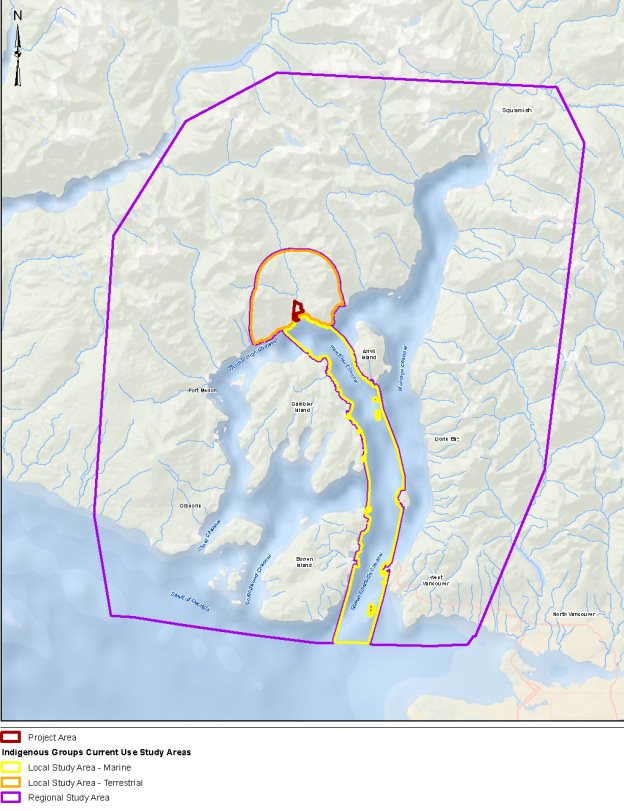
Source: BURNCO Project Environmental Impact Statement, Golder Associates Ltd.
The proponent considered material provided by potentially affected Indigenous groups, including occupational and traditional use studies prepared by Squamish Nation and Tsleil-Waututh Nation, and publicly available information sources. The proponent's assessment of effects to the current use of lands and resources for traditional purposes was focused on effects to Squamish Nation, Tsleil-Waututh Nation and Musqueam Indian Band. The analysis evaluated biophysical components such as water resources, fish and fish habitat, and terrestrial wildlife and their habitat, and vegetation and consulted with Indigenous groups on the potential effects to their current use practices from changes to these components.
Effects to Fishing
The proponent reported that Squamish Nation primarily fish for salmon, steelhead, Dolly Varden trout and other species of trout in the marine Local Study Area. Squamish Nation also harvests herring, eulachon, smelt, cod, flounder, halibut, lingcod, rockfish, sole, and shellfish in the Regional Study Area. The proponent also indicated that Tsleil-Waututh Nation harvest similar marine and freshwater species.
The proponent stated that the removal of Upper Watercourse 2 would result in a loss of fish habitat, which could decrease the availability of freshwater resources in the Local Study Area. The proponent proposed to construct new fish habitat as an upstream extension to Lower Watercourse 2 to offset the loss from the removal of Upper Watercourse 2 and ensure that the availability of salmon and trout is not affected. Noise from the marine barge-loading facility and the barges could deter marine fish from using areas close to the Project and along the barge route. The proponent predicted that there would be small residual effects to these species, but that there would be no change in the availability marine fish in Howe Sound for current use purposes.
The proponent expects changes in the ability for Squamish Nation to access marine and freshwater fish due to the construction of infrastructure and barge activity along the foreshore of the McNab estuary. There may also be access limitations on an intermittent basis related to barge traffic in the marine environment for Indigenous groups. The proponent committed to developing an Access and Communication Protocol with Squamish Nation, which would enable the two parties to coordinate and mitigate the loss of access to freshwater resources throughout the life of the Project. The proponent also indicated that the Marine Transport Management Plan would include provisions that promote communications and safe access to marine resources for other Indigenous groups.
The proponent did not predict changes to the quality of the fish being gathered in that it does not expect fish to become contaminated as a result of the Project (Section 4.6). It did however anticipate that the quality of the fishing experience may be affected by noise, changes to air quality, and visual changes. The sensory disturbances and dust generated by crushing, washing and moving gravel could affect an individual's willingness and ability to perform traditional activities in and around the Project area. The proponent intends to muffle sound, limit dust, and not operate at night, which are all measures that would also mitigate effects to the quality of the fishing experience. The proponent did not predict any changes to the quality of the species harvested by Indigenous groups.
Residual effects to the quality of the fishing experience for Squamish Nation fishing were predicted; no measurable residual effects were predicted for other groups.
Effects to Hunting
The proponent identified a variety of species that Squamish Nation currently hunt in the Regional Study Area including Roosevelt elk, deer, black bear, and several bird species. Tsleil-Waututh Nation also reported to the proponent that they hunt waterfowl and grouse in Howe Sound.
Project-related effects to mammals and birds would reduce their availability for hunting in McNab Valley. Noise from the Project site and along the barge route noise would disturb species and cause them to move to other, less disturbed habitat. The displacement would require Indigenous groups to seek out other areas in the region to hunt, or dissuade them from continuing the current use. The vegetation cleared for the pit lake and infrastructure would result in habitat loss including overwintering habitat used by Roosevelt elk (Section 4.4). The proponent proposed to develop a Habitat Compensation Plan for Roosevelt elk that would be approved by Squamish Nation. It also proposed mitigation to minimize noise levels (Section 4.5) and revegetate areas at the end of the Project. Not all effects to the availability of species that support hunting can be mitigated as the Project will still cause some noise, and the area that becomes the pit lake cannot be revegetated.
The proponent stated there would be a reduction in access for Indigenous peoples to hunt because the Project site would be fenced, and the marine foreshore would have security measures that prevent access to unauthorized users. These restrictions would make traditional use sites located up the McNab Valley more difficult to access, thereby reducing the ability for Indigenous peoples to hunt. The proponent proposed an Access and Communication Protocol where it would coordinate with Indigenous peoples who wish to use the Project area or pass through it. The proponent expects that the Access and Communication Protocol would mitigate all access effects to Indigenous peoples except for the loss of access to the project footprint.
Squamish Nation provided a letter to the Agency indicating that the protocol, when formalized, will contain sufficient provisions to mitigate impacts on their ability to access hunting resources. In addition, Squamish Nation would be involved in the development, implementation and approval of other management and monitoring plans.
Similar to the quality of fish, the proponent also did not predict changes to the quality of wildlife such as elk being gathered in that it does not expect these species to become contaminated as a result of the Project (Section 4.6). The proponent stated that Project may affect the quality of experience of hunting by Indigenous peoples in a similar manner as it would to fishing, and proposed to apply the same suite of mitigation measures. It also did not predict any changes to the quality of the species hunted by Indigenous groups. The proponent predicted residual effects to the availability of elk, and the quality of the hunting experience for Squamish Nation hunting, but did not predict any measurable residual effects for other groups.
Effects to Gathering
Based on available information, the proponent identified several tree and plant species that are used for medicinal, food and technology purposes in the Regional Study Area, although only limited use was noted in the Local Study Area. The vegetation gathered by Indigenous peoples at the Project site is found throughout the terrestrial and marine Regional Study Areas and includes berries, mushrooms, ferns, edible roots, grasses and seaweeds.
The proponent stated that clearing for the mine and the processing facility would reduce the availability of vegetation at the Project site, and that the Project may affect access to vegetation and the experience of gathering in a similar manner as it would to hunting. It did not predict any changes to the quality of the plant species gathered.
The proponent intends to mitigate these impacts by progressively revegetating the site during the life of the Project.
Residual effects to Squamish Nation gathering were predicted, but the proponent considered the effects to be too small to be measureable. No residual effects to gathering practices of other Indigenous groups were predicted.
Effects to Cultural Sites and Activities
Squamish Nation reported that the west side of Howe Sound is home to a number of culturally important sites for Squamish including Tsitsusm (Potlatch Creek) and K'ik'elxn (Port Mellon). The marine foreshore of the McNab Creek is known as Kw'ech'tenm, or "fish-cutting place". The site is an ancestral village of Squamish Nation where families would conduct ceremonies, hunters would harvest slate to make knives, and members would gather to collect resources and exchange knowledge. Kw'ech'tenm is presently used as a stop-over for youth programs and for teaching Squamish history and cultural practices within their nation.
The proponent noted that several land forms in Howe Sound near the barge route are considered sites sacred to Tsleil-Waututh Nation and are used in their traditional ceremonial practices.
The Project would cause changes to the valley bottom and the alluvial fan of McNab Creek which could have direct effects on Kw'ech'tenm. Approximately 60 hectares of land used for traditional purposes would be impacted, with approximately 30 hectares being permanently lost through the creation of the pit lake. The proponent stated there would be effects from reduced access to Squamish Nation cultural sites, and that these would be similar to effects of reduced access to hunting and gathering areas.
To mitigate effects to cultural sites and activities the proponent proposed that any future management plans for the site would be developed with and approved by Squamish Nation prior to being finalized. Further the proponent plans to enter into an agreement with Squamish Nation to honour Kw'ech'tenm as a cultural site. This would include developing chance-find protocols for any historical artifacts found on the site, and funding to erect a plaque or cultural displays as appropriate.
In addition, there may be effects on access to cultural sites along the barge route that Squamish Nation and Tsleil-Waututh Nation. The proponent intends to consult with both nations on measures to reduce effects to the quality of experience, as required.
The proponent stated that effects to the quality of experience to members of Squamish Nation and Tsleil-Waututh Nation would be similar to the effects to hunting.
No residual effects to Indigenous cultural sites and activities were predicted by the proponent.
Cumulative Environmental Effects
The proponent stated that they did not undertake a cumulative effects assessment on the effects to the current use of and resources for traditional purposes based on advice from Squamish Nation that such an assessment could not properly reflect cultural considerations of Squamish Nation.
Monitoring and Follow up
In addition to the follow-up measures proposed by the proponent in relation to the biophysical valued components, it committed to working with Indigenous groups on monitoring and follow-up programs for current use of lands and resources. The proponent committed to support Squamish Nation's Marine Use Planning process and work with Squamish Nation to develop and implement supplemental studies, mitigation, and monitoring programs. The proponent also committed to providing Squamish Nation and Tsleil-Waututh Nation with opportunities to review and comment on the Access Management Plan for Indigenous groups and will continue to consult with them on measures to reduce visual effects from the Project on quality of experience. The proponent would seek approval from Squamish Nation monitoring and follow-up programs Squamish Nation.
4.7.2 Views Expressed to the Agency
Comments received from Indigenous groups
A summary of comments provided by Indigenous groups during the environmental assessment is provided in Appendix D. Comments related to specific valued components are included in other sections of this Report.
Squamish Nation confirmed that the Local Study Area covers an area of preferred resource use and that Kw'ech'tenm, the Project site, has historic and cultural significance. It expressed concern about the effects to Roosevelt elk and the continued ability to hunt it. As part of Squamish Nation's Wildlife Focus Area for Elk in West Howe Sound the Nation intends to "expand the provincial elk reintroductions within Squamish territory in order to restore naturally occurring populations, and, provided conservation needs have been met, to provide future opportunities for Squamish Nation hunting for social and ceremonial purposes." Squamish Nation advised the proponent to not cut down forest habitat adjacent to the Project area because this would displace elk to new areas. There may be effects on traditional use because Squamish Nation would need to re-learn the best locations to hunt elk as the animals move to other areas.
Squamish Nation community members indicated that increased industry could lead to a mistrust of the quality of traditional foods, resulting in decreased harvesting, the loss of transmission of knowledge to the next generation and a decrease quality of experience. Squamish Nation also expressed concern about ensuring their involvement in developing access management and monitoring plans for the life of the Project, and not just during the environmental assessment.
Tsleil-Waututh Nation expressed concern about effects to fish and fish habitat and the resulting effects on their traditional practices in the region. It provided the Agency with detailed comments regarding the potential impacts to wildlife and marine resources, as well as concerns regarding the proponent's research methodologies. Tsleil-Waututh Nation was also concerned about the overall effects of the Project on the transmission of culture and cultural knowledge. Tsleil-Waututh Nation noted that its exclusion from the Project area over time means that a variety of cultural activities would not be practiced, and it would become more difficult to pass down knowledge specific to the location. Tsleil-Waututh Nation worked with the proponent on a Traditional Use Study to better understand the effects of the Project on the community's current use of the Project area. The proponent committed to ongoing consultation with Tsleil-Waututh Nation and proposed mitigation measures to address effects on Tsleil-Waututh Nation's quality of experience in the study area. Tsleil-Waututh also expressed that, until management plans have been developed and the success of these management plans have been monitored, the extent of residual effects to current use is uncertain.
Musqueam Indian Band stated that the community uses the Project site and Bowen and Passage Islands to hunt deer. It also stated that the community harvests marine species such as herring and prawn in Howe Sound. Musqueam Indian Band expressed concern about their ability to hunt in the Project area due to the environmental effects of Project activities and their ability to harvest marine traditional use resources from Howe Sound due to increased marine shipping. The proponent responded that its proposed mitigation for fishing and hunting effects would be effective to mitigate effects to Musqueam Indian Band hunting deer at the Project site and harvesting in Howe Sound. It also responded that it did not predict any Project interactions with terrestrial values on Bowen and Passage Islands.
4.7.3 Agency analysis and conclusions
The Agency conducted its own analysis on the effects of Project-related changes to the environment on the current use of land and resources for traditional purposes by Indigenous peoples using information provided by the proponent and Indigenous groups. As part of assessing effects related to availability, access, quality of the resource, and the quality of the experience of Indigenous peoples the Agency also considered changes to the overall success of the ability of Indigenous groups to practice their current use. Based on the information available, measurable residual effects to gathering would be unlikely to occur, while residual effects to fishing, hunting and cultural activities would be likely. None of the residual effects were determined to be significant.
Fishing
The Project would have residual effects on Indigenous peoples' ability to fish in the freshwater and marine environments because it may result in a loss of abundance of harvested fish species in the McNab Area and adversely affect the quality of the fishing experience. The Agency does not expect there to be effects to the access to fishing site or quality of fish harvested.
McNab Creek is not expected to be impacted, but the fish rearing and spawning habitat in Watercourse 2 would be impacted, with its upper portion removed entirely. Offsetting habitat described in Section 4.2, is expected to compensate for any effects on the availability of fish. Residual effects to the ability for Indigenous peoples to access Watercourses 1-5, and the quality of the fishing experience would remain.
After the proponent's mitigation, the magnitude of the effects to fishing is considered low. The extent of the effects to freshwater fishing would be local, the frequency would be continuous, the effects would be reversible and the duration would be medium-term as the effects would occur in all Project phases. Since Indigenous peoples fish in streams throughout the region their ability to successfully fish in the freshwater environment would not be measurably affected and the Project's residual effects on Indigenous freshwater fishing would not be significant.
In the marine environment the residual effects on Indigenous fishing would be similar to those in the freshwater environment. In addition effects from barge loading and shipping may decrease fish availability along the foreshore of the McNab estuary and the barge route, and Project activity may deter Indigenous peoples from fishing in those areas.
The magnitude of residual effects on Indigenous peoples' ability to fish in the marine environment is considered low because of the small amount of habitat that would be disturbed, and because the activity could shift to several other nearby areas. The frequency of the effect would be multiple regular events, and occur for the life of the Project, but is expected to be reversible after decommissioning. The extent of residual effects in the marine environment would be the Regional Study Area. Since Indigenous people's fish throughout Howe Sound, and the Project would consist of one barge transiting every two days, their ability to continue to fish in the marine environment would not be measurably affected and the Project's residual effects on Indigenous people's ability to fish in the marine environment would not be significant.
Hunting
The Project would have residual effects on Squamish Nation's hunting of elk because there would be fewer elk at the Project site, their members' ability to access the area may be reduced, and the quality of the hunting experience would decrease. The effects to hunting would be due to elk being displaced as a result of the loss of habitat from the pit lake and vegetation removal, and from sensory disturbance.
With the proponent's commitment to provide Squamish Nation access to the Local Study Area and consult with them on environmental management and monitoring plans, the effects to hunting would be low magnitude, and concentrated around the Local Study Area. The practice of hunting elk was restored as the animals were reintroduced to the area in 2001 and 2002 [8], and the practice is moderately vulnerable to change. The residual effects from sensory disturbances to elk would be for the life of the Project and be reversible; however, the loss of overwintering habitat from the excavation of the pit lake would be permanent and irreversible. Squamish Nation would still have the ability to hunt elk in McNab Valley since the animals would overwinter in new habitat, and elk hunting is expected to be able to be continued during all Project phases. The residual effect on Squamish Nation's current use of hunting elk would be not significant.
The Project would have similar residual effects on Squamish Nation's practice of hunting other wildlife in the area such as deer, grouse, and migratory birds as it would to the current use of hunting elk. This would be due to the loss of habitat and the displacement of animals from sensory disturbances. Given the prevalence of these species throughout the region, and the application of mitigation such as maintaining Squamish Nation's access to the Project area, the Agency is of the view that the residual effects to hunting would be not significant.
Cultural Activities
The Agency acknowledges that Squamish Nation considers the Project area to be an important and preferred area for the practice of cultural activities. Tsleil-Waututh Nation has indicated that the Project area is used by and is of value to its members because of the availability of traditional resources and its historical, intergenerational connections to the landscape. Squamish Nation and Tsleil-Waututh Nation provided this information through their respective, written submissions, and in meetings with the proponent and Agency officials.
The Agency concludes there would be a residual effect to Squamish Nation on the current use of lands and resources for cultural and ceremonial activities but these effects would not be significant if the agreed upon mitigation measures are properly implemented by the proponent. Residual effects on the current use of lands and resources for cultural and ceremonial activities for other Indigenous groups are not anticipated.
Cumulative Effects
The Agency is of the view that the residual effects to fishing, hunting and cultural activities as a result of the Project are all likely to act cumulatively with the effects of existing projects in the region.
Effects to fishing in both the freshwater and marine environments are likely to interact cumulatively with the effects of human activities throughout Howe Sound. In the freshwater environment the Howe Sound region has experienced increased fishing on multiple watercourses and the Project remains one of the few areas not accessible by overland vehicles. Further with increases in industrial activities, such as the Woodfibre LNG Project, and increases in pleasure craft users in the region, there are fewer undisturbed foreshore habitats in Howe Sound. According to advice from Fisheries and Oceans Canada, the absence of industrial development has made McNab Creek one of the few remaining alluvial fans in the region that is not disturbed by human activity or infrastructure.
The Agency expects that cumulative residual effects from the Project and from other human activities in the region would have adverse effects to traditional hunting practices of Indigenous peoples. Cumulative sensory disturbances from the Project, the Box Canyon Hydroelectric Project, the Woodfibre LNG Project, and other projects could push ungulates to less accessible areas, which in turn could reduce the likelihood of success for Indigenous hunters. If the Project and other developments improve access for non-Indigenous hunters, hunting pressure could increase in previously inaccessible areas like McNab Valley. The industrialization of Howe Sound from the development of these projects may reduce the quality of the hunting experience and the likelihood that Indigenous hunters would use the area.
Residual effects would only be likely to occur to cultural activities practiced by the Squamish Nation. As a result, cumulative effects to Squamish Nation cultural activities are likely as other culturally important locations in their traditional territory have been affected by other industrial activities in the region. Squamish Nation has indicated that, after mitigation, residual effects of the Project to their culture would remain and that these residual effects would be "acceptable (non-significant)". Consequently the Agency has determined that cumulative effects to cultural activities would not be significant.
Overall Agency Conclusions
Given the above assessment and taking into account the implementation of applicable mitigation measures, the Agency concludes that the Project is not likely to cause significant adverse environmental effects to the current use of land and resources for traditional purposes by Aboriginal peoples.
5 Other Effects Considered
5.1 Effects of Accidents and Malfunctions
This section provides a summary of potential effects of the Project from accidents and malfunctions during construction and operation, and the mitigation measures proposed to reduce their likelihood and address the associated effects should they occur. The Agency conducted an analysis and concluded that the Project is unlikely to cause significant adverse environmental effects due to accidents and malfunctions.
5.1.1 Proponent's Assessment
The proponent assessed the following accidents and malfunctions: pit slope failure; discharge of sediment into watercourses, including as a result of the loss of the containment of the aggregate pit; hazardous material spills; and vessel and barge accidents causing an aggregate spill. These scenarios are discussed below.
Slope failure
The proponent stated that failure of gravel slopes such as those surrounding the pit lake and in the marine foreshore could occur. Failure could impact the safety of mine personnel, result in the loss of marine habitat and alter the drainage characteristics on site. Slope failure could occur as a result of earthquake-related ground movements or landslides (Section 5.2), above-ground works such as bulldozers and handling construction materials, and below-ground works such as facility modifications, gravel extraction and slope re-contouring. Similarly, project activities in the marine foreshore could cause shoreline erosion and debris deposition. Slope failures near or adjacent to waterbodies could result in slumping that diverts water or causes it to pool in certain areas, thereby changing the drainage characteristics on the site.
The proponent proposed to implement the following mitigation measures to prevent the likelihood of slope failure:
- conduct detailed, site-specific geotechnical subsurface investigations;
- design structures to abide by all provincial and federal standards, codes and regulations;
- monitor slope stability during operation and update or modify designs if required to achieve Project performance requirements;
- conduct assessments to identify connectivity of site earth works to watercourses;
- conduct assessments of terrain stability conditions along watercourse banks and connectivity to planned site activities;
- conduct appropriate debris flow/flood hazard and effects assessments, including hydrotechnical assessments;
- conduct ongoing monitoring and investigations of terrain stability and geotechnical conditions to achieve performance requirements and mitigation; and
- prepare engineered designs and plans, including diversion and catchment structures, by qualified and experienced professionals.
With the implementation the above mitigation measures the proponent concluded that slope failure was unlikely and that residual effects would be negligible or not significant.
Pit Containment Failure
The proponent stated that failure of the containment berm could be caused by a breach or by a failure of the overflow structure. This would result in an accidental discharge of sediment into fish bearing watercourses. Such events could result in:
- reduction in downstream groundwater flow;
- changes to surface water and groundwater quality from sediment discharge;
- changes in fish habitat quality;
- potential mortality to fish from suffocation, smothering or crushing due to release of sediment; and
- indirect habitat loss or potential changes to habitat quality for terrestrial species at risk.
The environmental effects of sediment discharges depend on type and amount of material spilled. A worst-case scenario of the containment berm failing could result in the exceedance of federal water quality guidelines in fish bearing watercourses, destruction of fish habitat, and killing of benthic invertebrates and fish. Depending on the location of the containment berm failure, the uncontrolled release of water could result in water levels in the pit lake dropping as much as four metres in elevation, and reducing groundwater flows by up to 35% in Watercourses 1-5, which are downstream of the pit lake.
The proponent proposed to implement the following mitigation measures to prevent the discharge of sediment into watercourses (in addition to those already described in Section 4.2):
- adhere to B.C.'s Dam Safety Regulation, the Reclamation and Effective Closure Plan, and the Spill Prevention and Emergency Response Plan;
- implement an Erosion and Sediment Control Plan, a Fisheries Habitat Protection and Mitigation Plan, and an environmental effects monitoring program;
- re-vegetate disturbed areas adjacent to watercourses;
- implement progressive reclamation;
- implement a groundwater monitoring program including monitoring wells for flow and quality, both upstream and downstream of the open pit, as well as, monitoring of water levels in the pit lake;
- implement adaptive management techniques by comparing monitoring data with assessment predictions; and
- construct an overflow structure at an elevation of 5.2 metres to maintain baseline groundwater levels.
With the implementation of best management practices and the above mitigation measures, the proponent concluded that pit containment failure was unlikely and that residual effects would be negligible or not significant.
Hazardous Material Spills
The proponent stated that hazardous materials could enter the terrestrial or marine environment through accidental spills from mechanical equipment, equipment malfunction, spills during refueling, transportation of fuels and solid wastes, pit containment breach, concrete casting, storm water runoff and sewage release. The most likely spill scenario would involve the release of small quantities of hazardous materials from equipment failure or human error.
Hazardous material spills onto land or into aquatic ecosystems could result in the following environmental effects:
- degradation of water or soil quality;
- mortality of species at risk, marine benthic communities, migratory birds, fish, and marine mammals;
- reduced availability of prey; and
- changes to Indigenous heritage resources.
The proponent proposed to implement the following mitigation measures to prevent hazardous material spills:
- implement a Spill Prevention and Emergency Response Plan, a Materials Storage, Handling and Waste Management Plan, a Fisheries Habitat Protection and Mitigation Plan, a Pile Construction Management Plan, and an Erosion and Sediment Control Plan;
- restrict refueling to areas outside of environmental buffers, waterways and the marine foreshore;
- inspect, clean, and maintain vessels and machinery regularly;
- contain concrete pouring activities near waterbodies, monitor pH levels during pouring and keep a carbon dioxide bubbler on site to mitigate any accidental releases;
- store hazardous materials and wastes in designated areas only, for appropriate off-site disposal;
keep spill kits on site and train personnel to use spill response equipment; and
- prevent the discharge of equipment wash water to terrestrial habitat or to watercourses.
The proponent will also be required to comply with the regulations of the Canada Shipping Act, the Transportation of Dangerous Goods Act, and B.C.'s Hazardous Waste Regulations. In the case of a spill of magnitude that requires reporting, the nearest Canadian Coast Guard Station or Emergency Coordination Centre would be contacted.
The proponent predicted that accidental hazardous material spills on land and in the marine environment would have a low likelihood of occurrence. After implementing mitigation measures, it concluded that the residual adverse environmental effects would not be significant.
Vessel and Barge Accidents
The proponent stated that accidents could occur during barge loading operations or during barge transit if a tug boat or another vessel collided with the barge or with the marine barge-loading facility. These accidents could result in aggregate spills or fuel release from vessels.
In a worst-case scenario the entire payload of a full barge of aggregate (5,333 cubic metres) could spill into the marine environment. The aggregate plume would enter the water column, and rapidly settle on the sea floor, likely covering an area up to 150 metres by 300 metres. Potential environmental effects of aggregate spills include:
- loss, alteration or degradation of marine habitat ;
- localized mortality of benthic organisms or larval/juvenile marine fish due to smothering or sedimentation; and
- destruction or degradation of glass sponge reefs, if the spill occurs where these are present.
Accidents such as vessel sinking, vessel running aground, collisions with other vessels or shoreline structures, could result in the release of large quantities of fuel into the surrounding environment. Environmental effects would likely be more severe if a fuel spill occurred in shallow waters near shore or in areas with slow water circulation as the fuel would remain in high concentrations for a greater period of time. The worst-case scenario would be the release of fuel from a full tug boat fuel tank, 81 cubic metres, into the marine environment. This would result in adverse effects to marine water quality and potentially toxic effects to aquatic species, fish, marine mammals and marine birds.
Mitigation measures, in addition to those mentioned in Section 4.3, to prevent aggregate or fuel spills as a result of vessel and barge accidents include:
- using of collision-prevention devices (lights, sound signals, radar reflectors), navigation safety aids, radio equipment and communications, pollution prevention measures and alarms, emergency systems, fire safety and lifesaving equipment, personnel training and competence, and ship structural conditions, on all marine vessels and barges.
Given the non-toxic nature of aggregate, the limited spatial extent of a potential spill and the nature of the receiving environment, along with the low likelihood of occurrence, the proponent concluded that the potential effects of a major aggregate spill would be unlikely and any adverse effects would be negligible or not significant.
5.1.2 Views Expressed
Slope Failure
Fisheries and Oceans Canada (DFO) requested that the proponent describe any effects or risk associated with increased groundwater flow and associated hydrostatic pressure on the stability of the sediments and slopes in the marine estuary, the potential for movement and any associated effects to fish and fish habitat. The proponent responded indicating that the hydrogeological model estimated groundwater flow and hydrostatic pressure and that changes to the stability of the delta in the marine foreshore were not expected. The proponent proposed to supplement the model by conducting marine foreshore monitoring using aerial drones to map erosion patterns (Sections 4.3 and 8).
Pit Containment Failure
The public noted that the dyke and berm would need to be maintained in perpetuity to ensure that failure does not occur, and questioned whether the proponent would do so, and whether it would be held liable for any future damages. The proponent responded that, as the property owner and the holder of a permit under B.C.'s Mines Act, it would be required for all post-operation maintenance.
Hazardous Materials Spills
Environment and Climate Change Canada (ECCC), Tsleil-Waututh Nation, Cowichan Tribes and the public expressed concerns about spills, and requested additional details regarding mitigation and follow up plans in the event of a spill of deleterious substances and its effects on fish and wildlife, including species at risk. ECCC and the public also requested that the proponent consider worst-case scenario spills regarding the rupture of the vessel's fuel tank, and spills of all other types and quantities of oils and gear lubricants required to operate Project vessels. The proponent noted that it was committed to responding to spills based on current best management practices, and that it would follow the mitigation measures outlined in its Spill Prevention and Emergency Response Plan. This plan would apply to spills of all fuel types and worst-case scenarios. A Wildlife Protection Plan would also detail mitigation measures and specific response protocols in the event that a spill had the potential to affect fish, wildlife, and species at risk.
Health Canada requested that the proponent provide more information regarding the potential adverse health effects associated with accidental land-based spills and the ingestion of contaminated surface water, including any specific mitigation measures that are relevant from a human health perspective. The proponent responded that it conducted conservative exposure scenarios as part of the human health risk assessment and noted that it did not identify any risks that required additional mitigation.
Vessel and Barge Accidents
Musqueam Indian Band and members of the public expressed concern regarding potential adverse environmental effects from barge accidents, including concerns about marine transportation safety and sediment spills impacts on glass sponge reefs. Musqueam Indian Band also requested specific information on the quantity and type of waste and fuel that would be transported by barge, and potential effects to terrestrial values on Bowen Island and Passage Island, and mitigation measures including emergency measures to address potential spills.
The proponent responded that sediment and aggregate spills from barges were unlikely and that it would follow all requirements of the Canada Shipping Act, the Transportation of Dangerous Goods Act, and the Fisheries Act. In addition to aggregate and fuel, barges would transport industrial and domestic waste, as well as sewage effluent. The barge and tug boat operators would conform to ISO 14001:2004 standards, and would implement best management practices related to hazardous materials management, waste management and recycling, spill prevention and response, and site management and housekeeping. The proponent did not predict any potential interactions between the Project and terrestrial values on Bowen and Passage Islands, and therefore no adverse effects were predicted to Musqueam current use from changes to these valued components at these locations.
5.1.3 Agency Conclusion
The Agency is satisfied that the proponent identified and assessed the potential accidents and malfunctions associated with the Project. The proponent proposed measures to avoid or prevent potential accidents and malfunctions, and contingency and response plans that would be implemented should an accident or malfunction occur.
The Agency concludes that although accidents and malfunctions such as the failure of the pit lake containment berm and flood protection dyke could result in significant adverse environmental effects, these accidents and malfunctions are unlikely to occur.
The Agency concludes that the Project is not likely to result in significant adverse environmental effects as a result of accidents and malfunctions, taking into account the likelihood of occurrence, the Project design, implementation of mitigation measures, and the response actions to which the proponent has committed.
5.2 Effects of the Environment on the Project
Environmental factors that could potentially affect the Project and lead to adverse environmental effects include extreme weather events, seismic activity, tsunamis, terrain stability events, wildfires, and climate change. These factors may damage land-based and marine infrastructure as well as affect operational performance, and could increase the probability of accidents and malfunctions. Environmental effects could include the loss or contamination of habitat, reduced water and air quality, and effects on fish, aquatic species and wildlife. The Agency conducted an analysis and concluded that the effects of the environment on the Project are unlikely to cause significant adverse environmental effects.
5.2.1 Proponent's Assessment
Extreme Weather Events and Avulsion Risk
The Project would be designed to withstand extreme precipitation events. The proponent intends to build a 750 metre long, four metre wide flood protection dyke along the north and east perimeter of the pit lake, approximately 35 metres from McNab Creek. This would ensure that floods induced by heavy rains do not travel overland into the Project area.
River avulsion is a phenomenon where a river or creek suddenly changes course to form a new channel or channels. Fisheries and Oceans Canada (DFO) indicated early in the assessment that the Project may cause the avulsion of McNab Creek. This potential was identified because the removal of the gravel, which currently acts as a barrier forcing the creek to flow to the east, would create a space through which fast moving water would flow. As such, during an extreme rain event the high volume of water could cause McNab Creek to breach the pit lake, and flow downstream into a new and unpredictable trajectory. River avulsion would result in the permanent destruction of lower McNab Creek, mortality of fish and benthic invertebrates present during the event, and permanently alter Watercourses 1-5 and the marine foreshore area.
In order to prevent the avulsion of McNab Creek the proponent would build the flood protection dyke to withstand a one in 500-year flooding event (Figure 10). The proponent would also impose a minimum setback for construction of 75 metres from McNab Creek to further reduce avulsion risk. Additional mitigation for extreme precipitation would include provisions for side drainage and sedimentation, and erosion control.
Figure 10: Flood Protection Dyke and Inundation Area
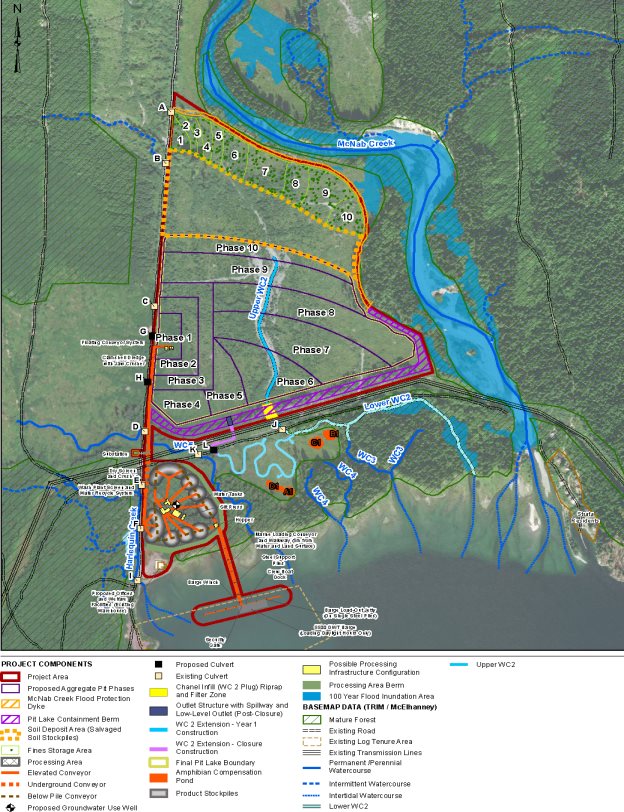
Source: BURNCO Project Environmental Impact Statement, Golder Associates Ltd.
Drought could result in extreme surface water low flows in the Project area, and reduced groundwater levels. This could impact mine operations, as groundwater is required as make-up wash water for processing activities. The proponent has implemented design elements, including a high-efficiency wash plant that will use 95% recycled wash water, to reduce its groundwater withdrawal needs. Should groundwater levels be too low, the proponent would implement adaptive management measures, including potentially reducing the processing of washed products, such that effects to fish habitat would not occur.
Seismic Activity and Tsunamis
The proponent evaluated the effects of seismic events on Project components. The proponent stated that earthquakes could cause slope failure of the pit lake, containment berm, flood protection dyke, and the marine foreshore. Landslides could occur which may change slope morphology and drainage characteristics in the Project area and along the McNab Creek corridor. Debris flows down the creek and the steep slopes of McNab Valley may also occur.
In a worst-case scenario, a major earthquake could induce the liquefaction of the natural fluvial and fan-delta deposits that comprise the Project area, as well as initiate a submarine landslide event. This would have severe effects on both the terrestrial and marine environments.
The Project is located within a zone of moderate to high earthquake risk. As such, the proponent would build all structures to withstand earthquakes with 1:2745 to 1:5000 year return periods (approximately 7.0 on the Richter scale).
A tsunami event has the potential to result in shoreline erosion and instability, damage and distress to Project facilities, and risk to site personnel. There is no evidence of past tsunami activity in Howe Sound, however, tsunamis off the west coast of Vancouver Island have been recorded approximately once every 500 years. The proponent predicted that if a 15 metre tsunami wave were generated off the west coast of Vancouver Island, it would be reduced to two metres by the time it arrived at the entrance of Howe Sound in Lions Bay. A wave of this height in the Project area could cause damage to marine terminal structures, especially if it coincided with higher high water or large tide events. Other Project facilities are not expected to be affected, as they would be located 50 metres inland at an elevation of three to five metres above sea level.
The proponent would develop an Emergency Response Plan to assist in responding to earthquakes or other land-based movement events. The Emergency Response Plan would conform to the Canadian Standards Association Emergency Preparedness and Response: A National Standard of Canada, would meet the requirements of B.C.'s Mines Act and the Health, Safety and Reclamation Code, and would meet the regulatory requirements specified by the B.C.'s Ministry of Energy, Mines and Petroleum Resources.
The proponent concluded that the above mitigation measures would minimize and manage potential adverse environmental effects. The likelihood of occurrence of an earthquake greater in magnitude than the design criteria is low. As such, the proponent predicted that residual effects would be not significant.
Terrain Stability
The proponent conducted a terrain stability assessment to evaluate the potential risk of debris flows, slides and snow avalanches on the Project. Terrain stability conditions do not appear to directly affect the Project area or facility locations. Debris flows in the Regional Study Area could reach McNab Creek and thus affect sections of the Creek adjacent to the Project area. Potential environmental effects include debris floods, avulsion, erosion, and the initiation of debris slides, flows and slumps of unstable channel side banks. The potential damage to the Project was predicted to be not severe.
Wildfire
Wildfires have the potential to harm human life and destroy Project facilities. Historical records indicate that wildfires do occur in the Regional Study Area, although the majority have been very small (less than 0.5 hectares in size). To minimize fire risk, the proponent would appropriately manage fuels and flammable materials to avoid spontaneous combustion; manage activities that may increase the risk of fire; develop a fire response plan; maintain and inspect fire suppression equipment; review fire hazard ratings; and communicate with provincial authorities to identify any wildfire threats.
Climate Change
Climate models suggest that over a 30-year period B.C.'s south coast will experience an increase in temperature of 1oC to 3oC and an increase in precipitation of two to four percent annually. Models indicate that summers will likely become drier, with an increase in heatwave frequency, intensity and duration. Winter precipitation is predicted to increase, with a greater frequency of heavy rainfall events and storms. Project design will incorporate climate factor considerations including extreme weather events as discussed above.
Increases in global temperatures could also contribute to an estimated sea level rise of 0.06 metres to 1.18 metres by 2100. The degree of change within the life of the Project is within the Project's design specifications and all marine and land based infrastructure would be removed upon closure, predicted to begin in 2035. Therefore, considerable climate-infrastructure effects are not predicted to occur.
5.2.2 Views Expressed
Extreme Weather Events and Avulsion Risk
During the review of the EIS, Natural Resources Canada (NRCan), provincial authorities and the public reaffirmed the concern about the risk of avulsion raised by DFO earlier in the assessment. NRCan noted that the original design of the flood protection dyke did not fully protect the pit lake from all areas along McNab Creek where there was an avulsion risk. Further, the Agency and provincial authorities noted that the dyke was only designed to withstand a one in 100 year flood. The proponent responded by redesigning the dyke to protect the entire north and east perimeter of the pit lake, and be capable of withstanding a one in 500 year flood.
Seismic Activity and Tsunamis
NRCan, Tsleil-Waututh Nation and members of the public expressed concerns about whether all effects from seismic events on the Project had been addressed. NRCan requested that the proponent confirm the magnitude and length of time of a seismic event that would be expected to induce liquefaction, a phenomenon where the ground exhibits the properties of a liquid. The proponent responded that significant liquefaction would likely only be associated with a one in 2475 year event, with an anticipated level of shaking equivalent to a magnitude 7 earthquake on the Richter scale, and a period of shaking of 20 to 30 seconds.
Tsleil-Waututh Nation indicated that earthquakes occur on a regular basis in the region and that, depending on the magnitude of the earthquake, there may be cumulative effects from smaller earthquakes on terrain stability. The proponent responded that it would evaluate the stability of the containment berm and the flood protection dyke throughout the life of the Project and that it would apply adaptive management to ensure the integrity of these structures following any small seismic events.
Terrain Stability
Tsleil-Waututh Nation and members of the public noted disagreement with the proponent's assessment on terrain stability, and requested additional assessment on the potential for landslides, debris floods/debris flows. Members of the public noted that extreme rain and wind events in the McNab Creek watershed frequently cause landslides and debris flooding, and that a landslide had occurred on the banks of McNab Creek in 1997. The proponent indicated that there was a lack of evidence for significant, historical debris floods or flows both upstream and downstream of Project site, on McNab Creek. It also indicated that with the application of the proposed mitigation measures such as the flood protection dyke, the risk of effects to the Project area would be low.
5.2.3 Agency Conclusions
The Agency is satisfied that the proponent has adequately identified potential effects of the environment on the Project and that the final design of the project would account for these effects. The Agency is confident that, with the flood protection dyke being built to withstand a 1 in 500 year flood event in all areas of the Project where McNab Creek may breach the pit lake, the structure would be sufficient to withstand debris floods or flows similar to those experienced in 1997. As such the Agency has determined that the likelihood of avulsion is low and the dyke would be sufficient to mitigate potential adverse environmental effects.
5.3 Effects on the Capacity of Renewable Resources
Under section 16(2)(d) of the former Act, a comprehensive study must consider "the capacity of renewable resources that are likely to be significantly affected by the project to meet the needs of the present and those of the future".
Renewable resources that may be affected by the Project include water resources, freshwater fish and fish habitat, and terrestrial resources. Significant adverse residual effects on these resources could, for example, result in a reduced capacity to support sustainable fishing, harvesting, hunting, and other renewable resource-based activities. The impact of the Project on these renewable resources was assessed in previous sections of this Report. In each case, based on the implementation of measures proposed to mitigate and compensate the effects, the Agency concluded that the residual effects on these renewable resources were not likely to be significant.
The Agency therefore concludes that the Project is not likely to adversely impact the capacity of renewable resources to meet the needs of the present and those of the future when the implementation of mitigation measures is taken into account.
6 Impacts on Potential or Established Aboriginal Rights including title
6.1 Consultation Activities
The federal government has a duty to consult and, where appropriate, to accommodate, when it has knowledge that its proposed conduct might adversely impact potential or established Aboriginal or Treaty rights. Meaningful consultation is undertaken as an important part of good governance, policy development, and informed decision-making.
As an initial step in fulfilling Canada's duty to consult as part of the environmental assessment, the Agency conducted a preliminary depth of consultation assessment for each potentially affected Indigenous group. The depth of consultation assessment is based on the nature and extent of potential or established Aboriginal rights and the potential adverse impacts of a project on those rights. The interaction between these two factors allowed the Agency to determine the appropriate depth of consultation for the Project for each potentially affected Indigenous group, and the consultation activities that are commensurate with that depth. This assessment was revised throughout the environmental assessment as new information was acquired.
The former Act also requires that federal environmental assessments consider the effect of any environmental change caused by the Project on the current use of lands and resources for traditional purposes by Aboriginal persons (Section 4.7).
The Agency coordinated the federal Crown's consultation activities with Indigenous groups and, together with other federal departments, integrated consultation into the environmental assessment process. Indigenous groups were provided with opportunities to learn about the Project, evaluate it, and communicate their concerns to the federal and provincial Crown. The Agency consulted through a variety of methods including phone calls, email, letters, site visits, and in-person meetings.
The Agency determined that ten Indigenous groups had rights that may be affected by the Project: Squamish Nation, Tsleil-Waututh Nation, Musqueam Indian Band, Hul'qumi'num Treaty Group (Stz'uminus First Nation, Cowichan Tribes, Halalt First Nation, Lake Cowichan First Nation, Lyackson First Nation, Penelakut Tribe) and Métis Nation British Columbia. Squamish Nation was consulted at a high depth; all other groups were consulted at a low depth.
The Agency notified each Indigenous group of key milestones in the environmental assessment process, including opportunities for participation; invited groups to comment on key environmental assessment documents and the environmental effects of the Project; and invited groups to submit information to the Agency on their potential or established Aboriginal rights, current use of lands and resources for traditional purposes, and how the Project could impact those rights, lands or resource use.
Consistent with being consulted at a high depth, the Agency engaged in additional consultation activities with Squamish Nation due to the possibility of more severe impacts on their potential Aboriginal rights. These activities included participation in technical working groups, invitations to site visits, and additional in-person meetings.
Although identified as a low depth group by the Agency, additional consultation activities not normally afforded to low depth groups were conducted with Tsleil-Waututh Nation because the provincial government chose to consult them at a moderate depth, and as such Tsleil-Waututh Nation was part of the provincial working group. Tsleil-Waututh Nation actively participated throughout the environmental assessment, provided comments on the scope of the assessment and the potential environmental effects, and attended technical meetings and site visits.
Musqueam Indian Band, also consulted at a low depth, actively participated in the latter stages of the EA, and attended in-person meetings and provided written comments about potential impacts to their asserted and proven rights.
The Agency's Participant Funding Program allocated funds to reimburse eligible expenses incurred by Indigenous groups during their participation in the environmental assessment. Squamish Nation, Tsleil-Waututh Nation, Musqueam Indian Band, Cowichan Tribes, Halalt First Nation, Penelakut Tribe and Métis Nation BC applied and received funding for participation in the environmental assessment process. In total the Agency allocated $78,925 to support participation by Indigenous groups in the environmental assessment.
Provincial Consultation Activities
The Agency and B.C.'s Environmental Assessment Office ( EAO) conducted joint consultation with Indigenous groups throughout the environmental assessment. This coordinated approach included aligning comment periods, holding joint technical working group meetings, and meeting together with Indigenous groups. An exception to this coordinated approach is that only the Agency consulted Métis Nation British Columbia.
Squamish Nation and Tsleil-Waututh Nation were a part of the provincial working group. The EAO consultation activities associated with the working group were often coordinated with the Agency, and included notifications at key environmental assessment milestones and participation in meetings to identify their interests that may be affected and measures to avoid, mitigate, address or otherwise accommodate impacts. Additionally, Squamish Nation and Tsleil-Waututh Nation had an opportunity to review and comment on key documents such as the EAO's draft Assessment Report and Table of Conditions during its development.
Proponent Engagement Activities
The Agency instructed the proponent to engage with Indigenous groups to collect information and provide an assessment of the effects of the Project on the current use of lands and resources for traditional purposes by Indigenous persons, and to document and assess impacts to any potential or established Aboriginal rights.
The proponent engaged Squamish Nation throughout the environmental assessment process and received input on its EIS and subsequent submissions to the Agency. Squamish Nation representatives attended working group meetings, and one-on-one meetings with the proponent to discuss the potential impacts to their asserted rights. Additionally, Squamish Nation undertook a confidential occupational use study funded by the proponent to identify rights that may be impacted and mitigation or accommodation measures to address the impacts.
The proponent engaged with Tsleil-Waututh Nation to discuss the potential impacts on the Nation's Aboriginal rights and measures to mitigate those effects. As part of their consultation activities the proponent funded a traditional use study for Tsleil-Waututh Nation to better understand their rights and uses in and around the Project area.
The proponent engaged with Musqueam Indian Band, Stz'uminus First Nation, Cowichan Tribes, Halalt First Nation, Lake Cowichan First Nation, Lyackson First Nation, Penelakut Tribe, and Métis Nation B.C. by providing each group with an opportunity to review information to the included in the Environmental Impact Statement. Each group was solicited for information on potential effects on their asserted rights and incorporated any comments received into their assessment.
6.2 Potential or Established Aboriginal Rights Including title
The following is a summary of the potential or established Aboriginal rights including title for each Indigenous group who may be adversely impacted by the Project, based on existing Crown knowledge, Agency and provincial consultation, as well as information received from groups and the proponent's submissions.
Squamish Nation
The Project area is located wholly within the traditional territory of Squamish Nation [9] which ranges from Point Grey in the south to the Cheakamus River in the north. Squamish Nation is comprised of descendants of the Coast Salish peoples who lived in the present day Greater Vancouver, Gibsons Landing and Squamish River watershed areas. Squamish people primarily reside in 9 communities in West Vancouver and North Vancouver, and near the town of Squamish. There are no currently occupied settlements on or near the Project area.
Squamish Nation asserts hunting, fishing, gathering and cultural rights, as well as title for Howe Sound, including the Project area. They indicated that the Project could potentially impact a broad range of Squamish rights and related interests at McNab Creek and in the Howe Sound area including freshwater and marine fisheries and habitat, wildlife and its habitat, vegetation and gathering practices, places of spiritual and cultural importance, archaeological sites, and economic and governance considerations.
Squamish Nation indicated to the Agency in late 2016 that they would like to focus efforts on direct engagement with the proponent to discuss potential impacts to their rights, rather than meet with provincial and federal representatives. The Agency's analysis is therefore based on information collected from Squamish Nation previous to 2016, focused Squamish comments on key documents subsequent to 2016 and from other sources such as the proponent. Where possible, the Agency sought feedback directly from Squamish Nation, including on this report.
Tsleil-Waututh Nation
Tsleil-Waututh Nation fishing and marine areas could potentially be impacted by barge traffic in Howe Sound. The Local Study Area for the terrestrial component of the Project falls outside of Tsleil-Waututh Nation's traditional territory; however the Project's Regional and Local Marine Study Areas contain terrestrial lands within the consultation area. Tsleil-Waututh Nation has consistently expressed concerns regarding marine and terrestrial impacts, and has identified Howe Sound as an area that contains landforms and areas of cultural importance.
Musqueam Indian Band
The Project area is not within the B.C. Treaty Commission Statement of Intent of the Musqueam Indian Band; however, in July 2017, Musqueam Indian Band submitted a consultation area map that includes Howe Sound and the Project area. The Musqueam Indian Band asserted fishing and prawn harvesting rights in the marine environment that could be impacted by the barge route in Howe Sound. Further, they expressed concerns about the Project impacting their Aboriginal rights in Georgia Strait and the Fraser River; while this is beyond the geographic scope of the Project it should also be noted that there would be no additional shipping outside of Howe Sound as a result of the Project.
Hul'qumi'num Treaty Group
The traditional territories of the member nations of the Hul'qumi'num Treaty Group all fall outside of the of the Project area however, some members of the treaty group claim fishing rights in the marine environment that could be impacted by the barge movements in Howe Sound.
Métis Nation British Columbia
Métis Nation BC asserts harvesting rights in the Project area, and that they engage in traditional uses in Howe Sound. The nearest chartered community, the North Fraser Métis Association, is approximately 50 kilometres from the Project site.
6.3 Proponent analysis of Potential Impacts on Potential or Established Aboriginal Rights Including Title
The Project area and Howe Sound provide resources for many culturally important and traditionally harvested species that support the exercise of Aboriginal rights. The proponent's predictions regarding impacts to these rights are discussed below, while the environmental effects to the valued components are addressed elsewhere in this report.
6.3.1 Fishing
The proponent stated that Squamish Nation primarily fish for salmon, steelhead, Dolly Varden trout and other species of trout in the marine Local Study Area. They also harvest herring, eulachon, smelt, cod, flounder, halibut, lingcod, rockfish, sole, and shellfish in the marine Regional Study Area. The proponent reported that Tsleil-Waututh Nation harvest similar marine and freshwater species in the local and Regional Study Areas. Other Indigenous groups asserted fishing rights in Howe Sound to the proponent including Musqueam Indian Band and Penelakut Tribe. The Musqueam Indian Band also reported to the proponent that they collect herring in Howe Sound.
For the marine Local Study Area the proponent predicted a decrease in access to and availability of species that are traditionally harvested (Section 4.3), and that there may be a decrease in the quality of the fishing experience (Section 4.7). These effects may impact the Indigenous right to fishing as an individual's willingness and ability to exercise the right in and around the Project area may be diminished.
The proponent has predicted a decrease in access to and availability of species that are traditionally harvested in the freshwater and marine Local Study Areas due to the construction of project infrastructure, project related vessel traffic and underwater acoustic disturbances. The quality of the fishing experience may be affected by noise, changes to air quality, and visual changes. The sensory disturbances and particulate matter (dust) generated by crushing, washing and moving gravel could affect an individual's willingness and ability to perform the Aboriginal right in and around the Project area. Of particular note, a traditional Squamish Nation ancestral site named Kw'ech'tenm (which translates to ‘fish-cutting site') falls immediately adjacent to the project footprint. There is the potential for impacts to the right to practice cultural activities and pass on language may result indirectly from impacts to fishing rights as fishing is a major means of sharing of stories, Squamish traditional knowledge and language.
The proponent predicted that Squamish Nation would be most heavily impacted as they reportedly engage in fishing activities at the Project site and throughout Howe Sound, and has thus predicted impacts to the Aboriginal right to fish for Squamish Nation. No measurable impacts were predicted for other groups.
6.3.2 Hunting
The proponent identified a variety of species that Squamish Nation hunts in the terrestrial, marine and freshwater environments as part of the seasonal round. This includes mammals such as elk, deer, black bear, porpoises, seals, sea lions, beavers, muskrats, otters, minks, hares and marmots. In addition, Squamish Nation traditionally hunts approximately 20 species of birds including geese, grebes, ducks and gulls. Tsleil-Waututh Nation also reported to the proponent that it hunts waterfowl and grouse in Howe Sound.
Project-related effects to mammals and birds would reduce their availability for hunting in the McNab Valley and project components would reduce the ability of Indigenous people to access the valley for hunting (Section 4.4). Also, the quality of the hunting experience may be negatively impacted which could affect an individual's willingness and ability to exercise the Aboriginal right to hunt in and around the Project area.
The proponent has predicted effects to the availability of elk, and the quality of the hunting experience for Squamish Nation which would therefore impact the Aboriginal right to hunt. No measurable impacts were predicted for other groups.
6.3.3 Gathering
Based on available information, the proponent identified several tree and plant species that are used for medicinal, food and technology purposes in the Regional Study Area, although only limited use was noted in the Local Study Area. Plants gathered include berries, mushrooms, ferns, edible roots, grasses and seaweeds.
The proponent predicted that Squamish Nation's Aboriginal right to gathering would be impacted by project-related effects to the species in the Regional Study Area (Section 4.7). Squamish Nation's right to gather would be potentially impacted by changes to the quality of experience, noise levels and the perceived quality of the resource due to dust surrounding the project site. No measurable impacts were predicted by the proponent for other groups.
6.3.4 Title, Culture and Governance
Squamish Nation reported to the proponent that there are 47 culturally important sites in the Local Study Area including tsitsusm (Potlatch Creek) and k'ik'elxn (Port Mellon) and Kw'ech'tenm (marine foreshore of the McNab Creek). Kw'ech'tenm or "fish-cutting place" is the site of an ancestral Squamish village where families would conduct ceremonies, hunters would harvest slate to make knives, and members would gather to collect resources and exchange knowledge. Kw'ech'tenm is presently used as a stop-over for members and youth programs. Squamish members use the site to practice cultural activities and teach history, share stories and traditional knowledge, and pass-on the language of their Nation. Since Kw'ech'tenm is adjacent to the Project area its use as an active cultural site would be affected by the Project from reduced access and sensory disturbance (Section 4.7), therefore impacts to the right to practice culture is predicted by the proponent.
Squamish Nation has asserted title to the project area and has identified the use and occupancy of the lands, as well as governance and the ability to make land use decisions, as key aspects of Squamish title in communications with the proponent. Squamish have developed Xay Temíxw, a land use plan which sets out explicit land use objectives for certain sections of Squamish territory and general objectives for its entirety. Squamish reported to the proponent that these objectives represent some of Squamish Nation's long term views for balancing cultural and economic development of the territory, particularly the terrestrial environment. Squamish Nation reports that projects that are inconsistent with these objectives undermine the ability of Squamish Nation to fulfill this collective vision and to make governance decisions regarding land use proposals in their territory.
Tsleil-Waututh Nation also indicated to the proponent that there are cultural sites along the barge route. As such the right to practice culture may be impacted from decreased quality of experience due to sensory disturbance from the barges.
6.4 Mitigation and Accommodation Measures
Many of the impacts to Indigenous rights are linked to the valued components discussed in other sections of this Report. Likewise most of the mitigation measures for those components would also mitigate impacts to Indigenous rights. Therefore this section only discusses additional measures.
The primary mitigation to reduce impacts to Indigenous rights from the Project involves developing and maintaining communication with Indigenous groups for the life of the Project to address their concerns. The proponent will prepare an Access and Communication Protocol which it indicated would fully mitigate all impacts to Indigenous rights.
The details of the Access and Communication Protocol are confidential between the proponent and Indigenous groups; however the proponent has indicated that the protocol will:
- include Indigenous groups at various milestones and project phases;
- inform Indigenous groups about any changes or updates to the Project and Project activities;
- consult Indigenous groups on the development of management plans;
- provide access to the site to Indigenous groups in a manner and timeframe that is mutually acceptable with the proponent; and
- consult with Tsleil-Waututh Nation, who raised specific concerns with regards to visual changes, on measures to reduce impacts to cultural activities from the Project.
The proponent is also in the process of negotiating a confidential Impact Benefit Agreement with Squamish Nation to address additional impacts related to loss elk hunting opportunities and impacts to Kw'ech'tenm as a cultural site that could not be mitigated.
6.5 Issues to Be Addressed During the Regulatory Phase
If the Project moves to the regulatory phase, an authorization under section 35 of the Fisheries Act would be required from Fisheries and Oceans Canada. The federal Crown would consult Indigenous groups as appropriate prior to taking regulatory decisions taking into consideration:
- the consultation record resulting from the environmental assessment and
- any potential outstanding concerns not addressed through the environmental assessment.
Upon completion of the environmental assessment, the role of the federal Crown Consultation Coordinator would be transferred from the Agency to Fisheries and Oceans Canada.
Transport Canada has also indicated that it may be reviewing a Notice of Works and issuing an approval under section 5(2) of the Navigation Protection Act. Additional consultation activities may be conducted as part of this approval, which would be coordinated by Fisheries and Oceans Canada.
The Government of British Columbia may issue permits associated with the Project and will continue to consult with Indigenous groups regarding permits, where applicable.
6.6 Issues Beyond the Scope of the Environmental Assessment
The Musqueam Indian Band and Cowichan Tribes stated concerns about the impacts of barge traffic on their respective potential or established Aboriginal rights and traditional practices in the Strait of Georgia and the South Arm of the Fraser River. The proponent responded by stating that these existing barge routes were excluded from the assessment because BURNCO barges that currently use these routes to travel to a BURNCO property on Vancouver Island will be fully re-allocated for use in the Project. As such, there will be no net change in barge traffic along the Strait of Georgia, and in the North and South Arms of the Fraser River to Burnaby and Langley and therefore no incremental impact of barge traffic on potential or established Aboriginal rights and traditional practices.
6.7 Views Expressed by Indigenous groups to the Agency
Squamish Nation
Squamish Nation noted to the Agency that it conducted its own assessment of the impacts of the Project on the Nation. This assessment was conducted separately from the federal and provincial EAs, and is considered confidential between Squamish Nation and the proponent.
As part of the federal assessment Squamish Nation expressed concerns about the Project's impact on their right to hunt Roosevelt elk. Elk were recently reintroduced to the region after having been extirpated for decades. The Nation indicated to the Agency that the right to hunt Roosevelt elk is very important to them, and that they are taking great efforts to promote the re-establishment of the population. They self-regulate the hunt by awarding tickets to Squamish hunters through a lottery to fairly allocate the opportunity to practice the right.
Squamish Nation was the only group who reports gathering rights that may be impacted.
In addition, Squamish Nation have indicated in correspondence to the Agency that, with the implementation of the Access and Communication Protocol, in addition to a confidential agreement that Squamish Nation intends to develop with the proponent, the Project would have adverse, but acceptable, impacts on the rights of Squamish Nation.
Tsleil-Waututh Nation
Tsleil-Waututh Nation has been reviewing this Project in accordance with its Stewardship Policy (2009). Tsleil-Waututh Nation expressed concern about effects to fish and fish habitat and the resulting effects on their members' traditional practices in the region. Tsleil-Waututh Nation was also concerned about the overall effects of the Project cultural health, including on the transmission of culture. They raised concerns regarding visual changes caused by the Project on the landforms in Howe Sound that hold special cultural meaning to them.
Tsleil-Waututh Nation further shared concerns in regards to the proponent's assessment of the Project's GHG contribution climate change assessments, as well as the effects of all marine traffic related to the project.
Tsleil-Waututh argued that the Project would never be fully decommissioned due to the pit lake, and shared concerns regarding the pit lake's effects on the ecological environment, including wildlife. Tsleil-Waututh Nation also shared concerns that the proponent's overall assessment of impacts to their rights and interests resulting from the Project was inadequate.
Tsleil-Waututh currently cannot state that there will or will not be residual effects at this stage given that much of the proposed mitigation plans will not be developed until after the Environmental Assessment Certificate is granted and project approved.
Musqueam Indian Band
Musqueam Indian Band expressed to the Agency that the Project may impact rights related to fishing, prawn harvesting and terrestrial hunting in the Howe Sound. While the federal government acknowledges that Musqueam Indian Band has proven fishing rights in the Strait of Georgia and the Fraser River, the assertions regarding potential impacts to rights in Howe Sound have yet to be fully described and were made late in the environmental assessment process. Notwithstanding, since receiving additional documentation from Musqueam Indian Band, the Agency has conducted additional consultation activities with Musqueam Indian Band to ensure that any impacts to rights are understood and addressed in future consultation with the federal government.
Other
Indigenous groups noted a number of concerns pertaining to marine shipping the potential impacts to fishing, and impacts on their ability to successfully practice this right.
6.8 Agency Conclusions Regarding Impacts on Potential or Established Aboriginal Rights Including Title
The Agency considered the concerns and input from Indigenous groups regarding the impacts of the Project on potential or established Indigenous rights or title, including on the proponent's proposed mitigation and accommodation measures, and comments provided by Indigenous groups on the draft EA report. Where possible the Agency incorporated additional information on specific rights assertions, traditional use studies and publically available materials to inform its analysis and conclusions regarding impacts on potential or established Aboriginal rights or title. In evaluating the severity of impact to Aboriginal rights, the Agency used a framework that incorporated a variety of factors: extent, likelihood, duration/frequency/reversibility, cultural integrity, regional/historic/cumulative effects, stewardship/nationhood, impact inequity and mitigation/accommodation measures.
Squamish Nation has asserted title to the project area and has identified the use and occupancy of the lands, as well as governance and the ability to make land use decisions, as key aspects of Squamish title. Squamish have developed Xay Temíxw, a land use plan which sets out explicit objectives for certain sections of Squamish territory and general objectives for its entirety. Squamish reported to the proponent that these objectives represent some of Squamish Nation's long term views for balancing cultural and economic development of the territory, particularly the terrestrial environment. Squamish Nation reports that projects that are inconsistent with these objectives undermine the ability of Squamish Nation to fulfill this collective vision and to make governance decisions regarding land use proposals in their territory.
Squamish Nation has also worked to conserve elk in the area; potential effects to elk from the Project could be counter to Squamish's conservation goals and thus impact governance decisions. The Project would have impacts on Squamish Nation's Aboriginal right to hunt elk due to a reduction in the availability of elk in what the group has described in a preferred location, as well as their members' ability to access the area, and the quality of the hunting experience.
In addition, the traditional Squamish Nation ancestral site named Kw'ech'tenm (which translates to ‘fish-cutting site') is immediately adjacent to the Project footprint. There is the potential for impacts to the right to practice cultural activities and pass on language may result from impacts to fishing rights as fishing is a major means of sharing of stories, Squamish traditional knowledge and language. Squamish Nation's right to fish may also be impacted due to decrease in availability of preferred species, as well as sensory disturbances that may reduce the quality of experience.
The Agency understands that the proponent is negotiating an agreement with Squamish Nation to formalize Squamish Nation-specific mitigation measures and commitments made outside the environmental assessment process. This includes, but is not limited to an Access and Communication Protocol. Squamish Nation has indicated to the Agency that if the proponent meets the jointly established mitigation measures and commitments the Project would have acceptable impacts on the rights of Squamish Nation. The Agency is of the view that, with the agreed to mitigation and accommodation measures, the Project may have low to moderate impacts to the asserted hunting rights, cultural integrity (including the transmittal of knowledge and language), fishing rights and the right to self-govern of Squamish Nation.
Tsleil-Waututh Nation also indicated to the proponent there are cultural sites along the barge route. As such, the Agency concludes there would be low impacts to the right to practice culture due to decreased quality of experience due to sensory disturbance from the barges. Tsleil-Waututh Nation's right to fish may also be impacted due to decrease in availability of preferred species, as well as sensory disturbances. The Agency expects that impacts to Tsleil-Waututh rights to practice culture and fishing will be low.
While impacts to freshwater fishing are limited to Squamish Nation, the geographic extent of impacts in the marine environment would be to the Regional Study Area (Howe Sound). Since Indigenous peoples fish throughout Howe Sound, and the Project would consist of one barge transiting every two days, the impact to ability to practice the Aboriginal right to fish, for groups aside from Squamish Nation and Tsleil-Waututh Nation, in the marine environment would be negligible to low.
For Indigenous groups aside from Squamish Nation, negligible impacts to the Aboriginal right to hunt or gather are expected.
7 Public Consultation
The former Act requires that the public be provided with a minimum of three formal participation opportunities during a comprehensive study. For this project, the public consultation periods that were provided by the Agency are listed in Table 7.1.
| Document/Subject of Consultation | Dates |
|---|---|
|
BURNCO Background Document |
January 3, 2012 to February 3, 2012 |
|
The proponent's Environmental Impact Statement* and Environmental Impact Statement Summary |
August 15, 2016 to October 3, 2016 |
|
Comprehensive Study Report |
December 4, 2017 to January 22, 2017 |
* Joint federal-provincial consultation period
The Agency supports public participation through its Participant Funding Program. The Agency allocated a total of $96,493 to ten applicants to support their participation in the federal environmental assessment of the Project. The recipients include Cowichan Tribes, Future of Howe Sound Society, Halalt First Nation, Hwlitsum Services Society, Métis Nation British Columbia, Musqueam Indian Band, Penelakut Tribe, Squamish Nation, Sunshine Coast Conservation Association, and Tsleil-Waututh Nation.
The Agency first invited the public to comment on the Project and the conduct of the comprehensive study on January 3, 2012. The Agency prepared a background document that described the Project and made it available to the public to assist in identifying environmental issues to be considered in the environmental assessment. The Agency received 674 comments during this first comment period.
The Agency and the B.C.'s Environmental Assessment Office ( EAO) jointly wrote a draft Application Information Requirements/Environmental Impact Statement (EIS) Guidelines (the EIS Guidelines) document which outlined the information required for the proponent to provide in their EIS. A provincial public comment period from was held from September 19, 2013 to October 19, 2013 on the EIS Guidelines. The comments received during this period were reviewed by the Agency and considered in the final EIS Guidelines.
The proponent submitted its EIS for the Project on August 4, 2016. The Agency and the EAO held a joint public comment period from August 15, 2016 to October 3, 2016. The comment period was extended from the standard 30 days to 50 days due to public interest.
The Agency, in collaboration with the EAO, hosted three in-person information sessions from September 12 to September 14, 2016 in Squamish, Gibsons, and West Vancouver, British Columbia. The proponent attended and presented information on the Project. Attendees had the opportunity to speak with, and ask questions to, provincial and federal representatives about the environment assessment process, and ask project-specific questions to the proponent's technical team. In total, 198 members of the public attended these information sessions.
The public comments received during the review of the proponent's EIS were shared with federal expert authorities and the Province of British Columbia. The Agency considered comments received from the public in preparing this Comprehensive Study Report. The main issues raised by the public are summarised in Table 10.
The Agency has invited the public and Indigenous groups to comment on this Report which will be the third and final public comment period. Following the completion of final comment period, the Minister of Environment and Climate Change Canada will consider this Report and comments received from the public and Indigenous groups in making her environmental assessment decision.
| Comment Type | Summary of Issues Raised |
|---|---|
|
Environmental Assessment Methods and Process |
|
|
Decommissioning and Reclamation |
|
|
Alternative Means of Carrying out the Project |
|
|
Freshwater Environment |
|
|
Marine Environment |
|
|
Terrestrial Environment |
|
|
Greenhouse Gases |
|
|
Human Health |
|
|
Cumulative Effects |
|
|
Accidents and Malfunctions |
|
Participation Activities by the Proponent
The proponent has been engaging public stakeholders since May 2010, using a range of communications tools. Specifically, the proponent:
- created a project website, which contains information on the Project, updates, and where to access key documents;
- distributed letters to interested stakeholders;
- held meetings with stakeholder groups to present the Project and the scope of the assessment and discuss concerns and perspectives;
- released newspaper advertisements about the availability of documents to review, the formal public comment periods, and the public information sessions;
- provided key documents for the public's viewing at local public libraries in Gibsons, Bowen island, West Vancouver, Squamish, and Sechelt; and
- participated in information sessions in Gibsons and West Vancouver in 2013 and in Squamish, Gibsons, and West Vancouver in 2016.
The proponent intends to continue to work with a Community Action Group to address any future concerns that arise.
8 Follow-up Program
The former Act requires that Fisheries and Oceans Canada, the Responsible Authority for the BURNCO Aggregate Mine Project, designs and ensures that a follow-up program is implemented. The objective of the program is to verify the accuracy of predictions made in the environmental assessment and evaluate the effectiveness of mitigation measures. The results of a follow-up program may support the implementation of adaptive management measures that would address previously unanticipated adverse environmental effects.
The Responsible Authority will consider the items identified in Table 11 in designing a follow-up program for the Project. The design of the program will take into account the terms and conditions of federal authorizations, provincial EA certificate commitments and approvals required to carry out the Project, any changes in baseline environmental conditions, and the observation of environmental effects that could occur during project implementation. Requirements stipulated through these other mechanisms should not be duplicated in the follow-up program.
The results of the follow-up program will be reported to relevant agencies. The results or an indication of how the results may be obtained will be available to the public through the Agency's Canadian Environmental Assessment Registry (www.ceaa-acee.gc.ca).
|
Potential Effect |
Description of Follow-Up |
Phase |
Responsible Authority |
|
Freshwater Environment |
|||
|
Loss of fish habitat in Upper Watercourse 2 |
A monitoring program will be required to ensure that effects are fully offset through the creation and implementation of an approved Offsetting Plan. This will be a requirement of a Fisheries Act Authorization and therefore it does not require an additional monitoring program. If the EA decision enables the Project to proceed, Fisheries and Oceans Canada will continue to consult with Indigenous Groups on the proposed offsetting measures, monitoring plans and draft Fisheries Act authorization. |
Construction, Operation, Closure |
Fisheries and Oceans Canada, if required |
|
Change in discharge in McNab Creek |
A monitoring program will be required to ensure that aquatic resources in McNab Creek are unaffected by the Project. The monitoring will evaluate physical and biological parameters to verify the predictions of the effects assessment. |
Operation, Closure |
Fisheries and Oceans Canada, if required |
|
Unanticipated effects to fish habitat quality in Watercourses 1 to 5, including water discharge, velocity, temperature, and substrate composition |
A monitoring program will be required to verify the efficacy of the water management plan such that groundwater-fed streams adjacent to the pit lake are not affected. This may require monitoring groundwater and surface water quantity and quality. |
Construction, Operation, Closure |
Fisheries and Oceans Canada, if required |
|
Marine Environment |
|||
|
Loss or degraded fish habitat from pile installation |
A monitoring program will be required to ensure that effects are not greater than predicted in the EIS. |
Construction, Operation, Closure |
Fisheries and Oceans Canada, if required |
|
Unanticipated effects in the marine environment |
A monitoring program will be required to verify that there would be no erosion effects to the marshy foreshore or effects to marine mammals from vessel interactions. |
Construction, Operation, Closure |
Fisheries and Oceans Canada, if required |
9 Conclusions of the Agency
The Agency has taken into account the following information in reaching a conclusion on whether the Project is likely to cause significant adverse environmental effects:
- documents submitted by the proponent, including the Environmental Impact Statement (EIS) and supplemental information provided during the review period;
- comments on the EIS and supplemental information from the working group members, including Indigenous groups, the Sunshine Coast Regional District, and provincial and federal government departments, and the proponent's responses to these comments;
- comments received from the public, including comments submitted during the public comment periods, and the proponent's responses to these comments;
- the proponent's responses to information requests from the Agency;
- issues raised by Indigenous groups regarding potential impacts of the Project on Aboriginal interests, and the responses by the proponent, the EAO, and federal and provincial departments;
- mitigation measures proposed by the proponent, and the proposed provincial EA Certificate conditions (Schedule B, Table of Conditions of the draft EA Certificate); and
- federal regulatory authorizations and permits that the proponent would be required to obtain, namely:
- an authorization under paragraph 35(2) of the Fisheries Act, with terms and conditions including an offsetting plan required to offset serious harm to fish.
The Agency concludes that, taking into account the implementation of mitigation measures including the proposed EA Certificate conditions, the Project is not likely to cause significant adverse residual or cumulative environmental effects.
Following the public comment period on this Report, the Minister of Environment and Climate Change will, after considering the Report and comments received in relation to the Report, issue a decision statement that sets out her opinion as to whether, taking into account the implementation of mitigation measures that she considers appropriate, the Project is or is not likely to cause significant adverse environmental effects; and sets out any mitigation measures or follow-up program that she considers appropriate after having taken into account the views of federal authorities. The Project will then be referred back to the responsible authority, Fisheries and Oceans Canada, for an appropriate course of action in accordance with Section 37 of the former Act.
10 References
- British Columbia Ministry of Environment. Air Quality Objectives & Standards. Retrieved from: https://www2.gov.bc.ca/gov/content/environment/air-land-water/air/air-quality-management/regulatory-framework/objectives-standards
- British Columbia Ministry of Environment. A Management Plan for Roosevelt Elk in British Columbia. Retrieved from: http://www.env.gov.bc.ca/fw/wildlife/management-issues/docs/roosevelt_elk_management_plan.pdf
- British Columbia Ministry of Environment- Environmental Reporting BC. Grizzly Bear Population Status in B.C. Retrieved from: http://www.env.gov.bc.ca/soe/indicators/plants-and-animals/grizzly-bears.html
- British Columbia Oil and Gas Commission. British Columbia Noise Control Best Practices Guideline. Retrieved from: https://www.bcogc.ca/british-columbia-noise-control-best-practices-guideline-0
- British Columbia Treaty Commission. Statement of Intent Traditional Territory Boundary Squamish Nation. Retrieved from: http://www.bctreaty.ca/sites/default/files/Squamish_01_SOI_Map.pdf
- Canadian Council of Ministers of the Environment. Sediment Quality Guidelines for the Protection of Aquatic Life. Retrieved from: http://ceqg-rcqe.ccme.ca/en/index.html#void
- Canadian Council of Ministers of the Environment. Soil Quality Guidelines for the Protection of Environmental and Human Health. Retrieved from: http://ceqg-rcqe.ccme.ca/en/index.html
- Canadian Council of Ministers of the Environment. Water Quality Guidelines for the Protection of Aquatic Life. Retrieved from: http://st-ts.ccme.ca/en/index.html
- Dolman, S., V. Williams-Grey, R. Asmutis-Silva and S. Isaac. 2006. Vessel collisions and cetaceans: What happens when they don't miss the boat. Whale and Dolphin Conservation Society.
- Fisheries and Oceans Canada. Best Management Practices for Pile Driving and Related Operations. Retrieved from: https://projects.eao.gov.bc.ca/api/document/5887e34fad20ac134d916367/fetch
- Fisheries and Oceans Canada. Guidelines to Protect Fish and Fish Habitat from Treated Wood Used in Aquatic Environments in the Pacific Region. Retrieved from: http://www.dfo-mpo.gc.ca/Library/245973.pdf
- Health Canada. Useful Information for Environmental Assessment. Retrieved from: http://publications.gc.ca/collections/collection_2015/sc-hc/H128-1-10-599-eng.pdf
- Himmer, S. and D. Power. 2003. A Guidebook for Grizzly Bear Wildlife Habitat Features in Coastal British Columbia. Prepared for the Ministry of Water, Lands, and Air Protection and the Ministry of Sustainable Resource Management. Williams Lake, B.C.
- Jensen, A.S. and G. K. Silber. 2003. Large Whale Ship Strike Database. U.S. Department of Commerce, National Oceanic and Atmosphere Administration Technical Memorandum. NMFS-OPR-25.
11 Appendices
Appendix A Summary of Environmental Effects and Mitigation Proposed by the Proponent
The following is a summary of the environmental effects as presented by the proponent, and the mitigation measures it intends to apply to reduce or eliminate those effects.
| Valued Component(s) | Potential Environmental Effects | Key Mitigation Measures | Residual Effects |
|---|---|---|---|
|
Section 4.2 - Freshwater Environment |
|||
|
Anadromous Chum, Coho, Pink Salmon, and Cutthroat Trout species and their habitats; Freshwater resident Cutthroat Trout and their habitats |
Loss or Alteration of Habitat |
|
|
|
Changes to Freshwater Quality – Suspended Sediments |
|
|
|
|
Changes to Freshwater Quality- pH |
|
|
|
|
Changes to Freshwater Quality –Temperature |
|
|
|
|
Changes to Freshwater Quantity |
|
|
|
|
Section 4.3 - Marine Environment |
|||
|
Marine Fish- including Forage Fish and their Habitat; Marine Water and Sediment Quality; Marine Benthic Communities; Marine Birds; Marine Mammals |
Habitat Loss or Degradation, injury and mortality |
|
|
|
Marine Fish- including Forage Fish and their Habitat; Marine Benthic Communities; |
Underwater noise |
|
|
|
Marine Mammals |
Underwater Noise |
|
|
|
Vessel Strikes |
|
|
|
|
Section 4.4 - Terrestrial Environment |
|||
|
Birds: Western screech owl (kennicottii subspecies); Common nighthawk; Northern goshawk; Band-tailed pigeon; Marbled murrelet; Marine Birds |
Habitat Loss and Behavioural Disturbance |
|
|
|
Change in Mortality |
|
|
|
|
Roosevelt Elk |
Habitat Loss and Behavioural Disturbance |
|
|
|
Barriers to Movement |
|
|
|
|
Change in Mortality |
|
|
|
|
Grizzly Bear |
Habitat Loss and Behavioural Disturbance |
|
|
|
Barriers to Movement |
|
|
|
|
Change in Mortality |
|
|
|
|
SARA Listed Amphibians: Western Toad; Coastal Tailed Frog; Northern Red-legged Frog |
Habitat Loss |
|
|
|
Barriers to Movement |
|
|
|
|
Change in Mortality |
|
|
|
|
Section 4.5 - Greenhouse Gas Emissions |
|||
|
GHG Levels |
Increase in GHG emissions from gravel extraction, handling, transport on site, processing operations and barge loading; small vehicle operations; tug boat and barge operations. |
|
|
|
Section 4.6 - Human Health |
|||
|
Effects on human health from changes to air quality |
Fugitive particulate concentrations from construction and operation activities; fugitive road dust and wind erosion from un-vegetated dyke and berms. |
|
|
|
Effects on human health from changes to marine harvested foods |
Increased toxicity-related effects from country foods accumulating contaminants |
|
|
|
Effects on human health from changes to surface water quality. |
Increased contaminants in in surface water bodies used for recreational activities. |
|
|
|
Effects on human health from changes to noise |
Disturbance to nearby residents from increases in noise, Includes sleep disturbances and nuisance effects. |
|
|
|
Section 4.7 - Current Use of Lands and Resources for Traditional Purposes |
|||
|
Current Use - Hunting Elk by Squamish Nation |
Potential changes in the ability of Squamish Nation to hunt elk in the Project area. |
|
|
|
Current Use - Hunting other wildlife (deer, grouse, migratory birds) by Squamish Nation |
Potential changes in the ability of Squamish Nation to hunt other wildlife in the Project area. |
|
|
|
Transmission of Culture |
The area, known as kw'etch'tenm, has cultural significance for the Squamish Nation, and would be lost during the life of the project. |
|
|
|
Current Use - Indigenous Freshwater Fishing |
Potential changes in the ability of Indigenous peoples to fish in the Project area. |
|
|
|
Current Use - Indigenous Marine Fishing |
Potential changes in the ability of Indigenous peoples to fish in the marine Project area. |
|
|
|
Current Use- Indigenous Gathering |
Potential changes in the ability of Indigenous peoples to gather in the Project area. |
|
|
|
Current Use – Indigenous Cultural Activities |
Potential changes in the ability of indigenous peoples to participate in cultural and ceremonial activities in and around the Project area. |
|
|
Appendix B Residual Environmental Effects Rating Criteria
| Environmental Effects Rating Criteria |
|---|
|
All Valued Components |
|
Frequency:
Reversibility:
Extent:
|
|
Freshwater, Marine and Terrestrial Environment |
|
Magnitude: This refers to the magnitude of the impact on the valued component
Context: This refers to the importance, uniqueness and fragility of the valued component
Duration:
|
|
Greenhouse Gas Emissions |
|
Magnitude
Duration:
|
|
Human Health |
|
Context:
Magnitude:
Duration:
|
|
Current Use of Lands and Resources for Traditional Purposes |
|
Context:
Magnitude:
Duration:
|
Appendix C Agency's Assessment of the Significance of Residual Environmental Effects
This significance key was applied to all residual effects identified in this appendix.
- Not Significant Minor: Residual effects have no or low magnitude, local geographic extent, short or medium term duration, and occur intermittently, if at all. There is a high level of confidence in the conclusions. The effects on the valued component (at a population or species level) are indistinguishable from background conditions. Follow-up monitoring is optional.
- Not Significant Moderate: Residual effects have medium magnitude, local, landscape or regional geographic extent, are short-term to chronic (i.e., may persist into the far future), and occur at all frequencies. Residual effects on valued components are distinguishable at the population, community, and/or ecosystem level. Confidence in the conclusions is medium or low. The probability of the effect occurring is low or medium. Follow-up monitoring of these effects may be required.
- Significant (Major): Residual effects have high magnitude, regional or beyond regional geographic extent, are chronic (i.e. persist into the far future), and occur at all frequencies. Residual effects on valued components are consequential (i.e. structural and functional changes in populations, communities and ecosystems are predicted). Probability of the effect occurring is medium or high. Confidence in the conclusions can be high, medium, or low. Follow-up monitoring is required.
| Potential Residual Effects | Characterization of Residual Effects | Conclusion and Rationale |
|---|---|---|
|
Freshwater Environment |
||
|
Habitat loss and degradation The Project would result in a loss of fish habitat due to removal of Upper Watercourse 2 and the removal of riparian vegetation along that segment. A total of 3,312 m² of instream habitat, and 1,501 m² of riparian area would be lost. Upper Watercourse 2 provides spawning habitat to chum, coho salmon and cutthroat trout, however the compensation plan would provide rearing habitat and conditions suitable for spawning. In addition, the habitat quality and functionality in the lower segment of Watercourse 2 may degrade due to reduced flows, degraded water quality and mobilized sediment. |
Characterization:
|
Not Significant Minor Effects to the freshwater environment from the loss of habitat are not expected to be significant. While Upper Watercourse 2 does provide spawning habitat Lower Watercourse 2 and McNab Creek will continue to provide opportunities for salmon spawning. The compensation habitat is expected to function and provide rearing opportunities and conditions suitable for spawning. Fish are still expected to use the area. |
|
Changes to surface water quality The Project would result in increased suspended sediments in fish habitat in Watercourse 1, lower Watercourse 2, Watercourse 3, Watercourse 4 and Watercourse 5 from run-off from exposed soil or dust. There may be a release of cement (alkaline) material from concrete works. Further, the Project may result water that has a variable temperature from entering fish habitat |
Characterization:
|
Not Significant Minor Impacts to the freshwater environment from changes to surface water quality are not expected to be significant because the current water quality is good, and there are few sources that could degrade water quality. Of those sources there are standard best management practices for addressing any effects. The containment berm is expected to be effective in preventing water with suspended sediments or that has variable temperatures beyond baseline conditions from entering fish habitat. |
|
Changes to ground and surface water quantity The Project would change the flow regime in the area. Flow in McNab Creek would increase because the pressure from the pit lake would reduce the current natural contribution of water from the creek to the groundwater system. Watercourses 1, 3, 4 and 5 would also experience increased flow from groundwater due to the presence of the pit lake. Conversely, since the pit lake would be built on top of Upper Watercourse 2, flow in Lower Watercourse 2 is expected to decrease. |
Characterization:
|
Not Significant Minor Impacts to the freshwater environment from changes to ground and surface water quantity are not expected to be significant because, while the flow regime would change, predicted changes would be within natural seasonal fluctuations. |
|
Marine Environment |
||
|
Habitat Loss and degradation The Project would result in a loss of habitat due to the installation of piles, and effect from shading, smothering, and prey availability. The area lost from the pile would be 2.5 square metres. The conveyor belt and dock infrastructure would shade area of the intertidal and subtidal zones, resulting in a loss of productivity. Vessel movements and barge loading may mobilize sediment causing sessile organisms to be smothered, and reducing prey availability for fish. |
Characterization:
|
Not Significant Minor Impacts to the marine environment from habitat loss and degradation are not expected to be significant because the marine area is previously impacted by log dumping and the quality of the habitat is considered to be moderate. Further, the effects would be limited to the immediate area and are reversible at the end of project life. |
|
Direct mortality or Injury The Project would result in direct mortality to fish from pile driving and habitat loss due to acoustic impacts. |
Characterization:
|
Not Significant Minor Impacts to the marine environment from direct mortality of fish are not expected to be significant because the radius of injury threshold is only six metres from the source. Fish are likely to swim away during pile driving activities, and mitigations like ramp-up procedures would assist. |
|
Changes in Marine Water and Sediment Quality The Project may impact marine water and sediment quality through changes in the groundwater flow regime as a result of the construction of the pit lake. The installation and removal of piles, and propeller scour from project vessels, may re-suspend sediment and decrease marine water quality. The removal of existing marine structures during site clearing may result in the release of creosote. The only water quality parameter expected to exceed guidelines is phosphorus. |
Characterization:
|
Not Significant Minor Effects to the marine environment from changes in marine water and sediment quality are not expected to be significant because the marine area is previously impacted by log dumping. Effects from construction would be short-term and localized. Effects from operation would be minimal because the area currently supports other vessels using the foreshore area without any effects. Because the depth of the area is sufficient to support those vessels Project-related vessels would only contribute marginal propeller scour effects. The only potential contaminant exceedance, phosphorus, is not a nutrient that is limiting to algal blooms. |
|
Marine mammal mortality and injury The Project may cause marine mammal injury or mortality from vessel strikes The risk is reduced by mitigation measures such as maintaining a constant course and low speed, applying a 100 metre buffer around mammals, using observers to identify nearby individuals, and stopping or adjusting course when encountering any. |
Characterization:
|
Not Significant Moderate Impacts to marine mammals from vessel strikes are not expected to be significant because these events would be unlikely to occur. The magnitude of a vessel strike would be severe to the individual; however the effect of a mortality event to the population would be low and reversible. Five of the eleven marine mammal species known to use Howe Sound are listed on the Species At Risk Act; however Howe Sound is not identified as critical habitat for any of these species. Given that barge speeds would be relatively slow (five to 8 knots) barges would be able to avoid mammals by altering course or stopping the vessel entirely. It is unlikely that marine mammal strikes would occur. |
|
Marine mammal behaviour Behavioural disturbance from impact pile driving and barge traffic |
Characterization:
|
Not Significant Moderate The acoustic emission from barge traffic would be over the threshold for behavioural disturbance for marine mammals. Individuals may become disoriented, and exhibit avoidance behaviour. The effect would extend up to 2.2 kilometres, but behavioural changes would only last for several hours after the impact and would be reversible. |
|
Terrestrial Environment |
||
|
Birds Habitat Loss- Vegetation Clearing Vegetation clearing would result in loss of habitat for terrestrial migratory birds. This includes:
|
Characterization:
|
Not Significant Minor The habitat loss is relatively negligible compared to the amount of habitat available in the Regional Study Area. Much of the habitat would be recovered at the end of the Project's life. The loss of the mature habitat may have an extended effect on certain species since this type of habitat is less common (i.e. old growth forest). |
|
Birds Habitat Loss- Sensory Disturbance The construction and operation of the Project may cause sensory disturbances that would dissuade bird species from using the Local Study Area. In addition there may be residual effects on birds' ability to forage and evade predators. |
Characterization:
|
Not Significant Minor Residual effects would be confined to the Local Study Area, be reversible and be low in magnitude. Since the power source for much of the infrastructure would be electric instead of diesel, acoustic disturbance would be minimized. Noise from the barges would exceed some behavioural thresholds for marine birds eliciting a flight response. Vessel would transit near the Christie Islet Bird Sanctuary, but the Islet is outside the Local Study Area. |
|
Birds Direct mortality The Project may result in bird deaths due to collisions with vehicles, project equipment and infrastructure. |
Characterization:
|
Not Significant Minor Direct mortality events are not expected to be frequent after mitigation and few birds, if any, would be killed. While mortality events cannot be entirely eliminated, birds are expected to be able to avoid Project vehicles and infrastructure. |
|
Roosevelt Elk Habitat Loss Vegetation clearing would result in loss of 36.7 hectares overwintering habitat for elk. |
Characterization:
|
Not Significant Moderate The Project would result in the loss of important overwintering habitat, however, the effect is expected to be reversible with replanting and not result in a lasting effect to the elk population. Individuals are expected to move to other areas in McNab Valley, and adjacent valleys identified as being highly suitable for elk. The effect is considered Not Significant Moderate because overwintering locations at sea level are less common in the Regional Study Area, and elk would likely be required to move to higher elevations to overwinter. |
|
Roosevelt Elk Behavioural Disturbance The Project would result in sensory disturbances to elk, and dissuade them from using habitat in the project area and near the project area. |
Characterization:
|
Not Significant Minor The effect of disturbing elk from using areas near the Project is not expected to affect the population as there are ample areas in McNab Valley and adjacent valleys free from human disturbance. Elk are expected to continue to use the area and be able to transit through the Local Study Area during the life of the Project, and will likely return to the Project area after closure. |
|
Roosevelt Elk Direct mortality The Project may result in elk mortality from vehicle collisions, increased access to hunting and drowning in the pit lake. |
Characterization:
|
Not Significant Minor Elk mortality effects from vehicle collisions and drowning cannot be entirely eliminated, but these event are considered unlikely with the application of mitigation measures. If mortality does occur, it would likely be an isolated event, and not expected to affect the overall elk population in the area. |
|
Grizzly Bear Habitat Loss The Project would result in the loss of high quality grizzly bear foraging habitat at the mouth of McNab Creek. In addition, 325 hectares of habitat would be impacted by noise from the Project, which could cause sensory disturbance. Individual bears exposed to sensory disturbances may be dissuaded from using the habitat surrounding the project area. |
Characterization:
|
Not Significant Minor The Project would destroy 51 hectares of habitat available for grizzly bears in the local assessment area. As an unrestricted alluvial fan, the lower reach of McNab Creek is considered high-quality habitat for grizzly bears that provides foraging opportunities. This area only comprises 1.1% of the 4 709 hectares of high quality habitat in the Regional Study Area, and there are likely to be other foraging opportunities in the region. The pit lake is intended to be a permanent feature of the landscape, so the duration of the effect would be permanent and only reversible in areas that are revegetated. The duration of the sensory effects would only be during the life of the Project. |
|
Grizzly Bear Mortality Bears may experience mortality effects. Some may become nuisance wildlife from habituating to nearby human activity, and may be destroyed if they cannot be relocated. There could also be increased poaching due to the increased access to the area. |
Characterization:
|
Not Significant Minor The Agency acknowledges that the Squamish-Lillooet Grizzly Bear Population Unit is threatened. The effects of mortality on the grizzly bear population however are unlikely to be significant as a result of the Project because the death of individuals is expected to be infrequent. Poaching is against the law and would be rare. Further, relocation of bears tends to be successful and effective if bears become nuisance animals. |
|
Amphibians Habitat Loss Two amphibian breeding ponds (0.12 hectares) would be removed as a result of the Project. The Project may fragment habitat used for migration and alter amphibian behaviour due to noise from the Project. |
Characterization:
|
Not Significant Minor While a residual effect may remain if the constructed habitat does not function as effectively as the existing habitat, the proposed mitigation measures to build new amphibian ponds are expected to be effective in maintaining population levels. |
|
Amphibians Barriers to Movement Barriers to amphibian movement could be caused by project infrastructure being built between habitats. Amphibians may be prevented from accessing terrestrial rearing habitat on one side of the Project area from their breeding habitat on the other side of the Project area. |
Characterization:
|
Not Significant Minor The proposed mitigation measures (amphibian fencing and passageways) are expected to be effective in maintaining habitat linkages so that amphibians are able to migrate to different habitat types. |
|
Amphibians Mortality The Project may result in amphibian mortality as a result of vehicle collisions, or when vegetation is cleared and trees are felled. |
Characterization:
|
Not Significant Minor The proposed mitigation measures to reduce vehicle collisions or trauma during vegetation clearing are expected to be effective in mortality incidents. |
|
Greenhouse Gas Emissions |
||
|
Emissions levels The Project would produce carbon dioxide, methane and nitrogen dioxide. Greenhouse gas emissions would be generated from barge traffic, land clearing, and the use of small vehicles on site. According to the proponent, total greenhouse gas emissions would be 5.21 kilotonnes of CO2e per year. |
Characterization:
|
Not Significant Minor Since the Project would primarily use electric power, the greatest source of GHG emissions would be from marine vessels. It would contribute 0.0081% to provincial emissions, 0.00072% to Canada emissions and 0.00001% of global emissions. While there are no average GHG emissions values for aggregate mines at the time of writing, the proponent's use of electric power, and the limited need for transportation infrastructure and trucking indicate that the Project emissions are likely lower than other aggregate mines. |
|
Human Health |
||
|
Effects on human health from air emissions Air emissions from the Project could affect human health through the inhalation of air contaminants. Air contaminants have the potential to cause respiratory or inflammatory effects on human receptors. This is especially true for sensitive receptors, such as children and the elderly. |
Characterization:
|
Not Significant Minor The proponent's proposed wet process of mining gravel would reduce the emissions of ait contaminants and particular matter. The hazard quotients of iron and manganese emissions into the air are predicted to be below the threshold of one at receptor locations. Concentrations of fine and course particulate matter and total suspended particulates are not predicted to exceed British Columbia and World Health Organization guidelines for air quality at any of the receptor locations where humans reside, therefore, health effects are not anticipated. |
|
Effects on human health from changes in contaminants in country foods Project activities could change the concentration of contaminants in the soil and water in and around the Project area which could increase concentrations of contaminants in the tissues of harvested foods such as plants, fish, and game meat. This in turn could marginally increase the human health risk for people who consume these foods. |
Characterization:
|
Not Significant Minor Increased concentrations of contaminants of potential concern in tissues of harvest foods from soil and water are not expected to be measureable as levels would be below provincial and federal guidelines. |
|
Effects on human health from changes to surface water quality Through Project activities, the concentrations of contaminants of potential concern could increase in water bodies in the Local Study Area. People may be exposed to these chemicals through recreational activities such as swimming and fishing in McNab Creek and along the foreshore. |
Characterization:
|
Not Significant Minor No concentrations of contaminants of potential concern are anticipated to increase in McNab Creek and in the marine foreshore area. In the operation phase of the Project, titanium concentrations are predicted to increase by 11% from baseline conditions. However, the hazard quotient for titanium is predicted to be below 0.2, therefore, no adverse effects on human health are anticipated. No measureable increases are predicted for other contaminants of potential concern in the pit lake during project operation. |
|
Effects on human health from changes to noise levels Increased noise levels during construction and operation of the Project could increase annoyance, sleep disturbance and impact the general well-being of those who are exposed. |
Characterization:
|
Not Significant Minor At all receptors locations noise levels were modelled to be below the threshold of 6.5% highly annoyed. All noise levels are also predicted to be below B.C. Oil and Gas Commission thresholds and Health Canada thresholds for vibration levels and speech intelligibility. |
|
Current Use of Lands and Resources for Traditional Purposes |
||
|
Effect on Squamish Nation's Current Use- Hunting Elk The Project would have residual effects on the current use of hunting elk from loss of habitat and displacement of the animals from sensory disturbance. Members of Squamish Nation may also lose the ability to access the area for hunting. There may also be an indirect loss to the practice of hunting due to decrease quality of experience for the members. These effects may ultimately result in diminished success in the Squamish Nation's ability to hunt elk. |
Characterization:
|
Not Significant Minor Squamish Nation can still hunt elk in other areas of the valley, and in adjacent valleys. There is other habitat in the region that is considered ‘high suitability' and it is expected that the practice of hunting elk will continue elsewhere during the life of the Project. |
|
Effect on Squamish Nation's Current Use- Hunting other Wildlife The Project would have residual effects on the current use of hunting a variety of wildlife including deer, grouse, and migratory birds from loss of habitat and displacement of the animals from sensory disturbance. Squamish Nation's practice of hunting marine mammals would also be affected due to marine mammals avoiding the region because of acoustic disturbances. Members of the Squamish Nation may also lose the ability to access the area for hunting. There may also be an indirect loss to the practice of hunting due to decrease quality of experience for the members. These effects may ultimately result in diminished success in the Squamish Nation's ability to hunt other wildlife. |
Characterization:
|
Not Significant Minor The ability of Squamish Nation to hunt other wildlife species will not be measurably affected because they engage in this practice throughout the region. The Project is not expected to result in significant effects to Squamish hunting deer, grouse migratory birds, and marine mammals. This site is not known to be of primary importance for the hunting of these species. |
|
Effects on Squamish Nation's Current Use- Terrestrial and Marine Vegetation Vegetation that is used for traditional purposes may need to be removed within the Project area. Plants within the Project area may not be accessible by Indigenous groups. Additionally, there could be a perceived decrease in the quality of resource due to air emissions from the gravel that could settle on vegetation and affect country foods. |
Characterization:
|
Not Significant Minor The ability for Indigenous groups to gather vegetation for traditional purposes will not be measurably affected and the Project area is not known to be of primary importance for gathering traditional use vegetation. |
|
Effects to Squamish Nation Cultural Activities The Project would cause changes to the valley bottom and the alluvial fan of McNab Creek which could have direct effects on Kw'ech'tenm, an important cultural site for Squamish Nation. Approximately 59 hectares of land used for traditional purposes would be impacted, with 28 hectares being permanent lost through the creation of the pit lake. Additionally, there may be effects on access to cultural sites located along the barge route that are important to Squamish Nation. |
Characterization:
|
Not Significant Moderate Effects to Squamish Nation's current use of lands and resources for cultural and ceremonial activities are not anticipated to be significant with the implementation of appropriate mitigation measures. |
|
Effect on Indigenous Current Use- Freshwater Fishing The Project would have residual effects on the current use of fishing in freshwater environment because it may result in a loss of fish species that are harvested by Indigenous people and the habitat used by those species. Indigenous groups report fishing in McNab Creek, upstream of the project area and, while McNab Creek is not expected to be impacted, many of the species that live in the creek may lose rearing and spawning habitat from other small creeks impacted by the Project. There may also be an indirect loss to the practice of fishing due to decrease quality of experience for Indigenous people. These effects may ultimately result in diminished success in the Squamish Nation's ability to fish in the freshwater environment. |
Characterization:
|
Not Significant Minor The ability of the Indigenous people to fish in the freshwater environment will not be measurably affected because they engage in this practice throughout the region. |
|
Effect on Indigenous Current Use- Marine Fishing The Project would have residual effects on the current use of fishing in the marine environment because it may result in a loss of fish species that are harvested and the habitat used by those species. Barge loading and marine shipping activities may decrease fish use in the marine environment through noise effects, decreased water quality, loss of habitat, and thereby impact the success of the Indigenous harvesting fish in the marine environment. There may also be an indirect loss to the practice of fishing due to decrease quality of experience for Indigenous people. These effects may ultimately result in diminished success in the Squamish Nation's ability to fish in the marine environment. |
Characterization:
|
Not Significant Minor The ability of Indigenous people to fish in the marine environment will not be measurably affected because they engage in this practice throughout the region. |
Appendix D Summary of Key Concerns Raised during Consultations with Indigenous Groups
This appendix provides a high-level overview of the main concerns raised by Indigenous groups during the EA. These tables are not intended to provide a detailed account of the issues raised.
Squamish Nation
| Comment or concern | Summary of proponent response | Agency response |
|---|---|---|
|
General Concerns |
||
|
Concerned about effects from marine traffic, and effects to freshwater and marine fish and fish habitat, wildlife and wildlife habitat, air and noise impacts, vegetation, spiritual and cultural, economic, and governance. |
The proponent noted that the stated concerns are addressed in the EIS:
Economic effects of the Project are addressed in chapter 6 of the EIS while issues related to spiritual, cultural, and governance issues are addressed in Part C - Aboriginal Information Requirements in the EIS. |
Squamish Nation notified the Agency that, "BURNCO collaborated with Squamish in drafting Part C of the Environmental Impact Statement. To address outstanding concerns with the EA, Squamish undertook further analysis through an independent process, determining that significant impacts to Squamish rights and title interests would be acceptable, subject to additional conditions agreed to by BURNCO." The Agency acknowledges the efforts made by Squamish Nation to work collaboratively with the proponent to mitigate potential effects to freshwater and marine fish and fish habitat, wildlife and wildlife habitat, air and noise impacts, vegetation, spiritual and cultural, economic, and governance, and is satisfied that the issues have been addressed. |
|
Request that a more thorough assessment be undertaken to assess cumulative effects to various valued components. |
The proponent stated that the cumulative effects assessment methodology was based on guidance provided by B.C.'s EAO and the Agency. It also stated that effective mitigation techniques would be implemented to minimize residual effect such that they would be negligible. Negligible effects, effects that are incremental or within the natural variation of the system, are unlikely to act cumulatively with other current or reasonably foreseeable future projects. As a result the proponent felt that the cumulative effects assessment was thorough. |
The Agency acknowledges that Squamish Nation conducted further analysis through its own independent process and that it worked collaboratively with the proponent to assess the cumulative effects to valued components, and is satisfied that the issues have been addressed. |
|
Concerned that the commitments the proponent has made through the EA process would not be enforced. The proponent has made several promises regarding mitigation of environmental effects and commitments in management plans that may not get captured in provincial conditions and may not be enforced. |
The proponent stated that commitments that are material to the assessment would be reflected in provincial certificate conditions. The proponent expects that provincial conditions require that management plans be developed in consultation with Indigenous groups. The proponent has committed to establish and participate in a Community Advisory Group to provide additional oversight and assurance that the Project will be developed as proposed. |
Squamish Nation notified the Agency that, "As a result of an independent assessment undertaken by Squamish, the Squamish Nation and BURNCO have worked together to develop Squamish-specific mitigation measures and conditions to manage Project impacts to an acceptable level. Squamish and BURNCO are working to finalize these commitments by way of a formal agreement." The Agency is satisfied that the proponent will be able to meet all commitments made during the environmental assessment. DFO will become the responsible authority following the environmental assessment and will continue consultation activities to address any outstanding commitments. |
|
Scope of the Environmental Assessment |
||
|
Concerned about Valued Component (VC) selection in the EIS. Recommended that freshwater benthic communities, additional salmon species, moose, black bear, raptors, northern abalone, and be included as a VC. |
The species assessed were identified based on where they may potentially occur in the Project area. As a result, some have not been included as VCs. Some VCs were selected because they are particularly vulnerable or represent a biological niche that is representative of other species. Rationale for excluding species potentially occurring in the project area from the list of selected valued components in provided in respective chapters in the EIS. The federal and provincial governments determined the final scope of the assessment, including the VCs that were selected. |
Valued components are selected based on consultation with Indigenous groups, the public, technical experts in federal and provincial department, and the proponent. The Agency is satisfied that the assessment appropriately focused on valued components that fall under areas of federal jurisdiction. |
|
Marine Environment |
||
|
Concerned about potential effects to marine mammals such as humpback whales and grey whales. |
The potential environmental effects of the Project to marine mammals are assessed in Chapter 5.2 of the EIS. The proponent assessed effects on marine mammals from changes in substrate and sediment quality, habitat loss and degradation, injury and mortality, and acoustic disturbances. |
Squamish Nation notified the Agency that is conducted an independent assessment analysis and developed Squamish-specific mitigation measures to address effects to valued components such at marine mammals. The Agency acknowledges the efforts made by Squamish Nation and their contribution to the EA. The Agency assessed the potential effects of the Project on marine mammals and concludes that, with the implementation of key mitigation measures, the Project is not likely to result in significant adverse environmental effects to the marine environment including marine mammals and species at risk. |
|
Terrestrial Environment |
||
|
Concerned about effects to elk and deer from habitat fragmentation, habitat loss, and sensory disturbances. Disagree with the proponent's assessment methodology and effectiveness of mitigation. |
The proponent's assessment of Project effects on elk is presented in Section 5.3 of the EIS. Loss of suitable elk winter habitat would be limited to the Project area. Effects are expected to be reversible through reclamation and replanting, with the exception of the area that would become the pit lake at the end of the life of the Project. Elk are expected to adapt and be resilient to existing natural and human-related disturbances and associated changes in habitat availability. The proponent will develop and implement a Wildlife Management Protection Plan and a Habitat Compensation Plan which includes a monitoring plan to evaluate the effectiveness of the mitigation. |
The Agency predicts that the Project would cause residual effects to Roosevelt elk through habitat loss, barriers to movement, and sensory disturbances. Provincial conditions require that the proponent develop a Wildlife Protection Plan in consultation with the Ministry of Forests, Lands, Natural Resource Operations and Rural Development, and Indigenous groups. The Plan would include offsetting for Project-related losses of Roosevelt elk winter habitat. |
|
Current Use of Lands and Resources for Traditional Purposes |
||
|
Concerned that an increase in industrial activity in the area will lead to an increase in mistrust of quality of traditional foods harvested. This might result in members not harvesting in these locations and thus contributing to the loss of transmission of knowledge. |
With respect to Squamish Nation's ability to practice their hunting rights, the proponent has committed to developing an Access and Communication Protocol in consultation with Squamish Nation |
The Agency understands that the proponent is collaborating with Squamish Nation to develop Squamish-specific measures to manage Project effects, including adverse effects to the transmission of culture. These commitments are expected to address effects to the transmission of culture because the proponent intends to seek approval from Squamish Nation as to their design and application. The Agency is satisfied that the issues have been addressed. |
|
Accidents and Malfunctions |
||
|
Concerned about spill risk and contamination. |
The proponent noted that the spill contamination/spill risk and prevention presented in the EIS. |
The Agency is satisfied that the proponent has presented effective and well-known mitigation measures to prevent and manage potential spills of deleterious substances in the environment. |
|
Impacts on Potential or Established Aboriginal Rights Including Title |
||
|
Concerned about the impact on Squamish Nation's right to hunt due to direct and indirect effects of loss or fragmentation of Roosevelt elk habitat. The EIS does not adequately characterize residual effects to elk. Request that a terms of reference for the Roosevelt elk habitat compensation plan proposed in the EIS by the proponent. Request more detail on monitoring commitments and effectiveness on proposed monitoring and mitigation. |
The proponent stated that the potential environmental effects of the Project to ungulates are assessed in Chapter 5.3 of the EIS. The proponent evaluated the potential environmental effects of the Project on elk in relation to habitat loss, habitat fragmentation, barriers to movement, and sensory disturbances such as noise effects. The proponent committed to developing a detailed wildlife mitigation and monitoring plan as part of the Wildlife Management (Protection) Plan to minimize impacts on terrestrial resources. Based on the effects assessment, the elk population is expected to be resilient to the predicted loss of suitable habitat in the RSA due to clearing and sensory disturbances. The proponent stated that while hunting permits will not be affected by the Project, hunting will be restricted in the active Project area due to safety concerns and BURNCO employees will be prohibited from using Project-related access to the site to hunt in the RSA. However, the proponent has committed to working with Squamish Nation to develop a practical communication protocol to enable safe use of the Project area for terrestrial harvesting activities. The proponent has committed to developing a Habitat Compensation Plan for Roosevelt Elk early in the Project timeline and will collaborate with Squamish Nation in the development and implementation of the Compensation Plan. With respect to Squamish Nation's ability to practice their hunting rights, the proponent has committed to developing an Access and Communication Protocol in consultation with Squamish Nation. |
Squamish Nation notified the Agency that, "As a result of an independent assessment undertaken by Squamish, the Squamish Nation and BURNCO have worked together to develop Squamish-specific mitigation measures and conditions to manage Project impacts to an acceptable level. Squamish and BURNCO are working to finalize these commitments by way of a formal agreement." The Agency is satisfied that if Squamish Nation agrees that potential impacts to its right to hunt elk are addressed, then the impacts would be addressed |
|
Concerned about maintaining access to the area to practice asserted rights. Displacement in the region has resulted in impacts to Squamish culture. Request conditions related to current use of lands and resources for traditional purposes in terms of an Access and Communication Protocol. |
With respect to Squamish Nation's ability to practice their hunting rights, the proponent has committed to developing an Access and Communication Protocol in consultation with Squamish Nation |
The Agency acknowledges that Squamish Nation considers the Project area to be of high cultural importance and a preferred area for the practice of Aboriginal rights and interests. Squamish Nation notified the Agency that it has collaborated on an Access and Communication Protocol. The Agency is satisfied that, if the protocol is satisfactory to Squamish Nation, its application would enable Squamish Nation members to maintain access to the Project site in order to practice their asserted rights. |
Tsleil-Waututh Nation
| Comment or concern | Summary of proponent's response | Agency response |
|---|---|---|
|
General Concerns |
||
|
Concerned about effects from marine traffic, and effects to freshwater and marine fish and fish habitat, wildlife and wildlife habitat, air and noise impacts, vegetation, spiritual and cultural, economic, and governance. |
The proponent noted that the stated concerns are addressed in the EIS:
Economic effects of the Project are addressed in chapter 6 of the EIS while issues related to spiritual, cultural, and governance issues are addressed in Part C - Aboriginal Information Requirements in the EIS. |
The Agency assessed potential environmental effects of the Project on the freshwater, marine, and terrestrial environment as well as current use of lands and resources for traditional purposes and impacts to Aboriginal rights in this document. Concerns related to spiritual, cultural, and governance issues are addressed in the Aboriginal rights section of this document while economic concerns are outside the scope of the environmental assessment. The Agency considered advice from Tsleil-Waututh Nation in the assessment of these effects. |
|
Request that a more thorough assessment be undertaken to assess cumulative effects to various valued components. |
The proponent stated that the cumulative effects assessment methodology was based on guidance provided by B.C.'s EAO and the Agency. It also stated that effective mitigation techniques would be implemented to minimize residual effect such that they would be negligible. Negligible effects, effects that are incremental or within the natural variation of the system, are unlikely to act cumulatively with other current or reasonably foreseeable future projects. As a result the proponent felt that the cumulative effects assessment was thorough. |
The Agency is satisfied that the proponent has provided sufficient information to conduct a cumulative effects assessment on the residual effects to valued components. An assessment of cumulative effects is addressed at the end of each chapter of this report. |
|
Concerned that the commitments the proponent has made through the EA process would not be enforced. The proponent has made several promises regarding mitigation of environmental effects and commitments in management plans that may not get captured in provincial conditions and may not be enforced. Monitoring plans would need to be long-term and vetted by Indigenous groups. |
The proponent stated that commitments that are material to the assessment would be reflected in provincial certificate conditions. The proponent expects that provincial conditions require that management plans be developed in consultation with Indigenous groups. The proponent has committed to establish and participate in a Community Advisory Group to provide additional oversight and assurance that the Project will be developed as proposed. |
DFO will become the responsible authority following the environmental assessment and will continue consultation activities to address any outstanding commitments. Federal and provincial permitting would include long-term plans to monitor effects to valued components for the life of the Project. The Agency is satisfied that the proponent would be able to meet all commitments to Tsleil-Waututh Nation made during the environmental assessment. |
|
Concerned that there are insufficient baseline studies on human health and terrestrial wildlife which may result in inadequate mitigation for cumulative effects. |
The proponent stated that it collected baseline data in consultation with regulators. In a case where specific data was not provided, the proponent applied the precautionary approach and assumed that valued components would be affected. To address potential effects the proponent proposed to implement well-established mitigation measures known to be effective in minimizing potential environmental effects to human and terrestrial wildlife components more broadly. |
The Agency has reviewed the proponent's data collection used to quantify residual effects after mitigation. Additional data collection may be required as part of federal and provincial permits. The Agency is satisfied that sufficient data was collected to determine the cumulative effects on valued components, including human health and terrestrial wildlife. |
|
Request that the proponent assess cumulative effects from a holistic perspective. Tsleil-Waututh Nation feels that a holistic perspective refers to the interconnectedness of different valued components and how effects to one component of the environment may affect other valued components. |
The proponent stated that the cumulative effects assessment methodology was based on guidance provided by B.C.'s EAO and the Agency. All effects to different valued components were considered. The proponent also responded that if an effect would be incremental or within the natural variation of the system, then it would be unlikely to act cumulatively with other reasonably foreseeable future projects. |
The Agency is satisfied that the proponent applied the most current methodology to assess cumulative effects of the Project. The methodology considered the interconnectedness for different valued components including but not limited to effects to marine habitat that may impact fish and fish habitat, effects to wildlife that may affect the current use of lands and resources for traditional purposes, and effects to water quality that may affect human health. |
|
Scope of the Environmental Assessment |
||
|
Concerned that the geographic scopes of the Local Study Area and the Regional Study Area are not broad enough. Tsleil-Waututh Nation suggested that shipping from the Project may have effects outside of Howe Sound. |
The proponent stated that the scope of assessment of the shipping component of the Project consists of barge traffic in Howe Sound to south of Passage Island. The scope does not include shipping from the existing shipping lanes in the Strait of Georgia and in the Fraser River. This is because there are existing barges travelling in the Strait of Georgia, and there would be no change to marine traffic in this waterway. Incremental increases to marine traffic as a result of the Project are anticipated only in Howe Sound where the barges would intersect with existing BURNCO shipping routes. |
The Agency is satisfied that, since there would be no change in marine shipping in the Strait of Georgia or the Fraser River, the scope of the assessment is adequate and that the potential environmental effects under federal jurisdiction have been sufficiently captured in the assessment. |
|
Concerned about Valued Component (VC) selection in the EIS. Recommended that additional consultation be conducted on VC selection and that the following be included as VCs: freshwater benthic communities, additional salmon species, moose, black bear, raptors, and northern abalone. |
The species assessed were identified based on where they may potentially occur in the Project area. As a result, some have not been included as VCs. Some VCs were selected because they are particularly vulnerable or represent a biological niche that is representative of other species. Rationale for excluding species potentially occurring in the project area from the list of selected valued components in provided in respective chapters in the EIS. The federal and provincial governments determined the final scope of the assessment, including the VCs that were selected. |
Valued components were selected based on consultation with Indigenous groups, including Tsleil-Waututh Nation. The Agency is satisfied that the assessment appropriately focused on valued components that fall under areas of federal jurisdiction. |
|
Concerned that the scope of the local assessment area for Project effects on the current use of lands and resources for traditional purposes does not include the secondary shipping route that goes through Thornbrough Channel. Tsleil-Waututh Nation would like to see specificity and commitment for which shipping routes would be used. If Thornbrough Channel would be used outside of emergency circumstances, Tsleil-Waututh Nation would like to see a better assessment done on Project effects in Thornbrough Channel. |
The proponent stated that the shortest and preferred barge route from the BURNCO site to existing navigation channels outside Howe Sound is along the east side of Gambier Island via Ramillies Channel. BURNCO has also identified the west side of Gambier Island via Thornbrough Channel an alternate route in cases of poor weather. This alternate route is 12 km further than the preferred route and would only be selected by the certified tug boat operator if there were safety concerns associated with using the more exposed marine corridor. BURNCO has proposed to establish a Community Advisory Group (CAG) to provide a forum to discuss issues related to project implementation and improvement, including barging. The Tsleil-Waututh Nation will be invited to participate in these discussions. The proponent expects that barge frequency and route selection will be reported to the CAG as well as online through a dedicated project webpage. |
The Agency agrees that assessing Ramillies Channel as the Local Study Area while assessing Thornbrough Channel as the Regional Study Area is appropriate considering that Thornbrough Channel would only be used as an alternate route. The Agency is satisfied that the potential environmental effects in Thornbrough Channel have been sufficiently assessed. |
|
Freshwater Environment |
||
|
Concerned about changes to base flows in McNab Creek. The Project may have unpredictable effects to the volume of water travelling moving through the gravel deposit. |
The proponent stated that during the construction phase of the Project there may be a reduction in the rate of flow from McNab Creek to the groundwater system. In the operation phase, as the pit lake expands, the flows would trend toward baseline conditions. The proponent committed to monitoring groundwater and pit lake water levels. This monitoring will inform the progressive planning of the mine. After closure, the groundwater gradient can be altered to vary the rate of loss from McNab Creek. |
The Agency is confident that changes to McNab Creek would be within natural variation and with the approach to managing effects to flows to McNab Creek. Federal and provincial experts recommended additional monitoring to verify the predictions of the assessment, and the effectiveness of mitigation measures for flow in McNab Creek. The provincial Certificate requires that the proponent develop a McNab Creek habitat and population assessment in consultation with Indigenous groups, and federal and provincial authorities, and that the proponent report on flow changes in McNab Creek and all other connected streams. Any changes to McNab Creek that would result in an adverse effect to fish and fish habitat would be subject to the Fisheries Act. |
|
Concerned about freshwater fish and loss of fish habitat due to the removal of Watercourse 2. Concerned that there is not sufficient habitat compensation proposed for this habitat loss. |
The proposed habitat offsetting plan currently includes a substantial net gain in fish habitat for the fish species potentially affected. The proposed plan includes more than 2,000 square metres of net gain in instream habitat and more than 21,000 square metres of net gain in riparian habitat. Constructing the proposed offset habitat in advance would avoid time lags and allow monitoring, evaluation and adjustment prior to effects occurring, and increase the potential for success. The offset habitat would be monitored both physically and biologically to support the achievement of DFO's offsetting policy objectives. BURNCO identified additional compensation habitat in Harlequin Creek as a contingency measure. |
The Agency reviewed the proponent's habitat offsetting plan and additional contingency habitat with DFO. The Agency is confident that effects to fish and fish habitat would be sufficiently offset to avoid residual effects. |
|
Marine Environment |
||
|
Concerned about effects to aquaculture and the marine foreshore by the project site from increased erosion caused by project infrastructure and tug boat movements. |
The proponent stated that there would be no effects to aquaculture because wave action and water velocity from tug boat would be within natural variation. It intends to monitor effects to the marine foreshore from erosion by implementing an aerial photography monitoring plan. |
The Agency is satisfied with the proponent's approach to mitigating effects to the marine benthic environment, and agrees that there would be no residual effects from the Project to the marine environment from erosion. |
|
Concerned about the impact of existing runoff (Project water) on clams, oysters and marine plants. |
The proponent stated that during the operation there would be no surface water connection between the pit lake and the downslope watercourses. An outlet structure between the pit lake and the downstream watercourses would be constructed during closure. The water quality from the pit lake is predicted to meet water quality guidelines for aquatic life. The proponent committed to monitoring water quality (including temperature) in the pit lake to confirm the predictions. |
The Agency is satisfied with the proponent's approach to mitigating effects from the pit lake to the marine benthic environment. The Agency agrees with the proponent's assessment that there would be no residual effects from the Project to the marine benthic environment from runoff. |
|
Concerned about potential effects to marine mammals such as humpback whales and grey whales. |
The potential environmental effects of the Project to marine mammals are assessed in Chapter 5.2 of the EIS. The proponent assessed effects on marine mammals from changes in substrate and sediment quality, habitat loss and degradation, injury and mortality, and acoustic disturbances. |
The Agency assessed the potential impacts of the Project on marine mammals. The Agency concludes that with the implementation of key mitigation measures, the Project is not likely to result in significant adverse environmental effects to the marine environment including marine mammals and species at risk. |
|
Concerned about Project effects to chinook salmon and rainbow trout. Both fish species are culturally important to Tsleil-Waututh Nation and is also an important food source for the southern resident killer whale. Tsleil-Waututh Nation does not agree with the practice of using an indicator species as a benchmark for other species. |
The proponent agreed that chinook salmon and rainbow trout are important species that may infrequently be present within the LSA of the Project. It stated that the mitigation measures proposed for avoiding effects on other salmonid species would be effective for chinook and rainbow trout because they share similar habitat requirements as the more common salmonid species. |
The Agency acknowledges that, while the use of indicator species is common practice, it is preferable that a complete assessment on species be done on all species. Notwithstanding effects to chinook salmon and rainbow are unlikely to occur since no residual effects are predicted to other salmon species. |
|
Concerned about effects to glass sponge reefs in the marine LSA and RSA. |
As part of marine baseline data collection, underwater biophysical surveys were conducted in the proposed subtidal footprints of the proposed marine infrastructure. The field surveys concluded that no glass sponge reefs were present in the proposed marine infrastructure footprint. Glass sponge habitat does occur in proximity to the proposed shipping routes at several locations. The proponent conducted an assessment on the effects of propeller wash on glass sponge reefs and predicted that potential effects of tug boat propeller scour on glass sponge reefs in the proposed shipping corridors would be negligible. |
The Agency is satisfied with the proponent's response. Based on expert advice from Fisheries and Oceans Canada, there are no known glass sponge reefs near marine infrastructure, and those along the shipping route are at a great enough depth where transiting vessels would not result in residual effects. |
|
Terrestrial Environment |
||
|
Concerned about effects to elk and deer from habitat fragmentation, habitat loss, and sensory disturbances. Disagree with the proponent's assessment methodology and effectiveness of mitigation. |
The proponent's assessment of Project effects on elk is presented in Section 5.3 of the EIS. Loss of suitable elk winter habitat would be limited to the Project area. Effects are expected to be reversible through reclamation and replanting, with the exception of the area that would become the pit lake at the end of the life of the Project. Elk are expected to adapt and be resilient to existing natural and human-related disturbances and associated changes in habitat availability. The proponent will develop and implement a Wildlife Management Protection Plan and a Habitat Compensation Plan which includes a monitoring plan to evaluate the effectiveness of the mitigation. |
The Agency predicts that the Project would cause residual effects to Roosevelt elk through habitat loss, barriers to movement, and sensory disturbances. Provincial conditions require that the proponent develop a Wildlife Protection Plan in consultation with the B.C. Ministry of Forests, Lands, Natural Resource Operations and Rural Development, and Indigenous groups. The Plan would include offsetting for Project-related losses of Roosevelt elk winter habitat. |
|
Concerned that the pit lake would result in a net habitat loss for Roosevelt elk and grizzly bear because it cannot be decommissioned. Tsleil-Waututh Nation would like to see a net environmental gain with the Project. Requested that the pit lake be made into functional habitat for wildlife. |
The proponent stated that the Project footprint was in an area with a history of human disturbance. The proponent has committed to developing Reclamation and Effective Closure Plan restore wildlife habitat to the greatest extent possible. The area of the pit lake would remain a lake upon closure. |
The Agency is satisfied that, while residual effects cannot be fully avoided, the proponent has provided sufficient mitigation to avoid significant adverse environmental effects to Roosevelt elk and grizzly bear. |
|
Concerned about effects from habitat loss and degradation on red-legged frogs. |
The proponent committed to building compensation for loss of wetland habitat by building four shallow ponds amounting to 0.125 hectares of amphibian breeding habitat during the construction phase of the Project. |
Amphibians may be affected by habitat loss, barriers to movement, and mortality during construction and operation of the Project. With the implementation of the proponent's mitigation measures and sufficient compensatory habitat, the Agency has determined that the potential residual effects of the Project on amphibians would be not significant. |
|
Greenhouse Gas Emissions |
||
|
Would like the proponent to conduct a comprehensive greenhouse gas emissions analysis. Tug boat emissions need to be calculated using the entire vessel route for shipping. |
The proponent stated that underway shipping emissions were considered, but not modelled, between the Project and Golden EARs Bridge. Aggregate material would be shipped from the Project to existing processing facilities in Burnaby and Langley. The facilities are currently supplied by Polaris Material Corp.'s Orca Quarry in Port McNeil located on northern Vancouver Island, Jack Cewe Limited's Treat Creek Operations in Jervis Inlet, and Construction Aggregates Limited's gravel mine in Sechelt. Developing the Project would result in a reduction in barge tow distance of up to 280 kilometres which would reduce GHG emissions. |
The Agency is satisfied with the proponent's assessment of greenhouse gas emissions from the Project. The Agency considers the residual volume of greenhouse gas emissions from the Project to be low in magnitude in comparison to provincial and national inventories. |
|
Concerned about how the Project aligns with provincial and national climate change objectives. Would like to see an assessment on climate change consider the interconnectedness of other valued components |
The proponent stated that relevant guidelines and reference documents available at the time of preparation of the assessment were used in the GHG and climate change assessment. Most notably these include Incorporation Climate Change considerations in Environmental Assessment (The Federal-Provincial-Territorial Committee on Climate Change and Environmental Assessment 2003) and guidance on the quantification of GHG emissions provided by B.C.'s Ministry of Energy, Mines and Petroleum Resources. The effect of climate change on other valued components due to project-related GHG emissions was considered negligible and not carried forward in the assessment. |
The Agency is satisfied that the proponent developed the assessment of greenhouse gas emissions in accordance with provincial and national objectives. |
|
Human Health |
||
|
Request an assessment on Indigenous community health and well-being that takes into consideration overall cultural, mental, emotional, and spiritual impacts. |
The proponent acknowledges that a standalone assessment of Indigenous cultural health was not included in the assessment. Indigenous Information Requirements are presented in Part C of the EIS. This assessment found on changes in access to locations of transmission of Indigenous culture and history to be negligible during construction and operation stages and positive at closure. Changes in quality of experience in connection with sensory environment and environmental setting at locations of transmission of Aboriginal culture and heritage were also found to be negligible during construction and operation. No effects are anticipated in regard to quality of experience in connection with the sensory environment and environmental setting. |
The Agency considered Project effects on human health through changes in water quality, air quality, noise, and vibration levels. The Agency incorporated, to the extent possible, perspectives and advice from Indigenous groups in its analysis of potential environmental effects to human health. Health Canada has advised the Agency that the proposed mitigation measures and follow-up would adequately address the potential effects on human health. With Health Canada's recommendation the proponent is required to meet human-health related conditions as part of the provincial Certificate conditions. |
|
Questioned whether local Indigenous policies or guidelines related to health have been considered in the health assessment. |
The proponent conducted a health assessment based on Health Canada's risk assessment guidance which considers Indigenous health therein. The First Nations Health Authority provides guidance on healthy eating and food safety factsheets and was not found to be applicable to the health risk assessment. |
The Agency is satisfied with the proponent's response. |
|
Concerned about the choice of "People" as the valued component and the scope of the public health assessment. Suggested that the valued component would be more accurately called "Physical Human Health". Would like to see LSA and RSA areas increased to better assess impacts. |
The Public Health Risk Assessment is presented in Section 9.1 of the EIS. The choice of "People" as a valued component for the health risk assessment is consistent with the methods described in the application information requirements and the EIS guidelines. The proponent states that the boundaries for the LSA and RSA are extensive. There are no health risks identified with contaminants of potential concern in the air or water within the LSA and the RSA so extending these borders would not change the conclusions of the human health risk assessment. Receptor locations for the assessment were added based on Health Canada's recommendations. |
The Agency is satisfied with the proponent's rationale for VC selection. |
|
Concerned about the lack of a quantitative cumulative effects assessment for human health. A lack of information is not sufficient rationale to not conduct an assessment. |
The proponent noted that while data for Project effects is available, quantitative data for future projects is limited. In order to assess the cumulative effects on human health, the same level of information available for the Project needs to be available for future projects. A qualitative assessment of cumulative effects associated with changes in air quality was conducted to support the cumulative effects assessment on the risk to human health. The Project would rely heavily on electrical equipment and air quality effects would be limited to the Local Study Area. No cumulative air quality effects were predicted; therefore, cumulative effects to human health are not anticipated. |
The Agency considered Project effects on human health through changes in water quality, air quality, and noise. The Agency agrees that a cumulative effects assessment on air quality is appropriate, and that a cumulative effects assessment on human health is not necessary in this case. |
|
Current Use of Lands and Resources for Traditional Purposes |
||
|
Concerned about project impacts to Tsleil-Waututh Nation use of lands and resources. Tsleil-Waututh Nation uses the RSA for cultural and sacred purposes. Disagree that even though effects to transmission of culture and history will cease, that they are acceptable. Would prefer to see positive effects occur now in order to support Tsleil-Waututh Nation rights to use the land and resources. Concerned about sufficiency of mitigation measures. Disagree that mitigation will result in no residual effects. |
Discussions between Tsleil-Waututh Nation and the proponent continued after the submission of the EIS. They agreed to complete a traditional use study for the Project which was completed by December 2016. The proponent committed to ongoing consultation with Tsleil-Waututh Nation to discuss strategies and plans to mitigate and manage potential Project-related effects. The proponent will develop a Marine Transportation Management Plan and will consult with Tsleil-Waututh to manage the interactions between Project vessel traffic with Tsleil-Waututh members using the area for harvesting and other cultural use. The proponent will provide Tsleil-Waututh with opportunities to review and provide input to the Access Management Plan and develop a communication plan to provide Tsleil-Waututh with real-time information on construction and operation activities, including movement of Project vessels that may affect quality of experience when using fishing and harvesting locations or locations associated with transmission of culture and history. The proponent will consult with Tsleil-Waututh Nation on measure that could reduce effects of visual changes from the Project. The proponent noted that these measures are expected to be effective at addressing the expected effects on Tsleil-Waututh Nation current use of lands and resources. |
The Agency is of the view that the proposed mitigation measures are adequate and the Project is not likely to cause significant adverse environmental effects to the current use of lands and resources for traditional purposes by Tsleil-Waututh Nation. |
|
Concerned about impacts to sites that are important to Tsleil-Waututh culture and history. Request that the proposed heritage management measures also be implemented in areas that are deemed to have low potential for archaeological and heritage resources. |
The proponent's assessment of potential heritage affects is presented in Section 8.1 of the EIS. The proponent stated that no heritage resources were identified with the LSA; therefore, Project activities are unlikely to interact with heritage resources within the LSA. However, as undetected heritage resources may still occur in the LSA, interaction is unlikely but still possible. In the rare event that undetected heritage resources are encountered during the life of the Project, implementation of a Heritage Resource Chance Find Management Plan will facilitate appropriate mitigation. |
The Agency is satisfied that the implementation of the Heritage Resource Chance Find Management Plan in the event that a potential heritage resource is located will mitigate all measureable effects to heritage resources in the Project area. |
|
Concerned about the number of trees and traditional use vegetation that would be removed in the Project area. |
The proponent collected data on all plant species observed during vegetation surveying in the Project area, including traditional use plant species. The effects of the Project on terrestrial vegetation are assessed in chapter 5.3. The proponent stated that many traditional use species are common in the RSA and species considered to be rare will be avoided. With mitigation measures in place, residual effects on terrestrial vegetation would be negligible – not significant. |
The Agency is satisfied with the proponent's mitigation measures to avoid removing trees when feasible, and replanting the Project area to the greatest extent possible would prevent effects to Tsleil-Waututh Nation current use of land and resources for traditional purposes. |
|
Accidents and Malfunctions |
||
|
Concerned about spill risk and contamination. |
The proponent noted that the spill contamination/spill risk and prevention and presented in the EIS. It proposed mitigation measures that are standard, well-known to be effective, and that have been reviewed by government agencies. |
The Agency is satisfied that the proponent has presented effective mitigation measures to prevent and manage potential spills of deleterious substances in the environment. |
|
Effects of the Environment on the Project |
||
|
Concerned about earthquakes and terrain stability in the region and the impacts to the Project area resulting in detrimental ecological effects. Suggest that Indigenous groups who frequent the area be consulted to provide data on terrain stability. |
The effects of the environment on the Project are addressed in chapter 15 of the EIS. The proponent stated that field confirmation of desktop terrain mapping will be conducted as per the requirement of B.C.'s Mines Act Permit Application. Proposed geotechnical and natural hazards mitigation, which includes the construction of the flood protection dyke, will further reduce the potential for impacts to the Project area. Potential residual effects on the geotechnical hazards and terrain stability conditions were considered negligible. |
The Agency is satisfied that the proponent has identified likely potential effects of the environment on the Project and that the final design of the project would account for these effects. The Agency is confident that the flood protection dyke, built to a 1:500 year flood event standard, will be sufficient to mitigate potential adverse environmental effects from river avulsion. |
|
Concerned about the stability of the pit lake in the long term past operation. |
The proponent indicated that the pit lake containment berm would be designed and built to appropriate design criteria, which include seismic stability considerations. The flood protection dyke and the pit lake containment berm will meet the required standards to be confirmed with the Ministry of Energy and Mines at permitting. As the property owner, BURNCO would be responsible for required maintenance of these structures, post-operation. A Reclamation and Effective Closure Plan is provided in Volume 4, Part G – Section 22.0: Appendix 4 of the EAC Application/EIS. The plan describes the proposed measures and commitments to manage, maintain and monitor water management structures, remove surface facilities, and reclaim areas and develop a functional ecosystem in the freshwater pit. Mines Act permitting is required which includes provisions for a performance and reclamation bond. |
The Agency has reviewed the proponent's information and its commitment to build the flood protection dyke and the pit lake containment berm to a 1 in 500 year standard. The Agency has also consulted with federal and provincial experts and is satisfied that the proponent has taken appropriate measures regarding the long-term stability of the structures supporting the pit lake. The Agency understands that additional permits from provincial authorities would be required to ensure long-term stability objectives are met. |
Musqueam Indian Band
| Comment or concern | Summary of proponent's response | Agency response |
|---|---|---|
|
General Concerns |
||
|
Concerned about effects from marine traffic, and effects to freshwater and marine fish and fish habitat, wildlife and wildlife habitat, air and noise impacts, vegetation, spiritual and cultural, economic, and governance. |
The proponent noted that the stated concerns are addressed in the EIS:
Economic effects of the Project are addressed in chapter 6 of the EIS while issues related to spiritual, cultural, and governance issues are addressed in Part C - Aboriginal Information Requirements in the EIS. |
The Agency assessed potential environmental effects of the Project on the freshwater, marine, and terrestrial environment as well as current use of lands and resources for traditional purposes and impacts to Aboriginal rights in this document. Concerns related to Musqueam spiritual, cultural, and governance issues are addressed in the Aboriginal rights section of this document while economic concerns are outside the scope of the environmental assessment. The Agency considered advice from Musqueam Indian Band and expert federal authorities in the assessment of these effects. |
|
Concerned that the commitments the proponent has made to Musqueam Indian Band during the EA process would not be enforced. The proponent has made several promises regarding mitigation of environmental effects and commitments in management plans that may not get captured in provincial conditions and may not be enforced. Monitoring plans would need to be long-term and vetted by Indigenous groups. |
The proponent stated that commitments that are material to the assessment would be reflected in provincial certificate conditions. The proponent expects that provincial conditions require that management plans be developed in consultation with Indigenous groups. The proponent has committed to establish and participate in a Community Advisory Group to provide additional oversight and assurance that the Project will be developed as proposed. |
DFO will become the responsible authority following the environmental assessment and will continue consultation activities to address any outstanding commitments. Federal and provincial permitting would include long-term plans to monitor effects to valued components for the life of the Project. The Agency is satisfied that the proponent would be able to meet all commitments made to Musqueam Indian Band during the environmental assessment. |
|
Concerned that there are insufficient baseline reports on human health and terrestrial wildlife which may result in inadequate mitigation for cumulative effects. |
The proponent stated that it collected baseline data in consultation with regulators. In a case where specific data was not provided, the proponent applied the precautionary approach and assumed that valued components would be affected. To address potential effects the proponent proposed to implement well-established mitigation measures known to be effective in minimizing potential environmental effects to human and terrestrial wildlife components more broadly. |
The Agency has reviewed the proponent's data collection used to quantify residual effects after mitigation. Additional data collection may be required as part of federal and provincial permits. The Agency is satisfied that sufficient data was collected to determine the cumulative effects on valued components, including human health and terrestrial wildlife. |
|
Scope of the Environmental Assessment |
||
|
Concerned that the geographic scopes of the Local Study Area and the Regional Study Area are not broad enough. Musqueam Indian Band requested that shipping traffic on the main arm of the Fraser River may have potential impacts to harvesting practices on the Fraser River and the Salish Sea. |
The proponent stated that the scope of assessment of the shipping component of the Project consists of barge traffic in Howe Sound to south of Passage Island. The scope does not include shipping from the existing shipping lanes in the Strait of Georgia and in the Fraser River. This is because there are existing barges travelling in the Strait of Georgia, and there would be no change to marine traffic in this waterway. Incremental increases to marine traffic as a result of the Project are anticipated only in Howe Sound where the barges would intersect with existing BURNCO shipping routes. |
The Agency is satisfied that, since there would be no change in marine shipping in the Strait of Georgia or the Fraser River, the scope of the assessment is adequate and that the potential environmental effects under federal jurisdiction have been sufficiently captured in the assessment. |
|
Concerned about Valued Component selection in the EIS. Recommended that additional consultation be conducted on VC selection with Musqueam Indian Band. |
The species assessed were identified based on where they may potentially occur in the Project area. As a result, some have not been included as VCs. Some VCs were selected because they are particularly vulnerable or represent a biological niche that is representative of other species. Rationale for excluding species potentially occurring in the project area from the list of selected valued components in provided in respective chapters in the EIS. The federal and provincial governments determined the final scope of the assessment, including the VCs that were selected. |
Valued components were selected based on consultation with Indigenous groups including Musqueam Indian Band. The Agency is satisfied that the assessment appropriately focused on valued components that fall under areas of federal jurisdiction. |
|
Freshwater Environment |
||
|
Concerned about effects to freshwater fish and loss of fish habitat due to the removal of Upper Watercourse 2. Musqueam Indian Band is also concerned that there is not sufficient habitat compensation proposed for this habitat loss. |
The proposed habitat offsetting plan currently includes a substantial net gain in fish habitat for the fish species potentially affected. The proposed plan includes more than 2,000 square metres of net gain in instream habitat and more than 21,000 square metres of net gain in riparian habitat. Constructing the proposed offset habitat in advance would avoid time lags and allow monitoring, evaluation and adjustment prior to effects occurring, and increase the potential for success. The offset habitat would be monitored both physically and biologically to support the achievement of DFO's offsetting policy objectives. BURNCO identified additional compensation habitat in Harlequin Creek as a contingency measure. |
The Agency reviewed the proponent's habitat offsetting plan and additional contingency habitat with DFO. The Agency is confident that effects to fish and fish habitat would be sufficiently offset to avoid residual effects. |
|
Marine Environment |
||
|
Concerned about noise from marine shipping that may have effects to fish migrating in and near Howe Sound. |
The proponent's assessment of Project effects of fish and fish habitat are presented in the EIS. The Proponent stated that residual effects to fish are not anticipated as a result of the Project. Tug and barges would travel between five and eight knots, and are not expected to collide with marine fish. The proponent therefore considered effects to migrating fish unlikely. |
The Agency is satisfied that, since the Project would not result in any residual effects to fish and fish habitat, there would be no effects to fish stocks. The Agency also reviewed effects from acoustic disturbance that may act cumulatively with other activities and determined that significant cumulative adverse effects to marine fish are unlikely. |
|
Terrestrial Environment |
||
|
Concerned about effects to grizzly bear and elk from habitat fragmentation, habitat loss, and sensory disturbances. Disagree with the proponent's assessment methodology and effectiveness of mitigation. |
The proponent's assessment of Project effects on elk is presented in Section 5.3 of the EIS. Loss of suitable elk winter habitat would be limited to the Project area. Effects are expected to be reversible through reclamation and replanting, with the exception of the area that would become the pit lake at the end of the life of the Project. Elk are expected to adapt and be resilient to existing natural and human-related disturbances and associated changes in habitat availability. The proponent will develop and implement a Wildlife Management Protection Plan and a Habitat Compensation Plan which includes a monitoring plan to evaluate the effectiveness of the mitigation. |
The Agency predicts that the Project would cause residual effects to Roosevelt elk through habitat loss, barriers to movement, and sensory disturbances. Provincial conditions require that the proponent develop a Wildlife Protection Plan in consultation with the B.C. Ministry of Forests, Lands, Natural Resource Operations and Rural Development, and Indigenous groups. The Plan would include offsetting for Project-related losses of Roosevelt elk winter habitat. |
|
Human Health |
||
|
Request an assessment on Musqueam Indian Band community health and well-being that takes into consideration cultural, mental, emotional, and spiritual impacts to Musqueam Indian Band. |
The proponent acknowledges that a standalone assessment of Indigenous cultural health was not included in the assessment. Indigenous Information Requirements are presented in Part C of the EIS. This assessment found on changes in access to locations of locations of transmission of Indigenous culture and history to be negligible during construction and operation stages and positive at closure. Changes in quality of experience in connection with sensory environment and environmental setting at locations of transmission of Aboriginal culture and heritage were also found to be negligible during construction and operation. No effects are anticipated in regard to quality of experience in connection with the sensory environment and environmental setting. |
The Agency considered Project effects on human health from changes in water quality, air quality, and noise. The Agency incorporated, to the extent possible, perspectives and advice from Musqueam Indian Band in its analysis of potential environmental effects to human health. Health Canada has advised the Agency that the proposed mitigation measures and follow-up would adequately address the potential effects on human health. With Health Canada's recommendation the proponent is required to meet human-health related conditions as part of the provincial Certificate conditions. |
|
Accidents and Malfunctions |
||
|
Concerned about the quantity, type, and handling of waste and fuel that would be transported by barge. |
The proponent noted that the quantity of waste expected for the Project that will be transported by barge is currently unknown. Expected waste from the Project includes industrial waste, domestic waste and sewage effluent. Other hazardous materials expected on-site include fuels and lubricants, paints and solvents, and other chemicals. The quantity of waste expected for the Project is currently unknown. The operation of tug boats and barges will include the implementation of best management practices relevant to the removal of waste from the site. A Material Storage, Handling and Waste Management Plan will be developed to ensure appropriate collection, storage, transportation and/or disposal of waste and hazardous materials to minimize environmental effects and meet appropriate regulations. A Spill Prevention and Emergency Response Plan will be developed and implemented for the Project. This Plan will set measures and controls in place to prevent release of toxic or deleterious substances into the environment as a result of an accidental event; and contain and clean up spills and leaks in cases where a release (accidental event) has occurred. A Marine Transportation Management Plan will also be prepared which will provide details on safety procedures for vessels calling and loading at the terminal. |
The Agency is satisfied that the environmental management plans proposed by the proponent will be effective in handling and managing waste and fuel. Residual adverse environmental effects are not expected. |
|
Impacts on Potential or Established Aboriginal Rights Including Title |
||
|
Concerned about effects to Musqueam Indian Band rights to fishing, harvesting, and hunting. Request that additional consultation be conducted to better include consideration of Musqueam Indian Band current use and rights within the region. Concerned about the effects of increased shipping to Musqueam Indian Band right to fish in its traditional territory. Disagree with the proponent's assessment methodology. |
Project effects on the current use of lands and resources for traditional purposes are presented in the EIS. The proponent relied on publicly-available sources for the effects assessment, including Musqueam Indian Band's own Musqueam Comprehensive Land Claim: Preliminary Report on Musqueam Land Use and Occupancy and We are of One Heart and One Mind: A Comprehensive Sustainable Community Development Plan. No specific locations within Howe Sound were identified for Musqueam's current use aquatic and marine resources. No sensitive fish habitats overlap with the Project area, including no known spawning sites for key forage fish species, such as herring or capelin. The proponent is of the view that the Project would not have the potential to affect marine resources that are relevant to Musqueam's current use. Musqueam Indian Band harvest birds on Bowen and Passage Islands; however, no specific information such as species harvested or specific locations were identified. No potential interactions between the Project and terrestrial values were identified on the eastern shore of Bowen and Passage Islands; therefore, these areas were not included in the spatial boundaries for the effects assessment for terrestrial resources. The proponent is of the view that the Project would not have the potential to affect terrestrial resources that are relevant to Musqueam's current use. |
The Agency is of the view that the proposed mitigation measures are adequate and the Project is not likely to cause significant adverse environmental effects to the current use of lands and resources for traditional purposes by Musqueam Indian Band. The Agency has limited information on Musqueam Indian Band's rights to fishing, harvesting, and hunting, however, with the application of measures to mitigate effects to fisheries and wildlife, impacts to Musqueam Indian Band's rights are unlikely. In the event that additional information regarding Musqueam Indian Band's rights becomes available, impacts to these rights will be considered by Fisheries and Oceans Canada prior to the issuance of an authorization under Section 35(2) of the Fisheries Act. |
|
Concerned about increased marine shipping traffic and increased size of vessels on the main arm of the Fraser River and the potential impacts to harvesting on the South Arm of the Fraser River. Concerned about the marine routes transiting within Musqueam's core territory and areas of established Sparrow rights. Concerned that there is significant potential for the Project to lead adverse impacts on Musqueam's rights, therefore, request that shipping routes associated with the Project must be scoped into the EA. |
The scope of assessment of the marine shipping component of the Project consists of the barge traffic in Howe Sound to south of Passage Island. The scope does not include shipping from where the barges meet the existing shipping lanes in the Strait of Georgia and in the Fraser River because no incremental changes to marine traffic are anticipated in these areas. Incremental increases to marine traffic as a result of the Project are anticipated only in Howe Sound where the barges would intersect with existing BURNCO shipping routes. |
The Agency acknowledges the concerns of Musqueam Indian Band regarding shipping in the Fraser River. The proponent is currently shipping aggregate from another site on Vancouver Island and only intends to transfer existing barges to the Project site. The Project would not result in any additional shipping in the Strait of Georgia and Fraser River, and the size of the vessels would not change. The Agency is therefore satisfied that the scope of assessment is sufficient to assess the environmental effects of the Project, and is confident that no Project effects would occur in the Fraser River. As such, impacts to Musqueam Indian Band's rights in the Fraser River would not occur. |
Cowichan Tribes
| Comment or concern | Summary of proponent's response | Agency response |
|---|---|---|
|
General Concerns |
||
|
Concerned about effects from marine traffic, and effects to freshwater and marine fish and fish habitat, wildlife and wildlife habitat, air and noise impacts, vegetation, spiritual and cultural, economic, and governance. |
The proponent noted that the stated concerns are addressed in the EIS:
Economic effects of the Project are addressed in chapter 6 of the EIS while issues related to spiritual, cultural, and governance issues are addressed in Part C - Aboriginal Information Requirements in the EIS. |
The Agency assessed potential environmental effects of the Project on the freshwater, marine, and terrestrial environment as well as current use of lands and resources for traditional purposes and impacts to Aboriginal rights in this document. Concerns related to spiritual, cultural, and governance issues are addressed in the Aboriginal rights section of this document while economic concerns are outside the scope of the environmental assessment. The Agency considered advice Cowichan Tribes in the assessment of these effects. |
|
Request that a more thorough assessment be undertaken to assess cumulative effects to various valued components. |
The proponent stated that the cumulative effects assessment methodology was based on guidance provided by B.C.'s EAO and the Agency. It also stated that effective mitigation techniques would be implemented to minimize residual effect such that they would be negligible. Negligible effects, effects that are incremental or within the natural variation of the system, are unlikely to act cumulatively with other current or reasonably foreseeable future projects. As a result the proponent felt that the cumulative effects assessment was thorough. |
The Agency is satisfied that the proponent has provided sufficient information to conduct a cumulative effects assessment on the residual effects to valued components. An assessment of cumulative effects is addressed at the end of each chapter of this report. |
|
Scope of the Environmental Assessment |
||
|
Concerned that the geographic scopes of the Local Study Area and the Regional Study Area are not broad enough. Cowichan Tribes requested that shipping traffic in the Strait of Georgia be considered. |
The proponent stated that the scope of assessment of the shipping component of the Project consists of barge traffic in Howe Sound to south of Passage Island. The scope does not include shipping from the existing shipping lanes in the Strait of Georgia and in the Fraser River. This is because there are existing barges travelling in the Strait of Georgia, and there would be no change to marine traffic in this waterway. Incremental increases to marine traffic as a result of the Project are anticipated only in Howe Sound where the barges would intersect with existing BURNCO shipping routes. |
The Agency acknowledges the concerns of Cowichan Tribes regarding shipping in the Strait of Georgia. The proponent is currently shipping aggregate from another site on Vancouver Island and only intends to transfer existing barges to the Project site. The Project would not result in any additional shipping in the Strait of Georgia, and the size of the vessels would not change. The Agency is therefore satisfied that the scope of assessment is sufficient to assess the environmental effects of the Project, and is confident that no Project effects would occur in the Strait of Georgia. As such, impacts to Cowichan Tribes rights in the Strait of Georgia would not occur. |
|
Accidents and Malfunctions |
||
|
Concerned about spill risk and contamination. |
The proponent noted that the spill contamination/spill risk and prevention presented in the EIS. |
The Agency is satisfied that the proponent presented effective and well-known mitigation measures to prevent and manage potential spills of deleterious substances in the environment. |
Penelakut Tribe (including Hwlitsum)
| Comment or concern | Summary of proponent's response | Agency response |
|---|---|---|
|
Scope of the Environmental Assessment |
||
|
Concerned that the geographic scopes of the Local Study Area and the Regional Study Area are not broad enough. Penelakut Tribe requested that shipping traffic in the Strait of Georgia be considered. |
The proponent stated that the scope of assessment of the shipping component of the Project consists of barge traffic in Howe Sound to south of Passage Island. The scope does not include shipping from the existing shipping lanes in the Strait of Georgia and in the Fraser River. This is because there are existing barges travelling in the Strait of Georgia, and there would be no change to marine traffic in this waterway. Incremental increases to marine traffic as a result of the Project are anticipated only in Howe Sound where the barges would intersect with existing BURNCO shipping routes. |
The Agency acknowledges the concerns of Penelakut Tribe regarding shipping in the Strait of Georgia. The proponent is currently shipping aggregate from another site on Vancouver Island and only intends to transfer existing barges to the Project site. The Project would not result in any additional shipping in the Strait of Georgia, and the size of the vessels would not change. The Agency is therefore satisfied that the scope of assessment is sufficient to assess the environmental effects of the Project, and is confident that no Project effects would occur in the Strait of Georgia. As such, impacts to Penelakut Tribe rights in the Strait of Georgia would not occur. |
|
Marine Environment |
||
|
Concerned about effects to aquaculture and the marine foreshore by the project site from increased erosion caused by project infrastructure and tug boat movements. |
The proponent stated that there would be no effects to aquaculture because wave action and water velocity from tug boats would be within natural variation. It intends to monitor effects to the marine foreshore from erosion by implementing an aerial photography monitoring plan. |
The Agency is satisfied with the proponent's approach to mitigating effects to the marine benthic environment, and agrees that there would be no residual effects from the Project to the marine environment from erosion. |
|
Concerned about the impact of existing runoff (Project water) on clams, oysters and marine plants. |
The proponent stated that during the operation there would be no surface water connection between the pit lake and the downslope watercourses. An outlet structure between the pit lake and the downstream watercourses would be constructed during closure. The water quality from the pit lake is predicted to meet water quality guidelines for aquatic life. The proponent committed to monitoring water quality (including temperature) in the pit lake to confirm the predictions. |
The Agency is satisfied with the proponent's approach to mitigating effects from the pit lake to the marine benthic environment. The Agency agrees with the proponent's assessment that there would be no residual effects from the Project to the marine benthic environment from runoff. |
Halalt First Nation
| Comment or concern | Summary of proponent's response | Agency response |
|---|---|---|
|
Scope of the Environmental Assessment |
||
|
Concerned that the geographic scopes of the Local Study Area and the Regional Study Area are not broad enough. Halalt First Nation requested that shipping traffic in the Strait of Georgia be considered. |
The proponent stated that the scope of assessment of the shipping component of the Project consists of barge traffic in Howe Sound to south of Passage Island. The scope does not include shipping from the existing shipping lanes in the Strait of Georgia and in the Fraser River. This is because there are existing barges travelling in the Strait of Georgia, and there would be no change to marine traffic in this waterway. Incremental increases to marine traffic as a result of the Project are anticipated only in Howe Sound where the barges would intersect with existing BURNCO shipping routes. |
The Agency acknowledges the concerns of Halalt First Nation regarding shipping in the Strait of Georgia. The proponent is currently shipping aggregate from another site on Vancouver Island and only intends to transfer existing barges to the Project site. The Project would not result in any additional shipping in the Strait of Georgia, and the size of the vessels would not change. The Agency is therefore satisfied that the scope of assessment is sufficient to assess the environmental effects of the Project, and is confident that no Project effects would occur in the Strait of Georgia. As such, impacts to Halalt First Nations rights in the Strait of Georgia would not occur. |
|
Marine Environment |
||
|
Concerned that the marine shipping route may have effects to fish migrating in and near Howe Sound. |
The proponent's assessment of Project effects of fish and fish habitat are presented in the EIS. The Proponent stated that residual effects to fish are not anticipated as a result of the Project. Tug boats and barges would travel between 5 and 8 knots, and are not expected to collide with marine fish. The proponent therefore considered effects to migrating fish unlikely. |
The Agency is satisfied that, since the Project would not result in any residual effects to fish and fish habitat, there would be no effects to fish stocks. |
Métis Nation British Columbia
| Comment or concern | Summary of proponent's response | Agency response |
|---|---|---|
|
Current Use of Lands and Resources for Traditional Purposes |
||
|
Concerned about potential for infringement upon Métis traditional harvesting in the area. A review of the Métis Traditional Land Use Database shows Métis harvesting in the Regional Study Area. |
Project effects on the current use of lands and resources for traditional purposes by Métis Nation BC are presented in Part C of the EIS. |
The Agency is of the view that the proposed mitigation measures are adequate and the Project is not likely to cause significant adverse environmental effects to the current use of lands and resources for traditional purposes by Métis Nation BC. |
[1] The Canadian Water Quality Guidelines for the Protection of Aquatic Life are set by the Canadian Council of Ministers of the Environment and are available at http://st-ts.ccme.ca/en/index.html
[2] Dolman et al.2006;
Jensen and Silber 2003.
[3] DFO Marine Mammal Threshold
[4] B.C. Ministry of Environment inventory estimates that 59 grizzly bear inhabit the Squamish-Lillooet Population Unit, which includes 582,834 hectares of habitat http://www.env.gov.bc.ca/soe/indicators/plants-and-animals/grizzly-bears.html
[5] Parameters are dictated by the British Columbia Ministry of Environment Ambient Air Quality Criteria
[6] Established in 1999, and includes updates from 2015
[7] A toxicological reference value is an index establish for an effect on the human body from a specific contaminant, and considers the duration of exposure, and the manner of exposure (for example inhalation)
[8] B.C. Ministry of Forests, Lands, Natural Resource Operations and Rural Development – A Management Plan for Roosevelt Elk in British Columbia - http://www.env.gov.bc.ca/fw/wildlife/management-issues/docs/roosevelt_elk_management_plan.pdf
[9] http://www.bctreaty.net/nations_3/soi_maps/Squamish_01_SOI_Map.pdf