
Rainy River Project
Rainy River Project
Document reference number: 75
Environmental Assessment Report
January 2015
Cover photo credited to AMEC
© Her Majesty the Queen in Right of Canada, represented by the Minister of the Environment, (2015).
Catalogue No: En106-133/2015E-PDF
ISBN : 978-1-100-25429-6
This publication may be reproduced in whole or in part for non-commercial purposes, and in any format, without charge or further permission. Unless otherwise specified, you may not reproduce materials, in whole or in part, for the purpose of commercial redistribution without prior written permission from the Canadian Environmental Assessment Agency, Ottawa, Ontario K1A 0H3 or info@ceaa-acee.gc.ca
This document has been issued in French under the title:
Rapport d'évaluation environnementale : Projet Rainy River
Executive Summary
New Gold Inc. (the proponent) is proposing the construction, operation, decommissioning and abandonment of an open-pit and underground gold mine and an onsite metal mill (the Project) located approximately 65 kilometres northwest of Fort Frances in the Township of Chapple, Ontario. Mining would occur for 15 to 20 years, with an ore production capacity of 27 000 tonnes per day (tpd). The onsite metal mill is proposed to have an ore input capacity of 21 000 tpd. The Project also involves the realignment of a portion of Highway 600 and the construction of a 230 kilovolt transmission line.
The Project is subject to an environmental assessment (EA) under the Canadian Environmental Assessment Act, 2012 (the Act), by the Canadian Environmental Assessment Agency (the Agency), as it exceeds the following thresholds of the Regulations Designating Physical Activities:
- 16 (b) the construction, operation, decommissioning, and abandonment of a new metal mill with an ore input capacity of 4000 tpd or more; and
- 16 (c) the construction, operation, decommissioning, and abandonment of a new rare earth element mine or gold mine, other than a placer mine, with an ore production capacity of 600 tpd or more.
A provincial Individual EA was conducted under the Ontario Environmental Assessment Act. The proponent volunteered to participate in this process as a means of simultaneously meeting both federal and provincial EA requirements. Federal and provincial agencies worked to coordinate activities under the two EA processes to avoid unnecessary duplication of effort.
The Agency prepared this EA report in consultation with the public, Aboriginal groups, the Province of Ontario, Environment Canada, Fisheries and Oceans Canada, Health Canada, and Natural Resources Canada following a technical review of the proponent's Environmental Impact Statement and an evaluation of the potential environmental effects of the Project.
In conducting this EA, the Agency considered effects that the Project may have on the following components of the environment:
- those which fall within federal jurisdiction, as described in section 5(1) of the Act;
- wildlife species listed under the Species at Risk Act or assessed by the Committee on the Status of Endangered Wildlife in Canada (COSEWIC);
- those directly linked or incidental to federal decisions that enable the Project to be carried out, as described in section 5(2)(a) of the Act; and
- those which have an effect on health, socio-economic conditions, matters of historical, archaeological, paleontological or architectural interest, or other matters of physical or cultural heritage, as described in section 5(2)(b) of the Act.
Valued components are notable features of the natural and human environment that have the potential to be impacted by the Project. The EA focused on the following valued components which fall within the categories described above:
- section 5(1) of the Act: fish and fish habitat; migratory birds; and with respect to Aboriginal peoples, current use of lands and resources for traditional purposes, health and socio-economic conditions, physical and cultural heritage, and any structure, site or thing that is of historical, archaeological, paleontological or architectural significance;
- numerous wildlife species listed under the Species at Risk Act or assessed by COSEWIC; and
- section 5(2) of the Act: recreation and commercial use; amphibians and reptiles; and furbearing animals.
Other components such as the atmospheric environment, water quality and quantity, and the terrestrial landscape were also considered from a perspective of changes to the environment that can potentially affect the valued components described above.
The Agency assessed the potential for the Project to have significant adverse effects on the valued components. These evaluations were completed based on the Environmental Impact Statement provided by the proponent, advice from federal and provincial experts, independent reviews and comments provided by Aboriginal communities, and comments provided by the public through various consultation activities. Key comments from Aboriginal communities related to changes to water quality and quantity; heavy metal contamination of country foods, including fish and White-tailed Deer; and reduced access to hunting, fishing, and plant harvesting. Key comments from the public related to water contamination and the potential for bioaccumulation of contaminants in wildlife.
The Agency identified the following potential environmental effects in relation to section 5 of the Act:
- alteration and disruption of fish habitat in the Minor Creek Systems, which may impact fish, the water quantity in the Pinewood River, amphibians and reptiles, furbearers, recreation and commercial use by non-Aboriginal peoples and fishing by Aboriginal peoples;
- water taking in the Pinewood River, which may affect fish and fish habitat, and fishing by Aboriginal peoples;
- contamination into the Pinewood River and the Modified Minor Creek Systems from effluent discharge, which may impact fish and fish habitat, amphibians and reptiles, fishing by Aboriginal peoples and Aboriginal health;
- potential for acid rock drainage and metal leaching, which may impact fish and fish habitat, amphibians and reptiles, recreation and commercial use by non-Aboriginal peoples, fishing by Aboriginal peoples and Aboriginal health;
- disturbance to migratory birds and migratory bird species at risk, their eggs and their nests;
- the removal of suitable habitat for wildlife, including amphibians, reptiles and furbearers;
- the removal of land and reduced access to the land currently used for hunting and plant harvesting by Aboriginal peoples; and
- reduced access to and use of the lands, waters, wildlife and vegetation for cultural practices by Aboriginal peoples.
The proponent's project planning and design incorporated mitigation measures to prevent or reduce the adverse effects of the Project. The following highlights a number of mitigation measures in relation to effects considered in this assessment, identified by the Agency:
- fish habitat offsetting and compensation plans;
- establishment of minimum flow and level requirements for the protection of fisheries in the Pinewood River;
- treatment of mine contact water prior to discharge into the receiving environment;
- subaqueous disposal of potentially acid generating tailings (decommissioning and abandonment phase);
- provision of private lands as habitat for Eastern Whip-poor-will and Bobolink, which will also provide protection and habitat for other migratory birds;
- development of habitats capable of supporting a diversity of wildlife species when restoring disturbed habitats at decommissioning;
- development and implementation of a fugitive dust best management practices plan;
- provision of access to private lands for hunting and plant harvesting by Aboriginal peoples; and
- provision of access to the project site for ceremonial and cultural purposes by Aboriginal peoples.
The Agency identified several potential or established Aboriginal and Treaty rights held by First Nations and Métis communities that could potentially be affected by the Project, including: fishing, hunting, plant harvesting and the use of culturally important sites for ceremonial purposes. The Agency believes that the key mitigation measures serve as accommodation for these potential impacts.
The Agency has determined that the follow-up program should focus on confirming predictions of effects on valued components and effectiveness of mitigation measures.
The Agency concludes that the Rainy River Project is not likely to cause significant adverse environmental effects, taking into account the implementation of the key mitigation measures, and will make this recommendation to the Minister of the Environment. The Agency has identified key mitigation measures and follow-up program requirements for consideration by the Minister of the Environment in establishing conditions as part of the decision statement, in the event the Project is ultimately permitted to proceed.
Table of Contents
- Executive Summary
- Table of Contents
- List of Appendices
- List of Tables
- List of Figures
- List of Abbreviations and Acronyms
- Glossary
- 1 Introduction
- 2 Project Overview
- 3 Project Justification and Alternatives
- 4 Consultations Activities and Advice Received
- 5 Geographical Setting
- 6 Predicted Changes to the Environment
- 7 Predicted Effects on Valued Components
- 7.1 Fish and Fish Habitat
- 7.2 Migratory Birds
- 7.3 Current Use of Lands and Resources for Traditional Purposes by Aboriginal Peoples
- 7.4 Health and Socio-economic Conditions of Aboriginal Peoples
- 7.5 Physical or Cultural Heritage, and Effects on Historical, Archaeological, Paleontological, or Architectural Sites or Structures of aboriginal Peoples
- 7.6 Recreation and Commercial Use
- 7.7 Amphibians and Reptiles
- 7.8 Furbearers
- 7.9 Federal Species at Risk
- 8 Other Effects Considered
- 9 Impacts on Potential or Established Aboriginal or Treaty Rights
- 9.1 Potential or Established Aboriginal or Treaty Rights in the Project Area
- 9.2 Potential Adverse Impacts of the Project on Potential or Established Aboriginal or Treaty Rights
- 9.3 Proposed Accommodation Measures
- 9.4 Issues to be Addressed During the Regulatory Approval Phase
- 9.5 Agency Conclusion Regarding Impacts to Aboriginal or Treaty Rights
- 10 Follow-Up Program
- 11 Conclusions and Recommendations of the Agency
List of Appendices
- Appendix A
- Appendix B: Summary of Residual Effects Assessment
- Appendix C: Environmental Effect Rating Criteria
- Appendix D: Alternative Means and Preferred Options
- Appendix E: Summary of Key Aboriginal Concerns
- Appendix F: Summary of Key Public Comments
- Appendix G: Summary of Water Bodies
- Appendix H: Summary of Species at Risk
- Appendix I: Excerpts from Proponent's List of Monitoring Commitments
- Appendix J: Summary of Key Comments Received on the Draft Environmental Assessment Report
List of Tables
- Table 1: Potentially Affected Valued Component
- Table 2: Aboriginal and Public Comment Opportunities
- Table 3: Comparison of Ambient Air Quality Criteria Limits with Air Quality Background Concentrations and Modelled Impacts.
- Table 4: Summary of Potential Effects on Creek Flows and Resulting Effects on Pinewood River.
- Table 5: Laboratory Aging of Synthetic Process Plant Discharge (after sulphur dioxide and air treatment process) Compared to Provincial and Federal Water Quality Standards
- Table 6: Terrestrial Habitat Types Reported by the Proponent
- Table 7: Summary of Creek Habitat Disturbance
- Table 8: Bird Habitat Reported by the Proponent
- Table 9: Malfunctions and Accidents Risk Summary
- Table 10: Summary of Existing and Reasonably Foreseeable Projects Identified by the Proponent
- Table 11: Follow-up Monitoring Requirements
List of Figures
- Figure 1: Local and Regional Natural Environment Study Areas
- Figure 2: Local and Regional Human Environment Study Areas
- Figure 3: Project Location
- Figure 4: Project Components
- Figure 5: Pinewood River and surroundings, portraying lands recovering from past forestry and farming activities in which the project site is located
- Figure 6: Communities and First Nation Reserves surrounding the project site
- Figure 7: Aquatic Habitat Displaced by Mine Features
- Figure 8: Water Management Ponds and Final Effluent Discharge Points
- Figure 9: A broad view of the proponent's Traditional Knowledge and Traditional Land Use data collection area, encompassing the Natural Environment Regional Study Area and Human Environment Regional Study Area
- Figure 10: Environmental Risk Matrix
- Figure 11: Water Management Plan
List of Abbreviations and Acronyms
- °C
- Degrees Celsius
- COSEWIC
- Committee on the Status of Endangered Wildlife in Canada
- EA
- Environmental Assessment
- EIS
- Environmental Impact Statement
- ha
- Hectares
- km
- Kilometres
- kV
- Kilovolt
- L
- Litre
- m
- Metre
- mg
- milligram
- mm
- Millimetre
- Mt
- Megatonne
- the Act
- Canadian Environmental Assessment Act ,2012
- the Agency
- Canadian Environmental Assessment Agency
- tpd
- Tonnes per day
- VC
- Valued Component
Glossary
- Acid drainage
- Acidic water (and possibly water that contains metal(s)) resulting from the chemical weathering of rock or soil material primarily caused by the oxidation of sulphide minerals. Also referred to as acid mine drainage or acid rock drainage.
- Assimilative capacity
- The amount of pollutants that a water body may absorb while continuing to meet water quality standards.
- Backfill
- The soil used to refill an excavation unit at the end of the investigations; also known as backdirt.
- Baseflow
- The portion of the stream discharge that is derived from natural storage (i.e. groundwater outflow and the draining of large lakes and swamps or other sources outside the net rainfall that create surface runoff); discharge sustained in a stream channel, not a result of direct runoff, and without the effects of regulation, diversion, or other works of man.
- Berm
- A horizontal strip or shelf built into an embankment or cut to break the continuity of the slope, usually for the purpose of reducing erosion or to increase the thickness of the embankment at a point of change in a slope or define water surface elevation. A horizontal step in the sloping profile of an embankment dam. A shelf that breaks the continuity of a slope, or artificial ridge of earth. A ledge or shoulder, as along the edge of a road or canal. An artificial ridge of earth.
- Channel
- Natural or artificial watercourse of perceptible extent, with a definite bed and banks to confine and conduct continuously or periodically flowing water. Rivers and streams or a general term for any natural or artificial facility for conveying water.
- Contact water
- Water that comes into contact with mine infrastructure
- Culvert
- A conduit, usually covered by fill, whose primary function is to convey surface water through an embankment.
- Cyanidation
- A method of extracting exposed gold or silver grains from crushed or ground ore by dissolving it in a weak cyanide solution. May be done in tanks inside a mill or in heaps of ore out of doors.
- Effluent
- An effluent – hydrometallurgical facility effluent, milling facility effluent, mine water effluent, tailings impoundment area effluent, treatment pond effluent, seepage and surface drainage, treatment facility effluent other than effluent from a sewage treatment facility – that contains a deleterious substance." (Metal Mining Effluent Regulations)
- Environmental design flood
- The minimum design flood criteria standard is the 100-year flood which is the peak or flood flow with one chance in one hundred of occurring in any given year.
- Erosion
- The wearing away of the land surface by running water, wind, ice or other geological agents, including such processes as gravitational creep. Geological erosion is natural occurring erosion over long periods of time.
- Flotation
- A milling process using surface active chemicals to selectively modify some mineral surfaces causing them to become attached to air bubbles and float, while others do not and sink. This process allows the selective concentration and recovery of the valuable minerals. Pre-treatments include grinding and addition of the reagents.
- Fugitive dust
- Emissions that escape from industrial processes and equipment and are not controlled or collected. Stone dust, fly ash, soot, and unburned droplets of fuel oil are the main types of particulate resulting from the operation of hot-mix asphalt paving plants.
- Freshet
- The flood of a river from heavy rain or melted snow.
- Groundwater recharge
- The inflow to a groundwater reservoir.
- Hydroseeded
- To sow (a field, a lawn, etc.) with seed by distribution in a stream of water propelled through a hose.
- Leaching
- A chemical process for the extraction of valuable minerals from ore. Also, a natural process by which groundwater dissolve minerals, thus leaving the rock with a smaller proportion of some of the minerals than it contained originally.
- Low-grade ore
- Extracted ore with a lower gold content.
- Minor Creek Systems
- The four minor creek systems in the pre-disturbance state that drain the project site and flow into Pinewood River, including Clark Creek and Teeple Drain, West Creek, Marr Creek, and Loslo Creek and Cowser Drain.
- Modified Minor Creek Systems
- The remainder of the pre-disturbance Minor Creek Systems and any new channels or ponds following construction of the project site, including West Creek Diversion Channel; Stockpile Pond Diversion Channel; Clark Creek Diversion Channel; West Creek Pond; Stockpile Pond; Clark Creek Pond; Teeple Road Pond; Loslo Creek downstream of the constructed wetland; and the unidentified creek linking Teeple Pond to Pinewood River.
- Project site
- The geographic area occupied by the Designated Project under the control of the Proponent.
- Reverse circulation drilling
- Obtains samples using two coaxial pipes and a tricone bit. Air and water are injected between the pipes to the bit and clay to pebble-sized sediment particles and cm-sized cuttings of boulders and bedrock are flushed instantly through the center pipe to surface where they are logged and bulk samples are collected.
- Seepage
- The appearance and disappearance of water at the ground surface. Seepage designates the type of movement of water in saturated material. It is different from percolation, which is the predominant type of movement of water in unsaturated material.
- Slough
- A place of deep mud or mire.
- Spillway
- A structure that passes normal and/or flood flows in a manner that protects the structural integrity of the dam. Overflow channel of a dam or impoundment structure. A structure over or through which flow is discharged from a reservoir. If the rate of flow is controlled by mechanical means such as gates, it is considered a controlled spillway. If the geometry of the spillway is the only control, it is considered an uncontrolled spillway. Any passageway, channel, or structure designed to discharge surplus water from a reservoir.
- Stope
- A usually step like excavation underground for the removal of ore that is formed as the ore is mined in successive layers.
- Tailings
- The waste material and water mixture that is left over after the mill removes the valuable rocks. The rock material in tailings is usually the size of sand grains or smaller.
- Thicket
- A group of bushes or small trees that grow close together.
- Total particulate matter
- Total suspended particulate matter less than 44 microns in diameter. The portion that is between 10 and 44 microns in size is too large to be inhaled; its worst effect would be soiling of materials (houses, cars, etc.) and would originate from sources such as wind?blown dust from stockpiles.
- Trophic levels
- Levels of the food chain. The first trophic level includes photosynthesizers that get energy from the sun. Organisms that eat photosynthesizers make up the second trophic level. Third trophic level organisms eat those in the second level, and so on. It is a simplified way of thinking of the food web. In fact, some organisms eat members of several trophic levels.
- Ungulates
- Animals that have hooves, such as moose and deer.
1 Introduction
1.1 Purpose of the Environmental Assessment Report
New Gold Inc.(the proponent) is proposing the construction, operation, decommissioning and abandonment of an open-pit and underground gold mine and an onsite metal mill (the Project) located approximately 65 kilometres (km) northwest of Fort Frances in the Township of Chapple, Ontario. Mining would occur for 15 to 20 years, with an ore production capacity of 27 000 tonnes per day (tpd). The onsite metal mill is proposed to have an ore input capacity of 21 000 tpd. The Project, as proposed, also involves the realignment of a portion of Highway 600 and the construction of a 230 kilovolt (kV) transmission line.
The purpose of this environmental assessment (EA) report is to provide a summary of information and analysis considered by the Canadian Environmental Assessment Agency (the Agency) in reaching its conclusion in accordance with the Canadian Environmental Assessment Act, 2012 (the Act) on whether the Project is likely to cause significant adverse environmental effects, after taking into account the proposed mitigation measures. Proposed mitigation measures and commitments made by the proponent can be found in Appendix A. This report will form the basis of the Agency's recommendation to the Minister of the Environment for her decision in relation to the Project.
1.2 Scope of Environmental Assessment
1.2.1 Environmental assessment requirements
The Project is subject to the Act because it involves activities that are designated by the Regulations Designating Physical Activities (the Regulations). Specifically, the Project includes the construction, operation and decommissioning of a new metal mill and of a gold mine that meet the descriptions and thresholds set out in items 16(b) and 16(c) of the schedule to the Regulations:
- 16 (b) the construction, operation, decommissioning, and abandonment of a new metal mill with an ore input capacity of 4000 tpd or more; and
- 16 (c) the construction, operation, decommissioning, and abandonment of a new rare earth element mine or gold mine, other than a placer mine, with an ore production capacity of 600 tpd or more.
Based on the project description submitted by the proponent, the Agency initiated a screening of the designated project in accordance with sections 8 – 12 of the Act to determine if an EA was required. On September 4, 2012, the Agency posted a notice on the Canadian Environmental Assessment Registry Internet Site and invited the public to provide comments by September 24, 2012 on the designated project and its potential effects on the environment. The Agency determined on October 18, 2012, that an EA was required.
The Project was also subject to an individual EA under the Ontario Environmental Assessment Act. The proponent volunteered to participate in this process as a means of simultaneously meeting both federal and provincial EA requirements.
The federal and provincial governments collaborated during the technical review of the Environmental Impact Statement (EIS) and coordinated public and Aboriginal consultation efforts to ensure an effective and efficient EA and consultation process.
1.2.2 Environmental effects assessed
As required under the Act, the federal EA has examined the significance of potential adverse environmental effects of the Project that are within federal jurisdiction, which includes:
- fish and fish habitat and other aquatic species;
- migratory birds;
- federal lands;
- effects that cross provincial or international boundaries; and
- effects that impact on Aboriginal peoples, such as their use of lands and resources for traditional purposes.
The federal EA also considered the adverse effects of the Project on wildlife species listed on the Species at Risk Act and their critical habitat, as well as effects on species assessed by the Committee on the Status of Endangered Wildlife (COSEWIC) in Canada.
The following decisions under other federal legislation would also be required before the Project could proceed:
- an authorization under section 35 of the Fisheries Act for the serious harm to fish within part of the Minor Creek Systems;
- an amendment to Schedule 2 of the Metal Mining Effluent Regulations pursuant to subsection 36(5) of the Fisheries Act for the disposal of mine waste into fish frequented waters; and
- a licence under paragraph 7(1)(a) of the Explosives Act.
Therefore, in accordance with subsection 5(2) of the Act, the federal EA considered changes to the environment that might result from these decisions as well as any associated effects on health, socio-economic conditions, matters of historical, archaeological, paleontological or architectural interest, or other matters of physical or cultural heritage.
1.2.3 Factors considered during the assessment
In accordance with section 19 of the Act, the federal EA considered:
- changes to the Project that may be caused by the environment;
- the effects of malfunctions or accidents that may occur in connection with the Project on components of the environment within federal jurisdiction;
- any cumulative effects on components of the environment within federal jurisdiction that are likely to result from the project in combination with other physical activities that have been or will be carried out;
- the significance of the environmental effects of the project;
- comments from the public;
- technically and economically feasible measures to mitigate any significant adverse environmental effects of the project;
- the requirements of a follow-up monitoring program for the Project;
- the purpose of the Project;
- alternative means of carrying out the Project that are technically and economically feasible and the effects of these alternatives on components of the environment within federal jurisdiction; and
- any other matter that the Agency determines is relevant to the EA.
The federal EA also takes into account comments from the public, community knowledge, and Aboriginal traditional knowledge.
Expert federal departments provided specialist or expert information or knowledge relevant to the Project in accordance with section 20 of the Act. The following federal authorities provided advice in relation to the review of the proponent's EIS and the preparation of this EA report: Fisheries and Oceans Canada, Environment Canada, Health Canada, and Natural Resources Canada.
1.2.4 Selection of valued components
The scoping process sets the limits of an EA, and focuses the study on relevant factors and concerns, which were outlined in the Environmental Impact Statement Guidelines. http://www.ceaa.gc.ca/050/documents-eng.cfm?evaluation=80007
In determining the potential for significant environmental effects, the EA focused on those components of the environment, described under "Factors Considered" (section 1.2.3), which have particular value or significance and are likely to be impacted by the Project. Valued components (VCs) refer to components of the environment that are valued in their role in the ecosystem and have value placed on them by humans. A selection of VCs associated with the Project has been identified to be of concern to the proponent, government agencies, Aboriginal peoples and the public.
The VC selection process by the proponent included consideration of the temporal and spatial scope of the Project and anticipated project-environment interactions. It also was informed by data from environmental and socio-economic baseline studies (including personal interviews and literature sources), feedback received from the public and Aboriginal groups, and discussion with government authorities. The proponent assessed the natural environment holistically, selecting VCs in order to assess broad ecosystem components and species groups rather than focusing on more specific ecosystem components and species, with the exception of federally and provincially identified species-at-risk (species at risk) and other rare species where individual species were assessed.
The Agency focused on VCs that pertain to the prediction of environmental effects on fish and fish habitat, migratory birds, and Aboriginal peoples (as defined in section 5(1) of the Act) in its analysis of significance (Table 1).
The Agency also considered VCs that pertain to the prediction of environmental effects on recreation and commercial use, amphibians and reptiles, furbearers, and migratory bird habitat (as defined in section 5(2) of the Act). These VCs were included in the analysis of significance because federal authorizations and approvals may be required for the Project. A Fisheries Act authorization is required for the serious harm to fish within part of the Minor Creek Systems. In order to allow for the disposal of mine waste into fish frequented waters, an amendment to Schedule 2 of the Metal Mining Effluent Regulations (Metal Mining Effluent Regulations) (pursuant to subsection 36(5) of the Fisheries Act) is also required.
The Agency also considered the prediction of environmental effects to species at risk as defined in section 79(2) of the Species at Risk Act or those assessed by COSEWIC.
Other components identified by the proponent, (i.e., air quality, and water quality and quantity) were examined from a perspective of changes to the environment that can potentially affect the VCs listed under section 5 of the Act and section 79(2) of the Species at Risk Act.
The VCs analyzed by the Agency and the corresponding VCs selected by the proponent are presented in Table 1.
| Valued Component | Selected (Yes or No)? | Rationale | Corresponding Valued Components identified by the Proponent |
|---|---|---|---|
| Effects identified under Section 5(1) of the Act | |||
| Fish and fish habitat | Yes | Effects on water quality and quantity and removal of fish habitat. |
|
| Aquatic species | No | Aquatic species at risk as defined under the Species at Risk Act not present in the project site. | |
| Migratory birds | Yes | Effects on migratory bird populations. |
|
| Health and socio-economic conditions of Aboriginal peoples | Yes | Changes to water and air quality causing changes to Aboriginal health. Changes to Aboriginal community activities from a commercial perspective. |
|
| Current use of lands and resources for traditional purposes by Aboriginal peoples | Yes | Changes to the environment causing a change in the use of lands for traditional purposes. |
|
| Physical or cultural heritage and effects on historical, archaeological, paleontological or architectural sites or structures of Aboriginal peoples | Yes | Changes in the environment causing changes on physical and/or cultural heritage of importance to Aboriginal communities. |
|
| Effects identified under Section 5(2) of the Act | |||
| Migratory birds | Yes | Effects on migratory bird habitat. |
|
| Recreation and commercial use | Yes | Effects on the Richardson Trail caused by the destruction of the Minor Creek Systems approved under Metal Mining Effluent Regulations. Effects on recreational and commercial use caused by the destruction of the Minor Creek Systems authorized under the Fisheries Act and approved under the Metal Mining Effluent Regulations. |
|
| Amphibians and reptiles | Yes | Effects on amphibians and reptiles and their habitat caused by destruction of the Minor Creek Systems authorized under the Fisheries Act and approved under Metal Mining Effluent Regulations. |
|
| Furbearers | Yes | Effects on furbearers and their habitat caused by destruction of the Minor Creek Systems authorized under the Fisheries Act and approved under the Metal Mining Effluent Regulations. |
|
| Effects identified under Section 79(2) of the Species at Risk Act | |||
| Federal species at risk | Effects on specific species which are federally listed under the Species at Risk Act. |
|
|
1.2.5 Spatial and temporal boundaries by proponent
Temporal boundaries are defined based on the timing and duration of project activities that could adversely affect the environment. The purpose of the temporal boundaries is to identify when an effect may occur in relation to specific project phases and activities. In general, temporal boundaries for this assessment include the construction, operation, decommissioning, and abandonment phases of the Project.
The EIS indicates that the smaller Natural Environment Local Study Area is nested within a larger Natural Environment Regional Study Area (Figure 1). The Natural Environment Local Study Area has been defined as the Upper Pinewood River, including all lands and waters within the watershed upstream of, and including McCallum Creek and Tait Creek tributary sub-watersheds. It includes a one kilometre buffer bordering the northern margin of the watershed to account for minor road allowance excursions beyond the watershed boundary at some locations, and a four kilometre (km) buffer of the proposed 230 kV transmission line. It measures 27 000 hectares (ha) and includes approximately 36 percent of the upper Pinewood River watershed. The Natural Environment Regional Study Area includes the entire Pinewood River watershed with the corridor extension to the northeast to accommodate transmission line routing alternatives. The Natural Environment Regional Study Area boundary encompasses a total area of 69 000 ha.
The proponent expects all reasonably measurable project-related effects to the terrestrial environment to occur within the Natural Environment Local Study Area, including those effects on wildlife populations related to air quality and sound emissions. Reasonably measurable project-related effects on the aquatic environment are also expected to occur mainly within the Natural Environment Local Study Area, but may extend into the Natural Environment Regional Study Area. The Natural Environment Regional Study Area was included as a study area as Fisheries and Oceans Canada and the Ministry of Natural Resources and Forestry requested that the effect of water taking for the onsite metal mill on aquatic habitats in the middle and lower reaches of the Pinewood River be assessed.
The EIS indicates that the Human Environment Local Study Area is the area immediately surrounding the project site, set back sufficiently to include any properties, persons, and activities that could reasonably be expected to experience any environmental effect, such as those related to land use disruption, sound and air quality emissions, groundwater well function, recreation and commercial use, and traditional land use. Project effects to persons, properties, and activities outside of the Human Environment Local Study Area are encompassed in the Human Environment Regional Study Area (Figure 2). The Human Environment Regional Study Area includes Aboriginal and non-Aboriginal communities generally within a 100 km driving distance from the Project. In addition, the Lac La Croix and Seine River First Nations were included by the proponent as they have direct socio-economic interest in the Project
Figure 1: Local and Regional Natural Environment Study Areas
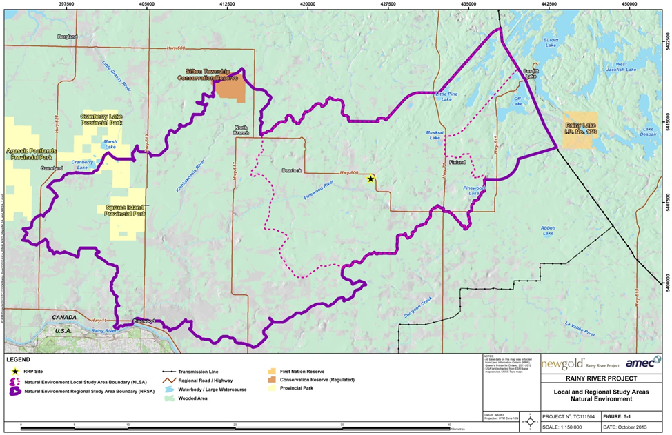
Source: Rainy River EIS, AMEC.
Figure 2: Local and Regional Human Environment Study Areas
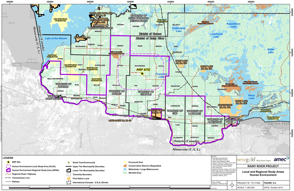
Source: Rainy River EIS, AMEC
1.2.6 Methodology and approach
The Agency reviewed the EIS, additional information requested from the proponent, public and Aboriginal comments received, and the views of federal, provincial and other experts. The Agency examined the predicted changes to the physical environment. The Agency then assessed the environmental effects on chosen VCs in terms of magnitude; geographic extent; duration; frequency; and whether the environmental changes are reversible or irreversible, based on the direct effects from the Project and those effects that may result from predicted changes to the environment.
The Agency's conclusions for the assessment of key VCs are presented and based on the methodology and criteria developed by the proponent in accordance with the Agency's Reference Guide: Determining Whether a Project is Likely to Cause Significant Adverse Environmental Effects.
For each VC, the following criteria were used to evaluate the predicted degree of effects after mitigation:
- Magnitude is a measure of a given key indicator representing the potential effect after mitigation relative to the baseline condition.
- Extent is the geographic area over which an effect will occur.
- Duration is the period of time over which an effect will occur.
- Frequency is how often an effect will occur within a given time period.
- Reversibility is the degree to which the effect can or will be reversed.
- Natural environment context and socio-economic environment context.
Criteria are categorized into three levels. Level I indicates a negligible or limited potential to contribute to a significant effect, Level II represents an intermediate or moderate potential, and Level III indicates a high potential to contribute to a significant effect.
Effects are considered significant if a Level II or III rating is assigned to each of the following attributes: magnitude, geographic extent, duration, and frequency and a Level II or III rating is assigned to either natural environment or socio-economic environment context. Effects are considered insignificant if a Level I rating is assigned to any of the following attributes: magnitude, geographic extent, duration, or frequency; or if a Level I rating is assigned to both natural environment and socio-economic environment contexts. See Appendix B for a summary of the residual effects assessment. The criteria used to determine potential for an adverse environmental effect, such as magnitude, geographic extent, duration, frequency, and reversibility are described in detail in Appendix C.
2 Project Overview
2.1 Location
The Project is located in the Township of Chapple, District of Rainy River, in northwestern Ontario, approximately 65 km northwest of Fort Frances, and 420 km west of Thunder Bay (Figure 3).
2.2 Project Components
Components of the Project (Figure 4) include:
- Open pit. The open pit will be approximately 170 hectares (ha) in surface area and 400 metres (m) deep. Mining is proposed to occur at an ore production capacity of up to 21 000 tonnes per day (tpd) over the life of the mine (with a contingency of up to 20 percent, the ore production capacity of the open pit will be 25 200 tpd).
- Underground mine. The underground mine will be approximately 800 m deep. Mining is proposed to occur at an ore production capacity of 1500 tpd (with a contingency of up to 20 percent, the ore production capacity of the underground mine will be 1800 tpd).
- Overburden stockpile. (approximately 70 to 80 megatonnes (Mt)) and mine rock stockpiles (approximately 350 to 400 Mt). Low grade and high grade ore will be stockpiled during operation;
- Primary crusher and onsite metal mill. Ore will be crushed and processed onsite to produce doré (gold with silver) bars for shipment offsite.
- Tailings management area. The tailings management area will be approximately 800 ha to provide a storage capacity of 115 Mt for tailings over the projected mine life. The maximum projected dam heights are expected to be in the range of 20 to 25 m above grade.
- Water collection, management, distribution, and treatment systems. The water management plan design will rely on recycling water from various constructed ponds for process water and excess water storage uses to reduce the need for fresh water.
- Transmission line. The new 230 kV transmission line will connect to the existing Hydro One Networks Inc. line approximately 17 km northeast of the proposed project site.
- Highway realignment. Realignment of 11 km of the gravel-surfaced Highway 600 will be required, and provincial approvals needed, to fully access the ore body.
- Road development. The new East Access Road will provide continued access to Marr Road properties that would otherwise be disrupted by the project development.
- Aggregate operations. Aggregate is needed to supply construction materials for mine and road development.
- Associate buildings, facilities, and infrastructure. These will include a maintenance garage, a warehouse and administration complex, a fuel storage and refuelling area, laydown area(s), access roads and non-hazardous waste facilities.
- Explosives manufacturing and storage facilities. Explosives will be required in order to extract rock in the open pit and underground mines, and potentially at quarries, if developed.
Figure 3: Project Location
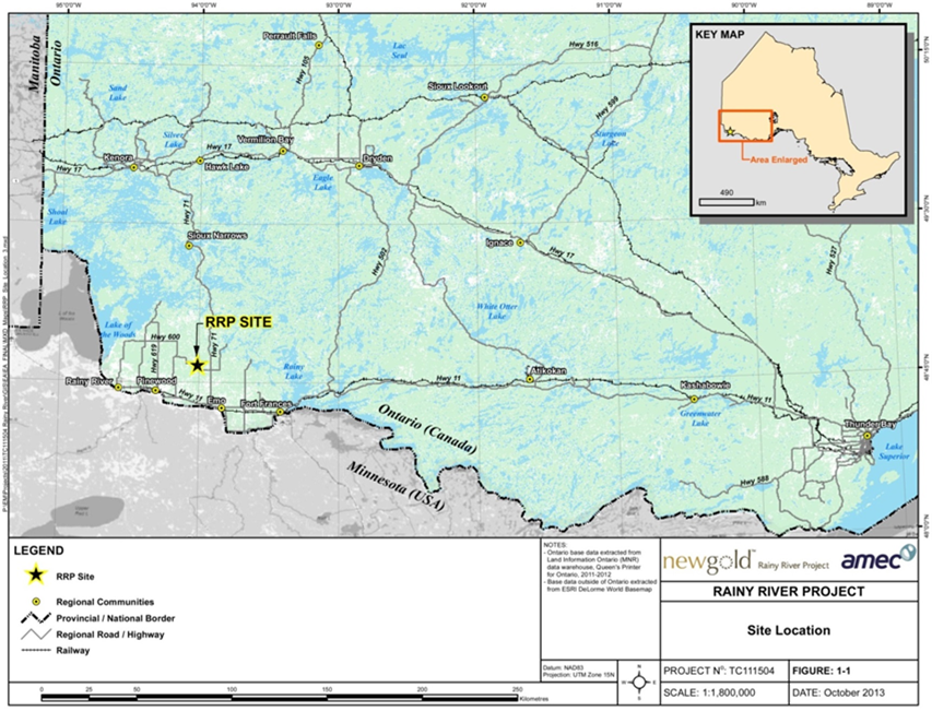
Source: Rainy River EIS, AMEC
Figure 4: Project Components
Source: Rainy River EIS, AMEC
2.3 Project Activities
Key activities associated with construction, operation, decommissioning, and abandonment of the Project are listed below.
Construction phase
- Procurement and movement of construction materials to identified laydown areas;
- Initiation of open pit mine development and portal development for underground mining operations;
- Preparation of onsite mineral waste handling facilities, including tailings management area dams;
- Establishment of watercourse diversions, intake structures, and site drainage works;
- Construction of associated buildings and facilities, and a fuel tank farm;
- Construction of explosives manufacturing and storage facilities;
- Construction of the Highway 600 realignment and Pinewood River crossing, the East Access Road, and redirection of local traffic; and
- Construction and energizing of a 230 kV transmission line.
Operations phase
- Ore and mine rock extraction;
- Ore processing;
- Mineral waste management (overburden, mine rock stockpiles, and tailings);
- Water collection, management, distribution, and treatment; and
- Progressive site reclamation where practical.
Decommissioning phase
- Project infrastructure (e.g., buildings, machinery, equipment) to be removed;
- An onsite demolition landfill for non-hazardous waste generated by mine closure;
- Tailings management area to be saturated to reduce the potential for acid rock drainage and metal leaching by restricting oxygen contact with the tailings surface;
- Overflow spillway(s) to be developed or deepened to ensure drainage of excess runoff in the tailings management area;
- Natural flooding of the open pit and underground mine (potential for enhanced flooding of open pit);
- Removal of the 230 kV transmission line, unless another owner requires its use;
- Closure and reclamation of the various project components (associated buildings, facilities and infrastructure such as a maintenance garage, warehouse and administration complex, fuel storage and refuelling area, laydown area(s), explosives manufacturing and storage facilities);
- Progressive rehabilitation of mine rock and overburden stockpiles where practical (overburden and vegetation for non-potentially acid generating mine rock and multi-layered cover for east mine rock stockpile to control Acid Rock Drainage and Metal Leaching);
- Watercourse diversions and realigned Highway 600 will remain in place; and
- Ongoing environmental monitoring and site management.
Abandonment phase
- Ongoing environmental monitoring and site management until passive flooding of the open pit is complete.
2.4 Schedule
Construction, which the proponent expects to last two years, is proposed to start after completion of the federal and provincial EA processes and once applicable federal and provincial regulatory approvals and permits have been obtained. The operation phase is planned to start in 2016 and continue for 16 years. Active closure and decommissioning are therefore anticipated to begin in 2032 and continue actively for approximately two years. This will be followed by the abandonment phase of approximately 94 years while the open pit is flooding. This will include a final period of environmental monitoring and site management (of less than one year) once the pit is fully flooded in accordance with the mine closure plan filed under theOntario Mining Act to return the leased lands back to the Crown.
3 Project Justification and Alternatives
3.1 Purpose of the Project
The Environmental Impact Statement (EIS) indicates that the purpose of the Project is to meet the strong demand for gold in the global marketplace and that there is a local and regional need in northwestern Ontario for economic development. The proponent expects the Project to have a positive economic influence on the region, providing construction and permanent employment opportunities for a large number of people. The region has experienced recent declines in both employment and population, in large part related to the downturn of the forestry industry.
3.2 Alternative Means of Carrying Out the Project
In accordance with paragraph 19(1)(g) of the Act, the proponent assessed alternative means of carrying out the Project that are technically and economically feasible and the environmental effects of any such alternative means. The proponent considered alternative methods for construction, operation, decommissioning, and abandonment of:
- mining;
- mine water management;
- mine rock and overburden management;
- processing;
- onsite metal mill effluent management;
- tailings management;
- onsite metal mill complex;
- explosives facility;
- aggregates;
- water supply;
- Highway 600 realignment;
- power supply; and
- transmission line rerouting.
The EIS indicates the following performance objectives to distinguish between individual alternatives:
- cost-effectiveness;
- technical applicability and system integrity and reliability;
- ability to service the site effectively;
- effects to the VCs; and
- amenability to reclamation.
The EIS indicates that each performance objective was evaluated using a distinct set of criteria and indicators to help rate the predicted performance of each alternative at a level of preferred, acceptable, or unacceptable. It describes a comparative evaluation of the advantages and disadvantages of each alternative method and takes into account the relative importance of the individual performance objectives listed above. Alternatives rated "unacceptable" in any single performance objective were rejected by the proponent.
An alternatives assessment for disposal of mine waste (i.e. effluent, tailings, waste rock, low grade ore, and overburden) also was undertaken according to Environment Canada's Guidelines for the Assessment of Alternatives for Mine Waste Disposal1 (Environment Canada 2013) which involves a multi-step assessment of the mine waste disposal alternatives based on a multi-criteria decision analysis to identify disposal areas for three types of mine waste (non-potentially acid generating waste rock and overburden, potentially acid generating waste rock, and tailings). This assessment was required because the proposed mine waste disposal areas would directly impact Loslo Creek and Marr Creek. In order to allow for the disposal of mine waste into fish frequented waters, an amendment to Schedule 2 of the Metal Mining Effluent Regulations ( (pursuant to subsection 36(5) of the Fisheries Act) is required.
The EIS also describes the assessment of the alternative methods of decommissioning the open pit, underground mine rock stockpiles, tailings management area, buildings and equipment, and drainage.
Appendix D describes in greater detail the alternative means considered for the project components; their economic and technical feasibility; environmental considerations; and the preferred options in carrying out the Project.
3.2.1 Comments received
Government authorities
The Ministry of Natural Resources and Forestry expressed concerns about the proponent's evaluation of transmission line route alternatives. It requested details about the rationale behind the proponent's selection of its preferred transmission line alternative and public consultation on the provision of any additional information. The proponent provided a supplemental report that outlined additional details and presented figures supporting the selection of its preferred alternative. In addition, the proponent conducted consultations with the public and local Aboriginal communities on the supplemental report.
Aboriginal communities
Aboriginal communities did not express any concern about the alternatives assessment.
Public
Public comments were not received in relation to the alternatives assessment.
Agency analysis and conclusion
The proponent's alternatives assessment considered matters such as managing the footprint of the Project, reducing the quantities of mine rock generated, eliminating or managing direct releases of effluents to the environment, and loss of fish habitat. The Agency notes that the alternatives assessment for mine waste disposal was undertaken according to Environment Canada's Guidelines for the Assessment of Alternatives for Mine Waste Disposal (Environment Canada 2013). The proponent has responded to the Ministry of Natural Resources and Forestry in relation to the siting of the transmission line. The proponent committed to meeting applicable federal and provincial guidelines for the protection of aquatic life, or other scientifically defensible alternatives, in the receiving water body, as well as any site-specific approval requirements established by Environment Canada and the Ministry of the Environment and Climate Change.
The Agency is satisfied that the proponent has sufficiently assessed alternative means of carrying out the project.
4 Consultations Activities and Advice Received
The Agency coordinated public and Aboriginal consultation opportunities, to the extent possible, with the Province of Ontario. For the purposes of the federal environmental assessment (EA), the Agency served as the Crown Consultation Coordinator. The Ministry of the Environment and Climate Change was the lead on consultation activities for the provincial EA, while the Ministry of Northern Development and Mines was the coordinator for provincial Crown consultation activities.
4.1 Aboriginal Consultations
4.1.1 Consultation Aboriginal consultation in the environmental assessment process
The federal government has a duty to consult with Aboriginal groups when it proposes to take an action or make a decision that might adversely affect established or potential Aboriginal or Treaty rights. Where appropriate, the federal government accommodates these interests. The Act facilitates consideration of these impacts on Aboriginal groups by requiring that all federal EAs consider the effect of any project-related effects on their health and socio-economic conditions, physical and cultural heritage, the current use of lands and resources for traditional purposes, and changes to any structure, site or thing that is of historical, archaeological, paleontological or architectural significance to them. Aboriginal consultation is also an important part of good governance and sound policy development and decision making.
The Agency identified 16 Aboriginal groups whose potential or established Aboriginal and Treaty rights could be adversely impacted by the Project:
- Rainy River First Nation
- Naicatchewenin First Nation
- Anishinaabeg of Naongashiing First Nation (Big Island)
- Big Grassy River First Nation
- Ojibways of Onigaming First Nation
- Naotkamegwanning First Nation (Whitefish Bay)
- Métis represented by the Métis Nation of Ontario Region 1 Consultation Committee
- Mitaanjigamiing (Stanjikoming) First Nation
- Couchiching First Nation
- Buffalo Point First Nation
- Northwest Angle #33
- Northwest Angle #37
- Anishinabe of Wauzhushk Onigum (Rat Portage)
- Lac La Croix First Nation
- Seine River First Nation
- Nigigoonsiminikaaning First Nation
The Agency supports Aboriginal participation through its Participant Funding Program. Funds were provided to reimburse eligible expenses of Aboriginal groups that participated in the EA. Nine identified Aboriginal groups applied for and received funding through this program (Whitefish Bay, Big Grassy River , Métis Nation of Ontario Region 1 Consultation Committee, Naicatchewenin, Rainy River, Couchiching, Mitaanjigamiing, Nigigoonsiminikaaning, and Seine River). In total, the Agency awarded $156 540.37 to support Aboriginal participation in the EA.
The Agency consulted all sixteen Aboriginal groups through a variety of methods including phone calls, emails, letters, and in-person meetings. The Agency requested written comments from Aboriginal groups on the project description, the draft environmental impact statement (EIS) Guidelines, the EIS Summary, and the draft EA report (Table 2). The Agency provided regular updates to the Aboriginal groups to keep them informed of key developments and to solicit feedback.
| Document or Subject of Consultation | Dates |
|---|---|
| Summary of the Project Description | September 4, 2012 to September 24, 2012 |
| Draft EIS guidelines | October 19, 2012 to November 19, 2012 |
| EIS/EA report summary | January 17, 2014 to February 17, 2014 |
| Draft EA report | October 9, 2014 to November 8, 2014 |
The Agency held meetings during the review of the EIS with Aboriginal groups, the proponent, and representatives from the province. These sessions provided an opportunity for members of Aboriginal communities (or in some cases, Chief and Council) to hear presentations on the EA and the proponent's EIS and to provide comments. Comments and additional information provided by the proponent were considered in the Agency's analysis.
Potential effects on Aboriginal peoples are discussed in sections 7.3, 7.4 and 7.5. Appendices E and J contain a summary of concerns raised by the Aboriginal groups during the EA process and the proponent's or Agency's responses, as appropriate. All comments have been considered in developing this EA report.
4.1.2 Proponent's Aboriginal consultation and engagement activities
The EIS indicates that the proponent engaged all Aboriginal communities identified by the Agency to discuss issues and offered Aboriginal communities financial support for conducting traditional knowledge and land use studies and reviewing the EIS. The proponent conducted archeological studies and reviewed previous studies related to Aboriginal use of the project site. The proponent also presented information to Aboriginal communities on the fish habitat compensation plan for the loss of habitat resulting from the use of water bodies for mine waste disposal.
The proponent indicated that it signed agreements with some of the Aboriginal groups, including data-sharing protocols, memoranda of understanding, and impact benefit agreements.
The EIS indicates that through funding from the proponent, Pwi-Di-Goo-Zing Ne-Yaa-Zhing Advisory Services, on behalf of Big Grassy River First Nation, Couchiching First Nation, Lac La Croix First Nation, Mitaanjigamiing First Nation, Naicatchewenin First Nation, Rainy River First Nation, and Seine River First Nation, contracted Dillon Consulting Limited to conduct a high-level technical review of the EIS. Elders, youth, hunters, consultation coordinators, and other community knowledge holders from the above-mentioned communities participated in a workshop to help identify the knowledge, values, and priorities held by these First Nations, and to discuss issues, concerns, and opportunities associated with the Project. Comments from the technical review completed on behalf of these First Nations were then considered and incorporated into the EIS and in the Agency's analysis.
4.2 Public Consultation
The Agency provided four opportunities for the public to participate in the EA process:
- An opportunity to comment on the Project Description;
- An opportunity to comment on the draft EIS Guidelines;
- An opportunity to comment on the summary of the proponent's EIS; and
- An opportunity to comment on the draft EA report.
Notices of these opportunities to participate were posted on the Canadian Environmental Assessment Registry Internet Site and advertised through local media.
Groups who participated in the consultations include: the Townships of Emo, Alberton, Dawson, Lake of the Woods, La Vallee, Morley, and Chapple; the Town of Fort Frances; the Rainy River Future Development Corporation; Resolute Products Inc.; and the United Native Friendship Centre.
The Agency supported public participation through its Participant Funding Program. A total of $9 840 was allocated to the Rainy River Soil and Crop Improvement Association.
Hardcopies of the draft EIS Guidelines, EIS Summary, and draft EA report were made available at public viewing centres in the Towns of Barwick, Rainy River, Fort Frances, Emo and Atikokan. During the review of the EIS, the Agency conducted two open houses, one in the Town of Fort Frances and one in Emo. These open houses were held jointly with the proponent, representatives from other federal departments and the provincial government. Over 100 members of the public attended each one. These sessions provided opportunities for members of the public to hear presentations on the EA process, review the proponent's EIS, and provide comments. Those comments were considered in the preparation of this EA report (Appendix F).
4.2.1 Public participation activities by the proponent
The proponent indicated it engaged local residents from the towns of Rainy River and Fort Frances; residents of the townships of Chapple, La Vallee, Alberton, Dawson, Lake of the Woods, and Morley; and other potentially affected or interested stakeholders, including local land owners.
The proponent stated that public consultation activities included information sharing, general consultation with community members, and key stakeholder meetings.
4.3 Participation of Federal and Other Experts
Several federal departments with specialist information or expert knowledge relevant to the Project provided advice pursuant to section 11 of the Act, to help determine whether a federal EA was required. They also participated in the review of the EIS Guidelines and the EIS, and provided input into the preparation of the EA report pursuant to section 20 of the Act.
Fisheries and Oceans Canada has regulatory and statutory responsibilities under the Fisheries Act and provided advice and information related to fish and fish habitat in the context of commercial, recreational or Aboriginal fisheries, and provisions for water flow and fish passage.
Environment Canada has regulatory and statutory responsibilities under the Canadian Environmental Protection Act, 1999 (CEPA), Migratory Birds Convention Act, 1994 (MBCA), Species at Risk Act, and the pollution prevention provisions of the Fisheries Act including the Metal Mining Effluent Regulations. Environment Canada provided advice related to air quality, effluent discharges, geochemistry, water quality and quantity, terrestrial species at risk, international boundary waters, migratory birds, meteorology, climate change, and accidents and malfunctions.
Health Canada provided advice on potential effects on Aboriginal health related to country food, water quality and air quality. Natural Resources Canada has regulatory and statutory responsibilities under the Explosives Act, and provided advice related to groundwater quantity.
At the beginning of the EA process, Transport Canada identified that a Navigable Waters Protection Act (NWPA) permit may be required to enable the Project to proceed. However, under the new Navigation Protection Act, Transport Canada determined that the Pinewood River is not navigable in the area of the proposed crossing for the re-alignment of Hwy 600. The Pinewood River is also excluded from the Schedule of the Navigation Protection Act and an application will not be required.
The Agency notified the Department of Foreign Affairs and International Trade due to the proximity of the project site to the Canada–United States of America border. The Agency also discussed the Project with the International Joint Commission. The International Joint Commission was interested in the Project, but did not raise concerns throughout the EA process.
The Agency and Ontario conducted the federal and provincial EA process cooperatively to the fullest extent possible, which included working closely on the technical review of the EA. The following provincial ministries, while concurrently participating in the provincial EA process, provided advice on the federal EA and have overlapping mandates with the federal authorities: The Ministry of the Environment and Climate Change, Ministry of Northern Development and Mines, and Ministry of Natural Resources and Forestry. The advice of the Ministry of Transportation and the Ministry of Tourism, Culture, and Sport were also considered in the review of the environmental effects, mitigation measures and conclusions.
5 Geographical Setting
5.1 Biophysical Environment
The Project is located in the Township of Chapple, District of Rainy River, in northwestern Ontario. The area has variable, gently undulating terrain and is drained principally by the Pinewood River and its associated minor tributaries.
All aspects of drainage associated with the Project, including water taking and effluent and runoff discharges, occur within an upstream portion of the Pinewood River watershed. Specifically, the project site is drained by four minor creek systems (Clark Creek and Teeple Drain, West Creek, Marr Creek, and Loslo Creek and Cowser Drain; henceforth referred to as the Minor Creek Systems), which flow into Pinewood River. Farther south, the Pinewood River enters Rainy River, which is an international waterway separating Canada (Ontario) from the United States of America (Minnesota).
Data used by the proponent to describe the local climate came from the Environment Canada climate station located approximately 20 km south of the project site at Barwick. Local climate conditions in the area are typical of northwestern Ontario, with a mean annual temperature of 3.2 degrees Celsius (°C), a mean summer high of 18.8°C in July, and a mean winter low of -15.9°C in January. Mean annual average precipitation is 695.7 millimetres (mm), with 80 percent falling as rain and 20 percent as snow. The maximum mean monthly precipitation is 113.8 mm in June and the minimum is 25.1 mm in February. There are no areas of natural and scientific interest or federal lands within or proximal to the general site area. Key wildlife species found within the Natural Environment Local Study Area include White-tailed Deer, moose, and breeding birds.
The project site and surrounding areas are heavily impacted by historical farming and forestry operations. Areas of regenerating abandoned farmland are evident throughout the project site and Natural Environment Local Study Area. Most of the land is cleared, with remaining trees dominated by mixed poplar forest, which is indicative of disturbed lands recovering from past forestry and farming activities or regrowth following past fires (Figure 5). Potential changes to this environment as a result of project activities are assessed in sections 6 and 7
Figure 5: Pinewood River and surroundings, portraying lands recovering from past forestry and farming activities in which the project site is located
Source: Rainy River EIS, AMEC
5.2 Human Environment
The closest local municipalities are: Emo (population 1305; 28 km to the southeast); Rainy River (population 909; 45 km to the southwest); and Fort Frances (population 8103; 50 km to the east-southeast). Naicatchewenin and Rainy River First Nations are the closest reserves and are located approximately 19 km east and southeast, respectively, of the site (Figure 6). Much of the Human Environment Local Study Area has traditionally seen economic activities related to forestry, agriculture, recreation, and tourism. The local economy is struggling due to the decline in forestry activity. The Project is located in a low-density rural area, within which some limited agricultural (mainly cattle and fodder cropping) and logging activities occur and some private residences are found.
Figure 6: Communities and First Nation Reserves surrounding the project site
Source: Rainy River EIS, AMEC
6 Predicted Changes to the Environment
6.1 Atmospheric Environment
6.1.1 Baseline by proponent
Air quality baseline by proponent
The atmospheric environment baseline includes a description of both air quality and the acoustic (sound) environment. The project site is in a rural area away from major industrial emission sources. Local sources of air emissions include road traffic, agriculture, an engineered wood particle board mill located 30 km away, and drilling associated with mineral exploration activities.
The baseline air quality at the Environment Canada and Ministry of the Environment and Climate Change monitoring stations meets the Ontario Ambient Air Quality Criteria, which are generally more stringent than the Canadian National Ambient Air Quality Objectives. Air quality monitoring conducted at the project site focused on potential contaminants of concern, including particulate matter also known as total suspended particulate, and metals. Table 3 provides a baseline summary
Acoustic environment baseline by proponent
Sound data were collected at residential sites, at locations selected for wildlife habitat sensitivity, and at monitoring stations covering a wider area around the project site. Measured baseline sound levels were indicated to be below the sound limits, as per the Ministry of the Environment and Climate Change NPC-300 noise guidelines for Class 3 (rural) areas, of 45 A?weighted decibels (dBA) for daytime (7:00 to 19:00) and 40 dBA for evening and nighttime (19:00 to 7:00).
6.1.2 Changes to atmospheric environment predicted by proponent
Changes to air quality
Predicting the changes to the atmospheric environment involved evaluating the main sources of air emissions from the construction, operation, and decommissioning phases of the Project. The model for air quality was based on maximum predicted ground level air concentrations in the Natural Environment Local Study Area during operation, both before and after, with the application of mitigation measures. The model was based on conservative estimates (i.e., if all sources are active at their maximum output at all times). The model showed levels of total suspended particulate and fine particulate matter may infrequently exceed Ambient Air Quality Criteria at the project site boundary. Exceedances of contaminants of potential concern due to the Project are predicted to be infrequent at the project site boundary during operation (Table 3).
Emissions sources during operation were: blasting; material handling in the open pit; dust from crushing; road dust emissions; dust from managing mine rock, ore and overburden; concrete batching; underground mining activities; gold ore processing; and exhaust from back-up power generation. Fugitive dust and contaminant emissions have the highest potential for causing adverse offsite effects during operation.
Sulphur dioxide emissions occur primarily from the cyanide destruction system in the onsite metal mill; releases of hydrogen cyanide will be from the leaching process; and releases of nitrogen oxides (NOx) will be from blasting and propane combustion. Key metals were modelled with the assumption that dust is of the same composition as the ore or mine rock. The predicted concentrations of key metals at the project site boundary were all shown to be below their respective Ambient Air Quality Criteria limits. Table 3 provides a comparison of Ambient Air Quality Criteria limits, baselines and modelled impacts.
| Air Quality Background Concentration (µg/m3) | Air Quality Background + Modeled Impact Concentration (µg/m3) | Ambient Air Quality Criteria Limits (µg/m3) | |
|---|---|---|---|
| Particulate matter as total suspended particulate | 39.0 | 125.0 | 120 |
| Fine particulate matter (PM2.5) | 9.8 | 33.7 | 30 |
| Sulphur oxides, mainly as sulphur dioxide (SO2) | 3.0 | 12.3 | 275 |
| Nitrogen oxides (NOx) | 11.0 | 37.7 | 200 |
| Key Metals | |||
| Arsenic (As)2 | no data | 0.012 | 0.3 |
| Cadmium (Cd) | 0.0022 | 0.004 | 0.025 |
| Lead (Pb) | 0.010 | 0.029 | 0.5 |
| Mercury (Hg) | 0.0017 | 0.0017 | 0.5 |
| Hydrogen cyanide3 | no data | 1.40 | 8 |
Adapted from Rainy River EIS, AMEC
The proponent proposed mitigation measures to mitigate the effects on air quality (Appendix A). After mitigation, the residual effects on air quality were predicted to be confined to the project site; continuous through mine construction, operation, and decommissioning; and reversible following decommissioning. The proponent indicated that with mitigation, concentrations of contaminants of potential concern are predicted to be below Ambient Air Quality Criteria limits for emissions during all phases of the Project, with only infrequent potential exceedances of Ambient Air Quality Criteria for total suspended particulate and fine particulate matter at the project site boundary during operation.
Changes to acoustic environment
Sound emissions will be greatest during the operation phase and most notable in areas of concentrated heavy equipment operation associated with the open pit, stockpiling, onsite metal mill, and crusher operations. Sound disturbances will have lesser adverse effects in areas of low traffic, such as the proposed transmission line and the tailings management area. The results of the sound contour modelling indicate that the sound levels are not expected to exceed Ministry of the Environment and Climate Change NPC-300 noise guidelines.
The proponent proposed mitigation measures to mitigate the effects on sound levels (Appendix A). After mitigation, the residual effects on noise were predicted to be confined to the project site; continuous through mine construction and operation; and reversible at decommissioning. The modelled sound contours for the project site and surrounding receptors in the Natural Environment Local Study Area for the two worst case scenarios (2015 and 2020) demonstrate compliance with applicable Ministry of the Environment and Climate Change NPC-300 noise guidelines.
6.2 Water Quantity (Levels and Flows)
6.2.1 Baseline by proponent
The Minor Creek Systems, as defined in section 5.1, which drain the project site, are generally low gradient, low energy systems with wide, densely vegetated grass and sedge dominated floodplains, with frequent naturally impounded water bodies such as beaver ponds and related log jams. The Minor Creek Systems flow into the Pinewood River and make up part of the total watershed area of the Pinewood River, which is 57 550 ha. The Pinewood River has limited baseflow due to the prevalence of clay substrates in the Natural Environment Local Study Area and low groundwater recharge rates. As a result, the River can experience extreme low to zero flow conditions in the late summer and early fall during drought years and during mid to late winter.
6.2.2 Changes to water quantity predicted by proponent
Construction
Temporary Water Taking
The proponent proposes to take water from the Pinewood River watershed during construction to build an initial water inventory for project start-up. This would be achieved, in part, through the capturing and holding of site runoff from the tailings management area, water management pond, and mine rock pond catchments, which would otherwise enter the Pinewood River. A water intake structure would also be constructed downstream of McCallum Creek, where there is substantial increase in total river flow due to the inflow of two major tributaries.
The water taking would result in an amount not greater than 20 percent flow reduction in the Pinewood River from April to June and 15 percent reduction at other times of the year, as measured below McCallum Creek. The actual flow reduction in the Pinewood River would begin upstream of that, prior to the construction of the West Creek Diversion Channel, due to the holding of site runoff which would otherwise enter the river via the Minor Creek Systems.
Minor Creek Systems
Potential effects on creeks are limited to the Minor Creek Systems within the Natural Environment Local Study Area, where the creeks will be altered and disrupted by mine components (Figure 7), during all project phases including abandonment. Following construction of the project site, the Minor Creek Systems are referred to as the Modified Mine Creek Systems, which is defined as the remainder of the pre-disturbance Minor Creek Systems and any new channels or ponds, including West Creek Diversion Channel; Stockpile Pond Diversion Channel; Clark Creek Diversion Channel; West Creek Pond; Stockpile Pond; Clark Creek Pond; Teeple Road Pond; Loslo Creek downstream of the constructed wetland; and the unidentified creek linking Teeple Pond to Pinewood River. The effects of associated habitat loss on fish and fish habitat are discussed further in section 7.1. The upstream portions of these creeks will require flow diversion or interception to prevent upstream flows from interacting with the project site. Potential effects on creek flows, and the resulting effects on the Pinewood River, will vary from creek to creek (Table 4).
| Change to Creek | Redirection of Creek Flow | Effect on Pinewood River Flows | |
|---|---|---|---|
| Clark Creek and Teeple Drain |
|
|
|
| West Creek |
|
|
|
| Marr Creek |
|
|
|
| Loslo Creek and Cowser Drain |
|
|
|
Adapted from Rainy River EIS, AMEC
Pinewood River
As a result of the changes to the Minor Creek Systems described above, the locations of creek inflows to the Pinewood River will be modified during all project phases, including abandonment. The resulting flow reduction in the Pinewood River ranges from 8.1 to 34.2 percent between Clark Creek and Loslo Creek and by 8 percent between Loslo Creek and the tailings management area pipeline discharge point downstream of the McCallum Creek outflow.
Below the McCallum Creek outflow, Pinewood River flow increases substantially, as the natural watershed is expanded by McCallum Creek and Tait Creek. At the pipeline discharge point, Pinewood River flow will be influenced negatively by upstream runoff losses and positively by water released back through the constructed wetland, the West Creek Diversion Channel, and the discharge pipe.
Operation
Losses from the water management system during operation include water stored permanently in the tailings management area, evaporation from the onsite metal mill, and water used for dust suppression. A small amount of water (100-200 m3 per day) will be taken from West Creek Pond for potable water. Despite recycling and water losses to storage in the system, a surplus of treated water is expected during operation, due to additions from ground water intercepted by mine workings and the development of enhanced site runoff conditions.
The proponent owns the majority of the water supply wells within the zone of influence of open pit dewatering. The proponent predicted that reduction in groundwater flow is not expected to affect flows in the Pinewood River or the Minor Creek Systems.
Decommissioning and Abandonment
Modifications made to the Minor Creek Systems and the constructed diversion channels during construction will be maintained during decommissioning and abandonment, resulting in continued flow reductions in the Pinewood River between Clark and Loslo Creeks.
Additional water taking from the Pinewood River is proposed, with government oversight, during decommissioning, including the holding of site runoff and tailings management area outflows, to augment the flooding of the tailings management area and filling of the pit. Flooding of the pit is expected to take several decades, depending on the quantity of runoff that is intercepted and held. Water management during tailings management area flooding and open pit filling could result in additional reductions in Pinewood River flows until the open pit is filled.
The proponent proposed mitigation measures to mitigate the effects on water quantity (Appendix A). After mitigation, the residual effects on water quantity were predicted to be confined to the project site; long-term; continuous through mine construction, operation, and decommissioning; and irreversible. The proponent indicated that the effects, however, will be compensated and as such, are not of concern.
6.3 Water Quality
6.3.1 Baseline by proponent
Canadian Environmental Quality Guidelines4 and Provincial Water Quality Objectives5 are values set by the federal and provincial governments respectively, and are considered protective of all forms of aquatic life, including the most sensitive species for an indefinite period of exposure with included safety factors. It is possible for certain parameters to exceed Canadian Environmental Quality Guidelines and Provincial Water Quality Objectives values in the background environmental baseline condition, even in areas that are completely undisturbed.
Surface water quality monitoring data for the Project indicate that the baseline exceeded levels relative to Canadian Environmental Quality Guidelines and Provincial Water Quality Objectives for the following parameters: copper (mainly Canadian Environmental Quality Guidelines), arsenic, lead, nickel, and zinc. The baseline for groundwater also exceeded Canadian Environmental Quality Guidelines for arsenic, iron and cadmium and Provincial Water Quality Objectives parameters for cobalt and iron. The ability of these parameters to cause a health risk to fish, wildlife, and humans is a function of release rates, exposure pathways, and organism presence and sensitivity.
Figure 7: Aquatic Habitat Displaced by Mine Features
Source: Rainy River EIS, AMEC
The ore and a substantive portion of the waste mine rock are potentially acid generating, which creates the risk of acid rock drainage and metal leaching in the Natural Environment Local Study Area. It is estimated that approximately 44 percent of the waste material within the future pit would be potentially acid generating.
6.3.2 Changes to water quality predicted by proponent
Changes to water quality in the Pinewood River and the Modified Minor Creek Systems could arise due to contaminant sources, such as mine water from the open pit and underground mine, water associated with the treated tailings from the process plant (Table 5 lists the major contaminants in the treated effluent), and runoff and seepage from the tailings management area and stock piles.
The proposed water management plan includes six primary constructed ponds for water management (Figure 8): tailings management area pond, water management pond, water discharge pond, mine rock pond, and sediment ponds #1 and #2.
All contact water, including mine water from the open pit and underground mine, will flow directly or indirectly to one of these ponds. The tailings management area and stockpiles will incorporate perimeter ditching to intercept and redirect any seepage to the water treatment systems and subsequently to the final discharge points.
Four final discharge points for the operation phase are proposed (Figure 8):
- the constructed wetland, which will discharge into Loslo Creek;
- the pipeline, which will discharge directly into Pinewood River downstream of the McCallum Creek outflow;
- sediment pond #1, which will discharge into the West Creek Diversion Channel; and
- sediment pond #2, which will discharge into Loslo Creek.
| Parameter | Cyanide Destruction 60-day Aging Test Results (mg/L) | Water Quality Standards | |
|---|---|---|---|
| (Provincial Water Quality Objectives (mg/L) | Canadian Environmental Quality Guidelines (mg/L) | ||
| Cyanide (total) | <0.01 | ------------- | ------------- |
| Cyanide (free) | <0.01 | 0.005 | 0.005 |
| Arsenic | 0.003 | 0.1 0.005 - interim | 0.005 |
| Copper | 0.012 | 0.005 at hardness > 20 mg/L calcium carbonate | 0.004 at hardness > 180 mg/L calcium carbonate |
| Nickel | 0.003 | 0.025 | 0.150 at hardness >180 mg/L CaCO3 |
| Lead | 0.0005 | 0.005 at hardness > 80 mg/L calcium carbonate | 0.007 at hardness >180 mg/L calcium carbonate |
| Zinc | 0.086 | 0.030 0.020 - interim | 0.030 |
| Un-ionized ammonia (NH3-U) | 0.153 | 0.020 | 0.019 |
Adapted from Rainy River EIS, AMEC
Figure 8: Water Management Ponds and Final Effluent Discharge Points
Source: Rainy River EIS, AMEC
Appendix G summarizes the various water bodies associated with the water management plan or project site, as described in the Environmental Impact Statement (EIS), and differentiates between those water bodies that are part of a water treatment and those forming part of a freshwater system.
The proponent proposed mitigation measures to reduce the effects on water quality (Appendix A). After mitigation, the residual effects on water quality were predicted to be confined to the project site, but long-term and irreversible. The proponent indicated however, that the effects will be compensated and as such are not of concern. The EIS indicates that treated runoff and seepage discharges will be in compliance with the federal Metal Mining Effluent Regulations Schedule 4 limits and the Ministry of the Environment and Climate Change's Environmental Compliance Approval and Provincial Water Quality Objectives or site-specific criteria at the mixing zone boundary will be met. The river system is sufficiently adaptable such that if unexpected concerns arise, adaptive management techniques will be applied to optimize the water management plan.
6.4 Terrestrial Landscape
6.4.1 Baseline by proponent
The Natural Environment Local Study Area encompasses a variety of terrestrial habitats with habitat overlap which is reflected in the aerial extent coverage reported (Table 6). Also, many of the woodland habitat areas have been harvested in the past and are in a state of regeneration. Two provincially rare plant species, Field Sedge and New England Violet, were identified in the Natural Environment Local Study Area, both within woodland habitats. Field Sedge was abundant and widespread within hardwood forests in the Natural Environment Local Study Area. The New England Violet was identified in coniferous forests and coniferous swamps within the northern and northeastern parts of the Natural Environment Local Study Area.
6.4.2 Changes to terrestrial landscape predicted by proponent
Clearing will mostly affect vegetation community types that are common throughout the Natural Environment Local Study Area and Natural Environment Regional Study Area (Table 6). Most habitat lost will be woodland (1475.3 ha, or 7.3 percent of woodland habitat within the Natural Environment Local Study Area) and will occur during construction of the tailings management area, overburden stockpile, open pit, and mine rock stockpiles. Most of the affected hardwood forests are relatively young due to forestry activities, and provide deer browse and habitat for woodland breeding birds, like Eastern Whip-poor-will and Golden-winged Warbler. Coniferous forests provide late winter moose habitat and also support woodland breeding bird species. The project site largely avoids more mature hardwood forests, which are the best candidate habitats for bat roosting colonies.
Loss of wetland habitat (291.8 ha, or 9.5 percent of wetland habitat within the Natural Environment Local Study Area) will occur during construction of the tailings management area, overburden rock stockpile, and open pit. No bog communities will be impacted directly. The removal of wetland habitat within the Natural Environment Local Study Area will also impact 19 ha of open water habitat in relation to the Minor Creek Systems. Wetlands in the Natural Environment Local Study Area provide habitat for Snapping Turtles (section 7.7), and waterfowl like Trumpeter Swans (section 7.2).
Open country habitat loss (399 ha, or 15.3 percent of open country habitat within the Natural Environment Local Study Area) will occur during construction of the tailings management area, overburden and west mine rock stockpile, open pit, east mine rock stockpile, and onsite metal mill site. Open country habitats may support area-sensitive breeding bird communities like Bobolink, and provide foraging habitat for the Barn Swallow. Typically, these sites are created by human activity, and continue to be habitually disturbed.
Rock and mineral barren habitat will be cleared (10.9 ha or 14.2 percent of rock and mineral barren habitat within the Natural Environment Local Study Area). Rock and mineral barren habitat communities may support area sensitive breeding communities like Common Nighthawk and may provide habitat for Eastern Whip-poor-wills.
| Habitat | Sub-habitat | Dominant Species | Aerial Extent in Natural Environment Local Study Area (ha) | Loss due to Clearing (ha) |
|---|---|---|---|---|
| Woodland |
|
|
12 961.3 | 1133.9 (8.7%) |
|
|
2637.1 | 118.3 (4.5%) | |
|
|
4612.4 | 223.1 (4.8%) | |
| Total | 20 210.8 | 1475.3 (7.3%) | ||
| Wetland |
|
|
1239.7 | 138.8 (11.2%) |
|
|
954.8 | 123.3 (12.9%) | |
|
|
865.2 | 29.7 (3.4%) | |
|
|
2.2 | 0 | |
| Total | 3061.9 | 291.8 (9.5%) | ||
| Open country |
|
|
2044.3 | 286.7 (14%) |
|
|
569.5 | 112.3 (19.7%) | |
| Total | 2613.8 | 399 (15.3%) | ||
| Rock and Mineral Barren |
|
|
77 | 10.9 (14.2%) |
| Total | 77 | 10.9 (14.2%) | ||
Adapted from Rainy River EIS, AMEC
Two of three habitat locations at the project site supporting New England Violet and one of two habitat locations supporting Field Sedge will be cleared. The New England Violet and the Field Sedge are known to have medicinal value for Aboriginal communities.
An increase in vehicle traffic at the project site will result in increased dust generation and deposition on vegetation. Dust can affect photosynthesis, respiration, transpiration, allow the penetration of phytotoxic gaseous pollutants, and may result in some visible injury symptoms and generally decrease plant productivity. Vegetation communities likely to be most affected by dust deposition are located alongside the roads on which haul trucks will be travelling, i.e., between the open pit, onsite metal mill, and stock pile areas. These vegetation communities are already subject to a degree of dust exposure, as the roads connecting these components are located where Roen Road and Highway 600 currently exist. A fugitive dust best management practices plan will be implemented at the start of mine construction as identified in section 7.4.
The proponent proposed mitigation measures to reduce the effects on the terrestrial landscape (Appendix A). After mitigation, the residual effects on the terrestrial landscape were predicted to be long-term continuing through mine construction and operation, however, reversible or largely reversible following mine decommissioning and confined to the project site. The proponent concluded that the change to the terrestrial landscape was not a concern after mitigation was applied.
7 Predicted Effects on Valued Components
7.1 Fish and Fish Habitat
7.1.1 Baseline by proponent
The Pinewood River flows downstream to the Rainy River. The Pinewood River and the Minor Creek Systems consist of different habitats that support small- and large-bodied fish.
The Pinewood River has typical widths of 10 to 15 m within the general vicinity of the project area with wider sections associated with beaver impoundments and drowned oxbows. Substrates consist of clays and silt with some detritus, while gravel, rock, or cobble substrates are sparse and contribute little to no in-stream habitat or cover for fish. Turbidity is high because of erosion of the clay and silt substrates and agricultural drainage inputs. Beaver dams are frequent and present periodic obstacles to fish passage.
The Minor Creek Systems, described in section 5.1, exhibit summer widths of 0.5 to 3 m, except in locations impounded by beaver dams. They are generally low gradient, low energy systems characterized by single to braided diffuse channels with wide, densely vegetated grass and sedge dominated floodplains.
Within the Natural Environment Local Study Area, large-bodied fish (Northern Pike, Brown Bullhead, and White Sucker) were found exclusively in the Pinewood River, with the exception of White Sucker, which is also found in Loslo and Clark Creeks. Walleye and Yellow Perch occur further downstream in the Pinewood River, but not in the project site. Lake Sturgeon is known to occur in the Rainy River and three were located near the mouth of the Pinewood River, downstream of the project site. Small-bodied fish are abundant within the Pinewood River watershed. Small-bodied fish communities within the habitats of the Minor Creek Systems are typically warm water and cool water baitfish and include Brook Stickleback, Central Mudminnow, and Brassy Minnow.
7.1.2 Effects predicted by proponent
Potential adverse effects are discussed with respect to fish and fish habitat in general rather than by individual species. The Project will result in environmental effects on fish from the alteration and disruption of existing fish habitat, and from changes in water quality and quantity.
The direct loss of fish habitat in the Minor Creek Systems will occur from development of the tailings management area, open pit, overburden and mine rock stockpiles, road crossings, and pipeline crossings and outlets (Table 7). The Project will also result in the alteration of fish habitat in Clark Creek and West Creek, through diversion of the creeks around the mine infrastructure (Figure 7). The water bodies which are altered or disrupted must be added to Schedule 2 of the Metal Mining Effluent Regulations to allow their use for mine waste disposal.
| Creek | Total Habitat Available (ha) | Total Area Lost (Metal Mining Effluent Regulations, Sub-section 27.1) (ha) | Total Area Lost (Fisheries Act, section 35(2)) (ha) | Habitat Disturbed by the Project (ha) |
|---|---|---|---|---|
| Clark Creek | 5.32 | 0 | 2.1582 | 2.1582 |
| Loslo Creek | 19.77 | 19.0781 | 0 | 19.0781 |
| Marr Creek | 2.71 | 2.2408 | 0.441 | 2.6818 |
| West Creek | 9.49 | 0 | 1.9923 | 1.9923 |
| Total | 37.28 | 21.3189 | 4.5915 | 25.9104 |
Adapted from Rainy River EIS, AMEC
Changes to water quality could occur from tailings and rock stockpile management, and treated effluent discharge into the Pinewood River. Also, there may be effects on habitat due to flow reductions in the Pinewood River from water taking, groundwater interception, and creek runoff collection. Following decommissioning, it will be possible to direct a major portion of project site catchment flows directly to the Pinewood River, including runoff from the reclaimed tailings management area and portions of the reclaimed stockpiles.
The physical effects impacting the Pinewood River are minor and relate to the construction of a new crossing of the realigned Highway 600 and a flood protection berm that will protect the open pit from flooding during 100-year and greater storm events. The new crossing will consist of a multi-cell culvert or spanning structure, which was planned using the Ministry of Transportation Environmental Guide for Fish and Fish Habitat. It will be designed in accordance with Ministry of Transportation's Highway Drainage Design Standards, which ensures that fish passage will not be impeded by maintaining existing velocities, depths, and gradients.
Adverse effects on fish habitat relating to site runoff capture, management, and discharge are not expected by the proponent. Some flow reductions are expected by the proponent in the Pinewood River upstream of the McCallum Creek outflow, as described in section 6.2.
7.1.3 Comments received
Government Authorities
Environment Canada, Fisheries and Oceans Canada, Ministry of Natural Resources and Forestry and the Ministry of the Environment and Climate Change expressed concerns about the plan to reduce flow by 20 percent during the spring and up to 15 percent during the remaining open water period to build water inventory for project start-up and how this would affect the wetted width of the river. The proponent will only take water for a maximum of two years during mine construction as this is necessary for the viability of the Project. The proponent's modelling shows that a decrease in flow of 20 percent, which is expected to occur only during the two years of construction, will result in a decrease of less than 10 percent for wetted width and depth.
Fisheries and Oceans Canada and Ministry of Natural Resources and Forestry expressed concerns about permanent flow reduction in the Pinewood River. The proponent confirms that the West Creek and Marr Creek diversions will result in permanent flow reductions in that section of the Pinewood River. The proponent indicates that Pinewood River is a low gradient system and effectively maintains areas of fish habitat, even under very low flow conditions.
Federal and provincial authorities expressed concern about the ability of the proponent to perpetually maintain the tailings management area in a saturated state to prevent the generation of acid rock drainage and metal leaching (Acid Rock Drainage and Metal Leaching).
Federal and provincial authorities expressed concern about potentially acid generating (potentially acid generating) material being used for construction, especially for road construction. The proponent has committed not to use potentially acid generating for road construction. The proponent will use potentially acid generating material in a controlled manner, where saturated conditions can be maintained.
Ministry of the Environment and Climate Change expressed concern about the modified effluent criteria proposed by the proponent. Ministry of the Environment and Climate Change considered the fact that some Provincial Water Quality Objectives parameters do not take more recent toxicological information into account, and that some jurisdictions have more recently updated surface water criteria based on water hardness as a toxicity modifier. As a result, Ministry of the Environment and Climate Change proposed site-specific effluent criteria that are achievable by the proponent after effluent treatment and extended aging processes. The proponent will adhere to Ministry of the Environment and Climate Change site-specific criteria which will be confirmed in the final Ministry of the Environment and Climate Change Environmental Compliance Approval for effluent from the proposed discharge points into the Pinewood River. The proponent will discharge effluents into the Pinewood River and the Modified Minor Creek Systems in a manner that will achieve rapid mixing so that site-specific criteria for water quality will be achieved at the boundary of the mixing zone. Current modelling results indicate that the mixing zone is 30 m from the discharge point. If future operational monitoring shows that effective receiver mixing is not attained, additional measures will be implemented to enhance mixing to a level which is acceptable to the Ministry of the Environment and Climate Change.
Aboriginal communities
Aboriginal communities expressed concerns about water quality and quantity, impacts on fish populations due to water treatment processes, outlet locations for water returned back to the environment, and expected flow rates.
They were concerned about effects on fish and fish habitat at the project site and downstream. A request was made to study species at various trophic levels. To better accommodate an ecosystem-based approach, the proponent selected its valued components (VCs) by focusing on habitats, features, specific species groups, and related system interactions, rather than individual species.
They expressed concerns about the possibility of acid rock drainage and metal leaching from the tailings management area and waste rock stockpiles. The proponent has designed the Project and the mine closure plan with acid rock drainage prevention and mitigation measures to avoid acid rock drainage from waste rock stockpiles and the tailings management area during operation, decommissioning, and abandonment.
They expressed concerns about the use of site-specific water quality objectives and the ability of the constructed wetlands to accommodate the effluent discharge flows, meet water quality values, and prevent the potential for mercury pollution. The proponent has designed the constructed wetland to polish the effluent from the tailings management area. This effluent is anticipated to be high quality, and mercury concentrations are likely to be similar to those of Pinewood River background concentrations. No appreciable change in mercury levels is expected in the Pinewood River.
Aboriginal communities expressed concerns about the use of chemicals as a long-term water treatment option. The proponent has designed the Project without the use of long-term chemical treatment of water at decommissioning. Passive treatment measures, such as periodic fertilization of the upper pit lake water column during abandonment, may be used.
They also expressed concerns about the water quality of the pit overflow discharge during abandonment. The proponent will protect aquatic life, when taking hardness modifiers into consideration, with the open pit overflow discharge. The proponent will continue studies to optimize final pit overflow water quality.
Public
The public raised general concerns related to impacts on fish and fish habitat.
7.1.4 Residual environmental effects predicted by proponent
The proponent committed to a number of mitigation measures to mitigate the effects to fish and fish habitat, some of which were in response to comments or concerns raised (Appendix A). The Agency identified those measures required to prevent significant adverse effects (subsection 7.1.5).
Residual effects on fish and fish habitat will result from the alteration and disruption of existing fish habitat, and from changes in water quality and quantity, and are predicted to be minor in magnitude and confined to the project site. They will be long-term, continuing throughout mine construction, operation, decommissioning, and abandonment and irreversible. The Project will result in the loss of 25.87 ha of creek and agricultural drain habitat. However, the fish habitat offsetting and compensation plans will offset the unavoidable effects of the Project on fish habitat. The river system is sufficiently adaptable, so that if unexpected concerns arise during mine operation or following closure, an adaptive management plan can be implemented at the site.
The proponent considered the overall adverse effects on fish and fish habitat as not likely to be significant.
7.1.5 Mitigation measures
The Agency has identified key mitigation measures required to prevent significant adverse effects on fish and fish habitat:
- Manage fish and fish habitat by:
- Implementing a fish habitat compensation plan7, in accordance with Metal Mining Effluent Regulations, to offset the loss of fish habitat resulting from the deposit of deleterious substances into water bodies frequented by fish. This compensation plan will involve the creation of fish habitat through the creation of the West Creek Diversion Channel, the Stockpile Pond Diversion Channel, the Clark Creek Diversion Channel, the West Creek Pond, Stockpile Pond and the Clark Creek Pond (Figure 7) for losses associated with the removal of creeks at the project site.
- Implementing a fish habitat offsetting plan8 to offset serious harm to fish, including any permanent alteration to, or destruction of, fish habitat, in accordance with the Fisheries Act. This offsetting plan will involve watershed-based enhancements (fencing off cattle, offline cattle watering sources, and channel and riparian zone restoration) and the creation of fish habitat through establishing Teeple Road Pond.
- Designing and constructing new road watercourse crossings for the realignment of Highway 600 to allow for fish passage and meet the Ministry of Transportation Environmental Guide for Fish and Fish Habitat and the Ministry of Transportation Highway Drainage Design Standards.
- Following the Fisheries and Oceans Canada Freshwater Intake End-of-Pipe Guidelines for water intakes.
- Minimize changes to water flows and levels in the Pinewood River, the Minor Creek Systems and the Modified Minor Creek Systems such that adverse effects to fish and fish habitat are reduced by:
- Establishing flow and level requirements for the protection of fisheries in the Pinewood River, in consultation with the appropriate government authorities, and not taking water from the Pinewood River when flows are below the minimum threshold set by Ontario.
- Designing and implementing the water management plan to achieve these flow and level requirements during all applicable project phases, including recycling water onsite for ore processing from the tailings management area and water management ponds, capturing and returning groundwater to the Pinewood River, optimizing the timing, position and quality of final effluent discharges, and balancing water needs during open pit filling at decommissioning.
- Manage quality of water discharged into the Pinewood River and the Modified Minor Creek Systems from the project site by:
- Treating effluent prior to discharge to the environment to comply with the Ministry of the Environment and Climate Change Environmental Compliance Approval, the Fisheries Act, and federal Metal Mining Effluent Regulations Schedule 4 limits at all times.
- Designing and implementing the water management plan to achieve these compliance limits during construction and operation. This includes treatment of effluent prior to discharge to the environment; treatment of tailings slurry to break down cyanide and precipitate heavy metals prior to discharge to the tailings management area; collection of runoff and seepage in ditches; diversion of contaminated site contact water directly or indirectly into the tailings management area or water management facilities for release via final discharge points; use of a constructed wetland with a control structure for final effluent polishing of all discharge except any effluent discharged directly through the pipeline; and placement of secondary containment at pipelines that cross West Creek Channel Diversion to prevent accidental discharge of effluent.
- Control acid rock drainage and metal leaching throughout the project lifecycle by:
- Lining the former Clark Creek channel (under the east mine rock stockpile) with non-potentially acid generating material to provide drainage of effluent, sorting waste rock into non-potentially acid generating and potentially acid generating rock stockpiles through the development and implementation of a detailed mine rock segregation program using provincial criteria for determining potentially acid generating material, using potentially acid generating material for construction only where saturated conditions can be maintained, and placing an engineered cover over the east mine rock stockpile, and any remaining ore stockpiles, at the decommissioning phase.
- Covering the tailings beach with overburden, and the tailings with two metres of water, maintaining the tailings in a perpetually saturated state, and controlling water quality in the open pit lake during the decommissioning and abandonment phases.
- Filling the open pit as rapidly as practicable during the decommissioning and abandonment phases, using all available means, including directing drainage from the east mine rock stockpile into the pit.
- Treating water in the upper water column of the open pit lake, to avoid release of contaminated water, and ensure passive outflow does not exceed regulatory standards during the decommissioning and abandonment phases.
- Designing and constructing the perimeter ditching around the east mine rock stockpile and low grade ore stockpile to accommodate a 100-year flood event.
The proponent has committed to implement additional mitigation measures as identified in Appendix A: Part 2.
7.1.6 Agency analysis and conclusion
The Project is predicted to cause effects on fish from the alteration and disruption of existing fish habitat, and from changes in water quality and quantity. The Project will cause direct loss and alteration of fish and fish habitat in the Minor Creek Systems. There may be changes in water levels and flow as a result of alteration and disruption of the Minor Creek Systems and water taking from the Pinewood River. Impacts to surface water as a result of dewatering activities are expected to be minimal as groundwater is not a major contributor to surface water flows. Changes to water quality may occur from tailings and rock stockpile management, and treated effluent discharge into the Pinewood River. The proponent plans to mitigate the effects to fish and fish habitat by implementing fish habitat offsetting and compensation plans to offset the loss of fish habitat. The effects to water flow will be mitigated by capturing and returning groundwater to the Pinewood River to minimize potential flow effects on the river, particularly during low flow periods; restricting water taking from the Pinewood River to the first two years of the construction phase; and implementing a water management plan to reduce the effects related to water quantity and ultimately on fish habitat. Also, the proponent plans to mitigate effects to water quality by implementing the water management plan which includes using potentially acid generating material for construction only where saturated conditions can be maintained and placing an engineered cover over the east mine rock stockpile at decommissioning; recycling the treated onsite metal mill effluent discharge into the tailings management area; and reusing the contact water collected from the various stockpile and seepage collection systems. The Agency is satisfied that the proponent has responded to government authorities and Aboriginal comments, including by establishing minimum flow requirements for the protection of fisheries in the Pinewood River. The Agency considers the residual effects to be minor and localized with the implementation of the fish habitat offsetting and compensation plans, the proponent's water management plan, and the proponent's commitment to develop minimum flow thresholds to protect aquatic habitats, in consultation with Ministry of the Environment and Climate Change and Fisheries and Oceans Canada.
The Agency concludes that the Project is not likely to cause significant adverse environmental effects on fish and fish habitat and water quantity, taking into account the implementation of mitigation measures.
7.2 Migratory Birds
7.2.1 Baseline by proponent
The proponent recorded 158 migratory bird species protected under Article I of the Migratory Birds Convention Act in the Natural Environment Local Study Area. Of them, the most commonly observed migratory bird species were: White-throated Sparrow, Veery, Ovenbird, Red-eyed Vireo, American Robin, Nashville Warbler, and Common Yellowthroat. Additional baseline information regarding migratory birds that are identified as species at risk is provided in section 7.9.
The Natural Environment Local Study Area encompasses a variety of suitable breeding, foraging, and stopover migratory bird habitats (Table 8), including woodland habitats (coniferous forest, mixed forest, and deciduous forest), marsh habitats (swamp, meadow marsh, bog, and fen), and open country habitats (grassland, pastures, and meadow). Field studies conducted in spring and fall found low numbers of migrating waterfowl, shorebirds and songbirds, indicating that the Natural Environment Local Study Area is not an important migratory stopover location.
| Habitat and Area | Diversity and Species Observed by Proponent |
|---|---|
| Woodland habitats cover 74.9 percent of the Natural Environment Local Study Area |
|
| Wetland habitats (swamp, fen, bog, marsh) cover 11.3 percent of the Natural Environment Local Study Area Marsh habitats cover 4.6 percent of the Natural Environment Local Study Area with only a small amount found within the project site |
|
| Open country habitats cover 9.7 percent of the Natural Environment Local Study Area, consisting primarily of agricultural habitat |
|
Adapted from Rainy River EIS, AMEC
7.2.2 Effects predicted by proponent
Potential adverse effects on migratory birds include direct loss of habitat, their eggs and nests, decreased reproduction rates, and mortality. These effects may occur directly or indirectly through land clearing, increased human presence, changes to habitat suitability related to light and sound, and vehicle collisions during construction and operation.
Specific effects to migratory birds that are identified as species at risk are described in section 7.9.
Vegetation clearing will occur during construction of the tailings management area, low grade ore and east mine stockpiles, overburden and west mine rock stockpiles, open pit, realigned Highway 600 and access roads, and other mine site infrastructure. The activity of vegetation clearing can have direct impacts on birds, nests and eggs, particularly during the bird breeding season.
Vegetation clearing for the entire project will remove a total of 1475.3 ha of woodland habitat, 291.8 ha of wetland habitat and 399 ha of open country habitat (a total of eight percent of the Natural Environment Local Study Area). A large portion of this migratory bird habitat will result from the construction of the tailings management area and other project components which will destroy parts of the Minor Creek Systems. This will result in clearing of all three habitat types described above.
Loss of wetland habitat during construction will impact and displace species like Trumpeter Swans and other waterfowl, which require marsh habitat for breeding. Trumpeter Swans exhibit strong nest site fidelity, therefore breeding success may be impacted as breeding pairs will likely attempt to return to cleared breeding habitats. Historical studies indicated that this species can habituate to human presence. Loss of open country (agricultural and meadow) habitat during construction will displace Savannah Sparrows, Clay-colored Sparrows, and Song Sparrows.
There are potential impacts to migratory birds during construction and operation from light and sound emissions. Mine construction and operation will require artificial lighting both day and night. Bright artificial lights may negatively impact Common Nighthawk and other nocturnal birds by causing them to avoid habitat within or adjacent to the mine site, or by decreasing their forage efficiency. Sound emissions will be greatest in areas of concentrated heavy equipment operation, most notably with the open-pit and stockpiling operation, and with the onsite crusher and metal mill. Noise can mask important bird communication signals and behavioural triggers like the songs of territorial males, calls of females, begging calls of nestlings, approaching predators, or the presence of prey. Overly noisy habitats can result in decreased breeding success or lower bird density.
In addition, migratory birds may experience increased mortality rates from collisions with vehicles, due to increased local traffic during construction and operation.
7.2.3 Comments received
Government authorities
Ministry of Natural Resources and Forestry raised concerns with noise levels with respect to wildlife. The proponent will minimize sound levels at the project site by using sound abatement measures.
Aboriginal Communities
Aboriginal communities expressed concerns about the relationship of the project site to the Mississippi Flyway, and the importance of Lake of the Woods and Rainy Lake as migratory stopover sites. The proponent responded that the natural environment regional study area (Natural Environment Regional Study Area) is within this flyway, but migration surveys in 2010 did not indicate high numbers of waterfowl, or shorebirds in the area.
Concerns were expressed about the potential for birds to access the tailings management area. The proponent will treat the tailings slurry to a level below the cyanide threshold, as outlined by the International Cyanide Management Code. At decommissioning, the exposed tailings beach will be covered with overburden and the remaining tailings will be flooded with water to prevent oxidation of tailings during abandonment. The proponent will ensure that the tailings pond waters remain of high quality, such that they will not pose a threat to the environment, including birds. The margins of the tailings pond will be developed as wetland habitat.
Public
The public expressed general concerns about the potential impacts to migratory birds.
7.2.4 Residual environmental effects predicted by proponent
The proponent committed to a number of mitigation measures (Appendix A) to mitigate the effects on migratory birds and migratory bird habitat, some of which were in response to comments or concerns raised. The Agency identified those measures required to prevent significant adverse effects (subsection 7.2.5).
Residual effects on migratory birds resulting from vegetation clearing during construction and operation of the proposed mine infrastructure were predicted to be minor in magnitude and confined to the project site. They were predicted to be long-term, continuous through mine construction, operation and decommissioning but reversible following decommissioning and abandonment. The proponent does not expect residual adverse effects to migratory birds from changes to the atmospheric environment (air quality and noise) and from vehicle collisions after applying mitigation measures.
The proponent considered the overall effects on migratory birds as not likely to be significant.
7.2.5 Mitigation measures
The Agency has identified the following key mitigation measures as necessary to prevent significant adverse effects on migratory birds.
- Provide approximately 1400 hectares of private lands as habitat for Eastern Whip-poor-will and Bobolink, which will provide protection and habitat for migratory birds.
- Carry out project activities in a manner that avoids harming or killing migratory birds, or disturbing, destroying, or taking nests or eggs, in accordance with Environment Canada's policy on Incidental Take of Migratory Birds in Canada, and avoidance guidelines on General Nesting Periods of Migratory Birds in Canada9.
- Create artificial nesting structures for Barn Swallows prior to the removal of existing nesting structures to encourage colonization by Barn Swallows.
- Manage site lighting fixtures to reduce light pollution in surrounding environment and minimize disturbance to nocturnal species, such as Common Nighthawk.
- Minimize sound levels at the Project site boundary by applying sound abatement measures to control sound levels from mining trucks, excavators, and diesel generators.
- Deter migratory birds from using the tailings management area.
Additional mitigation measures related to air quality are discussed in section 7.4. The proponent has committed to implement additional mitigation measures as identified in Appendix A: Part 2.
7.2.6 Agency analysis and conclusion
The Project may result in decreased reproduction rates and increased mortality in migratory birds due to clearing of land and changes to the atmospheric environment. The proponent's commitments to restrict habitat clearing to outside of the breeding season, and efforts to manage light and sound emissions will reduce bird mortality and avoid breeding effects. Measures to mitigate the effects to water quality, such as treatment of the tailings slurry, covering the exposed tailings beach with overburden and saturating the tailings management area with water, will also mitigate effects to migratory birds. The proponent has responded to federal authority and Aboriginal comments, including a commitment to implement sound abatement measures. The Agency considers the residual effects on migratory birds are localized and diminish in duration and frequency once operation begins. Effects to migratory birds will also be mitigated by compensatory habitat, fugitive dust management best practices plan, and revegetation at decommissioning (sections 7.3 and 7.4).
The Agency concludes that the Project is not likely to cause significant adverse environmental effects on migratory birds taking into account the implementation of mitigation measures.
7.3 Current Use of Lands and Resources for Traditional Purposes by Aboriginal Peoples
7.3.1 Baseline by proponent
Aboriginal communities currently use lands within the project site and the Human Environment Regional Study Area for hunting, subsistence fishing, baitfish harvesting and plant harvesting, including for medicinal use (Field Sedge and New England Violet) (Figure 9). More specifically, they use the Pinewood River, the Minor Creek Systems and adjacent watersheds for fishing.
Big Grassy River First Nation and the Métis Nation of Ontario Region 1 completed their own Traditional Knowledge and Traditional Land Use studies after the final environmental impact statement (EIS) was issued by the proponent. Métis Nation of Ontario Region 1 requested that the results of its Traditional Knowledge and Traditional Land Use study be kept confidential. Generally, these studies identify a number of traditional land uses in and around the project site, including hunting, fishing and plant harvesting.
Big Grassy River First Nation actively hunts deer and small game in the project site, and generally within the Human Environment Local Study Area, while moose are occasionally hunted within the Human Environment Regional Study Area. The studies showed that the community uses Lake of the Woods and Rainy River, located downstream of the Project, for subsistence fishing and baitfish harvesting. Harvesting berries, wild medicines, wild rice, and other plants occurs in the Human Environment Regional Study Area. Big Grassy River First Nation community members collect sage for food, healing, and ceremonial purposes, and cedar, sweet grass, and fungus for medicinal purposes at the project site.
Figure 9: A broad view of the proponent's Traditional Knowledge and Traditional Land Use data collection area, encompassing the Natural Environment Regional Study Area and Human Environment Regional Study Area
7.3.2 Effects predicted by proponent
The Project will cause loss and fragmentation of terrestrial wildlife habitat for hunting during construction, operation and decommissioning; loss of aquatic habitats and changes to water quality and quantity that could affect fish and fish habitat for fishing; and a loss of plants harvested for food and medicines.
Hunting activities may be affected through the direct impacts on ungulates including White-tailed Deer and moose, furbearers, and game birds. Ungulates and furbearers also may experience increased mortality rates from collisions with vehicles due to increased local traffic during construction and operation. Noise can mask important behavioural triggers to detect predators and other environmental cues. In addition, food waste generated at the project site could attract predators to the area that prey on ungulates and furbearers. Ungulates and furbearers may bioaccumulate heavy metals from consuming vegetation contaminated by emissions and dust or water from the tailings management area. The predicted effects on game birds are similar to environmental effects on migratory birds discussed in section 7.2. Also, the transmission line corridor may create additional access for hunters in the region, adding pressure on resources.
Hunting activities may also be affected through the loss of access to lands within the project site. Travelling beyond the Natural Environment Local Study Area for traditional hunting becomes time and cost prohibitive for Aboriginal people. Although a small portion (1.5 percent) of the local Wildlife Management Unit will be removed for hunting, the realignment of Highway 600 and the creation of the transmission line corridor may create additional access for Aboriginal and non-Aboriginal hunters to areas south of the Pinewood River and around the transmission line corridor.
Subsistence fishing and baitfish harvesting may be affected through changes to water quantity in the Pinewood River during construction; impacts to water quality due to the tailings management area, overburden and east and west mine rock stockpile areas, and treated effluent discharge during operation; and the loss of fish habitat during construction and operation (section 7.1).
Plant harvesting of berries and other plants for food and medicines may be affected through the direct removal of plants during construction; replacement of native species with non-native species during habitat restoration; and contamination due to emissions and dust. The New England Violet and the Field Sedge, both rare plants, are known to have medicinal value for Aboriginal communities. Wild rice also is harvested; however, it grows at Lake of the Woods, downstream of the project site, and is affected by fluctuating water levels. The proponent does not predict adverse water quality effects downstream of the site, nor changes to water levels at Lake of the Woods or to wild rice growing areas.
7.3.3 Comments received
Government authorities
Federal authorities sought clarification on VCs linked to traditional land use, results of additional Traditional Knowledge and Traditional Land Use studies, and the likelihood these studies would modify conclusions of the environmental effects assessment. The proponent considered the additional Traditional Knowledge and Traditional Land Use studies and provided additional information during the course of the EA on predicted effects and mitigation measures to reduce effects on current use of lands and resources for traditional purposes. The proponent confirms that Big Grassy River First Nation and the Métis Nation of Ontario Region 1 have used and continue to use the project site and surrounding lands, and desire to do so in the future.
Aboriginal communities
Aboriginal communities expressed concern about inadequate knowledge and data on traditional land use and historic changes. They also expressed concern about the loss of access for hunting, fishing, and plant harvesting for food and medicines throughout the project site and surrounding areas. Related concerns for hunting included reduced abundance of wildlife due to the loss of habitat within the project site. They asked the proponent to further study the effects on wild rice, medicines, vegetation, and wildlife habitat. They raised concerns that closure objectives do not relate to the restoration of land use that has been identified by the traditional land use studies.
They expressed concerns about the potential adverse effects of noise and vibration on wildlife, particularly during breeding and birthing seasons.
Métis Nation of Ontario Region 1 expressed concern about the use of herbicides for vegetation management along the transmission line right of way.
Public
Public comments were not received in relation to this VC.
7.3.4 Residual environmental effects predicted by proponent
The proponent committed to a number of mitigation measures (Appendix A) to mitigate the effects on current use of lands and resources for traditional purposes by Aboriginal people, some of which were in response to comments or concerns raised. The Agency identified those measures required to prevent significant adverse effects (subsection 7.3.5). In addition to the key mitigation measures identified below, the proponent has also committed to develop a compact project site to reduce overall habitat loss and limit potential interference with wildlife movement, and reduce extent of air and noise emissions.
The residual effects on current use of lands and resources for traditional purposes by Aboriginal people were predicted to be minor in magnitude and confined to the project site. They are likely to be medium-term in duration continuing through mine construction, operation, and decommissioning but reversible following decommissioning and abandonment. The residual effects on hunting and plant harvesting are the loss of access to lands, including for wild medicines, berries, and other vegetation at the project site. The residual effects on fishing include changes to water quality and quantity, and the loss of fish habitat within the project site.
The proponent considered the overall effects on current use of lands and resources for traditional purposes by Aboriginal people as not likely to be significant.
7.3.5 Mitigation measures
The Agency has identified the following key mitigation measures as necessary to prevent significant adverse effects on current use of lands and resources for traditional purposes:
- Provide access to private lands to Aboriginal communities for their current use of land, including hunting and plant harvesting.
- Prohibit the use of herbicides and minimize removal of vegetation along the transmission line corridor.
- Maintain a fence around the tailings management area to prevent access by wildlife.
- Restore habitat or develop new habitats with the goal of supporting a diversity of wildlife species, including ungulates and furbearers, as well as native plant species previously collected at the project site for food and medicinal purposes.
- Revegetate and recolonize disturbed areas as part of progressive restoration during operation and decommissioning.
- Separate and stockpile removed organic-rich material during construction of open pit and during tailings dam stripping for use as topsoil during revegetation.
- Revegetate in a manner that ensures selected native plant species recolonize easily in the project site, such as on mine rock stockpiles, in collaboration with regulatory authorities.
- Restore access to Aboriginal communities to the project site following decommissioning, to the extent that such access is safe and possible.
The proponent will consult with Aboriginal communities on the implementation of mitigation measures to provide access to private lands, and restore access to the project site following decommissioning.
The proponent has committed to implement additional mitigation measures as identified in Appendix A: Part 2.
7.3.6 Agency analysis and conclusion
Aboriginal groups are expected to be able to continue traditional practices in the Natural Environment Regional Study Area, with some modifications, after taking into account mitigation measures and proponent's commitments. Access to the project site for traditional uses such as hunting and gathering of traditional plants will be lost for the most part during the life of the Project. However, the project site is a small portion of the Natural Environment Regional Study Area and the remainder of the regional area is expected to remain available and accessible for traditional practices. Controlled use of the project site by Aboriginal peoples may be allowed once construction is completed. Access to private lands is expected to offset loss of access to the project site for hunting and plant harvesting, including medicinal plants. At decommissioning, access to the project site will be restored to the extent that such access is safe and possible. The proponent has committed to continue engagement with Aboriginal groups throughout the Project, including with respect to Traditional Knowledge and Traditional Land Use studies and the development of adaptive management techniques related to the mine closure plan, including the restoration of habitat for wildlife (section 10).
The Agency concludes that the Project is not likely to cause significant adverse environmental effects on the current use of lands and resources for traditional purposes by Aboriginal people, taking into account the implementation of the mitigation measures.
7.4 Health and Socio-economic Conditions of Aboriginal Peoples
7.4.1 Baseline by proponent
Wildlife, fish, and plants are important food sources for Aboriginal communities. Aboriginal communities identified the consumption of fish from the Pinewood River and of White-tailed Deer and moose. Northern Pike and Walleye in the Pinewood River were sampled for metal concentrations of mercury, cadmium, and lead to determine baseline levels for human consumption. Mercury in both species exceeded selected human consumption guidelines in the baseline condition. Cadmium and lead concentrations were below their detection limits. No published information exists on background metal concentrations in ungulates (primarily cadmium, lead, and mercury).
Big Grassy River First Nation noted that it uses the Pinewood River for both commercial fishing and baitfish harvesting. Members of Big Grassy River First Nation trap baitfish in the Pinewood River watershed, which are caught and sold seasonally. Aboriginal communities may also hold commercial fishing licenses on Lake of the Woods.
Aboriginal communities use the Natural Environment Regional Study Area and the Pinewood River watershed, downstream of the project site, for fishing, hunting, and plant gathering, including berries and wild rice.
7.4.2 Effects predicted by proponent
The predicted effects on Aboriginal health may result from the release of contaminants into the atmosphere, surface water, and groundwater that can bioaccumulate in the food chain during construction and operation. Possible emission sources include dust from milling operation, heavy equipment operation along site haul roads and mineral stockpiles, treated effluent release to surface waters, diesel fuel and material spills, and direct tailings management area discharge into the Pinewood River.
Effluent release to groundwater is expected to be negligible due to the abundance of low permeability clay and the extensive use of runoff and seepage collection systems.
Contaminants of potential concern in the atmosphere include dust and metals (total suspended particulates, particulate matter (up to 10 micrometers in size), fine particulate matter (up to 2.5 micrometers in size), mercury, arsenic, cadmium, and lead) as well as nitrogen and sulfur dioxides (section 6.1). Some are essential elements and others, such as arsenic, chromium, and nickel, have no biological function or requirement. Cadmium, lead, and mercury, in particular, show an increased tendency to bioaccumulate because organisms lack the ability to effectively excrete these metals. The ability of these parameters to cause a health risk is a function of release rates, exposure pathways, and organism presence and sensitivity.
Cadmium, lead and mercury were found in low concentrations in the ore and mine rock, and were modeled at low concentrations at the project site boundary. Air emissions for health considerations are expected to be below Ambient Air Quality Criteria limits for emissions during all phases of the Project, with only infrequent potential exceedances of Ambient Air Quality Criteria for total suspended particulate and fine particulate matter at the project site boundary during operation. Air emissions are expected to be considerably lower at the nearest permanent receptors. Antimony may exceed provincial and federal drinking water guidelines, although it is not known to be carcinogenic or to bioaccumulate. People are not expected to drink directly from the tailings management area or Pinewood River.
Releases of mercury and lead from the tailings management area are predicted to be below Provincial Water Quality Objectives. Acceptable concentrations according to Provincial Water Quality Objectives include consideration of fish tissue residue criteria. These criteria are used for assessing the significance of contaminant residues in fish tissues to fish populations and to wildlife consumers of fish. Furthermore, mercury concentrations in the tailings management area are expected to be similar to those in the Pinewood River, and therefore the health risk from fish consumption is not expected to change as a result of the Project. Methylmercury is the form of mercury preferentially taken up by fish. The rate of mercury methylation in the constructed wetland could increase, due to the release of sulphate from the tailings management area. However, the wetland area of 60 ha is too small for mercury methylation in the wetland to increase concentrations in the Pinewood River that would be distinguishable from background concentrations.
The Project will not increase heavy metal concentrations to a level that would be of concern in local country foods; however, as cadmium concentrations were found to be higher relative to Provincial Water Quality Objectives limits, monitoring for metal concentrations in White-tailed Deer liver tissue is proposed.
Health risks related to potential spills of hazardous materials during operation were considered to be small. Spills are viewed as unlikely as these materials are routinely handled, transported, and highly regulated at all northern Ontario mine sites. To reduce effects from spills, cyanide will be shipped in a solid form to facilitate easy clean-up on land. The unlikely spill of cyanide into a water body would cause the cyanide to break down rapidly, and could kill fish in the water body. The consumption of fish exposed to cyanide would not necessarily harm humans, as humans are able to detoxify the chemical in small doses. Ongoing presence of cyanide above Provincial Water Quality Objectives in drinking water could create a health hazard, although this is extremely unlikely. Commercial fishing activities such as licenced bait fishing in the Pinewood River watershed may be affected by the direct loss of fish habitat during construction and operation. In addition, changes in water quality and quantity may also impact commercial fishing activities in Pinewood River. Impacts on commercial fishing will have an indirect economic effect on Aboriginal peoples
7.4.3 Comments received
Government authorities
Health Canada provided a list of expert international sources with knowledge that could be incorporated into the human health risk assessment. Health Canada commented about potentially carcinogenic metals and sought validation that there are no elevated health risks. The proponent calculated risk and provided an example that indicated a minimal increase in non-cancer risk and a minimal increase on the incremental lifetime cancer risk. Health Canada was satisfied with the proponent's response. Health Canada also commented on the monitoring of fish tissue with respect to human consumption patterns.
Aboriginal communities
Aboriginal communities expressed general concerns about monitoring, contaminants in country foods, and wells (section 10).
Public
The public was concerned about wildlife drinking potentially contaminated water from the project site, including the tailings management area and water management ponds. The public was also concerned with the associated potential for bioaccumulation of contaminants through the food chain, and concerns about long-term health effects on nearby residents.
7.4.4 Residual environmental effects predicted by proponent
The proponent committed to a number of mitigation measures (Appendix A) to mitigate the effects on Aboriginal health and socio-economic conditions, some of which were in response to comments or concerns raised. The Agency identified those measures required to prevent significant adverse effects (subsection 7.4.5).
The residual effects on Aboriginal health and socio-economic conditions were predicted to be short-term, infrequent and reversible at decommissioning. They are expected to be minor in magnitude and confined to the Human Environment Local Study Area. The proponent predicted that health risks from the consumption of fish and wildlife are not likely. The residual effects on commercial fishing are the same as those described in section 7.3.4.
The proponent considered the overall effects on health and socio-economic conditions of Aboriginal people as not likely to be significant.
7.4.5 Mitigation measures
The Agency has identified the following key mitigation measures as required to prevent significant adverse effects on Aboriginal health and socio-economic conditions. Additional key mitigation measures related to water quality are listed in section 7.1.
- Control air emissions to avoid exceedances of the Canadian Ambient Air Quality Standards and meet air quality requirements established by Ontario at the nearest human receptor.
- Use dust control equipment (e.g., bag houses, bin vents, surfactants, such as calcium chloride and water sprays) to control dust emissions from the crusher and onsite metal mill, provided such applications are acceptable to the Ministry of the Environment and Climate Change.
- Implement a fugitive dust best management practices plan for both the construction and operation phases. The plan will identify all potential sources of fugitive dusts, outline mitigation measures, and detail inspection and recordkeeping requirements to demonstrate effective management.
- Maintain site roadways to minimize silt loading; the road maintenance and inspections procedures, including timelines, will be incorporated into the fugitive dust best management practices plan.
- Use low-sulphur diesel equipment and pollution control equipment to control air emissions from mobile heavy equipment operation, including meeting any applicable federal requirements for the emissions of these vehicles and equipment. Develop and implement preventative maintenance measures related to air quality.
- Employ dedicated water sprays at active stockpile areas, if further mitigation is required.
- Revegetate disturbed areas in a manner that minimizes all exposed dust sources.
The proponent has committed to implement additional mitigation measures as identified in Appendix A: Part 2.
7.4.6 Agency analysis and conclusion
Effects on Aboriginal health from consumption of country foods are expected to be minor as contaminant releases are expected to be within federal and provincial emissions and discharge criteria. The mitigation measures for impacts to water quality and air quality will reduce the risks of bioaccumulation of contaminants in the food chain. The mitigation measures, such as working with local Aboriginal peoples to monitor metal concentrations in country foods, will ensure that real-time information on any potential changes to the EA predictions is available to Aboriginal peoples (section 10).
With respect to socio-economic conditions, Aboriginal groups would be able to continue commercial bait fishing in the Natural Environment Regional Study Area, and in the Pinewood River specifically, after the development and implementation of the fish habitat offsetting and compensation plans. The proponent provided greater explanation about how the Project would result in no increased risk related to mercury concentrations to address Aboriginal concerns. The Agency expects the residual effects on Aboriginal health and socio-economic conditions are expected to be minor and localized as contaminant releases are to be within federal and provincial emissions and discharge criteria.
The Agency concludes that the Project is not likely to cause significant adverse environmental effects on health and socio-economic conditions of Aboriginal people, taking into account the implementation of the mitigation measures.
7.5 Physical or Cultural Heritage, and Effects on Historical, Archaeological, Paleontological, or Architectural Sites or Structures of Aboriginal Peoples
7.5.1 Baseline by proponent
Archaeological sites in Ontario are protected under the Ontario Heritage Act. Sites cannot be disturbed unless clearance is obtained from the Ministry of Tourism, Culture, and Sport. Surveys and historical records identified a total of 14 archaeological sites of importance to Aboriginal peoples within the Natural Environment Local Study Area and artifacts were also identified. The Traditional Knowledge and Traditional Land Use studies reported cultural sites and historical travel routes of importance to Aboriginal peoples. No sites or structures of historical, paleontological or architectural importance that relate to Aboriginal peoples were identified in the Human Environment Regional Study Area. The focus of the effects assessment was on physical or cultural heritage and archaeological sites related to Aboriginal peoples.
Big Grassy River First Nation's Traditional Knowledge and Traditional Land Use study reported that a variety of cultural and spiritual sites from the late 1970s to present day overlap within 250 m of the project site. These cultural and spiritual sites include a burial ground and several sacred and spiritual sites in the project footprint. The Traditional Knowledge and Traditional Land Use study also showed lands within the Human Environment Local Study Area and Human Environment Regional Study Area, which have been used by Big Grassy River First Nation since the 1960s and 1940s respectively, continue to be used to present day. The Traditional Knowledge and Traditional Land Use also identified historical travel routes that were used to cross what is now the Canada-United States border, between Ontario and Minnesota.
Other Aboriginal communities identified current cultural use within the project site. The Aboriginal communities have requested that the specific locations and details of cultural use remain confidential. This request notwithstanding, the use has been taken into account in the EA.
7.5.2 Effects predicted by proponent
Aboriginal cultural heritage resources within and adjacent to the project site may likely be affected during the construction and operation phases of the Project through displacement and the introduction of physical, visual, audible, or atmospheric elements not in keeping with their character and setting.
Vegetation clearing may affect archaeological sites through the disturbance and removal of soils during the construction and operation phases.
7.5.3 Comments received
Government authorities
Federal and provincial authorities expressed concern about the lack of sacred burial sites, as no burial or sacred sites were initially identified in the EIS. However, the Traditional Knowledge and Traditional Land Use studies did identify burial grounds.
Aboriginal communities
Big Grassy River First Nation raised concerns about maintaining a spiritual relationship with the Project, and how the potential environmental effects from the Project may impact the broader cultural continuity, through reduced access to and use of the lands, waters, wildlife, and vegetation in impacted project areas. Other Aboriginal communities expressed concern over the direct loss of cultural sites on the project property.
Public
The proponent interviewed landowners as part of the impact assessment to obtain information that would contribute to understanding the existence of archaeological sites on properties, but no concerns were raised.
7.5.4 Residual effects predicted by proponent
The proponent committed to a number of mitigation measures (Appendix A) to mitigate the effects on physical or cultural heritage, and effects on archaeological sites or structures of importance to Aboriginal people, some of which were in response to comments or concerns raised. The Agency identified those measures required to prevent significant adverse effects (subsection 7.5.5).
The residual effects on physical or cultural heritage, and effects on archaeological sites or structures of importance to Aboriginal people were predicted to be minor in magnitude and confined to the project site. They will, however, be permanent and irreversible. Residual effects on cultural heritage include the displacement of current cultural use, which has been kept confidential on request by Aboriginal communities. The proponent predicted that residual effects on cultural heritage, archaeological sites, or structures were not expected with the above mentioned mitigation measures in place.
The proponent considered the overall effects on physical or cultural heritage, and effects on archaeological sites or structures of importance to Aboriginal people as not likely to be significant.
7.5.5 Mitigation measures
The Agency has identified the following key mitigation measures as required to prevent significant adverse effects on physical or cultural heritage, and effects on historical, archaeological, paleontological, or architectural sites or structures:
- Avoid known culturally significant sites where possible.
- Assess additional significant sites, should any be discovered during project development.
- Preserve any discovered burial sites.
- Salvage, preserve and manage artifacts by transferring them to a facility identified by the Aboriginal groups, in consultation with the Ministry of Tourism, Culture and Sport.
- Establish a procedure for safe access to site for cultural and ceremonial purposes to Aboriginal communities, including young people, to participate in ceremonies and learn from elders and ceremonialists.
The proponent will consult Aboriginal groups on the implementation of these key mitigation measures. In addition, the Agency notes that the proponent plans to engage and educate Aboriginal communities on identified archaeological sites, including by sharing knowledge about the technique used to find the sites and by seeking their input on location of ancient sites and provide training to all mine employees to ensure that workers are respectful of indigenous ceremonies, culture, and the principles and values of the Ojibwe people. The proponent has also committed to implement additional mitigation measures as identified in Appendix A: Part 2.
7.5.6 Agency analysis and conclusion
Archaeological sites, cultural sites and historical travel routes of importance to Aboriginal peoples could be impacted by the Project through displacement and the introduction of physical, visual, audible, or atmospheric elements. These effects will be greatest during construction. It is expected that the project site will be available for some controlled cultural use after construction, and for cultural use upon decommissioning. The proponent commits to reduce the effects on physical or cultural heritage by avoiding culturally significant sites where possible and managing additional significant sites, should any be discovered during project development. Effects on archaeological sites or artifacts will be minimal as the sites will be preserved and the artifacts will be transferred to Aboriginal communities. The proponent has committed to preserving any discovered burial sites.
The Agency expects the residual effects on current cultural use to diminish in duration and frequency. The residual effects are expected to be mitigated upon the provision of access to nearby sites for cultural use and given that access to the project site for controlled cultural use by Aboriginal peoples will likely increase after construction. The Agency further considers the residual effects on artifacts will be minimal as they will be preserved and transferred to Aboriginal communities.
The Agency concludes that the Project is not likely to cause significant adverse environmental effects on physical or cultural heritage, or archaeological sites or structures, taking into account implementation of the mitigation measures.
7.6 Recreation and Commercial Use
7.6.1 Baseline by proponent
Trapping, hunting, fishing, and other recreational activities occur in the Human Environment Local Study Area. Trapping, hunting and fishing for tourism or commercial purposes also occur.
The project site overlaps four traplines used by non-Aboriginal people. Within the Human Environment Local Study Area, beaver, marten, and weasels are frequently trapped; River Otters and mink are less frequently trapped. Spruce Grouse, Sharp-tailed Grouse, waterfowl, bears and deer are also hunted in the Human Environment Local Study Area. Limited bait fishing occurs within the project site, specifically within West Creek and Clark Creek, and limited fishing of Northern Pike and Brown Bullhead occurs in the Pinewood River. The project site does not support a large commercial or recreational fishery. More extensive recreational fishing opportunities are available within Off Lake, Beadle Lake, Boundary Lake, Little Pine Lake, and Burditt Lake, located northeast of the project site. The Human Environment Local Study Area is in Ontario's Wildlife Management Unit #10 and is located in four bear management areas operated by tourist outfitters authorized by the Ministry of Natural Resources and Forestry.
Local residents use the 12 km Richardson Trail in the Natural Environment Local Study Area for hiking, snowmobiling, snowshoeing, and for all-terrain vehicles to access remote hunting areas. It is comprised of old logging roads, municipal and private roads, and animal trails.
7.6.2 Effects predicted by proponent
Of the four traplines, the Project will most notably overprint 38 percent of one trapline and 13.9 percent of another. Project components associated with federal authorizations will affect the land base within the first and second traplines. Construction of new fish habitat to offset effects will occur within both traplines. Individuals that previously trapped and hunted wildlife on lands within the project site will no longer be granted access to that land during construction, operation and decommissioning. The proponent purchased the lands for the development of the Project, which has allowed it to limit trapping and hunting activities since the project site and associated lands are privately owned. Trapping and hunting activities will continue to decline for safety, security and liability reasons.
The loss of access and areas for trapping and hunting at the project site may have an indirect socio-economic effect on trappers and hunters. Commercial fishing activities, such as licenced bait fishing in the Pinewood River watershed, may be affected by the direct loss of fish habitat during construction of the tailings management area, west rock and overburden stockpiles, open pit and the east rock stockpile, and operation of the mine. In addition, changes in water quality and quantity also may impact commercial fishing activities in Pinewood River and may have an indirect socio-economic effect.
Cottaging, camping, snowmobiling, and hiking are limited activities in the Human Environment Local Study Area, but may still be affected during construction, operation and decommissioning. The south part of Richardson Trail will be partially altered and disrupted by tailings management area construction, but other parts of the trail will remain accessible.
7.6.3 Comments received
Government authorities
The Ministry of Natural Resources and Forestry commented on impacts to commercial and recreational use of the area, specifically with regards to continued access for hunting and impacts to a local honey bee farmer. The proponent committed to develop habitat that would likely support species of importance to local hunters, including White-tailed Deer. The proponent identified that bee health and the quality of honey produced would not be affected because the effluent released into the tailings management area will be treated for cyanide and heavy metals, and therefore, will not contain contaminants.
Aboriginal communities
Aboriginal communities did not comment on non-Aboriginal recreation and commercial use. Comments on traditional use are listed in section 7.3.
Public
The public had general comments about the use of the area for trapping and hunting but did not express socio-economic concerns related to trapping, hunting or fishing for commercial purposes. The proponent has committed to collaboratively develop accommodation measures with local trapline holders. In relation to the Richardson Trail, the proponent plans to enhance other components of the Trail.
Sport fishing is the main tourist attraction for the area, but no specific concerns have been raised. Local residents indicated that fishing occurs more often in larger streams and water bodies (i.e., Rainy River, Rainy Lake, and the Lake of the Woods). The proponent indicates that more extensive recreational fishing opportunities are also available in lakes northeast and upstream of the project site (i.e., Off Lake, Beadle Lake, Boundary Lake, Little Pine Lake, and Burditt Lake).
7.6.4 Residual effects predicted by proponent
The proponent committed to a number of mitigation measures (Appendix A) to mitigate the effects on recreation and commercial use, some of which were in response to comments or concerns raised. The Agency identified those measures required to prevent significant adverse effects (subsection 7.6.5).
The residual effects on trapping, hunting and fishing were predicted to result from restricted access and loss of land for trappers and hunters, loss of fish habitat for bait fishing at the project site, and removal of a portion of the Richardson Trail by the tailings management area. There is a negligible loss of bear management areas due to the development of the mine. The residual effects on recreation and commercial use were predicted to be minor in magnitude and confined to the Human Environment Local Study Area. They are predicted to be medium-term in duration and continuous through mine construction, operation and decommissioning, and reversible at decommissioning.
The proponent considered the overall effects on recreation and commercial use as not likely to be significant.
7.6.5 Mitigation measures
In the view of the Agency, the Project will not have significant adverse effects on recreation and commercial use. Consequently, the Agency has not identified any key mitigation measures and notes that the proponent has committed to implement mitigation measures as identified in Appendix A: Part 2.
7.6.6 Agency analysis and conclusion
Indirect socio-economic effects on recreational and commercial use, such as trapping, hunting, fishing, and the enjoyment of Richardson Trail, may result from the displacement of lands for hunting and fishing, and the removal of a portion of Richardson Trail by the tailings management area. The proponent's commitment to restore access to the project site for trapping and hunting at decommissioning, when it is safe to do so, will mitigate effects to trapping and hunting. Measures to reduce effects on fish and fish habitat will also mitigate effects to recreation and commercial use. The proponent has indicated that it would enhance components of the Richardson Trail and mitigate the impacts by working with local landowners. The Agency considers the residual effects on recreation and commercial use will generally be minor in magnitude and localized, as the project site is privately owned and limited commercial use occurs at the project site.
The Agency concludes that the Project is not likely to cause significant adverse environmental effects on recreation and commercial use, taking into account the implementation of mitigation measures.
7.7 Amphibians and Reptiles
7.7.1 Baseline by proponent
Amphibians
Annual amphibian breeding surveys recorded the presence of eight frog species in the Natural Environment Local Study Area: American Toad, Boreal Chorus Frog, Mink Frog, Northern Green Frog, Northern Leopard Frog, Spring Peeper, Tetraploid Gray Treefrog, and Wood Frog. Historically, two salamander species have been recorded in the Natural Environment Local Study Area, but none were observed. Woodlands and wetlands were identified as important amphibian breeding habitat.
Woodland amphibian breeding habitats within the Natural Environment Local Study Area consist of vernal (permanent or ephemeral) pools, wetlands and lakes within or adjacent (120 m) to woodlands.
Wetland amphibian breeding habitat within the Natural Environment Local Study Area consists of vernal pools and wetlands greater than 0.05 ha. Beaver ponds and other wetlands features are numerous throughout the Natural Environment Local Study Area.
Reptiles
Three species of reptiles were observed opportunistically in the Natural Environment Local Study Area: Eastern Gartersnake, Western Painted Turtle, and Snapping Turtle. Historically, the Northern Red-bellied Snake and Red-sided Gartersnake have been recorded in the Natural Environment Local Study Area, but none were observed and few snake observations were recorded during field studies.
Reptile hibernacula consist of animal burrows, rock crevices, and other natural areas that enable hibernation below the frost line. No hibernacula features were found in the Natural Environment Local Study Area, although it may provide suitable habitat for hibernacula.
Turtle overwintering sites are described as permanent water bodies, large wetlands, and bogs or fens with dissolved oxygen. The Natural Environment Local Study Area may provide suitable turtle overwintering habitat, but no records exist for turtle wintering sites there. Turtles generally nest in sand and gravel located in open, sunny areas where they are able to dig. Gravel pits, woodlands, and wetlands may provide suitable turtle nesting habitat. Road embankments in the Natural Environment Regional Study Area have been noted as being used for turtle nesting.
Western Painted Turtles were observed near Muskrat Lake and Little Pine Lake. The lakes provide important overwintering habitat for the species during migration to the north. Additional baseline information regarding reptiles that are identified as species at risk (i.e., Snapping Turtle) is provided in section 7.9.
7.7.2 Effects predicted by proponent
The predicted environmental effects on amphibians and reptiles will result from the alteration and removal of woodland, wetland, creek and pond habitats in relation to federal authorizations. Of the total habitat removed (section 6.2), 1475.3 ha of woodland and 291.8 ha of wetland associated with amphibian breeding will be impacted.
Treated effluent discharges from the project site into the environment are expected to meet provincial site-specific criteria and federal Metal Mining Effluent Regulations Schedule 4 limits. Partially treated effluent passing through the constructed wetland is expected to meet Provincial Water Quality Objectives equivalent discharge limits (modified receiver targets) for the protection of aquatic life including amphibians and reptiles, prior to mixing with the Pinewood River.
Specific effects to reptiles that are identified as species at risk (i.e., Snapping Turtle) are also described in section 7.9.
7.7.3 Comments received
Government Authorities
The Ministry of Natural Resources and Forestry expressed concerns about amphibians experiencing reduced fitness or survival if they move to the tailings management area, and suggested placing silt fencing in the area to discourage amphibian immigration. The proponent indicated it is neither feasible nor standard practice to attempt wildlife exclusion measures over such a large area but committed to discuss the mitigation with the Ministry of Natural Resources and Forestry, if required. The proponent also noted that effluent pre-treatment in the processing plant will reduce cyanide and associated heavy metals to levels that are below wildlife toxicity thresholds (section 7.1). The Ministry of Natural Resources and Forestry stressed the need to design habitat for various wildlife (e.g., amphibians) in proposed West Creek Pond and Clark Creek Ponds.
Environment Canada expressed concern regarding the lack of mitigation measures restricting Snapping Turtles and other reptiles from entering the site, and the increased risk of mortality from construction and operation activities. Ministry of Natural Resources and Forestry also expressed concern relating to Snapping Turtles entering the site. Environment Canada recommended that turtles be captured onsite prior to construction and relocated to safe areas of suitable habitat, and be restricted from entering the construction site through the use of exclusion fencing.
Aboriginal groups
Aboriginal communities expressed general concerns about wildlife but did not specifically comment on reptiles and amphibians.
Public
Members of the public did not comment on reptiles and amphibians.
7.7.4 Residual environmental effects predicted by proponent
The proponent committed to a number of mitigation measures (Appendix A) to mitigate the effects on amphibians and reptiles, some of which were in response to comments or concerns raised. The Agency identified those measures required to prevent significant adverse effects (subsection 7.7.5).
The residual effects on amphibians and reptiles were predicted to be minor in magnitude and confined to the project site. These effects may be long-term continuing through mine construction and operation but reversible at decommissioning. The proponent stated all amphibians observed are regionally common species and suitable frog habitat is widespread across the Natural Environment Local Study Area. The proponent considered the overall effects on amphibians and reptiles as not likely to be significant.
7.7.5 Mitigation measures
The Agency has identified the following key mitigation measures as required to prevent significant adverse effects on amphibians and reptiles:
- Implement measures to prevent Snapping Turtles from accessing areas of the project site during the construction and operation phases.
The proponent has committed to implement additional mitigation measures as identified in Appendix A: Part 2.
7.7.6 Agency analysis and conclusion
The Agency assessed the potential impacts to amphibians and reptiles with a focus on those species that use the watercourses and wetland communities within the project site. Effects on amphibians and reptiles may result from changes to water quality, and will result from habitat loss during the construction of the west rock and overburden stockpiles and the east rock stockpile. Measures to mitigate the effects to fish and fish habitat, such as covering the exposed tailings beach to ensure that the tailings pond waters remain of high quality such that they will not pose a threat to wildlife, will also mitigate effects to amphibians and reptiles. The proponent has addressed concerns by federal authorities and Aboriginal groups by committing to implement measures to prevent Snapping Turtles from accessing areas of the project site, such as by installing exclusion fencing, during construction and operation. The proponent has also committed to capture and relocate Snapping Turtles observed on-site that are likely to be harmed, particularly during the construction phase.
The Agency expects the residual effects on amphibians and reptiles to diminish in duration and frequency and to be reversible upon the establishment of fish habitat offsetting and compensation plans under the requirements of the Fisheries Act and the Metal Mining Effluent Regulations respectively, in consultation with Fisheries and Oceans Canada, the Ministry of Natural Resources and Forestry, and Environment Canada. The creation of like-for-like habitat is expected to indirectly provide habitat for amphibians and reptiles.
The Agency concludes that the Project is not likely to cause significant adverse environmental effects on amphibians and reptiles, taking into account the implementation of mitigation measures.
7.8 Furbearers
7.8.1 Baseline by proponent
Beaver, muskrat, American Mink, and River Otter species, and their habitat types, were identified in baseline studies. Records also noted tracks, browsing, or scat evidence within watercourses and wetland communities in the Natural Environment Local Study Area.
Beaver activity such as dams, lodges, and chewed stumps was recorded along Marr Creek, West Creek, and Clark Creek within the project site, and throughout the Natural Environment Local Study Area. Aerial surveys recorded beaver lodges in most wetlands in the Natural Environment Local Study Area. High prevalence of beaver activity has naturally modified several marsh habitats and watercourses near the project site.
Furbearer dens generally occur in large, undisturbed, unfragmented, treed ecosites, although otters prefer shorelines. Suitable landscapes for furbearer dens were noted in the Natural Environment Local Study Area and include cavity trees or downed woody debris as hollowed trees, downed hollow logs, old beaver lodges, or muskrat homes. No furbearer dens were recorded in the Natural Environment Local Study Area, however, as noted above active beaver dams and lodges were observed.
Furbearer movement corridors are typically found within a riparian area of a lake, river, stream, or wetland. Movement corridors are generally associated with dens. Tracks from American Mink along the banks of Marr Creek suggest that Marr Creek or the Pinewood River itself is a movement corridor.
7.8.2 Effects predicted by proponent
The predicted environmental effects to furbearers will result from the alteration and disruption of the Minor Creek Systems and wetland communities during the construction of the tailings management area, west rock and overburden stockpiles, open pit and the east rock stockpile. Vegetation clearing will remove 291.8 ha of wetland habitat and 28 km of river shoreline habitat. There are equally suitable habitats for furbearers adjacent to the project site.
The functionality of beaver ponds may also be affected by flow reductions in the Pinewood River, due to water taking (section 7.1).
7.8.3 Comments received
Government Authorities
The Ministry of Natural Resources and Forestry expressed concerns about the impacts to wildlife including furbearers, dispersing to and colonizing new habitats (e.g., increased mortality risk). The proponent states that habitat being disturbed by the Project is abundant within the Natural Environment Local Study Area, and it is predicted that displaced individuals will migrate to suitable habitat adjacent to the project site. The proponent noted that mortality of furbearers is not expected.
Aboriginal groups
Aboriginal communities expressed concerns about wildlife in general but did not specifically comment on furbearers.
Public
The public had general comments about the use of the area for trapping but did not specifically comment on furbearers.
7.8.4 Residual environmental effects predicted by proponent
The proponent committed to a number of mitigation measures (Appendix A) to mitigate the effects on furbearers, some of which were in response to comments or concerns raised. The Agency identified those measures required to prevent significant adverse effects (subsection 7.8.5).
The residual effects on furbearers result from the removal of watercourses and wetland communities during the construction of the proposed mine infrastructure. The residual effects on furbearers are predicted to be minor in magnitude and confined to the project site. They are predicted to be long-term, continuing through mine construction and operation but reversible after decommissioning.
The proponent considered the overall effects on furbearers as not likely to be significant.
7.8.5 Mitigation measures
In the Agency's view there will not be significant adverse effects to furbearers. Consequently, the Agency has not identified any key mitigation measures. However, the proponent has committed to implement additional mitigation measures as identified in Appendix A: Part 2.
7.8.6 Agency analysis and conclusion
The Agency assessed the potential impacts to furbearers with a focus on those species that use the watercourses and wetland communities within the project site. Effects to furbearers will result from the alteration and disruption of the Minor Creek Systems and wetland communities during the construction of the tailings management area, west rock and overburden stockpiles, open pit and the east rock stockpile. The proponent's commitment to restore habitat at decommissioning will encourage development of habitats capable of supporting a diversity of wildlife species, including furbearers. The proponent has indicated that the types of habitat removed from the project site are abundant within the Natural Environment Local Study Area, and that displaced individuals will migrate to suitable habitat adjacent to the project site. The Agency expects the residual effects on furbearers to diminish in duration and frequency and to be reversible upon the establishment of the detailed fish habitat offsetting and compensation plans under the requirements of the Fisheries Act and the Metal Mining Effluent Regulations respectively, in consultation with Fisheries and Oceans Canada, the Ministry of Natural Resources and Forestry and Environment Canada. The creation of like-for-like habitat is expected to indirectly provide habitat for furbearers associated with watercourses.
The Agency concludes that the Project is not likely to cause significant adverse environmental effects on furbearers, taking into account the implementation of mitigation measures.
7.9 Federal Species at Risk
7.9.1 Baseline by proponent
Under section 79(2) of the Species at Risk Act, the Agency must identify the Project's adverse effects on listed wildlife species and their critical habitats. If the Project proceeds, preventative measures must be taken in accordance with applicable recovery strategies and management plans to lessen and monitor effects.
Seven threatened species listed in Schedule 1 of the Species at Risk Act (six migratory bird species and one mammal) were identified; Eastern Whip-poor-will, Canada Warbler, Olive-sided Flycatcher, Golden-winged Warbler, Red-headed Woodpecker, Common Nighthawk, and the Grey Fox. Two species of special concern listed on Schedule 1 of the Species at Risk Act were identified: Short-eared Owl and Snapping Turtle.
The Committee on the Status of Endangered Wildlife in Canada (COSEWIC) assessed other species as being endangered, threatened, or of special concern. The following species have been included for consideration because they may eventually be scheduled under the Species at Risk Act: Eastern Wood-peewee (special concern), Barn Swallow (threatened), Bobolink (threatened), Lake Sturgeon (special concern), Little Brown Myotis (endangered), and Northern Myotis (endangered).
Species-specific information on species at risk locations and habitat is confidential and under a data sharing agreement between the proponent and the Ministry of Natural Resources and Forestry. The EIS included general baseline information on these species.
General preferred habitat types in the Natural Environment Local Study Area include woodland, marsh, and open country habitats for federal species at risk. Appendix H provides descriptions of the preferred habitat types and general baseline information about species at risk in the Natural Environment Local Study Area.
Two adult Snapping Turtles were observed within the Natural Environment Local Study Area. No evidence of nesting was observed. However, the Natural Environment Local Study Area includes rivers, creeks, ponds, and wetlands that may provide suitable habitat for these turtles.
7.9.2 Effects predicted by proponent
Potential adverse effects on species at risk include habitat loss, which may occur directly or indirectly through vegetation clearing (Table 6) from mine infrastructure construction and atmospheric environment effects (section 6.1) involving dust and noise. Appendix H provides species-specific descriptions of effects to species listed under the Species at Risk Act and assessed by COSEWIC.
Snapping Turtles are known to cross roads to travel between various habitat features and use roadsides as potential nesting sites. A predicted increase of vehicular traffic at the project site may result in increased collisions with Snapping Turtles. Potential for increased Snapping Turtle and turtle nest predation may result from domestic waste, produced during construction and operation activities, attracting wildlife scavengers (e.g., raccoons).
Species at Risk listed under the Species at Risk Act
The construction of the transmission line will have limited residual adverse effects on local Eastern Whip-poor-will population, given the extent of similar habitat within the Natural Environment Regional Study Area. The Eastern Whip-poor-will may persist on the peripheries of the project site and transmission line, and displaced birds may colonize nearby tracts of identified suitable habitat.
Predicted residual effects on the Canada Warbler, Olive-sided Flycatcher, Golden-winged Warbler, Common Nighthawk, Short-eared Owl, and Snapping Turtle include displacement of suitable habitat centered on the project site and potential exposure to noise, vehicular traffic, and site effluents. These effects are likely to occur during construction and operation of the Project.
Species assessed as Endangered, Threatened or Special Concern by COSEWIC
Predicted residual effects on the Eastern Wood-pewee, Northern Myotis, and Little Brown Myotis include displacement of suitable habitat centered on the project site and potential exposure to noise, vehicular traffic, and site effluents. These effects are likely to occur during construction and operation of the Project.
Predicted residual effects on the Barn Swallow during construction include displacement of nesting structures to a new location where surrogate structures will be provided, and the loss of wetland and agricultural foraging habitats. The environmental effects of foraging habitat removal may not be adverse, depending on the proximity of surrogate nesting sites.
Predicted residual effects on the Bobolink during construction and include open country breeding habitat loss centred on the project site. Availability of similar habitat surrounding the project site will likely minimize the long-term impacts of development on local Bobolink population.
The proponent considered the overall effects on species listed under the Species at Risk Act and assessed by COSEWIC as not likely to be significant.
7.9.3 Comments received
Government Authorities
Environment Canada expressed concerns about the potential effects of the Project on migratory birds -listed under the Species at Risk Act due to the changes in land use at the project site. Environment Canada also expressed concern regarding increased artificial light use and insect prey species, and their effects (e.g. mortality) on Eastern Whip-poor-will and Common Nighthawk. In addition, Environment Canada recommended that female Snapping Turtles found along the inside edge of the roadways be captured during a two week period beginning from late May to early June, if they attempt to nest.
The project site will remove existing Common Nighthawk and Eastern Whip-poor-will habitat. The Eastern Whip-poor-will habitat can be compensated as part of the overall benefit permitting process under the Ontario Endangered Species Act . Common Nighthawk is not listed under the Ontario Endangered Species Act however, and is not afforded the same compensation, but will also likely benefit from the compensatory habitat. The proponent, as noted in the follow-up monitoring plan (section 10), will monitor the Common Nighthawk and Eastern Whip-poor-will.
Aboriginal groups
Aboriginal communities expressed concerns about wildlife in general but did not specifically comment on species at risk.
Public
Members of the public commented on wildlife in general but did not specifically comment on species at risk.
7.9.4 Residual environmental effects predicted by proponent
The proponent committed to a number of mitigation measures (Appendix A) to mitigate the effects on species at risk, some of which were in response to comments or concerns raised. The Agency identified those measures required to prevent significant adverse effects (subsection 7.9.5).
The residual effects on species at risk were predicted to be minor in magnitude and confined to the project site. They will be long-term in duration, continuing through mine construction and operation but reversible following abandonment. No residual effects were predicted for Lake Sturgeon, Grey Fox, or Red-headed Woodpecker.
7.9.5 Mitigation measures
The Agency has identified the following key mitigation measures as required to prevent significant adverse effects on species at risk:
- Consider species at risk habitat needs when restoring habitat.
Additional mitigation measures for species at risk that are migratory birds are described in section 7.2. Additional mitigation measures for species at risk that are reptiles are described in section 7.7. The proponent has committed to implement additional mitigation measures as identified in Appendix A: Part 2.
7.9.6 Agency analysis and conclusion
In accordance with section 79(2) of the Species at Risk Act, the Agency assessed the potential impacts to federal species at risk, with a focus on those species that use the terrestrial landscape, watercourses and wetland communities within the project site. The Project may have adverse effects on species at risk due to habitat loss and changes to light and sound emissions. No residual adverse effects were predicted for Lake Sturgeon, Grey Fox, or Red-headed Woodpecker. The proponent's commitment to create compensatory habitat for Eastern Whip-poor-will and Bobolink, and to create artificial nesting structures to encourage colonization by Barn Swallows, will mitigate potential adverse effects. The proponent's commitment to conduct active revegetation and recolonization of disturbed areas during operation and at decommissioning will ensure that species at risk are considered and managed during each phase of the Project. There may be effects on Snapping Turtles due to increased transportation at the project site (mortality and loss of nesting habitat) and increased predation by attracting predators to the area with the disposal of food wastes. The proponent committed to prohibit food waste generation and disposal onsite to reduce predation. The proponent has also committed to capture and relocation of Snapping Turtles observed on-site that are likely to be harmed, particularly during the construction phase. The Agency expects the residual effects on species listed under the Species at Risk Act and assessed by COSEWIC to diminish in duration and frequency once operation begins.
The Agency concludes that the Project is not likely to cause significant adverse environmental effects on federal species at risk and those species assessed by COSEWIC, taking into account the implementation of mitigation measures.
8 Other Effects Considered
8.1 Effects of Malfunctions and Accidents
Pursuant to paragraph 19(1)(a) of the Act, the proponent must take into account the environmental effects of malfunctions and accidents that may occur in connection with the designated project. Malfunctions and accidents have the potential to occur from project construction through to decommissioning or abandonment. The assessment considered malfunctions and accidents that could have material environmental effects. Refer to Table 9 for further information.
The proponent assessed each malfunction and accident according to likelihood of occurrence and magnitude of consequence. A risk ranking between 1 (highest) and 9 (lowest) was assigned, referring to a diagonal row of cells within a risk matrix (Figure 10). Increased risk is associated with malfunctions and accidents having a greater likelihood of occurrence and increased level of consequence.
Figure 10: Environmental Risk Matrix
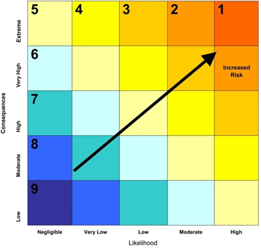
Source: Rainy River EIS, AMEC
| Malfunction or Accident | Issue of Concern | Likelihood | Consequence | Risk (See Fig. 8-1) |
|---|---|---|---|---|
| Structural Failures | ||||
| Open pit slope failure | Damage to habitat; limited flooding of open pit | Low | Moderate | 6 |
| East mine rock stockpile slope failure | Damage to terrestrial habitat, aquatic life | Very low | High | 6 |
| Overburden stockpile slope failure | Damage to terrestrial habitat, aquatic life | Very low | Moderate | 7 |
| Tailings dam failure | Damage to terrestrial habitat, aquatic life | Negligible | Extreme | 5 |
| Pond dam failure | Damage to aquatic life | Negligible | Moderate | 7 |
| Creek diversion failure | Damage to aquatic and terrestrial habitat, and aquatic life | Negligible | Moderate to high | 7 |
| Accidents | ||||
| Tailings pipeline failure | Damage to habitat and aquatic life | Very Low | High | 6 |
| Water pipeline failure | Damage to aquatic life | Very Low | Low | 7 |
| Fuel release during truck transport | Damage to aquatic life and downstream human environment | Very Low | High | 6 |
| Fuel release from storage facilities and dispensing area | Damage to habitat | Low | Low | 7 |
| Transportation accident – hazardous materials (excluding fuel) | Damage to habitat, aquatic life and downstream human environment | Very Low | High | 6 |
| Transportation accident – non-hazardous materials | Local terrestrial environment impact | Low | Low | 7 |
| Chemical spills from pressurized vessels | Damage to property and human environment | Negligible | Very high | 6 |
| Other Malfunctions | ||||
| Unexpected water quality concerns | Damage to aquatic life | Very Low | High | 6 |
8.1.1 Effects predicted and mitigation measures by proponent
Structural failures
The environmental impact statement (EIS) identifies six potential structural failures, and in each case the proponent has either identified design safeguards or proposed actions to mitigate effects.
Open pit slope failure
The EIS indicates that open pit slope failure of 40 metre could cause a rerouting of the Pinewood River into the open pit, which could reduce downstream flow. The likelihood, however, is low because the flood control berm is 60 metre from the open pit slope. Potential effects of reduced water flow into the Pinewood River are discussed in section 6.2.
Proponent's design safeguards:
- Maintain appropriate ramp width and grade;
- Monitor pit wall for geotechnical stability;
- Maintain appropriate overburden slope angles;
- Monitor overburden slope movement;
- Revegetate exposed overburden as soon as practical;
- Reinforce, in case of localized erosion, overburden slopes with mine rock or progressive re-vegetation; and
- Construct a flood protection berm 60 m from the maximum open pit extent.
East mine rock stockpile slope failure
The EIS indicates that the east mine rock stockpile contains encapsulated potentially acid generating waste rock. In the event of a slope failure, there would be a release of runoff affected by acid rock drainage and metal leaching and loss of habitat. If the rock failure were to infill a perimeter ditch, acid rock drainage and metal leaching runoff could potentially overflow or otherwise exit the ditch and could drain towards the Clark Creek Diversion or the Pinewood River. Effluent could contain pH, total suspended solids and ammonia in excess of applicable discharge criteria and would be toxic to aquatic life. Potential effects on water quality and fish and fish habitat are discussed in sections 6.3 and 7.1, respectively.
Proponent's proposed actions in case of failure:
- Re-contour, in the event of a stockpile slope failure, the slope in place;
- Excavate any material which migrated as far as the drainage ditch area and return it to the stockpile. If required, repair the drainage ditches; and
- Report and monitor spill, if potentially acid generating rock or stockpile runoff migrated beyond the collection ditches.
Overburden stockpile slope failure
The EIS indicates that the overburden and west mine rock stockpile, containing non-potentially acid generating (non-potentially acid generating) rock, could partially sink to the ground raising the toe of the stockpile (where the slope meets the ground) adjacent to the West Creek Diversion Channel or Pinewood River.
A worst case failure is expected by the proponent to extend 10 m from the stockpile toe and potentially release suspended solids into the West Creek Diversion Channel or Pinewood River. Suspended solids could interfere with aquatic life by damaging fish gills, interfering with feeding, or smothering eggs by preventing oxygen exchange. Potential effects on fish and fish habitat are discussed in section 7.1.
Proponent's design safeguards:
- Construct external slopes with relatively dry clays or clays mixed with rock for stability; and
- Capture stockpile runoff in perimeter runoff collection ditches and direct the water to sedimentation ponds.
Proponent's proposed actions in case of failure:
- Excavate any material that migrates as far as the perimeter ditch and return it to the stockpile. If required, repair the drainage ditches; and
- Deploy silt fencing, if the slope failure caused effluent in the perimeter ditching to spill, downstream of the spill to prevent sediment laden waters from entering a watercourse.
Tailings management area dam failure
The EIS indicates that failure of the tailings management area dam could result in some contained spilling of tailings solids and ponded effluent into the Pinewood River. The proponent anticipates that a tailings management area dam failure is unlikely to occur as the ponded effluent would be stored in the north portion of the tailings management area. Some of the tailings solids would be deposited in the constructed wetland as the tailings slurry flows down the West Creek into Pinewood River. The tailings slurry would destroy fish habitat and vegetation in its path. The tailings slurry would degrade surface water and groundwater quality. Potential effects on water quality and fish and fish habitat are discussed in sections 6.3 and 7.1, respectively.
Proponent's design safeguards:
- Construct tailings management area dams to withstand the probable maximum flood and maximum possible earthquake in accordance with the Ontario Lakes and Rivers Improvement Act;
- Inspect tailings management area dams visually on a daily basis;
- Install geotechnical monitoring equipment to monitor any movement of dams; and
- Conduct geotechnical inspections at regular intervals.
Proponent's proposed actions in case of failure:
- Pump, in the event of a breach or failure, the tailings management area pond to the water management pond, to reduce the amount of released effluent during the emergency repair;
- Contain the spill to the extent possible using temporary earthen or snow dams, silt fences, turbidity curtains, sandbags and other available equipment;
- Work closely with local residents and authorities and address the needs of downstream residents; and
- Develop spill management measures as part of the contingency and response plan in consultation with appropriate government agencies in the event of dam failure to:
- Contain spilled tailings based on their acid rock drainage characteristics;
- Excavate spilled tailings and haul them back to the repaired tailings management area or, alternatively, engineer a cover over the deposited material; and
- Restore and revegetate all areas where tailings are removed, to the extent practical.
Pond dam failure
The EIS indicates that the proponent will create several ponds containing mine-affected water to support onsite water management. The mine rock, water management, water discharge, and seepage collection ponds may contain elevated levels of minerals and metals. If a pond dam breaches, the effluent would flow into the Pinewood River causing toxic substances to destroy fish and fish habitat. Other ponds such as the West Creek, Clark Creek, stockpile, and Teeple ponds will contain fresh water. If these pond dams breach, the fresh water would flow into Pinewood River. Depending on the quantity of water and speed of release, the environment in the flow path would be damaged with scour and erosion. A major pond failure could damage vegetation, result in a temporary loss of aquatic habitat and cause physical harm to any wildlife caught in the flow path, either by drowning or debris collision. Potential effects on water quantity, water quality, and fish and fish habitat are discussed in sections 6.2, 6.3 and 7.1, respectively.
The proponent noted that, should a release of deleterious waters occur, remediation would not be possible unless a downstream pond is present to catch released water. Although water from the mine rock pond and water management pond would be toxic to aquatic life, it would be diluted to non-toxic levels when mixed with Pinewood River under emergency conditions. The proponent does not expect long-term environmental impacts from a pond dam failure.
Proponent's design safeguards:
- Store environmental design flood10 runoff above the maximum operating water level in ponds containing mine-affected water;
- Construct spillways to ensure safe discharge to the environment should an event ever exceed the environmental design flood;
- Construct dam slopes and crest widths for stability in relation to the mine rock pond, water management pond, as well as ponds not affected by mine water;
- Design the retention period of sedimentation ponds to meet the Metal Mining Effluent Regulations discharge requirements for total suspended solids;
- Size the diversions to convey the probable maximum flood without overtopping; and
- Inspect pond dams on a regular interval by site employees; and periodically on an interval that meets, at a minimum, regulatory requirements by a qualified geotechnical engineer.
- Proponent's proposed actions in case of failure:
- Deploy, in the event of a failure or imminent failure of a pond dam, silt fences, turbidity curtains, sandbags and other erosion and sediment control measures to prevent the entry of sediments into a downstream water body; and
- Keep appropriate spill control equipment at the project site.
Creek diversion failure
The EIS indicates that the complete failure of either West Creek or Clark Creek diversion channels would be related to erosion, sedimentation and loss of aquatic habitat due to a major storm event. The excess flows could wash soil out from vegetation causing erosion and could degrade terrestrial habitat. Where the beached runoff re-enters surface waters, extra sediments would be released to the water column thus affecting aquatic life, including fish and fish habitat. Potential effects on water quantity, water quality, and fish and fish habitat are discussed in sections 6.2, 6.3 and 7.1, respectively.
Proponent's design safeguards:
- Size all diversions to convey the probable maximum flood without overtopping; and
- Operate the initial portion of the West Creek Diversion Channel as the emergency spillway for the West Creek pond.
Proponent's proposed actions in case of failure:
- Undertake emergency repair, in the event of a failure or imminent failure of a diversion, as soon as possible;
- Address the needs of downstream residents by working closely with local residents and authorities; and
- Install, if possible, erosion and sediment control measures (such as silt fences, turbidity curtains, sandbags, erosion mats and other equivalent measures) downhill of the failure.
The proponent has committed to implement additional mitigation measures as identified in Appendix A: Part 2.
Accidents
The EIS indicates seven potential accidents or failures, and in each case the proponent has either identified design safeguards or proposed actions to mitigate effects.
Tailings pipeline failure
The EIS indicates that a tailings pipeline failure would result in a tailings slurry spill. The effect of the spill would depend on the time of the year, the location of the spill, and the volume spilled. If the spill occurred when the ground was frozen, spilled material would be readily cleaned up and no environmental impact would be expected. During the remainder of the year, the spill would cover surrounding terrestrial or aquatic habitat. The pipeline only crosses one watercourse (West Creek). The solids, essentially sand, contained in the slurry would be retained in close proximity to the pipeline rupture, regardless of season. Liquid from the spill would flow by gravity toward the West Creek and West Creek Diversion Channel, the constructed wetland, and potentially the Pinewood River. Potential effects on water quality and fish and fish habitat are discussed in sections 6.3 and 7.1, respectively.
Proponent's design safeguards:
- Install pressure sensors at four locations along the pipeline route and flow transmitters at the onsite metal mill and at the tailings management area dam, as the primary operational safeguards;
- Install a vacuum relief valve at the tailings management area dam to ensure reverse flow is not possible. The proponent responded that the pump will automatically shut off in the event of a pressure loss resulting from a failure;
- Inspect the tailings pipeline twice per 12-hour shift;
- Undertake incidental observation to identify leaks occurring below the pressure loss detection point; and
- Institute a ditch andcapture basin system to act as secondary containment in case of a leak; and
- Install secondary containment at the tailing pipeline crossing of the West Creek.
Proponent's proposed actions in case of accident:
- Use heavy equipment and spill containment materials in order to contain or limit the discharge of tailings and effluent to the environment;
- Implement spill management measures as part of the contingency and response plan, depending on the amount of tailings spilled and whether tailings enter West Creek, in consultation with appropriate regulatory agencies; and
- Excavate spilled tailings and load on a haul or vacuum truck, and transport to the tailings management area.
Water pipeline failure
The EIS indicates that a water pipeline failure would release water causing erosion downslope due to the force and volume of water being released. This could result in a short-term sediment plume to be released to water, resulting in potential impacts to aquatic life by damaging fish gills, interfering with feeding, or smothering eggs by preventing oxygen exchange. Potential effects on fish and fish habitat are discussed in section 7.1.
Proponent's design safeguards:
- Inspect and employ regular incidental observation activities to identify visible leaks or failure of the pipeline.
Proponent's proposed actions in case of accident:
- Shutdown pumps, upon discovery of a leak or failure, and repair the pipeline; and
- Employ, if possible, erosion and sediment control measures, such as matting, straw bales or silt fencing to prevent overland runoff containing sediments from directly entering a watercourse.
Fuel release during truck transport
The EIS indicates that fuel spills from tanker trucks could occur due to collisions, accidents related to poor weather conditions, or other mishaps. A diesel spill from a truck travelling to site could affect the soil (or snow in winter) in the vicinity of the spill, and could potentially enter a water body and impact aquatic life, if the accident occurred on or near a water crossing. Diesel fuel and gasoline is toxic to aquatic life when spilled in fresh water and impacts to aquatic life could include serious physiological damage or mortality. Potential effects on water quality and fish and fish habitat are discussed in sections 6.3 and 7.1, respectively.
Proponent's design safeguards:
- Develop and implement spill management measures as part of the contingency and response plan; and
- Manage trucking and supply contracts, by incorporating, as reasonable, features to minimize the potential for environmental impacts on the trucking route, including:
- strict adherence to speed limits, national trucking hour limits and other applicable requirements;
- drivers must meet all applicable regulatory training requirements as per the Transportation of Dangerous Goods Act, be trained in spill response procedures and carry Material Safety Data Sheets for hauled material regulated under the federal Hazardous Products Act; and
- all material transport vehicles must maintain basic emergency response equipment in order to stop or slow spills, using available equipment.
Proponent's proposed actions in case of accident:
- Employ spill counter measures, including use of absorbent materials, establishment of a collection trench, and setting of containment booms on water;
- Contain fuel with booms, berms or other means, and, possibly also pump, skim or mop fuel with absorbent matting, and dispose in an approved facility designed to manage such wastes;
- Contain and remediate, where possible, spills that may directly enter a fast moving watercourse; and
- Conduct a review, after any major spill, to ensure that the required design changes, procedures and appropriate monitoring measures are in place to ensure that similar incidents are not repeated.
Fuel release from storage facilities and dispensing areas
The EIS indicates that environmental effects of a fuel release from a storage facility may be less than a release from truck transport, as fuel storage tanks are in a fixed location. A fuel spill or a major spill during a rainfall event would affect the immediate terrestrial environment. The fuel storage facility will be located near the crusher where drainage will flow to the mine rock pond or stockpile pond. In either case, the spill and associated runoff would be contained and treated prior to being discharged from the pond.
Proponent's design safeguards:
- Include design and construction features to minimize the potential for environmental impacts as follows: containment berms, collision protection poles, placement of the storage areas away from watercourses and the use of leak detection requirements;
- Incorporate operational procedures to minimize the potential of accidents or malfunctions into the contingency and response plan;
- Keep and maintain a large spill kit, including absorbent material, at the fuel storage facility; and
- Inspect, regularly, all fuel storage locations and volumes for leakage and other operational problems.
Proponent's proposed actions in case of accident:
- Implement spill management measures as part of the contingency and response plan if fuel escapes the secondary containment berms;
- Seal, when the area is secured, the leak or failure, if possible;
- Contain the spill by using absorbent materials or by constructing a downstream berm;
- Collect and haul spilled fuel offsite for disposal;
- Send used absorbent material offsite for disposal at a licensed facility;
- Report on and notify spills in accordance with the Ministry of the Environment and Climate Change requirements;
- Cease all pumping from the pond if a spill migrates to the mine rock pond or stockpile pond, contain the spill with a boom, and remove with a skimmer;
- Test soils in the vicinity of the spill for hydrocarbons and delineate the affected soils; and
- Treat impacted soil onsite in a bioremediation area or haul offsite for treatment and disposal.
Transportation accidents
The EIS indicates that transport vehicle accidents on route to the project site could result in a spill of the materials, including fuel or hazardous materials. The consequences of a spill would depend on the type and quantity of material spilled, and the location and timing of the spill. Spills involving solid briquettes of cyanide into the aquatic environment are of particular concern, as impacts to aquatic life would occur, including serious physiological damage and mortality. Potential effects on water quality, and fish and fish habitat are discussed in sections 6.3 and 7.1, respectively.
Proponent's design safeguards:
- Ship all materials of consequence in sealed containers, such as tanker trucks, containers, shipment cubes (1000 litres), sealed bulk bags, 205 litres sealed drums and smaller containers on pallets;
- Ensure, all shipments comply with regulatory requirements, including the federal Transportation of Dangerous Goods Act and associated regulations; and
- Incorporate operational procedures on minimizing the potential for environmental impacts into trucking contracts and the contingency and response plan including: strict adherence to speed limits; restricting oversized loads to daylight travel where possible; avoiding material transport when visibility is low; and regular vehicle maintenance.
Proponent's proposed actions in case of accident:
- Remove potential ignition sources in the event of a spill of flammable or combustible materials, if safely possible; also slowdown or stop the spill;
- Notify the Ministry of the Environment and Climate Change's Spills Action Centre (per the requirements of the Ontario Environmental Protection Act), the Township of Chapple, Emo Fire Department, and, if required, the Technical Standards and Safety Authority (for fuel fires and explosions);
- Conduct an assessment and determine the best means to prevent immediate environmental impacts;
- Implement spill management measures as part of the contingency and response plan, such as the use of absorbent materials, establishment of a collection trench downslope, and setting of containment booms on water if effective for the spilled material;
- Ensure clean-up and remediation reduces long-term environmental impacts to the extent possible; and
- Conduct a review and report, after the incident, to ensure that any required design changes and procedures are in place to prevent a similar accident.
Chemical spill within contained facilities and chemical spills from pressurized vessels
The EIS indicates that there is no reasonable potential for chemical spills within contained facilities to be released directly to the environment or to have an environmental effect. The EIS indicates that pressurized vessel failure has the potential to affect worker health, cause damage to project infrastructure or facilities; and cause localized temporary air quality concerns due to a release of sulphur dioxide or oxygen. Impacts would be limited to the immediate atmospheric environment as a result of the rapid dissipation of the material as it expands out from the vessel itself and the volume of gas contained.
Proponent's design safeguards:
- Store all chemicals which pose a potential risk to the environment within contained areas, with sealed floors and sumps or drains reporting to facilities which will provide for retrieval of the spilled materials;
- Ensure all chemicals used at the site have a Material Safety Data Sheet, in order to comply with industry best practices and with the Workplace Hazardous Materials Information System Ontario Regulation 860 and Occupational Health and Safety Act for the safe use of these materials;
- Include a spill pad for the liquid oxygen storage area; and
- Manage spills from the sulphur dioxide area in a containment area.
The proponent has committed to implement additional mitigation measures as identified in Appendix A: Part 2.
Other malfunctions
Unexpected water quality concerns related to acid rock drainage
The EIS indicates that effluent released from the water management pond could impact water quality (i.e., pH levels, elevated dissolved minerals, ammonia or cyanide) and would be toxic to aquatic life, if the treatment of mine rock and tailings materials is insufficient. Potential effects on water quality and fish and fish habitat are discussed in sections 6.3 and 7.1, respectively.
Proponent's design safeguards:
- Segregate rock for use as construction materials according to a site-specific protocol, which is expected to include:
- preliminary visual identification of construction materials from the open pit which undergo geochemical testing;
- supplementary refinement based on a geochemical block model, to identify the location of blocks of material which are eligible for construction usage;
- periodical geochemical testing of the blocks to assess appropriate location for storage or for construction use and confirmation of model results; and
- visual inspection of material during placement and after construction for signs of acid rock drainage.
- Extract any material used in construction that is identified as acid generating, through visual identification and subsequent sampling. Transport material to the east mine rock stockpile for storage and encapsulate. Alternatively, take other appropriate measures to leave the material in place.
The proponent has committed to implement additional mitigation measures as identified in Appendix A: Part 2.
8.1.2 Residual effects by proponent
Residual effects from structural failures of the east mine rock stockpile slope, overburden stockpile slope, tailings management area dam, pond dam, and creek diversion were predicted to have the potential to destroy or disrupt fish and fish habitat through the release of acid drainage, metals and suspended solids into the Pinewood River watershed. Residual effects from accidents such as tailings pipeline failure, water pipeline failure, fuel release during truck transport and transportation accidents were predicted to also have the potential to impact aquatic life by damaging fish gills, and interfering with feeding or smothering eggs by preventing oxygen exchange. Chemical spills from pressurized vessels were predicted to have a potential impact on the atmospheric environment as a result of rapid dissipation of released material. Residual effects on unexpected water quality concerns related to acid rock drainage were predicted to have a potential impact to fish and fish habitat through degradation of water quality.
The residual effects on structural failures, accidents and other malfunctions are unlikely to occur taking into account the implementation of mitigation measures, proposed project design, operational safeguards and contingency procedures.
8.1.3 Comments received
Government authorities
Federal authorities expressed concerns over the potential effects of a tailings management area dam failure on channel morphology, substrate types and downstream fish and fish habitat. The Ministry of Natural Resources and Forestry also expressed concerns relating to a tailings management area dam failure. The proponent provided an additional dam breach and watercourse erosion assessment. This assessment included the worst case scenario of a full dam breach releasing a large volume of tailings into the Pinewood River at a time of low to zero flow in the summer. The assessment indicates that the release of tailings would likely affect a six kilometre reach of the Pinewood River, immediately downstream of the tailings management area. The remaining 30 km reach of the Pinewood River to the confluence of Rainy River would have low susceptibility to erosion.
Environment Canada expressed concern about the potential for uncollected seepage from project facilities and requested more information on the management of effluent from the sediment ponds. The proponent will have a contingency and response plan in place to address the potential for uncollected seepage from project facilities, including the sediment ponds. In response to Environment Canada's concern the proponent will install secondary containment for tailings and contact water pipelines at the crossing of the West Creek.
Environment Canada expressed concerns about the potential for poorly screened materials through visual inspection of potentially acid generating or non-potentially acid generating rock to affect water quality and fish in the Pinewood River watershed. The proponent will use visual evaluation and geochemical data to characterize the rock material as potentially acid generating or non-potentially acid generating. The local potentially acid generating till is quite distinctive from the surrounding materials and is readily identified in the field. Environment Canada was satisfied.
Aboriginal communities
Aboriginal communities expressed concerns about spills and suggested the establishment and dissemination of a protocol in advance of a spill or emergency. The proponent indicated that there is no possible event where downstream waters would be contaminated by a spill, such that alternative drinking water would be required by Aboriginal communities. The additional dam breach and watercourse erosion assessment includes worst-case scenarios for a tailings dam failure. The proponent will develop a contingency and response plan that includes a number of aspects relating to accidents and malfunctions.
Concerns were expressed about spills and accidents impacting on Aboriginal fisheries and wildlife in the Pinewood River watershed. The proponent will provide timely notification and consultation on spills and accidents if any, and on the details of any investigation and response to these events (Appendix A). The proponent will also provide assistance and opportunities for ongoing consultation on environmental approvals, the mine closure plan, a contingency and response plan, and the follow-up monitoring plan.
Aboriginal communities expressed concerns about the potential for acid rock drainage and metal leaching to impact drinking water and aquatic life. The proponent would ensure that surface water going into the Pinewood River from the mine would meet site-specific criteria for the protection of aquatic life.
Concerns were raised about the potential for acid rock drainage from tailings and mine rock to enter the Pinewood River. The proponent will use in-plant sulphur dioxide and air treatment on the mill effluent followed by removal of additional metals through effluent aging in the tailings management area and water management ponds. The proponent also indicated that the constructed wetland is expected to absorb residual metals over the period of the mine life, such that there will be an expected accumulation of residual metals within the wetland sediments. The area of the wetlands is comparatively small and the potential exposure to fish and wildlife is limited.
Public
Members of the public did not express concerns about structural failures or accidents. There was a concern related to unexpected water quality impacts from acid rock drainage. The public expressed concern about the potential for groundwater contamination in the event of seepage or leakage from the tailings management area. The seepage from the tailings management area is expected to be small given the low permeability of the bedrock and clays in the area. The proponent will monitor groundwater quality around the tailings management area, including pre-mining samples collected from well owners who request sampling.
8.1.4 Agency analysis and conclusion
The Agency is satisfied with the characterization of the risk of structural failures, accidents, and other malfunctions in the EIS. The proponent has responded to government authorities, Aboriginal and public comments including by committing to provide timely notification to Aboriginal communities on spills and accidents, if any. The structural failures, accidents and other malfunctions that could result in significant residual effects have a very low to negligible likelihood of occurrence. The proponent will continue to engage the Aboriginal communities in the development of a contingency and response plan related to accidents and malfunctions. The Agency considers that the residual effects on structural failures, accidents and other malfunctions are unlikely to occur, taking into account the implementation of mitigation measures, proposed project design, operational safeguards and contingency procedures.
The Agency concludes that the Project is not likely to result in significant adverse environmental effects as a result of structural failures, accidents, and other malfunctions, taking into account the likelihood and consequence of occurrence, the proposed project design, operations safeguards, contingency procedures and implementation of the mitigation measures.
8.2 Effects of the Environment on the Project
Environmental factors such as water supply availability, increased mine water volumes, and natural hazards could potentially affect the Project, resulting in service interruption, damage to infrastructure, or adverse environmental effects.
8.2.1 Effects predicted by proponent
Water Supply Availability
Local runoff conditions vary, resulting in a probability of too little, or too much water at the project site in any given year. Low flows in the Pinewood River would reduce assimilative capacity of the river to accept mine effluent in a sufficient mixing ratio to meet discharge limits for the protection of aquatic life.
Increased Mine Water Volumes
The tailings management area provides for seasonal effluent discharge to the environment. Increased mine water from precipitation, surface runoff and groundwater inflow would potentially increase the rate or period of seasonal excess effluent release to the environment. Mine water does not pose a safety hazard and will not cause additional malfunctions or environmental effects.
Natural Hazards
Potential natural hazards in the geographic location of the Project include earthquakes (tailings management area structural failure), extreme floods (tailings management area structural failure and open pit flooding), natural fires, and ice jams. A tailings management area structural failure resulting from an earthquake would have the potential to release contaminants from the tailings management area directly into the environment. However, the project site is located in a low risk seismic zone. Extreme floods would have the potential to cause structural failure of the tailings management area, and to flood site facilities. This would cause some contained tailings material and all of the ponded effluent to spill into the Pinewood River. Forest fires are part of the natural regeneration cycle at the project site. Project components most vulnerable to fires include the onsite metal mill and the transmission line. Natural fires would not result in any additional environmental effects. Ice jams on the Pinewood River could affect the integrity and function of the pit protection berm.
8.2.2 Mitigation measures by the proponent
The Agency agrees with the following key mitigation measures proposed by the proponent to mitigate any change to the Project that may be caused by the environment:
- Design the water management plan (Figure 11) to provide a large reservoir capacitywithin the tailings management area, and the east mine rock and water discharge ponds that will accommodate year-to-year variations in runoff (water supply) conditions.
- Design the tailings management area and open pit to withstand the probable maximum flood, including by constructing a pit protection berm between the Pinewood River and the open pit, and designing the tailings management area according to the Ontario Lakes and Rivers Improvement Act.
- Ensure that an electrical distribution system at the project site is availableby repairing damaged transmission lines, maintaining emergency diesel generators; and locating the onsite metal mill and transmission line close to open fields, wetlands, patchy forest and exposed rock terrain, to limit the risk of damage from fire.
- Develop measures to manage ice jams as part of the contingency and response plan to ensure that ice jams will not cause the Pinewood River to overflow the pit protection berm.
Figure 11: Water Management Plan
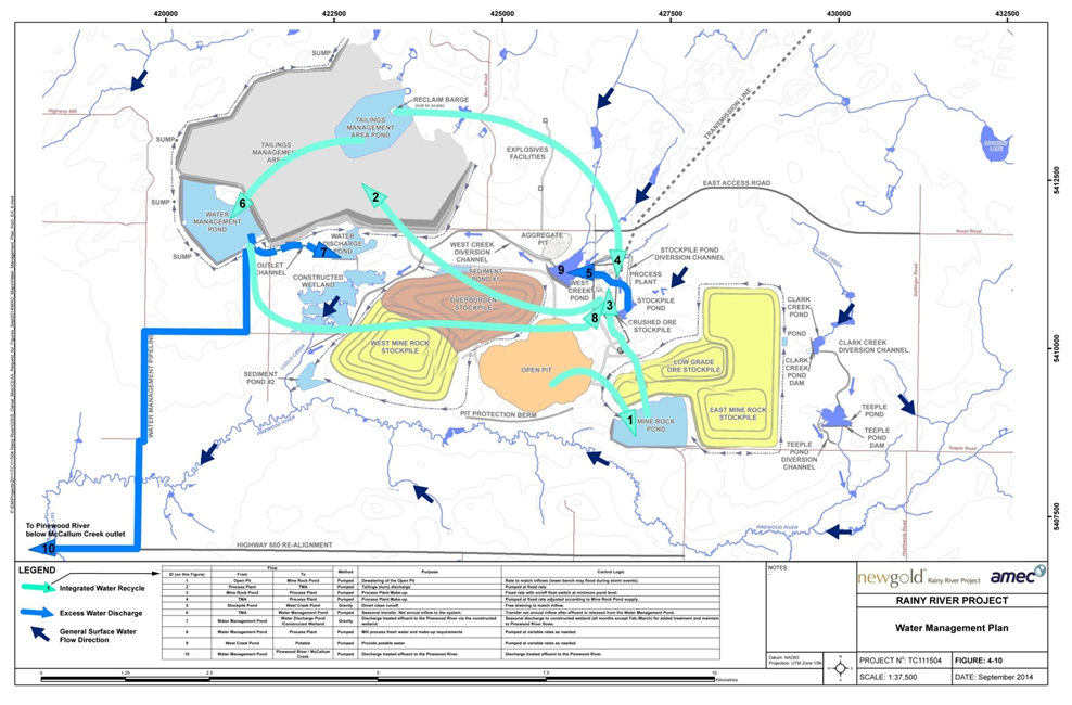
Source: Rainy River EIS, AMEC
8.2.3 Residual effects by proponent
The residual effects on water supply availability, increased mine water volumes and natural hazards were predicted not to cause additional malfunctions or environmental effects with the implementation of mitigation measures. In addition, the increased mine water volumes were predicted not to pose a safety hazard. A further assessment of the impacts to water quantity is discussed in section 6.2.
8.2.4 Comments received
Government authorities
Federal authorities raised concerns about the efficacy of proposed design safeguards to mitigate for the effects of potential water level fluctuations in covered and uncovered areas of the tailings management area.
Federal and provincial authorities also raised concerns about impacts of insufficient water supply in the Pinewood River on fish and fish habitat. The proponent proposed to take water in Pinewood River for a maximum of two years during mine construction.
Aboriginal communities
Aboriginal communities expressed concerns about the effect of ice jams on the outflow infrastructure of the mine, mixing of effluent, and water quality sampling. Ice jams are expected to occur in the Pinewood River from time to time.
Public
During the comment period of the EIS Guidelines, members of the public raised concerns about the potential for surface and groundwater contamination, in the event that heavy flooding or rainfall events cause the tailings management area to overflow.
8.2.5 Agency analysis and conclusion
The proponent has adequately designed the Project to account for water supply availability, increased mine water volumes, and natural hazards. Mitigation measures to reduce the potential effects include designing the tailings management area to contain the environmental design flood, and spillways to pass the probable maximum flood.
The proponent has responded to government authorities, Aboriginal and public comments by committing to maintaining the top of the tailings surface below the elevation of the spillway by three metres. The Agency expects that the residual effects of the environment on the Project will not cause additional malfunctions or environmental effects with the implementation of mitigation measures. In addition, the Agency agrees with the proponent that the increased mine water volumes are not predicted to pose a safety hazard.
8.3 Cumulative Environmental
A cumulative environmental effects assessment determines if environmental effects are likely to result from the designated project in combination with other physical activities that have been or will be carried out. The proponent's assessment of cumulative effects took into consideration the Agency's Operational Policy Statement11.
8.3.1 Approach and scoping
The cumulative environmental effects assessment considered all valued components (VCs) identified (Table 1) during the assessment of environmental effects of the Project. It incorporated the temporal and spatial boundaries of the VCs in the project-specific environmental effects assessment. It was restricted to the analysis of cumulative effects on the existing environmental baseline conditions, related to identified projects and activities that will be carried out within the broader regional context, and possibly overlapping with the Project in terms of effects, time, and location. Projects and activities at the planning stage, for which a decision to proceed has not been made, were generally excluded.
The EIS considered past and current projects and activities in the evaluation of project-specific effects, relative to existing baseline conditions. These included forestry operations, transportation uses and potential disturbances to wildlife. No regional studies are available for consideration. The EIS identifies potentially foreseeable but undefined projects that could contribute to cumulative effects. The existing and reasonably foreseeable projects are listed in Table 10.
| Project/Activity | Distance from the Project | Project/Activity Status |
|---|---|---|
| Existing projects | ||
| Dave Rampel Solar Park | 1.5 km east of the hamlet of Pinewood, within the lower portion of the Pinewood River watershed. | Ontario's Renewable Energy Approval received in September 2013 |
| Forestry – Crossroute Forest Management Unit | Project site is located within the Ontario's Crossroute Forest Management Unit | No planned harvesting in the area overlapping with the Human Environment Local Study Area. |
| Ministry of Transportation rehabilitation projects | Human Environment Regional Study Area | To be constructed from 2013 to 2016 |
| Municipal works (e.g. building or local road upgrades) | Human Environment Regional Study Area | To be completed in 2015 |
| Exploration – Bayfield Ventures | At the project site | Exploration |
| Madsen Gold Project - Exploration | 266 km north | Exploration |
| Reasonably foreseeable projects | ||
| Hammond Reef Gold Project | 187 km east | Federal and provincial EA in preparation |
| Josephine Cone Mine | 145 km northeast | Federal and provincial EA in preparation |
| Phoenix Gold Project | 263 km north | Provincial approval received; tentative plans for production in 2014 |
| Cochenour Project | 258 km north | Production anticipated in the first half of 2015 |
Adapted from Rainy River EIS, AMEC
The EIS identifies possible positive cumulative effects on regional employment and business opportunities from some larger proposed mining projects listed in Table 10, and from the proposed Dave Rampel Solar Park.
8.3.2 Comments received
Government authorities
Health Canada expressed concern about air quality and noise cumulative effects from future quarries for the Project, and its potential to impact Aboriginal health. Explosives would also be required in the development of quarries, which could increase air emissions and noise levels near the project site. The proponent noted that locations identified for the proposed quarries, are all within the project site, and not close to any Aboriginal communities, which are all located well outside the Natural Environment Local Study Area and Natural Environment Regional Study Area. It also noted that approximately 3 700 000 m3 of aggregate is required, the equivalent of 30 days of mining during the operation phase. The proponent concluded that based on this comparison the potential effects on air quality from aggregate handling in the pits and quarries is minor, compared to the potential air quality effects during the operation phase. Health Canada was satisfied with the response.
Aboriginal communities
Aboriginal communities expressed concern about land and animals already impacted by forestry practices in the area, and requested information on the Crossroute Forestry Management Plan to inform the cumulative effects assessment. The proponent indicated that information on the Crossroute Forest Management Plan and forestry practices are described in the EIS.
Aboriginal communities expressed concern about existing health impacts on fish, and suggested that information from other mines be used to inform the cumulative effects assessment. The proponent contacted the Seven Generations School and the Ministry of Natural Resources and Forestry, but did not obtain any additional information to inform the assessment. The proponent clarified that deformities and lesions were not noted on fish captured within the Natural Environment Regional Study Area or Natural Environment Local Study Area. Fish diseases or parasites that were visually recognizable were limited to black spot (caused by larval trematodes) which do not pose a health risk.
Aboriginal communities expressed concern that the spatial boundary in the consideration of cumulative effects was unclear. The project effects on the natural environment were unlikely to extend beyond the Natural Environment Regional Study Area. Only future projects that have the potential to affect identified VCs within the Natural Environment Regional Study Area were considered in the assessment of cumulative effects; no such projects were identified by the proponent.
Big Grassy River First Nation expressed concern about existing impacts; impediment to accessing lands; the ability of members to harvest berries, wild rice and other culturally important plants; and the ability to practice a traditional way of life. The proponent is pursuing ongoing discussions of site-specific mitigation measures on key VCs, including but not limited to culture, water quality, and traditional land use. The proponent will work closely with Big Grassy River First Nation to address community impacts; an important aspect of this will be an agreement that is being negotiated with Big Grassy River First Nation that will outline certain benefits to the community as a result of the Project.
Public
Members of the public did not raise concerns about cumulative effects.
8.3.3 Agency analysis and conclusion
In considering the proponent's approach to cumulative effects assessment, the Agency sought additional information in relation to past effects from forestry, agriculture and fires on migratory birds and exclusion of Bayfield Ventures activities as a reasonably foreseeable project. The Project will put additional stress on migratory bird habitats, but the proponent will implement additional mitigation measures to limit effects. The Agency accepts the proponent's position that the Bayfield Ventures project is hypothetical as there is no defined project plan other than continued exploration drilling.
The baseline for existing projects, such as agriculture, forestry and transportation infrastructure, was considered in the EA. The reasonably foreseeable projects listed in Table 10 are located far enough from the project site that they are not expected to have a cumulative effect with the environmental effects of the Project within the Natural Environment Regional Study Area identified by the proponent.
The only planned project within the Natural Environment Regional Study Area is the Dave Rampel Solar Park. The EIS does not describe the potential environmental effects of this solar park, but notes that there will be no tree or forest clearing associated with the solar park proposal, since the entire lease area consists of active agricultural fields. Upon review of the Dave Rampel Solar Park Renewable Energy Application12, the Agency has confirmed the predicted effects of the solar park include noise disturbance, dust, spills, alteration of current land conditions, storm water runoff, and materials generated at or transported from the project location. These effects are predicted to extend 300 m from the solar park. No predicted or residual effects of the solar park appear to overlap with the effects of the Project.
The Agency considers that there are no cumulative effects of the planned projects identified by the proponent with the Project. The thirteen Ministry of Transportation rehabilitation projects within the Human Environment Regional Study Area are mainly bridge rehabilitation works where the environmental effects are localized and understood. The potential effects can be mitigated with the implementation of the Ministry of Transportation environmental standards and practices, developed to protect the environment during all stages of highway management including maintenance. Residual effects are not expected.
The Agency concludes that the Project is not likely to result in significant adverse cumulative effects taking into account the proponent's assessment of potential cumulative effects, Health Canada and Aboriginal comments, the proponent responses and the Agency's analysis.
9 Impacts on Potential or Established Aboriginal or Treaty Rights
9.1 Potential or Established Aboriginal or Treaty Rights in the Project Area
The Project is located in a region covered by a historic treaty (Treaty 3) and overlapping assertions of Aboriginal rights by Métis represented by the Métis Nation of Ontario. As a result, the proponent identified several potential or established Aboriginal and Treaty rights held by First Nations and Métis communities that could be potentially affected by the Project. These include rights to fishing, hunting, and plant harvesting.
Plant and animal species of particular importance to the exercise of potential or established Aboriginal or Treaty rights were identified through Traditional Knowledge and Traditional Land Use studies conducted by the proponent, Big Grassy River First Nation, and Métis Nation of Ontario Region 1. These resources include deer, furbearers, game birds, moose, wild rice and berries.
9.2 Potential Adverse Impacts of the Project on Potential or Established Aboriginal or Treaty Rights
The EIS indicates that the Project has potential environmental effects that may adversely impact potential or established Aboriginal or Treaty rights. Vegetation clearing for mine construction and replacement of native species with non-native species during decommissioning could adversely affect potential or established Aboriginal or Treaty rights, due to the loss and fragmentation of terrestrial wildlife habitat for hunting and the loss of traditional plants for food and medicinal purposes. In addition, changes to fish, fish habitat, and commercial fisheries could adversely affect potential or established Aboriginal or Treaty rights to fishing, due to loss of fishing opportunities and contamination of fish tissues.
Potential effects on Aboriginal peoples within the context of current use of lands and resources for traditional purposes, health and socio-economic conditions, physical or cultural heritage and effects on historical, archaeological, paleontological or architectural sites or structures are discussed in greater detail in sections 7.3, 7.4, and 7.5, respectively.
Appendix E provides a table summarizing key Aboriginal concerns.
9.3 Proposed Accommodation Measures
The proponent worked with Aboriginal communities and federal and provincial authorities in developing mitigation measures that also serve as accommodation measures, designed to minimize or avoid potential adverse impacts on potential or established Aboriginal or Treaty rights.
The EIS indicates that the proponent is working with the Ministry of Natural Resources and Forestry to secure private lands to be used as habitat compensation for the Eastern Whip-poor-will. Subject to Ministry of Natural Resources and Forestry support, there is an opportunity to provide access to these lands to Aboriginal communities for hunting and plant gathering. The proponent committed to working with community members from the Métis Nation of Ontario Region 1 and Big Grassy River First Nation to develop adaptive management techniques related to the mine closure plan, and the remediation of wildlife habitat after decommissioning. These measures are discussed in greater detail in section 7.3.
The EIS also notes that access to nearby private lands will be provided by the proponent for traditional plant harvesting activities and the proponent committed to using native plant species to revegetate the project site during reclamation, to offset direct losses of traditional plants harvested for food and medicinal purposes. Measures to compensate for losses of traditional plants will also serve to minimize, avoid or compensate for potential adverse impacts on potential or established Aboriginal and Treaty rights. These measures are discussed in greater detail in section 7.3.
The proponent is working with Fisheries and Oceans Canada and the Ministry of Natural Resources and Forestry on fish habitat offsetting and compensation plans, to offset the loss of fish habitat within the proposed mine footprint. These plans are discussed in greater detail in section 7.1.
The proponent stated that it has signed some agreements with Aboriginal communities, and is working to finalize others. These agreements are expected to address any potential residual adverse impacts to potential or established Aboriginal or Treaty rights that may remain after the implementation of proposed mitigation measures.
9.4 Issues to be Addressed During the Regulatory Approval Phase
The regulatory approval phase of the Project consists of authorizations, licenses, or approvals related to areas of federal jurisdiction (e.g., effects on fish and fish habitat). Substantive work for potential federal authorizations under the Fisheries Act, Explosives Act and the Metal Mining Effluent Regulations will be required should the EA decision conclude that the Project can proceed. In this situation, the federal Crown would consult Aboriginal communities, as appropriate, prior to making regulatory decisions. The decision to undertake additional Crown consultation will take into consideration the consultation record resulting from the EA.
9.5 Agency Conclusion Regarding Impacts to Aboriginal or Treaty Rights
Based on the analysis of environmental effects of the Project on Aboriginal peoples and the related mitigation measures outlined in sections 7.3, 7.4 and 7.5 and the potential impacts and accommodation measures provided in sections 9.2 and 9.3, the Agency is satisfied that the potential impacts of the Project on potential or established Aboriginal or Treaty rights have been adequately identified and appropriately accommodated.
The Agency has identified key mitigation measures that address environmental effects on Aboriginal peoples and would support accommodation of potential impacts on potential or established Aboriginal or Treaty rights for consideration by the Minister of the Environment in establishing conditions as part of the decision statement, should the Project ultimately be permitted to proceed.
10 Follow-Up Program
Under the Act, pursuant to paragraph 19(1)(e), every EA must consider the need for, and the requirements of, a follow-up program. The purpose of a follow-up program is to verify the accuracy of an EA and to determine the effectiveness of any measures taken to mitigate the adverse environmental effects of a project. Appendix A: Part 1 and Table 11 outline the key requirements for the proponent's follow-up program. The proponent has committed to implement additional follow-up monitoring measures as identified in Appendix I.
Monitoring results will be provided to the Agency and federal and provincial authorities annually during the construction, operation, decommissioning, and abandonment phases of the Project. Additional reporting mechanisms will be prescribed in provincial and federal environmental approvals.
| Factor/Effect | Report Elements |
|---|---|
| Fish and Fish Habitat Loss of fish habitat for Aboriginal, recreational and commercial fisheries in the Minor Creek Systems and Pinewood River Potential effects to fish and fish habitat caused by increases or decreases in flows Potential decrease in water quality from contaminants in effluent, seepage and site runoff |
The follow-up monitoring plan will include:
|
| Migratory Birds Disturbance to migratory birds Loss of migratory bird habitat |
The follow-up monitoring plan will include:
|
| Current use of lands and resources for traditional purposes by Aboriginal peoples Potential changes to fishing, hunting, and plant harvesting practices Health and socio-economic conditions of Aboriginal peoples Potential decreases in air quality Potential changes to Aboriginal health from contamination of country foods and potential changes to commercial fishing practices Physical or cultural heritage and effects on historical, archaeological, paleontological or architectural sites or structures of Aboriginal peoples Potential changes to cultural heritage resources |
The follow-up monitoring plan will include:
Any notable cultural heritage finds will be reported according to regulatory requirements at the time, with reporting as required when and if further information becomes available. |
10.1 Comments Received
Government authorities
Federal and provincial authorities have indicated that they will be identifying specific monitoring and reporting requirements as part of regulatory authorizations. They also requested that the follow-up monitoring plan be designed to confirm flow predictions in Pinewood River, and confirm maintenance of ecological flows and stability for fish life cycles in the Minor Creek Systems and the Modified Minor Creek Systems. The proponent will measure flows in the Pinewood River, and indicated that the stability of diversion channels and ponds will be monitored on an annual basis for habitat stability and habitat structural function until the completion of construction. The Ministry of Natural Resources and Forestry was concerned by the lack of a follow-up monitoring plan for rare plants. Fisheries and Oceans Canada requested a description of monitoring in relation to the fish habitat offsetting plan. The proponent will consult with Fisheries and Oceans Canada on the development of the follow-up monitoring plan.
Natural Resources Canada reviewed the information related to impacts to groundwater quantity, and is of the view that the proponent has provided sufficient information for the purpose of the EA. Natural Resources Canada agrees with the proponent's model conclusions, mitigation measures and water management plan. Natural Resources Canada notes that the proponent will update its groundwater modelling and implement monitoring as part of the water management plan.
Aboriginal communities
Aboriginal communities expressed concern about the risks of mercury pollution on human health and its potential effects on drinking water. They were also concerned about the potential health risks from consuming fish and wild game, including White-tailed Deer, if heavy metals accumulate in their tissues. The contamination of wildlife that will be consumed may cause Aboriginal communities to avoid these areas for hunting. They were also concerned about contamination of berries. The proponent responded that no appreciable change in mercury levels is expected in the Pinewood River, and mercury health risks associated with fish consumption are not expected to change. The proponent will work with local Aboriginal peoples to monitor metal concentrations in country foods, including fish muscle and liver tissue, White-tailed Deer liver tissue, and other wildlife tissues as appropriate. This analysis could be expanded to include testing for additional metals. The most effective path forward will be determined in collaboration with local Aboriginal hunters and Aboriginal communities.
Aboriginal communities expressed concern about impacts on water quality, and requested that they be involved in monitoring for water quality. The proponent committed to joint water quality monitoring and reporting with local Aboriginal communities, and to engage them in developing the water management plan prior to construction.
Aboriginal communities expressed concerns about the potential dewatering of wells in the vicinity of the zone of influence from the open pit. The proponent acknowledged that there will likely be changes to groundwater flow from mine development, but these changes will almost entirely be restricted to its privately-owned property. The proponent will establish a groundwater well (piezometer) network around the open pit area to monitor groundwater levels on a continuous basis using water level transducers, with transducer downloads to be completed twice per year, commencing at least six months prior to the start of pumping.The proponent will also request well owners to participate in well water quality monitoring.
Aboriginal communities raised general concerns regarding the effects of the Project on wildlife, habitat, and wildlife movement. They asked to be involved in the planning and execution of the proposed follow-up monitoring plan related to several components, including terrestrial landscapes and species at risk. The proponent will engage Aboriginal communities and provide opportunities for ongoing consultation on environmental approvals, the mine closure plan, contingency and response plan; engage Aboriginal communities in the implementation of monitoring; and monitor key terrestrial landscapes and species at risk during construction, operation, decommissioning, and abandonment, including post closure habitat development and utilization by wildlife.
Public
Public comments were not received in relation to the follow-up program.
10.2 Agency Analysis and Conclusion
The Agency and government authorities reviewed the proponent's follow-up monitoring plan. During the course of the EA, the proponent clarified the frequency of monitoring for certain elements of the plan as follows: air quality, sound, vibration, surface and groundwater, key terrestrial landscapes and species at risk will be monitored during the construction, operation, and decommissioning phases; archaeology and built heritage will be monitored only during the construction phase; and monitoring frequency for traditional land use will be defined following ongoing consultations with Aboriginal groups. The proponent committed to updating groundwater modelling and implementing monitoring in response to comments from government authorities and Aboriginal groups. The proponent also committed to implement a wildlife follow-up monitoring plan for Eastern Whip-poor-will, Common Nighthawk, Bobolink, and Barn Swallow populations in response to government authorities' comments. Furthermore, the proponent committed to providing assistance and opportunities for ongoing consultation to Aboriginal groups on environmental approvals, the mine closure plan, the contingency and response plan, and the follow-up monitoring plan on matters related to spills and accidents. The proponent confirmed that it would develop an addendum on matters related to engaging the Métis Nation of Ontario Region 1 and other Aboriginal communities on the follow-up monitoring plan. Specifically, the Agency notes that the follow-up program will be informed by additional decisions made during the regulatory phase, and will be enhanced by specific engagement of Aboriginal communities.
The Agency is satisfied with the follow-up program as proposed by the proponent with changes proposed during the course of the EA.
11 Conclusions and Recommendations of the Agency
The Agency took into account the environmental impact statement (EIS), the views of the public, government agencies, and Aboriginal groups in determining whether or not the Project is likely to cause significant adverse environmental effects and to establish the requirements of the follow-up monitoring plan to be implemented by the proponent. The Agency received comments from Aboriginal groups, members of the public, and federal and provincial authorities on a draft of this EA report. Appendix J contains a summary of comments received and Agency responses.
The environmental effects of the Project have been determined using assessment methods and analytical tools that reflect current best practices of environmental and socio-economic assessment practitioners, including the consideration of cumulative effects and potential structural failures, accidents and malfunctions.
The Agency concludes that the Rainy River Project is not likely to cause significant adverse environmental effects, taking into account the implementation of the key mitigation measures described in this environmental assessment (EA) report and will make this recommendation to the Minister of the Environment.
Appendix A Part 1 – Key Mitigation and Follow-up Measures Considered by the Agency in the EA Report
Note: The Proponent Commitment Reference numbers provided below correspond to the commitments made by the proponent in their document entitled, "New Gold Rainy River Project – Commitments Registry" dated August 2014. This Appendix is a subset of the proponent's list of commitments.
Part 1 of this appendix lists key mitigation measures and follow-up program requirements identified by the Agency for consideration by the Minister of the Environment in preparing conditions as part of the decision statement.
| Valued Component | Mitigation Measures | Proponent Commitment Reference No. |
|---|---|---|
| Effects identified under Section 5(1) of the Act | ||
| Fish and Fish Habitat |
|
20, 22, 24, 27, 29, 30, 33, 34, 36, 38, 42, 43 44, 45, 46, 47, 49, 51, 52, 53, 55, 56, 57, 58, 59, 60, 61, 62, 65, 66, 68, 70,72, 73, 74, 75, 81, 118 |
| Migratory Birds including those listed as federal species at risk |
|
85, 86, 95, 97, 98, 101, 102, 103, 104, 108, 110, 111, 112, 113, 197 |
| Current use of lands and resources for traditional purposes of Aboriginal groups |
|
95, 115, 116, 119, 122, 127, 129, 130, 131, 132, 194 |
| Health and socio-economic conditions of Aboriginal groups |
|
1, 2, 4, 8, 123, 144 |
| Physical or cultural heritage and effects on historical, archaeological, paleontological or architectural sites or structures of Aboriginal groups |
|
132, 167, 175, 195 |
| Effects identified under Section 5(2) of the Act | ||
| Amphibians and reptiles including those listed as federal species at risk |
|
93, |
| Furbearers | No specific mitigation measures have been identified by the Agency, but measures taken in relation to fish and fish habitat will benefit the fur bearing population. | 61 |
| Federal species at risk |
|
103 |
| Other measures | ||
| Accidents and malfunctions |
|
42, 43, 159, 182, 197 |
| Follow-Up Program | ||
| Fish and fish habitat | The follow-up monitoring plan will include:
|
24, 28, 32, 44, 47, 51, 52, 63, 64, 67, 69, 76, 77, 80, 81 |
| Migratory pirds including those listed as federal species at risk |
|
82, 85, 99, 105, 109, 110, 111, 112 |
| Aboriginal peoples Current use of lands and resources for traditional purposes by Aboriginal peoples Health and socio-economic conditions of Aboriginal peoples Physical or cultural heritage and effects on historical, archaeological, paleontological or architectural sites or structures of Aboriginal peoples |
|
4, 8, 117, 121, 164, 168, 174, 176 |
Part 2 – Proponent's Mitigation Measures and Commitments to Address Effects on Valued Components Identified by the Aboriginal Community and Federal Authorities
(Adapted from Rainy River EIS, AMEC)
The numbers in the first column correspond to the commitments made by the proponent in its document entitled, "New Gold Rainy River Project – Commitments Registry" dated August 2014. This Appendix is a subset of the proponent's list of commitments.
See footnote for abbreviations16.
| Proponent Commitment Reference No. | Commitment / Mitigation | Project Phase | Link to Federal or Provincial Authority or Aboriginal Community |
|---|---|---|---|
| Federal VC | Fish and Fish Habitat | ||
| Proponent VC | Geochemistry | ||
| 20, 24 |
|
E,C,O,D | Ministry of Northern Development and Mines , Ministry of the Environment and Climate Change, Environment Canada |
| 27 |
|
O,D | Ministry of Northern Development and Mines |
| 28 |
|
C,O | Ministry of Northern Development and Mines , Environment Canada |
| 29 |
|
C,O,D | Ministry of Northern Development and Mines |
| 30 |
|
C,O,D | Environment Canada, Ministry of the Environment and Climate Change |
| Federal VC | Fish and Fish Habitat | ||
| Proponent VC | Water Quantity | ||
| 32, 36 |
|
C,O | Ministry of the Environment and Climate Change, The Agency, Ministry of Natural Resources and Forestry |
| 33 |
|
C,O,D,P | Non-specific |
| 34 |
|
C,O,D,P | Ministry of Natural Resources and Forestry,Fisheries and Oceans Canada |
| 38 |
|
C,O | Ministry of the Environment and Climate Change |
| 43 |
|
C,O | Ministry of Natural Resources and Forestry |
|
C,O | ||
| Federal VC | Fish and Fish Habitat | ||
| Proponent VC | Water Quality | ||
| 22, 44 |
|
O | Ministry of the Environment and Climate Change, Environment Canada |
| 20 |
|
C, O, D | Environment Canada |
| 42 |
|
C,O,D, P | Non-specific |
| 42 |
|
C,O | |
| 45 |
|
C,O,D | Non-specific |
| 46 |
|
O,D | Ministry of Northern Development and Mines |
| 47 |
|
P, C,O | Ministry of Northern Development and Mines , Environment Canada |
| 49 |
|
E,O,D,P | Ministry of Northern Development and Mines , Environment Canada |
| 51 |
|
C,O | MOE, Ministry of Northern Development and Mines , Ministry of Transportation, Fisheries and Oceans Canada |
| 47, 51 |
|
||
| 52 |
|
C,O | Ministry of the Environment and Climate Change, Environment Canada |
| 53 |
|
C,O,D,P | Ministry of the Environment and Climate Change, Environment Canada |
| 55 |
|
E,C,O | Ministry of the Environment and Climate Change, Fisheries and Oceans Canada |
| Federal VC | Fish and Fish Habitat, Aboriginal Health and Socio-Economic Conditions, and Current Use of Lands and Resources for Traditional Purposes by Aboriginal Peoples | ||
| Proponent VC | Fish and Fish Habitat | ||
| 56 |
|
E,C | Ministry of the Environment and Climate Change |
| 57 |
|
C,O,D | Ministry of the Environment and Climate Change |
| 58 |
|
O,D | Ministry of the Environment and Climate Change |
| 59 |
|
O | Ministry of the Environment and Climate Change |
| 60 |
|
E,C | Ministry of Natural Resources and Forestry,Fisheries and Oceans Canada, Environment Canada |
| 61 |
|
E,C | Fisheries and Oceans Canada |
|
C,O | ||
| 62 |
|
C,O | MRN, Fisheries and Oceans Canada |
| 63 |
|
O,D | The Agency |
| 64 |
|
O,D | Ministry of the Environment and Climate Change, Ministry of Natural Resources and Forestry, the Agency |
| 65 |
|
E,C | Ministry of Natural Resources and Forestry, Fisheries and Oceans Canada |
| 66 |
|
C,O,D,P | Ministry of Natural Resources and Forestry, Fisheries and Oceans Canada |
| 67 |
|
C,O,D,P | Ministry of the Environment and Climate Change, Ministry of Northern Development and Mines , Environment Canada |
| 69 |
|
D | Ministry of Northern Development and Mines |
| 70 |
|
E | BGRFN, Ministry of the Environment and Climate Change, Environment Canada |
| 72 |
|
C | Ministry of Natural Resources and Forestry |
| 68, 73, 74, 75, 118 |
|
C,O,D,P | Aboriginal communities, the Agency, RRFN, Fisheries and Oceans Canada, Ministry of Northern Development and Mines |
| Federal VC | Fish and Fish Habitat, Recreation and Commercial Use | ||
| Proponent VC | Groundwater | ||
| 76, 77, 80 |
|
C,O,D,P | Ministry of the Environment and Climate Change, Ministry of Northern Development and Mines , Natural Resources Canada |
| 81 |
|
E,C,O,D,P | Ministry of the Environment and Climate Change, Ministry of Northern Development and Mines , Natural Resources Canada |
| Federal VC | Migratory Birds, Aboriginal Health and Socio-Economic Conditions, and Current Use of Lands and Resources for Traditional Purposes by Aboriginal Peoples | ||
| Proponent VC | Vegetation communities and rare plants | ||
| 82, 109 |
|
C,O,D,P | Ministry of Natural Resources and Forestry |
| 85 |
|
C,O,D | Non-specific, Ministry of the Environment and Climate Change |
| 86, 102, 203 |
|
E,C | Ministry of Natural Resources and Forestry,Ministry of Transportation, Environment Canada |
| Federal VC | Furbearers and Amphibians and Reptiles | ||
| Proponent VC | Ungulates, Furbearers, Bats, Amphibians | ||
| 91 |
|
C,O,D | Environment Canada, Ministry of Natural Resources and Forestry, The Agency |
| 92 |
|
E,C,O | Ministry of Natural Resources and Forestry |
| 94 |
|
C | Environment Canada, Ministry of Natural Resources and Forestry |
| Federal VC | Migratory Birds, Amphibians and Reptiles | ||
| Proponent VC | Wildlife | ||
| 95 |
|
E,C,O,D | Ministry of the Environment and Climate Change, Ministry of Natural Resources and Forestry, Ministry of Northern Development and Mines |
| 96, 97 |
|
C,O | |
| Federal VC | Migratory Birds, Aboriginal Health and Socio-Economic Conditions, and Current Use of Lands and Resources for Traditional Purposes by Aboriginal Peoples | ||
| Proponent VC | Birds and Habitat , species at risk: Species protected under the Ontario Endangered Species Act and species of special concern and provincially rare species | ||
| 98, 101, 103, 104, 108, 113 | The primary mitigation strategies for limiting adverse effects to birds and habitat:
|
E,C,O,D | Ministry of Natural Resources and Forestry,Environment Canada, Ministry of the Environment and Climate Change, Ministry of Northern Development and Mines |
| 99, 105, 110, 113 |
|
E,C,O,D | Ministry of Natural Resources and Forestry, Ministry of the Environment and Climate Change, Environment Canada |
| 111 |
|
E,C,O,D | Ministry of Natural Resources and Forestry, Ministry of the Environment and Climate Change, Ministry of Northern Development and Mines |
| 112 |
|
E,C,O,D | Non-specific, Ministry of the Environment and Climate Change, Ministry of Northern Development and Mines |
| Federal VC | Current use of lands and resources for traditional purposes by Aboriginal peoples, Physical or cultural heritage and effects on historical, archaeological, paleontological or architectural sites or structures of Aboriginal peoples | ||
| Proponent VC | Land and resource use related to both traditional and non-traditional use: Land use plans and policies; Mineral exploration; Forestry; Agriculture and adjacent residents; Hunting; Trapping; Fishing, and Other outdoor recreational uses. | ||
| 84, 86, 102, 115, 116, 117, 119, 121, 122, 123, 127, 131, 145 |
|
E,C,O,D,P | Aboriginal communities, the Agency, BGRFN, MNO |
| 132, 200, 168 |
|
E,C,O,D,P | BGRFN, The Agency |
| 138 |
|
E,C | BGRFN, Fisheries and Oceans Canada |
| Federal VC | Aboriginal groups – Health and socio-economic conditions | ||
| Proponent VC | Economic VSEC: Direct, indirect and induced employment opportunities Business opportunities, Income growth, Economic diversification, Human capital, and Government revenues. | ||
| 164 |
|
E,C,O,D | Aboriginal communities, Non-specific |
| 168 |
|
E,C,O | Non-specific, The Agency, BGRFN |
| 144 |
|
E,C,O,D | Aboriginal communities |
| 169 |
|
O,D | BGRFN, Ministry of Northern Development and Mines |
| 4, 8 |
|
C,O,D | |
| Federal VC | Current use of lands and resources for traditional purposes by Aboriginal peoples, Physical or cultural heritage and effects on historical, archaeological, paleontological or architectural sites or structures of Aboriginal peoples | ||
| Proponent VC | Social VSEC: Demographics and populations; Housing and accommodations; Public utilities; Community and social services; Highway traffic; Human health; and Cultural heritage resources. | ||
| 174 |
|
C | The Agency, Ministry of Tourism, Culture and Sport |
| 175, 176 |
|
C | Ministry of Natural Resources and Forestry |
| Proponent VC | General/Other | ||
| 186, 187, 188, 189, 191, 198, 200 |
|
E,C,O,D,P | Ministry of the Environment and Climate Change, Ministry of Natural Resources and Forestry,Ministry of Northern Development and Mines , Fisheries and Oceans Canada, Environment Canada, Non-specific, MNO |
Appendix B Summary of Residual Effects Assessment
| VC Affected | Residual Effect | Predicted Degree of Effect After Mitigation | Agency determination on significance of residual adverse environmental effect | Likelihood of Occurrence | |||||
|---|---|---|---|---|---|---|---|---|---|
| Magnitude | Extent | Duration | Frequency | Reversibility | Natural and Socio-economic environment context | ||||
| Fish and fish habitat |
|
Level I - low Effects considered to be minor (4 percent of the Natural Environment Regional Study Area) and will be offset in accordance with the Fisheries Act and Metal Mining Effluent Regulations. Effects are considered to be minor (<20 percent during average and high flow years; with flow enhancement during low flow periods in the Pinewood River). Treated runoff and seepage discharges will be in compliance with federal Metal Mining Effluent Regulations Schedule 4 limits and provincial Ministry of the Environment and Climate Change Environmental Compliance Approval. |
Level I - low Effects are considered to be confined to the project site. |
Level III - high Effects to the Minor Creek Systems and the Pinewood River are long-term and will extend beyond the life of the Project. |
Level III - high Effect to habitat is expected to be continuous through construction, operation, decommissioning and abandonment. Level II - medium Effects to flows are expected to have seasonal regularity; water taking will be continuous during the open water period during the second half of the construction period. |
Level III - high Effects to the Minor Creek Systems are not reversible at decommissioning, but the loss of fish habitat will be offset within the Pinewood River watershed. Level I – low Effects of water taking are readily reversible over time and upon cessation of water taking from the Pinewood River during construction. |
Level II - medium Adverse effects to the Minor Creek Systems would involve commonplace and widespread ecological communities, typical of small headwater creek systems in the area. The Pinewood River and the Minor Creek Systems are dominant local systems which support commonplace and widespread ecological communities. |
Not significant Rationale: Effects on fish and fish habitat are expected to diminish in duration and frequency and are expected to be reversible within the Pinewood River watershed upon the establishment of fish habitat offsetting measures. The measures will offset the loss of fish habitat and maintain the productivity of the fisheries in the Minor Creek Systems and the Pinewood River. Residual effects are expected to be minor and localized with the implementation of the proponent's water management plan and its commitment to develop minimum flow thresholds to protect aquatic habitats, in consultation with Ministry of the Environment and Climate Change and Fisheries and Oceans Canada. The proponent's commitment to implement monitoring programs for groundwater and surface water quantity will verify the predictions in the EA and determine the effectiveness of the mitigation measures. |
Effect will occur. |
| Migratory birds |
|
Level I - low Effects are considered to be minor (8percent of the Natural Environment Local Study Area). |
Level I – low Effects are considered to be confined to the project site. |
Level III – high Long-term effects will persist for the life of the Project. |
Level III - high Effect is expected to be continuous through construction, operation, and decommissioning of the mine. |
Level III - high Effects are reversible following decommissioning and abandonment. |
Level III - high Adverse effects will generally involve commonplace and widespread species, together with some species at risk species. |
Not significant Rationale: Residual effects on migratory birds are localized and the Project is unlikely to affect habitat availability or use of the migratory birds within the Natural Environment Local Study Area. Effects are expected to diminish in duration and frequency and are expected to be reversible upon the provision of compensatory habitat that will protect and provide habitat for Schedule 1 migratory birds pursuant to the Schedule 1 of the Species at Risk Act and assessed by COSEWIC and those that are not listed or designated. Potential local habitat for the migratory birds may be created from rehabilitation of the project site at decommissioning and abandonment. |
Effect will occur. |
| Current use of lands and resources for traditional purposes by Aboriginal peoples |
|
Level I - low Effects on hunting are considered to be minor (1.5percent of the Wildlife Management Unit 10) Ungulates such as White-tailed Deer are considered widespread and abundant in the Natural Environment Local Study Area. Effects on fishing are considered to be minor as fishing activities are limited in the Pinewood River and the Minor Creek Systems. Loss of fish habitat will be compensated. Effects on plant harvesting (wild medicines, berries, etc.) are considered to be minor and will be compensated. Effects on current cultural use will be compensated. |
Level I – low Effects are considered to be confined to the project site and the Human Environment Local Study Area. |
Level II – medium Effects are medium-term and will last until decommissioning. |
Level III - high Effects are expected to be continuous through construction, operation, and decommissioning. |
Level II - medium Effects are reversible following decommissioning and abandonment. |
Level III - high Aboriginal communities identified traditional land uses on the project site and within the regional study areas, including hunting, subsistence fishing and baitfish harvesting, and plant harvesting. |
Not significant Rationale: Effects on current use of lands and resources for traditional purposes are expected to diminish in duration and frequency and are expected to be reversible upon the provision of access to private land for hunting and plant harvesting, the fish habitat offsetting and compensation plan for the loss of fish habitat and the implementation of a water management plan. Taking into account mitigation and proponent's commitments, Aboriginal peoples will be able to continue traditional practices in a modified context in the Natural Environment Regional Study Area. |
Effects could reasonably be expected to occur. |
| Health and socio-economic conditions of Aboriginal peoples |
|
Level I - low Effects of contaminant releases are considered to be minor and within federal and provincial emission and discharge criteria. Effects on fish habitat considered to be minor (four percent of the Natural Environment Regional Study Area) and will be compensated in accordance with the Fisheries Act. |
Level I - low Effects are considered to be confined to the project site and the Human Environment Local Study Area. |
Level I - low No possible health effects are anticipated for Aboriginal communities. |
Level I - low Effects are expected to occur infrequently or not at all. |
Level II - medium Effects are reversible at decommissioning. |
Level III - high Potential health risks identified by Aboriginal communities are important to address because of their use of the land and consumption of White-tailed Deer, fish and plants in the Natural Environment Local Study Area. Aboriginal communities identified commercial fishing and baitfish harvesting on the project site and within the regional study areas. |
Not significant Rationale: Residual effects are expected to be minor and localized as contaminant releases are to be within federal and provincial emission and discharge criteria. The mitigation measures for impacts to water and air quality will reduce the risks of bioaccumulation of contaminants in country foods that could affect Aboriginal health. The proponent will monitor metal concentrations in country foods, including fish muscle and liver tissue, and White-tailed Deer liver tissue to verify the predictions on health related risks. Aboriginal peoples would be able to continue commercial bait fishing in a modified context in the Natural Environment Local Study Area after taking into account mitigation measures including the development and implementation of the fish habitat offsetting and compensation plan and proponent's commitments. |
Effects unlikely to occur. |
| Physical or cultural heritage, and effects on historical, archaeological, paleontological or architectural sites or structures of Aboriginal peoples |
|
Level I - low Effects on current cultural use within project site will occur. |
Level I – low Effects are considered to be confined to the project site. |
Level III - high Effects on current cultural use are expected to extend beyond the life of the Project. |
Level III - high Effects on cultural features are expected to be continuous through construction, operation and decommissioning |
Level III - high Effects are not reversible at decommissioning, but current cultural use will be compensated. |
Level III - high Cultural heritage resources are of high importance to Aboriginal peoples. Aboriginal communities identified cultural sites and historical travel routes on the project site and within the regional study areas. |
Not significant Rationale: Residual effects on current cultural use are expected to diminish in duration and frequency and are expected to be reversible upon the provision of access to nearby sites for cultural use and limited and controlled cultural use of project site in select areas at select times. Aboriginal peoples would be able to continue current cultural use in a modified context in the Natural Environment Local Study Area after taking into account mitigation and proponent's commitments. |
Effect will occur. |
| Recreation and commercial use |
|
Level I – low Effects are considered to be minor (1.5 percent of Wildlife Management Unit #10). |
Level I – low Effects are considered to be confined to the Human Environment Local Study Area. |
Level II – medium Effects will last until decommissioning. |
Level III – high Effects are expected to be continuous during construction and operation of the mine. |
Level II –medium Effects are reversible at decommissioning. |
Level II – medium Recreation and commercial use are limited in the Human Environment Local Study Area. Richardson Trail is an important recreation use trail for local residents. |
Not significant Rationale: Residual effects on recreation and commercial use are expected to diminish in duration and frequency and are expected to be reversible at decommissioning. Recreation and commercial uses will be able to continue in a modified context. The proponent's commitments to further discussions with local landowners to enhance Richardson Trail components; restoring access to lands within the project site for trappers and hunters at decommissioning; and implementing the fish habitat offsetting and compensation plans, provide confidence that the indirect socio-economic effects on recreation and commercial use have been characterized and mitigated appropriately. |
Effects unlikely to occur. |
| Amphibians and reptiles |
|
Level I – low Effects are considered to be minor (6.5 percent of the Natural Environment Local Study Area). |
Level I - low Effects are considered to be confined to the project site. |
Level III – high Effects will persist throughout construction, operation, and well into the decommissioning phase. |
Level III – high Effects are expected to be continuous through construction and operation of the mine. |
Level I - low Effects are reversible at decommissioning. |
Level II – medium Adverse effects will generally involve commonplace and widespread amphibian and reptile species. |
Not significant Rationale: Effects on amphibians and reptiles are expected to diminish in duration and frequency and are expected to be reversible upon the establishment of fish habitat offsetting and compensation measures. The creation of like-for-like fish habitat may indirectly provide habitat for amphibians and reptiles. Local adverse residual effects are unlikely to produce significant effects. |
Effect will occur. |
| Furbearers |
|
Level I – low Effects are considered to be minor (1.2 percent of the Natural Environment Local Study Area). |
Level I - low Effects are considered to be confined to the project site. |
Level III – high Effects will persist throughout construction, operation, and well into the decommissioning phase. |
Level III – high Effects are expected to be continuous through construction and operation of the mine. |
Level I - low Effects are reversible at decommissioning. |
Level II – medium Adverse effects will generally involve commonplace and widespread furbearer species. |
Not significant Rationale: Effects on furbearers are expected to diminish in duration and frequency and are expected to be reversible upon the establishment of fish habitat compensation and offset measures. The creation of like-for-like fish habitat may indirectly provide habitat for furbearers associated with watercourses. Local adverse residual effects are unlikely to produce significant effects. |
Effect will occur. |
| Federal species at risk |
|
Level I - low Effects considered to be minor (8.1 percent of the Natural Environment Local Study Area). Adverse effects for some species will be compensated in accordance with the Endangered Species Act. |
Level I - low Effects are considered to be confined to the project site. |
Level III - high Long-term effects will persist for the life of the Project and will take several years for forest habitats to re-establish following active reclamation at decommissioning. |
Level III - high Effect is expected to be continuous through construction and operation of the mine. |
Level III - high Effects are reversible following abandonment. |
Level III - high Adverse effects will involve species that are listed under the Species at Risk Act and assessed by COSEWIC. |
Not significant Rationale: Effects on species that are listed under the Species at Risk Act and assessed by COSEWIC are expected to diminish in duration and frequency and are expected to be reversible. Furthermore, the provision of compensatory habitat will protect and provide habitat for Schedule 1 migratory birds pursuant to the Species at Risk Act and assessed by COSEWIC. Potential local habitat for species that are listed under the Species at Risk Act and assessed by COSEWIC may be created from rehabilitation of the project site at decommissioning and abandonment. |
Effect will occur. |
Appendix C Environmental Effect Rating Criteria
| Significance Level | Context | Extent | Frequency | Reversibility | Likelihood of Occurrence | ||
|---|---|---|---|---|---|---|---|
| Ecological | Socio-economic | Magnitude and Geographic Extent | Duration | ||||
| I | No meaningful adverse ecosystem effects. | Effect is not considered important or is not considered important to the stability of affected communities in the region. | See Table C-2 for VC specific criteria. | Short-term: effect is not measurable beyond construction period (two years), or beyond active reclamation period, if directly linked to reclamation phase. | Effect is expected to occur infrequently, or not at all. | Effect is readily reversible. | Unlikely to occur. |
| II | Adverse effects involve common species or communities, or resources of limited significance. | Effect is considered somewhat important to the stability of affected communities in the region by persons living in potentially affected communities or the region. | See Table C-2 for VC specific criteria. | Medium-term: effect is likely to persist for life of this project. | Effect is expected to occur intermittently, possibly with some degree of regularity. | Effect is reversible at substantial cost, or with difficulty. | Could reasonably be expected to occur. |
| III | Adverse effects involve locally or regionally important species, communities, or resources. | Effect is considered highly important to the stability of communities by persons living in potentially affected communities or the region. | See Table C-2 for VC specific criteria. | Long-term: effect is likely to persist beyond life of this project. | Effect is expected to occur regularly or continuously. | Effect is not reversible. | Will occur, or is likely to occur. |
| Valued Component | Level I | Level II | Level III |
|---|---|---|---|
| Water quantity | Change to creek and river flows is less than 15 percent of seasonal norms; or is otherwise such that downstream aquatic habitat would not be meaningfully affected. | Change to creek and river flows is 15 to 25 percent of seasonal norms. | Change to creek and river flows is greater than 25 percent of seasonal norms. |
| Water quality | Water quality effects in receiving waters consistent with applicable federal and provincial regulations and guidelines, or other scientifically defensible values; or if guidelines exceeded, no anticipated adverse environment effects beyond any defined mixing zones. | Water quality effects in receiving waters have the potential to adversely affect drinking water uses, aquatic life, and wildlife, beyond any defined mixing zones. | Water quality effects in receiving waters are likely to adversely affect drinking water uses, aquatic life, and wildlife, beyond any defined mixing zones, likely resulting in an unacceptable effect. |
| Fish and fish habitat | No net loss of the productive capacity of habitats. | Unacceptable loss of the productive capacity of local fish habitat. | Unacceptable loss of the productive capacity of regional fish habitat. |
| Wildlife (including species at risk) Wildlife refers to migratory birds, furbearers, amphibians and reptiles |
Effect considered to be minor, or solely confined to project lands; or in the case of applicable species at risk species, where no net loss of the productive capacity of habitat is achieved (or anticipated to be achieved) through permits. | Activity has the potential to meaningfully affect off property wildlife species. | Activity is likely to meaningfully affect off property wildlife species. |
| Socio-economic Socio-economic also refers to recreation and commercial use and VCs related to Aboriginal peoples. |
No or Low level effects; individuals or local communities are affected. Effect occurs but may or may not be detectable, and is within the normal range of variability. If effect can be measured quantitatively, then Level I effect represents change less than ten percent from baseline conditions within project/local study area. | Effect is clearly distinguishable but is unlikely to pose a serious risk to the VC or represent a management challenge. If effect can be measured quantitatively, then Level II effect represents change of 10 to 20 percent from baseline conditions within project study area. Effect extends to the regional study area or includes effects at a Provincial level. | Effect is likely to pose a serious risk to the VC and represents a management challenge. If effect can be measured quantitatively, then Level III effect represents change greater than 20 percent from baseline conditions within project study area. Effect is expected to extend beyond the regional study area and Provincial to the National or International level. |
Appendix D Alternative Means and Preferred Options
| Project Component | Alternative Type (Method, Location or Both) |
Alternatives Considered | Economic and Technical Feasibility and Select Environmental Considerations | Preferred Option |
|---|---|---|---|---|
| Construction and Operation | ||||
| Mining | Method | Open-pit |
|
|
| Underground |
|
|||
| Combination of open-pit and underground |
|
√ | ||
| Mine water management | Method and location | Integrate mine water treatment with site water management |
|
|
| Separate mine water pond system |
|
|||
| Mine rock and overburden management (the complete alternatives were evaluated under Environment Canada's Guidelines for the Assessment of Alternatives for Mine Waste Process which can be found in the Final Rainy River EIS report, Appendix P) |
Location | Alternative A (Northwest Alternative) located to the immediate southwest of the proposed tailings management area |
|
|
| Alternative B (South alternative) located directly south of the proposed open pit and south of the Pinewood River |
|
|||
| Alternative C (Clark Creek Basin) located immediately east of the open pit |
|
√ | ||
| Alternative D (Northeast Alternative) located north of and slightly overlapping with Alternative C |
|
|||
| Alternative E (West Alternative) located immediately west of the open pit |
|
√ | ||
| Processing | Method | Whole ore cyanidation |
|
|
| Gravity recovery |
|
|||
| Flotation concentrate recovery |
|
|||
| Combination of non-cyanide and cyanide recovery (gravity recovery and whole ore cyanidation) |
|
√ | ||
| Onsite metal mill effluent management | Method | In-plant sulphur dioxide and air treatment coupled with natural degradation |
|
√ |
| Natural Degradation Followed by hydrogen peroxide oxidation |
|
|||
| Tailings management area (Alternatives were evaluated under Environment Canada's Guidelines for the Assessment of Alternatives for Mine Waste Process. The complete analysis can be found in the Final Rainy River EIS report, Appendix P) |
Location | Alternative A (Northwest Alternative) |
|
|
| Alternative B (Loslo Creek Basin Alternative) |
|
|||
| Alternative C (Clark Creek Basin) |
|
|||
| Alternative D (South Alternative) |
|
|||
| Onsite metal mill complex (East of open pit)- Onsite metal mill, primary crusher, and coarse ore transfer house; ancillary buildings; and electrical substation, diesel generators, and onsite distribution system. | Location | Options for shifting the onsite metal mill location to avoid interference with whip-poor-will habitat |
|
√ |
| Explosives facility | Location | Offsite |
|
|
| Onsite |
|
√ | ||
| Aggregates (further investigation may change the preferred alternatives) |
Location | non potentially acid generating mine rock |
|
√ |
| Quarry sources on project site |
|
√ | ||
| Sand and gravel sources on project site |
|
|||
| Off property sand and gravel sources |
|
|||
| Water supply | Method and Location | Take water directly from the Pinewood River |
|
|
| Capture site drainage water (site runoff) |
|
|||
| Groundwater |
|
|||
| Combination of water taking sources |
|
√ | ||
| Solid waste management: hazardous solid waste | No Alternative | No alternative |
|
√ |
| Solid waste management: non-hazardous solid waste | Location | Truck waste offsite to the Township of Chapple Landfill |
|
√ |
| Develop an onsite landfill |
|
|||
| Domestic sewage management | Method and Location | Package sewage treatment plant |
|
√ |
| Offsite treatment |
|
|||
| Highway 600 realignment | Location | Alternative A |
|
|
| Alternative B |
|
|||
| Alternative C |
|
√ | ||
| Alternative D |
|
|||
| Power supply | Method and Location | Construct a 230 kV transmission line to the existing grid |
|
√ |
| Diesel-fired generators |
|
|||
| Transmission line routing | Location | Alternative A (northeastern route) |
|
√ |
| Alternative B (Direct Route) |
|
|||
| Alternative C (East Route) |
|
|||
| Alternative D (Along existing roads) |
|
|||
| Decommissioning and Abandonment | ||||
| Open pit | Method | Natural flooding |
|
|
| Enhanced flooding |
|
√ | ||
| Partially backfill the open pit with tailings |
|
√ | ||
| Underground mine | Method | Natural flooding |
|
√ |
| Enhanced flooding |
|
|||
| Backfill with mineral wastes |
|
√ | ||
| Stockpiles | Method and location | Re-use |
|
√ |
| Stabilize, cover and revegetate |
|
√ | ||
| Use in backfill |
|
√ | ||
| Engineered cover |
|
√ | ||
| tailings management area | Method | Cover with mineral wastes, and revegetate |
|
|
| Stabilize and permanent flooding, and perimeter cover with overburden and revegetate (combination of two alternatives described above) |
|
√ | ||
| Cover with modified mineral waste and revegetate |
|
|||
| Buildings and Equipment | Method and location | Combination |
|
√ |
| Infrastructure (roads, pipelines, and transmission lines) | Method and location | Decommission, remove and dispose of wastes in accordance with applicable regulations |
|
√ |
| Leave in place for future use |
|
√ | ||
| Reclaim in place |
|
√ | ||
| Drainage (road culverts, ditching, various ponds, creek realignments) | Method and location | Stabilize and leave in place |
|
√ |
| Removal and restoration (ponds) |
|
√ | ||
| Maintain West Creek and Clark Creek realignment |
|
√ | ||
Adapted from Rainy River EIS, AMEC
Appendix E Summary of Key Aboriginal Concerns
This appendix provides a summary of key comments received prior to preparation of the draft EA report by the Agency. For a summary of comments received on the draft EA report, please refer to Appendix J.
| Group | Subject | Link to Section 5 of the Act | Comment or Concern | Summary of Proponent's Response | Agency Response |
|---|---|---|---|---|---|
| Multiple groups | Atmospheric environment | 5(1)(c), 5(1)(a) | Concern about dust and noise. |
|
The Agency is satisfied with the proponent's response and factored it in the Agency analyses and conclusions. |
| Multiple groups | Surface water quality and quantity | 5(1)(a) | Concern about storage of tailings and potential for mine waste and acid rock drainage to enter the Pinewood River watershed. |
|
The Agency is satisfied with the proponent's response and factored it in the Agency analyses and conclusions. |
| Multiple groups | Surface water quality and quantity | 5(1)(a) | Concern about surface water quality and the ability of the wetlands to accommodate the flows and water quality values. |
|
The Agency is satisfied with the proponent's response and factored it in the Agency analyses and conclusions. |
| Big Grassy River First Nation | Surface water quality and quantity | 5(1)(a), 5(1)(c) | Concerns that examination of changes to water was inadequate. |
|
The Agency is satisfied with the proponent's response and factored it in the Agency analyses and conclusions. |
| Big Grassy River First Nation | Surface water quality and quantity | 5(1)(b) | Concerns about lack of detailed planning for the proposed co-disposal of overburden with the non-potentially acid generating mine rock to facilitate handling of clay rich materials. |
|
The Agency understands that the stockpiles have been designed on a conceptual basis and more detail will be developed during the regulatory phases. |
| Multiple groups | Surface water quality and quantity | 5(1)(a), 5(1)(c) | Concerns about the potential for increased mercury methylation rates within the constructed wetland, and human health risks from mercury pollution. |
|
The Agency is satisfied with the proponent's response and factored it in the Agency analyses and conclusions. |
| Naotkamegw-anning First Nation | Surface water quality and quantity | 5(1)(a) | Concerns about iron oxide staining being observed in open pit mines, and subsequent treatment and relocation. |
|
The Agency is satisfied with the proponent's response and factored it in the Agency analyses and conclusions. |
| Multiple groups | Groundwater | 5(1)(a) | Concern about the drawdown of water and whether it could affect community water supplies. |
|
The Agency is satisfied with the proponent's response and factored it in the Agency analyses and conclusions. |
| Multiple groups | Vegetation | 5(1)(a), 5(1)(c) | Concern about effects on vegetation, country foods, and rare plants. |
|
The Agency is satisfied with the proponent's response and factored it in the Agency analyses and conclusions. |
| Multiple groups | Fish and fish habitat | 5(1)(a) | Concern about fish and fish habitat. |
|
The Agency is satisfied with the proponent's response and factored it in the Agency analyses and conclusions. |
| Multiple groups | Fish and fish habitat, human health | 5(1)(a) 5(1)(c) | Big Grassy River First Nation identified an inadequate examination of effects on fish, fish habitat, and inadequate human health risk assessment. Aboriginal communities recommend a human and animal risk assessment on the long-term exposure to contaminants of concern. |
|
The Agency is satisfied with the proponent's response and factored it in the Agency analyses and conclusions. |
| Big Grassy River First Nation | Human health | 5(1)(c) | Concerns about chemical treatment of water as a long-term treatment option. This is not an option that Big Grassy River First Nation considers ideal. |
|
The Agency is satisfied with the proponent's response and factored it in the Agency analyses and conclusions. |
| Naotkamegw-anning First Nation | Human health | 5(1)(c) | Concerns about impacts on farm land surrounding the project site and how it will affect the human consumption of crops and produce. |
|
The Agency is satisfied with the proponent's response with the understanding that the proponent has committed to monitoring metal concentrations in country foods. |
| Multiple groups | Wildlife | 5(1)(c) | Concern about potential impacts on wildlife (especially waterfowl) in the area of the mine |
|
The Agency is satisfied with the proponent's response and factored it in the Agency analyses and conclusions. |
| Multiple groups | Wildlife | 5(1)(c) | Request for more information on the effects on wildlife, wildlife movement, contamination, and their habitat |
|
The Agency is satisfied with the proponent's response and factored it in the Agency analyses and conclusions. |
| Naotkamegwanning First Nation | Wildlife | 5(1)(c) | Concerns about lack of detail noting changes in migratory routes of bird species, and some species no longer returning to the area. |
|
The Agency is satisfied with the proponent's response and factored it in the Agency analyses and conclusions. |
| Multiple groups | Traditional knowledge/ traditional land use | 5(1)(c) | Concerns about inadequate traditional knowledge and traditional land use data collection (including changes to fish harvesting, water use, land use, and the effects of traveling further). |
|
The Agency is satisfied with the proponent's response and notes that the proponent proposed additional mitigation measures to reduce the indirect effects on current use of lands and resources for traditional purposes by Aboriginal peoples. |
| Multiple groups | Traditional knowledge/ traditional land use | 5(1)(c) | Concern about effects on medicines collected in the area. |
|
The Agency is satisfied with the proponent's response and factored it in the Agency analyses and conclusions. |
| Multiple groups | Traditional knowledge/ traditional land use | 5(1)(c) | Concerns about the loss of traditional hunting areas. |
|
The Agency is satisfied with the proponent's response and factored it in the Agency analyses and conclusions. |
| Multiple groups | Traditional knowledge/ traditional land use | 5(1)(c) | Concerns about the loss of cultural and spiritual sites |
|
The Agency is satisfied with the proponent's response and factored it in the Agency analyses and conclusions. |
| Multiple groups | Traditional knowledge/ traditional land use | 5(1)(c) | Concern about the effects of Aboriginal trails and travel routes along the transmission line right-of-way. |
|
The Agency is satisfied with the proponent's response and factored it in the Agency analyses and conclusions. |
| Multiple groups | Traditional knowledge/ traditional land use | 5(1)(c) | Concern about the effects on traditional plant harvesting. |
|
The Agency is satisfied with the proponent's response and factored it in the Agency analyses and conclusions. |
| Big Grassy River First Nation | Traditional knowledge/ traditional land use | 5(1)(c) | Request that water losses in the Pinewood River be reviewed in light of new data that has been released by Big Grassy River First Nation on the traditional knowledge and traditional land use. |
|
The Agency is satisfied with the proponent's response and factored it in the Agency analyses and conclusions. |
| Big Grassy River First Nation | Traditional knowledge/ traditional land use | 5(1)(c) | Request that a review of the traditional knowledge and traditional land use data to determine if more conservative protection levels for the Pinewood River are warranted. |
|
The Agency is satisfied with the proponent's response and factored it in the Agency analyses and conclusions. |
| Big Grassy River First Nation | Traditional knowledge/ traditional land use | 5(1)(c) | Concerns that closure objectives do not relate to restoration of land use that has been identified by the BGRFN Traditional Knowledge and Traditional Land Use study. Traditional use and rights should be practiced throughout the region. |
|
The Agency is satisfied with the proponent's response and factored it in the Agency analyses and conclusions. |
| Big Grassy River First Nation | Aboriginal peoples – health and socio-economic conditions | 5(1)(c) | Big Grassy River First Nation was concerned that the socio-economic assessment was poorly conducted, failing to take into account the values, priorities, strengths, and vulnerabilities of Aboriginal peoples. They expressed their desire to realize community-specific socio-economic benefits from the Project including, but not limited to employment opportunities and improved community social services and infrastructure. |
|
The Agency is satisfied with the proponent's response and factored it in the Agency analyses and conclusions. |
| Multiple groups | Accidents and malfunctions | 5(1)(a) | Concern about the potential for accidents and malfunctions. |
|
The Agency is satisfied with the proponent's response and factored it in the Agency analyses and conclusions. |
| Big Grassy River First Nation | Cumulative effects | N/A | Concern that the cumulative effects assessment is inadequate, particularly where biophysical VCs are being impacted by multiple sources. |
|
The Agency is satisfied with the proponent's response and factored it in the Agency analyses and conclusions. |
| Naotkamegw-anning First Nation | Water quality | 5(1) | Expressed interest in whether the method of mine construction will be similar to fracking and its potential impact to water quality. |
|
The Agency is satisfied with the proponent's response and factored it in the Agency analyses and conclusions. |
| Rainy River and Naicatchewenin First Nations | Consultation process | N/A | Opposed the Project due to lack of meaningful engagement by the proponent and concerns not fully accommodated. |
|
The Agency notes that the proponent is committed to ongoing engagement and negotiations with the Rainy River and Naicatchewenin First Nations to address their concerns related to meaningful engagement by the proponent and accommodation. At the time of submission of this EA Report, the proponent had signed individual Impact Benefit Agreements with Rainy River and Naicatchewenin First Nations. |
| Naotkamegwan-ning First Nation, Northwest Angle #37 | Consultation process | N/A | Concern about potential impacts the Project may have. |
|
The federal Minister of the Environment provided a response noting that the Agency communicated with the First Nation at key steps of the EA and sought comments from the First Nation on supporting documents. Participant funding has also been offered to the First Nation to support its participation. The Agency also followed-up with phone calls and considered their comments in the Agency analyses and conclusions. |
| Northwest Angle #37 | Consultation process | N/A | States that Northwest Angle #37 has not been consulted by New Gold Inc. or the Crown. |
|
The Agency responded by providing copies of past correspondence with the First Nation and information on next steps of the EA process. |
| Anishinaabeg of Naongashiing First Nation, Onigaming First Nation | Consultation process | N/A | Concern about potential impacts the Project may have. Also concerned with the short timeframe to provide comments on the proponent's EIS. |
|
The Agency responded with a request for more information on how the Project may adversely impact the First Nation's potential or established Aboriginal or Treaty rights. The Agency also followed-up with phone calls and indicated that it would consider comments received after the comment period on the EIS. |
| Anishinaabeg of Naongashiing First Nation | Consultation process | N/A | After the comment period on the EIS, Anishinaabeg of Naongashiing First Nation inquired about applying for Participant Funding. |
|
The Agency responded that there was an opportunity to apply for funding to support their participation in the review of the draft EA report. However, the First Nation did not respond. |
Appendix F Summary of Key Public Comments
This appendix provides a summary of key comments received prior to preparation of the draft EA report by the Agency. For a summary of comments received on the draft EA report, please refer to Appendix J.
| Subject | Comment/Concern | Summary of Proponent's Response |
|---|---|---|
| Water quality and quantity | Concerns about impacts to the water table in the area and effects on water resources (drinking water, contaminants, liability for these issues, ability to seek compensation). | Groundwater effects have been predicted through exploratory drilling and computer modelling. Water table drawdown is predicted to extend three km north of the open pit and will be restricted to the local watershed. Groundwater flow effects will be limited to lands held privately by the proponent. Degradation of groundwater is not expected. Water quality and quantity predictions will be confirmed through monitoring; any effects to a homeowner's water supply will be remedied by the proponent. |
| Wildlife | Concerns about the mine and tailings pond sites being fenced to ensure local wildlife cannot consume water from the site. Concerns regarding the consumption of wildlife that does drink water at the site. | Cyanide in process water will be destroyed to levels well below the toxicity threshold for wildlife. Long-term water quality in the tailings management area is predicted to meet Ontario drinking water standards. The tailings management area will be fenced off and is not expected to pose a threat to wildlife. |
| Groundwater | Concerns about seepage and leakage from discharge at the tailings management area into local groundwater, and monitoring of local wells. | Little seepage from the tailings management area is expected due to low permeability of underlying clay and bedrock. Degradation of groundwater is not expected. Water quality and quantity predictions will be confirmed through monitoring; any effects to a homeowner's water supply will be remedied by the proponent. |
| Air quality | Resident in close proximity to mine is concerned about health issues from contaminants and chemicals released during mining operation. | Potential air quality effects were predicted using computer modelling and were compared to Ambient Air Quality Criteria limits. Contaminants that are expected to be released include particulate matter, nitrogen oxides, sulphur dioxide, metals, and hydrogen cyanide. Predicted concentrations are below Ambient Air Quality Criteria limits at sensitive receptors in the vicinity of the Project; no significant adverse effects on local air quality are expected. |
| Noise | Concerns about noise from operations, traffic, blasting of explosives, and whether blasting and transportation of ore will occur at night. Comments were received regarding noise pollution and possible effects to the value and livability of lands surrounding this site. | Blasting sound levels are expected to be below Ontario's blasting guideline noise limits. Blasting is not expected to occur at night and will follow a regular schedule. Truck movement for material transportation was modelled and is expected to meet Ontario's noise guideline limits. The Project is not expected to affect the value and livability of lands surrounding the site. |
| Soil | Concerns whether mine discharges will contaminate soil and which heavy metals will be released in the slurry from the tailings. | Soil contamination by discharge from mine operation is unlikely; material discharged to the tailings management area consists of ground rock of the same composition as that found throughout the area and will be contained within the tailings management area. Spraying clean water to manage dust will help protect soils from airborne deposition. Monitoring will identify any contaminated soil, which will be remediated according to provincial government requirements. |
| Health | Concerns about long-term health effects of living next door to the mine. A question was raised inquiring whether Environment Canada had any information available from past mining projects. | Potential releases of contaminants and spills of controlled materials that could affect human health were considered in the environmental impact statement. No such long-term health effects are anticipated. Air quality modelling showed that Ambient Air Quality Criteria limits for health-based parameters for the worst case meteorological condition will not be exceeded. Concentrations of contaminants after mixing in the Pinewood River are predicted to meet Provincial Water Quality Objectives and Canadian Environmental Quality Guidelines limits for drinking water and are not expected to pose a direct health hazard. The proponent and Environment Canada are unaware of any such studies. |
| Road access | Proposed road access and municipal services (such as road maintenance) have not been finalized and there are concerns about resident access through the project site and associated potential delays and risks. Additionally, existing hydro services may be altered. Finally, residents conducting business at their properties may incur additional costs as a result of interruptions. | The proponent will ensure safe access to properties during the construction and operation phases. Input into detailed plans will be welcomed as they are developed. Any infrastructure that requires relocation will be completed as quickly as possible to minimize disruption to local users. The only disruption of hydro services is anticipated to occur during the switchover from the existing line to the constructed line. |
| In favour | United Native Friendship Centre noted that although it is important that the environment be completely protected through all stages of the Project, the employment opportunities stemming from the Project will be an important factor in the wellbeing of communities near the Project. | The proponent acknowledged the importance of environmental protection. The Project has been designed to minimize local and regional environmental impacts, including a compact project site and maximized water recycling. Habitat is being created to offset certain unavoidable impacts to fisheries and other species. In addition, the Project has been designed to minimize adverse impacts to factors that contribute to community wellbeing, while providing direct and indirect economic opportunities to the local and regional population. |
| In favour | Rainy River Future Development Corporation noted that this project holds great promise for the economic future of Fort Frances and the Rainy River District, and that it fully support the company in its efforts to open the mine. | The proponent thanked the Rainy River Future Development Corporation for its support. |
Appendix G Summary of Water Bodies
Summary of various water bodies and their role in the water management plan for the Project. Summarized based on the Rainy River EIS (AMEC).
| Water Body | Role of Water Body | Result |
|---|---|---|
| Tailings management area pond | The tailings management area provides permanent storage for tailings from the onsite metal mill (after treatment for cyanide destruction and metals precipitation), along with water permanently stored within the tailings pore spaces. Natural degradation and precipitation processes within the tailings management area will result in a clear water tailings management area pond above the tailings surface. | Water within treatment system |
| Water management pond | Surplus water from the tailings management area pond will be transferred to the water management pond where it will be allowed to further age, naturally breaking down ammonia and precipitating heavy metals from the water. | Water within treatment system |
| Water discharge pond | The water discharge pond will receive decanted water from the water management pond, seepage from the tailings management area, and runoff from the local catchment area. | Water within treatment system |
| Constructed wetland | A constructed wetland will be established downstream of the water discharge pond within the Cowser Drain (Loslo Creek) valley, upstream of the Pinewood River. It will be designed to improve water quality through the enhancement of natural water treatment processes. Point of discharge to Loslo Creek. |
Water within treatment system |
| Discharge pipeline | All effluent from the water management pond that is not discharged through the constructed wetland will be discharged by pipeline to the Pinewood River downstream of McCallum Creek. The direct release of effluent by pipeline would occur during the spring and fall, to take advantage of extended aging in the tailings management area pond and water management pond, and the increased seasonal flows. Point of final discharge into Pinewood River downstream of McCallum Creek. |
Water within treatment system |
| Mine rock pond | The mine rock pond will receive runoff from the east mine rock stockpile (encapsulated potentially acid generating mine rock), low grade ore stockpile and some runoff from the process plant. The open pit and underground mine water will be pumped to the mine rock pond. Water from this pond will be recycled for use within the site water management plan. | Water within treatment system |
| Sediment ponds #1 and #2 | Ditches will also be excavated around the overburden and west mine rock stockpiles to direct runoff to sediment control ponds (sediment ponds #1 or #2) for collection and settling of solids. Runoff and seepage collected by these facilities would discharge directly to the environment via West Creek Diversion Channel (pond #1), and Loslo Creek (pond #2). |
Water within treatment system |
| West Creek Diversion Channel | The West Creek Diversion Channel collects non-contact water and receives discharge from Sediment pond #1. It will be situated parallel to, but separate from, the constructed wetland to avoid mixing of fresh water and effluent. | Mix of treated water and freshwater |
| West Creek Pond | The West Creek Pond will be established in line with West Creek to supply potable water for domestic and sanitary uses. The West Creek Pond will contain natural, non-contact water, and therefore does not require further management or treatment prior to release. | Fresh water |
| Stockpile Pond | The Stockpile Pond will collect non-contact water and route it to the West Creek Pond. | Fresh water |
| Clark Creek Diversion Channel and Clark Creek Pond | The (proposed) Clark Creek Pond will be constructed at the head of the Clark Creek Diversion Channel to facilitate re-routing of the lower reach of Clark Creek to Pinewood River. | Fresh water |
| Loslo Creek | The remaining Loslo Creek channel will receive effluent discharge from the tailings management area via the constructed wetland outflow, a mix of treated and freshwater from the West Creek Diversion Channel, and discharge from Sediment Pond #2. | Mix of treated water and freshwater |
| Pinewood River upstream of Loslo Creek | The Pinewood River will receive freshwater inputs from the Clark Creek Diversion Channel and Clark Creek Pond upstream of Loslo Creek. | Freshwater |
| Pinewood River downstream of Loslo Creek | The Pinewood River will receive treated effluent via the discharge pipeline downstream of McCallum Creek, and a mix of treated and freshwater from Loslo Creek. | Mix of treated water and freshwater |
| Minor Creek Systems | Portions of the Minor Creek Systems not mentioned here will be altered or replaced by mine components, as per creek modifications described in section 6.2. | N/A |
Appendix H Summary of Species at Risk
Summary of species listed under Schedule 1 of the Species at Risk Act (Species at Risk Act) and those assessed by the Committee on the Status of Endangered Wildlife in Canada (COSEWIC), their preferred habitat, likelihood of occurrence, and potential effects (Rainy River EIS, AMEC)
Notes: THR – Threatened; END- Endangered
| Species | Species Designation | Preferred Habitat | Observed (Likelihood of Occurrence) | Potential Effects |
|---|---|---|---|---|
| Species at Risk listed as Endangered, Threatened or Special Concern under Schedule 1 of the Species at Risk Act | ||||
| Short-eared Owl (Asio flammeus) |
Special Concern |
|
|
|
| Snapping Turtle (Chelydra serpentine) |
Special Concern |
|
|
|
| Eastern Whip-poor-will (Antrostomus vociferous) |
THR (Sched. 1) |
|
|
|
| Canada Warbler (Cardellina Canadensis) |
THR (Sched. 1) |
|
|
|
| Olive-sided Flycatcher (Contopus cooperi) |
THR (Sched. 1) |
|
|
|
| Golden-winged Warbler (Vermivora chrysoptera) |
THR (Sched. 1) |
|
|
|
| Red-headed Woodpecker (Melanerpes erythrocephalus) |
THR (Sched. 1) |
|
|
|
| Common Nighthawk (Chordeiles minor) |
THR (Sched. 1) |
|
|
|
| Grey Fox (Urocyon cinereoargenteus) |
THR (Sched. 1) |
|
|
|
| Species Assessed as Endangered, Threatened or Special Concern by COSEWIC | ||||
| Eastern Wood-pewee (Contopus virens) |
Special Concern (no schedule or status) |
|
|
|
| Barn Swallow (Hirundo rustica) |
THR (Sched. Status pending) |
|
|
|
| Bobolink (Dolichonyx oryzivorus) |
THR (Sched. Status pending) |
|
|
|
| Lake Sturgeon (Acipenser fulvescens) |
Special Concern |
|
|
|
| Little Brown Myotis (Myotis lucifugus) |
END |
|
|
|
| Northern Myotis (Myotis septentrionalis) |
END |
|
|
|
Appendix I Excerpts from Proponent's List of Monitoring Commitments
In addition to the follow-up program highlighted in section 10 and summarized in Appendix A: Part 1, the proponent made the following list of monitoring commitments.
Note: The numbers in the last column correspond to the commitments made by the proponent in their document entitled, "New Gold Rainy River Project – Commitments Registry" dated July 2014.
|
Factor/Effect |
Report Elements |
Proponent Commitment Reference No. |
|---|---|---|
|
Section (5)(1)(a)(i) Fish and Fish Habitat Loss of fish habitat for Aboriginal, recreational and commercial fisheries in the Minor Creek Systems and Pinewood River Potential contamination of fish tissue Potential effects to fish and fish habitat caused by increases or decreases in flows Potential decrease in water quality from contaminants in effluent, seepage and site runoff |
The follow-up monitoring plan will include: (A) Provisions to detect and report impacts to fish and fish habitat:
(B) Provisions to monitor water flows and levels, including:
(C) Provisions to monitor water quality downstream and at the project site, including:
(D) Provisions to monitor groundwater quality and quantity and the integrity of containment structures:
(E) Provisions to comply with monitoring and reporting obligations to the relevant government agencies and Aboriginal communities:
(F) Provisions to establish adaptive management techniques:
|
24, 28, 32, 43, 47, 51, 52, 63, 64, 67, 69, 76, 77, 80, 81 |
|
Section (5)(1)(a)(ii) Migratory Birds Disturbance to migratory birds Loss of migratory bird habitat |
The follow-up monitoring plan will include:
|
82, 85, 99, 105, 109, 110, 111, 112 |
|
Section (5)(1)(c)(iii) Current use of lands and resources for traditional purposes by Aboriginal peoples Potential changes to fishing, hunting, and plant harvesting practices |
The follow-up monitoring plan will include:
Implementation of the follow-up monitoring plan is subject to any terms of agreement with the local First Nations and Métis. The reporting of any results relating to traditional pursuits would be subject to confidentiality and other considerations expressed by the Aboriginal peoples involved, and if deemed appropriate, would be reported in summary form as part of the follow-up monitoring plan annual report. |
117, 121 |
|
Section (5)(1)(c)(i) Health and socio-economic conditions of Aboriginal peoples Potential decreases in air quality Potential changes to Aboriginal health from contamination of country foods and potential changes to commercial fishing practices |
During construction, operation, and decommissioning, the follow-up monitoring plan for potential contamination of country foods will include :
The follow-up monitoring plan for air quality will include (during construction, operation, and decommissioning):
|
4, 8, 164, 168 |
|
Section (5)(1)(c)(ii) and Section (5)(1)(c)(iv) Physical or cultural heritage and effects on historical, archaeological, paleontological or architectural sites or structures of Aboriginal peoples Potential changes to cultural heritage resources |
The follow-up monitoring plan will include: (A) Provisions to monitor cultural heritage and archaeological findings:
(B) Provisions to comply with monitoring and reporting obligations to Aboriginal communities:
Any notable cultural heritage finds will be reported according to regulatory requirements at the time, with reporting as required when and if further information becomes available. |
174, 176 |
|
Section (5)(2) Recreation and Commercial Use Potential changes to the enjoyment of the Richardson Trail |
|
|
|
Section (5)(2) Furbearers, and Amphibians and Reptiles, including Snapping Turtle Loss of habitat and increased disturbance to amphibians, reptiles and furbearers |
The follow-up monitoring plan will include:
|
91, 92 |
|
Section 79(2) of the Species at Risk Act Federal Species at Risk Loss of habitat and increased disturbance to federal species at risk |
Follow-up monitoring for Snapping Turtles is described with reptiles in section (5)(2) above. Follow-up monitoring for Eastern Whip-poor-will, Canada Warbler, Olive-sided Flycatcher, Golden-winged Warbler, and Red-headed Woodpecker is described with other migratory birds, in section (5)(1)(a)(ii), above. The follow-up monitoring plan for Short-eared Owl will include:
|
Appendix J Summary of Key Comments Received on the Draft Environmental Assessment Report
Comments received on the draft EA report have been summarized in the table below. All editorial comments and comments that identify basic errors in the draft EA report have been addressed in this EA report and are not included in this table.
| Group | Comment | Agency Response (all section listings refer to the EA Report unless otherwise noted) |
|---|---|---|
| Fish and Fish Habitat [Section 5(1) a) i) of the Act] | ||
| Naotkamegwanning First Nation, Anishinaabeg of Naongashiing First Nation, Ojibways of Onigaming First Nation |
|
|
| Environment Canada |
|
|
| Naotkamegwanning First Nation |
|
|
| Couchiching First Nation |
|
|
| Member of the Public |
|
|
| Naotkamegwanning First Nation |
|
|
| Member of the Public, Naotkamegwanning First Nation |
|
|
| Environment Canada |
|
|
| Anishinaabeg of Naongashiing First Nation, Naotkamegwanning First Nation, Naicatchewenin First Nation |
|
|
| Anishinaabeg of Naongashiing First Nation |
|
|
| Migratory Birds [Section 5(1) a) iii) of CEAA 2012] | ||
| Naotkamegwanning First Nation |
|
|
| Couchiching First Nation |
|
|
| Couchiching First Nation, Naotkamegwanning First Nation, Naicatchewenin First Nation, Ojibways of Onigaming First Nation |
|
|
| Environment Canada |
|
|
| Anishinaabeg of Naongashiing First Nation, Naicatchewenin First Nation, Ojibways of Onigaming First Nation |
|
|
| Environment Canada |
|
|
| Environment Canada |
|
|
| Ministry of the Environment and Climate Change |
|
|
| Aboriginal People – Health and Socio-Economic Conditions [Section 5(1) c) i) of the Act] | ||
| Rainy River First Nation, Naotkamegwanning First Nation, Ojibways of Onigaming First Nation |
|
|
| Rainy River First Nation |
|
|
| Anishinaabeg of Naongashiing First Nation |
|
|
| Anishinaabeg of Naongashiing First Nation, Naotkamegwanning First Nation, Ojibways of Onigaming First Nation |
|
|
| Aboriginal People – Physical and Cultural Heritage [Section 5(1) c) ii) of the Act] | ||
| Naotkamegwanning First Nation |
|
|
| Naotkamegwanning First Nation |
|
|
| Aboriginal People – Current Use of Land and Resources [Section 5(1) c) iii) of CEAA 2012] | ||
| Naotkamegwanning First Nation, Rainy River First Nation |
|
|
| Naotkamegwanning First Nation |
|
|
| Naotkamegwanning First Nation, Anishinaabeg of Naongashiing First Nation |
|
|
| Couchiching First Nation |
|
|
| Ministry of Natural Resources and Forestry |
|
|
| Aboriginal People – Structure, Site or Things of Historical, Archeological, Paleontological or Architectural Significance [Section 5(1) c) iv) of the Act] | ||
| Naotkamegwanning First Nation |
|
|
| Amphibians and Reptiles – [Section 5(2) of the Act] | ||
| Naotkamegwanning First Nation |
|
|
| Recreation and Commercial Use – [Section 5(2) of the Act] | ||
| Member of the Public |
|
|
| Comments related to Section 19 of the Act | ||
| Accidents and Malfunctions | ||
| Member of the Public |
|
|
| Anishinaabeg of Naongashiing First Nation, Naicatchewenin First Nation |
|
|
| Naotkamegwanning First Nation |
|
|
| Alternative Means | ||
| Member of the Public |
|
|
| Member of the Public |
|
|
| EA Methodology | ||
| Couchiching First Nation |
|
|
| Ministry of Natural Resources and Forestry |
|
|
| Effects of the Environment on the Project | ||
| Couchiching First Nation |
|
|
| Follow-up Program | ||
| Naotkamegwanning First Nation |
|
|
| Naotkamegwanning First Nation |
|
|
| Environment Canada, Naotkamegwanning First Nation |
|
|
| Environment Canada |
|
|
| Naotkamegwanning First Nation, Ojibways of Onigaming First Nation, Member of the public |
|
|
| Traditional Knowledge | ||
| Rainy River First Nation, Naotkamegwanning First Nation |
|
|
| Consultation | ||
| Naotkamegwanning First Nation |
|
|
| Naotkamegwanning First Nation |
|
|
| Anishinaabeg of Naongashiing First Nation |
|
|
| Impacts on Potential and Established Aboriginal and Treaty Rights | ||
| Naotkamegwanning First Nation |
|
|
| Naotkamegwanning First Nation |
|
|
| Federal Species at Risk – [Effects identified under Section 79(2) of the Species at Risk Act] | ||
| Environment Canada |
|
|
| Naotkamegwanning First Nation |
|
|
| Other comments | ||
| Naotkamegwanning First Nation |
|
|
| Couchiching First Nation |
|
|
| Support for the Project | ||
| Naicatchewenin First Nation, Rainy River First Nation, Rainy River Future Development Corporation, Town of Alberton, Town of Chapple, Township of Dawson, Town of Emo, Township of Lake of the Woods, Town of Rainy River |
|
|
| Mine Closure | ||
| Members of the Public |
|
|
| Couchiching First Nation |
|
|
1 http://www.ec.gc.ca/pollution/default.asp?lang=En&n=125349F7-1&offset=1&toc=show
2 The proponent cited that data was not available from the existing Environment Canada or Ministry of the Environment and Climate Change stations so it used a concentration of 0 to represent background levels.
3 The proponent indicated that data for existing hydrogen cyanide are not available so it used a concentration of 0 to represent background levels. Hydrogen cyanide is released from milling operations and since there are no existing metal mills in the Natural Environment Regional Study Area, background data for hydrogen cyanide are absent.
5 https://www.ontario.ca/environment-and-energy/water-management-policies-guidelines-provincial-water-quality-objectives
6 No part of the Pinewood River will be altered or disrupted by mine facilities.
7 The fish habitat compensation plan is referred to as the No Net Loss Plan in the proponent's EIS.
8 The fish habitat offsetting plan is also referred to as the No Net Loss Plan in the proponent's EIS.
9 http://www.ec.gc.ca/paom-itmb/default.asp?lang=En&n=1B16EAFB-1
10 The minimum design flood criteria standard is the 100-year flood, which is the peak or flood flow with one chance in one hundred of occurring in any given year.
11 Canadian Environmental Assessment Agency. 2013. Assessing Cumulative Environmental Effects under the Canadian Environmental Assessment Act, 2012.
12 Ontario Solar PV Fields Inc., 2010 http://www.ontariosolarpvfields.com/project4.html
13 The fish habitat compensation plan is referred to as the No Net Loss Plan in the proponent's EIS.
14 The fish habitat offsetting plan is also referred to as the No Net Loss Plan in the proponent's EIS.
15 http://www.ec.gc.ca/paom-itmb/default.asp?lang=En&n=1B16EAFB-1
16 E: Engineering and procurement; C: Construction; O: Operations; D: Decommissioning and active closure; P: Abandonment
17 Note: the government agencies listed are generally for reporting purposes per Agency guidance, rather than necessarily the comment source agency
18 Note: the proponent uses the term closure to refer to the decommissioning phase.
19 the flood of a river from heavy rain or melted snow