
Murray River Coal Project
Murray River Coal Project
Environmental Assessment Report
Document reference number: 26
October 2016
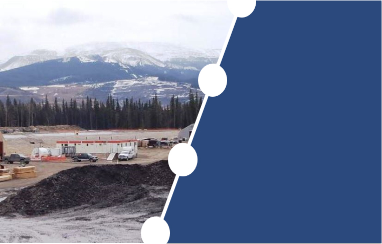
Cover photo credited to HD Mining International Ltd.
© Her Majesty the Queen in Right of Canada, represented by the Minister of Environment and Climate Change.
Catalogue No: En106-155/2016E-PDF
ISBN: 978-0-660-06482-6
This publication may be reproduced in whole or in part for non-commercial purposes, and in any format, without charge or further permission. Unless otherwise specified, you may not reproduce materials, in whole or in part, for the purpose of commercial redistribution without prior written permission from the Canadian Environmental Assessment Agency, Ottawa, Ontario K1A 0H3 or info@ceaa-acee.gc.ca
This document has been issued in French under the title: Projet de mine de charbon de la rivière Murray rapport d'évaluation environnementale
Executive Summary
HD Mining International Ltd. (the proponent) proposes to construct, operate, and decommission an underground metallurgical coal mine located 12.5 kilometers south of Tumbler Ridge, British Columbia (B.C.). The Murray River Coal Project (the Project) would include an underground mine and associated works; waste rock storage facilities; coal rejects storage area; water management structures; coal handling and preparation facilities; rail load-out; sewage treatment and disposal facilities; and an electricity transmission line and a natural gas pipeline, each connecting to existing infrastructure. The Project would have a production rate of six million tonnes of metallurgical coal per year over a 25-year mine life. The coal would be mined using longwall mining, where coal is mined in large panels, typically 1 to 3 kilometers long and 200 to 400 meters wide. The proposed underground mining activity is estimated to correspond to an aboveground footprint of 37 square kilometers. The Project is predicted to cost $300 million and provide approximately 18 600 person-years of employment.
The Canadian Environmental Assessment Agency (the Agency) conducted an environmental assessment (EA) of the Project in accordance with the Canadian Environmental Assessment Act, 2012 (CEAA 2012). The Project is subject to CEAA 2012 because it is described in the Regulations Designating Physical Activities as follows
- The construction, operation, decommissioning and abandonment of a new coal mine with a coal production capacity of 3 000 tonnes per day or more.
The Project was also subject to an EA under British Columbia's Environmental Assessment Act (2002) and an environmental assessment certificate was issued by the responsible provincial ministers on October 1, 2015. The Agency and the British Columbia Environmental Assessment Office coordinated their respective activities to align Aboriginal and public consultation and avoid duplication of effort.
This EA Report summarizes the environmental assessment conducted by the Agency, including the information and analysis on the potential environmental effects of the Project considered by the Agency and the Agency's conclusions on whether the Project is likely to cause significant adverse environmental effects, after taking into account the implementation of mitigation measures. The Agency prepared this report in consultation with Fisheries and Oceans Canada, Environment and Climate Change Canada, Health Canada, and Natural Resources Canada, following a review of the proponent's Environmental Impact Statement by the Agency, departments, Aboriginal groups and the public.
The EA focused on the following valued components as described in subsection 5(1) of CEAA 2012:
- Fish and fish habitat
- Migratory birds
- Current use of lands and resources for traditional purposes by Aboriginal peoples
- Health and socio-economic conditions of Aboriginal peoples
- Physical and cultural heritage and any structure, site or thing that is of historical, archaeological, paleontological or architectural significance for Aboriginal peoples
- Changes to the environment that would occur on federal lands, in another province or outside Canada
The EA also considered the adverse effects of the Project on wildlife species listed in the Species at Risk Act and their critical habitat.
The Agency assessed the potential for the Project to cause significant adverse effects based on information provided by the proponent, federal department expertise, and comments provided by Aboriginal communities and the public.
For construction and operation, the Agency focused its analysis on the following adverse environmental effects:
- Effects on fish and fish habitat as a result of the direct loss or alteration of fish habitat from changes in baseflow from mine dewatering and the effects of subsidence.
- Effects on Aboriginal peoples' health and socio-economic conditions as a result of changes to the environment caused by the Project that may reduce the quality of and access to traditional foods, increase noise, and reduce air quality.
- Effects on Aboriginal peoples' current use of lands and resources as a result changes to the environment caused by the Project on harvested resources (e.g. fish and wildlife), decline in the quality of experience and perceived quality of harvested resources, loss or changes in access to lands used for traditional purposes, and effects on physical and cultural heritage from physical and sensory disturbances.
- Effects on species at risk, including southern mountain caribou and migratory birds, as a result of direct habitat loss or alteration from construction activities, sensory disturbance, and subsidence and direct injury or mortality from vehicle collisions and construction activities.
- Transboundary effects as a result of direct greenhouse gas emissions from the Project.
The Agency has identified key mitigation measures and follow-up program requirements for consideration by the Minister of Environment and Climate Change in establishing conditions as part of a CEAA 2012 decision statement, in the event the Project is ultimately permitted to proceed.
The Agency concludes that, taking into account the implementation of these key mitigation measures, the Murray River Coal Project is likely to cause significant cumulative adverse environmental effects to the use of caribou by Aboriginal peoples. This is because the Project, in combination with other physical activities that have been or will be carried out, will undermine the survival and recovery of the Quintette herd of southern mountain caribou. The Agency also concludes that taking into account the implementation of key mitigation measures, the Project is not likely to cause other significant adverse environmental effects as defined in CEAA 2012.
Table of Contents
- Executive Summary
- Table of Contents
- List of Tables
- List of Figures
- List of Abbreviations and Acronyms
- Glossary
- 1 Introduction
- 2 Project Overview
- 3 Purpose of Project and Alternative Means
- 4 Consultation Activities and Advice Received
- 5 Geographical Setting
- 6 Predicted Changes to the Environment
- 7 Predicted Effects on Valued Components
- 7.1 Fish and Fish Habitat
- 7.2 Migratory Birds
- 7.3 Aboriginal Peoples – Current Use of Lands and Resources for Traditional Purposes
- 7.4 Aboriginal Peoples – Health and Socio-Economic Conditions
- 7.5 Aboriginal Peoples – Physical or Cultural Heritage, and Effect on Historical, Archeological, Paleontological or Architectural Sites or Structures
- 7.6 Transboundary Environmental Effects - Greenhouse Gas Emissions
- 8 Other Effects Considered
- 9 Impacts on Potential or Established Aboriginal or Treaty Rights
- 9.1 Potential or established Aboriginal or Treaty rights in the project area
- 9.2 Potential adverse impacts of the Project on potential or established Aboriginal or Treaty Rights
- 9.3 Proposed Mitigation and Accommodation Measures
- 9.4 Agency conclusions regarding impacts to potential or established Aboriginal or Treaty rights
- 10 Conclusions and Recommendations of the Agency
- 11 References
- 12 Appendices
- Appendix A: Environmental Effects Rating Criteria
- Appendix B: Summary of Environmental Effects Assessment
- Appendix C: List of Key Mitigation Measures, Monitoring and Follow-Up Considered by the Agency
- Appendix D: Mitigation Measures, monitoring and follow-up activities proposed by the proponent
- Appendix E: Aboriginal Consultation Summary
- Appendix F: Summary of Key Comments and Concerns Received on the Draft Environmental Assessment Report from Indigenous Groups
List of Tables
- Table 1 Valued components selected by the Agency
- Table 2 Local and regional study areas by valued component
- Table 3 Aboriginal consultation opportunities during the environmental assessment
- Table 4 Summary of watersheds overlapping the subsidence zone
- Table 5 Predicted water quantity changes in M20 Creek and Mast Creek
- Table 6 Disturbance, during Construction and Operation, to migratory birds in the Local Study Area and Regional Study Area
- Table 7 Saulteau First Nations site-specific values reported in proximity of the mine site footprint
- Table 8 Predicted selenium tissue concentrations for slimy sculpin during Operation at M19A Creek
- Table 9 Maximum sound level for heavy trucks
- Table 10 Predicted noise guideline exceedances at human receptor locations near the Project
- Table 11 Sources of greenhouse gas emissions from the Project after mitigation
- Table 12 Comparison of greenhouse gas emissions at provincial, national and global scales
- Table 13 Potential effects on the habitat of the Quintette herd
- Table 14 Potential effects to maternal roosting habitat for bats
- Table 15 Proponent's risk summary of potential accidents and malfunctions
- Table 16 Summary of past, present and reasonably foreseeable projects and activities identified by the proponent
- Table 17 Effects of Murray River and Hermann Mine projects on M20 Creek streamflow
- Table 18 Cumulative effects to moose, fisher, and grizzly bear
- Table 19 Potential effects on high elevation core habitat and Type 1 matrix habitat based on the cumulative effects assessment aea for caribou (MCP) for the Quintette Herd
List of Figures
- Figure 1: Location of the Project
- Figure 2: Project components and layout
- Figure 3: Fish-bearing creeks and rish barriers in the Local Study Area
- Figure 4: Past, present and reasonably foreseeable projects and activities in the proximity of the Project
List of Abbreviations and Acronyms
- B.C.
- British Columbia
- CEAA 2012
- Canadian Environmental Assessment Act, 2012
- Agency
- Canadian Environmental Assessment Agency
- EA Report
- Environmental Assessment Report
- EA
- environmental assessment
- km
- kilometer
- m
- meter
- Project
- Murray River Coal Project
- proponent
- HD Mining International Limited
- SARA
- Species at Risk Act
Glossary
- Coal seam
- A regularly identifiable layer of coal material located within the geologic stratum. For the Project, there are 5 coal seams of interest.
- Coal rejects
- The waste output of the coal washing process; two types of coal rejects are produced, coarse- and fine-grained, which are planned to be stored in two co-mingled piles on-site.
- Decline
- A ramp constructed from the surface down to the coal seams. For the Project, the decline is designed at an angle of 16 degrees, and is approximately 1 800 meters long.
- Exfiltration gallery
- A series of buried pipes through which treated contact water from the Project is discharged to the receiving environment (i.e. groundwater).
- Flotation clean coal
- An output of the coal washing process; flotation clean coal is a fine-grained component of the clean coal product.
- Gob
- That part of the mine from which the coal has been removed and the space is filled up with waste coal, rock pyrites, slate or other non-merchantable material.
- Middling coal
- An output of the coal washing process; middling coal is a coal product that will be shipped off site. Middling coal is lower quality product than the clean coal product.
- Shaft
- A vertical boring that connects the surface and the coal seams. For some underground mines, shafts are equipped with hoists to move personnel and materials. For the Project, the shafts are used only for ventilation.
1 Introduction
1.1 Purpose of the Environmental Assessment Report
HD Mining International Ltd. (the proponent) proposes to construct, operate, and decommission an underground metallurgical coal mine located 12.5 kilometers south of Tumbler Ridge, British Columbia (B.C.) (Figure 1). The Murray River Coal Project (the Project) would have a production rate of six million tonnes of metallurgical coal per year over a 25-year mine life. The coal would be mined using longwall mining, a method where coal is mined in large panels, typically 1 to 3 kilometers long and 200 to 400 meters wide. The proposed underground mining activity is estimated to correspond to an aboveground footprint of 37 square kilometers. The Project is predicted to cost $300 million and provide approximately 18 600 person-years of employment.
This Environmental Assessment Report (EA Report), prepared by the Canadian Environmental Assessment Agency (the Agency), is being made available for review and comment. Its purpose is to summarize the environmental assessment (EA) conducted by the Agency in accordance with the Canadian Environmental Assessment Act, 2012 (CEAA 2012), including the information and analysis on the potential environmental effects of the Project considered by the Agency and the Agency's conclusions on whether the Project is likely to cause significant adverse environmental effects, after taking into account the implementation of mitigation measures.
1.2 Scope of Environmental Assessment
1.2.1 Environmental assessment requirements
The Project is subject to an EA under CEAA 2012 because it involves activities described in paragraph 16(d) of the Schedule to the Regulations Designating Physical Activities: the construction, operation, decommissioning and abandonment of a new coal mine with a coal production capacity of 3 000 tonnes per day or more.
Based on the project description submitted by the proponent, the Agency initiated a screening of the designated project to determine if an EA was required under CEAA 2012. On April 15, 2013, the Agency invited the public to provide comments on the designated project and its potential environmental effects. The Agency determined that an EA was required on May 30, 2013. The EA commenced on May 31, 2013.
Cooperative environmental assessment approach with British Columbia
The Project was also subject to an EA under British Columbia's Environmental Assessment Act (2002). On October 1, 2015, B.C. issued its EA Certificate for the Project. The Agency and the British Columbia Environmental Assessment Office applied the principles of the Canada-British Columbia Agreement for Environmental Assessment Cooperation (2004) to align Aboriginal and public consultation and avoid duplication of effort. This cooperative approach included a working group comprised of federal and provincial officials, Aboriginal groups, and local governments that informed the conduct of the EA.
1.2.2 Factors considered in the environmental assessment
Pursuant to subsection 19(1) of CEAA 2012, the following factors were considered as part of the EA:
- the environmental effects of the Project, including the environmental effects of malfunctions or accidents that may occur in connection with the project and any cumulative environmental effects that are likely to result from the project in combination with other physical activities that have been or will be carried out;
- the significance of the effects;
- comments from the public;
- mitigation measures that are technically and economically feasible and that would mitigate any significant adverse environmental effects of the Project;
- the requirements of the follow-up program in respect of the Project;
- the purpose of the Project;
- alternative means of carrying out the Project that are technically and economically feasible and the environmental effects of any such alternative means;
- any change to the Project that may be caused by the environment; and
- species listed under the Species at Risk Act (SARA) that may be affected by the Project.
In undertaking the EA, in addition to considering public comments, the Agency considered comments from Aboriginal groups, as well as Aboriginal traditional knowledge.
Figure 1: Location of the Project
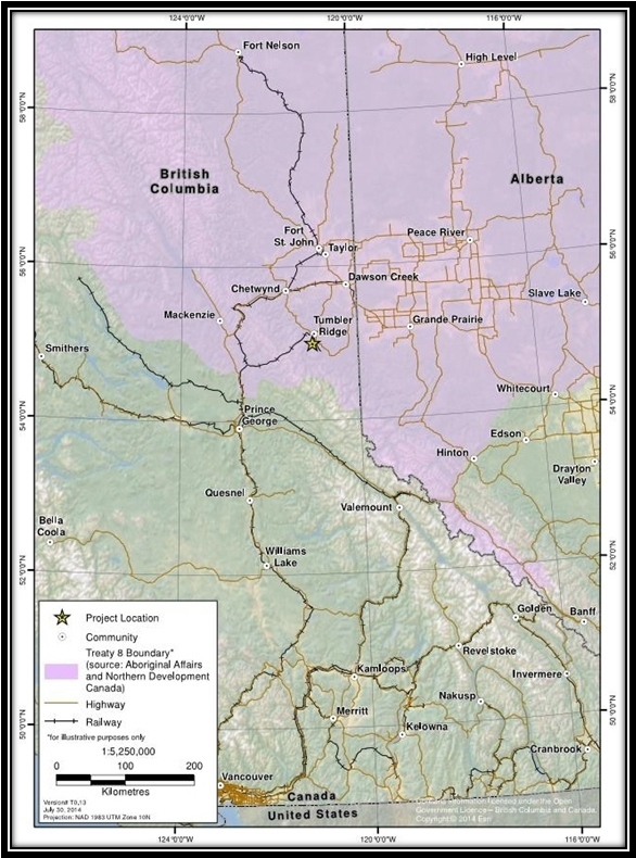
Source: ERM Rescan: October 2014. Murray River Coal Project Environmental Impact Statement
1.2.3 Selection of valued components
Valued components are environmental and socio-economic features that may be affected by a project and that have been identified to be of concern by the proponent, government agencies, Aboriginal groups or the public. The proponent's valued components selection process considered the temporal and spatial scope of the Project and anticipated project-environment interactions. The valued components selected reflect existing knowledge about typical environmental effects of underground mining and potential environmental effects raised by the public, Aboriginal groups and government agencies.
In its analysis, the Agency focused on valued components pertaining to the prediction of environmental effects as defined in subsection 5(1) of CEAA 2012.
No decisions pursuant to other federal legislation that would enable the project to be carried out were identified by any federal authorities at the time of drafting of this report. As a result, analysis of the environmental effects defined under subsection 5(2) of CEAA 2012 was not required.
The EA also considered the adverse effects of the Project on wildlife species listed in the SARA and their critical habitat.
The valued components selected by the Agency to support the assessment of environmental effects under CEAA 2012 and the potential effects on SARA listed species are outlined in Table 1.
| Valued Component | Rationale |
|---|---|
| Potential effects identified pursuant to subsection 5(1) of CEAA 2012 | |
| Fish and fish habitat |
|
| Migratory birds |
|
| Changes to environment on Aboriginal peoples – Health and socio-economic conditions |
|
| Changes to environment on Aboriginal peoples – Current use of lands and resources for traditional purposes |
|
| Changes to environment on Aboriginal peoples – Physical or cultural heritage, and effects on historical, paleontological or architectural sites or structures |
|
| Transboundary environmental effects – _Greenhouse Gas emissions |
|
| Potential effects identified pursuant to subsection 79(2) of the Species at Risk Act | |
| Species at risk |
|
1.2.4 Spatial and temporal boundaries
Spatial and temporal boundaries of an EA are established to define the area and timeframe within which a project may interact with the environment and cause environmental effects. The spatial and temporal boundaries may vary among valued components depending on the nature of the potential Project interaction with the environment.
The proponent defined spatial boundaries as the geographic range over which the Project's potential environmental effects may occur. Local study areas were used to measure baseline environmental conditions and to assess effects on each valued component. Regional study areas were used to measure baseline conditions at a larger scale to assess the maximum predicted geographic extent of effects on each valued component. Table 2 summarizes the Local Study Areas and the Regional Study Areas identified by the proponent for each valued component.
| Valued Component | Local Study Area | Regional Study Area |
|---|---|---|
| Fish and Fish Habitat | This area includes tributary streams, wetlands, and section of the Murray River that are located within and downstream of the Project components and the extent of underground mining. | This area includes the entire Project area and is defined by the Murray and Wolverine rivers to the north and the Murray River upstream of the Project to the south. |
| Migratory birds and Species at Risk | 14,853 hectares – This area includes the project footprint and extends to the height of land or a 1 kilometer buffer around the outer limits of the Project. | 227,616 hectares – This area represents the predicted spatial extent of the direct and indirect effects of the Project on wildlife, including migratory birds. |
| Aboriginal peoples – Current use of lands and resources for traditional purposes | 227,616 hectares – This area represents the predicted spatial extent of the direct and indirect effects of the Project on current Aboriginal use of lands and resources. | 4,291,300 hectares – This area is defined by the Peace River in the north, the Alberta border in the east, and the Continental Divide to the south and west. |
| Aboriginal peoples – Health and socio-economic conditions | 14,853 hectares – This area represents the area surrounding the project footprint within which direct effects from the Project may be anticipated. | 227,616 hectares – This area was selected based on wildlife habitat areas and other ecological factors that overlap with the project footprint. |
| Aboriginal peoples – Physical or cultural heritage, and effects on historical, paleontological or architectural sites or structures | This area includes the project footprint as well as the area above the underground longwall mining where potential subsidence of the land surface could occur as a result of mining. | This area includes the community of Tumbler Ridge and extends to Bullmoose Creek to the north, Bearhole Lake to the east, tributaries of the Sukunka river to the west and Quintette Lake to the south. |
The proponent defined temporal boundaries based on the timing and duration of project activities that could cause environmental effects. The purpose of the temporal boundaries is to identify when an effect may occur in relation to specific project phases and activities. In general, temporal boundaries for this assessment mirror the construction (3 years), operation (25 years), decommissioning and reclamation (3 years), and post-closure (30 years) phases of the Project.
1.2.5 Methods and approach
The Agency reviewed various sources of information in conducting its analysis, including:
- the Environmental Impact Statement submitted by the proponent;
- additional information submitted by the proponent at the Agency's request during the review of the EIS;
- advice from expert departments and agencies; and
- comments received from the public and Aboriginal participants.
The Agency's conclusions on whether the Project is likely to cause significant adverse environmental effects are presented using the methodology prescribed in the Agency's Operational Policy Statement on Determining Whether a Designated Project is Likely to Cause Significant Adverse Environmental Effects under the Canadian Environmental Assessment Act, 2012.
The potential environmental effects of project activities and components were assessed using a standard framework to facilitate individual assessment of each valued component. The analysis began with ranking potential project-valued component interactions and effects. The assessment focused on those interactions that may result in an environmental effect of concern. Evaluation tables were used to describe these interactions and residual project-related environmental effects (i.e. those environmental effects that remain after the planned mitigation measures have been applied) were characterized for each valued component based on the following criteria:
- Magnitude is the scale of the effect relative to the baseline condition.
- Extent is the geographic area over which the effect would occur.
- Duration is the period of time over which the effect would occur.
- Frequency is how often the effect would occur within a given time period.
- Reversibility is the degree to which a valued component would be able to return to its original state (prior to the environmental effect) over the life of the Project.
- Context is the current sensitivity and resilience of the valued component to the change caused by the Project.
The significance of each residual project-related environmental effect was then determined based on pre-defined significance rating criteria (e.g. standards or thresholds). Appendix B summarizes the residual effects assessment for all valued components in relation to anticipated activities of the life cycle of the Project. The analysis of the potential environmental effects of accidents and malfunctions is set out in section 8.2.
The Agency's analysis and conclusions on the significance of environmental effects on valued components are presented in section 7.
The Agency considers effects to be "not significant" where the residual effects after mitigation measures have been implemented are minor or moderate in magnitude; localized in geographic extent; short-term in duration; reversible; and have a low impact on the ecological, socioeconomic, or cultural context.
The Agency considers effects to be "significant" where the residual effects after mitigation measures have been implemented would be major in magnitude; long-term; and would have either a medium or high impact when considering the ecological, socioeconomic, or cultural context.
2 Project Overview
2.1 Project Location
The Project is located approximately 12.5 kilometers southwest of Tumbler Ridge, B.C. It is situated within Treaty 8 and the Peace River Regional District.
2.2 Project Components
The Project includes the following components (see Figure 2):
Underground mine and associated works
Coal would be extracted using a longwall mining method. Two declines and a shaft would be constructed to provide access to the coal seams from the surface. An underground operations hub near the base of the service decline would include a large equipment assembly shop, truck maintenance shop, central underground mine power substation, main drainage pump station, and water sump. During the operation of the mine, two ventilation shafts would be required at the north-west end of the mine. The proposed underground mine area overlaps with Mast Creek and is situated within the Twenty Creek and M20 Creek (Camp Creek) catchments, which flow into the Murray River.
Coal handling and preparation facilities
Key facilities at the Coal Processing Site include a Coal Preparation Plant, Coarse Coal Reject piles, rail loadout, and water management infrastructure. Raw coal would enter the Coal Preparation Plant, be crushed, and then flow through a series of sizing processes. Four streams of material would be produced through the Coal Preparation Plant: clean coal, middling coal, flotation clean coal, and rejects.
Coal Rejects storage areas
The processing of coal would generate reject materials in two waste streams: a coarse fraction and a fine fraction. Fine coal rejects would be subjected to pressure filtration, enabling co-mingled storage of the coarse and fine coal rejects in stockpiles. Coal rejects would be stored in two piles on the east side of the Murray River, situated within the catchments of M19 Creek, M19A Creek, and M17B Creek. The base of each pile would be lined with a geomembrane with a seepage collection system installed on top of the liner. Seepage from these piles would be collected in seepage ponds, and pumped back to the Coal Preparation Plant as supplemental water for the process, or to the Coal Preparation Plant pond. During post-closure, collected seepage would be allowed to migrate from the seepage collection pond into the groundwater system. During Decommissioning and Reclamation, the Coarse Coal Reject piles would be closed and covered with a low permeability layer to limit water infiltration, followed by a top soil layer that would be vegetated.
Coal conveyors
Conveyors would transport the coal from the mining face through the mine and up the Production Decline to the Coal Processing Plant. A series of surface conveyors will move raw coal from the stockpile to the Coal Processing Site, product from the stockpiles to the rail loadout, and rejects from the Coal Preparation Plant to the Coarse Coal Reject piles.
Figure 2: Project components and layout
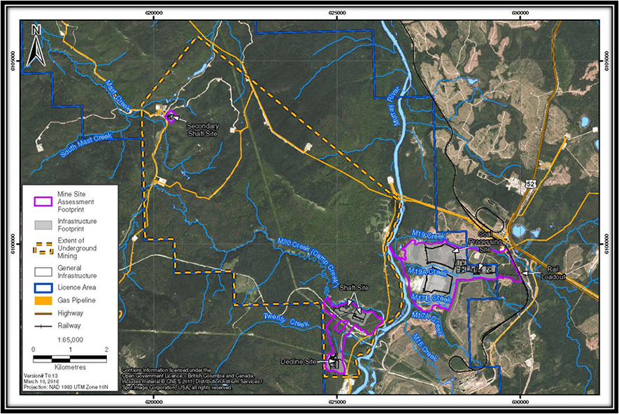
Source: ERM Rescan: October 2014. Murray River Coal Project Environmental Impact Statement
Coal stockpiles
Two raw coal piles are located at the west side of the Coal Processing Site in advance of coal handling and preparation. Two primary clean coal piles would be located at the east side of the Coal Processing Site close to the rail loadout station. Two smaller stockpiles for middlings and flotation clean coal are also planned to be situated within the Coal Processing Site.
Waste rock storage facilities
The majority of waste rock would be generated during the construction of the two declines and the shafts. During Operation, the amount of waste rock generated would be limited, as most of the mining would occur within the coal seam. All waste rock generated during construction and operations of the Project would be classified based on geochemical sampling and analyses and segregated as either potentially acid generating or non-potentially acid generating.
A waste rock pile, which has been constructed at the Shaft Site for Bulk Sample activities, would be utilized to store construction related waste rock. Upon completion of Shaft and Production Decline construction, the waste rock pile would be progressively reclaimed, and a closure cover would be installed over the Shaft Site stockpile. Approximately one-third of all Operation-related waste rock would be stored underground and used as backfill to maximize storage of potentially acid-generating waste rock within the underground mine. The remaining two-thirds of Operation-related waste rock are estimated to be approximately 80 percent non-potentially acid generating. This material would be transported with the raw coal by conveyor through the Production Decline to the raw coal stockpiles at the Coal Preparation Plant, where it would undergo sampling and analysis prior to processing and placement in the Coarse Coal Reject stockpiles.
Overburden and soil storage areas
Overburden and soil storage areas would be located at the Decline Site, the Shaft Site, the Coal Processing Site, and the secondary Shaft Site. This material would be used to support reclamation activities.
Groundwater extraction and distribution facilities
Groundwater that seeps into the mine workings during mining activity would be collected in ditches and pumped to a sump near the underground operations hub. The water would be either re-used underground for dust suppression or transported to the surface as moisture with the raw coal. Excess groundwater inflow would be pumped up the Production Decline for use as process water for the Coal Preparation Plant or to a Total Suspended Solids treatment system. Treated water would be discharged to an exfiltration gallery at the Decline Site on the west side of the Murray River, in compliance with permit requirements.
Contact water collection ditches, sedimentation ponds and water management structures
Contact water collection ditches, sedimentation ponds, and water management structures would be situated at the Decline Site, the Shaft Site, the Coal Processing Site, and the secondary shaft site. Seepage and contact run-off water from the Coarse Coal Reject piles and waste rock stockpiles would be collected and pumped into the Coal Preparation Plant Pond for use at the Coal Preparation Plant. Intake works would be required at the Murray River to provide up to 2 100 cubic meters per day of make-up water to the Coal Preparation Plant during periods of the year when the Coal Preparation Plant Pond cannot supply the required demand.
During Operation, excess contact water from the Coal Preparation Plant Pond and underground mine would be pumped to the Decline Site and released following Total Suspended Solids treatment into an exfiltration gallery on the west side of the Murray River, in compliance with permit requirements. The proponent predicts that following treatment, the quality of the water to be discharged would meet B.C. Water Quality Guidelines for the Protection of Aquatic Life in the receiving environment without secondary treatment for dissolved parameters. If water quality monitoring results indicate trends that exceed the predictions of the effects assessment, the proponent proposes to implement other water storage or treatment measures (e.g. store water underground or metal treatment with lime).
At Decommissioning and Reclamation, plugs would be installed in the declines to minimize groundwater mixing between aquifers. At Decommissioning and Reclamation and Post Closure, contact water would continue to be collected, monitored, and treated as necessary until it can be adequately shown that reclamation objectives have been achieved.
Non-contact water diversion ditch network and sedimentation pond(s)
A non-contact water diversion ditch network and water management structures would be situated at the Decline, Shaft, Coal Processing, and secondary Shaft Sites, diverting runoff around the site and to natural drainages, including M19, M19A, and M17B creeks.
Potable water supply and sewage disposal
Domestic water would be supplied by a well at the Coal Processing Site where it would undergo ozone or ultraviolet treatment to ensure potability. Groundwater wells would provide 399 cubic meters per day of water for domestic use from which 225 cubic meters per day would be discharged to an in-ground septic field (in accordance with provincial legislation).
Explosives use
No explosives would be stored on site; a local company would be contracted to provide any necessary explosives and conduct any blasting activities.
Equipment and fuel storage areas and facilities
Equipment would be located within the underground mine, the Decline Site, the Shaft Site, and the Coal Processing Site. The total annual diesel requirement is estimated at about 468 400 liters. A fuel station and diesel storage tanks would be constructed at the Decline Site to serve the diesel equipment and vehicles. Separate 30 000 liter buried tanks would be installed at the Coal Processing Plant site for the storage of kerosene and octanol, used in the flotation process.
Maintenance, administration and warehouse facilities
The Decline Site would be the primary marshalling area for underground workers, as the Service decline is the main access for personnel and materials to the underground mine. Key facilities at the Decline Site would include a Service decline portal and hoist house, equipment assembly and maintenance shops, electrical substation, and office/administration buildings complex.
Rail loadout
The rail loadout would support mine production of 4.8 million tonnes per year of saleable coal. The facility includes 5 500 meters of track that runs parallel to the existing Canadian National Railway track and a loadout which would be located at the mid-point of the tracks.
Electric transmission line
The proponent has engaged B.C. Hydro to develop a tie-in to an existing 230 kilovolt power line that runs within 1.3 kilometers of the Decline Site. The proponent proposes to construct a 230 kilovolt line from the B.C. Hydro tie-in to a distribution hub at the Decline Site, which would direct power to the surface sites and to an underground substation that would service each underground working area.
Natural gas pipeline
The proponent has engaged Pacific Northern Gas to supply natural gas from its existing network. A pipeline of approximately 800 meters would be installed at the Coal Processing Site while trucks would deliver natural gas to the Decline Site.
2.3 Project Activities
Key activities and schedules associated with construction, operation, decommissioning and reclamation and post-closure of the Project are listed below.
Construction (3 years)
Underground Mine Development
- Excavation of the Production Decline and Underground Operation Hub.
- Development of the connections between Production Decline, Service Decline, Ventilation Shaft, and Underground Operation Hub.
- Construction of Block 1 mainline tunnels in coal seams J and F once access is available.
Surface Infrastructure Development
Development of the Coal Processing Site including:
- Establishment of ditches and sedimentation ponds.
- Land clearing within the Coal Preparation Plant site and Coarse Coal Rejects North footprint areas.
- Stripping of topsoil and subsoil to be stored in stockpiles around the perimeter of the site for reclamation purpose.
- Preparation of the liner and seepage collection system for Coarse Coal Rejects North.
Development of the Coal Preparation Plant including construction of the maintenance workshop, raw coal storage stockpiles, clean coal and middlings stockpiles, flotation clean coal stockpiles, top soil stockpiles, power substation and distribution building, and rail loadout.
Operation (25 years)
- Mining of two long wall working faces simultaneously during full mine operation.
- Processing of raw coal through the Coal Preparation Plant to produce saleable coal and rejects.
- Transport of rejects from the Coal Preparation Plant to the Coarse Coal Reject pile on a conveyer and placement on the Coarse Coal Reject pile.
- Progressive reclamation on Coarse Coal Rejects North.
- Transport of coal from the Coal Preparation Plant to the rail load-out by a series of belt conveyers.
- Transport of coal from the Project to seaports on the B.C. coast via train.
Decommissioning and Reclamation – includes project decommissioning, abandonment and reclamation activities as well as temporary closure and care and maintenance (3 years)
- Covering of Coarse Coal Reject piles with a compacted layer of non-potentially acid generating fine coal reject to reduce infiltration of precipitation, a topsoil layer, and then vegetating the surface with a suitable native seed mixture.
- Closing of each component of the coal processing site, removal of the components from the site, and backfilling of the sedimentation pond.
- Installation of closure plugs in the declines to minimize mixing of groundwater between aquifers.
- Backfilling and sealing of the production and service decline portals, and construction of a concrete pad over the opening.
- Flooding of the mine.
- Closing all mine infrastructure roads when they are no longer required.
Post-closure – includes ongoing reclamation and post-closure activities (30 years)
- Monitoring stability of the waste rock pile and the Coarse Coal Reject piles.
- Ongoing flooding of the mine.
- Ensuring that vegetation has established over reclaimed areas, that no surface erosion is occurring, and that any invasive plants are removed.
- Assessing water quality in seepage collection ponds around the Coarse Coal Reject piles.
- Monitoring groundwater wells annually to assess progress of the flooding of the underground and recovery of the water table.
3 Purpose of the Project and Alternative Means
3.1 Purpose of the Project
The proponent indicated that the purpose of the Project is to develop its core Canadian asset to help meet world metallurgical coal demand and produce benefits to British Columbia. The development of an underground metallurgical coal project would foster economic development opportunities in the natural resources sector.
The proponent expects that the Project would have a substantial and long-lasting benefit for the economies of local communities, British Columbia, and Canada.
3.2 Alternative means of carrying out the Project
Preferred project alternatives were evaluated for the following components based on technical and economic feasibility criteria.
Mining method
The proponent assessed the feasibility of four mining methods: open pit mining, room and pillar underground mining, advancing longwall underground mining, and retreating longwall underground mining. Both open pit mining and room and pillar mining methods were considered to be unsuitable given the depth of the coal seams. Advancing longwall mining presented challenges in maintaining worker safety and achieving the necessary coal production. Retreating longwall mining was considered the preferred option in terms of coal productivity, long-term cost-effectiveness, and underground safety.
Underground access
Accessing mineral at depth is accomplished by using either shafts, or declines, or both. All three options were assessed against the technical requirements necessary to achieve the proposed production rate of six million tonnes per year including, continuous haulage from underground, accessibility for very large equipment, and provision of appropriate air for ventilation.
Access by a combination of a decline and a shaft was the preferred option. As part of the exploration activities for the Project (i.e. Bulk Sample work), the proponent attained a permit for the construction of both a decline and a shaft. The construction of the decline is currently underway. These components were sized to provide safe entrance and exit from the mine and allow for ventilation, passage of persons and materials, and movement of equipment from underground to the surface.
Product transport
Rail and road were considered as options to transport the 4.8 million tonnes per year of coal from the Project to seaports on the west coast. While technically feasible, trucking was considered too costly because of the upgrading costs to roads and bridges to handle the volume of traffic required for the Project. Rail transportation from a dedicated rail loadout, which has been used by the other mining operations in the area, offers a more cost-effective alternative for the Project. The proponent investigated options for the design of the rail loadout and decided on a linear loadout based on minimal new disturbance, efficient loading times, and being the preferred loadout method for Canadian National Railway operations. The proponent also evaluated the effects of locating the stockpile at the plant site versus the loadout. It chose to locate the stockpiles at the plant site because of reduced fugitive dust along the rail line, the concentration of infrastructure in the project footprint, and avoidance of duplicate ancillary facilities.
Coal Reject Storage
The proponent considered three options for managing Coarse Coal Reject, including backfilling into the underground mine, hauling offsite, or storing on-site. On-site storage was selected as the preferred alternative as neither backfilling nor hauling offsite was considered to be economically feasible. Geomembrane liners would be installed under the Coarse Coal Reject piles as part of the seepage collection system to reduce potential effects to the aquatic environment.
Six potential on-site Coarse Coal Reject storage locations were identified and evaluated with the final selection based on its proximity to the rail loadout facility, minimal forest clearing, accessibility by logging road, and use of areas that have already been previously disturbed (i.e. near Teck's Quintette Mine site). During the environmental assessment, the proponent relocated the Coal Processing Plant infrastructure 30 meters to the north of M19A Creek and immediately south of the project license area, thereby avoiding riparian and instream habitat associated with the mainstems of M19A and M17B creeks.
Raw coal transport
The options considered for the transport of raw coal to the Coal Processing Site included: 1) hauling coal to the surface of the Decline Site and trucking it to the Coal Processing Site, 2) hauling coal to the surface at the Decline Site and then using an overland conveyor to the Coal Processing Site, or 3) conveying coal in a second Decline constructed from near the base of the shaft under Murray River and directly to the Coal Processing Site.
Trucking coal from the Decline Site to the Coal Processing Site was rejected for economic reasons. Initially, an overland conveyer was considered to deliver raw coal to the Coal Processing Site, across the Murray River. However, the proponent decided to construct a second Decline under the Murray River with a portal located at the Coal Processing Site, angled down to intersect near the base of the shaft. The preferred option eliminates potential effects to vegetation, wildlife, archaeology, and heritage associated with the movement of coal via an overland conveyer.
Underground explosive storage
The proponent considered two options for explosives storage and use, including an on-site storage or contractor supply. While both options were considered technically feasible, given the sporadic nature and small amount of explosives required, the proponent selected contractor supply and storage as the most preferred option.
Power supply
Following consideration of the B.C. Hydro provincial grid, or an on-site dedicated power plant as options for power supply, the proponent selected the B.C. Hydro provincial grid as the preferred option. This decision was based on the high capital costs of constructing a generator and the available access to tie-in the Project's power supply to B.C. Hydro's 230 kilovolt electric transmission line that passes through the project coal field. The installation of approximately 1.3 kilometers of transmission line would be required.
Heating sources for coal processing
Natural gas was selected as a coal dryer energy source over the use of a coal-powered dryer, as natural gas had less air quality concerns and lower greenhouse gas emissions.
Tailings management
Two alternatives were considered for processing flotation tailings, the disposal of tailings slurry behind a conventional impoundment (i.e. tailings storage facility), or the filtration of tailings to allow disposal by dry-stacking. Tailings storage facilities typically require large surface areas (resulting in different environmental effects), long-term maintenance after mine closure, and greater operating and closure costs. In contrast, the filtration and drying systems can produce "dry-stacked" tailings which for the purposes of the Project, would be co-mingled with the Coarse Coal Rejects and stored in a single waste facility. While the initial costs would be greater due to the investment in the filtration and drying equipment, long-term costs would be minimized. Based on these considerations, filtration of tailings was selected as the preferred approach for processing flotation tailings.
Water sources
Water sources evaluated for the Project were recycled contact water, the Murray River, and groundwater wells. All three sources would be used in various combinations for the Project. A groundwater supply well was installed at the Decline Site during Bulk Sample work. Water from this well may continue to be used to support water demand during construction, or for the sewage treatment system and the decline site. Contact water would be re-used for dust suppression while Coarse Coal Reject runoff/seepage collection would be used as make-up water for the Coal Processing Site. Additional water from the Murray River would be required as make-up to the Coal Processing Site given the seasonable variability in contact water supply.
Sewage final effluent discharge
The selection of an appropriate sewage treatment methodology and effluent discharge location and type was based on the type and flow levels of sewage requiring treatment, site conditions, and effluent discharge requirements. Two locations would require sewage management during the life of the Project: the Decline Site (224 cubic meters per day) and the Coal Processing Site (56 cubic meters per day). These systems would be regulated by the Municipal Wastewater Regulation (B.C. Reg. 87/2012) under the authority of B.C.'s Environmental Management Act (2003). The proponent evaluated the option of discharging into the Murray River or into an in-ground septic system. Discharge into the Murray River would present challenges in attaining regulatory permits given the potential effects to valued components in the receiving environment including aquatic organisms, fish and fish habitat, wildlife, migratory birds and health of local communities. An in-ground septic system would be expected to be equally cost-effective and technically feasible based on soil conditions and experience from an existing septic system at the Decline Site, and, as such, was selected as the preferred option for sewage management.
Contact water treatment and treated water discharge point
The proponent's water quality predictions indicate that secondary treatment is not required. While passive settling ponds were considered as the most cost-effective and preferred treatment option where settling time was allowed and pond capacity was available, this type of treatment was not deemed to be effective in removing fine-grain total suspended solids contained in underground flow, Coarse Coal Reject seepage, and stockpile runoff. Filtration was not considered a suitable alternative treatment method because of the potential for filter clogging, which would necessitate frequent manual filter changes and ongoing manual operation. In contrast, flocculent treatment systems are well-established, cost effective, and adaptable to changing conditions. A flocculent treatment system was selected as the preferred method for managing total suspended solids prior to discharge to the receiving environment.
Based on feedback received during the environmental assessment, the proponent changed the location of the water discharge point from the east side of the Murray River at the Coal Processing Site, to an exfiltration gallery on the west side of Murray River at the Decline Site.
Worker accommodations and transportation
The proponent considered two alternatives for workforce accommodation: an on-site camp and local housing in Tumbler Ridge. While on-site camps are widely used at remote mine sites and experience elsewhere has shown the advantages of providing living and leisure facilities for a large workforce at a single site, the proponent noted the large cost to build, operate, maintain such facilities for a long period of time (i.e. 30 years). Housing of the workforce in Tumbler Ridge is, therefore, the preferred option and proponent has invested $15 million to develop worker housing in Tumbler Ridge.
3.3 Agency analysis and conclusion
The proponent's alternatives assessment considered the cost-effectiveness, technical applicability, reliability, environmental effects, and feedback from Aboriginal groups on the selected alternative means of carrying out the Project. Based on its review of this analysis, the Agency is satisfied that the proponent has sufficiently assessed alternative means of carrying out the Project for the purposes of assessing the environmental effects of the Project under CEAA 2012.
4 Consultation Activities and Advice Received
4.1 Aboriginal Consultation
4.1.1 Aboriginal consultation led by the Agency
The federal government has a duty to consult Aboriginal groups and, where appropriate, to accommodate, when it has knowledge that its proposed conduct might adversely impact an established or potential Aboriginal or Treaty right. Consultation is also undertaken more broadly as an important part of good governance, meaningful policy development and informed decision-making.
These responsibilities are in addition to the requirements under CEAA 2012 to consider the effect of any changes to the environment caused by the Project on Aboriginal peoples. The results of that analysis are set out in sections 7.3, 7.4 and 7.5 of this EA Report. The potential impacts on potential or established Aboriginal rights are discussed in section 9.0.
The Agency identified the following Aboriginal groups for consultation purposes based on the location of the Project and the extent of its potential adverse effects on potential or established Aboriginal and Treaty rights.
- Saulteau First Nations
- McLeod Lake Indian Band
- West Moberly First Nations
- Horse Lake First Nation
- Sucker Creek First Nation
- Blueberry River First Nations
- Prophet River First Nation
- Doig River First Nation
- Fort Nelson First Nation
- Halfway River First Nation
- Kelly Lake Métis Settlement Society
- Métis Nation British Columbia
As the federal Crown Consultation Coordinator, the Agency coordinated consultation activities with the B.C. Environmental Assessment Office to the extent possible, including sharing correspondence, participating in joint meetings with Aboriginal groups, and ensuring that Aboriginal groups were provided with responses to comments and issues raised throughout the process.
The Agency supports Aboriginal participation through its Participant Funding Program. Funds were made available to reimburse eligible expenses of Aboriginal groups that participated in the EA. Eight identified Aboriginal groups applied for and were allocated funding through this program: Saulteau First Nations ( $50 000), McLeod Lake Indian Band ( $50 000), Blueberry First Nations ( $50 000), Sucker Creek First Nation ( $25 500), Horse Lake First Nation ( $50 000) Kelly Lake Métis Settlement Society ( $10 400), and Métis Nation of B.C ( $10 500).
The Agency integrated Aboriginal consultation activities into the EA process to the greatest extent possible. The Agency consulted Aboriginal groups through a variety of methods including phone calls, emails, letters, and in-person meetings and regularly communicated to provide updates on key developments and to solicit input or feedback. The Agency requested written comments from Aboriginal groups on documents described in Table 3.
| Document or Subject of Consultation | Dates |
|---|---|
| Project Description | April 15 to May 6, 2013 |
| Draft Environmental Impact Statement Guidelines | May 31 to June 30, 2013 |
| Environmental Impact Statement | December 18, 2015 to January 29, 2015 |
| Draft EA Report and Potential Decision Statement Conditions | April 13, 2016 to May 13, 2016 |
Appendix E contains a summary of concerns raised by the Aboriginal groups during the EA process and the proponent's and the Agency's responses to those concerns.
Consultation activities related to established Treaty 8 rights
Treaty 8 establishes the right for signatories to "pursue their usual vocations of hunting, trapping and fishing throughout the tract surrendered as heretofore described, subject to such regulations as may from time to time be made by the Government of the country, acting under the authority of Her Majesty, and saving and excepting such tracts as may be required or taken up from time to time for settlement, mining, lumbering, trading or other purposes". The Agency contacted all British Columbia-based signatories to Treaty 8, as well as those Alberta-based members whose traditional territory overlaps with the project area, and invited them to participate in the consultation process.
The Agency determined the appropriate depth of consultation for each group based on the information available in regard to the exercise of established Treaty 8 rights and the potential for adverse effects on those rights from the Project. The depth of consultation determined the type of consultation activities offered to Aboriginal groups through their individualized consultation work plan.
Treaty 8 First Nations – High depth of consultation
Based on existing information available at the time, the Agency determined at the commencement of the EA process in May 2013 that it was appropriate to consult Saulteau First Nations, West Moberly First Nations, McLeod Lake Indian Band, Blueberry River First Nations, and Horse Lake First Nation at the high end of the Haida consultation spectrum. Following receipt of information outlining how its members exercise treaty rights in the project area and an initial assessment of potential impacts to those rights, the Agency consulted Sucker Creek First Nation at the high end of the spectrum beginning in May 2015.
Saulteau First Nations, West Moberly First Nations and McLeod Lake Indian Band collaborated on a technical level throughout the EA process and participated in consultation activities with the Agency as a group. Although information related to environmental effects and impacts to Treaty 8 rights in relation to these three First Nations is presented under the same sub-headings throughout this report, the Agency acknowledges the unique culture and history of each of these First Nations. Where information is available, the Agency has described the varied nature and degree of impacts as a result of the Project that Saulteau First Nations, West Moberly First Nations and McLeod Lake Indian Band members may experience while exercising their Treaty 8 rights.
Saulteau First Nations, West Moberly First Nations, Blueberry River First Nations and McLeod Lake Indian Band were invited to participate in the B.C. Environmental Assessment Office-led Working Group, and other trilateral technical and consultation-related meetings. Horse Lake First Nation and Sucker Creek First Nation were not members of the Working Group; however, the Agency disseminated information as appropriate from those meetings to help inform their understanding of potential impacts to their Treaty 8 rights. The Agency offered one-on-one meetings in writing with Horse Lake First Nation, Sucker Creek First Nation and Blueberry River First Nations; however, no response has been received to date.
As an outcome of consultation meetings with Saulteau First Nations, West Moberly First Nations, and McLeod Lake Indian Band, the Agency assessed impacts to rights considering the seasonal nature of their traditional land use and the timing of project activities. The Agency provided these First Nations with the opportunity to comment on the Agency's draft framework for assessing impacts to rights, and highlight the interconnectivity between rights and the chosen valued components in the context of the seasonal round. The Agency also invited these First Nations to submit technical information and traditional knowledge on project-related effects to valued components important to the practice of their treaty rights and is seeking comments on the assessment of impacts to Treaty 8 rights set out in section 9 of this Report.
Treaty 8 First Nations – Low depth of consultation
The Agency determined that it was appropriate to consult with Prophet River First Nation, Doig River First Nation, Fort Nelson First Nation, and Halfway River First Nation at the lower end of the Haida spectrum, based on information in the Agency's possession regarding the exercise of these groups' Treaty 8 rights and potential interactions with the potential adverse effects from the Project.
Prophet River First Nation, Doig River First Nation, Fort Nelson First Nation, and Halfway River First Nation were invited to comment and review key documents relating to the EA; however, to date, the Agency has not received any comments or feedback from these First Nations.
4.1.2 Consultation activities related to potential Aboriginal rights
Métis groups – Low depth of consultation
Aboriginal groups that were identified as having potential Aboriginal rights that could be adversely impacted by the Project include the Kelly Lake Métis Settlement Society and the Métis communities of Moccasin Flats Métis Society and the North East Métis Society, as represented by the Métis Nation British Columbia.
The Agency determined that it was appropriate to consult both Kelly Lake Métis Settlement Society and the groups represented by Métis Nation British Columbia at the low end of the Haida consultation spectrum. These three groups were invited to comment and review key documents relating to the EA, including the Project Description, draft Environmental Impact Statement Guidelines, the Environmental Impact Statement and the draft EA Report and potential CEAA 2012 decision statement conditions if the Project is ultimately allowed to proceed.
4.1.3 Aboriginal consultation and engagement activities organized by the proponent
Efforts made by the proponent to obtain information about the Aboriginal groups practice of rights and use of resources, as well as the assessment of potential impacts of the Project helped inform the federal government's consultation process. This process included the assessment of potential adverse impacts of the Project on potential or established Aboriginal and treaty rights, and the identification of accommodation measures that may be required to address those potential impacts.
The proponent engaged with the identified Aboriginal groups through meetings, phone calls, emails, correspondence, and by providing responses to concerns expressed during the review of the Environmental Impact Statement. The proponent met with Saulteau First Nations, West Moberly First Nations, and McLeod Lake Indian Band prior to the commencement of the EA process to provide an introduction to the Project. Subsequent meetings with the these groups, as well as with Blueberry River First Nations and Horse Lake First Nation, allowed for discussion about the consultation process, potential effects to the current use of lands and resources for traditional purposes, and cumulative environmental effects.
The proponent undertook socio-economic and non-traditional land use studies with Saulteau First Nations, which informed the assessment of impacts on Saulteau First Nations' treaty rights. The proponent also funded a third party technical review of the Environmental Impact Statement conducted by PGL Environmental Consultants on behalf of the three First Nations. PGL Environmental Consultants submitted technical review comments as part of the Working Group and met with the proponent several times to discuss and address the comments. The proponent committed to continuing the third?party review process during the provincial permitting process, and to developing and implementing work plans with the Saulteau First Nations, West Moberly First Nations, and McLeod Lake Indian Band.
The proponent signed negotiating protocol agreements with Saulteau First Nations, West Moberly First Nations and McLeod Lake Indian Band.
Aboriginal Group views
Saulteau First Nations, West Moberly First Nations and McLeod Lake Indian Band expressed concerns related to the proponent's engagement activities, and the characterization of impacts to their Treaty 8 rights. In particular, the groups were concerned with how information obtained through the Saulteau First Nations Knowledge and Use Study by Olson and Bates (2014) was integrated into the Environmental Impact Statement, and how issues were addressed in the third party technical review process. These groups advised the Agency that consultation and engagement efforts by the proponent were not conducted in a meaningful way. The Agency facilitated meetings that brought the proponent and Saulteau First Nations, West Moberly First Nations and McLeod Lake Indian Band together to discuss potential impacts from the Project on their Treaty 8 rights and the third party technical review.
In May 2015, Horse Lake First Nation wrote the Agency regarding the proponent's approach to consultation, stating concerns with a lack of engagement. The Agency directed the proponent to use a consistent approach to engaging and collecting information for all Aboriginal groups found to be at the high end of the consultation spectrum, including Horse Lake First Nation.
4.2 Public Participation
4.2.1 Public participation led by the Agency
The Agency provided opportunities for the public to comment on the Project Description, draft Environmental Impact Statement Guidelines, Environmental Impact Statement, and draft EA Report. Notices of these opportunities to participate were posted on the Canadian Environmental Assessment Registry's Internet site, and individuals and groups who had expressed an interest in the Project during earlier phases were notified directly. The Agency supported public participation through its Participant Funding Program.
During the Environmental Impact Statement review period, the Agency participated in a public open house with the proponent and representatives from provincial ministries in Tumbler Ridge on January 14, 2015. This session provided opportunities for members of the public to learn and provide comments about the environmental assessment process, the Project and the proponent's Environmental Impact Statement.
Key issues raised by the public and considered by the Agency in the preparation of this EA Report include:
- changes to water quality and soil quality;
- effects to fish and fish habitat, aquatic species, wildlife, birds, species at risk, and vegetation, including wetland habitat loss;
- changes to air quality;
- potential for acid rock drainage and metal leaching;
- effects to human health; and
- effects to paleontological artifacts.
4.2.2 Public participation activities organized by the proponent
The proponent engaged local residents from the community of Tumbler Ridge, and the cities of Chetwynd, Dawson Creek, and Fort St. John. In addition, the proponent consulted other potentially affected or interested stakeholders including commercial and non-commercial land users, service providers, interest groups, and non-government organizations.
Public consultation and engagement activities by the proponent included holding meetings, hosting open houses, conducting interviews, and developing and issuing plain language materials (e.g. fact sheets and comment cards) to share information and receive feedback about the Project.
4.3 Participation of Federal and Other Experts
Federal authorities in possession of specialist or expert information or knowledge with respect to the Project provided advice to the Agency on whether a CEAA 2012 environmental assessment was required. Federal authorities also participated in the review of the draft Environmental Impact Statement Guidelines and the proponent's Environmental Impact Statement, and provided input into the preparation of the draft EA Report and potential CEAA 2012 decision statement conditions.
The following federal authorities provided input:
- Fisheries and Oceans Canada: input on fish and fish habitat that are part of, or support, a commercial, recreational or Aboriginal fishery and provisions related to fish passage and flow.
- Environment and Climate Change Canada: input on air quality, method and location of mine waste disposal, effluent discharges related to mine waste management, geochemistry, water quality and quantity, non-aquatic species at risk, migratory birds, meteorology, climate change, and accidents and malfunctions.
- Natural Resources Canada: input on groundwater quality and quantity, groundwater-surface water interactions, geology and terrain stability, and geohazards.
- Health Canada: input on potential impacts on Aboriginal health related to country foods, water quality, noise levels and air quality.
The Agency and the B.C. Environmental Assessment Office worked closely on the review of technical information, shared key information received from public and Aboriginal participants, and participated in joint meetings with some Aboriginal groups.
5 Geographical Setting
5.1 Biophysical Environment
The project area is located in the Central Canadian Rocky Mountains ecoregion of B.C., within the upper Peace River watershed and is characterized by hills and low mountains with broad valleys incised by rivers and streams. The regional climate is characterized by moderately warm summers and cold winters with mean annual precipitation ranging from 600-700 millimeters, with approximately 30 percent falling as snow.
Surface water quantity and quality
The Murray River flows north from Upper Blue Lake, through the project area, to the Pine River and into the Peace River. Within the project area, the Murray River has a number of small tributaries that drain the surrounding hills and mountains. Downstream of the Project, major Murray River tributaries include Flatbed Creek, Wolverine River and Bullmoose Creek. Streamflow tends to peak between May and July because of spring snowmelt and summer rainfall while low streamflow occurs in the winter and early spring. Many streams have almost no flow from November to March.
Baseline water quality in the project area varies according to seasonal fluctuations of water flow and has been influenced by past and existing industrial activities, including mining exploration and production, oil and gas drilling, and forestry. During the winter, stream water quality is characterized by greater alkalinity, conductivity, hardness, anions (e.g. chloride, fluoride, and sulphate) and some metals (i.e., total boron, molybdenum, selenium, and uranium). Increased runoff and re-suspension of sediment during spring freshet increase suspended sediment with elevated nutrient (i.e., nitrogen, phosphorus), total organic carbon, and metal concentrations. Total aluminum, cadmium, chromium, and iron concentrations were commonly found above provincial water quality guidelines in the project area. Exceedances of Canadian Council of Ministers of the Environment Water Quality Guidelines for the Protection of Aquatic Life or B.C.'s Water Quality Guidelines for the Protection of Aquatic Life were most prevalent during freshet and greatest at the mouth of the streams by the Shaft and Decline Sites on the west bank of the Murray River. Metal concentrations in these streams, the streams on the east bank of the Murray River, and in the Murray River mainstem were found to be within two orders of magnitude above Canadian Council of Ministers of the Environment Water Quality Guidelines for the Protection of Aquatic Life.
Baseline sediment in the Murray River and the streams along its east bank contained metal (e.g. cadmium and nickel) and chemical (i.e. 2-methylnaphthalene and phenanthrene, naphthalene, and chrysene) concentrations that were approximately two and ten times greater than Canadian Council of Ministers of the Environment Sediment Guidelines for the Protection of Aquatic Life, respectively.
Groundwater
In the project area, groundwater flows from the upper foothills towards the Murray River. On either side of the Murray River, creeks and tributaries function as local catchment basins for groundwater flow in or near the project area. Groundwater recharge occurs through precipitation at higher elevations, while valley bottoms serve as groundwater discharge zones. The proponent noted that baseline studies have shown seasonal variations in groundwater levels as great as two meters in the area of the Project.
Fish and Fish Habitat
The Murray River provides habitat for all life-history stages (spawning, rearing, migratory, and overwintering) for the four key fish species present: Arctic grayling, bull trout, mountain whitefish, and slimy sculpin. This system also supports other fish species downstream of Kinuseo Falls (a 60 meter waterfall) including burbot, finescale dace, lake chub, longnose dace, longnose sucker, mountain whitefish, northern pike, and slimy sculpin. Kinuseo Falls is a permanent barrier located approximately 38 kilometers upstream from the Project and represents the upper distribution boundary for fish residing downstream of the falls. Brook trout, rainbow trout, and Westslope cutthroat trout have been introduced to the Murray River system.
The fish community in the Murray River tributary streams (i.e. M17, M19, M19a, and M20) includes Arctic grayling, bull trout, burbot, longnose sucker, mountain whitefish, and slimy sculpin. Brook trout, mountain whitefish, and rainbow trout have been identified in Twenty Creek while finescale dace and lake chub populate wetland environments. Fish distribution in the tributary streams is influenced by ephemeral flow conditions and by the presence of permanent barriers in M17, M19, M20, and Twenty creeks. Beaver dams seem to restrict fish movement from M19 Creek into M19A Creek, since fish were not identified in M19A Creek. In Mast Creek, which drains into the Wolverine River watershed, Slimy sculpin, mountain whitefish and bull trout have been identified in the lower reaches of Mast Creek while only bull trout have been found in the upstream reach just downstream of Mast Road. Barriers to fish passage were not observed below Mast Road, but upstream of Mast Road, a beaver dam at the culvert inlet restricts flow and prevents fish migration into the headwater pond. Figure 3 depicts the location and fish-bearing status of watercourses in the project area.
Measurements of mercury concentrations in fish tissue showed the highest concentrations in fish from the Murray River and the lowest in fish from the tributary streams. All tissue metal concentrations were below federal guidelines for total mercury in fish tissue. Conversely, selenium concentrations were found to be higher in fish from the tributary streams and lower in fish from the Murray River. Mean selenium concentrations from M20 Creek and Mast Creek exceeded the draft provincial guideline of 4 milligram/kilogram Dry Weight for fish muscle during all sampling years. These draft guidelines were also exceeded for mean selenium concentrations sampled in the Murray River.
Wildlife
The landscape provides habitat for a wide variety of wildlife, including ungulates (e.g. caribou and moose), furbearing animals, bats, raptors, songbirds, waterbirds, and amphibians. Six bird species, two mammal species and one amphibian species listed under the Species at Risk Act have the potential to occur in the area of the Project, and five of these species - the olive-sided flycatcher, peregrine falcon (anatum subspecies), western toad, and woodland caribou (southern mountain population) - were observed during baseline wildlife surveys. The proponent also identified nine wildlife species (four birds and five mammals) designated by the Committee on the Status of Endangered Wildlife in Canada as being either present or potentially occurring in the area of the project.
The Project is located in the range of the Quintette herd of the northern ecotype of woodland caribou, southern mountain population. This population is listed caribou as Threatened under the Species at Risk Act as well as on the provincial Red List in British Columbia and has been re-assessed as Endangered by Committee on the Status of Endangered Wildlife in Canada. These animals are known to migrate between high elevation winter habitat and high elevation summer habitat (deeper and higher into the mountains), with transient use of low elevation areas as they move across valleys between adjacent ridges. Low elevation habitat has been identified by the West Moberly First Nation and in Environment and Climate Change Canada's Recovery Strategy for the Woodland caribou, Southern Mountain population (Rangifer tarandus caribou) in Canada (2014) (Recovery Strategy) as an important component to meeting the life requisites of southern mountain caribou. The Project is located within the Quintette herd range of southern mountain caribou and a designated provincial ungulate winter range for caribou overlaps with the wildlife Regional Study Area of the EA.
Figure 3: Fish-bearing creeks and rish barriers in the Local Study Area

Source: ERM Rescan: October 2014. Murray River Coal Project Environmental Impact Statement
5.2 Human Environment
The regional economy is supported primarily by resource extraction industries such as mining and forestry. Other land use activities in the region include agriculture and ranching, manufacturing, mineral exploration, oil and gas drilling, commercial and recreational fishing, trapping and hunting, recreation and tourism (e.g. eco-adventure and guide-outfitting) and transportation. Traditional use of the land by Aboriginal peoples is discussed in section 7.5 of this EA Report.
The mine site is located approximately 12.5 kilometers southwest of Tumbler Ridge and accessible via Highway 52 and the Quintette/Murray River Forest Service Road. Other nearby centers include Chetwynd, Dawson Creek and Fort St. John, which provide services and supplies to much of the region. The nearest Aboriginal communities are outside of the Regional Study Area and include McLeod Lake Indian Band (125 kilometers west), Saulteau First Nations (105 kilometers northwest), and West Moberly First Nations (105 kilometers northwest). While these reserve lands are outside the Regional Study Area, members of the Saulteau First Nations, West Moberly First Nations, and McLeod Lake Indian Band practice traditional land use activities within the Local Study Area and Regional Study Area.
Existing infrastructure in the immediate vicinity of the Project includes a B.C. Hydro transmission line, the Pacific Northern Gas distribution system, a Canadian National Railway line, and various forest service roads. Other nearby land use includes a trapline cabin (1.7 kilometers from the Project on the west bank of Murray River), a campground (9.5 kilometers to the north), Bearhole Lake Provincial Park and Protected Area (17 kilometers to the east), a hunting camp (26 kilometers to the west) and Monkman Provincial Park (27 kilometers to the south).
6 Predicted Changes to the Environment
6.1 Terrestrial Environment
6.1.1 Proponent's assessment
Anticipated effects of subsidence
The proponent indicated that underground mining of coal would cause the surface above to subside. Subsidence occurs when the removal of material beneath the surface influences the state of the surrounding ground, which moves toward and into the empty volume left by the excavated material. As the volume of material removed increases, the amount of deformation and displacement of the ground around it also increases. Subsidence movement can occur vertically and laterally and is always greater in areal extent than the underground workings, but less in vertical extent than the height of the seam being mined. The proponent indicated that the Project is characterized by deep coal seams (450 to 1000m) with strong overlying rocks, which, in addition to the thickness of the coal extracted, would influence the magnitude of movement at the surface.
The underground area would be divided into four large coal Blocks (1 to 4) with each Block consisting of 10 to 30 panels in five coal seams totaling 84 panels and an area of 2 265 hectares combined. For the purposes of the EA, the proponent predicted the total area of the subsidence zone, which takes into consideration a 200 meter buffer from the edge of the panels, to be approximately 2 830 hectares.
The proponent determined that accurately predicting the amount of subsidence and its effects to surface topography would be difficult without site-specific experience from the initial years of coal production at the mine. However, the proponent noted that mining is planned to proceed seam by seam to depth, which will allow any subsidence effects to be generated gradually and will allow early identification of potential problem areas and the design and implementation of mitigation strategies.
Subsidence effects on the environment are likely to include changes to slopes and erosion patterns, which could affect project components as well as natural features such as watercourses, marshes, wetlands, slopes and other features. Contours of estimated subsidence for the entire mine were used to determine the potential effects associated with the predicted zone of subsidence and different valued components, including fish and fish habitat, migratory birds, and species at risk.
Proposed Mitigation Measures, Monitoring and Follow-up
The proponent has proposed measures to reduce subsidence, including:
- Establish mining exclusion zones to protect surface features and infrastructure.
- Modify the amount and sequence of coal extracted to control the amount of surface change as part of adaptive management.
The proponent is committed to monitoring and follow-up measures related to subsidence, to verify mitigation measures and to validate predictions. These measures include:
- Monitoring hydrology and channel morphology in M20 Creek and Mast Creek (later on in the mine life).
- Sampling water quality, sediment quality and aquatic resources in M20 Creek, Mast Creek, and other creeks affected by subsidence.
- Monitoring changes in terrain, including its topography and stability, as well as local terrestrial ecosystems, including herb meadows, forests and wetlands.
- Monitoring changes in surface elevation using high resolution techniques and comparing pre-mining digital terrain models with data collected at various stages over the life of the mine.
- Using satellite radar imagery to detect subsidence effects over wide areas in the later stages of the Project when full subsidence development has occurred.
7 Predicted Effects on Valued Components
7.1 Fish and Fish Habitat
7.1.1 Proponent's assessment
Predicted Effects
The Project is located entirely within the Murray River Watershed. In its Environmental Impact Statement, the proponent predicted that the Shaft and Decline Sites and the Coal Processing Plant Site and Coarse Coal Reject piles could potentially affect fish-bearing creeks and tributaries, including Twenty Creek and M20 Creek, M17, M17A, M17B, M19 and M19A Creeks. The headwaters of Mast Creek, a tributary to the Wolverine River, could also be affected.
Potential effects to fish and fish habitat include direct mortality, erosion and sedimentation, changes in water quality, and habitat loss (including by dewatering and subsidence).
The proponent stated that direct mortality may result from increased fishing pressure from mine personnel, the construction and maintenance of roads and bridges, in-stream works, and the salvage and relocation of fish during maintenance activities. The potential for direct fish mortality is anticipated to be localized, but the proponent indicated that such effects can result in broader effects depending on the fish species, its life history characteristics, and its abundance.
Potential sources of erosion and sedimentation include access roads, the Coal Processing Site, the Shaft and Decline sites, and water management infrastructure sites. High levels of Total Suspended Solids can occur from erosion during construction, maintenance and operational activities, runoff during spring freshet and from summer precipitation, and particulates from construction equipment, road runoff, and dust. The resulting increase in turbidity may alter fish habitat, smother aquatic organisms at various life stages, reduce visibility, diminish feeding efficiency, increase exposure to metal concentrations, and lead to habitat avoidance.
Changes in water chemistry could occur from the discharge of contact water and wastewater, as well as petroleum spills from project-related activities in and adjacent to waterbodies. The proponent indicated that fish exposure to high metal concentrations can lead to mortality. At lower concentrations, metal toxicity in fish can increase stress and impair various physiological functions (e.g. growth, fitness and fecundity), which can affect population dynamics or stability in the long-term. Exposure to certain contaminants in the aquatic environment (e.g. mercury and selenium) has the potential to cause those contaminants to accumulate in fish tissue thereby posing a risk to species higher in the food chain.
Under baseline conditions, the proponent identified several metals that exceeded Canadian Council of Ministers of the Environment Water Quality Guidelines. As a result of project activities, only concentrations of selenium were predicted to exceed Canadian Council of Ministers of the Environment Water Quality Guidelines or B.C.'s Water Quality Guidelines for Aquatic Life. In the month of September for seven years during Operation, seepage from the Coarse Coal Reject piles is predicted to increase selenium concentrations in M19A Creek (0.0024 milligrams per liter) by 336 percent over baseline conditions (0.00055 milligrams per liter) and 140 percent over Canadian Council of Ministers of the Environment Water Quality Guidelines for the Protection of Aquatic Life (0.001 milligrams per liter). Based on the timing (i.e. end of the growing season) and short duration of these exceedances, the proponent concluded that selenium concentrations would not present a significant risk to aquatic organisms.
The proponent characterized habitat loss (including dewatering and subsidence) in terms of the removal of riparian and instream habitat, the loss of habitat productive capacity, and restricted fish passage. These potential effects are expected to occur during the life of the Project due to the upgrade, use and decommissioning of access roads and bridges as well as the construction and operation of project infrastructure. The construction and decommissioning of an intake pumping system to supply water for Coal Processing Plant operations would have the potential to disturb 440 square meters of instream habitat and 1065 square meters of riparian habitat along the east side of the Murray River upstream of M19 Creek. In addition, the proponent predicted potential changes to fish habitat in M19A Creek and M17B Creek resulting from the overlap between the Coarse Coal Reject piles and certain wetland features and non-fish bearing tributaries, which could supply organic material to downstream reaches of M19A.
Changes in water quantity can also result in habitat loss or alteration from underground mine dewatering and subsidence. The spatial extent of subsidence and the watershed boundaries of overlapping streams are shown in Table 4.
| Watershed | Watershed Area (km2) | Mainstem Length (m) | Area of overlap with the subsidence zone (km2; % of watershed) | # of underground coal panels intersecting the stream-line | Maximum subsidence predicted along stream-line (mm) |
|---|---|---|---|---|---|
| M20 Creek | 42.9 | 19050 | 13.8 (32 %) | 23 | 4980 |
| Mast Creek (Mainstem) | 37.3 | 130265 | 6.3 (17 %) | 8 | 2807 |
| Mast Creek (Tributary) | 1.8 | 2065 | 1.6 (90 %) | 12 | 5741 |
Project-related effects on streamflow are predicted to be greatest in M20 Creek and Mast Creek because of reductions in groundwater discharge (baseflow) caused by underground mine dewatering. Potential changes in baseflow were estimated under two scenarios, using data for year 25 of the Project when flow reductions are predicted to be greatest. For the alternate base case scenario [1], the proponent predicted that baseflow at year 25 would be reduced by 44 percent and 51 percent in M20 Creek and Mast Creek, respectively. For the worst case scenario where subsidence would substantively change groundwater flows in addition to the reduction from dewatering, baseflows at year 25 are expected to decrease by 56 percent in M20 Creek and 64 percent in Mast Creek. Table 5 depicts predicted changes in flow under both alternate base case and worst case scenarios, for all potentially impacted streams, during all project phases. The total amount of fish habitat lost as a result of water quantity changes is expected to range from 0.27 - 1.1 percent of total available habitat, depending on the creek, and based upon modeled scenario with a predicted return to baseline conditions within 60 - 200 years after operations cease. The proponent noted negligible changes to total flow (<1 percent) during freshet and early summer when groundwater contributes a significantly smaller proportion of total stream flow.
| M20 Creek at the mouth | Mast Creek | ||||
|---|---|---|---|---|---|
| Baseline | Low flow (m3/s) | 0.05 | - | ||
| Annual flow (m3/s) | 0.48 | 0.005 | |||
| Predicted changes in flow from baseline | |||||
| Alternate Base Case (%) | Worst Case (%d) | Alternate Base Case (%) | Worst Case (%d) | ||
| Construction | Low flow | -10 % | -13 % | -11 % | -15 % |
| Annual flow | -1 % | -1 % | - | - | |
| Operation | Low flow | -27 % | -35 % | -31 % | -40 % |
| Annual flow | -3 % | -4 % | - | - | |
| Decommissioning and Reclamation | Low flow | -44 % | -56 % | -51 % | -64 % |
| Annual flow | -5 % | -6 % | - | - | |
| Post-closure | Low flow | -44 % | -56 % | -51 % | -64 % |
| Annual flow | -5 % | -6 % | - | - | |
Changes in flow are not expected to alter existing stream productivity or benthic invertebrate populations in M20 Creek. The proponent indicated that habitat use by Arctic grayling and bull trout would be marginal during low flow periods when baseline water flows are limiting, and that reductions in stream connectivity could result in the loss of egg incubation and overwintering habitat for slimy sculpin. These effects could indirectly affect the diet and growth dynamics of bull trout.
The proponent confirmed the presence of bull trout and bull trout rearing habitat in Upper Mast Creek within the boundary of the underground mining operation, but noted that deep pools and overwintering habitat are limited. The proponent indicated that since Upper Mast Creek does not provide bull trout spawning and overwintering habitat, effects to bull trout spawning and overwintering are not anticipated. As such, the predicted reductions in flow are not expected to change the opportunity for bull trout to use Mast Creek during spring and summer flow conditions. Bull trout may utilize the lower reaches of Mast Creek for rearing, spawning, egg incubation, and overwintering; however, the proposed mitigation measures are expected to mitigate the predicted effects of reduced baseflow to bull trout (and other fish species) habitat in Mast Creek.
Proposed Mitigation Measures, Monitoring and Follow-Up
Direct mortality effects in fish-bearing streams would be mitigated by complying with federal and provincial best management practices when undertaking access road and site construction and maintenance activities. The proponent indicated it would follow Fisheries and Oceans Canada's guidance on Measures to avoid causing harm to fish and fish habitat (2013) when undertaking construction in fish-bearing streams during appropriate timing windows, salvage fish from work areas, isolate work sites to prevent fish movement into the broader project area, and monitor fish-bearing streams and associated water quality.
Best management practices would be implemented to mitigate the effects associated with erosion and sedimentation during construction and road maintenance. These practices would form part of the proponent's Erosion and Sediment Control Management Plan and would be designed to minimize riparian vegetation effects and maintain fish habitat and stream bank integrity. Key practices would include: using water diversion structures to direct turbid water from the work zone to a sediment control area, installing sediment control structures (e.g. silt fencing, geotextile cloth, straw bales, berms); storing organic and building materials in stable areas away from the channel; constructing banks which are graded at a stable slope; and using erosion control techniques to stabilize excavated materials and areas that were cleared of vegetation (e.g. erosion control blankets, biodegradable mats, planted vegetation, or other).
The proponent would mitigate potential changes to water quality from metal leaching by constructing diversion channels to divert non-contact water away from project infrastructure; placing geomembrane liners underneath the Coarse Coal Reject Piles to minimize infiltration to groundwater; and installing seepage collection systems to capture infiltrated and contact water for reuse in the Coal Preparation Plant. The proponent indicated that excess contact water would be stored in ponds, treated, and discharged when consistent with applicable regulatory requirements. Potential water quality effects related to selenium would be mitigated and managed in accordance with the proponent's Selenium Management Plan and Metal Leaching/Acid-Rock Drainage Management Plan, which would include measures to manage potentially acid generating rock and non-potentially acid generating rock to limit selenium leaching. A follow-up program would also be implemented to regularly monitor Murray River water quality as well as changes to fish tissue and health.
Effects of petroleum products on fish and fish habitat during Construction, Operation, and Decommissioning and Reclamation are discussed in section 8.2 - Accidents and Malfunctions.
For the potential loss or degradation of fish habitat, additional mitigation measures include following all applicable Fisheries and Oceans Canada operational statements, and applying appropriate riparian buffer zones in accordance with B.C.'s Forest and Range Practices Act (2002c). For the proposed intake infrastructure on the Murray River, the proponent would evaluate the type of activities required in the riparian area and determine if these activities would be subject to Fisheries and Oceans Canada review prior to their initiation. Such activities, including the salvaging of fish and dewatering, would be isolated and supervised by an environmental monitor. The timing of activities would occur at low water levels to reduce any potential adverse effects to fish.
To avoid instream and riparian habitat loss, the proponent committed to locating the Coal Processing Site a minimum of 30 meters to the north of M19A Creek and establishing a 30 meter buffer around M17B Creek.
Potential habitat loss caused by changes in water quantity related to subsidence and groundwater drawdown would be mitigated through the construction of instream weirs. Once in place, the proponent would conduct regular hydrometric measurements and surveys to quantify potential reductions in baseflow, and to confirm that flow objectives are being met (i.e. wetted area and pool depth). These activities would be undertaken in concert with the mitigation and follow-up measures, including associated monitoring, outlined in the proponent's Subsidence Management Plan. Should the mitigation measures prove to be ineffective, additional measures, including the construction of additional weirs and supplemental flow programs would be explored through discussions with Fisheries and Oceans Canada.
Measures to address the potential increase of fish harvesting by mine personnel include the implementation of a company "no-fishing" policy for all mine employees and contractors, the installation of gates and security measures to prohibit entry to the project area by unauthorized vehicles, and the deactivation of unused roads during the Decommissioning and Reclamation phase.
Predicted Residual Effects
After the implementation of mitigation measures, the proponent does not predict residual effects to fish and fish habitat from direct mortality, erosion and sedimentation, or changes in water quality.
The proponent did predict residual effects resulting from the reduction in baseflow in M20 Creek and Mast Creek. Reduced baseflows may result in the decrease or loss of fish habitat during low flow periods, which would reduce stream connectivity and important habitat for bull trout (i.e. adult and juvenile rearing), Arctic grayling (i.e. adult and juvenile rearing) and slimy sculpin (i.e. egg incubation and overwintering). The loss of slimy sculpin habitat could affect the population and productivity of slimy sculpin and indirectly affect bull trout that use M20 Creek and Mast Creek. The proponent predicted these residual effects to be of low magnitude, medium duration, regular in frequency, local in geographic extent, and reversible over the long-term. Uncertainty remains, however, regarding the extent and likelihood of adverse effects of subsidence on baseflow reductions in both M20 Creek and Mast Creek.
The proponent predicted residual effects to fish and fish habitat in the section of Murray River where the water intake structure is proposed, noting that there would be temporary disturbances to instream and riparian habitat, temporary increases in total suspended particulates, and changes to existing flows. The proponent indicated that although suitable Arctic grayling rearing habitat was observed in the area, this type of habitat is common in the Murray River mainstem; therefore, following implementation of mitigation measures, no significant adverse effects to fish or fish habitat are expected. Effects are expected to be of low in magnitude, short in duration, local in geographical extent and reversible in the short-term.
7.1.2 Views expressed
Federal Authorities
Fisheries and Oceans Canada expressed concerns about the potential for serious harm to fish from streamflow changes in M20 Creek and Mast Creek and requested that the proponent undertake further analyses on water quantity changes to support the assessment of effects on fish and fish habitat. Fisheries and Oceans noted that M20 Creek and upper Mast Creeks are both fish-bearing and currently experience low winter flows. Slimy sculpin and other potential fish species are known to overwinter in M20 Creek and presumably in upper Mast Creek and these overwintering fish are susceptible to increased stress and potential mortality from lowering of flow under ice flows. Fisheries and Oceans requested the proponent to identify the potential effects to fish in M20 Creek and Mast Creek as a result of subsidence, and recommended that the proponent incorporate measures that would signal potential problems in advance of any unauthorized serious harm to fish.
The proponent recalibrated its hydrologic model to estimate the risks to fish and fish habitat when flow reductions in low flow periods are predicted to be greatest and proposed the construction of instream weirs in each of M20 Creek and Mast Creek to mitigate predicted baseflow reductions. Fisheries and Oceans Canada stated that the construction of a single weir on Mast Creek would not be sufficient to fully mitigate the risk of overwintering fish mortality and recommended that the proponent establish a fish and fish habitat baseline monitoring program in Mast Creek and undertake baseline flow monitoring prior to any project dewatering activities. Based on additional fish surveys information collected by the proponent in Mast Creek, which indicated the presence of bull trout as well as overwintering and rearing bull trout habitat, Fisheries and Oceans questioned the effectiveness of the proposed rock weirs given the uncertainty regarding the location of these weirs relative to fish habitat potentially affected by reduced flows. Fisheries and Oceans, therefore, recommended that the proponent continue to locate and quantify existing pool habitats in Mast Creek downstream of the Mast Creek Road and design additional mitigation measures to maintain current conditions of all bull trout overwintering habitats potentially affected by flow reductions.
Environment and Climate Change Canada noted that the underlying geology was not well defined, and inhibited the understanding of spatially-representative geochemistry as it relates to the Project. It was noted that sample selection and the demonstration of representativeness, both spatially and chemically, in addition to the inadequate provision of sample material led to a need for the proponent to rely upon analogs and to make analytical assumptions. This approach reduced the confidence in the proponent's geochemical characterization to adequately describe the geology, as well as the water quality predictions in and around the project area. Environment and Climate Change Canada requested that the proponent address these deficiencies to better understand the extent of project-related effects on water quality and in turn, fish and fish habitat as well as the effectiveness of water quality-related mitigation measures. Environment and Climate Change Canada questioned what measures the proponent would undertake should monitoring results from the Metal Leaching/Acid Rock Drainage Management Plan indicate that adjustments to waste rock management would be required. The proponent provided the geochemical information requested by Environment and Climate Change Canada and referenced a series of management plans with measures that, once implemented, would mitigate and monitor for potential effects associated with metal leaching and acid rock drainage. If monitoring results were to indicate deviations from predictions, the proponent stated that it could implement additional measures such as changing the criteria for blending potentially acid generating and non-potentially acid generating material to offset metal leaching and acid rock drainage, and reclaiming the Coarse Coal Reject piles to reduce infiltration. Environment and Climate Change Canada indicated that there remained areas of uncertainty regarding project geology and geochemical characterization, and in turn, the potential effects of project activities on water quality and fish and fish habitat.
Natural Resources Canada requested the proponent to provide additional information to evaluate the potential effects of mine operations on groundwater quality and in turn, surface water quality of water bodies containing fish and fish habitat. The proponent was also requested to clarify inconsistencies in its conceptual water balance model to show the contribution of water from different water bodies that report to the Murray River, to demonstrate a linkage between the underground mine and surface water (i.e. groundwater-surface water interaction), and to provide an updated analysis of water quality predictions and mitigation measures based on revised model inputs and considerations. The proponent provided additional information that addressed Natural Resources Canada's concerns regarding groundwater quality predictions and the assumptions the proponent used in its water balance model. Natural Resources Canada did not indicate any further issues regarding groundwater-surface interactions.
Natural Resources Canada also requested additional information pertaining to groundwater-surface water interactions around the Coarse Coal Reject piles. This information was considered important to evaluate how the Coarse Coal Reject piles could affect groundwater flow patterns and groundwater quality in M19 Creek and M19A Creek and how groundwater drawdown could affect surface water bodies containing fish and fish habitat. The proponent responded by providing additional information describing how groundwater drawdown and subsidence have been incorporated into its groundwater model as well as groundwater-surface water interactions for project components that were not directly incorporated in the model. Natural Resources Canada did not indicate any further issues regarding groundwater-surface interactions related to the Coarse Coal Reject piles.
Health Canada also requested the proponent to provide results of supplemental sampling results from various locations on Murray River that would increase the representativeness of baseline fish tissue concentrations. The proponent provided the requested information, which responded to Health Canada's concern regarding baseline fish tissue concentrations.
Aboriginal Groups
Saulteau First Nations, West Moberly First Nations, and McLeod Lake Indian Band indicated that the Project has the potential to affect fish and fish habitat in M19 Creek, M19A Creek, M17B Creek, M20 Creek and Mast Creek, as a result of habitat removal, changes in water quality and flows, and subsidence. They noted that since fish have been confirmed to be present in areas of Mast Creek overlapping the predicted zone of subsidence, the proponent should utilize Mast Creek-specific data to model changes in flow to more adequately assess potential effects to fish and fish habitat. They also questioned the potential effects of project-related erosion on the beaver dam currently blocking fish passage into M19A Creek, and commented on the lack of fish sampling in M19A Creek tributaries. They expressed concern regarding the proponent's proposed mitigation measures and adaptive management plans to manage the effects of subsidence on fish and fish habitat and noted that project-related activities, including vibrations from blasting, vehicles operating in water, and changes in water quality, all have the potential to affect fish spawning. Based on these concerns, the Aboriginal groups requested that the proponent develop an Offsetting Plan to compensate for any removal of fish habitat and consider the cumulative effects to fish and fish habitat in the Murray River and associated tributaries.
Saulteau First Nations expressed concerns that the Project would likely affect Arctic grayling and spawning habitat in M19 Creek and that these effects could affect Saulteau members' ability to harvest Arctic grayling. They also highlighted the difficulty in evaluating the fish and fish habitat without adequate hydrology and fish and fish habitat sampling data for Mast Creek and noted that project-related activities could affect fish health. Horse Lake First Nation requested that the proponent provide a rationale for why a cumulative effects assessment was not conducted for fish and fish habitat in light of the predicted loss of fish habitat.
All Aboriginal groups, including Sucker Creek First Nation, noted concerns regarding potential effects to fishing rights and current use, which are discussed in section 9 and 7.3.
The proponent responded to these concerns by proposing mitigation measures to address habitat loss, changes in flow, changes in water quality, and subsidence. The proponent committed to constructing instream weirs to mitigate habitat loss, updating the Subsidence Management Plan, and conducting additional analyses to address concerns regarding changes to water quantity.
Public
The public did not provide comments related to fish and fish habitat.
7.1.3 Agency analysis and conclusion
Analysis of effects
The Agency agrees with the proponent's view that there would be no residual effects from direct mortality and erosion and sedimentation after the implementation of the best management practices and mitigation measures proposed by the proponent.
The Agency is of the view that residual effects to Arctic grayling, bull trout and other fish species may occur as a result of the changes in selenium concentrations in M19A Creek during part of the Operation phase of the Project. Elevated selenium concentrations are predicted to occur in M19A Creek periodically and over a short duration (i.e. only in the month of September for seven years during Operation), but these concentrations are expected to exceed both Canadian Council of Ministers of the Environment Water Quality Guidelines for the Protection of Aquatic Life and background conditions. The Agency notes that although the proponent indicated that timing of the predicted increase of selenium concentrations would coincide with the end of the growing season for benthic invertebrates and other aquatic resources, there remains a degree of uncertainty in relation to the potential for bioaccumulation in fish and sub-lethal toxicity to fish eggs and larvae. This uncertainty is further compounded by concerns regarding the completeness of the proponent's geochemical characterization program to inform water quality predictions and effects. The Agency agrees with Environment and Climate Change Canada that the gaps in the geochemical characterization program for the Project need to be addressed in order to confirm the extent of potential effects to water quality and fish and fish habitat. Any additional geochemical information that is collected should be used to update water quality predictions and associated mitigation measures.
Given these considerations, the Agency is of the view that the implementation of a follow-up program to verify the accuracy of predicted changes in fish tissue metal concentrations in M19A Creek and M19 Creek and the effectiveness of mitigation measures, is necessary with respect to project-related effects of selenium on fish and other aquatic resources. This program should, at a minimum, include actions that would be taken during the life of the Project to avoid, prevent, and mitigate potential effects of selenium as well as reporting and notification requirements with government bodies and Aboriginal groups.
With regard to the potential effects associated with the loss of fish habitat, the Agency is of the view that there is a high degree of uncertainty associated with subsidence and its contributions to baseflow reductions in M20 and Mast Creeks. Depending on the nature and extent of subsidence events, there is potential for changes in baseflow that could result in greater flow reductions than modelled predictions in the expected base case scenario. These residual effects are likely to affect fish and other aquatic organisms, particularly in Mast Creek, where flows are predicted to be greatly reduced under the worst case scenario (~64 percent). In addition, the Agency acknowledges that there remains some uncertainty around the potential effects to fish and fish habitat in Upper Mast Creek, including overwintering habitat for bull trout.
The Agency is of the view that technically feasible instream rock weirs in M20 and Mast Creeks, a Fish and Fish Habitat follow-up program, and measures in the proposed Subsidence Management Plan would be appropriate to limit the reduction in overwintering habitat in the two creeks. The Agency agrees with Fisheries and Oceans' recommendation that multiple rock weirs in Mast Creek would be required, recognizing the larger area that would be affected relative to M20 Creek and the greater potential loss of overwintering habitat. In addition, the Agency considers the identification and quantification of overwintering habitat within Mast Creek essential components of a follow-up program to confirm that the proposed rock weirs and other mitigation measures are in the right locations to effectively attenuate the predicted flow reductions and reduce any effects to resident bull trout. Since longwall mining is not planned until Year 15 of Operation, the Agency notes that any experience in the installation and effectiveness of weirs identified through monitoring in M20 Creek should be applied to the proposed weirs in Mast Creek. Based on these considerations, the residual effects to fish and fish habitat from flow reductions from project-related activities and subsidence are expected to be moderate.
The Agency is of the view that adherence to applicable Fisheries and Oceans Canada's measures to avoid serious harm to fish and fish habitat and other best management practices when undertaking instream or riparian activities would be effective in preventing potential adverse effects to fish and fish habitat. The Agency agrees with the proponent's view that with the implementation of instream measures, the construction and decommissioning of the water intake structure is likely to result in low level and short-term residual effects to instream and riparian habitat along the Murray River.
Key Mitigation Measures to Avoid Significant Effects
The Agency has considered the mitigation measures proposed by the proponent, expert federal advice from federal authorities, and comments from Aboriginal groups and the public in identifying the following key mitigation measures as necessary to ensure no significant adverse effects to fish and fish habitat:
- Implement erosion and sediment control measures (e.g. sediment fences, straw bales, check dams) during all phases of the Project to limit the release of sediment into receiving environment.
- Install, prior to mining activities in the Mast Creek and M20 Creek watersheds and in consultation with Fisheries and Oceans Canada, rock weirs in Mast Creek and M20 Creek to mitigate predicted baseflow reductions, and protect existing fish and fish habitat, including bull trout (Salvelinus confluentus) overwintering habitat. Prior to weir installation, quantify and locate pool habitats in Mast Creek, downstream of Mast Creek Road and in M20 Creek to inform the design, number and location of the rock weirs.
- Implement measures to protect fish and fish habitat when undertaking construction activities near water, consistent with Fisheries and Oceans guidance and in consultation with Fisheries and Oceans Canada.
- Install silt fences and other sedimentation traps prior to the construction of the intake pumping system work area and upon completing the construction of the system, revegetate the work area by using native species.
- Conduct site dewatering activities during low flow periods and, if required, fish salvage in accordance with the Fisheries Act and its regulations.
- Implement measures, including placing a low permeability liner at the base of the Coarse Coal Reject piles, capturing water infiltrating the Coarse Coal Reject piles into a seepage collection, segregating waste rock based on potentially acid-generating potential and blending of potentially acid generating and non-potentially acid generating materials from the Coarse Coal Reject piles, and placement of low permeability closure covers for waste rock and Coarse Coal Reject piles, to minimize the release of selenium concentrations in the aquatic environment that could affect fish health.
- Collect contact water runoff from project infrastructure, including the waste rock pile, the Coarse Coal Reject piles, coal stockpiles, and Shaft Sites, into the sedimentation ponds and treat the contact water at the settling ponds, prior to the release into the environment, taking into account the Canadian Council of Ministers of the Environment Water Quality Guidelines for the protection of Aquatic Life and the B.C. Water Quality Guidelines for the Protection of Aquatic Life.
Follow-up
The Agency has considered the follow-up and monitoring programs proposed by the proponent, expert advice from federal authorities, and comments received from Aboriginal groups and the public in identifying the following follow up programs necessary to verify the predictions of effects to fish and fish habitat and the effectiveness of mitigation measures:
- Monitoring potential adverse effects of the Project to fish and fish habitat to confirm that mitigation measures are functioning as planned, including:
- Instream rock weirs to verify they are meeting proposed objectives (i.e. wetted area and pool depth) to mitigate the predicted flow reductions and protect fish and fish habitat in M20 Creek and Mast Creek.
- Habitat protection measures for construction activities near water, dewatering and salvage (if required) activities, and installation and decommissioning of the intake pumping system.
- Completing the geochemical characterization for the Project, updating the geochemical information during all phases of the Project, and re-evaluating the water quality model taking into account the updated geochemical data.
- Monitoring of water quality within the area of the Project to verify the water quality model predictions and the predicted effects to fish and fish habitat.
- Characterizing selenium leaching potential from waste rock, coal stockpiles, Coarse Coal Reject piles, and tailings.
- Monitoring changes in selenium concentrations in water, sediment, benthic invertebrates and fish tissue at locations including M17B, M19A Creek, M19 Creek, M20 Creek, Twenty Creek, Murray River and a control site.
- Monitoring the magnitude and patterns of subsidence and the effects of subsidence on hydrology, groundwater, water quality, and ground and slope stability.
Conclusions
Taking into account the implementation of the mitigation measures described above, the Agency is of the view that the Project would not result in significant adverse effects on fish and fish habitat.
7.2 Migratory Birds
7.2.1 Proponent's assessment
Predicted Effects
The proponent stated that migratory birds, including species at risk olive-sided flycatcher, Canada warbler, rusty blackbird, and common nighthawk, have been observed throughout the project area, and may experience adverse effects during all project phases, including habitat loss and alteration, direct mortality, and sensory disturbance. The potential effects to other birds listed under the Species at Risk Act are discussed in section 8.1.
The majority of the bird habitat losses and alterations resulting from project activities are expected to occur at the Shaft and Decline Site, Coal Processing Site, North and South Mine Sites, and Secondary Shaft Site. Site clearing during Construction and Operation has the potential to remove and alter habitat that is used by songbirds, waterbirds, cavity-nesting waterfowl and riverine birds. The proponent noted that songbirds are particularly sensitive to changes in forest stands, snags and other debris in otherwise open areas, and that waterbird habitat could be affected by the degradation of wetlands resulting from changes in water flow, particulate deposition, and seepage from sedimentation ponds. The proponent also predicted that cavity-nesting waterfowl and riverine birds may be affected by the loss and alteration of mature forest and riverine habitat, respectively, during Construction and Operation. The predicted extent of habitat loss and alteration is depicted in Table 6.
Changes to topography due to subsidence also have the potential to alter bird habitat during Operation. Construction activities could result in direct mortality of migratory birds through clearing of vegetation being used for nesting. Bird mortality can occur through the destruction of bird nests and eggs and through direct contact with project equipment or falling debris. The proponent noted that migratory bird eggs and nests are protected under the Migratory Birds Convention Act (1994) as well as the B.C. Wildlife Act (1996b).
Sensory disturbance to migratory birds can occur as a result of continuous noise during Construction and Operation and from vehicular traffic. The proponent explained that elevated noise levels can result in the functional loss of habitat, as auditory communication (e.g. breeding calls, territorial calls, and the localization of mates and young) is disrupted and nests may be abandoned to avoid noisy areas. The proponent also indicated that to avoid noise, birds spend more time flying , which increases predation rates and energy use, thereby decreasing foraging time and reproductive success. The majority of noise disturbance during Operation would be associated with the operation of the Shaft and Decline Site. The proponent predicted that during Operation, 61.6 hectares of high-quality songbird habitat, 8 hectares of suitable waterbird habitat, 93 hectares of suitable cavity-nesting waterfowl habitat, and 4 km of suitable riverine bird habitat, would be functionally lost. In addition, artificial light can attract birds during nocturnal movements, resulting in disorientation and increased risk of direct mortality.
| Type of migratory bird | Total high quality suitable habitat | Local Study Area | Regional Study Area | |||||||
|---|---|---|---|---|---|---|---|---|---|---|
| Local Study Area | Regional Study Area | High quality habitat lost or altered in mine site footprint | Percent of high quality lost or altered (%) | High quality habitat lost or altered in subsidence zone | Percent of high quality lost or altered (%) | High quality habitat lost or altered | Percent of high quality lost or altered (%) | High quality habitat lost or altered in subsidence zone | Percent of high quality lost or altered (%) | |
|
[1] Length-of-stream kilometers |
||||||||||
| Songbirds | 4 006 ha | 13 081 ha | 237 ha | 5.9 | 539 ha | 13.5 | 237 ha | 1.8 | 539 ha | 4.1 |
| Waterbirds | 257 ha | 3 720 ha | 46 ha | 17.9 | 33.4 ha | 12.9 | 46 ha | 6.9 | 33.4 ha | 0.9 |
| Cavity-nesting waterfowl | 7 566 ha | 106 614 ha | 149 ha | 2.9 | 1 005 ha | 13.2 | 149 ha | 0.1 | 1 005 ha | 1.0 |
| Riverine birds | 119 km [1] | 1 851 km | 5.9 km | 5.0 | 16.2 km | 13.6 | 5.9 km | 0.3 | 16.2 km | 0.9 |
While selenium concentrations in M19A Creek and the wetland habitat between the Coal Processing Site and the Murray River were predicted to exceed B.C. Water Quality Guidelines for the Protection of Wildlife, the proponent indicated that most songbirds would achieve their water intake through the ingestion of prey up the food chain (e.g. insects).
The proponent indicated that waterbirds may potentially use storage ponds during Operation which are predicted to contain concentrations of selenium and other contaminants that exceed B.C. Water Quality Guidelines for the Protection of Wildlife. Exposure to high concentrations of these contaminants can lead to a variety of adverse physiological responses, including reduced reproductive success and mortality.
Proposed Mitigation Measures, Monitoring and Follow-Up
The proponent proposed a Wildlife Management Plan that presented mitigation measures to minimize the adverse effects to wildlife species, including migratory birds. As part of this plan, the proponent would address habitat loss and alteration and direct morality by establishing thirty meter buffer zones around active nests to prohibit their destruction or disruption, scheduling vegetation clearing activities outside sensitive bird breeding periods, and undertaking revegetation and reclamation of certain components (e.g. wetlands) during the Decommissioning and Reclamation of the Project. Where vegetation clearing cannot be conducted outside of the sensitive bird breeding windows, the proponent committed to conducting pre-clearing surveys to identify nests to be avoided prior to clearing activities during the nesting season.
The proponent did not include specific measures to mitigate potential subsidence effects on migratory birds and their habitat, but would undertake topographic monitoring of subsidence, to improve the predictive capacity to support execution of the mine plan and follow-up requirements. The proponent would also implement a terrestrial monitoring program to monitor the effects of subsidence on local terrestrial ecosystems (e.g. herb meadows, forests and wetlands), including changes in terrain topography and stability and on terrestrial components, including soils, vegetation, and wildlife habitat use. Results of the monitoring program would be reported annually as part of the proponent's annual reclamation report and would serve to inform follow-up requirements.
The proponent's measures to reduce the effects of noise include limiting excessive noise generating activities during sensitive periods for birds and using silencers and mufflers on vehicles or other Best Available Control Technologies to dampen traffic noise. The proponent indicated that it would also impose speed limits for Project on-site roads, conduct regular vehicle maintenance, and consider noise specification when selecting project-related equipment to minimize noise during the operation of equipment. The proponent committed to monitor noise at various wildlife receptor locations to support follow-up activities to confirm predictions of noise effects and determine if the proposed mitigation measures need to be refined.
As part of the Wildlife Management Plan, the proponent proposed to monitor the quality of standing water in the project area (i.e. implement a water monitoring program, maintain inspection and maintenance records, ensure water monitoring reporting) and implement wildlife exclusion measures if migratory birds and other wildlife are observed to be in contact with contaminated water or hazardous liquids. The proponent's mitigation measures outlined in its Groundwater and Surface Water Management Plan and Selenium Management Plan are expected to mitigate potential effects to water quality, which in turn, would minimize the effects of contaminants on waterbirds. Key measures include the re-use of Coarse Coal Reject pile seepage from the seepage collection system for the Coal Processing Plant, the installation of structures to divert non-contact water and enable the collection and reuse of contact water for project activities, segregation of waste rock based on acid-generating potential, blending of acid generating and non- acid generating materials to limit generation of acid leachate from the Coarse Coal Reject piles, and installation of organic or geomembrane liners to cover the waste rock piles and Coarse Coal Reject piles to prevent water infiltration and selenium leaching.
Predicted Residual Effects
The proponent did not predict residual effects to migratory birds following the implementation of the proposed mitigation measures.
7.2.2 Views expressed
Federal Authorities
Environment and Climate Change Canada indicated that the proponent's proposal for pre-clearing surveys to locate nests during the breeding season is not recommended as such surveys create disturbance. As an alternative, it was recommended that the proponent follow Environment and Climate Change Canada guidance for determining the presence of nests (http://ec.gc.ca/paom-itmb/default.asp?lang=En&n=8D910CAC-103_1).
Environment and Climate Change Canada expressed concern regarding the proponent's survey effort in identifying all migratory and non-migratory birds and their habitat that may be potentially affected by the Project at both the local and regional scales. Environment and Climate Change Canada indicated that the frequency of proponent surveys were not likely to detect seasonal and inter-annual variation, or peak migration periods and were limited in coverage to small portions of the Local Study Area and Regional Study Area.
Environment and Climate Change Canada recommended that the proponent conduct additional surveys in multiple years, taking into account the survey standards established by the provincial Resources Information Standards Committee and the migration and nesting periods for migratory birds.
Environment and Climate Change Canada also indicated that the direct mortality of migratory birds should include vehicle-related mortality given that the Project would result in an increase in both vehicular and train traffic.
The proponent responded with commitments to conduct additional migratory bird surveys in spring 2016, and to refine mitigation measures as part of the development of environmental management plans during the provincial permitting process. With regard to potential effects of direct mortality of birds due to vehicular and train collisions, the proponent stated that the projected increase in traffic would be too small to cause measurable effects on migratory birds and that direct mortality by train collisions would be unlikely given the low number of trains required by the Project (one per day), the reduced speeds at which trains would be travelling (<50 km/h), and the use of an existing transportation corridor. The proponent committed to implementing road and traffic management measures as part of its Wildlife Management Plan, including enforcing speed limits on project access roads and monitoring for avian mortality. Based on the proponent's response, Environment and Climate Change Canada did not indicate any further issues regarding migratory birds.
Aboriginal Groups
Saulteau First Nations, West Moberly First Nations, and McLeod Lake Indian Band disagreed with the proponent's conclusions that no residual effects to migratory birds would occur and indicated that the Project had the potential to result in adverse cumulative effects to wildlife, including migratory birds. They also disagreed with the proponent's use of only black-throated green warbler to represent all songbirds occurring in the LSA, indicating that a combination of other bird species/habitat types would have provided a more accurate representation of potential habitat loss for avifauna. Horse Lake First Nation expressed concern that single year data for songbirds did not provide a confident assessment of the presence and distribution of the various species in the area, and questioned what measures the proponent would implement to deter waterbirds from using the water storage ponds and how these measures would be monitored.
The proponent asserted that it has engaged with First Nations in an iterative process to resolve issues related to the Project, including those regarding migratory birds. The proponent noted that opportunities for addressing uncertainty and for refining mitigation measures would be undertaken as part of the development of environmental management plans, including the Wildlife Management Plan, during the provincial permitting process. The proponent committed to monitoring waterbird use of the surface water ponds and implementing deterrent measures should monitoring results indicate actual waterbird use.
Public
The public did not provide comments related to migratory birds.
7.2.3 Agency analysis and conclusion
Analysis of effects
The Agency agrees with the proponent that there would be no residual effects to migratory birds resulting from direct mortality and chemical hazards after the implementation of mitigation measures.
The Agency disagrees with the proponent's conclusion of no residual effects resulting from habitat loss and alteration and sensory disturbance to migratory birds, including the Canada warbler, olive-sided flycatcher, rusty blackbird, and common nighthawk.
For the Canada warbler, the Agency acknowledges that the amount of breeding habitat lost or altered is a small percentage of total habitat available in the Local Study Area and Regional Study Area. However, the Agency is of the view that the habitat to be cleared during Construction would be lost for the life of the Project and that the habitat altered by project-related activities is not likely to recover until reclamation activities are underway. Breeding birds would likely be displaced from preferred local habitat sites, although the Agency acknowledges the availability of high-quality breeding in the Regional Study Area (13 081 hectares). The Agency is also of the view that residual effects to habitat may occur due to subsidence. The Agency notes the proponent's uncertainty of how habitat quality would change within the zone of subsidence and is unclear how the proposed mitigation measures would account for and address the range of potential effects to migratory birds and their habitat in the event that subsidence does occur (i.e. complete loss or alteration to partial alteration of habitat). The Agency considers the residual effects of habitat loss and alteration to be low in magnitude, long-term, and localized, as the removal of forest stands and snags and the subsidence zone would be isolated to certain areas of the mine footprint (e.g. Shaft and Decline site, Coal Processing Site, underground mining footprint).
Similar residual effects are expected to occur for olive-sided flycatcher and rusty blackbird since the proponent predicted residual effects to fisher and grizzly bear habitats, which were used as proxies to assess effects to both olive-sided flycatcher and rusty blackbird. The Agency acknowledges that the mine footprint is predicted to result in the loss of 304 and 112 hectares of high-quality habitat for fisher and grizzly bears, respectively, with the majority of this loss occurring in low elevation areas comprising riparian and mature stands of forests ideal for olive-sided flycatcher and rusty blackbird. In addition, subsidence is predicted to remove or alter an additional 528 and 1396 hectares of high-quality fisher and grizzly bear habitat, respectively. While these losses are small relative to the amount of high-quality habitat available in the Regional Study Area (28 736 and 116 504 hectares, respectively), the Agency notes that the proponent does not expect comparable habitat (i.e. high value forest habitat) to be reclaimed and restored until many years following Post-Closure. As such, the Agency views progressive reclamation of the project area as a key mitigation measure to replace high-value and functional habitat for olive-sided flycatcher and rusty blackbird that would be destroyed by project activities.
The proponent did not report common nighthawk in its baseline studies although potential breeding habitat was either identified or considered likely to occur in both the Local Study Area and the Regional Study Area. With limited ground verification and survey results, pre-construction surveys may be necessary to determine the presence or absence and distribution of common nighthawk and to implement measures to mitigate any effects should the species be detected.
The Agency agrees with the proponent that continuous noise during Construction and Operation activities and from vehicular traffic noise has the potential to disturb migratory birds and alter their behaviour. The Agency acknowledges that songbirds may become habituated to project-related activities and human presence over time, but are likely to be adversely affected if they are unable to perform biological functions because their songs are masked by excessive long-term noise. In addition, the Agency notes that facility lighting during construction and operation, particularly after dusk or before dawn, may have minor effects on migratory bird populations. The Agency is of the view that localized, low level residual effects to migratory birds from sensory disturbance are likely to occur during Construction and Operation.
Key Mitigation Measures to Avoid Significant Effects
The Agency has considered the mitigation measures proposed by the proponent, expert advice from federal authorities, and comments received from Aboriginal groups and the public in identifying the following key mitigation measures as necessary to ensure there are no significant adverse effects to migratory birds:
- Carry out all phases of the Project in a manner that protects and avoids harming, killing or disturbing migratory birds or destroying or taking their nests or eggs, including adhering to the breeding period for songbirds and waterbirds. In this regard, the proponent shall take into account Environment and Climate Change Canada's Avoidance Guidelines for Migratory Birds. The proponent's actions in applying the Avoidance Guidelines shall be in compliance with the Migratory Birds Convention Act (1994) and with the Species at Risk Act.
- Control lighting required for Construction and Operation of the Project, including direction and timing to avoid effects on migratory birds, while meeting operational health and safety requirements.
- Verify, prior to construction, the presence and distribution of migratory birds and the use of migratory bird habitat within the area of the Project, taking into account standards established by the provincial Resources Information Standards Committee. Develop the methodology for migratory bird surveys in consultation with relevant federal and provincial authorities.
Follow-up
The Agency has considered the follow-up and monitoring programs proposed by the proponent, expert advice from federal authorities, and comments received from Aboriginal groups and the public in identifying the following follow up programs necessary to verify the predictions of effects to migratory birds and the effectiveness of mitigation measures:
- Monitoring interactions between project activities and migratory birds and their nests, in consultation with federal and provincial authorities, to determine the effectiveness of mitigation measures to avoid harm to migratory birds, their eggs and nests and to verify the use by migratory birds of the subsidence zone.
Conclusions
Taking into account the implementation of the mitigation measures described above, the Agency concludes that the Project would not result in significant adverse effects on migratory birds.
7.3 Aboriginal Peoples – Current Use of Lands and Resources for Traditional Purposes
The Agency assessed the potential effects of changes to the environment on the current use of lands and resources for traditional purposes of Aboriginal peoples. The traditional activities considered in the assessment include fishing, hunting, trapping, gathering, and the use of habitations, trails, and cultural and spiritual sites.
7.3.1 Proponent's assessment
Predicted Effects
The Project has the potential to cause changes to the environment that would affect the current use of lands and resources for traditional purposes during Construction, Operation, and Decommissioning and Reclamation.
Fishing
In conducting its assessment, the proponent considered whether the Project would change the ability to access fishing areas along the Murray River and near Kinuseo Falls as well as the quality of the experience of fishing in those areas. The proponent indicated that Saulteau First Nations and Horse Lake First Nation members fish in the Local Study Area along the Murray River, including areas in very close proximity to the mine site. The proponent indicated in the Environmental Impact Statement that consultation efforts and the review of secondary information did not identify evidence of current fishing use of the Local Study Area for McLeod Lake Indian Band, West Moberly First Nations, Blueberry River First Nations, Kelly Lake Métis Settlement Society, Métis Nation British Columbia, Doig River First Nation, Prophet River First Nation, Halfway River First Nation, Fort Nelson First Nation, and Sucker Creek First Nation.
While the proponent noted that there may be temporary access road closures during Construction, the potential effects to fishing activities would be negligible to minor because any closures would be temporary and isolated occurrences.
Project-related activities are expected to create noise and change the visual landscape, which may lead to a lower quality fishing experience and possible avoidance of fishing areas along the Murray River. In addition, Aboriginal groups may perceive the fish in local watercourses to be contaminated from changes in water quality due to seepage from project components.
The proponent predicted that project-related effects to fish and fish habitat associated with flow reductions in M20 Creek and Mast Creek have the potential to affect bull trout, Arctic grayling and overwintering habitat for slimy sculpin. These effects, however, are not expected to affect fish abundance or distribution, and in turn Aboriginalfishing activities, as the instream rock weirs and other measures proposed by the proponent are expected to maintain current flow conditions for fish and fish habitat. More information related to the potential effects to fish and fish habitat is described in section 7.1 of this Report.
Hunting/trapping
In conducting its assessment, the proponent considered whether the Project would change the ability to access hunting and trapping areas, as well as the quality of the experience of carrying out those activities and the potential changes to harvesting success of preferred species in preferred areas. West Moberly First Nations, McLeod Lake Indian Band, Blueberry River First Nations, Horse Lake First Nation, Sucker Creek First Nation, and Kelly Lake Métis Settlement Society all hunt in the Local Study Area. Saulteau First Nations members hunt within the mine site footprint, and use trails and roads in very close proximity to the Project, as well as the Murray River Forest Service Road.
The proponent concluded that access may be temporarily affected through isolated and temporary closures of the Murray River Forest Service Road during Construction, but otherwise there would be no changes to access outside of the mine site footprint. Aboriginal groups would, however, no longer have access to hunting areas within the mine site footprint.
The proponent anticipates that sensory disturbance would reduce the quality of hunting and trapping experience and lead to avoidance of preferred areas for hunting and trapping by Aboriginal harvesters. Aboriginal community members may also perceive local wildlife as being contaminated by mining activity. Habitat loss and alteration, and changes to wildlife movement are predicted to reduce hunting and trapping success for moose, grizzly bear and fisher.
The proponent did not predict residual effects to caribou, and considered caribou a high-elevation species while the Project is located at a low elevation. The proponent therefore did not include use of caribou in the assessment of effects on current use of lands and resources for traditional purposes. Further analysis of potential effects on is set out in section 8.1.1. Similarly, elk was not included in the assessment. Residual effects to elk were not predicted because the Project would result in relatively small loss of habitat and/or disruption to elk movement.
Gathering
In conducting its assessment, the proponent considered whether the Project would change the ability to access gathering areas as well as the quality of the experience and potential avoidance of preferred areas. Consultation efforts and the review of secondary information has not identified evidence of current gathering use of the Local Study Area for McLeod Lake Indian Band, West Moberly First Nations, Blueberry River First Nations, Kelly Lake Métis Settlement Society, Métis Nation British Columbia, Doig River First Nation, Prophet River First Nation, Halfway River First Nation, Fort Nelson First Nation, and Sucker Creek First Nation. Saulteau First Nations harvest plants and firewood and gathers berries within the mine site footprint and Local Study Area, and Horse Lake First Nation harvests medicinal plants from the Tumbler Ridge area in the Local Study Area.
As previously noted, temporary and isolated closures of access roads during Construction are expected to have negligible to minor effects. Aboriginal groups would no longer have access to gathering areas within the mine site footprint.
The Project may result in reduced quality and potential avoidance of gathering areas due to sensory disturbance and perceived contamination of plants and berries. Vegetation clearing for the Project is expected to remove 287 hectares of potential harvestable plant habitat and thereby reduce the overall availability of the resource for gathering.
Use of habitations, trails and cultural and spiritual sites
The proponent anticipates that Project-related activities have the potential to affect use of habitations, trails, and cultural and spiritual sites by Saulteau First Nations. The mine site footprint overlaps with a camp area, a trail and a spiritual site used by Saulteau First Nations. The Local Study Area also includes a sacred site containing a graveyard, as well as a trail along Mast Creek in the Local Study Area.
The proponent considered whether the Project would change the ability to access habitations, trails, and cultural and spiritual areas. The proponent predicted that the effects of temporary and isolated access road closures during Construction would be negligible to minor. Access to use of cultural and spiritual areas on the mine site footprint would be restricted until the Project is decommissioned (approximately year 31).
The Project would also result in noise and changes to the visual landscape, which may, in turn, affect use of habitations, trails, and cultural and spiritual sites within the Local Study Area.
Proposed Mitigation Measures, Monitoring and Follow-Up
The proponent proposed to mitigate potential effects to the current use of lands and resources for traditional purposes by providing advance notice of temporary closures to the Murray River Forest Service Road to Aboriginal groups. The proponent committed to engage Saulteau First Nations members about continued access to the camp site and sacred site within the mine site footprint, subject to safety considerations.
To control fugitive dust emissions, the proponent proposed to cover or enclose stockpiled materials and vehicle loads to reduce airborne dust, install a sprinkler system that would release small droplets of water (i.e. 100 microns) to suppress dust, reduce drop heights when unloading materials, optimize the shape of stockpiles to reduce loss of moisture content, and install a wet deduster that would recover coal particles from the coal dryer. For unpaved roads, the proponent also proposed to enforce vehicle restrictions, water roads, undertake road maintenance and enforce local speed limits.
Other actions include notifying Aboriginal groups of anticipated timing of noisy activities, sharing results of environmental monitoring programs in relation to contamination of traditional foods, revegetating exposed soil surfaces with native seeds of the area, involving Aboriginal members in ongoing monitoring activities, and completing a visual impact assessment to further assess the potential effects of project infrastructure on current use activities in adjacent areas.
The proponent also committed to support First Nations caribou recovery initiatives as part of the Peace Northern Caribou Plan and the joint work plan being developed through the First Nations Independent Technical Review.
Predicted Residual Effects
After implementation of mitigation measures, the proponent did not predict any residual effects to access to traditional use areas for hunting, fishing, gathering, or use of habitations, trails or spiritual sites.
The proponent predicted a moderate, but not significant, residual effect to the quality of experience for fishing, hunting and trapping, gathering, and using habitations, trails and cultural and spiritual sites due to noise and changes to visual perspective for Saulteau First Nations, West Moberly First Nations, Horse Lake First Nations, Sucker Creek First Nation and Kelly Lake Métis Settlement Society. However, the extent of these effects remains uncertain as the proponent did not ground-truth specific traditional use areas to determine whether auditory or visual changes would occur.
The proponent predicted that the magnitude of the reduction in the quality of resources harvested in the Local Study Area would be minor, including fish (Saulteau First Nations, Horse Lake First Nation), wildlife (Saulteau First Nations, West Moberly First Nations, Kelly Lake Métis Settlement Society) and plants and berries (Saulteau First Nations). However, the proponent noted the outstanding concerns of Aboriginal groups about the effects of effluent releases into the Murray River, coal dust on vegetation and into water, and use of herbicides. As a result, the proponent predicted a moderate, but not significant, residual effect to the perceived quality of fish, wildlife, plants and berries harvested in the Local Study Area for Saulteau First Nations, West Moberly First Nations, Horse Lake First Nation, Sucker Creek First Nation and Kelly Lake Métis Settlement Society.
The proponent identified moderate, but not significant residual effects to harvesting by McLeod Lake Indian Band, Saulteau First Nations, West Moberly First Nations, Blueberry River First Nations, Horse Lake First Nation, Sucker Creek First Nation and Kelly Lake Métis Settlement Society in preferred areas of moose, grizzly bear, and fisher due to effects to habitat and disruption of wildlife movement. A moderate, but not significant, residual effect to gathering success for Saulteau First Nations was also predicted due to the loss of harvestable plants, effects of subsidence on soil and vegetation diversity, and deposition of dust on vegetation.
7.3.2 Views expressed
Federal Authorities
Environment and Climate Change Canada acknowledged the mapping information provided by the West Moberly First Nations showing the overlap between the low elevation range of southern mountain caribou and the proponent's wildlife Local Study Area, and mine site footprint. It noted that the lack of recent caribou observations in the mine site footprint did not imply that the area was not necessary to the survival and recovery of the species, and that the Project was likely to destroy critical habitat for southern mountain caribou as described in the Recovery Strategy for that population.
Aboriginal Groups
Saulteau First Nations, West Moberly First Nations and McLeod Lake Indian Band
Saulteau First Nations, West Moberly First Nations, and McLeod Lake Indian Band expressed general concerns about the lack of information provided in the proponent's assessment and the mischaracterization of their current uses for traditional purposes in the Environmental Impact Statement. They stressed the importance of key wildlife species, including caribou to both tangible and intangible (i.e. cultural and spiritual) aspects of current use and advocated for a proponent commitment to develop a mitigation and monitoring plan to address potential effects to these species. The plan would involve Saulteau First Nations, West Moberly First Nations and McLeod Lake Indian Band community members as key participants in the implementation of mitigation and monitoring activities.
The three groups also articulated how and why the Project may affect the current use of lands and resources in the context of the seasonal round, which is the pattern of activities and resource uses that is followed each year. In the spring season, Saulteau First Nations, West Moberly First Nations and McLeod Lake Indian Band hunt, trap, fish and collect vegetation important for medicinal, subsistence, and cultural purposes. Access to some traditional use areas is generally good in the spring because there is minimal logging traffic, although there is poor access to fishing areas because of traffic associated with industrial development in the area. Deciduous brush cover is important for calving areas, as well as to mask the scent of both these areas and mineral licks from predators. Vegetation in the spring is also critical to the maintenance of a proper diet for wildlife and for good moose meat quality and furbearer pelt quality. They also noted concerns about the uptake of contaminants by plants and resulting effects to animal health throughout the year, observing that if medicinal plants were removed from the landscape, the animals would not return.
In the summer season, these groups hunt, trap, fish and collect berries. They shared the concern that sensory disturbances (i.e. noise and scents) in the summer would affect the ability of wildlife to successfully raise their young, and thus ultimately affect their hunting opportunities and success. Aboriginal groups stated that summer construction overlaps with preferred hunting schedules and that the presence of workers due to construction or mining operations would inhibit the members' hunting, trapping or berry collecting activities. Finally, these groups expressed concerns in regard to the potential effects of vibration (subsidence) and noise from the Project causing the decline of insect and plant health. The decline of insect health is seen as interconnected with fishing that contributes to the likelihood of fish to jump, which is one of the visual indications community members look for when selecting a good fishing spot.
In the fall season, these groups continue to hunt, trap, fish, and gather berries and medicinal plants. Vegetation available in the fall may be important for moose health, which can affect hunting success. For example, the Aboriginal groups consider fireweed to be an important source of medicine for pregnant moose that contributes to successful calving and a healthier population of moose, which communities depend on to exercise their right to hunt and related uses throughout the year. Concerns were raised regarding the general decline of moose populations and meat quality, as observed by hunters and other community members. Plants and ecosystems that support moose health are extremely important to these First Nations as moose harvested in the recent past have sometimes been diseased and deemed unsuitable for human consumption. Members evaluate moose health and the quality of moose hide in deciding whether to hunt because moose possess cultural and spiritual value for communities beyond the sole purpose of subsistence. These Aboriginal groups also noted that smell is extremely important to the ability of both community members and animals to locate prime berry patches, and that the presence of dust from the Project could interfere with harvesting.
The winter season is a preferred time for trapping (the highest quality pelts are found in the late winter/early spring), ice fishing, and collecting wood. These groups identified the importance of harvesting caribou during the late winter months, as other harvested species such as moose are often not available or are of poorer quality during this time. Due to a self-imposed moratorium on caribou harvesting, they have observed increased pressure on alternative hunting activities. They noted that building roads could expose minerals and attract animals, which could exacerbate collisions in the winter, expressed concerns about snowmobiles adversely affecting winter trapping opportunities, and emphasized the importance of year-round access to trap lines, campsites, graveyards and trails.
These groups also stressed that the practice of traditional activities is dependent on the availability of high-quality resources, which in turn, are dependent on the interactions with other components of the environment. Aboriginal groups described a holistic approach to the use of land and resources that considers the interrelationships between species, their environment, and people. They also indicated that not all areas of current use for traditional purposes are created equal; some areas potentially affected by the Project support a range of interconnected activities. In addition, traditional knowledge indicates that the ecosystems supporting certain rare plants, which may serve as powerful medicines, are not easily reclaimed and the plants are difficult to successfully transplant.
Saulteau First Nations, West Moberly First Nations, and McLeod Lake Indian Band all identified the potential for impacts related to health, socio-economic conditions, and intangible aspects of culture as a result of changes to the environment associated with the Project. The evaluation of effects to Aboriginal health and socio-economic conditions is described in section 7.4 of this EA Report. With regard to the intangible aspects of the current use of lands and resources for traditional purposes, the Aboriginal groups expressed concerns related to the adverse cumulative effects on culture, including the loss of the intergenerational transmission of knowledge and language, degradation of social structures and systems of reciprocity, and cessation of spiritual practices as a result of adverse effects on land and resources, particularly with respect to the hunting of caribou. They emphasized that their well-being and identities are strongly tied to the land and ecosystem, such that any adverse effects would ultimately affect the tangible and intangible aspects of their culture.
Horse Lake First Nation and Sucker Creek First Nation
Horse Lake First Nation expressed concerns about project-related effects to fishing, and hunting of ungulates (e.g. moose) and furbearers (e.g. fisher). Sucker Creek First Nation indicated that members use the mine site footprint and surrounding areas for traditional activities including hunting and gathering and that project activities have the potential to affect members' use of the area.
Public
The public did not provide comments related to the current use of lands and resources for traditional purposes by Aboriginal peoples.
7.3.3 Agency analysis and conclusions
Analysis of effects
Saulteau First Nations, West Moberly First Nations, and McLeod Lake Indian Band
The Agency considered the proponent's Environmental Impact Statement and related documents, as well as traditional and other knowledge provided by the Saulteau First Nations, West Moberly First Nations, and McLeod Lake Indian Band during the EA to evaluate the potential effects of changes to the environment caused by the Project on the current use of lands and resources for traditional purposes. An overarching theme expressed by these groups is that the current use of the land goes beyond hunting, trapping, and collecting vegetation, and extends to being out on and fostering a spiritual and cultural relationship with the landscape.
The Agency notes that the definition of "current use" allows for the consideration of uses that may have ceased due to external factors, but may be reasonably expected to resume once conditions change. As such the Agency has considered the potential effects to current use related to caribou, despite the proponent's conclusion of no residual effects of the Project on and the self-imposed moratorium on caribou harvesting by these First Nations.
Change in access or use of land and resource areas
The Agency is of the view that, after taking into consideration the implementation of mitigation measures, the Project is not likely to cause any adverse environmental effect to the access to fishing, hunting and trapping areas along the Murray River Forest Service Road and other roads in the Local Study Area. The Project is not expected to affect navigation of Murray River. The Agency acknowledges that there may be isolated incidences where the Murray River Forest Service Road may be temporarily closed for construction purposes. Access to harvesting areas from the Murray River Forest Service Road, Highway 52 and other roads in the region would otherwise be unimpeded.
The Agency is of the view that the Project is likely to cause a low adverse residual effect, which is not significant, to Saulteau First Nations' access to habitations, gathering, and cultural or spiritual sites identified in the mine site footprint of the Project. The proponent's proposed engagement with the Saulteau First Nations about access to these sites is considered appropriate to mitigate the potential effects of restricted access to lands used by Saulteau First Nations members.
The Agency acknowledges that Saulteau First Nations' members actively use the Project area, including the mine site footprint for subsistence and cultural/spiritual purposes (see Table 7) and would no longer have access to that area. The proponent's proposed engagement plans should include protocols for providing access to the sacred and camping sites located in the mine site footprint, as well as to areas where medicinal plants are identified, subject to safety considerations.
| Type of Values | Within 250 m of the mine site footprint | Within 5 km of the mine site footprint | Within 25 km of the mine site footprint | |||
|---|---|---|---|---|---|---|
| # of values | % of reported values | # of values | % of reported values | # of values | % of reported values | |
| Cultural/Spiritual | 3 | 4 | 13 | 11 | 51 | 17 |
| Environmental | 11 | 15 | 17 | 15 | 43 | 14 |
| Habitation | 2 | 3 | 5 | 4 | 35 | 11 |
| Subsistence | 44 | 61 | 64 | 56 | 155 | 50 |
| Transportation | 12 | 17 | 16 | 14 | 25 | 8 |
| Total | 72 | 100 | 115 | 100 | 309 | 100 |
The Agency is of the view that the Project is likely to cause an adverse but not significant effect to West Moberly First Nations' access to preferred and important elk hunting area within the Coarse Coal Reject area of the mine site footprint. Restricted access to the mine site footprint is expected to affect West Moberly First Nations members' ability to hunt elk by changing elk harvesting patterns as members must increase their dependence on other hunting areas in the region. The proponent should engage with West Moberly First Nations on ways to maintain West Moberly First Nations' access to the elk hunting areas.
Reduction in the quality of experience and perceived reduction in the quality of resources
The Agency agrees with the proponent's predictions that the Project is likely to cause an adverse but not significant residual environmental effect to the quality of experience of Aboriginal peoples' fishing, hunting, and gathering opportunities and practices, and the use of habitations, trails and cultural and spiritual sites. Project-related noise while audible at local fishing sites and at nearby trapline cabins, is not predicted to be sufficiently loud to cause community members to avoid these sites. However, the Agency acknowledges that Aboriginal groups value a tranquil environment for the practice of traditional activities and that changes to the landscape and sensory disturbance associated with the Project, including noise, traffic, light, and the presence of non-Aboriginal people, have the potential to alter the sense of place and in turn, disrupt one's ability to maintain connections to the land and carry out traditional activities.
The Agency agrees with the proponent's assessment that there would be residual effects associated with the perceived reduction in the quality of aquatic and terrestrial resources throughout the Local Study Area and that these effects are expected to prompt some Aboriginal members to alter their harvesting behaviors. The Agency is of the view that these changes in harvesting behavior are likely to result in the loss or impairment in the ability of Aboriginal members to carry out their traditional activities in areas that have been normally considered suitable for such activities.
Reduced hunting, trapping and gathering success
The Agency agrees with the proponent's assessment that the Project has the potential to affect the success of Aboriginal harvesting efforts as project-related effects change the abundance and distribution of wildlife and plant species harvested by Aboriginal groups.
The Agency agrees with the proponent's characterization of the residual effects on Saulteau First Nations' gathering activities. It acknowledges that Aboriginal groups collect medicinal plants in the area, and that certain medicines only grow in very specific locations and conditions, which are not always replicable. As such, it is the Agency's view that the Project is likely to cause an adverse but not significant residual environmental effect to the success of Saulteau First Nations' gathering of blueberries, firewood, and medicinal plants. As such, the Agency considers it important that rare traditional and medicinal plants in the mine site footprint are identified in consultation with the Saulteau First Nations, West Moberly First Nations, and McLeod Lake Indian Band and these groups would be notified in advance of construction so that they can catalogue, harvest and transplant traditional and medicinal plants at these sites. Access should also be provided to these sites, subject to safety considerations. Post-closure, gathering of traditional plants can continue in the Local Study Area, depending on whether the reclaimed landscape would have the same capacity to support traditional use plant species. The Agency agrees that progressive reclamation using native species would assist in restoring opportunities for Saulteau First Nations gathering activities should reclamation be successful.
The Agency also agrees that the Project is likely to cause an adverse but not significant residual effect to hunting and trapping success in preferred areas for moose, grizzly, and fisher due to the loss of habitat and disruption of wildlife movement in the mine site footprint and subsidence zone. The Project is not expected to significantly affect the abundance and distribution of these wildlife species considering the high quality habitat available for each species in the Local Study Area, Regional Study Area, and Murray River corridor. However, access to hunting and trapping opportunities in preferred areas is likely to affect harvesting success, as Aboriginal members spend more time and effort to hunt or trap moose, grizzly, and fisher, and in locations away from the Project.
The Agency acknowledges that the Project is also expected to affect Aboriginal harvesting success from the loss and alteration of elk habitat. West Moberly First Nations have reported hunting elk in the Coarse Coal Rejects area of the mine site footprint and described the project area as "good elk country," while the Saulteau First Nations members have been known to hunt elk within 250 meters of the mine site footprint. High-quality elk habitat comprising riparian and mature stands of forest adjacent to the Murray River is expected to be lost in the mine site footprint (182 hectares) and within the zone of subsidence (581 hectares). The Agency is of the view that the Project is likely to cause an adverse but not significant residual effect to West Moberly First Nations and Saulteau First Nations' harvesting success of elk considering the absence of specific mitigation measures and the historical and continued importance of elk for subsistence harvesting and for Aboriginal culture and identity (Olson and Bates 2014). The Agency is of the view that while elk hunting can continue outside of the project area during the life of the Project, harvesting of elk may decline as community members spend less time in known and preferred elk hunting areas and spend more time and tracking elk in less desirable hunting areas away from the Project.
The Agency disagrees with the proponent's conclusion that the Project would not result in residual effects to caribou because they are a high elevation species while the Project is located at low elevation. The Agency notes that the Project, including 800 hectares of the subsidence zone, overlaps with Type 1 [2] matrix range habitat and that caribou have historically used low elevation forested habitats above and adjacent to the Murray River, which may once again be important as the Quintette herd recovers. Project-related activities, therefore, have the potential to disturb or destroy critical habitat, as defined in the Recovery Strategy, necessary for the survival and recovery of the declining Quintette herd despite the limited observations of caribou in the mine site footprint.
Caribou represent a species of subsistence, cultural, and spiritual importance for local Aboriginal groups and a priority game species for West Moberly First Nations. Saulteau First Nations have identified caribou habitat within 250 meters of the Project and expressed concerns that the potential effects of the Project to caribou and other wildlife would affect Saulteau First Nations' hunting activities that are practiced in the mine site footprint and Local Study Area. Members of the Saulteau First Nations, West Moberly First Nations and McLeod Lake Indian Band have ceased to hunt caribou until such time that the Quintette herd recovers to a level that can be harvested sustainably. Based on these considerations, the Agency is of the view that the Project is likely to cause an adverse but not significant residual effect to hunting and trapping success for caribou from the loss or alteration of critical habitat, as defined in the Recovery Strategy.
Blueberry River First Nations, Horse Lake First Nation, Sucker Creek First Nation, and Kelly Lake Métis Settlement Society
The Agency agrees with the proponent that changes to the quality of fishing experience for Horse Lake First Nation are predicted to occur at the landscape level as a result of project-related noise during Construction and Operation, and that this may disturb members fishing along the Murray River. Noise levels are expected to decrease as the Project enters Decommissioning and Reclamation when the site is reclaimed and infrastructure is removed. It is the Agency's view that the Project is, therefore, likely to cause a low adverse, but not significant, residual effect to Horse Lake First Nation's quality of fishing experience. The Project is not likely to cause any effect to the quality of experience at Horse Lake First Nation fishing locations at Kinuseo Creek and Falls given the distance upstream from the Project.
The Agency agrees with the proponent's assessment that a low adverse, but not significant, residual effect, to Sucker Creek First Nation is possible due to a reduced quality of experience while fishing, hunting, trapping, gathering and while using habitations, trails and spiritual/cultural sites. A low adverse but not significant residual effect is also predicted to Sucker Creek First Nation's perceived reduction in the quality of aquatic and terrestrial resources.
The Agency agrees that Kelly Lake Métis Settlement Society would experience a reduced quality of hunting experience caused by project-related noise (e.g. vehicle traffic, clearing activities, and infrastructure) and by changes to the visual quality (i.e. Coal Processing Site may be visible at higher elevations) from the east side of the Murray River where the Kelly Lake Métis Settlement Society have identified hunting and trapping areas. The Agency is therefore of the view that the Project is likely to cause a low adverse residual effect, which is not significant, to Kelly Lake Métis Settlement Society's quality of experience. These effects are expected to occur over the life of the Project and affect more than one Aboriginal use location.
The Agency also agrees with the proponent's assessment that adverse but not significant residual effects to the harvesting success of moose, grizzly bear and/or fisher by Blueberry River First Nations, Horse Lake First Nation, Sucker Creek First Nation and Kelly Lake Métis Settlement Society are likely to occur. Project-related effects are not expected to greatly affect the abundance and distribution of moose, grizzly, and fisher as high quality habitat is available for each species in the Local Study Area and Regional Study Area. However, the costs in terms of time and efforts of community members to harvest these species are likely to increase as they spend more time and effort hunting in areas further away from the Project.
Doig River First Nation, Halfway River First Nation, Prophet River First Nation, Fort Nelson First Nation and Métis Nation British Columbia
The Agency agrees that the Project is not likely to cause any effects to the current use of lands and resources by Doig River First Nation, Halfway River First Nation, Prophet River First Nation, Fort Nelson First Nation and Métis Nation British Columbia. The Agency notes that these groups did not raise concerns related to the potential effects of the Project on their harvesting activities and/or use of habitations, trails, cultural and spiritual sites.
Key Mitigation Measures to Avoid Significant Effects
The Agency has considered the mitigation measures proposed by the proponent, expert advice from federal authorities, and comments from Aboriginal groups and the public in identifying the following key mitigation measures as necessary to ensure no significant adverse effects to current use of lands and resources for traditional purposes:
- Notify Aboriginal groups of the timing, duration, and levels of noise generated by project activities in traditional use areas identified by Aboriginal groups.
- Develop, prior to construction and in consultation with Aboriginal groups, an approach for receiving and addressing noise complaints during all phases of the Project.
- Notify Aboriginal groups 30 days in advance of temporary road closures related to project activities.
- Provide Saulteau First Nations, West Moberly First Nations, and McLeod Lake Indian Band with access during all project phases to the sacred site and camping site within the mine site footprint, subject to safety considerations, and notify Saulteau First Nations, West Moberly First Nations, and McLeod Lake Indian Band if access must be prohibited for safety reasons.
- Verify, prior to construction and following consultation with Aboriginal, the presence of traditional and medicinal plants in the mine site footprint and if presence is confirmed, develop and implement mitigation measures to address adverse effects to traditional and medicinal plants, including notifying Aboriginal groups in advance of construction to allow the catalogue, harvest and transplant of these plants in the area of the Project and providing access to Aboriginal groups during all phases of the Project for the purpose of gathering activities, subject to safety considerations.
- Maintain the mineral lick identified in the Environmental Impact Statement in a natural state and maintain wildlife access to the mineral lick during the summer.? Maintain wallow areas identified in the Environmental Impact Statement in a natural state and maintain wildlife access to these areas during the ungulate breeding season.
- Maintain tree buffers around project infrastructure and along the Murray River Forest Service Road and undertake progressive reclamation to reduce visual nuisance to traditional use areas and activities.
- Conducting, prior to construction, field surveys to confirm the distribution of low elevation range habitat and Type 1 matrix habitat, as defined in the Recovery Strategy, for the Quintette herd within the subsidence zone. Prior to undertaking these surveys, define the survey methodology in consultation with Aboriginal groups and relevant federal and provincial authorities.
- Mitigate adverse environmental effects of the Project on critical habitat for the Quintette herd, based on the following hierarchy of mitigation: avoidance of effects to critical habitat, minimization of effects to critical habitat, restoration of altered or destroyed critical habitat, and offsetting for altered or destroyed critical habitat.
Follow-up
The Agency has considered the follow-up and monitoring programs proposed by the proponent, expert advice from federal authorities, and comments received from Aboriginal groups and the public in identifying the following follow up programs necessary to verify the predictions of the effects to current use of lands and resources for traditional purposes and the effectiveness of mitigation measures:
- Monitoring the effects of the changes caused by the Project to the environment on current fishing, harvesting, hunting or trapping activities for traditional purposes by Aboriginal groups, including hunting for moose, grizzly bear, and fisher.
- Monitoring the effects of changes caused by the Project to the Quintette herd on current Aboriginal caribou hunting activities. Determine whether additional measures, including habitat offsetting, need to be developed and implemented if project-related activities are identified to alter or destroy the critical habitat for the Quintette herd during field surveys.
Conclusions
The Agency is of the view that the Project would result in adverse but not significant residual effects on the current uses of lands and resources for traditional purposes by Aboriginal peoples.
7.4 Aboriginal Peoples – Health and Socio-Economic Conditions
The Agency focused its assessment of health and socioeconomic conditions of Aboriginal peoples on changes to the environment caused by the Project that could affect:
- Human health by reducing the quality of traditional foods
- Human health by increasing noise
- Human health by decreasing air quality
- Socio-economic conditions from reduced access, availability and quality of traditional foods
7.4.1 Proponent's assessment
Predicted Effects
Human health: reducing the quality of traditional foods
The proponent assessed whether project-related contaminants likely to be present in the aquatic or terrestrial environment at elevated levels had the potential to affect human health via the consumption of traditional foods in the Local Study Area or Regional Study Area. The proponent indicated that while there are no permanent residents living in the Local Study Area, seasonal and temporary use of the area by Aboriginal hunters, trappers, and gatherers does occur.
Emissions of airborne pollutants (e.g., particulate matter, combustion by-products) and fugitive dust generated from project components such as access roads, mine ventilation, waste rock and ore handling transportation methods (e.g., vehicles and rail) have the potential to affect traditional foods. This may occur through wildlife inhaling contaminants or consuming contaminated soil or vegetation and from the contamination of vegetation harvested as traditional food. The proponent noted that the uptake of contaminants by wildlife through inhalation would be marginal compared to the uptake through diet and that the deposition of dust represents the primary source of contaminants to the terrestrial environment.
The proponent calculated the incremental increase in soil metal concentrations based on predicted metal concentrations in dust fall using air quality dispersion modelling and baseline dust fall results. The proponent predicted total annual dust fall for the worst-case year (i.e. the year with the highest anticipated dust fall amounts) during Operation. Mean metal concentrations in soil were predicted to be less than Canadian Council of Ministers of the Environment Guidelines for the Protection of Environmental and Human Health for Agricultural land, except for barium, cadmium, and selenium. The predicted mean concentrations of these three metals, although exceeding guidelines, were less than baseline concentrations. The loading of most metals to soils as a result of project activities during Operation were considered negligible, well within the range of natural variability, and unlikely to be detectable using current analytical methodologies. As such, changes in soil concentration would be expected to be smaller in other phases of the Project (e.g., Decommissioning and Reclamation, Post-Closure) compared to Operation. The proponent concluded that effects to soil quality (or vegetation via root uptake of contaminants) are not expected during any phase of the Project since no significant changes in soil quality were identified during Operation. Effects to the quality of terrestrial traditional foods and to human health are not predicted to occur.
The proponent only identified selenium as a project-related contaminant of potential concern for traditional foods based on changes in water quality in M19A during Operation. The proponent conducted a screening level risk assessment for selenium to assess the potential for human health effects in traditional foods during Operation. Selenium was predicted to exceed Canadian Council of Ministers of the Environment Water Quality Guidelines or B.C. Water Quality Guidelines for Aquatic Life in M19A Creek during September for seven years during Operation (see Table 8). Selenium is known to bioaccumulate and is typically taken up by aquatic organisms through the food chain. The human health effects related to the consumption of excess amounts of selenium include impacts to skin, liver, teeth, mental alertness and the gastrointestinal tract.
The proponent developed a fish bioaccumulation model based on water and fish tissue (slimy sculpin) selenium concentrations measured during baseline studies to estimate the risk to human consumers of fish as traditional foods. Results indicated that selenium tissue residues would exceed the B.C. high fish intake human consumption screening value (i.e. consumption of 220 grams of fish per day, every day), but fall below the B.C. moderate fish intake human consumption value (i.e. based on consumption of 110 grams of fish per day, every day). The proponent noted that the consumption rate of fish by Aboriginal individuals has been estimated in the literature to be 12.3 grams per day, every day and; therefore, it would be unlikely for an individual to consume enough fish from M19A Creek for human health effects to occur. In addition, there are currently no fish residing in the creek due to several beaver dams blocking passage. Even if fish were to eventually colonize M19A creek, the likelihood that a continuous, high intake rate of fish consumption based solely on this creek would be minimal.
| B.C. Moderate Fish Intake Human Consumption Screening Value (ug/g dw*) | B.C. High Fish Intake Human Consumption Screening Value (ug/g dw) | Mean Predicted Selenium Tissue Concentration (ug/g dw) | |
|---|---|---|---|
| *dw= dry weight | |||
| September | 14.4 | 7.2 | 7.9 |
Human health from noise
Noise can directly affect human health due to psychological and physiological effects that result from sleep disturbance, activity interference, or increased annoyance. Adequate sleep requires indoor sound levels of continuous background noise below 30 dBA with noise events not exceeding 60 dB more than 10 times per night. Speech interference occurs when noise levels are high enough that the ability to understand the speech is impaired. Human health effects due to environmental noise were assessed based on the percent highly annoyed (% HA) metric, which describes a subjective human reaction to noise interference. Health Canada guidance advises that a change in the % HA by a population (at a specific receptor location) greater than 6.5 %, or if the Project day-night equivalent sound level exceeds 75 dBA, then noise mitigation measures should be considered.The proponent assessed project-related noise effects by evaluating increases in predicted noise levels over baseline conditions for the daytime and nighttime equivalent noise levels, as well as a whole day equivalent noise level. Results indicated that none of the human receptor locations would experience nighttime noise levels greater than the limiting criteria for sleeping outdoors (30 dBA) or indoors (45 dBA) during either Construction or Operation. In addition, noise levels for heavy trucks servicing the Project (e.g. delivery of equipment, material, and supplies) at the peak of Construction and Operation would not exceed the limiting criteria of 60 dBA at any human health receptor location as shown in Table 9.
| Receptor | Sound level (dBA) |
|---|---|
| Limiting criteria | 60 |
| Quintette Coal Mine | 58 |
| Trend Mine Washing Plant and Coal Loadout | 46 |
| Facility near Loadout | 41 |
| Trapline Cabin 5 | 40 |
| Tumbler Ridge Health Centre | 28 |
| Lions Campground | 24 |
The proponent also concluded that project-related noise would not lead to speech interference at any non-worker receptor locations as daytime noise levels are predicted to be below the noise limiting criteria of 55dB. However, elevated noise levels above noise criteria are expected at two receptor locations, a trapline cabin during Construction and a hunting cabin during Operation. The predicted changes in the percent of highly annoyed receptors at these locations were above the 6.5 percent threshold (see Table 10).
| Construction | Operation | |||||
|---|---|---|---|---|---|---|
| Average Daytime Noise(dBA) | Average Night-time Noise(dBA) | Change in %Highly Annoyed | Average Daytime Noise (dBA) | Average Night-time Noise (dBA) | Change in % Highly Annoyed | |
| Noise Criteria | 55 | 45 | 6.5 | 55 | 45 | 6.5 |
| Trapline Cabin 5 | 49 | 39 | 10.5 | 43 | 34 | 4.9 |
| Hunting Cabin 21 | 6 | 0 | 0 | 50 | 7 | 9.2 |
Human health from air quality
The proponent indicated that the health of Aboriginal people may be affected by project-related air emissions that could lead to increased inhalation of contaminants. Potential emissions sources include exhaust from generators, equipment and machinery, vehicles, helicopters, or dust from the disturbance of the access roads, waste rock, and ore. The proponent assessed potential project-related air quality changes against National Ambient Air Quality Objectives, Canadian Ambient Air Quality Standards, or B.C. Ambient Air Quality Objectives and concluded that predicted air quality is not expected to exceed federal or provincial air quality objectives at any of the eighteen human health receptor locations, including the identified Trapline and Hunting Cabins in the region. However, the proponent predicted maximum 24-hour Total Suspended Particulates concentrations and maximum 24-hour PM10 (Particular Matter less than 10 microns in size) concentrations to exceed federal ambient air quality standards over a small area to the east of the access road. These exceedances are similar to concentration levels measured at other mines in the area.
The proponent also predicted dust deposition rates to be above the most stringent B.C. objective along the access road, which is also consistent with other mine sites in the area. These exceedances, which are largely attributed to background dust fall, extend approximately one kilometer from the access road to the east and are expected to occur during the summer months when roads can produce appreciable quantities of dust. The proponent indicated that no known human health receptor locations are located in the immediate vicinity of the access road and concluded that it would be unlikely that a recreational user or Aboriginal harvester would spend 24 hours (or more) adjacent to the road during the occasions when dust concentrations are high. Since exposure time at this location would likely to be less than 24 hours, the proponent concluded that the predicted short-term and transient exposure in these affected areas would not likely affect human health.
For air quality predictions at specific human receptor locations, predicted concentrations of NO2, SO2, CO, TSP, PM10, and PM2.5 at all human health receptor locations modelled were below federal and provincial ambient air quality objectives and standards. Risks to human health were not identified for any contaminants during the Operation and; therefore, no residual effects on human health due to air quality were identified at the known human receptor locations.
Proposed Mitigation Measures, Monitoring and Follow-Up
The proponent proposed emission and fugitive dust reduction measures as part of the Air Quality and Dust Control Management Plan to address the effects of pollutants and dust on human health from changes in air quality and in turn, the quality of traditional foods. Emission reduction measures include the installation of emission control systems (e.g. wet scrubbers) on stacks and on relevant ventilation systems, minimization of vehicle and equipment idling, including the use of cabin heaters to reduce idling, and the implementation of energy efficiency measures in the use and maintenance of equipment and materials. Fugitive dust suppression measures include wetting work areas, roads, and storage piles, installing covers on equipment and loads carried by vehicles, installing windbreaks or fences, using dust hoods and shields, and instituting speed control along unpaved (and other) roads. Air quality and dust fall levels would be monitored over the course of the Project and the results would be recorded and reported annually. If adverse conditions are found in a particular area or process, adaptive management policies would be implemented.
Measures in the proposed Selenium Management Plan are expected to address potential effects of elevated selenium in the receiving environment in M19A. These include waste rock segregation, diversion of contact and non-contact water around the mine site, and management of groundwater inflow to the underground mine, and collection of Coarse Coal Reject seepage. Additional information on the potential effects and mitigation measures related to fish and fish habitat that could be consumed as traditional foods can be found in section 7.1.
The proponent proposed mitigation measures as part of the Noise Management Plan to minimize the adverse health effects on Aboriginal peoples from changes in noise levels, including the use of Best Available Control Technologies (e.g. mufflers and silencers) to dampen traffic noise, conducting any loud procedures indoors, imposing speed limits on all project roads, and considering noise specifications for project-related equipment. Noise levels would be monitored periodically at different receptor locations as part of the Noise Management Plan and mitigation measures would be revised accordingly. The proponent also committed to working with individuals as appropriate to address specific noise concerns that may arise.
Predicted Residual Effects
The proponent did not predict residual effects to the health of Aboriginal peoples following the implementation of mitigation measures.
Socio-economic conditions
Predicted Effects
The proponent considered the effects of changes to the environment resulting from the Project on socio-economic conditions of Aboriginal peoples. Aboriginal communities hunt and trap a variety of wildlife in the project area, including moose, caribou, elk, grizzly bear, and fisher and gather a variety of medicinal plants, berries, mushrooms, and fish. These activities provide a source of food as well as promote community well-being and the sharing of traditional knowledge. Restricted public access along onsite roads are likely to limit the availability of food harvested in areas traditionally used by Aboriginal peoples while increasing the amount of time and effort expended to harvest these resources. By reducing their ability to harvest food from the land, which is viewed as a healthy option, Aboriginal groups must depend on alternative food sources (i.e. store bought). This change can lead to negative effects on health as diets may be supplemented by poorer quality alternative sources while economic well-being may be impacted as additional resources are spent buying food that was previously available without money. Other effects include the decline in the spiritual and emotional well-being of community members, lost opportunities to share traditional knowledge between generations, and erosion of positive interactions within the communities. The proponent did not predict a residual effect to access of traditional foods, but did predict a moderate effect to harvesting and trapping success.
Proposed Mitigation Measures, Monitoring and Follow-Up
The mitigation measures for addressing the socio-economic effects on Aboriginal peoples include providing access to key traditional areas within the mine site footprint, notifying Aboriginal groups of road closures to ensure harvesters can adjust their harvesting plans and methods, and maintaining communication with these groups about project activities. Mitigation measures aimed at addressing adverse effects to current use of lands and resources for traditional purposes are discussed in section 7.3.
Predicted Residual Effects
The proponent predicted residual effects to the socio-economic conditions of Aboriginal peoples from reduced hunting, trapping, fishing and gathering opportunities, but that with the implementation of mitigation measures, the magnitude of these effects would be low.
7.4.2 Views expressed
Federal Authorities
Based on Health Canada's advice, the proponent conducted a multi-media baseline human health risk assessment that took into consideration the existing baseline case and the future application case to estimate the increase of contaminants of potential concern in the environment and to evaluate the sum total of all exposure pathways in determining the risk to human health. From this assessment the proponent concluded that existing conditions exhibit some potential for non-carcinogenic adverse effects to human health and cancer risk due to ingestion of arsenic, but that these conservative scenarios (i.e. individual residing in the Local Study Area 24 hours a day, 365 days a year, consuming traditional foods collected from within the Local Study Area) are likely overestimating the risk to community members who may periodically use the Local Study Area for various traditional purposes. No change in soil or vegetation quality was identified and no contaminants of potential concern were identified in water when compared against drinking water quality or aquatic life guidelines as well as baseline conditions, with the exception of selenium. Lead, arsenic, cadmium and mercury were added to the baseline human health risk assessment at Health Canada's recommendation, but the proponent indicated that an assessment of Polycyclic Aromatic Hydrocarbons was not required by the Environmental Impact Statement Guidelines and as such it would not include these contaminants in the establishment of the baseline. However, the proponent stated that it would consider undertaking this type of monitoring if appropriate and consistent with standard practice in the region. The proponent indicated that a traditional foods monitoring program, beyond those aspects already proposed for other valued components was not necessary since no project-related risks to human health were identified.
Aboriginal Groups
The Saulteau First Nations expressed concern about the potential effects on health of members due to consumption of traditional foods including fish while both McLeod Lake Indian Band and Kelly Lake Métis Settlement Society indicated that the Project could result in adverse effects to the current and future health of their members. In response to Horse Lake First Nation's concern regarding the rationale for applying aquatic life guidelines in the assessment of surface water quality effects rather than federal and provincial drinking water standards, the proponent responded that exceedances of federal or provincial water quality guidelines and guidelines for traditional foods were not anticipated. The proponent stated that selenium tissue residues would exceed the B.C. high fish intake consumption screening value in M19A Creek, but concluded that selenium does not pose a human health risk because M19A Creek does not contain fish, and even if fish were to colonize the creek, they would have to be consumed at a high intake rate (>0.22 kg/day) for there to be a risk to human health.
The Saulteau First Nations, West Moberly First Nations, and McLeod Lake Indian Band expressed concern that the Project had the potential to decrease the availability of traditional food sources, and that this could have adverse effects on their members' expenses as they would have to purchase more food from other sources (i.e. grocery stores) to supplement the loss. They indicated that with the predicted effects of noise, dust, and disturbance associated with the Project, including "highly annoyed" percentages above acceptable values, the Project is very likely to impact the ability of First Nations to access hunting, trapping, and harvesting areas. Noise disturbance does not necessarily need to exceed thresholds to be considered a nuisance, or preclude users from practicing traditional rights on land. Users of the land may not want to hunt or collect medicine in an area where traffic is too busy, other people are present, and unnatural noises can be heard, which take away from the experience of being in nature.
They also noted that a decrease in hunting or harvesting success and/or ability would have negative repercussions on the socio-economic system of their communities, via traditional economies and social structures. Due to the interdependencies between traditional economies (based on an exchange of goods and/or services) and social structure, the groups explained that hunters who are unable to provide for their families and broader community would experience a decline in their socio-economic status, and there would be an erosion of the interrelationships and traditional social support systems between community members. This decline in status for hunters and/or other harvesters could affect mental health (lower self-esteem and confidence), physical health (decreased availability of traditional foods, and increased reliance on processed foods), and household economics (more money would be spent at grocery stores, and/or on gas to access more remote areas). The groups stated a high level of concern with the erosion of their traditional mode of life, which has already been impacted due to the existing regional context. The proponent noted in the Environmental Impact Statement that hunting and trapping has been central to the economic life of Aboriginal groups and predicted moderate residual effects in relation to the reduction in harvesting success in preferred areas for moose, grizzly bear, fisher, blueberries, firewood and medicinal plants. By extension, these effects have the potential to affect the participation in traditional activities, the consumption of traditional foods, and the social and economic well-being of Aboriginal communities.
Public
The public did not provide comments related to health and socio-economic conditions of Aboriginal peoples.
7.4.3 Agency analysis and conclusion
Analysis of effects
The Agency agrees with the proponent that residual effects to human health from project-related changes to the environment that would affect the quality of traditional foods are not expected to occur.
The Agency notes that no contaminants of potential concern were identified in predicted soil quality during Operation as loadings of most metals to soils during Operation were negligible, within the range of natural variability, and not detectable through analysis. While exceedances of Canadian Council of Ministers of the Environment Guidelines for the Protection of Environmental and Human Health for Agricultural Land were predicted for barium, cadmium, and selenium in soil during Operation, the predicted concentrations of these metals were below baseline concentrations by less than 0.05 percent, which is not measurable and unlikely to result in measurable effects to terrestrial organisms consumed by humans.
As noted in section 7.1 selenium concentrations in M19A Creek are predicted to exceed B.C. Water Quality Guidelines for the Protection of Aquatic Life or Canadian Council of Ministers of the Environment Water Quality Guidelines for the Protection of Aquatic Life as well as background water concentrations. Although no fish were identified in M19A Creek during baseline studies, the Agency is of the view that the beaver dams currently restricting fish access in the creek are not permanent and that removal of these barriers through natural processes in the future could expose fish and fish habitat to a higher risk of selenium bioaccumulation and in turn, pose potential health risks to Aboriginal harvesters. However, the Agency acknowledges that the Selenium Management Plan is expected to address potential issues with elevated selenium concentrations and considers the establishment of a site performance objective and bioaccumulation model for resident fish species in M19A Creek, as part of this plan, to be appropriate mitigation measures to protect the most sensitive receptors, including harvesters, when the dams are removed.
While the predicted selenium tissue residues were predicted to exceed the B.C. high fish intake consumption screening value, the Agency agrees with the proponent that fish tissue selenium concentrations are not likely to pose risk to human health considering the high intake of fish from M19A Creek necessary for health risks to occur (>0.22 kg/day).
However, the Agency agrees with Health Canada that monitoring of soil quality and water quality, should include polycyclic aromatic hydrocarbons and arsenic because of their presence in coal dust deposits. Monitoring should be conducted over the life of the Project and if results show contaminant concentrations above those predicted, the proponent should re-assess contaminant levels in traditional foods to determine the health risks to human consumers of such foods.
The Agency acknowledges Aboriginal concerns regarding the effects of noise disturbance that, even if not exceeding noise thresholds, can reduce the quality of experience of practicing traditional activities on the land. The Agency is of the view that residual effects to human health from noise are not likely to occur considering the implementation of measures outlined in the Noise Management Plan, including cooperating with individuals to address specific noise concerns that may arise.
The Agency agrees with the proponent that there would be no residual effects to human health from changes in air quality given that the human health assessment predicted contaminant concentrations at all human health receptor locations to be below federal and provincial ambient air quality objectives. A combination of emission reduction measures and fugitive dust reduction measures are expected to mitigate effects to air quality and reduce effects to human health from the inhalation of air contaminants.
The Agency acknowledges the effects of noise, dust and disturbance associated with the Project on the ability of First Nations to access hunting, trapping, and harvesting areas that contain traditional foods during project construction. These effects would be localized and Aboriginal resource users could harvest in other nearby areas within the Local Study Area and Regional Study Area. The Agency also acknowledges the effects described above to socio-economic conditions of Aboriginal communities, and recognizes the linkages between the assessments of socio-economic and health conditions to the current use of lands and resources for traditional purposes. The proposed mitigation measures related to effects on current use of lands and resources (section 7.3) are considered appropriate to address effects on local human health and socio-economic considerations due to the ability of local community members to access traditional use areas for traditional foods.
Key Mitigation Measures to Avoid Significant Effects
The Agency has considered the mitigation measures proposed by the proponent, expert advice from federal authorities, and comments received from Aboriginal groups and the public in identifying the following key mitigation measures as necessary to ensure no significant adverse effects:
- Implement measures to mitigate effects from fugitive dust, including dust suppression activities along unpaved roads related to the Project.
- Establish speed limits and require project-related employees to abide by those limits on access roads associated with the Project.
- Use noise dampening technologies on vehicles and equipment, including silencers (mufflers) to reduce project-related noise.
Follow-up
The Agency has considered the follow-up and monitoring programs proposed by the proponent, expert advice from federal authorities, and comments received from Aboriginal groups and the public in identifying the following follow up programs necessary to verify the predictions of effects to the health and socio-economic conditions of Aboriginal peoples and the effectiveness of mitigation measures:
- Monitoring total suspended particulates, particulate matter (PM10), and dust fall concentrations upwind and downwind of the active mine site and at a control site on a monthly basis throughout the life of the Project to confirm predicted concentrations using as benchmarks the National Ambient Air Quality Objectives, Canadian Ambient Air Quality Standards or B.C. Ambient Air Quality Objectives.
- Monitoring soil and water quality, including contaminants of potential concern identified in the Environmental Impact Statement, polycyclic aromatic hydrocarbons and arsenic, to verify the accuracy of predicted concentrations for contaminants of potential concern, and establish thresholds at which additional mitigation are required. If monitoring results demonstrate that concentrations of contaminants of potential concern, polycyclic aromatic hydrocarbons and arsenic in water or soil increase to levels that are greater than those predicted, update the human health risk assessment for consumption of traditional foods exposed to these contaminants.
- Notifying the Agency and develop a site performance objective in the event the existing beaver dams in M19A Creek are removed to inform the development and implementation of additional measures to address potential selenium toxicity in resident fish present in M19A Creek.
Conclusions
Taking into account the implementation of the mitigation measures described above, the Agency is of the view that the Project would not result in a change to the environment that is likely to cause significant adverse effects on the health and socio-economic conditions of Aboriginal peoples.
7.5 Aboriginal Peoples – Physical or Cultural Heritage, and Effect on Historical, Archeological, Paleontological or Architectural Sites or Structures
7.5.1 Proponent's assessment
Predicted Effects
The proponent assessed the potential effects to archaeological resources protected under the provincial Heritage Conservation Act. Two archaeological sites were identified within the Local Study Area - a prehistoric lithic scatter, including a temporary camp site, and a prehistoric isolated lithic find. An additional seven sites were identified within 500 meters of the Local Study Area, including a prehistoric lithic scatter, prehistoric isolated lithic finds, and a prehistoric lithic scatter and trail.
Eighty-six known archaeological sites were identified within the Regional Study Area, including trapper's cabins, Teepee camp, lithic flakes, a grave and historic carving. Of these sites, 14 have a historic component, including trails, cabins, culturally modified trees, tree carving (i.e. arbourglyph), and a burial site. The proponent did not identify any protected historical sites in the Regional Study Area.
The prehistoric lithic scatter and find within the Local Study Area were located outside the area where ground-clearing would occur but above the area of underground mining where subsidence effects could occur during Operation. The other archaeological sites within 500 meters of the Local Study Area may be affected through increased human presence during all phases of the Project. The proponent identified the potential for unknown archaeological sites to exist that could be affected by subsidence and/or increased human presence in the area.
With respect to paleontological resources, the proponent assessed protected and significant paleontological resources. Paleontological resources are protected under several pieces of legislation including B.C.'s Heritage Conservation Act, Land Act, Park Act, Ecological Reserve Act, Mineral Tenure Act, Ecological Reserve Act, Protected Areas of British Columbia Act, Wildlife Act, Environmental and Land Use Act, in addition to the fossil management framework developed by the B.C. Ministry of Forests Lands and Natural Resource Operations.
The proponent did not identify any known paleontological resources in the Regional Study Area. However, based on the geology in the area, there may be paleontological resources that could be affected by construction and operation activities. Surface artifacts could be affected by construction activities and underground artifacts could be affected by underground mining during Operation.
Proposed Mitigation Measures, Monitoring and Follow-Up
The proponent proposed to mitigate the effects to archaeological sites by marking the location of known sites as no-work zones, and educating site staff on the protection of archaeological resources. If avoidance is not possible, the proponent indicated that it would consult with the Archaeological Branch of the B.C. Ministry of Forests, Lands and Natural Resource Operations (Archaeology Branch) to determine possible mitigation measures, which would be carried out by a project archaeologist in accordance with a B.C. Heritage Conservation Act permit.
The proponent also proposed to have a qualified professional archaeologist review areas where subsidence may occur and if appropriate, complete additional Archaeological Impact Assessments. If avoiding effects to archaeological resources is not possible through establishing no-work zones, additional mitigation measures (e.g. periodic monitoring and systematic data recovery) would be developed in consultation with the Archaeology Branch. The proponent indicated that a Heritage Management Plan and a Chance Find Procedure have been developed for the Project in the event that new archaeological sites are found, and that it would develop additional mitigation measures (e.g. monitoring, detailed mapping, photography, and/or systematic data recovery through surface collection or controlled excavations) in consultation with the Archaeology Branch to manage any new archaeological finds.
To mitigate effects to paleontological resources, the proponent would apply the Chance Find Procedure, which includes the requirement to stop work, and report the find to the project paleontologist.
Predicted Residual Effects
The proponent predicted negligible and non-significant effects to all heritage resources.
7.5.2 Views expressed
Federal Authorities
Government authorities did not provide comments related to the physical and cultural heritage, or historical, archaeological, paleontological or architectural sites or structures.
Aboriginal Groups
Aboriginal groups expressed concerns about risks to known archaeological sites and new paleontological sites and expressed interest in being consulted on and participating in the development of appropriate mitigation measures for new archaeological sites. They also suggested on-site signage to establish the boundaries of no-work zones, rather than just designating them on maps. The proponent responded to these concerns by indicating that the Archaeology Branch would consult with Aboriginal groups potentially affected by the issuance of permits under the Heritage Conservation Act, and that the proponent would consider additional mitigation measures to protect archaeological resources.
In addition to providing comments on effects to archaeological and paleontological sites, Aboriginal groups have expressed significant concerns about how the Project would affect the cultural landscape where the Project is located. In particular, groups spoke about the importance of places within the Local Study Area for the transmission of language and oral history, and the aspects of harvesting that go beyond the precise location of the harvest. For example, the practice of hunting includes traversing the landscape in isolation of sounds and sights from others, making the kill, cutting the meat, drying, building dry meat racks, processing, preservation of meat, as well as the teachings that go along with each phase of this harvesting process.
Groups expressed the concern about effects to valued camp sites, hunting areas, and traditional use areas. These concerns are more fully described in the current use of lands and resources for traditional purposes section (section 7.3), but are mentioned here as these areas of concern are also considered part of physical and cultural heritage.
Public
The public did not provide comments related to physical and cultural heritage, or historical, archaeological, paleontological or architectural sites or structures.
7.5.3 Agency analysis and conclusion
Analysis of effects
The Project has the potential to cause of change to the environment that would affect nine known archaeological sites, unknown paleontological sites, as well as aspects of cultural heritage.
The Agency is of the view that the proposed mitigation measures of adopting no-work zones, consulting with the Archaeology Branch on any new archaeology finds, and implementing a Chance Find Procedure represent effective mitigation measures for known and discovered archaeological and paleontological sites. To ensure the no-work zones are effective, the Agency is of the view they must be delineated on both construction maps and on the ground.
The proponent did not assess effects to architectural sites, limiting the assessment to protected historical, protected archaeological and protected and significant paleontological resources. Based on information provided by the proponent about the Project and its location, the Agency is of the view that architectural sites are not likely to be present in the area of Project.
In addition to the assessment of project-related effects on the tangible aspects of cultural heritage, the Agency understands that Aboriginal groups value the relationship between the landscape and their traditional culture. The Agency recognizes that effects on the environment have the potential to affect the transmission of traditional language, oral history, and teachings between generations of Aboriginal peoples.
The Agency also considers the use of habitations, trails and cultural and spiritual sites, as assessed by the proponent under the current use of land and resources for traditional purposes section (section 7.3), to be part of physical and cultural heritage. The Agency's analysis and conclusions on the effects to habitations, trails and cultural and spiritual sites are presented in section 7.3.
Key Mitigation Measures to Avoid Significant Effects
The Agency considers the mitigation measures proposed by the proponent, and comments received from Aboriginal groups in identifying the following key mitigation measures as necessary to ensure no significant adverse effects would occur:
- Mark areas within 50 meters of the boundaries of the archaeological sites (i.e., GgRf-2, GgRf-3, GgRf-4, GgRf-5, GgRf-10, GgRg-6, GgRg-9, GgRg-5 and GgRg-8 on construction maps and delineate these areas in the field as "no work zones". The no-work requirement shall not apply to action(s) required to be undertaken to protect the integrity of the archeological sites.
- Develop, prior to construction and in consultation with Aboriginal groups, and implement, during all project phases, a heritage management plan that includes:
- description of types of physical and cultural heritage features and structure, sites or things of historical, archaeological, paleontological or architectural significance that may be encountered during construction;
- procedures for on-site monitoring of construction activities that could affect physical and cultural heritage features and structure, sites or things of historical, archaeological, paleontological or architectural significance;
- procedures for the identification and removal of physical and cultural heritage features and structure, sites or things of historical, archaeological, paleontological or architectural significance that may be affected by the construction activities;
- procedures for preserving and sharing information about physical and cultural heritage features and structure, sites or things of historical, archaeological, paleontological or architectural significance that may be affected by the construction activities; and
- Chance Find Procedure to manage previously unidentified physical and cultural heritage features and structure, sites or things of historical, archaeological, paleontological or architectural significance that are discovered by the proponent, Aboriginal groups or another party during Construction.
Follow-up
The Agency has considered the follow-up and monitoring programs proposed by the proponent, expert advice from federal authorities, and comments received from Aboriginal groups and the public in identifying the following follow up programs necessary to verify the predictions of effects to the physical and cultural heritage, and the structures, sites or things of historical, archaeological, paleontological, or architectural significance of Aboriginal peoples and the effectiveness of mitigation measures:
- If physical and cultural heritage features or structures, sites or things of historical, archaeological, paleontological, or architectural significance are located within the subsidence zone, conduct an assessment by a qualified professional at the location of the features and structure, sites or things and identify and implement, following consultation with Indigenous groups, measures to mitigate and monitor the adverse project-related effects on these features, structures, sites or things.
Conclusions
Taking into account the implementation of the mitigation measures described above, the Agency is of the view that the Project would not result in a change to the environment that is likely to cause significant adverse effects on the physical and cultural heritage of Aboriginal peoples, and on structures, sites or things of historical, archaeological, paleontological or architectural significance to Aboriginal peoples.
7.6 Transboundary Environmental Effects - Greenhouse Gas Emissions
Greenhouse gases are atmospheric gases that absorb and re-emit infrared radiation resulting in the warming of the lower levels of the atmosphere. These gases disperse at the global scale and are, for the purposes of CEAA 2012, considered transboundary environmental effects.
The main greenhouse gases include carbon dioxide (CO2), methane (CH4), nitrous oxide (N2O), sulfur hexafluoride (SF6), ozone (O3), hydrofluorocarbons (HFCs), and perfluorocarbons (PFCs). Greenhouse gas estimates are usually reported in units of tonnes of CO2 equivalent [3] (CO2e) per year. Projects that emit over 50 000 tonnes of CO2e per year are required to report those emission levels to Environment and Climate Change Canada.
7.6.1 Proponent's assessment
Predicted Effects
The proponent noted that the contribution of an individual project to climate change cannot be measured; however, to characterize the relative contribution of Project greenhouse gas emissions, it compared Project emission estimates to B.C. and national emission estimates.
The proponent predicted greenhouse gas emissions during Operation from sources owned or controlled by the company including combustion of fuel in equipment and vehicles, use of natural gas, and methane liberation from mined coal as well as indirect emissions from the generation of purchased electricity (Table 11). The Project is predicted to emit between 861 862 tonnes and 2 110 500 tonnes CO2e per year during Operation without mitigation measures. With mitigation measures in place, the proponent estimated total project-related greenhouse gas emissions to range between 390 118 and 585 466 tonnes CO2e per year during Operation. This is equivalent to approximately 1.0 percent and 0.1 percent of yearly greenhouse gas emissions in B.C. and Canada, respectively, based on 2012 emissions levels (Table 12).
| Source | GHG (tonnes CO2e/yr) |
|---|---|
| Fuel use | 1 307 |
| Land Use Change | 5 079 |
| Natural gas use | 43 034 |
| Methane liberation | 339 368 – 534 716 |
| Electricity use | 1 330 |
| Total | 390 118 – 585 466 |
| GHG Emissions (Mt CO2e/yr) | Murray River Coal Project Emission Contribution (percent) | |
|---|---|---|
| British Columbia | 60.1 | 0.6 -1.0 |
| Canada | 699 | 0.06 -0.1 |
Proposed Mitigation Measures, Monitoring and Follow-Up
The proponent has proposed measures to reduce greenhouse gas emissions from project activities, including:
- Implement an engine maintenance program during construction, operation and decommissioning to control emissions from diesel equipment exhaust and vehicles used for the Project.
- Minimize vehicle and equipment idling and install cabin heaters to reduce idling.
- Convert methane to carbon dioxide using catalytic oxidizer systems and flaring or capture and use of coalbed gas drainage.
The proponent is committed to follow-up measures related to greenhouse gas emissions, to verify mitigation measures and to validate predictions. These measures include:
- Monitoring energy consumption and methane liberation to validate predicted annual greenhouse gas emissions.
Predicted Residual Effects
The proponent stated that after mitigation residual GHG emissions would be likely, but that the effects would not be significant, and would not be distinguishable in comparison to global GHG emissions.
7.6.2 Views expressed
Federal Authorities
Environment and Climate Change Canada identified concerns with the lack of site-specific plans for the management of direct greenhouse gas emissions from the Project. In particular, the proponent had not specifically listed all proposed mitigation measures that would be implemented for the transport and fugitive greenhouse gas releases. Environment and Climate Change Canada concluded that additional certainty in mitigation measures to be implemented would be required to ensure the Project was not likely to result in significant greenhouse gas emissions and recommended the development and implementation of a site-specific plan to minimize the release of greenhouse gases. The proponent clarified that flaring and if warranted, catalytic oxidation would be implemented to reduce fugitive methane emissions from the Project.
Environment and Climate Change Canada questioned the discrepancy between the breakdown of transport and fugitive emissions for the Project, which contributed to the total Scope 1 greenhouse gas emissions, and the national average for coal mines based on Environment and Climate Change Canada's Greenhouse Gas Reporting Program Database (2013). Environment and Climate Change Canada could not determine whether engine characterization and transport activity were adequately assessed, if all listed equipment were included in the calculations of greenhouse gas emissions, or what the breakdown by source may be, and whether all Scope 1 emissions were assessed (e.g., GHG emissions from fuel combustion for equipment operating underground and fugitive emissions from fuel storage). The proponent clarified the difference between project-related emissions differ from the typical emissions breakdown, but Environment and Climate Change Canada noted that uncertainty remains regarding the inclusion of all listed equipment in the determination of greenhouse emissions and the completeness of Scope 1 emissions assessment.
Environment and Climate Change Canada concluded that the GHG emissions would not be significant with the implementation of mitigation measures and requested that the proponent consider the requirements in Environment and Climate Change Canada's Vehicle and Engine Regulations applicable to the proponent's off-road and on-road vehicles and equipment.
Aboriginal groups
Saulteau First Nations, West Moberly First Nations, and McLeod Lake Indian Band noted that clearing and stripping activities are anticipated during Operation of the Project and requested that the proponent assess the potential impact of these activities to greenhouse gas emissions based on provincial equations and emission factors. These groups also stated that the evaluation of the Project's contribution to climate change through the emissions of greenhouse gas emission should be based on climate change projections from the Intergovernmental Panel on Climate Change. In response, the proponent indicated that the 474 hectares (48 percent) of the 997 hectares comprising the Coal Processing Site is forested and that re-vegetation of the cleared infrastructure area would nullify some of the emissions from deforestation. During Construction and Operation, land use change emissions were estimated to be approximately 5 079 tonnes of CO2e emissions annually, which corresponds to less than 1.3 percent of the total predicted emissions from the Project. The proponent also stressed that the effects of any individual project on climate change is very difficult to assess given current scientific knowledge and the global scale, uncertainty, and complexity of evaluating effects of collective anthropogenic greenhouse gas emissions on climate. The Project was therefore assessed in terms of CO2e produced and compared with sector, provincial, federal, and international levels.
Public
The public expressed concern about the burning of coal (both metallurgical and thermal) as a leading source of greenhouse gas emissions and the heavy carbon footprint of the coal mining industry. Comments suggested that approval of the Project should be contingent on offsetting all of the greenhouse gas emissions generated by the Project, as shown in other jurisdictions.
7.6.3 Agency analysis and conclusion
The proponent predicted that the greenhouse gas emissions from the Project would range from 390 118 to 585 466 tonnes of carbon dioxide-equivalent emission during Operation, with 90 percent of the emissions coming from the liberation of methane (339 368 – 534 716 tonnes CO2e /year). The total maximum emissions of 580 000 tonnes of CO2e during Operation, is equivalent to approximately 1.0 percent and 0.1 percent of greenhouse gas emissions, in B.C. and Canada, respectively, based on 2013 emissions levels recorded by Environment and Climate Change Canada. These levels are 38 to 58 percent of other coal mines in British Columbia which have an annual emission of 1 000 000 tonnes. Environment and Climate Change Canada concluded the emissions would not be significant with the implementation of key mitigation measures.
British Columbia has recently put in place the Greenhouse Gas Industrial Reporting and Control Act which requires facilities generating more than 10 000 tonnes CO2e per year to report annually on their carbon dioxide and methane emissions, but there are not yet emission targets or limits for coal mines. Federally, facilities that produce more than 50 000 tonnes CO2e per year must report annually on their emissions.
The Agency concludes that the primary contribution to the direct greenhouse gas emissions from the Project is from methane released from the coalbed seams. With the implementation of mitigation measures, methane emissions from the Project are estimated at 339 368 tonnes CO2e per year. The Agency considers the residual volume of greenhouse gas emissions from the Project to be moderate in magnitude in comparison to provincial and national inventories and in comparison to similar mining projects in Canada that emit greenhouse gases. The greenhouse gas emissions would be continuous during operations and are considered irreversible due to the persistence of CO2 in the atmosphere.
The proponent's assessment did not analyze upstream greenhouse gas emissions (e.g. production of mining equipment or purchased materials) associated with the Project. For projects in the mining sector, the Agency's analysis indicates that these types of projects have marginal greenhouse gas emissions compared to direct project emissions. As a result, the Agency's analysis of the effects of greenhouse gas emissions focused on the direct emissions attributable to the Project.
Key Mitigation Measures to Avoid Significant Effects
The Agency has considered the mitigation measures proposed by the proponent, advice from expert federal authorities, and comments received from Aboriginal groups and the public in identifying the following key mitigation measures as necessary in relation to greenhouse gas emissions:
- Implement mitigation measures to limit methane emissions to 500 000 tonnes of equivalent carbon dioxide per year
- Collect and transport methane from longwall panels to the surface for flaring, or use other technology that would result in equivalent or reduced greenhouse gas emissions from methane during Operation.
- Utilize catalytic conversion to convert methane from the air ventilation shaft to heat, water and carbon dioxide, or other technology that would result in equivalent or reduced greenhouse gas emissions from methane.
- Develop, prior to construction, and implement during all project phases, an engine maintenance program to control emissions from diesel equipment exhaust and vehicles used for the Project.
Follow-up
The Agency has considered the follow-up and monitoring programs proposed by the proponent, expert advice from federal authorities, and comments received from Aboriginal groups and the public in identifying the following follow up programs necessary to verify the predictions in relation to greenhouse gas emissions and the effectiveness of mitigation measures:
- Monitoring of annual greenhouse gas emissions, including methane liberation, during all phases of the Project.
Conclusions
Taking into account the implementation of the mitigation measures described above, the Agency is of the view that the Project would not result in significant adverse environmental effects as a result of greenhouse gas emissions.
8 Other Effects Considered
8.1 Effects of the Project on Species at Risk
Under subsection 79(2) of the Species at Risk Act the Agency is required to identify the Project's adverse effects on species listed in Schedule 1 of the Species at Risk Act, and the critical habitat for these species. The Agency is also required to ensure measures are taken to avoid or lessen adverse effects on species at risk, and that appropriate monitoring and follow-up programs are considered if a project is carried out. The measures must be consistent with applicable recovery strategies and action plans.
The Agency has identified the following Schedule 1 species at risk as potentially being affected by the Project: woodland caribou, little brown myotis, northern myotis, western toad, olive-sided flycatcher, peregrine falcon, Canada warbler, common nighthawk, rusty blackbird and short-eared owl. The Project's effects on olive-sided flycatcher, rusty blackbird, common nighthawk, Canada warbler are covered in section 7.2. No fish or plants identified as federal species at risk are predicted to be affected by the Project. Potential cumulative effects on species at risk important to the current use of lands and resources for traditional purposes by Aboriginal peoples are described in section 8.4.3.
8.1.1 Proponent's assessment
Anticipated Effects
This section outlines predicted effects to species at risk in relation to the loss and alteration of habitat, sensory disturbances (i.e. artificial light and noise), and collisions with vehicles. These effects may result in decreased habitat quality, changes in population size and abundance, changes in behavior and movement causing individual displacement, and mortality.
Southern mountain caribou
The Project is located in the range of the Quintette herd of woodland caribou, southern mountain population. The southern mountain population is listed as threatened under Schedule 1 of the Species at Risk Act and has been reassessed by the Committee on the Status of Endangered Wildlife in Canada as Endangered.
Project-related activities have the potential to affect the Quintette herd as a result of habitat loss and alteration, and sensory disturbance. The proponent indicated that it did not assess potential effects associated with direct mortality, indirect mortality, attractants, and chemical hazards because caribou are considered a high elevation species, because the Project would use existing roads, and because of the lack of caribou attraction to industrial camps, and the low risk to caribou health from the ingestion of vegetation and soil.
Habitat suitability modelling results indicated that the mine site footprint is not expected to result in loss or alteration of any high-quality caribou habitat (i.e. winter and growing season) in either the Local Study Area or Regional Study Area (see Table 13). However, the subsidence zone was predicted to affect 52 hectares of high-quality habitat, representing 7.7 percent and 0.3 percent of the total amount of high quality caribou habitat within the Local Study Area and Regional Study Area, respectively. The subsidence zone also overlapped with approximately 800 hectares of Type 1 matrix habitat as defined in the Recovery Strategy. In evaluating the potential effects of subsidence, the proponent noted uncertainty associated with how caribou habitat quality might change within the subsidence zone, but indicated that not all of the existing caribou habitat may be lost or altered as a result of subsidence and that additional high-quality caribou habitat may be created.
| Disturbance Type | Habitat lost or altered (ha) | High-quality habitat in the Local Study Area | High-quality habitat in the Regional Study Area | ||
|---|---|---|---|---|---|
| Total habitat (ha) | Habitat lost or altered (%) | Total habitat (ha) | Habitat lost or altered (%) | ||
| Mine footprint | 0 | 674 | 0 | 19236 | 0 |
| Subsidence | 52 | 674 | 7.7 | 19236 | 0.3 |
| Noise (Train) | 3.4 /14.8 | 674 | 0.5 | 19236 | 0.08 |
The proponent predicted that during Operation 3.4 hectares (0.5 percent) and 14.8 hectares (0.1 percent) of high quality Quintette herd habitat would be disturbed by elevated noise from trains in the Local Study Area and Regional Study Area. The proponent characterized this train noise as low-level disturbance considering the low frequency train rumble, the slow speeds of the trains, and the low number of round trips per day (2). Vehicle noise was not predicted to affect the Quintette herd or its habitat.
Little brown myotis and northern myotis
Potential project-related effects on the little brown myotis and northern myotis, both of which are listed as Endangered under Schedule 1 of the Species at Risk Act, include direct mortality, habitat loss and alteration, sensory disturbance, and attractants.
Direct bat mortality may result from the destruction of maternal roosting sites when trees are cleared during Construction. The proponent also indicated bats that establish roosts and hibernacula in inactive underground mine facilities could be harmed when those facilities are re-activated.
The proponent predicted that elevated noise from the mine site, vehicle traffic, and trains would result in the loss of 63.7 and 26.4 percent of suitable maternal roosting habitat in the Local Study Area and Regional Study Area, respectively, with the greatest disturbance stemming from train noise (see Table 14).
Sensory disturbances caused by elevated noise and the use of artificial lighting have the potential to affect bat foraging by disrupting echolocation to detect prey, reducing the functionality of bat maternal roosting habitat, exposing bats to increased predation, and attracting bats to artificial lights during foraging periods due to the abundance of insect prey.
Western toad
The proponent identified habitat loss and alteration, disruption of movement, direct mortality, attractants, and chemical hazards as potential project-related effects to western toad, a species of Special Concern under Schedule 1 of the Species at Risk Act.
| Type of Disturbance | Local Study Area | Regional Study Area | ||||
|---|---|---|---|---|---|---|
| Suitable Habitat Available (ha) | Suitable Habitat Lost (ha) | Percent habitat lost in Local Study Area (%) | Suitable Habitat Available (ha) | Suitable Habitat Lost (ha) | Percent habitat lost in Regional Area (%) | |
| 3 419 | 14 832 | |||||
| Mine-site Noise | ||||||
| Construction | 8.6 | 0.3 | 8.6 | 0.06 | ||
| Operation | 50.1 | 1.5 | 50.1 | 0.3 | ||
| Traffic Noise | ||||||
| Construction | 12.8 | 0.4 | 14.9 | 0.1 | ||
| Operation | 11.5 | 0.3 | 13.7 | 0.1 | ||
| Train Noise | ||||||
| Construction | - | - | - | - | ||
| Operation | 2 177 | 63.7 | 3 915 | 26.4 | ||
Habitat loss and alteration may occur as a result of clearing activities for project infrastructure, loss of hydrological function, dust fall, seepage from seepage collection and sedimentation ponds, and alterations to topography caused by subsidence. The proponent predicted 18 hectares of toad breeding habitat (8.3 percent and 0.2 percent of habitat in the Local Study Area and Regional Study Area, respectively) would be lost during mine infrastructure development, 30.5 hectares (19.2 percent and 1.0 percent of habitat in the Local Study Area and Regional Study Area, respectively) would be degraded due to access road upgrading and construction of parking and laydown areas, and 17.4 hectares (10.9 percent and 0.6 percent of habitat in the Local Study Area and Regional Study Area, respectively) would be lost or altered due to subsidence.
Western toad migration from terrestrial habitat to aquatic habitats for breeding may be impacted by project-related activities as wetlands containing suitable breeding habitat were identified close to the project access road (Highway 52) and along part of the railway leading to the on-site railway loadout station.
The proponent stated that while direct mortality could occur as a result of heavy machinery use for vegetation clearing during Construction, the greatest concern for western toad populations would be vehicle-caused mortality and injury of adults and juveniles during the spring and late summer movement across roads that are in close proximity to wetlands.
Direct toad mortality may also occur from the use of temporary pools in structures such as ditches and road ruts, as tadpole development may be terminated due to pools drying up and insufficient water quality. The proponent noted that should these pools persist for a sufficient amount of time, emerging toadlets located in the vicinity of project-related roads could be at risk of mortality from vehicle traffic. During Operation, the proponent predicted that water storage ponds with selenium concentrations exceeding Canadian Council of Ministers of the Environment Guidelines or B.C. Water Quality Guidelines for the Protection of Wildlife may affect western toad that use these ponds for breeding in the spring.
Birds
Project activities have the potential to affect olive-sided flycatcher, common nighthawk, Canada warbler and rusty blackbird and short-eared owl (all species listed under Schedule 1 of the Species at Risk Act) due to the loss and alteration of breeding habitat within the mine site footprint and subsidence zone, elevated noise caused by construction activities and traffic, and direct mortality during clearing activities.
The proponent identified peregrine falcon (species of Special Concern under Schedule 1 of the Species at Risk Act) in the Regional Study Area during baseline studies as well as potential breeding habitat in both the Local Study Area (109 hectares) and Regional Study Area (1242 hectares). Of the total potential breeding habitat in the Local Study Area, 24 hectares would overlap the subsidence zone while 2 hectares would overlap with the mine site footprint. However, the proponent concluded that peregrine falcons are not prevalent in the Local Study Area because there have been no recent records of breeding and because no peregrine falcons were detected during baseline studies for neighbouring projects. For short-eared owl (species of Special Concern under Schedule 1 of the Species at Risk Act), the proponent identified a total of 628 hectares of potential breeding habitat, with 84 hectares in the mine site footprint and 17 hectares in the subsidence zone.
Direct mortality or injury to both peregrine falcon and short-eared owl destruction could occur from vegetation clearing and from vehicle collisions while elevated noise near the Shaft and Decline Sites and the Coal Processing Plant during Construction have the potential to alter bird behavior. Noise disturbance can result in nest abandonment or decreased egg incubation leading to mortality of embryos or nestlings, as well as shifts in home range and decreased energy from changes to foraging behaviour.
The proponent determined that Common Nighthawk were likely to occur in the Regional Study Area and that the mine site footprint contains potential breeding habitat. However, no quantitative baseline data was provided to confirm the presence of this habitat and predict potential effects to Common Nighthawk.
Proposed Mitigation Measures, Monitoring and Follow-Up
The proponent has proposed measures to reduce the effects of the Project on species at risk, which are presented in Appendix D.
Mitigation measures for habitat loss and alteration:
- Avoid and maintain important habitat features (e.g. mineral licks for caribou, large-diameter trees and cave hibernacula for bats, forested habitats, cliff bands, and ledges for raptors).
- Avoid destruction and disruption of areas of important habitat (e.g. active bird and raptor nests, bat hibernacula or maternity roosts) during site clearing activities.
- Establish a buffer of at least 125 m radius maintained around bat hibernacula and maternity roosts.
- Revegetate and reclaim features of the Project area (i.e. wetlands) during Decommissioning and Reclamation.
Mitigation measures for sensory disturbance:
- Limit excessive noise during sensitive breeding periods for ungulates, bats, birds, raptors, and western toad.
- Employ Best Available Control Technologies (e.g. mufflers and silencers) to dampen traffic noise, imposing speed limits on all project roads.
- Conduct regular maintenance of vehicles and equipment.
- Use of low-pressure sodium lamps or fit lamps with ultraviolet filters.
- Restrict the use of lighting when bats are active (i.e. between April and September).
- Direct all lighting into the facility and toward the ground to limit stray light.
Mitigation measures for disrupted movement:
- Enforce speed limits along on project roads.
- Restrict activity in identified high-quality wildlife habitats and movement corridors.
- Install and maintain project road culverts to facilitate amphibian migration.
- Provide the right-of-way to wildlife along access roads and Highway 52.
Mitigation measures for direct mortality:
- Avoid vegetation clearing activities during sensitive periods for bats (maternal roosting - June 1 to August 31), for birds (songbird breeding - May 1 to July 31), for raptors (nesting - March 1 to August 15), and for western toad (breeding - May 1 to August 31).
- Conduct pre-clearing surveys by a qualified on-site monitor prior to clearing activities that cannot be scheduled outside sensitive periods for species at risk.
- Establish buffer zones around identified habitats or sites, including, bird nests (300 meters), bat hibernacula (100 meters) and maternity roosts (125 meters), to limit disturbance.
- Establish a policy to ban firearms and hunting by employees on-site.
- Enforce speed limits on project roads.
- Avoid the creation of roadside pools.
- Install ditches and culverts along project roads to minimize pooling of water.
Mitigation measures for effects of chemical hazards and attractants:
- Implement exclusion or salvage measures to prevent species at risk from using contaminated water or hazardous liquids.
The proponent committed to monitoring and follow-up activities related to species at risk. These activities include:
- Monitoring wildlife incidents and risks to wildlife within the project area through all project phases to verify the effectiveness of mitigation measures, as appropriate, and develop adaptive management strategies.
Predicted Residual Effects
The proponent did not predict residual effects to species at risk following the implementation of the proposed mitigation measures.
8.1.2 Views expressed
Federal Authorities
Although the proponent predicted that no high elevation core winter or summer habitat would be affected by the Project and that approximately 800 hectares of the subsidence zone would affect Type 1 matrix habitat, Environment and Climate Change Canada indicated that there is a small overlap of high elevation winter or summer range and low elevation winter range for southern mountain caribou with the Local Study Area and that the mine site footprint falls within areas considered Type 1 matrix habitat.
Environment and Climate Change Canada indicated that project-related activities planned in habitat areas with attributes of southern mountain caribou critical habitat have the potential to remove these critical habitat attributes and result in adverse effects on the species if not fully mitigated. These effects could be long-term and potentially significant as they would hinder the survival and recovery of the species, given the slow regeneration of critical habitat, long generation time of caribou, the current status of the Quintette herd, and the uncertainty associated with subsidence effects. As the number of caribou decline, the Quintette herd is likely to become more vulnerable to threats.
Environment and Climate Change Canada recommended that potential effects be avoided by following advice in the Recovery Strategy and that the proponent conduct a cumulative effects assessment for the Quintette herd, taking into account a minimum 500 meter buffer for low elevation and matrix habitat and using the entire Local Population Unit, as defined in the Recovery Strategy, in order to determine the area of disturbance. While the proponent responded by agreeing to review its analysis of project effects to the Quintette herd taking into account advice from Environment and Climate Change Canada, Environment and Climate Change Canada indicated that uncertainty remains regarding the appropriateness of the proponent's cumulative effects assessment for the Quintette herd relative to the information in the Recovery Strategy.
Environment and Climate Change Canada acknowledged the mitigation measures for western toad breeding and migration proposed in the Wildlife Management and Monitoring Plan, but recommended that the proponent make the avoidance and minimization of disturbance as the first priority without employing amphibian salvage and translocation activities as the survival of translocated individuals is questionable. Environment and Climate Change Canada also expressed concern about the absence of any assessment and mitigation measures to avoid mortality of western toad outside the breeding season, and the loss of summer foraging and winter hibernation habitat.
Environment and Climate Change Canada expressed concerns regarding the proponent's approach in using proxy bird species to identify and assess potential project effects on bird species at risk. It was recommended that applying a combination of Species at Risk Act -listed and common bird species as indicator species would provide a more accurate understanding of the potential project effects since Species at Risk Act -listed species have very specific habitat needs and are not always representative of a single indicator bird species. The proponent provided a rationale for choosing black-throated green warbler representative bird species, indicating that it uses similar habitat to Canada warbler that could be affected by planned project activities. Black-throated warbler, grizzly bear and fisher were used as proxies to reflect the habitat use by olive-sided flycatcher and rusty blackbird.
Environment and Climate Change Canada disagreed with the proponent's conclusion that Peregrine Falcon are not expected to be present in the Local Study Area and that further assessment would not be warranted. Environment and Climate Change Canada also considered the assessment of effects on short-eared owl and common nighthawk to be incomplete, but acknowledged the proponent's commitment to conducting additional breeding surveys in the mine site footprint and mitigating and monitoring effects in areas of identified breeding activity. Based on the uncertainties, Environment and Climate Change Canada was of the view that additional mitigation measures to address the potential effects to peregrine falcon, short-eared owl, and common nighthawk would be necessary.
Aboriginal Groups
Saulteau First Nations, West Moberly First Nations, and McLeod Lake Indian Band strongly disagreed with the proponent's conclusions of no residual effects on the Quintette herd, migratory birds, and amphibians and the lack of an assessment of cumulative effects on these species. The groups also indicated that the Quintette herd is in decline and that high quality low elevation habitat overlaps with the subsidence zone. They advocated for the assessment of cumulative impacts on caribou using methods that incorporated Traditional Knowledge and mapping developed by Aboriginal communities. The groups also advocated for the development of a caribou, moose and grizzly bear mitigation and monitoring plan where community members of the three Aboriginal bands would meaningfully participate in the monitoring and collection of data, and the implementation of mitigation measures.
Public
The public did not provide comments related to species at risk.
8.1.3 Agency analysis
Analysis of effects
The Agency has determined that the measures proposed by the proponent, and key mitigation measures described in sections 7.2 and 7.3 (migratory birds and current use) would reduce the effects on species at risk.
To meet the intent and goals of the Recovery Strategy for southern mountain caribou the Agency recommends that the proponent conduct field surveys within the subsidence zone to confirm the distribution of Type 1 matrix habitat and low elevation range habitat, and avoid the destruction of these habitats if identified through the surveys. Measures should be established to verify the accuracy of predicted effects to the Quintette herd and to determine whether there is a need for measures to adaptively manage unanticipated effects to caribou. These measures would prevent harm to caribou and to its recovery while supporting the resumption of harvesting by Aboriginal groups once the population becomes sustainable.
The Agency considers the mitigation measures to avoid sensitive roosting habitat including establishing buffers around hibernacula and maternity roosts, and measures to minimize noise and light appropriate to minimize the threats to bats. The Agency recommends that efforts to mitigate effects to western toad should prioritize avoiding and minimizing disturbance to breeding habitat over salvage and translocation activities since survival of translocated individuals is uncertain. The installation of fencing and work buffers is considered appropriate to protect toadlets found in road-side ditches during the breeding period while road mortality surveys are necessary to inform the implementation of measures to facilitate migration across roads (e.g. toad tunnels).
The Agency recommends progressive reclamation of the project area to replace high-value and functional habitat for olive-sided flycatcher and rusty blackbird that would be destroyed by project activities. The Agency also recommends that the proponent conduct pre-construction surveys for peregrine falcon, short-eared owl and common nighthawk according to appropriate standards established by the B.C. Resources Information Standards Committee to detect the presence and distribution of these species. Should any of the birds be identified during surveys, the proponent should avoid clearing and/or disturbance of habitat, minimize disturbances to these species, and establish a buffer of 300 meters or at a distance developed in consultation with Environment and Climate Change Canada and provincial ministries around nests. Monitoring of peregrine falcon, short-eared owl and common nighthawk should be undertaken in accordance to Resources Information Standards Committee standards and during the appropriate seasons to confirm that there are no project effects on these listed species.
Conclusions
The Agency is of the view that, taking into account the proponent's mitigation measures, measures required by recovery strategies and action plans, measures specified in Condition 11 of Schedule B of the B.C. Environmental Assessment Certificate for the Project, and the key mitigation measures described in sections 7.2 and 7.3 that relate to caribou and migratory birds, the effects on species at risk or their habitat would be avoided or lessened.
8.2 Effects of Accidents and Malfunctions
Pursuant to subsection 19(1) of the CEAA 2012, the proponent must take into account the environmental effects of accidents and malfunctions that may occur in connection with the Project. Accidents and malfunctions have the potential to occur from project construction through to reclamation and decommissioning.
The proponent evaluated each potential accident and malfunction scenario according to severity and likelihood and assigned an associated risk ranking for the potential event. The results of this analysis are summarized in Table 15.
The Agency notes that the implementation and adaptation of the project design, mitigation, and response procedures, in conjunction with the application of industry best management practices, over the life of the Project can minimize the potential for accidents and malfunctions to occur. In the event of an accident or malfunction, the proponent indicated that it would implement an Emergency Response Plan and corrective action procedures to address the resulting environmental effects through notification, containment, and mobilization activities. Project personnel would be trained in operational and emergency response procedures, including safety measures to prevent and respond to accidents and malfunctions. Taking these measures and practices into account, the assessment that follows focuses on the accidents and malfunctions with the greatest risk to the environment, including the valued components identified in section 7 of this EA Report.
Water or Sewage Treatment Plant Failure
The proponent noted that effluent discharge to the Murray River could result in effects to water quality and aquatic resources, and fish and fish habitat. The proponent stated it would notify Fisheries and Oceans Canada if fish and fish habitat were to be affected by any discharge event and indicated that routine maintenance and inspection of the treatment systems and monitoring of effluent quality and system performance are expected to detect any release of off-specification effluent. Potential effects are predicted to be minor, short-term and reversible, as contaminants would be attenuated by clean-up activities, dilution and uptake in downstream waters and sediments.
The proponent concluded that the discharge of off-specification effluent from water and sewage treatment systems during Construction, Operation and Decommissioning and Reclamation could result in elevated levels of suspended materials, metals and nutrients in the Murray River. Measures identified to reduce the risk of discharge of off-specification effluent included:
- Design water and sewage treatment systems, as well as sedimentation ponds and retaining structures for sufficient capacity to accommodate maximum volumes and quality during all phases of the project.
- Conduct routine inspection and maintenance of water management infrastructure and equipment, including geotechnical stability of sedimentation pond retaining structures.
- Provide access to back-up power supplies for continued operation of water and sewage effluent equipment in the event of power failure.
- Design redundancy into water and sewage treatment systems, and conduct routine monitoring and surveillance of discharged water quality.
| Accident or Malfunction | Potential environmental effects | Severity [5] | Likelihood [6] | Risk [7] |
|---|---|---|---|---|
| Effluent from treatment plants | Changes to surface water and sediment quality, which can affect aquatic resources, fish and fish habitat, wildlife and wildlife habitat, traditional and non-traditional land uses, and human health | Low | High | Moderate |
| Failure of Coarse Coal Reject pile | Changes to surface water and sediment quality, which can affect aquatic resources, fish and fish habitat, wildlife and wildlife habitat, traditional and non-traditional land uses, and human health | Moderate | Moderate | Moderate |
| Failure of water diversion channels | Changes to terrain stability, which could affect surface water and sediment quality, aquatic resources, fish and fish habitat, terrestrial ecology, traditional and non-traditional land, and human safety | Moderate | Not Likely | Low |
| Fires or explosions | Increased risk to health and safety of workers and nearby communities, changes to surface water quality, terrestrial ecology, terrain and air quality, destruction of heritage sites, and loss of traditional and non-traditional land uses, wildlife and wildlife habitat, fish and fish habitat, and wetlands | Extreme | Not Likely | Moderate |
| Fuel spill | Changes to surface water and sediment quality (into water) or groundwater quality (onto land), which can affect aquatic organisms, wildlife and wildlife habitat, terrestrial ecology, wetlands traditional and non-traditional land uses, and human health, and lead to fish mortality and altered fish habitat | Moderate | Not Likely (into water)/Low (on land) | Low |
| Hazardous material spill | Changes to surface water and sediment quality (into water) or groundwater quality (onto land), which can affect aquatic resources, fish and fish habitat, terrestrial ecology, wildlife and wildlife habitat, traditional and non-traditional land uses, and human health | Moderate | Not Likely (into water)/Low (on land) | Low |
| Unintended Leakage from containment ponds | Changes to surface water, groundwater and sediment quality, which can lead to lethal effects to aquatic organisms and fish, and affect wildlife and wildlife habitat and human health | Moderate | Not Likely | Low |
| Motor vehicle accidents | Increased risk for vehicle-to-vehicle and vehicle-wildlife collisions, which can cause injury or mortality to people and/or wildlife | Extreme | Not Likely | Moderate |
| Sediment releases into watercourses | Changes in surface water quality, which can lead to mortality of aquatic biota and fish, alter instream fish habitat and terrestrial ecology, compromise terrain stability, and affect traditional and non-traditional land uses | Moderate | Not Likely | Low |
| Natural gas pipeline failure - explosion | Increased risk to health and safety of workers and nearby communities, changes to surface water quality, terrestrial ecology, terrain and air quality, destruction of heritage sites, and loss of traditional and non-traditional land uses, wildlife and wildlife habitat, fish and fish habitat, and wetlands | Extreme | Not Likely | Moderate |
Failure of the Coarse Coal Reject Piles
The proponent concluded that a failure of one or both Coarse Coal Reject piles could result in lowered pH and increased levels of selenium, metals, cations and suspended sediments into M19, M19A, M17B and M17 Creeks, all of which drain into the Murray River. Possible scenarios for failure include design flaws, poor construction of the piles, failure due to earthquakes, and failure of the liner and seepage management system.
Measures identified to reduce the risk of failure of the Coarse Coal Reject piles included:
- Design the stability of the Coarse Coal Reject piles for an earthquake with a 10 percent probability of occurrence in 50 years with safety factors that meet the B.C. Mine Waste Rock Pile Research Committee guidelines.
- Monitor the physical and geochemical properties of the coarse and fine fraction materials as piles are built to comply with design parameters.
- Regularly inspect the pile(s) to identify and remediate areas of potential instability.
In the event of a failure, the proponent proposed to:
- contain the deposition of materials to the environment as soon as feasible.
- assess the potential effects to the environment, health and safety.
- repair the cause of the failure, and monitor any residual effects to the Murray River.
In the event of substantial changes to natural channels, streams, and river banks, or natural ground cover, the proponent also committed to conduct clean-up and restoration activities. Follow-up programs were proposed to assess the longer term effects and recovery of these valued components.
The proponent concluded that a failure of the Coarse Coal Reject pile(s) could affect surface water quality and; therefore, fish and fish habitat in receiving waters. While Coarse Coal Reject pile failure would result in immediate substantial effects to aquatic resources, clean-up and restoration activities are expected to remove as much of the material as possible from the watercourses while natural dispersion and dilution processes would further reduce the concentrations of metals in the freshwater environment. With active mitigation and clean-up, the proponent predicted localized, short-term, reversible effects to the water quality.
The proponent predicted effects to fish and fish habitat to be of moderate magnitude due to the toxicity of the deposited material, and short-term considering natural dispersion and dilution processes, short generation times of aquatic resources, and the ability of fish to migrate to other areas and re-populate following clean-up activities.
The proponent concluded that failure of a Coarse Coal Reject pile is expected to result in minor, short-term, and reversible effects to wildlife and wildlife habitat, taking into account the proposed clean-up activities, recovery of ecosystem processes, natural dispersion and degradation processes in the Murray River, and localized extent of the predicted effects.
Failure of Water Diversion Channels
The proponent predicted that a worst-case scenario of a failure of the water diversion channel has the potential to result in non-contact water overflowing the defined natural drainage networks to create a new flow-path to the Murray River. The proponent noted that the potential causes of failure include extreme rainfall events, geotechnical failure, or an accident.
Measures identified to eliminate or reduce the risk of effects from failure of the water diversion channels included:
- Design of all water management infrastructure to accommodate high run off periods.
- Ongoing collection of geotechnical data to verify stability and performance.
- Routine inspection and maintenance of infrastructure.
- Installation of soil erosion and sediment control measures.
This scenario has the potential to increase concentrations of suspended material in the water column and alter sediment quality. The proponent indicated that potential effects to fish and fish habitat include changes in behavior, metabolism, feeding and reproduction, as well as effects to the quality of habitat and the availability of prey. Short-term increases in suspended sediment concentrations can also result in changes to distribution of fish in the Murray River, and potentially affect spawning and feeding. Since runoff would quickly disperse downstream and unanticipated flow would only occur for a short period of time (i.e. maximum of ten days), the proponent predicted the potential effects to be short-term and reversible.
Fires or Explosions-Surface
The proponent assessed the potential for fires or explosions at the surface, and evaluated two potential scenarios: a fire or explosion contained to the project area or a fire or explosion that causes a wildfire. These events may be caused by a number of failure modes, including malfunction of equipment, explosion of the natural gas pipeline, improper use or storage of explosives, combustion of temporary coal stockpiles, or smoking.
Measures identified to reduce the risk of a fire or explosion at the surface included:
- Establish a non-vegetated buffer around all project equipment.
- Maintain equipment to minimize electrical failures.? Establish a non-smoking policy, except in designated smoking areas.
- Incorporate water systems for fire suppression into project design, and demarcate Fire Hazard areas.
- Include firefighting personnel as part of the mine rescue team, and maintain firefighting equipment.
- Erect signage indicating location of the natural gas pipeline.
- Regularly inspect and maintain the natural gas pipeline and storage tanks.
- Train mine personnel and contractors for emergency response and spill contingency procedures.
- Implement measures to remove and dispose of any damaged material or infrastructure.
- Monitor to assess recovery of valued components and identify any additional measures.
Depending on the severity of the event, the proponent may close the mine access road to traffic, and cease mine operation. Water for firefighting purposes would be drawn from the water diversion channel and other sources of non-contact water.
Scenario 1: Fire or explosion contained to the project area.
In this scenario, a fire or explosion would be restricted to the immediate vicinity of the incident. Air quality may be affected through the volatilization of particulate matter, carbon monoxide, and volatile organic compounds. Water and chemicals used to extinguish fires may infiltrate nearby soil and water sources and; therefore, transport metals or other soluble compounds to nearby areas. These potential effects, in concert with effects to terrain stability, could lead to increased erosion and sedimentation and potentially affect fish and wildlife and their habitats. The proponent predicted these effects to be negligible, short-term, and limited to the project area considering the implementation of emergency response procedures, the effectiveness of dilution and dispersion, and the local extent of a potential fire.
Scenario 2: Fire or explosion causing a wildfire.
In this scenario, a fire or explosion is not restricted to the site and results in a wildfire. This event has the potential to cause numerous environmental effects, including effects to fish and fish habitat, wildlife and wildlife habitat, Aboriginal health and socio-economic conditions, physical and cultural heritage, and current use of lands and resources for traditional purposes.
The proponent indicated that a wildfire could result in effects to fish and fish habitat as a result of increased water temperatures, altered water chemistry, reduction in dissolved oxygen levels, habitat loss, disruption of ecosystem food-webs, disruption of flow and movement, and direct mortality. The proponent was of the view that forest fires are natural components of the local ecosystem and; therefore, predicted the effects to be moderate in magnitude and reversible in the medium-term.
The proponent assessed effects to wildlife and wildlife habitat, including to migratory birds. A wildfire could result in habitat loss or degradation, direct mortality, changes to soils, vegetation composition and water quality. Such an event also has the potential to hinder Aboriginal use of lands and resources for traditional purposes. Based on these considerations, the proponent predicted these regional effects to be moderate or greater in magnitude, and long-term.
The proponent concluded that a wildfire could affect Aboriginal physical and cultural heritage, as a number of heritage and archaeological sites are known to be present in the project area. Depending on the scale of the event, effects could be moderate or greater in magnitude.
The health of nearby communities could also be affected either through injury or fatalities or through the reduction in air quality. Forest fires are significant emitters of particulate matter and can affect visibility and cause respiratory issues outside the immediate area of the fires. The proponent predicted effects on human health to be moderate or greater in magnitude, longer in duration, and regional in extent.
Unintended Leakage from Containment Ponds
The proponent predicted effects of a leakage from a containment pond by applying a worst-case scenario in which 20 000 cubic meters of contaminated water would be released into the Murray River. Unintended leakages could result from poorly designed or constructed ponds, failure of the pond liner, or from operational error.
Measures to reduce the risk of unintended leakage included:
- Design all containment ponds by professional engineers and construct away from waterbodies.
- Utilize geotechnical information to ensure the stability and performance of the engineered water management infrastructure.
- Monitor and maintain water treatment systems and water management infrastructure on a routine basis.
- Collect effluent samples to ensure discharge requirements are met.
The proponent concluded that the unintended leakage from containment ponds could result in effects to fish and fish habitat from elevated suspended sediment, metal and nutrient concentrations, which have the potential to cause sub-lethal and lethal effects to fish populations. The proponent concluded these effects would be localized to the area of the release, short-term, and reversible since clean-up measures would be implemented immediately following any leak.
Unintended leakage of containment ponds could also affect wildlife and wildlife habitat, including migratory birds. Release of effluent could alter habitat quality and availability of prey, cause sensory disturbance, and expose water-based wildlife, such as migratory waterfowl, to elevated concentrations of contaminants. The proponent predicted effects to be localized, short-term, and reversible as water management infrastructure would be designed by qualified personnel, and routine monitoring and maintenance are expected to ensure the long-term performance of the containment ponds.
Motor Vehicle Accidents
A motor vehicle accident has the potential to occur as a result of road conditions, driver fatigue, collisions with wildlife, vehicle malfunctions, and radio malfunctions. While these accidents could occur during all project phases, the proponent noted a greater likelihood during Construction and Operations when project traffic would be the highest. The proponent considered several scenarios including a single vehicle accident with a large wildlife species (e.g. a moose), and a multi-vehicle accident between a project vehicle and a passenger vehicle. Vehicles accidents causing a fuel spill into water or on land would initiate spill response procedures identified for fuel or hazardous materials spills. The proponent noted that vehicle accidents occurring underground would be managed in accordance with its Occupational Health and Safety Plan.
Measures to reduce the risk motor vehicle accidents included:
- Direct all heavy vehicles travelling to and from the Project area to follow dedicated heavy vehicle routes.
- Optimize vehicle load rates to minimize the number of trips.
- Adhere to a zero-tolerance policy on alcohol and drugs on-site and while transporting goods and materials to and from the site; require drivers to check road conditions prior to departure and adjust driving styles to conditions.
- Deliver appropriate training to drivers and personnel (e.g. safe driving practices and adjusting driving styles to suit road conditions).
- Disseminate information on weather and highway conditions to all drivers before departure.
- Coordinate with appropriate provincial ministries to identify areas with higher risk of wildlife collisions that warrant posting of warning signs.
The proponent predicted that direct mortality of wildlife associated with vehicle collisions would result in minor effects to local populations of wildlife species and that natural distribution and population growth are expected to replace the lost individuals. The proponent indicated that major effects to human health would be expected in vehicle to vehicle collisions that cause serious injuries or fatalities. Based on these considerations, the proponent concluded a moderate level of risk for vehicle accidents.
8.2.1 Views Expressed
Federal Authorities
Environment and Climate Change Canada indicated that the increase in vehicular and train traffic associated with the Project has the potential to result in vehicle-related mortality of wildlife, including migratory birds. The proponent predicted negligible effects to wildlife from vehicular traffic and noted that direct mortality by train collisions would be unlikely considering the limited number of trains servicing the Project (i.e. one train per day), the slow train speeds (<50 km/h), and the use of an existing transportation corridor. The proponent proposed to implement road and traffic management measures as part of its Wildlife Management Plan, including enforcing speed limits on project access roads and monitoring for wildlife mortality.
Aboriginal groups
Horse Lake First Nation commented that its own Emergency Response Plan should align with the proponent's Emergency Response Plan, so that users in the area could be notified immediately in the case of an accident or malfunction. Horse Lake First Nation believes that the likelihood of failure of a water diversion channel should be amended to high, given the recent Mount Polley Mine incident, and that the likelihood of a pipeline explosion be amended to moderate. The proponent acknowledged Horse Lake First Nation's interest in emergency response planning, and welcomed further discussion with the Horse Lake First Nation about this matter. The proponent agreed to notify Saulteau First Nations, West Moberly First Nations, and McLeod Lake Indian Band within 24 hours of a release of contaminated water into the Murray River.
Public
The public did not provided comments related to potential effects from accidents and malfunctions.
8.2.2 Agency analysis and conclusion
The Agency is satisfied with the proponent's approach to risk management and that the proponent would take all reasonable measures to minimize the probability of accidents and malfunctions. The Agency agrees with the proponent's assessment that the environmental effects of any potential project accident`s and malfunctions can be addressed with appropriate mitigation measures, project design, and emergency response planning. The likelihood of most accidents and malfunctions are either not likely to occur or have a low likelihood of occurring.
The proponent would seek all opportunities to temporarily store water within the underground mine sump or in the on-site ponds before discharging off-specification effluent into the environment. The proponent has committed to maximizing the use of the exfiltration gallery at the Decline Site for discharge during Operation, which would reduce the risk to fish and fish habitat compared to direct discharge to the Murray River. The Agency recognizes that effluent discharges to the environment from mining operations in B.C. are regulated by the B.C. Ministry of Environment pursuant to the B.C. Environmental Management Act. Any changes to effluent flow or quality beyond effluent permit requirements (i.e. discharge quality) cannot exceed B.C. Water Quality Guidelines for the Protection of Aquatic Life downstream and may require the implementation of additional corrective measures in consultation with the Ministry as well as Fisheries and Oceans Canada if fish and fish habitat are affected.
The Agency considers these regulatory mechanisms in concert with the proponent's design measures, emergency response approach, clean-up restoration actions, and monitoring activities to be adequate in managing the risk of unplanned off-specification effluent discharge and the corresponding minor, local and short-term effects to the environment.
The Agency recognizes that the proponent designed the Coarse Coal Reject piles in accordance with the B.C. Mine Waste Rock Pile Research Committee Interim Guidelines, which provides technical guidance on evaluating the geotechnical stability of mine dumps. The Coarse Coal Reject piles were designed to withstand a 1 in 475 year earthquake over the life of the mine (i.e. 10 percent probability of occurrence) with predicted safety factors indicating an appropriate level of physical stability relative to the Interim Guidelines and standard industry practice. In the event of failure, the Agency notes that implementation of additional analyses and corrective measures beyond the proposed mitigation measures may be considered and implemented in consultation with the B.C. Ministry of Energy and Mines as well as Fisheries and Oceans Canada if fish and fish habitat are affected.
The Agency agrees with the proponent that undertaking progressive reclamation and regular inspections to identify and remediate areas of potential instability over the life of the mine may reduce the potential for Coarse Coal Reject pile failure. The Agency considers these activities in concert with the proponent's design measures, emergency response approach, clean-up and restoration actions, and monitoring activities to be adequate in managing the risk of failure of the Coarse Coal Reject piles and the corresponding moderate, localized, and short-term effects to the environment.
The Agency concludes that the Project is not likely to result in significant adverse environmental effects as a result of accidents and malfunctions taking into account the implementation of mitigation measures.
8.3 Effects of the Environment on the Project
Potential effects of the environment on the Project include long-term changes in slope stability and mass movement, seismic activity, potential natural hazards of flooding, drought, and extreme temperatures, and long-term implications of climate change. The effects related to a failure of Teck Resource Limited's Quintette plantsite tailings dam were also considered and assessed given its close proximity to the Project.
8.3.1 Proponent's assessment
Slope Stability and Mass Movement
The proponent identified evidence of slow mass movement and gullying near steeper slopes in the Local Study Area and noted that the project area is characterized by unconsolidated surficial materials overlying bedrock with occasional bedrock outcrops. Liquefaction of unconsolidated and saturated soils in steep terrain areas can cause landslides from ground shaking during earthquake events. Landslides could block access roads and damage project infrastructure, and facilities, resulting in suspension of operations until debris could be removed and infrastructure and facilities repaired. Instability and potential debris flows along sections of several steep-sided creek channels in the Local Study Area have the potential to affect the planned locations of road crossings and bridge and culvert design. Rock falls in the project area resulting from seismic activity and changes in extreme temperatures could cause damage to mine site buildings, infrastructure, and machinery and endanger workers on site.
Measures to address the potential effects of slope stability and mass movement include avoiding construction of buildings in areas of high potential for liquefaction, installing engineered piles as footings to increase ground stability for buildings, evaluating creek bank stability and debris flow potential at road crossings for bridge and culvert design, and siting project facilities and infrastructure away from areas of potential rock falls.
Seismicity
Seismic events have the potential to cause damage to infrastructure and risk to workers where infrastructure is not built on firm ground, or on slopes with unconsolidated, liquefiable material. An earthquake could also cause landslides which are of particular concern for the steep slopes of the Camp Creek watershed and steep cliffs near the Coal Processing Plant on the east side of the Murray River. The proponent noted that the Project is situated in a region of relatively low seismic activity with low risk of a damaging seismic event. A 1 in 1000 year earthquake registering a magnitude of 4.0 on the Richter scale has 5.7 percent chance of occurring over the life of the Project.
The proponent proposed to develop an Emergency Response Plan that prepares on-site personnel to respond to seismic events, locate site infrastructure away from weak or unconsolidated, liquefiable soils, incorporate foundation support or treatment into the design of infrastructure built on weak and liquefiable foundation soils, and monitor structure stability and integrity following seismic events. In areas of high potential for liquefaction, the construction of buildings would use engineered piles for footings or be re-located to more stable terrain.
Flooding
Flooding from the combination of rapid snowmelt and rainfall during freshet conditions (June or July) has the potential to damage the mine site and access roads, stream crossing structures, project buildings and infrastructure, and cause erosion and sedimentation which may adversely affect water quality. The proponent proposed to design key project components, including diversion ditches and stream crossings, to accommodate a 1 in 100 year flood, which has a 22 percent probability of occurring during Operation and a 45 percent chance of occurrence during the life of the Project, respectively.
The proponent committed to inspecting and maintaining diversion ditches and stream crossings to keep them free of debris, placing project-related infrastructure above high water marks, installing riprap at the inlet and outlet of bridges and culverts for protection from erosion, increasing pumping of the underground mine when there is more groundwater infiltration, ceasing work if rainfall runoff causes unsafe working conditions, and implementing a Groundwater and Surface Water Management Plan, and a Runoff, Erosion and Sediment Control Plan.
Drought
The proponent noted that extremely low precipitation events were considered to have a potentially important influence on the Project because of the potential effects of low stream flow on regional aquatic communities. Lower stream flows can lead to a decline in water quality and in turn, affect fish and fish habitat and aquatic resources in the receiving environment. The proponent indicated that maintaining water quality would be especially important at the proposed discharge location in the Murray River and that prolonged periods of low precipitation in the project area could also increase the risk of wildfire affecting project infrastructure and workers.
The proponent proposed to separate hazardous and non-hazardous waste to maintain water quality, construct storage areas to minimize spills of fuel and other hazardous materials, divert clean water around the mine site, construct drainage ditches to collect contact water around the project area,, and implement the Groundwater and Surface Water Management Plan and Waste Management Plan to address effects associated with low-runoff years and project-related waste.
Extreme Temperatures
Long-term meteorological data revealed a wide range between extreme cold and extreme warm air temperatures near the Local Study Area from -49.2 degree Celsius to 34.5 degree Celsius. Extreme cold temperatures may lead to equipment damage or malfunction, increasing the rate of potential accidents. Freeze-thaw cycles and frost heave in the winter may cause damage to road surfaces and the railway line, destabilize power transmission lines, increase snow accumulation on access roads and diversion channels.
Extreme warm temperatures also increase the risk of equipment malfunction and accidents. Warmer temperatures in the winter may cause more rainfall precipitation than snow, resulting in rapid runoff and increased erosive effects to diversion channels and access roads. The proponent noted that increased runoff could elevate levels of Total Suspended Solids in nearby watercourses. Warm temperatures coupled with dry periods could also cause increase the probability of wildfires that spread to and from the Project, damaging project buildings, infrastructure, equipment, machinery, and vehicles. Lightning ignitions have been responsible for 43 percent of fires in both the Local Study Area and Regional Study Area since 1951. Wildfires could also compromise slope stability through the loss of vegetation.
The proponent proposed to select suitable equipment to operate under extreme temperatures and adopt appropriate design standards to minimize frost heave on transportation and utility infrastructure. To prevent the chance of wildfires, the proponent committed to conducting a fire hazard assessment, maintaining 30 meter setbacks with low fuel volume and/or reduced flammability around all structures , incorporating FireSmart Canada vegetation management building design, and implementing fire risk reduction measures, including monitoring provincial fire alerts.
Climate Change
The proponent indicated that precipitation in northern B.C. over the life of the Project is expected to increase in fall and winter with annual increases ranging from 23 millimeters to 81 millimeters depending on climate model predictions. Future precipitation at lower elevations could fall more as rain in winter and spring, which could increase dewatering costs as more groundwater seepage and precipitation flow into the mine shafts. Increases in the frequency and magnitude of extreme snow and rain could also limit travel on access roads. Annual runoff and low flow in the Murray River are predicted to increase in the future with significant rainfall and snowmelt driving winter flow.
The proponent concluded that project components would be designed in such a manner to accommodate future increases in precipitation while water management structures (e.g. ponds and drainage ditches) would be constructed to withstand extreme flooding events. The proponent committed to developing and implementing a Groundwater and Surface Water Management Plan to evaluate and address increasing runoff and stream flow in the project area.
Quintette Mine Plantsite Tailings Dam Failure
The proposed Coal Processing Site is located immediately adjacent and downslope of the plantsite tailings dam for Teck Resource Limited's Quintette Mine Project. This tailings dam received fine coal tailings slurry produced from the Quintette plant from 1984 to 1997 and has since been inactive. Reclamation activities were undertaken in 2002 with the construction of a closure spillway in 2005. Surface water in the former reservoir area primarily flows out through the closure spillway and the facility no longer impounds water aside from seasonal ponding of rainfall and snowmelt.
A failure of this decommissioned tailings dam could result in the flooding of the Coal Processing Site and the inundation and erosion of the two Coarse Coal Reject piles. The release of tailings sediment as well as eroded material from the coarse coal reject piles into M19A Creek and Murray River have the potential to result in major effects to surface water and aquatic resources, fish and fish habitat, and Aboriginal health and current use of lands and resources for traditional purposes.The proponent stated that although the consequence of the tailings dam would be high, the probability of this event occurring is very low. Based on risk assessments undertaken for a dam failure scenario, the proponent considered the risk of failure to the Project acceptable based on the following considerations:
- The inflow of tailings to the tailings dam has ceased and the area bounded by the dyke at the top of the dam is largely dry.
- Test pits dug at the tailing dams indicated that the tailings were firm with no propensity for liquefaction.
- A stability analysis did not indicate that the materials in the tailings dam foundation, used to construct the tailings dam, or stored behind the tailings dam would degrade over time.
- The likelihood of failure of the tailings dam is very low given that the stability of the facility exceeds the minimum safety factor for long-term condition and seismic events.
- A recent safety inspection indicated that the tailings dam has not experienced any significant movement or change in geometry, physical and mechanical properties of the dam or foundation.
- Liquids or liquefied materials breaching the tailings dam would likely overflow through the spillway and then downstream following local drainage away from the Coal Processing Site.
- The materials forming the Coarse Coal Reject piles would have a low potential for liquefaction and would not travel as far downstream in the event of the dam breach due to its coarser texture relative to the potentially more liquefiable tailings.
- Given the type of material comprising the Coarse Coal Reject piles, a relatively small fraction of total volume could be eroded from the project area.
Further action to reinforce project facilities and infrastructure, including the Coarse Coal Reject piles and Coal Processing Site, from a tailings dam failure was not considered necessary. The proponent indicated that the risk could be adequately managed through routine procedures and regular communication with Teck Resources Limited. Should the risk profile of failure increase, the proponent indicated that it may implement additional mitigation measures, including installing a berm with rip-rap between the plant site and the tailings dam to divert debris down the natural channel between the two coarse coal reject piles, and installing buried gabion mats along the toes of the coarse coal reject piles to prevent pile erosion. Following a failure event, clean-up and communication efforts led by Teck Resources Limited and supported by the proponent, would be conducted.
The proponent indicated that Teck Resources Limited has implemented a monitoring and inspection program at the Quintette mine site, as well as an Emergency Preparedness and Response Plan that includes communication protocols with the proponent in the event of an emergency. These protocols are also reflected in the proponent's Mine Emergency Response Plan required under the B.C. Mines Act.
8.3.2 Views expressed
Federal Authorities
Natural Resources Canada requested that the proponent consider the most updated National Building Codes for seismic hazard estimates when designing and constructing project infrastructure and facilities. Natural Resources Canada also recommended that the proponent discuss potential effects of induced seismicity on the Project and identify areas with high potential for liquefaction. The proponent indicated that it would incorporate these comments during the design of project infrastructure and development of mitigation measures to address the potential effects of seismic hazard.
Aboriginal Groups
Aboriginal groups did not provide comments related to the effects of the environment on the Project.
Public
The public did not provide comments related to the effects of the environment on the Project.
8.3.3 Agency analysis and conclusion
The Agency is of the view that the proponent has adequately designed the Project to account for natural hazards and failure of Teck Resources Limited's Quintette Project tailings dam. Mitigation measures to reduce potential effects include:
- Conduct a geotechnical investigation (by a qualified professional) prior to project construction to map areas of high potential for liquefaction that should be avoided when siting project components.
- Conduct an assessment prior to project construction of creek bank stability and debris flow potential at road crossings for bridge and culvert design.
- Design and construct water management structures (e.g.. diversion ditches, culverts, stream crossings) to withstand at least a 1 in 100 year flood event.
- Cease some project-related activities during periods of high rainfall or snowmelt.
- Install sediment fences and other control measures to prevent erosion of stockpiled soil and overburden.
- Develop, prior to construction and in consultation with Teck Resources Limited, Aboriginal groups and relevant federal and provincial authorities, an emergency response plan that outlines measures to be implemented in the event of failure of the Quintette Mine tailings dam.
The Agency is satisfied that the proponent has adequately considered the effects of the environment on the Project and that the proposed mitigation measures are appropriate to account for the potential effects of the environment on the Project.
8.4 Cumulative Environmental Effects
This section describes cumulative environmental effects that are likely to result from the Project in combination with the environmental effects of other physical activities that have been or would be carried out.
8.4.1 Approach and scope
The proponent selected the valued components for the cumulative effects assessment based on the potential for residual environmental effects of the Project to interact temporally or spatially with past, present, and reasonably foreseeable projects and activities, as shown in Table 16 and Figure 4.
The spatial boundaries for the cumulative environmental effects assessment were based on the area over which cumulative environmental effects may occur. Spatial boundaries were defined in consultation with Aboriginal groups and government departments including the Agency, and with input from stakeholders. To establish temporal boundaries the timing and duration of project-related residual environmental effects were compared with the timing and duration of other projects and activities. The effects of past projects were included in baseline studies.
The proponent examined cumulative environmental effects on fish and fish habitat and southern mountain caribou based on concerns from Aboriginal groups and government agencies regarding changes to fish habitat from flow reductions in M20 Creek and Mast Creek and disturbances to critical habitat for the Quintette herd, respectively. The cumulative effects to current use of lands and resources for traditional purposes based on changes in the quality of harvesting experience, perceived quality of resources, and harvesting success were also assessed. Other valued components were not considered in the assessment as the proponent did not predict residual environmental effects to occur following the implementation of mitigation measures.
8.4.2 Potential cumulative effects on fish and fish habitat
Taking into consideration the geographic extent of project-related residual effects, the proponent assessed cumulative effects to fish and fish habitat based on spatial overlap with other projects and activities in the Murray River, M20 Creek, and Mast Creek.
The proponent noted that past (1940 to 2010) and current activities (2010 to 2014) have caused and continue to cause effects to fish and fish habitat within the Murray River, including the physical loss or alteration of riparian and instream habitat, competition with invasive species, fishing pressure, habitat fragmentation, and erosion and sedimentation. While fish habitat conditions along the mainstem of the Murray River show relatively low impact from past and current activities, project residual effects to fish and fish habitat associated with the proposed intake structure have the potential to interact with effects of effluent discharges from the Quintette (Babcock) Mine as well as proposed discharges from the Quintette Mine expansion, Trend Mine, and Roman Mine projects. These interactions and future resource activities would alter riparian and instream habitat, increase total suspended solids and alter flow in the Murray River. The proponent is of the view that the residual effects of the Project would be temporary (i.e. 5 to 10 day period during both construction and decommissioning) and local in extent relative to the available fish habitat within the Murray River and the larger watershed.
| Projects | Distance from the Project (kilometers) | Type of Activity |
|---|---|---|
| Past projects | ||
| Quintette (Babcock) Mine | Adjacent to the west of Project | coal mining |
| Bullmoose Mine | 25 | coal mining |
| Sukunka Mine | 35 | coal mining |
| Dillon Coal Mine | 65 | coal mining |
| Hasler Coal Mine | 80 | coal mining |
| Willow Creek Mine | 82 | coal mining |
| Current and ongoing projects | ||
| Trend Mine | 10 | coal mining |
| Wolverine Mine and EB pit | 10 | coal mining |
| Quality Wind Project | 22 | wind energy |
| Brule Mine | 55 | coal mining |
| Peace Canyon Dam | 180 | hydroelectric dam |
| WAC Bennett Dam | 200 | hydroelectric dam |
| Reasonably foreseeable projects | ||
| Quintette Mine expansion | Adjacent to the west of Project | coal mining |
| Hermann Mine | 1 | coal mining |
| Roman Mine Project | 9 | coal mining |
| Tumbler Ridge Wind Project | 9 | wind energy |
| Horizon Mine | 20 | coal mining |
| Northern Gateway Pipeline | 22 | pipeline |
| Meikle Wind Energy Project | 26 | wind energy |
| Thunder Mountain Wind Park | 29 | wind energy |
| Sundance Wind Project | 30 | wind energy |
| Sukunka Coal mine Project | 31 | coal mining |
| Coastal Gaslink Project | 30 from Regional Study Area | natural gas pipeline |
| Echo Hill Mine | 45 | coal mining |
| Rocky Creek Energy Project | 55 | wind energy |
| Wildmare Wind Energy Project | 79 | wind energy |
| Wartenbe Wind Project | 110 | wind energy |
| Site C Clean Energy Project | 124 | hydroelectric generating station |
| Other land use activities | ||
|
||
Figure 4: Past, present and reasonably foreseeable projects and activities in the proximity of the Project
Source: ERM Rescan: October 2014. Murray River Coal Project Environmental Impact Statement
The Project is expected to overlap spatially and temporally with the proposed Hermann Project in M20 Creek. The proponent indicated the Hermann Project is expected to increase discharge during the winter months which may mask reductions in baseflow in M20 Creek during the first 5 to 7 years, followed by an abrupt reduction in baseflow upon closure of the Hermann Mine. As a result of the Hermann Mine, winter low flows were predicted to vary between an increase of 34 percent (10-year dry year) and a decrease of 2 percent (average year 7-day winter low flows). While the slight reduction in low flow may add to predicted reduction in baseflow from the Project and the effects to bull trout, Arctic grayling, Slimy sculpin, and overwintering habitat in M20 Creek, the residual cumulative effects are predicted to be negligible and not significant considering there would be still be an increase in annual average flows and in overall flows in M20 Creek during the winter months (see Table 17).
| Baseline M20 Creek Streamflow (m3/s) | |||||||||||||||
| Jan | Feb | Mar | Apr | May | Jun | Jul | Aug | Sep | Oct | Nov | Dec | Annual | |||
| Baseline Flow | 0.05 | 0.05 | 0.05 | 0.19 | 2.64 | 1.46 | 0.39 | 0.53 | 0.08 | 0.12 | 0.06 | 0.05 | 0.48 | ||
| Effects of Individual Projects on M20 Creek Streamflow (% change compared to baseline flow) | |||||||||||||||
| Projects | Jan | Feb | Mar | Apr | May | Jun | Jul | Aug | Sep | Oct | Nov | Dec | Annual | ||
| A - Murray River Project [1] | -44% | -44% | -43% | -11% | -1% | -1% | -6% | -4% | -28% | -18% | -34% | -40% | -5% | ||
| B - Hermann Mine – End of Mining [2] | 9% | 5% | 4% | -1% | -1% | 3% | 4% | 5% | 7% | 4% | 3% | 3% | 1% | ||
| C - Hermann Mine – Post-Closure [2] | 2% | -2% | 0% | -1% | -1% | 2% | 2% | 1% | 5% | 3% | 2% | -1% | 1% | ||
| Cumulative Effects of Murray River and Hermann Mine Projects on M20 Creek Streamflow (% change compared to baseline flow) | |||||||||||||||
| Cumulative Scenarios | Jan | Feb | Mar | Apr | May | Jun | Jul | Aug | Sep | Oct | Nov | Dec | Annual | ||
| A and B | -35% | -39% | -39% | -12% | -2% | 2% | -2% | 1% | -21% | -14% | -31% | -37% | -4% | ||
| A and C | -42% | -46% | -43% | -12% | -2% | 1% | -4% | -3% | -23% | -15% | -32% | -41% | -4% | ||
[1] Maximum effects of the Murray River Project on M20 Creek streamflow under the Alternate Base Case condition - Maximum effects occur at the end of Operations.
[2] Estimated effects of Hermann Mine Project on M20 Creek streamflow in an average precipitations year (Western Coal Corp. 2007. Application for an Environmental Assessment Certificate for the Hermann Mine Project. Submitted to the British Columbia MOE).
The upgrade of the Hermann coal haul route includes the replacement of culverts in upper Mast Creek immediately upstream of bull trout rearing, spawning and over-wintering habitat. Standard and site-specific mitigation measures are expected to prevent downstream impacts to bull trout habitat and avoid any potential cumulative effects on fish populations in Mast Creek.
The proponent proposed to implement an environmental effects monitoring program, which includes stream flow testing of M20 Creek and Mast Creek, visual surveys to monitor changes in flow and channel morphology, and adaptive management measures. Discussions would be planned with other land users in M20 Creek and Mast Creek, including data sharing and collaboration with the Hermann Mine proponent regarding and flow monitoring and modelling.
8.4.3 Potential cumulative effects on current use of lands and resources by Aboriginal Peoples
Cumulative effects on current use of lands and resources for traditional purposes, including fishing, hunting, trapping, and gathering opportunities and practices as well as the use of habitations, trails and cultural and spiritual sites, are expected to occur as a result of the combination of effects caused by the Project with coal mining, wind, hydroelectric, and other commercial activities that have been or will be carried out. The proponent considered cumulative effects within the boundary of Treaty 8 territory in British Columbia (278 688 square kilometers) as the majority of the Aboriginal groups potentially affected by the Project have rights under Treaty 8.
The proponent indicated that temporal and spatial overlap of changes to the environment caused by projects in the Regional Study Area would reduce the number of undisturbed (visually and from noise) harvesting locations and valued sites for fishing, hunting and trapping, gathering, as well as habitations, trails and cultural and spiritual sites.
The proponent also predicted cumulative effects from increased pressure on the fewer number of streams for fishing and areas for wildlife and plant harvesting perceived by Aboriginal groups to be free of contamination, and reliable and safe sources of traditional foods. The proponent would continue to consult Aboriginal groups on any concerns regarding the potential contamination of traditional foods, including involving members in monitoring to assess resource quality and reporting back on the results of monitoring to their communities.
The proponent assessed the potential cumulative effects on available habitat in the Regional Study Area to determine effects on wildlife and traditional plant abundance supporting Aboriginal harvesting of moose, grizzly bear, fisher and harvestable plants.
The proponent evaluated the cumulative effects on habitat loss by comparing the area of high-quality habitat lost and altered due to past, present and reasonably foreseeable projects to the amount of habitat in the Regional Study Area. Disruption of movement was evaluated by comparing the areas lost and altered for the same activities in the Murray River Resource Management Zone, a corridor along the Murray River (see Table 18).
For moose, the proponent indicated that past, present, and future infrastructure, roads, mining, forestry and seismic lines are expected to remove 5.9 percent and alter 7.3 percent of high quality winter habitat in the Regional Study Area. The Project would contribute 2.7 percent and 9.9 percent to these effects, respectively. Within the Murray River corridor, the cumulative effects of all projects would result in the loss of 9.8 percent of winter moose habitat while forestry operations, the project subsidence zone, and right-of-way for pipelines would alter 14.2 percent of habitat. The Project would contribute 10.9 percent to the habitat lost and 10.3 percent to the habitat altered. Based on the current harvesting of moose along the Murray River corridor, the small amount of cumulative loss and alteration of moose habitat, and the benefit of different forms of habitat alteration to the moose population, the proponent predicted minor residual cumulative effects on the success of Aboriginal groups to harvest moose.
| Residual effect | Present effect of all projects (%) | Cumulative environmental effect (%) | Cumulative environmental effect (hectares) | Project effect (hectares) | Contribution of the Project to the Cumulative environmental effect (%) | Project effect relative to available habitat in RSA (%) | |
|---|---|---|---|---|---|---|---|
| Moose | Total high quality winter habitat in Regional Study Area | 19 964 hectares | |||||
| Habitat loss | 4.9 | 5.9 | 1 178 | 32 | 2.7 | 0.2 | |
| Habitat alteration | 3.5 | 7.3 | 1 462 | 145 | 9.9 | 0.7 | |
| Total winter habitat in MRRMZ | 1 577 hectares | ||||||
| Disruption of movement (loss) | 5.7 | 9.8 | 155 | 17 | 10.9 | 1.1 | |
| Disruption of movement (alteration) | 5.2 | 14.2 | 224 | 23 | 10.3 | 1.5 | |
| Fisher | Total high quality winter habitat in Regional Study Area | 12 892 hectares | |||||
| Habitat loss | 4.3 | 5.5 | 710 | 22 | 3.1 | 0.2 | |
| Habitat alteration | 4.8 | 7.6 | 979 | 109 | 11.1 | 0.8 | |
| Total winter habitat in MRRMZ | 1 315 hectares | ||||||
| Disruption of movement (loss) | 5.7 | 9.0 | 119 | 13 | 10.9 | 1.0 | |
| Disruption of movement (alteration) | 4.2 | 9.7 | 128 | 12 | 9.4 | 0.9 | |
| Grizzly Bear | Total high quality spring habitat in MRRMZ | 1 282 hectares | |||||
| Disruption of movement (loss) | 11.2 | 17 | 218 | 30 | 13.8 | 2.3 | |
| Disruption of movement (alteration) | 34 | 42 | 451 | 15 | 3.3 | 1.2 | |
The Project in combination with future mining, wind and oil and gas projects is predicted to result in habitat loss and alteration of 5.5 percent and 7.6 percent of high quality winter habitat for fisher in the Regional Study Area. The proponent noted that while habitat loss causing disruption of movement would be concentrated at or near the Murray Forest Service Road bridge, all past, present and foreseeable projects are expected to remove 9.0 percent and alter 9.7 percent of fisher habitat along the Murray River corridor; the Project is predicted to contribute 10.9 percent and 9.4 percent to these effects, respectively. The proponent noted that a maximum 500 meter buffer would be preserved between project footprints and the Murray River to enable wildlife movement along the corridor, including the movement of fisher. Since cumulative environmental effects on fisher were not predicted, the proponent did not predict residual cumulative effects on Aboriginal harvesting of fisher.
The proponent predicted a 17 percent loss and 42 percent alteration of spring bear habitat from road networks and mining, and forestry, respectively in the Murray River corridor. Alteration of spring habitat by forestry was not considered an entirely adverse effect to grizzly foraging, since bears seek out herbaceous and wetland plants at that time of year. In addition, these areas of altered habitat do not necessarily represent a barrier to movement by grizzly bears. The proponent concluded that hunting and trapping opportunities and practices would not be affected by the cumulative environmental effects to grizzly bear. The grizzly bear population is considered large and robust in Treaty 8, the potential effects of cumulative development on grizzly bears were determined to be not significant.
With predicted minor cumulative effects on moose, grizzly bears, and furbearers harvested by Aboriginal groups, the proponent indicated that past, present and foreseeable projects and activities are likely to increase the severity (low to moderate) and geographic scale of the cumulative effect on hunting and trapping opportunities and practices. Increased habitat loss and fragmentation and disruption of movement of wildlife in the Murray River corridor are expected to shrink harvesting areas available to Aboriginal harvesters and displace harvesting activity into other areas of Treaty 8.
At the request of the Saulteau First Nations, West Moberly First Nations, and McLeod Lake Indian Band, the proponent also assessed cumulative effects on the Quintette herd of southern mountain caribou despite their own conclusion that the Project would have no residual effects on caribou and its habitat. Effects to high elevation winter and/or summer habitat, described as core habitat, as well as Type 1 winter and summer matrix habitat were evaluated using habitat suitability and resource selection modelling. However, the proponent did not consider the effects to low elevation core winter and summer habitat, which the Recovery Strategy and Aboriginal groups have identified as being important to the Quintette herd. Both low elevation core habitat and Type 1 matrix range are defined in the Recovery Strategy as key areas of critical habitat for the Quintette herd. Critical habitat is identified by the Recovery Strategy as a combination of seasonal range types, which are based on biophysical attributes to carry out life processes and Local Population Unit boundaries.
The proponent used 2002 GPS collar data to describe the current winter and summer range extents of the Quintette herd using a cumulative effects assessment area defined as a portion of the Quintette Local Population Unit, approximated by the respective 95 percent Minimum Convex Polygon (MCP) on all winter and summer monitoring locations collected since 2002, which the proponent referred to as the Local Population Unit. In evaluating the available habitat in this area, all industry footprints buffered by 500 meters were considered lost, except for forestry operations and the project subsidence zone which was buffered by 200 meters. The proponent stated that the MCP was smaller than the historic range of the Quintette herd, but represented a conservative and appropriate scale for cumulative effects management and recovery planning. Based on the MCP the proponent indicated that 60 810 hectares (85 percent) and 100 231 hectares (89 percent) of high elevation core winter and summer range habitat, respectively, would remain undisturbed after taking account of the cumulative activities in the region (see Table 19). This core habitat would exceed the recommended 65 percent threshold that is required to sustain the southern mountain caribou as specified in the Recovery Strategy. Since, in its view, the Project would not contribute any additional habitat disturbance, the proponent concluded that residual cumulative effects on high elevation core habitat in the Quintette Local Population Unit are not expected to occur.
The proponent also assessed the effects on Type 1 winter and summer matrix habitat. The proponent estimated 84 588 hectares of Type 1 winter matrix habitat within the MCP. Based on past, present and future projects and activities the proponent predicted a total disturbance of 7.4 percent (6 259 hectares) with the Project contributing 825 hectares (13.2 percent) as a result of the subsidence zone. For Type 1 summer matrix habitat, the proponent predicted a total disturbance of 3.3 percent (1 820 hectares) with project subsidence contributing 6.8 percent (123 hectares) to the total disturbance. The proponent noted that most of the cumulative activities occur within Type 1 summer and winter matrix habitat for caribou and that the remaining undisturbed high elevation winter and summer habitat would exceed the 65 percent threshold of undisturbed habitat identified in the Recovery Strategy.
Based on these results, the proponent asserted that the Project would not destroy critical high elevation winter or summer habitat of the Quintette herd and that the habitat in the subsidence zone, including the Type 1 matrix habitat, is expected to remain functional for caribou and other wildlife, and thereby, not affect caribou harvesting by Aboriginal communities. However, despite the proponent's prediction of a low level of disturbance to critical caribou habitat, the proponent proposed the following mitigation measures in recognition of the conservation status of caribou and the importance of caribou to First Nations:
- Pay an offset of $250,000 (50ha x $5,000/ha) to be pro-rated at $25,000/year for 10 years to support recovery initiatives led by First Nations. Payment of the funds would commence with the start of longwall coal production from the mine, and continue for the following 10 years. The funding could be administered through the Peace Northern Caribou Committee (PNCC). It is anticipated that the funding would be used to support activities such as predator control, maternal penning, and applied research on Quintette herd population trends and distribution. The PNCC would determine the funding allocation.
- Continue to work with the First Nations to develop a Caribou Mitigation and Monitoring Plan (CMMP), which would include long-term monitoring of caribou around the Project area, and include a mechanism for adaptive management.
- If the results of subsidence monitoring determine that long-term habitat degradation or loss of high value caribou habitat has occurred in the subsidence area, it would engage with First Nations to identify candidate areas elsewhere in the proponent's tenure area that may be suitable for habitat securement at a ratio of 4 hectare secured for each 1 hectare disturbed.
The proponent predicted that 33.7 percent of harvestable plant habitat would be lost or altered by present and foreseeable future mining, hydroelectric, and other commercial activities within the Regional Study Area. The proponent acknowledged but did not quantify the other cumulative effects to harvestable plant habitat including the introduction of invasive plants, the reduction in gathering locations free of disturbance, and the additive effects from plant uptake of metals in soils. The proponent committed to collaborating with other proponents to maximize the effectiveness of monitoring programs and other biodiversity initiatives.
The proponent concluded that the residual cumulative effects from changes to Aboriginal fishing, hunting and trapping, and gathering opportunities and practices as well as the use of habitations, trails, cultural and spiritual sites would be minor in magnitude, regional in extent, medium-term, and not significant.
8.4.4 Views expressed
Federal Authorities
Environment and Climate Change Canada indicated that elevated selenium concentrations above B.C. Water Quality Guidelines for the Protection of Aquatic Life in tributary creeks (i.e. M19A) could impact fisheries resources within the Murray River, and that the extent of these impacts may be exacerbated by potential cumulative effects from other operations in the Murray River watershed. Environment and Climate Change Canada noted that the Selenium Management Plan did not take into account these effects.
| High elevation core winter range | High elevation core summer range | Type 1 Winter matrix habitat | Type 1 Summer matrix habitat | |
|---|---|---|---|---|
| Total in the proposed LPU (hectares) | 71 276 | 112 633 | 84 588 | 54 714 |
| Habitat lost from the Project | - | - | 2 | - |
| Habitat altered in subsidence zone (hectares) | - | - | 823 | 123 |
| Cumulative habitat loss in LPU (hectares) | 9509 | 11209 | 4609 | 1321 |
| Cumulative habitat alteration in LPU (hectares) | 958 | 1194 | 827 | 376 |
| Habitat undisturbed in LPU (hectares) | 60810 | 100231 | 78327 | 52894 |
A re-evaluation of water quality predictions by the proponent that included effluent predictions from the adjacent Quintette Mine (assuming full-operation) indicated that predicted concentrations of selenium downstream of both the Quintette Mine and the project drainages are not expected to exceed B.C. Water Quality Guidelines for the Protection of Aquatic Life. The proponent also committed to participate on the Northeast Murray River Aquatic Cumulative Effects Assessment Framework Steering Committee, and to continue discussions regarding selenium management with regulatory agencies and Aboriginal groups.
Environment and Climate Change Canada indicated that the Project overlaps with and would likely destroy Type 1 matrix habitat, defined as critical habitat under the Recovery Strategy for southern mountain caribou and expressed concerns regarding the cumulative environmental effects assessment methodology used by the proponent. Of primary concern was the proponent's use of a different spatial boundary than the Local Population Unit boundary specified in the Recovery Strategy to determine the extent of cumulative effects to the critical habitat for the Quintette herd. Environment and Climate Change Canada noted that while the proponent's proposed mitigation measures represent a positive step towards rehabilitation of southern mountain caribou, any disturbance or loss of critical habitat from the Project in combination with other threats on caribou, the current decline of the herd, and the life history of the species, could have a significant impact on the survival and recovery of caribou. Environment and Climate Change Canada indicated that an analysis on the adequacy of the proposed mitigation measures could not be undertaken in absence of a complete characterization of the extent of disturbance to the Quintette herd. This characterization must be considered within the context of achieving the threshold of 65 percent undisturbed critical habitat for the low elevation, winter habitat, and Type 1 matrix habitat for the Quintette Local Population Unit, as described in the Recovery Strategy. While the Project may appear to disturb only a small amount of critical habitat, Environment and Climate Change Canada indicated that recent information for the Quintette Local Population Unit show that the amount of disturbance to the critical habitat is already below the 65 percent threshold. In light of the current population trajectory, and without strong evidence that the 65 threshold could be met within a time period during which the population would stabilize, Environment and Climate Change Canada advised that there remains a risk of the Project contributing to cumulative effects and potential extirpation of the herd. The proponent disagreed with Environment and Climate Change Canada's views, maintaining the opinion that the Project's contribution to the cumulative effects on low elevation and Type 1 matrix habitat would be negligible.
Aboriginal Groups
Saulteau First Nations, West Moberly First Nations and McLeod Lake Indian Band disagreed with the proponent's conclusions that the Project would not result in residual effects to different wildlife species, including caribou, elk, wolverine, bats, raptors, songbirds, waterbirds and amphibians, and that an evaluation of the cumulative effects on these species would not be required. They emphasized the importance of acknowledging the current state of cumulative effects in the project area where the landscape has already been significantly impacted by major industrial development.
The groups expressed concern about the direct and cumulative effects of the Project on the Quintette herd and asserted that even incremental disturbance could prevent recovery of the population. They deemed the proponent's assessment of cumulative effects to caribou inadequate and considered the absence of any additional mitigation to address uncertainty of effects to caribou as unsatisfactory. They indicated that the proponent's assessment does not take into consideration the historical range of low elevation habitat used by the Quintette herd. The groups advocated for the use of community mapping to identify critical habitat for caribou, which includes habitat in locations that are not currently being used by caribou, as well as the completion of caribou habitat capability assessment to determine the availability of caribou habitat under natural conditions. The groups acknowledged the potential benefits of the proponent's proposed mitigation measures for caribou, but were not confident that the measures could achieve a net positive benefit for caribou populations and reduce the potential impacts of the Project on their use of caribou. They noted the challenge in evaluating the adequacy of the mitigation measures given the uncertainty of Project effects and a lack of understanding of the potential cumulative environmental effects on caribou, which in their view, represent information gaps in the proponent's cumulative effects assessment for caribou.
The groups noted the high number of existing and proposed projects in the area have and would continue to limit areas for their members to practice their rights to harvest, fish and gather. As members continue to lose the ability to access important areas and as more sites within Treaty 8 territory are disturbed, there is concern that these effects would further diminish the cultural experience, the ability to practice rights, and the sharing of traditional knowledge. If cumulative environmental effects cannot be mitigated, the groups stated that they would be unable to relocate their traditional activities to alternative locations because of historical and present disturbances. The groups also questioned the failure of the proponent to conduct an assessment of cumulative effects on the Murray River and corresponding effects on treaty rights, in light of the predicted uncertainties of project-related effects on water quality. The proponent responded to these concerns by assessing the cumulative environmental effects on caribou, fish and fish habitat, and water quality. However, supplemental information provided by the proponent did not adequately address the groups' concerns regarding its cumulative effects assessment for caribou.
Saulteau First Nations explained that the proponent's assessment of effects did not take into account the 30 years of existing disturbance and the resulting loss of the ability to practice Treaty rights. Saulteau First Nations reiterated that the cumulative effects to wildlife, including caribou, have already impacted their treaty right to hunt, and that community members have chosen not to hunt in the area due to disturbances from the neighboring Quintette Mine and related fears over contaminants in harvested meat.
Horse Lake First Nation expressed concerns about the cumulative effects of the Project and advocated for the use of pre-industrial baseline conditions to assess effects. They considered the cumulative effects on wetlands to be significant.
The Kelly Lake Métis Settlement Society remarked that they were concerned about the loss of habitat in the region, the increased non-Aboriginal access to hunting areas, and the impacts to water quality due to the multitude of operational projects in the area.
Public
The public did not express any views concerning cumulative environmental effects.
8.4.5 Agency analysis and conclusion
The Agency has considered the extent of the potential effects of the Project in combination with projects and activities that have been or will be carried out in the area of the Project, and is of the opinion that there are overlapping areas of environmental effects with coal mining, wind energy, hydroelectric, oil and gas exploration, and other commercial activities, where adverse cumulative effects are likely to occur. The Agency is of the view that in combination, the Project and these activities are likely to affect migratory birds, fish and wildlife, and cause changes to the terrestrial and aquatic environment that are likely to affect current use of lands and resources for traditional activities.
Fish and fish habitat
The Agency is of the view that adverse residual effects of the Project on fish and fish habitat could act in combination with the Hermann Mine to further affect Arctic grayling, bull trout, and slimy sculpin in M20 Creek. The Agency agrees with the proponent that the effects would be negligible, localized, medium-term, and reversible at the end of Operation. However, there is a degree of uncertainty around these effects considering the potential for larger baseflow reductions to occur than predicted in the base case and the anticipated effectiveness of the proposed rock weirs to mitigate baseflow reductions in M20 Creek. The Agency agrees with the proponent that associated effects on water quantity and fish and fish habitat could also occur as result of the removal of forested ecosystems and presence of roads in M20 Creek. The proposed follow-up and monitoring activities, including cooperation with other mining proponents regarding data sharing, would be essential to verify the predictions regarding the cumulative effects to fish and fish habitat in M20 Creek, and the effectiveness of the mitigation measures that would be implemented.
The Agency concludes that the Project is not likely to cause significant adverse cumulative effects to fish and fish habitat taking into account the implementation of mitigation measures.
Migratory birds
The proponent did not conduct a cumulative effects assessment on migratory birds, including species at risk birds because it had concluded there would be no residual effects. As noted in section 7.2, the Agency disagrees with this conclusion and is of the view the Project is likely to cause adverse residual effects on olive-sided flycatcher, Canada warbler, rusty blackbird, and common nighthawk after taking mitigation measures into account. Further, the Agency is of the view that residual adverse effects of the Project on migratory birds could act in spatial and temporal combination with the environmental effects of reasonably foreseeable projects (Quintette coal mine expansion, Quintette (Babcock) coal mine, and Hermann Mine) to remove or alter high quality bird breeding habitat and create noise and artificial light which may further influence bird behavior.
Potential cumulative effects to migratory birds as a result of habitat loss or alteration would be negligible as displaced birds would still have access to high-quality habitat elsewhere in the Local Study Area and Regional Study Area. Potential cumulative effects expected from increased sensory disturbance from project facilities and infrastructure is predicted to affect a marginal amount of high-quality habitat.
The Agency is of the view that the Project would not likely cause significant adverse cumulative effects on migratory birds.
Current use of lands and resources for traditional purposes
The Agency agrees with the proponent that should the Project and all other reasonably foreseeable projects commence as proposed, the effects of cumulative changes to the environment on Aboriginal fishing and gathering activities and use of habitations, trails, and cultural and spiritual sites are expected to increase in terms of severity and geographic extent, although the incremental contribution of the Project would be small considering the size of the project footprint and the nature of underground mining.
Some members of the Saulteau First Nations and West Moberly First Nations do not currently hunt or trap in the mine site footprint and Local Study Area as a result of fears over contamination in the meat, fish, and plants harvested in the area associated with the operation of Teck Resources Limited's Quintette Mine. Contaminant levels in the local water and fish are considered by some members as being too high to safely harvest from the area (Olson and Bates 2014). The Agency also acknowledges that losing the ability to practice traditional activities over a period of time can also disrupt cultural continuity that is achieved through the transmission of culture and traditional practices from generation to generation (Olson and Bates 2014). The effects of the Project on the landscape, wildlife and other resources in the area are likely to discourage Aboriginal members from using the project area as a cultural resource for remembering and learning site-based traditional knowledge and related cultural practices (Olson and Bates 2014). Consequently, the capacity of Aboriginal groups to transfer their knowledge and culture to future generations would also be impeded.
Therefore, the Agency is of the view that predicted changes to the environment caused by the Project are likely to extend the timeframe during which some Aboriginal members perceive the project area as unsuitable for using the land and resources. For members that continue to harvest in the mine site footprint and Local Study Area, the Project is likely to augment the current impact to harvesting activities through further loss of access and increased fears about contamination. Mitigation measures, including notification to Aboriginal groups about the timing and level of noise from project activities affecting fishing, hunting and trapping, and gathering sites, and completion of a visual impact assessment for harvesting and cultural sites that are in view of the Project, as well as ongoing consultation with Aboriginal groups, are expected to address the effects to the quality of harvesting experience and resources harvested by Aboriginal members. Based on these considerations, the Agency considers the cumulative effects related to fishing, gathering, and the use of habitations, trails, and cultural and spiritual sites to not be significant.
The Agency is of the view that the adverse residual effects of the Project on current use of lands and resources for traditional purposes could act in combination with past, existing, and reasonably foreseeable developments over spatial and temporal boundaries to further remove and fragment wildlife habitat, and disrupt movement of moose, grizzly bear, elk and fisher that use the Murray River corridor, which in turn, would reduce harvesting areas available to Aboriginal harvesters and displace harvesting activity into other areas of Treaty 8.
The Agency is also of the view that cumulative effects on critical habitat for the Quintette herd are likely to affect the recovery of the caribou population, and in turn, limit the current use of caribou by local Aboriginal groups. This view is informed by the Agency's Technical Guidance for Assessing the Current Use of Lands and Resources for Traditional Purposes under the Canadian Environmental Assessment Act, 2012 which indicates that for the purposes of assessing current use under CEAA 2012, uses that may have ceased due to external factors should also be considered if they can reasonably be expected to resume once conditions change (CEAA 2012).
The Agency acknowledges that cumulative effects to caribou and use of caribou are major concerns for the Saulteau First Nations, West Moberly First Nations and McLeod Lake Indian Band communities in light of the past and current impacts of development in the region, the status of the southern mountain caribou population, and the declining trend in the Quintette herd population. In 2014, West Moberly First Nations estimated the population at 110 individuals (WMFN 2014), down from 129 in 2013 and 173 in 2008 (Seip and Jones 2013).
Contrary to the proponent's conclusion that residual effects on caribou are not likely because they currently occupy habitat at higher elevations, the Agency acknowledges that the Recovery Strategy and Aboriginal groups have identified and emphasized the importance of habitat with the capability to support the recovery of caribou in areas not currently used by caribou, including low elevation core habitat. This is supported by Environment and Climate Change Canada's advice, stating that the Project likely overlaps with Quintette herd low elevation and Type 1 matrix ranges, both of which are considered critical habitat as described in the Recovery Strategy and that any activities with the potential to destroy critical habitat could have a potentially significant effect on the survival and recovery of this species. Environment and Climate Change Canada also advised that many areas of potentially suitable habitat necessary for caribou survival and recovery are currently unoccupied because of high levels of predation and other factors that can lead to avoidance. As such, careful management to minimize the amount of forest clearing and pathways into caribou habitat is important to limit further disturbance and predator/human access and facilitate recovery of the herd.
Traditional knowledge indicates that lower elevation forested habitats above and adjacent to the Murray River were historically important to caribou and that caribou are likely to re-populate the area once the Quintette herd recovers. Saulteau First Nations expressed concerns about the "squeezing effect" of regional development where intact habitat becomes increasingly limited (Olson and Bates 2014). Caribou is the preferred game species serving as a source of sustenance for West Moberly members and an integral component of West Moberly First Nations' traditional hunting and trapping practices (WMFN 2009). The Agency notes the decision by Saulteau First Nations, West Moberly First Nation and McLeod Lake Indian Band to cease hunting of caribou within their traditional territories to allow recovery of the caribou to the point where they can be harvested sustainably.
The proponent's use of a boundary other than the Quintette Local Population Unit as defined in the Recovery Strategy to assess cumulative effects increases the uncertainty regarding the possible scale of potential effects of the Project on caribou. The Agency agrees with Environment and Climate Change Canada that applying a boundary other than the Quintette Local Population Unit defined in the Recovery Strategy may exclude activities likely to disturb or destroy critical habitat and generate analysis that do not reflect the true amount of disturbance. The 65 percent undisturbed habitat threshold is based on critical habitat identified within the Quintette Local Population Unit and therefore, Environment and Climate Change Canada noted that applying this threshold to another area does not generate meaningful results and raises uncertainty of whether the minimum threshold of 65 percent of the Quintette Local Population Unit remains undisturbed.
The Agency agrees with Environmental and Climate Change Canada that the mitigation measures, although positive in supporting the recovery of the Quintette herd, cannot be evaluated in terms of their effectiveness without a complete characterization of project-related effects on the caribou and its critical habitat and without additional details about the proposed measures. In light of these uncertainties, the Agency agrees with Environment and Climate Change Canada that the potential effects of the Project on critical habitat when considered in the context of the status, threats, life history and Recovery Strategy for the southern mountain caribou population have the potential to undermine the survival and recovery of the Quintette herd.
The Agency has considered the imperiled status of the Quintette herd, the uncertainty surrounding the full extent of effects to caribou habitat in the Local Population Unit, and the importance of caribou to the Saulteau First Nations, West Moberly First Nations and McLeod Lake Indian harvesting practices, including those aspects related to culture and the transmission of traditional knowledge. The Agency acknowledges that effects on caribou and Aboriginal harvesting of caribou have already occurred in the region as a result of past and present projects and activities. The Agency is of the view that even though the incremental contribution of the Project would be small, potential effects on caribou at the individual and Quintette herd level arising from project-related activities in combination with the effects from activities that have been or would be carried out could further hinder the survival and recovery of the population and further delay the resumption of Aboriginal caribou harvesting.
The Agency concludes that the residual cumulative environmental effect of the Project in combination with other physical activities that have been or will be carried out on the current use of caribou by Aboriginal peoples is likely to be significant. The Agency also concludes that the residual cumulative environmental effects for the other components of the environment will not be significant.
9 Impacts on Potential or Established Aboriginal or Treaty Rights
9.1 Potential or established Aboriginal or Treaty rights in the project area
The Agency identified the following groups for consultation based on the location of the Project and the extent of its potential to cause adverse impacts on potential or established Aboriginal or treaty rights:
- Saulteau First Nations
- McLeod Lake Indian Band
- West Moberly First Nations
- Horse Lake First Nation
- Sucker Creek First Nation
- Blueberry River First Nations
- Prophet River First Nation
- Doig River First Nation
- Fort Nelson First Nation
- Halfway River First Nation
- Kelly Lake Métis Settlement Society
- Métis Nation British Columbia
9.1.1 Treaty 8 First Nations
Saulteau First Nations, McLeod Lake Indian Band, West Moberly First Nations, Sucker Creek First Nation, Horse Lake First Nation, Prophet River First Nation, Blueberry River First Nations, Doig River First Nation, Fort Nelson First Nation, and Halfway River First Nation are all signatories to Treaty 8, which is an historic treaty spanning parts of B.C., Alberta, Saskatchewan and the Northwest Territories.
Saulteau First Nations
Saulteau First Nations is located in northeastern B.C. and has the largest population of Treaty 8 First Nations. According to a Saulteau First Nations Knowledge and Use Study (Olson and Bates 2014) prepared for the Murray River Coal Project and funded by the proponent, Saulteau First Nations use of lands extends through much of the upper Peace River Valley and adjacent watersheds, and is particularly focused around Moberly Lake, Murray River, and south of Tumbler Ridge including the area of the Project.
McLeod Lake Indian Band
The traditional territory of McLeod Lake Indian Band overlaps directly with the Project and surrounding area. The project area is situated within the preferred treaty territory of McLeod Lake Indian Band, which was confirmed through consultation meetings and correspondence between the Agency and McLeod Lake Indian Band.
The proponent offered to fund a traditional knowledge and traditional use study, which the Agency understands has not been initiated to date.
West Moberly First Nations
The traditional territory of West Moberly First Nations overlaps directly with the Project and surrounding area. The project area is situated within the preferred treaty territory of West Moberly First Nations, which was confirmed through consultation meetings and correspondence between the Agency and West Moberly First Nations.
The proponent funded a West Moberly First Nations socio-economic baseline study that has not been provided to the proponent or the Agency for consideration.
Horse Lake First Nation
Horse Lake First Nation's asserted traditional territory is located in the transboundary Peace River district of B.C. and Alberta. Horse Lake First Nation's community is located in Alberta, but a significant portion of its asserted traditional territory falls within eastern B.C., extending from approximately 50 kilometers south of Tumbler Ridge to 150 kilometers north of Fort St. John, and as far west as the town of Mackenzie and overlapping with the project area.
The proponent did not undertake any studies with the Horse Lake First Nation. The proponent relied on publicly available information as well as information from the Agency's correspondence with Horse Lake First Nation.
Sucker Creek First Nation
Creek First Nation submitted a traditional use study to the Agency in May 2015 outlining its members use in the project area, extending north towards Chetwynd, east towards Beaverlodge, south to Monkman Park, and west towards the Sukunka River.
The proponent did not undertake any studies with the Sucker Creek First Nation. The proponent relied on publicly available information, as well as information from the Agency's correspondence with Sucker Creek First Nation.
Blueberry River First Nations
Blueberry River First Nations asserts a traditional territory that includes lands from the Blueberry community located in Buick Creek, north to the Sikanni Chief River, west to the height of land in the Rocky Mountains, south to Tumbler Ridge, and east to the Alberta border. Based on a map of Blueberry River First Nations traditional territory, which was submitted to the Supreme Court of British Columbia as part of the Blueberry River First Nations' Notice of Civil Claim on March 3, 2015, their traditional territory does not overlap with the project area. However, other maps in the Crown's possession show historic use of a larger area that does encompass the Project area. The Agency is unable to draw any conclusions as to whether community members currently exercise their Treaty 8 rights in the project area, or where preferred use areas may exist in relation to the Project.
Prophet River First Nation, Doig River First Nation, Halfway River First Nation
The Project is located outside of the current use areas of Prophet River First Nation, Doig River First Nation, and Halfway River First Nation, but within the broader Traditional Land Use Study Area of Interest, as identified by these First Nations for the purposes of consultation on the Site C Clean Energy Project. The Agency is not aware of any assertions from these First Nations pertaining to a specific traditional territory within the broader Treaty 8 area. These First Nations have not provided any information on potential impacts to their rights from the Project to date.
Fort Nelson First Nation
The Agency is not aware of any assertions from this First Nation pertaining to an individual traditional territory within the broader Treaty 8 area, nor any Treaty 8 rights exercised in the project area. Fort Nelson First Nation has not provided any information on potential impacts to its rights from the Project to date.
9.1.2 Aboriginal groups with potential Aboriginal rights
Kelly Lake Métis Settlement Society and Métis Nation B.C. assert Aboriginal rights over different geographic areas that overlap with the project area. These assertions were based on consultation activities during the course of the EA (see Appendix E) and the federal government's knowledge of Aboriginal rights gained through past interactions with both groups.
Kelly Lake Métis Settlement Society
Kelly Lake Métis Settlement Society represents the historic Métis community of Kelly Lake, located in northeastern B.C. approximately 120 kilometers southwest of Dawson Creek. Kelly Lake Métis Settlement Society asserts Métis harvesting and trapping rights in the project area [8], and their community, Kelly Lake, is located 65 kilometers northeast of the project area.
Métis Nation British Columbia
The closest chartered communities of Métis Nation British Columbia to the Project are Moccasin Flats Métis Society, based in Chetwynd, and the North East Métis Society, based in Dawson Creek. Based on consultation during the EA, Métis Nation B.C. highlighted the differences between First Nation and Métis communities, including the practice of their rights, governance structures, and land occupancy and use. Métis people are distinctive in their mobility, community structure, and traditional knowledge.
9.2 Potential adverse impacts of the Project on potential or established Aboriginal or Treaty Rights
9.2.1 Proponent's assessment
Saulteau First Nations, West Moberly First Nations, McLeod Lake Indian Band, Horse Lake First Nation, Sucker Creek First Nation, and Blueberry River First Nation
The proponent assessed potential effects on current Aboriginal use of lands and resources as it relates to hunting and trapping, fishing, gathering, and use of cultural and spiritual sites. More information on the proponent's assessment of effects to the current use of lands and resources for traditional purposes is described in section 7.3 of this EA Report. The proponent also chose to provide its assessment of the overall impacts of the Project on the exercise of each First Nation's Aboriginal or treaty rights, as described below.
Hunting and Trapping
The proponent predicted the Project would have a moderate impact on Saulteau First Nations' hunting and trapping rights, including on their ability to access hunting resources within Treaty 8 territory. The proponent predicted that the spring, summer and fall portions of the seasonal round are more likely to be affected. The proponent identified low impacts to the hunting and trapping rights of the West Moberly First Nations and McLeod Lake Indian Band, with the greatest impact in the fall and winter.
Using publicly available information, the proponent identified Horse Lake First Nation harvesting sites within the Local Study Area. The proponent noted that Horse Lake First Nation harvests a variety of wildlife, including moose, white tailed deer, elk, and caribou, and that project-related effects have the potential to reduce hunting success, particularly for moose, in preferred areas for Horse Lake First Nation members.
Sucker Creek First Nation harvests moose, grizzly bear, elk, and deer in the vicinity of the Project, with some of the sites located within the Local Study Area. The proponent's assessment concluded that project-related activities could adversely impact Sucker Creek First Nation's hunting and trapping rights due to reductions in the quality of hunting experience caused by increased noise disturbance and visual changes, reduction in the perceived quality of wildlife resources, and less harvesting success in preferred areas for moose and grizzly bear.
The proponent's assessment indicated that the Project has the potential to affect Blueberry River First Nations' hunting and trapping rights within the Local Study Area because of reduced hunting success in preferred areas, particularly as it relates to moose harvesting.
Fishing
The proponent's assessment indicated that the Project has the potential to impact Saulteau First Nations' fishing rights due to residual effects associated with project-related changes in noise levels and visual quality. The assessment indicated a potential seasonal variation to the level of impact during spring, summer and fall. The proponent concluded that no effects to McLeod Lake Indian Band's fishing rights were anticipated, and did not include West Moberly First Nations in its assessment of effects, since West Moberly First Nations did not provide information on fishing sites or activities. The proponent used the information provided by Saulteau First Nations as a proxy for West Moberly First Nations, concluding that if West Moberly First Nations members do engage in fishing activities within the Local Study Area, they would likely also experience the same type and degree of impacts.
Horse Lake First Nation harvests trout, northern pike, walleye, whitefish, and grayling within its traditional territory. Based on publicly available information and correspondence provided by the Agency, the proponent identified fishing sites along the Murray River within the Local Study Area, as well as in Kinuseo Creek and Kinuseo Falls, which are outside of the Local Study Area. The proponent predicted that the Project has the potential to affect Horse Lake First Nation's fishing practices as a result of elevated noise disturbance, changes in visual quality, and reductions in the perceived quality of fish.
Sucker Creek First Nation identified five fishing sites within the Local Study Area where community members have caught pickerel, grayling, and rainbow trout. Based on the location of these sites, the proponent concluded that the Project has the potential to adversely affect Sucker Creek First Nation's fishing rights as the quality of fishing experience may be altered through noise disturbances and visual changes and reductions in the perceived quality of fish.
Blueberry River First Nations exercises the right to fish within their traditional territory; however, the proponent did not identify any fishing sites in the project area and, as such, predicted no impacts to these rights.
Gathering [9]
The proponent anticipates that the Project would have a low impact on the exercise of Saulteau First Nations' rights to collect vegetation, based on its characterization of residual effects described in section 7.3. However, based on publicly available information, the proponent does not anticipate any impacts to the ability of West Moberly First Nations and McLeod Lake Indian Band to collect vegetation.
Horse Lake First Nation collects medicinal plants, huckleberries, Saskatoon berry, wild berry, blueberry, wild strawberry, choke cherry, and cranberry. The proponent's assessment identified gathering sites in the Tumbler Ridge area within the Local Study Area; however, project-related activities are not anticipated to result in any residual effects to Horse Lake First Nation's gathering practices considering the distance between the Project and the gathering area (approximately 12 kilometers). The proponent also did not predict residual effects to the quality of plant-based traditional foods.
Sucker Creek First Nation collects a variety of plants including balsam, balsam fir, devil's club, little love root, and mint. Based on information provided by Sucker Creek First Nation related to community members' gathering sites and activities, the proponent concluded that the Project could impact the quality of gathering experiences, harvesting success in preferred collection areas, and perceived quality of plant resources.
Blueberry River First Nations collects vegetation within their traditional territory. However, the proponent did not identify any gathering sites in the project area and, as such, did not predict any impacts to these rights.
Cultural Use
The proponent predicted a moderate impact on the exercise of Saulteau First Nations' cultural use rights based on its characterization of residual effects identified in section 7.3. The proponent did not predict any residual effects to West Moberly First Nations' nor McLeod Lake Indian Band's use of habitations, trails, cultural, or spiritual sites, and therefore concluded no impacts to cultural use rights.
The proponent concluded that the Project is not anticipated to affect Horse Lake First Nations' or Blueberry River First Nations' use of habitations, trails or cultural spiritual sites since none were identified within the Local Study Area.
Doig River First Nation, Fort Nelson First Nation, Halfway River First Nation, and Prophet River First Nation
The proponent did not identify effects to the Treaty 8 rights of Doig River First Nation, Fort Nelson First Nation, Halfway River First Nation and Prophet River First Nation since no hunting and trapping, fishing, vegetation collection sites or cultural use sites, habitations, or trails were identified within the Local Study Area based on the proponent's analysis of publicly available information. The Agency did not receive any additional information from these First Nations regarding the practice of or potential impacts to their hunting and trapping, fishing, vegetation collection, and /or incidental rights under Treaty 8.
Kelly Lake Métis Settlement Society and Métis Nation British Columbia
Hunting and Trapping
The proponent concluded that the Project could impact Kelly Lake Métis Settlement Society's asserted hunting and trapping rights in the Local Study Area as a result of diminished quality of hunting experience from noise disturbance and visual changes, decreased harvesting success in preferred harvesting areas for moose, grizzly bear and fisher, and reduced perceived quality of wildlife resources harvested. The proponent also noted that the potentially affected hunting areas are known to be preferred sites for Kelly Lake Métis Settlement Society members, and that the construction, operation, and decommissioning and reclamation of the Project may reduce their ability to access hunting resources.
With regard to the Métis Nation British Columbia, the proponent noted the Wolverine River, Kiskatinaw River and Tumbler Ridge as locations within the Local Study Area where Métis Nation British Columbia members hunt ptarmigan, grouse, moose, caribou and elk. The proponent concluded that project-related effects have the potential to reduce moose hunting success and, in turn, result in low impacts on the exercise of the asserted hunting and trapping rights of Métis Nation British Columbia. The proponent noted that the potentially affected hunting areas are not known to be preferred sites, and that the construction, operation, and decommissioning and reclamation of the Project would not reduce their ability to access hunting resources.
Fishing, Gathering, and Cultural Uses
Kelly Lake Métis Settlement Society asserts fishing, gathering and cultural use rights in their traditional territory near the Project. Métis Nation British Columbia asserts fishing, vegetation and cultural use rights throughout much of B.C. including in and around the project area. Métis Nation British Columbia provided a map to the proponent, which indicated that their members gather berries along the Kiskatinaw River, fish for trout and grayling along the Wolverine River, and fish for trout along the Kiskatinaw River. The proponent indicated that project-related impacts to the asserted fishing, gathering, and cultural use rights of Kelly Lake Métis Settlement Society's and Métis Nation British Columbia members are not anticipated.
9.2.2 Aboriginal Groups' views
Saulteau First Nations, West Moberly First Nations and McLeod Lake Indian Band
Saulteau First Nations, West Moberly First Nations, and McLeod Lake Indian Band emphasized the interconnectivity of activities, resources, and cultural values. They requested that the Agency consider impacts to their Treaty 8 rights in the context of the seasonal round (see section 7.3.2) to better characterize, and accurately assess, the nature and severity of potential impacts to their rights. These First Nations also indicated their hunting, trapping, fishing and gathering practices are often connected with cultural and/or spiritual values or practices. They advised that they are not only concerned with specific environmental effects, but also with the potential impacts to intangible aspects of their culture. They raised concerns with how a range of environmental effects to their traditional current use of lands and resources, intangible aspects of their culture, and socio-economic conditions would have a broader impact to their mode of life and means to earn a livelihood, as promised to them in Treaty 8 [10].
The Saulteau First Nations Knowledge and Use Study (Olson and Bates, 2014) described different values that are important to the Saulteau First Nations' use of land and resources and their practice of rights. The study predicted impacts to Saulteau First Nations' hunting, trapping, fishing rights, as well as to incidental rights related to vegetation collection, access, the intergenerational transmission of culture, and cultural continuity. West Moberly First Nations and McLeod Lake Indian Band were of the view that the details of the Study did not directly apply to their communities, but did acknowledge that community members would likely experience the same types of impacts affecting the Saulteau First Nations in the project area.
Saulteau First Nations disagreed with the proponent's use and interpretation of the study information in the Environmental Impact Statement, and recommended that the Agency consult the Study directly to better understand the potential impacts of the Project on their treaty rights.
Other Aboriginal groups
Key issues raised by Horse Lake First Nation through correspondence with the Agency included concerns about the loss or alteration of moose habitat, increased mortality of moose from predation and greater hunting pressure, and noise disturbance on ungulates. Horse Lake First Nation also expressed concerns about project-related effects to fisher and fisher habitat.
Sucker Creek First Nations disputed the conclusion in the Environmental Impact Statement that predicted no effects to Sucker Creek First Nation's Aboriginal or Treaty rights. Sucker Creek First Nation also emphasized that the Project would exacerbate existing impacts on Sucker Creek First Nation's traditional territory and further restrict rights of access to lands previously available to Sucker Creek First Nation members.
During the EA, both Kelly Lake Métis Settlement Society and Métis Nation of British Columbia provided comments regarding the potential effects of the Project on their asserted rights. Kelly Lake Métis Settlement Society also expressed concerns about the contribution of the Project to cumulative effects on regional fish and wildlife.
9.2.3 Agency's views
In conducting its assessment of impacts to potential or established Aboriginal or treaty rights, the Agency relied on information in the proponent's Environmental Impact Statement and associated documents, and the B.C. Environmental Assessment Office's Assessment Report. The Agency also considered information provided by Aboriginal groups, including the Saulteau First Nations Knowledge and Use Study. The Agency did not receive any response from Blueberry River First Nations about the proponent's predictions of effects on their treaty rights and as such, considered the proponent's assessment satisfactory.
The Agency recognizes the value of the perspective of Saulteau First Nations, West Moberly First Nations and McLeod Lake Indian band as it relates to interconnectivity and associated information regarding the seasonal round. The Agency has integrated this Aboriginal Traditional Knowledge, to the extent possible, within its assessment of effects to the current use of lands and resources for traditional purposes by these three First Nations (see section 7.3) as well as to the potential impacts on Aboriginal or treaty rights.
The context in which Treaty 8 First Nations currently practice their rights is important in understanding the nature and severity of the potential impacts of the Project on those rights. The Agency acknowledges that the proponent did include context in its framework for assessing impacts on the ability of Aboriginal groups to exercise their rights, defining context as "the frequency of use and importance of the affected use area, activity or species used by Aboriginal groups (both historical, current and future), including consideration of any past effects to Treaty or Aboriginal rights." [11] While the definition covers some of the elements important to an understanding of context, it is the Agency's view that it does not include a complete consideration of factors of importance to Aboriginal groups, such as interconnectedness, the seasonal round (including preferred use areas or species) and intangible cultural components (e.g. intergenerational transmission of knowledge). The Agency understands that project-related environmental effects may have a much broader effect when viewed through the lens of interconnectedness, the seasonal round, Aboriginal Traditional Knowledge, and Treaty 8. The Agency further acknowledges that the long time frames associated with the reversibility of some environmental effects [12] may result in the loss of Aboriginal traditional knowledge and associated cultural traditions within the community, as current knowledge holders (including elders) may no longer be available to transmit knowledge once the effect has reversed.
Information gathered in consultation meetings with Saulteau First Nations, West Moberly First Nations, and McLeod Lake Indian Band, as well as correspondence provided by these groups and by Sucker Creek First Nation and Horse Lake First Nation, demonstrated the importance of the landscape of the project area to the current exercise of Treaty 8 rights, including their mode of life. The presence of highly valued subsistence harvesting resources (e.g. moose, caribou, elk, fisher, grizzly bear, fish species, and plant species), sites of cultural importance (e.g. camping sites and trails), and highly valued preferred use areas (where they are able to practice a range of Treaty 8 rights, including the transmission of culture and knowledge) were presented as factors that affirmed the importance of this area to these First Nations.
Hunting and trapping
As discussed in section 7.3, the Agency agrees with the proponent that moderate residual effects to hunting and trapping success in preferred areas for moose, grizzly bear, and fisher are likely. The Agency is also of the view that the Project will cause an adverse residual effect to the hunting success for caribou due to the loss or alteration of critical habitat given the effects are likely to be moderate in magnitude and extent and long term in duration. The Agency determined that the Project itself would have an adverse but not significant effect on hunting and trapping.
As discussed in section 8.4.5, the Agency considered the imperiled status of the Quintette caribou herd, the uncertainty surrounding the full extent of effects to caribou habitat in the Local Population Unit, and the importance of caribou to the Saulteau First Nations, West Moberly First Nations and McLeod Lake Indian Band harvesting practices, including those aspects related to culture and the transmission of traditional knowledge. The Agency is of the view that even though the incremental contribution of the Project would be small, potential effects on caribou individuals and/or critical caribou habitat from project-related activities in combination with the effects on caribou from other activities that have been or would be carried out would hinder the recovery of the population and further prolong the voluntary ban on caribou harvesting by Aboriginal peoples. As a result of the impacts on critical caribou habitat, the Agency concludes that the residual adverse effects of the Project in combination with other physical activities that have been or would be carried out would result in likely significant adverse cumulative effects on the current use of caribou by Aboriginal peoples.
In considering these Project-specific effects, the Agency acknowledges that Treaty 8 First Nations have already experienced impacts of industrial development in the region on their ability to harvest resources due to loss and alteration of wildlife habitat, sensory disturbance to wildlife species, reduced harvesting success, and perceptions of lesser quality resources. The Agency also acknowledges the existing impact on the socio-economic conditions of the communities, which has affected their ability to maintain a mode of life and "the same means to earn a livelihood [.] after the treaty as existed before it" consistent with the oral promises made at the time of the negotiation of Treaty 8 and included in the Report of the Commissioner for Treaty No. 8. The Agency is therefore of the view that there is likely an increased severity and geographic and temporal extent of adverse impacts on the Treaty 8 right to hunt caribou, even though the incremental contribution of the Project may be small. Given the cultural and spiritual importance of hunting and trapping wildlife other than caribou to Aboriginal groups, the Agency is of the view that the Project has the potential to modify the customs and practices of present and future generations of Saulteau First Nations, West Moberly First Nations, and McLeod Lake Indian Band, and that impacts to the established Treaty 8 rights of these First Nations to hunt and trap are likely to be greater and broader than predicted by the proponent. As a result, the Agency anticipates that the cumulative impacts from the Project on the right to hunt caribou will be high when considering the impacts of the Project in the context of these existing impacts of resource development, particularly with respect to their ability to maintain their traditional mode of life. The Agency is of the view that the Project would have a moderate impact on the right to hunt and trap wildlife other than caribou.
In relation to Horse Lake First Nation and Sucker Creek First Nation, the Agency is of the view that impacts to their rights to hunt and trap are likely to be somewhat greater than predicted by the proponent and have the potential to limit the ability of these First Nations to exercise their Treaty 8 rights, though to a lesser extent than the three First Nations described above.
For Blueberry River First Nations, the Agency shares the proponent's view that there may be impacts to hunting due to reduced hunting success in preferred areas affected by the Project, primarily in relation to moose, should their members exercise rights in the project area.
The Agency agrees that there may be moderate impacts to the potential hunting and trapping rights of Kelly Lake Métis Settlement Society given that the areas potentially affected are preferred use areas. The Agency also agrees that impacts to the potential harvesting right of the members of Moccasin Flats Métis Society and the North East Métis Society (Métis Nation British Columbia) are likely low.
Fishing
The Agency recognizes that the proponent predicted low potential impacts to the fishing rights of Saulteau First Nations, West Moberly First Nations, McLeod Lake Indian Band, Horse Lake First Nation and Sucker Creek First Nation. Information provided by Saulteau First Nations, West Moberly First Nations, McLeod Lake Indian Band and Sucker Creek First Nation indicated that the project-related impacts are predicted in areas where community members exercise their fishing rights. These First Nations also emphasized the importance of fishing in the transmission of language, traditional knowledge, and cultural practices.
Anticipated project-related effects on fishing resources are discussed in sections 7.1.1 and 7.3. While the exceedances predicted in fish tissue for selenium concentrations in the month of September are not likely to pose any risk to human health, the Agency acknowledges the views of First Nations that these exceedances may exacerbate the perceptions about contamination of fish amongst community members. This perceived contamination is likely to deter community members from exercising their rights to fish in the area and any other interconnected right (e.g. vegetation collections).
Based on these considerations, the Agency is of the view that the extent of project-related impacts to fishing rights are likely to be broader than predicted by the proponent and have the potential to affect how and where Saulteau First Nations, West Moberly First Nations, McLeod Lake Indian Band, Horse Lake First Nation and Sucker Creek First Nation exercise their fishing rights. The Agency is of the view, however, that the potential impact to the fishing rights of these First Nations overall would be low.
Gathering (Vegetation collection) and Cultural uses
The Agency notes the proponent's predictions that the Project has the potential to cause moderate impacts to Saulteau First Nations' cultural uses and low impacts to their vegetation collection activities under Treaty 8. The Agency is of the view that the Project has the potential to modify the customs and practices of present and future generations of Saulteau First Nations, West Moberly First Nations, and McLeod Lake Indian Band related to incidental rights under Treaty 8, including with respect to their ability to maintain their mode of life. Although the proponent did not predict impacts to West Moberly First Nations and McLeod Lake Indian Band due to limited information, the Agency considered the information provided by these groups during the EA process, which demonstrated that their respective members undertake incidental rights in the project area that may be impacted by the Project.
The Agency, therefore, is of the view that the Project is likely to cause moderate impacts to the ability of Saulteau First Nations West Moberly First Nations and McLeod Lake Indian Band to exercise their incidental rights to collect vegetation and cultural uses under Treaty 8.
The Agency agrees with the proponent's prediction that the Project may cause low impacts to Sucker Creek First Nation's incidental rights related to gathering and cultural uses but acknowledges a certain level of uncertainty given the lack of information. The Agency also agrees with the proponent's conclusions that the Project is not expected to result in impacts to the potential gathering and cultural use rights of the members of Kelly Lake Métis Settlement Society and Métis Nation British Columbia.
The potential effects related to human health and socio-economic conditions, presented in section 7.4, were also considered in relation to incidental rights related to culture and the Aboriginal group's ability to exercise their rights in a meaningful way. The Agency concluded that the Project would not result in significant adverse effects on the health and socio-economic conditions of Aboriginal peoples, but acknowledges that the Project does have the potential to exacerbate existing problems related to the availability of quality traditional foods and vegetation (including medicinal plants and rare plant species) and the erosion of traditional community structures, including traditional economic and social support systems. These effects have the potential to affect the participation of community members in traditional activities (including cultural and spiritual practices), the consumption of traditional foods, and the social and economic well-being of Aboriginal communities, including their ability to earn a livelihood and practice a mode of life consistent with the oral promises of Treaty 8.
9.3 Proposed Mitigation and Accommodation Measures
This section describes mitigation measures identified by the proponent to address potential impacts on potential or established Aboriginal or treaty rights, as well as mitigation measures that the Agency identified as potential conditions for consideration by the Minister of Environment and Climate Change as part of the CEAA 2012 decision statement that would be issued should the Project be allowed to proceed. All these mitigation measures could also accommodate adverse impacts on potential or established Aboriginal or treaty rights. A complete list of mitigation measures committed to by the proponent is provided in Appendix D.
Impacts to the practice of hunting and trapping
Mitigation measures that would reduce the potential impacts of the Project on potential or established Aboriginal or treaty rights related to hunting and trapping include:
- Maintain known mineral licks in a natural state and ensure ungulates have access to them during the summer.
- Minimize the destruction and disruption of areas that contain known wallows, particularly during the ungulate breeding season during Construction and Operation.
- Minimize the destruction and disruption of active fisher or marten dens during Construction and Operation.
- Give wildlife the right-of-way along access roads and Highway 52.
- Enforce speed limits along project roads.
- Implement emission reduction and fugitive dust reduction measures to avoid, control and mitigate effects of air quality and fugitive dust.
- Fit vehicles and equipment with silencers (mufflers) and maintain these silencers in effective working condition to reduce project-related noise.
- Conducting, prior to construction, field surveys to confirm the distribution of low elevation range habitat and Type 1 matrix habitat, as defined in the Recovery Strategy, for the Quintette herd within the subsidence zone. Prior to undertaking these surveys, define the survey methodology in consultation with Aboriginal groups and relevant federal and provincial authorities.
- Pay an offset of $250,000 (50ha x $5,000/ha) to be pro-rated at $25,000/year for 10 years to support recovery initiatives led by First Nations. Payment of the funds would commence with the start of longwall coal production from the mine, and continue for the following 10 years. The funding could be administered through the Peace Northern Caribou Committee (PNCC). It is anticipated that the funding would be used to support activities such as predator control, maternal penning, and applied research on Quintette herd population trends and distribution. The PNCC would determine the funding allocation.
- Continue to work with the First Nations to develop a Caribou Mitigation and Monitoring Plan (CMMP), which would include long-term monitoring of caribou around the Project area, and include a mechanism for adaptive management.
- If the results of subsidence monitoring determine that long-term habitat degradation or loss of high value caribou habitat has occurred in the subsidence area, it would engage with First Nations to identify candidate areas elsewhere in the proponent's tenure area that may be suitable for habitat securement at a ratio of 4 hectare secured for each 1 hectare disturbed.
Mitigation measures to address potential effects to specific Aboriginal groups in addition to some of the measures above include:
- Provide advance notice to Saulteau First Nations, West Moberly First Nations, McLeod Lake Indian Band, and Horse Lake First Nation about temporary road closures and also public notices to advise the public of road closures.
- Work with Saulteau First Nations, West Moberly First Nations, McLeod Lake Indian Band and Kelly Lake Métis Settlement Society prior to construction to determine if members utilize hunting and trapping areas which may be affected by the Project due to visible or noise effects. Should this be the case, and where concerns exist, the proponent would manage visual quality by undertaking a visual impact assessment.
Impacts to the practice of fishing
Mitigation measures that would reduce the potential impacts of the Project on potential or established Aboriginal or treaty rights related to fishing in addition to some of the measures above include:
- Adhere to timing windows during instream works, where possible.
- Adhere to best management practices to minimize fish mortality and sediment entry.
Mitigation measures to address potential effects to specific Aboriginal groups in addition to some of the measures above include:
- Include Saulteau First Nations, West Moberly First Nations, McLeod Lake Indian Band, and Horse Lake First Nation members in ongoing monitoring so that members would be able to assess fish quality and report back to other members.
Impacts to the practice of gathering (vegetation collection)
Mitigation measures that would reduce the potential impacts of the Project on potential or established Aboriginal or treaty rights related to gathering (vegetation collection) in addition to some of the measures above include:
- Limit extent of vegetation clearing during construction activities.
- Carry out dust suppression on roads to prevent fugitive dust from impacting plants and soils.
- Minimize soil erosion.
- Avoid use of non-native species during reclamation.
Mitigation measures to address potential effects to specific Aboriginal groups in addition to some of the measures above include:
- Work with Saulteau First Nations, West Moberly First Nations, and McLeod Lake Indian Band prior to construction to determine if members utilize vegetation collection areas which may be affected by the Project due to visible or noise effects. Should this be the case, and where concerns exists, the proponent would manage visual quality by undertaking a visual impact assessment or provide information about noise levels and timing.
- Identify, in consultation with Saulteau First Nations, West Moberly First Nations, and McLeod Lake Indian Band, the location of rare or hard-to-find medicinal plants in the mine site footprint.
- Include Saulteau First Nations, West Moberly First Nations, and McLeod Lake Indian Band members in ongoing monitoring so that members would be able to assess the quality of harvestable plants and report back to other members.
Impacts to cultural uses
Several mitigation measures referenced above would reduce the potential impacts of the Project on potential or established Aboriginal or treaty rights related to cultural use. Mitigation measures to address potential effects to specific Aboriginal groups include:
- Provide Saulteau First Nation, West Moberly First Nations, and McLeod Lake Indian Band with access to the camping site and sacred site in the project area, subject to safety considerations.
- Work with Saulteau First Nations, West Moberly First Nations, and McLeod Lake Indian Band prior to construction to determine if their camping site, sacred site, spiritual area, or trail is located where visual or noise effects could result. Should this be the case, and where concerns exists, the proponent would manage visual quality by undertaking a visual impact assessment or provide information about noise levels and timing.
- Work with Saulteau First Nations, West Moberly First Nations, and McLeod Lake Indian Band individuals who supplied information regarding cultural, spiritual, and ceremonial features to inquire how they would want to protect these features.
9.4 Agency conclusions regarding impacts to potential or established Aboriginal or Treaty rights
After taking into consideration the mitigation and accommodation measures proposed in relation to the impacts to potential or established Aboriginal or treaty rights, the Agency is of the view that project-related activities are expected to cause the greatest impact to those First Nations who exercise Treaty 8 rights in closest proximity to the Project, including Saulteau First Nations, West Moberly First Nations and McLeod Lake Indian Band. The Agency is of the view that there may be some low to moderate impacts to the Treaty 8 rights of Sucker Creek First Nation, Horse Lake First Nation, and Blueberry River First Nations, as well as the potential rights of Kelly Lake Métis Settlement Society and Métis Nation British Columbia members. The Agency is also of the view that the Project would not result in any impacts to the potential or established Aboriginal or treaty rights of Doig River First Nation, Fort Nelson First Nation, Halway River First Nation, and Prophet River First Nation.
The Agency recognizes that consultation is ongoing and further information regarding potential residual impacts may still be forthcoming. Input from Aboriginal groups on the draft EA Report were considered and assisted the Agency in finalizing its conclusions regarding potential impacts from the Project on potential or established Aboriginal or treaty rights and interests.
10 Conclusions and Recommendations of the Agency
In preparing this Report, the Agency took into account the proponent's Environmental Impact Statement, its responses to information requests, and the views of the public, government agencies, and Aboriginal groups.
The environmental effects of the Project and their significance have been determined using assessment methods and analytical tools that reflect current accepted practices of environmental and socio-economic assessment practitioners, including consideration of potential accidents and malfunctions.
The Agency concludes that, taking into account the implementation of mitigation measures, the Murray River Coal Project is likely to cause significant cumulative adverse effects to the current use of caribou by Aboriginal peoples. This is due to the Project acting in combination with other physical activities that have been or will be carried out, undermining the survival and recovery of the Quintette herd of southern mountain caribou population. The Agency also concludes that taking into account the implementation mitigation measures, the Project is not likely to cause other significant adverse environmental effects defined in CEAA 2012.
The Agency has identified key mitigation measures and follow-up program requirements for consideration by the Minister of Environment and Climate Change in establishing conditions in her decision statement in the event that the Project is permitted to proceed.
11 References
Canadian Environmental Assessment Agency. 2015. Technical Guidance: Assessing the Current Use of Lands and Resources for Traditional Purposes under the Canadian Environmental Assessment Act, 2012. Available from: http://www.ceaa-acee.gc.ca/default.asp?lang=en&n=0CF7E820-1
Environment and Climate Change Canada. 2015. Avoidance Guidelines. Available from: https://www.ec.gc.ca/paom-itmb/default.asp?lang=En&n=AB36A082-1
Environment and Climate Change Canada. 2012. Recovery Strategy for the Woodland Caribou (Rangifer tarandus caribou), Boreal population, in Canada. Species at Risk Act Recovery Strategy Series. Environment and Climate Change Canada, Ottawa. xi + 138pp.
ERM Rescan. 2014. Murray River Coal Project: Application for an Environmental Assessment Certificate / Environmental Impact Statement. Prepared for HD Mining International Ltd. by ERM Consultants Canada Ltd.: Vancouver, British Columbia.
Fisheries and Oceans Canada. 2013. Measures to Avoid Causing Harm to Fish and Fish Habitat. Available from: http://www.dfo-mpo.gc.ca/pnw-ppe/measures-mesures/index-eng.html.
Olson, Rachel and P. Bates. 2014. Saulteau First Nations Knowledge and Use Study for HD Mining Murray River Coal Project. The Firelight Group and Saulteau First Nations.
Seip, Dale and E. Jones. 2013. Population status of caribou herds in the Central Mountain Designatable Unit within British Columbia, 2013. BC Ministry of Environment, Prince George, B.C. 30 p.
Traditions Consulting Services, Inc. 2013. Site C Clean Energy Project: Aboriginal Land and Resource Use Summary: Kelly Lake Métis Settlement Society: Final Report. Prepared for B.C. Hydro Power and Authority. Vancouver, British Columbia.
Treaty No. 8 Made June 21, 1899 and Adhesions, Reports, Etc. Ottawa: Queen's Printer, 1966[1899].
West Moberly First Nations. 2009. I want to eat caribou before I die: Initial Submissions for the Proposed Mining Activity at First Coal Corporation's Goodrich Property. West Moberly Land Use Department.West Moberly First Nations. 2014. Population and Distribution Objectives and Identification of Critical Habitat for Seven Herds of Woodland Caribou in the South Peace Area of British Columbia. West Moberly First Nations, B.C.
12 Appendices
| Valued Component | Magnitude | Geographic Extent | Duration | Frequency | Reversibility |
|---|---|---|---|---|---|
| Fish and Fish Habitat | Negligible
There is no detectable change from baseline conditions Low The residual effect differs from the average value for baseline conditions, but is within the range of natural variation and well below a guideline or threshold value. Moderate The residual effect differs from the average value for baseline conditions and approaches the limits of natural variation, but below or equal to a guideline or threshold value. High The residual effect differs from the average value for baseline conditions and is a detectable change beyond the range of natural variation (i.e. change of state from baseline conditions) and exceeds a guideline or threshold value. |
Local
The residual effect is limited to the Project footprint. Landscape The residual effect extends beyond the mine site footprint to Local Study Area. Regional The residual effect extends across the Regional Study Area. Beyond Regional The residual effect extends possibly across or beyond the province. |
Short-term
The residual effect lasts up to 3 years (end of Construction). Medium-term The residual effect lasts up to 28 years (end of Operation). Long-term The residual effect lasts up to 61 years (end of post-closure). Far Future The residual effect lasts beyond 61 years (beyond post-closure). |
Once
The residual effect occurs once during any phase of the Project. Sporadic The residual effect occurs at intermittent intervals during any phase of the Project. Regular The residual effect occurs on a regular basis during any phase of the Project. Continuous The residual effect occurs continuously during any phase of the Project. |
Reversible
The residual environmental effect is reversible within the temporal boundary of the assessment Irreversible The residual environmental effect is not reversible within the temporal boundary of the assessment or the duration of the residual effects is undefined or permanent. |
| Migratory Birds | Negligible
There is no detectable change from baseline conditions Low The residual effect differs from the average value for baseline conditions, but is within the range of natural variation and well below a guideline or threshold value. Moderate The residual effect differs from the average value for baseline conditions and approaches the limits of natural variation, but below or equal to a guideline or threshold value. High The residual effect differs from the average value for baseline conditions and is a detectable change beyond the range of natural variation (i.e. change of state from baseline conditions) and exceeds a guideline or threshold value. |
Local
The residual effect is limited to the mine site footprint. Landscape The residual effect extends beyond the mine site footprint to the Local Study Area. Regional The residual effect extends across the Regional Study Area and/or the population of a species. Beyond Regional The residual effect extends beyond the Regional Study Area and/or population of a species. |
Short-term
The residual effect lasts up to 3 years (end of Construction). Medium-term The residual effect lasts up to 28 years (end of Operation). Long-term The residual effect lasts up to 61 years (end of post-closure). Far Future The residual effect lasts beyond 61 years (beyond post-closure). |
Once
The residual effect occurs once during any phase of the Project. Sporadic The residual effect occurs at intermittent intervals during any phase of the Project. Regular The residual effect occurs on a regular basis during any phase of the Project. Continuous The residual effect occurs continuously during any phase of the Project. |
Reversible
The residual environmental effect is reversible within the temporal boundary of the assessment. Irreversible The residual environmental effect is not reversible within the temporal boundary of the assessment or the duration of the residual effects is undefined or permanent. |
| Aboriginal Peoples: Current Use of Lands and Resources for Traditional Purposes | Negligible
There is no detectable change from baseline use conditions. Low The magnitude of the effect differs from baseline use conditions, but the activity could be practiced in the same or similar manner as before. Medium The magnitude of the effect differs from the baseline use conditions and preferred locations and means for practicing the activity may be lost or modified. High The magnitude of the effect differs from baseline use conditions and the activity can no longer be carried out in the preferred manner and locations. |
Local
The residual effect is limited to the mine site footprint. Landscape The residual effect extends beyond the mine site footprint to the Local Study Area. Regional The residual effect extends across the Regional Study Area. Beyond Regional The residual effect extends beyond the Regional Study Area. |
Short-term
The residual effect lasts up to 3 years (end of Construction). Medium-term The residual effect lasts up to 28 years (end of Operation). Long-term The residual effect lasts up to 61 years (end of post-closure). Far Future The residual effect lasts beyond 61 years (beyond post-closure). |
Once
The residual effect occurs once during any phase of the Project. Sporadic The residual effect occurs at intermittent intervals during any phase of the Project. Regular The residual effect occurs on a regular basis during any phase of the Project. Continuous The residual effect occurs continuously during any phase of the Project. |
Reversible
The residual environmental effect is reversible within the temporal boundary of the assessment. Irreversible The residual environmental effect is not reversible within the temporal boundary of the assessment or the duration of the residual effects is undefined or permanent. |
| Greenhouse Gas Emissions | Negligible
There is no detectable change from baseline use conditions. Low The magnitude of the effect differs from baseline use conditions, but the activity could be practiced in the same or similar manner as before. Medium The magnitude of the effect differs from the baseline conditions but is within regulatory limits High The magnitude of the effect differs from baseline use conditions and the effect singly or as a substantial contribution in combination with other sources cause exceedances of objectives or standards beyond the Project boundaries |
Local
The residual effect is limited to the mine site footprint. Landscape The residual effect extends beyond the mine site footprint to the Local Study Area. Regional The residual effect extends across the Regional Study Area. Beyond Regional The residual effect extends beyond the Regional Study Area. |
Short-term
The residual effect lasts up to 3 years (end of Construction). Medium-term The residual effect lasts up to 28 years (end of Operation). Long-term The residual effect lasts up to 61 years (end of post-closure). Far Future The residual effect lasts beyond 61 years (beyond post-closure). |
Once
The residual effect occurs once during any phase of the Project. Sporadic The residual effect occurs at intermittent intervals during any phase of the Project. Regular The residual effect occurs on a regular basis during any phase of the Project. Continuous The residual effect occurs continuously during any phase of the Project. |
Reversible
The residual environmental effect is reversible within the temporal boundary of the assessment. Irreversible The residual environmental effect is not reversible within the temporal boundary of the assessment or the duration of the residual effects is undefined or permanent. |
| Residual effect | Predicted degree of effect after mitigation | Significance of residual adverse environmental effects | ||||||
|---|---|---|---|---|---|---|---|---|
| Magnitude | Extent | Duration | Frequency | Reversibility | ||||
| Fish and Fish Habitat | ||||||||
| Residual effects to Arctic grayling, bull trout and other fish species as a result of selenium guideline exceedances during the month of September for seven years during the Operation phase. | High | Local | Medium-term | Sporadic | Reversible | Not significant | ||
| Residual effects to fish habitat due to changes in flow in M20 Creek and Mast Creek as a result of mine dewatering activities. | Moderate | Local | Medium-term | Regular | Reversible | Not significant | ||
| Residual effects to instream and riparian habitat from increases in total suspended particulates and changes to existing flows from the installation of the water intake structure. | Low | Local | Short-term | Sporadic | Reversible | Not significant | ||
| Migratory Birds | ||||||||
| Residual effect to migratory birds and nests. | Low | Local | Long-term | Once | Reversible | Not significant | ||
| Residual effect to migratory birds due to sensory disturbance. | Low | Local | Medium-term | Continuous | Reversible | Not significant | ||
| Current Use of Lands and Resources for Traditional Purposes | ||||||||
| Residual effect to changes in access to habitations, gathering and cultural or spiritual sites. | Low | Local | Medium-term | Continuous | Reversible | Not significant | ||
| Residual effect due to the reduction in quality of experience for fishing, hunting, trapping, gathering and use of habitations, trails and cultural/spiritual sites. | Moderate | Landscape | Medium-term | Continuous | Reversible | Not significant | ||
| Residual effect due to the alteration of harvesting behaviours due to perceived reduction in quality of aquatic and terrestrial resources. | Moderate | Landscape | Long-term | Continuous | Reversible | Not significant | ||
| Residual effect due to changes in success of hunting/trapping efforts. | Moderate | Landscape | Long-term | Continuous | Reversible | Not significant | ||
| Residual effect due to changes in success of gathering practices. | Negligible to Low | Landscape | Medium-term | Continuous | Reversible | Not significant | ||
| Greenhouse Gas Emissions | ||||||||
| The Project would result in emissions of greenhouse gases such as CO2, CH4 and N2O | Moderate | Beyond Regional | Far Future | Continuous | Irreversible | Not significant | ||
| Valued Component | Mitigation Measures | Monitoring and follow-up activities |
|---|---|---|
| Effects identified under subsection 5(1) of CEAA 2012 | ||
| Fish and Fish Habitat | Mitigation measures
|
Monitoring and follow-up activities
|
| Migratory birds including those listed as federal species at risk | Mitigation measures
|
Monitoring and follow-up activities
|
| Current use of lands and resources for traditional purposes by Aboriginal groups | Mitigation measures
|
Monitoring and follow-up activities
|
| Health and socio-economic conditions of Aboriginal peoples | Mitigation measures
|
Monitoring and follow-up activities
|
| Physical or cultural heritage and effects on historical, archaeological, paleontological or architectural sites or structures of Aboriginal groups | Mitigation measures
|
Monitoring and follow-up activities
|
| Greenhouse Gas Emissions | Mitigation measures
|
Monitoring and follow-up activities
|
| Other measures | ||
| Species at risk | Mitigation measures
|
Monitoring and follow-up activities
|
| Accidents and Malfunctions | Mitigation measures
|
Monitoring and follow-up activities
|
| Effects of the Environment on the Project | Mitigation measures
|
Monitoring and follow-up activities
|
| Cumulative Environmental Effects | Mitigation measures
The Agency considers the mitigation measures, follow-up and monitoring programs identified in sections 7.1 (fish and fish habitat), 7.2 (migratory birds), and 7.3 (current use of lands and resources for traditional purposes) of this EA Report appropriate to verify the predictions of cumulative environmental effects to fish and fish habitat, migratory birds, and current use, and the effectiveness of mitigation measures. |
Monitoring and follow-up activities
No additional follow-up activities were identified in relation to cumulative environmental effects. |
| Impacts on Potential or Established Aboriginal or Treaty Rights | Mitigation measures
The Agency considers the mitigation measures appropriate to address potential impacts to Treaty 8 rights, as well as environmental effects, however, they do not fully address potential impacts of the project in combination with other past, present and reasonably foreseeable projects and activities in relation to the current use of caribou by local Aboriginal communities for traditional purposes, including intangible aspects of Aboriginal culture. The list of mitigation measures is included above. |
Monitoring and follow-up activities
The Agency considers the follow-up measures related to fish and fish habitat and current use of lands and resources for traditional purposes appropriate in addressing the impacts to Aboriginal or Treaty Rights. The list of mitigation measures is included above. |
D Mitigation Measures, monitoring and follow-up activities proposed by the proponent
The proponent committed to implementing mitigation measures, monitoring, and follow-up activities to reduce adverse effects from the Project. The following table presents the mitigation measures, monitoring, and follow-up activities that are relevant to CEAA 2012. Appendix C lists those mitigation measures and follow-up program requirements to be recommended by the Agency to the Minister of Environment and Climate Change for potential inclusion in a CEAA 2012 decision statement.
| Valued Component | Mitigation Measures | Monitoring and follow-up activities |
|---|---|---|
| Effects identified under subsection 5(1) of CEAA 2012 | ||
| Fish and Fish Habitat | Mitigation measures
For direct mortality
For erosion and sedimentation
For changes in water quality
For change in water quantity
For effects from petroleum products
For habitat loss
|
Monitoring and follow-up activities
|
| Migratory birds including those listed as federal species at risk | Mitigation measures
For direct mortality, and habitat loss or alteration
For sensory disturbance
For effects from chemical hazards
|
Monitoring and follow-up activities
|
| Current use of lands and resources for traditional purposes by Aboriginal groups | Mitigation measures
For all current use of lands and resources
For fishing opportunities and practices:
For hunting opportunities and practices
For gathering opportunities and practices
For use of habitations, trails, cultural and spiritual sites:
|
Monitoring and follow-up activities
|
| Health and socio-economic conditions of Aboriginal groups | Mitigation measures
Additional measures to those already proposed For human health
For socio-economic conditions
|
Monitoring and follow-up activities
|
| Physical or cultural heritage and effects on historical, archaeological, paleontological or architectural sites or structures of Aboriginal groups | Mitigation measures
For known archaeological sites
For as-yet unknown archaeological sites
For paleontological sites
|
Monitoring and follow-up activities |
| Species at Risk | Mitigation measures
Additional measures to those already proposed
|
Monitoring and follow-up activities
|
| Aboriginal Group(s) | Comment or concern | Summary of proponent's response | Agency response |
|---|---|---|---|
| Overarching Concerns | |||
| Saulteau First Nations, West Moberly First Nations, and McLeod Lake Indian Band | The environmental assessment should consider the seasonal round with respect to impacts to rights and interconnectedness between different components of the environment. | The proponent updated its assessment of impacts to Aboriginal and treaty rights based on its understanding of interconnectivity based on feedback from consultation meetings with Saulteau First Nations, West Moberly First Nations, and McLeod Lake Indian Band, and on direction from the Agency. | The Agency assessed the potential environmental effects of the Project on the current use of lands and resources for traditional purposes and incorporated, to the extent possible, its understanding the of seasonal round and interconnectedness in its analysis of potential impacts to fishing, hunting and trapping, vegetation collection, use of habitations, trails, and cultural and spiritual sites and impacts to rights. |
| Saulteau First Nations, West Moberly First Nations, and McLeod Lake Indian Band | Lack of acknowledgment that the Project may result in adverse residual effects to caribou, elk, bats, raptors, songbirds, waterbirds and amphibians elimination of effects for consideration in a cumulative effects assessment. A solid understanding of potential environmental effects to biophysical VCs is currently lacking in the Environmental Impact Statement. | Based on the B.C. Environmental Assessment Office's (2013) valued component scoping guidance, the proponent noted that its assessment methodology allows for negligible to minor adverse effects that are well understood and that respond effectively to Best Management Practices or standard mitigation and management measures, to be removed from further consideration in the effects assessment. Therefore, the elimination of negligible and minor adverse effects is in accordance with provincial policy. The proponent did, however, complete a cumulative effects analysis for caribou, and updated the cumulative effects analysis for grizzly bear, moose, and fisher, in response to comments received from First Nations. | The Agency considered advice from Aboriginal groups and expert federal authorities in assessing the potential environmental effects of the Project on fish and fish habitat, migratory birds, and current use of lands and resources for traditional purposes, and concluded that residual effects to these valued components are likely to occur. This led to an assessment of the cumulative effects likely to result from the Project in combination with other activities that have been or would be carried out.
The Agency is recommending potential conditions that would require the proponent to develop and implement mitigation measures and follow-up programs related to fish and fish habitat, migratory birds, and the current use of lands and resources for traditional purposes. |
| Saulteau First Nations, West Moberly First Nations, and McLeod Lake Indian Band | In regard to the use of management plans to address impacts to environmental effects as well as to Treaty 8 rights, outstanding concerns that plans are poorly defined, unenforceable, and disconnected from actual environmental performance. | The proponent noted that the B.C. Environmental Assessment Office has made the decisions and issued procedural and other directions considered appropriate, including the ongoing development of management and monitoring plans, and provisions for adaptive management to ensure the effectiveness of mitigation plans. | In accordance with the Canadian Environmental Assessment Act, 2012 (CEAA 2012), the EA Report outlines the Agency's conclusions on whether the Project is likely to cause significant adverse environmental effects after taking into account the implementation of mitigation measures. For the purposes of CEAA 2012, these mitigation measures are specific actions rather than plans. Those mitigation and follow-up measures included in a decision statement issued by the Minister of Environment and Climate Change are enforceable under CEAA 2012. |
| Fish and Fish Habitat | |||
| Saulteau First Nations, West Moberly First Nations, and McLeod Lake Indian Band | Concerned about effects to fish and fish habitat (including Arctic grayling) in M19 and M19A creeks, Mast Creek and the Wolverine River watershed and resulting effects on fish availability and quality. | The results of the effects assessment for fish and fish habitat found no residual effect in M19 Creek based on the following:
Updated water quality predictions provided on March 13, 2015 indicated that water quality effects due to selenium concentrations in M19A Creek are limited to the month of September for seven years during Operation. The proponent conducted additional water quantity and fish and fish habitat monitoring in Mast Creek in 2015. The proponent provided the results regarding bull trout overwintering habitat, the beaver dam at the Mast Creek Road crossing and the effectiveness of the proposed weir mitigation and water quality modelling results to the Agency in early 2016. |
The Agency is proposing potential conditions that would require the proponent to install rock weirs in Mast Creek and M20 Creek to mitigate predicted baseflow reductions, and protect existing fish and fish habitat. Other proposed conditions would require the proponent to develop and implement mitigation measures to protect fish and fish habitat during construction near water, to conduct dewatering activities during low flow periods and, if required, salvage fish and to ensure all discharges to water meet applicable regulatory requirements.
A follow-up condition is proposed to verify the accuracy of the predictions made during the environmental assessment and the effectiveness of mitigation measures related to fish and fish habitat. |
| Saulteau First Nations, West Moberly First Nations, and McLeod Lake Indian Band | Concerns that the proponent has not considered cumulative effects to the Murray River and Current Use of Lands and Resources for Traditional Purposes and Treaty Rights, despite uncertainties about water quality and environmental effects. The perception of contamination in water will deter members from fishing in nearby waterbodies. Some community members already do not fish in the mine area due to concerns about contamination from the former Quintette Mine, so another mine is likely to deter additional community members. | Cumulative surface water quality effects of the Project to the Murray River were considered in the Environmental Impact Statement. In a memorandum submitted on May 8, 2015 (A.1 Comment 836 (IR13)_Geochemistry_Memorandum_2015-05-08.pdf), the proponent responded to reviewers' comments and provided a quantitative assessment of cumulative surface water quality effects by predicting water quality in the Murray River from the combination of discharge from Teck's Quintette Project and the Murray River Project. No contaminants of potential concern were identified through an analysis of water quality modelling results for Murray River. The proponent proposed a Selenium Management Plan, which addresses monitoring beyond the spatial extend of predicted effects and is consistent with other projects in the region. The proponent committed to participating on the Northeast Murray River Aquatic CEA Framework Steering Committee and continued discussion on selenium management with provincial ministries, Aboriginal groups, and other agencies. | The Agency assessed the potential changes in water quality as they related to fish and fish habitat, and the current use of lands and resources for traditional purposes. The Agency concluded that following the implementation of mitigation measures, the residual environmental effects to fish and fish habitat, and the current use of lands and resources for traditional purposes are not expected to be significant.
The Agency is proposing potential conditions on effluent discharges into the aquatic environment. Consultation with Aboriginal groups is a requirement of the following follow-up programs:
Where consultation with Aboriginal groups is a requirement of a follow-up program, the proponent shall discuss with each Aboriginal group opportunities for the participation of that Aboriginal group in the implementation of the follow-up program. |
| Saulteau First Nations, West Moberly First Nations, and McLeod Lake Indian Band | Outstanding issues pertaining to impacts to Mast Creek, bull trout habitat, and uncertainty regarding how mitigation measures would be monitored and assessed. | On January 5, 2016, the proponent provided additional information to the Agency regarding bull trout overwintering habitat, the beaver dam at the Mast Creek Road crossing and the effectiveness of the proposed weir mitigation. This information was provided to Saulteau First Nations, West Moberly First Nations, and McLeod Lake Indian Band. | The Agency is proposing potential conditions that would require the proponent to install rock weirs in Mast Creek and M20 Creek to mitigate predicted baseflow reductions, and protect existing fish and fish habitat.
A follow-up condition is proposed to verify the accuracy of the predictions made during the EA and the effectiveness of mitigation measures related to fish and fish habitat, including the measures applicable to Mast Creek. The Agency encourages Saulteau First Nations, West Moberly First Nations and McLeod Lake Indian Band to provide comments on the adequacy of the proposed mitigation measures and potential conditions contained in this EA Report. |
| Saulteau First Nations, West Moberly First Nations, McLeod Lake Indian Band, Sucker Creek First Nation | Concerns about the effects of vibration from blasting and vehicles and changes in flow and water quality on fish spawning and habitat. | The potential effects of the Project on current use of lands and resources for traditional purposes are assessed in Chapter 17 of the Environmental Impact Statement. The proponent will minimize effects on fishing by mitigating potential environmental effects on fish and fish habitat, minimizing sensory disturbance, communicating results of proposed environmental monitoring plans, and including potentially affected Aboriginal peoples in ongoing monitoring programs. With mitigation measures in place, residual effects on fishing were rated as not significant (moderate). The proponent is required to develop and implement a Fish and Fish Habitat Management Plan as a condition of the B.C. Environmental Assessment Certificate. | The Agency is proposing potential conditions that would require the proponent to mitigate predicted baseflow reductions, protect water quality through the management of discharges to the aquatic environment, and minimize Project-related noise. |
| Saulteau First Nations, West Moberly First Nations, and McLeod Lake Indian Band | No details were provided on the Fish Habitat Compensation Plan to determine if it is an acceptable offset and how habitat removal and compensation impacts Treaty Rights. | The proponent responded to Information Requests from Fisheries and Oceans Canada, and has committed to mitigation measures, including maintaining a 30 meter buffer on either side of M19A and M19 Creeks, and the use of rock weirs to maintain overwintering habitat on M20 Creek and Mast Creek. With these measures Fisheries and Oceans Canada has indicated that they are in agreement that serious harm can be avoided, and as such, fish habitat offsetting is not required. The proponent continues to engage with Aboriginal groups through the First Nation Independent Technical Review to discuss work plans related to ensuring fish habitat is adequately protected. | No fish habitat offsetting plan is required as Fisheries and Oceans Canada advises the proposed mitigation measures are capable of avoiding serious harm to fish habitat.
The Agency is proposing potential conditions that would require the proponent to install rock weirs in Mast Creek and M20 Creek to mitigate predicted baseflow reductions, and protect existing fish and fish habitat. Other proposed conditions would require the proponent to develop and implement mitigation measures to protect fish and fish habitat during construction near water, to conduct dewatering activities during low flow periods and, if required, salvage fish and to ensure all discharges to water meet applicable regulatory requirements. A follow-up condition is proposed to verify the accuracy of the predictions made during the EA and the adequacy of mitigation measures related to fish and fish habitat. As part of the proposed follow-up program related to fish and fish habitat, which the proponent would be required to develop and implement in consultation with Aboriginal groups and Fisheries and Oceans Canada, the proponent would be required to: 1) undertake monitoring and analysis to verify the accuracy of the EA and determine the effectiveness of the mitigation measure, 2) determine whether additional mitigation measures are required based on that monitoring and analysis, and 3) implement and monitor these additional mitigation measures. Where consultation with Aboriginal groups is a requirement of a follow-up program, the proponent would be required to discuss with each Aboriginal group opportunities for the participation of that group in the implementation of the follow-up program, before the start of implementation. |
| Saulteau First Nations, West Moberly First Nations, and McLeod Lake Indian Band | Request a redesign of the Coarse Coal Reject pile near M19A Creek to avoid/reduce effects. There is also concern about the effects of subsidence on different valued components, including water quality, surface water flows, fish and fish habitat, wildlife and wildlife habitat, amphibians, and streams. | The proponent committed to maintaining a 30 meter buffer on either side of M19A and M19 Creeks, which Fisheries and Oceans Canada indicated would be appropriate to avoid serious harm to fish and fish habitat.
The proponent applied a conservative approach to the assessment of subsidence on all valued components and outlined a plan for monitoring potential environmental effects related to subsidence, including information regarding the approach to implementing adaptive management measures. Key areas of focus include:
The proponent will outline how the results of the above analysis will feed into mine planning or mitigation efforts. |
The Agency considered the measures proposed by the proponent and by Fisheries and Oceans Canada appropriate to mitigate the potential environmental effects of the Project to fish and fish habitat in M19A Creek and M19 Creek.
The Agency is proposing potential conditions that would require the proponent to develop and implement a follow-up program to verify the accuracy of the predictions made during the EA in relation to the adverse effects of subsidence caused by Project activities. The follow-up program would include monitoring the magnitude and patterns of subsidence associated with the Project and monitoring the effect of that subsidence on hydrology, groundwater, water quality, and ground and slope stability. |
| Saulteau First Nations, West Moberly First Nations, and McLeod Lake Indian Band | Concerns regarding potential adverse effects on groundwater and surface water as a result of selenium and metal discharges into Murray River. Concerns about selenium guideline exceedances, and post-closure effect due to uncertainty in the design and effectiveness of the mine shaft plugs. Request a water treatment plant. | The potential groundwater effects are assessed in Chapter 7 of the Environmental Impact Statement. The proponent will collect and manage groundwater flow into the underground mine during Construction and Operation. Water seepage from the Coarse Coal Reject piles will be minimized and managed through use of geomembrane liners, covers (during post-closure), and seepage collection drain systems. During post-closure, the collected seepage (expected to be small) from the covered CCR piles will be allowed to exfiltrate from the seepage collection pond into the groundwater system (if the water quality meets the requirements for discharge). With mitigation measures in place, residual effects on groundwater quality and quantity were rated as not significant (minor to moderate). The proponent is required to develop and implement a Groundwater and Surface Water Management Plan as a condition of the B.C. Environmental Certificate.
Water quality predictions provided on March 13, 2015 indicate that potential environmental effects due to selenium concentrations in M19A Creek are limited to the month of September for seven years during Operation. As outlined in a memo dated April 26, 2015, the water quality prediction model was stopped at the point where there were no longer changes to predicted water quality in the receiving environment due to static model inputs. Extending the length of the water quality prediction model for Murray River through the period of water table rebound would not improve the transparency of model results, and only result in replicating the same predictions from the last year in the model output. The same memorandum provided an evaluation of the likelihood of an environmental effect to Murray River due to migration of underground mine water after flooding post-closure. The proponent included monitoring on M19 Creek as part of the Selenium Management Plan. |
The Agency is proposing potential conditions on effluent discharges into the aquatic environment. A follow-up condition is proposed to confirm the predictions on selenium releases and to determine the effectiveness of mitigation measures. |
| Current Use of Lands and Resources for Traditional Purposes | |||
| Saulteau First Nations, West Moberly First Nations, and McLeod Lake Indian Band | Concerns about limited or no access to preferred harvesting areas for traditional activities, including to fishing areas in the spring construction season, and that roads and construction will increase competition for resources in the area. | The proponent noted that the Murray River Forest Service Road may need to be closed intermittently during Construction. To mitigate these effects of restricted access on Aboriginal harvesters, the proponent committed to providing Aboriginal groups with advance noticed of any temporary road closures. | The Agency is proposing a potential condition requiring the proponent to provide 30 days notice to Aboriginal groups of temporary road closures associated with the Project.
The Agency notes that the proponent has committed to working with Saulteau First Nations, West Moberly First Nations, McLeod Lake Indian Band, and Horse Lake First Nation members prior to construction to determine fishing areas that may be impacted by visual or noise effects, and to include members of Saulteau First Nations and Horse Lake First Nation in ongoing monitoring to assess fish quality. The Agency is recommending a condition that would require the proponent to implement mitigation measures to reduce visual nuisance by maintaining tree buffers around project-related infrastructure and on either side of the Murray River Forest Service Road. |
| Saulteau First Nations, West Moberly First Nations, and McLeod Lake Indian Band | This Project will limit access to the land, reduce the quality of the traditional practice, and reduce the quality of natural surroundings (clean air, clean water and lack of noise) to provide for successful hunting, fishing and other resource collection. There is no common understanding with the Province or the proponent regarding how impacts to interests and rights will be managed. As such, no confidence that appropriate actions will be taken to accommodate impact to Treaty 8 rights. | The assessment of potential environmental effects on Aboriginal and Treaty rights are assessed in Chapter 20 of the Environmental Impact Statement. The Project will minimize effects on Aboriginal and Treaty rights by mitigating effects on water, wildlife, fish, plants, and the sensory environment. In addition, the proponent will work with Aboriginal groups to facilitate their participation in ongoing monitoring, to maintain Aboriginal groups' continuity of use, and prevent the creation of ‘avoidance areas' for Aboriginal peoples. The proponent will engage in ongoing communication with Aboriginal groups, including translation of technical reports for Aboriginal membership and will work with Saulteau First Nations prior to construction to identify land use sites utilized for cultural, spiritual, and ceremonial uses, sites that may provide visual contact with the Project, and the locations of previous cabin and campsite. Should such sites be determined, and where concerns exist, the proponent will work with Saulteau First Nations to develop appropriate accommodation measures. | The Agency is proposing potential conditions on a variety of project-related activities that may affect use of the land, including noise, dust, contaminants, access road closures, access to a sacred site and camping site used by the Saulteau First Nations, West Moberly First Nations, and McLeod Lake Indian Band (to the extent that such access is safe), gathering of medicinal plants, and visual impacts.
A follow-up condition is proposed to verify the accuracy of the predictions made during the environmental assessment related to the effects of changes caused by the Project to the environment on current fishing, harvesting, hunting, or trapping activities for traditional purposes by Aboriginal peoples and to determine the effectiveness of the mitigation measures. The proponent would be required to provide the results of the follow-up program to Aboriginal groups. Consultation with Aboriginal groups is a requirement of the following follow-up programs:
Where consultation with Aboriginal groups is a requirement of a follow-up program, the proponent shall discuss with each Aboriginal group opportunities for the participation of that Aboriginal group in the implementation of the follow-up program. |
| Saulteau First Nations, West Moberly First Nations, and McLeod Lake Indian Band | Concerns that the assessment of effects to caribou did not consider low-elevation caribou habitat. Caribou is an important harvest species for food, social and cultural reasons and Saulteau First Nations have identified caribou habitat that overlaps with the Project footprint. Have not hunted caribou in over 40 years, due to declining population numbers. This has resulted in the erosion of cultural and spiritual relationships. Ongoing concern regarding caribou, do not agree with the assessment of no residual effect. Request that assessment of direct and indirect effects utilize mapping developed by our communities. | The loss and alteration of caribou habitat was assessed in Chapter 13 of the Environmental Impact Statement. Analysis using habitat suitability modeling concluded that zero ha of high quality caribou habitat would be directly lost and that approximately 52 hectares of habitat may be altered by subsidence. The proponent also developed a cumulative effects analysis for caribou, which indicated that the subsidence zone would overlap with approximately 800 hectares of Type 1 matrix habitat. The spatial scale considered in this analysis supports sustainability of the current Quintette population range and distribution, which is a necessary prerequisite to conservation of the herd and future recovery planning. Given the importance of caribou to Treaty 8 First Nations, and their conservation status, the proponent committed to conducting pre-construction surveys to verify the distribution of Type 1 matrix habitat in the subsidence zone and to discuss opportunities to participate in existing caribou recovery initiatives. | The Agency assessed the potential effects of the Project on caribou as they relate to the current use of lands and resources for traditional purposes. The Agency concluded that following the implementation of key mitigation measures, moderate, but not significant, residual environmental effects on the current use of lands and resources for traditional purposes from reduced caribou hunting success are expected to occur. These residual effects in combination with all past, present and future projects and activities would result in significant cumulative effects to current use of lands and resources for traditional purposes due to the reduced harvesting success of caribou.
The Agency is proposing a potential condition requiring the proponent to conduct, prior to construction, field surveys to confirm the distribution of low elevation range habitat and Type 1 matrix habitat, as defined in the Recovery Strategy for the Woodland Caribou, Southern Mountain population (Rangifer tarandus caribou) in Canada for the Quintette herd of southern mountain caribou within the subsidence zone identified by the proponent during the EA. Field survey methodology would have to be defined by the proponent in consultation (see below) with relevant federal and provincial authorities and Aboriginal groups. For the purpose of the potential conditions, "in consultation" includes: 1) providing to the party(ies) being consulted a notice of the opportunity to present views on the subject of the consultation; 2) providing sufficient information on the subject of the consultation and a reasonable period of time to permit the party to prepare its views on the matter; 3) providing a full and fair consideration of any views presented; and 4) advising parties that have provided comments on how the views and information received have been considered. Where consultation is a requirement of a condition, the proponent would be required, prior to the initiation of consultation, to communicate with each Aboriginal group on the most appropriate manner in which to satisfy the consultation requirements. In its annual reporting to the Agency about the implementation of the conditions, the proponent would also be required to indicate how it has considered views and information received during or as a result of the consultation. |
| Saulteau First Nations, West Moberly First Nations, and McLeod Lake Indian Band | Concerns about the effects of reduced wildlife to hunting practices. Construction activities overlapping with hunting schedules is also an important consideration because if people are present, then the right to hunt is effectively removed. Hunting is only one aspect of the Aboriginal relationship with wildlife as areas used for hunting are also used for spiritual and cultural purposes. Saulteau First Nations additionally requested an assessment of effects to black bear, wolverine and deer. | The potential effects of the Project on hunting and trapping are assessed in Chapter 17 of the Environmental Impact Statement.
The proponent will minimize effects on hunting and trapping by mitigating potential environmental effects on wildlife and wildlife habitat, minimizing sensory disturbance of hunters and trappers, communicating information about expected effects on harvestable resources, communicating results of proposed environmental monitoring plans, and including potentially affected Aboriginal peoples in ongoing monitoring programs. With mitigation measures in place, residual effects on hunting and trapping were rated as not significant (moderate). The proponent is required to develop and implement a Wildlife Management Plan as a condition of the B.C. Environmental Assessment Certificate. |
The Agency made the following conclusions in this report related to hunting and trapping:
A follow-up condition is proposed to verify the accuracy of the predictions made during the EA related to the effects of changes caused by the Project to the environment on current fishing, harvesting, hunting, or trapping activities for traditional purposes by Aboriginal peoples and to determine the effectiveness of the mitigation measures. The proponent would be required to provide the results of the follow-up program to Aboriginal groups. |
| Saulteau First Nations | Visual quality is a potential impact that needs to be considered throughout the entire report. | The potential effects of the Project on visual quality are assessed in Chapter 17 and Appendix 16-C of the Environmental Impact Statement. The proponent will work with Aboriginal groups to determine if members utilize lands and resources in areas from which the Project is visible. Should this be the case, and where concerns exist, the proponent would minimize effects on visual quality by undertaking a visual impact assessment, developing visual quality objectives with Aboriginal groups, and conducting monitoring activities. With mitigation measures in place, residual effects on Aboriginal land users' quality of experience associated with visual quality were rated as not significant (moderate). | The Agency is proposing a potential condition requiring the proponent to implement mitigation measures to reduce visual nuisance; specifically, maintaining tree buffers around project-related infrastructure and on either side of the Murray River Forest Service Road; and undertaking progressive reclamation of the habitats impacted by the Project at the mine site. |
| Saulteau First Nations, West Moberly First Nations, and Horse Lake First Nation | Project area is a preferred moose harvesting location. Potential impacts to moose are concerning. Request that the proponent develop a moose mitigation and monitoring plan, and that Saulteau First Nations, West Moberly First Nations and McLeod Lake Indian Band have opportunity to review and approve. | The potential environmental effects of the Project to wildlife are assessed in Chapter 13 of the Environmental Impact Statement. The proponent evaluated the potential environmental effects of the Project on moose in relation to habitat loss and alteration, sensory disturbance, disruption of movement and direct mortality (vehicle-moose collisions). The proponent committed to informing Aboriginal groups about expected effects to moose, grizzly bear, and fisher in the vicinity of the project, so that harvesters can adjust harvesting plans and methods to ensure overall harvesting success. The proponent committed to working with Aboriginal group members in ongoing monitoring so that members will be able to assess wildlife resource quality first hand and report back to other Aboriginal members. The proponent also committed to scheduling vegetation clearing activities outside of sensitive periods and spring calving periods, where feasible and to re-vegetate and reclaim (i.e. wetlands) areas of the project during decommissioning and reclamation.
A cumulative effect assessment was also conducted which evaluated the cumulative effects of habitat loss in the Regional Study Area due to the effects of mining, forestry, roads and disruption of movement from industrial activities in the Murray River corridor. The results of the effects assessment for moose suggest a maximum impact of 1 percent habitat loss from the home range. The proponent committed to work with Aboriginal groups to monitor those areas to ensure moose in those areas are not further impacted. The proponent will provide the draft wildlife management and monitoring plan to First Nations for review and comment prior to submitting documents in support of permit applications. |
The Agency is proposing a potential condition requiring the proponent to develop in consultation with Aboriginal groups a follow-up program to verify the accuracy of the predictions made during the EA related to the effects of changes caused by the Project to the environment on current fishing, harvesting, hunting, or trapping activities for traditional purposes by Aboriginal peoples, including hunting for moose (Alces alces), fisher (Martes pennanti), and grizzly bear (Ursus arctos horribilis), and to determine the effectiveness of the mitigation measures. The proponent shall provide the results of the follow-up program to Aboriginal groups.
The Agency encourages Saulteau First Nations, West Moberly First Nations and McLeod Lake Indian Band to provide comments on the effectiveness of proposed mitigation measures and potential conditions to address their concerns as they relate to moose harvesting. |
| Saulteau First Nations, West Moberly First Nations, McLeod Lake Indian Band, Horse Lake First Nation, Sucker Creek First Nation, Métis Nation British Columbia | Concerned that project may adversely impact member's ability to practice rights (i.e. hunting, trapping and gathering). Construction activities overlapping with harvesting schedules is an important consideration. If people are present, then harvesting is not possible and so the rights to hunt, trap, and gather are effectively removed. There are also potential impacts to current use of lands and resources for traditional purposes and socio-economic conditions. | The potential effects of the Project on hunting and trapping are assessed in Chapter 17 of the Environmental Impact Statement. The proponent will minimize effects on hunting and trapping, and gathering by mitigating potential environmental effects on wildlife and wildlife habitat and harvestable plants, minimizing sensory disturbance of hunters, trappers and gatherers, communicating information about expected effects on harvestable resources, communicating results of proposed environmental monitoring plans, and including potentially affected Aboriginal peoples in ongoing monitoring programs. With mitigation measures in place, residual effects on hunting and trapping, and gathering were rated as not significant. The proponent is required to develop and implement a Wildlife Management Plan, Vegetation Management Plan, and Invasive Plants Management Plan as conditions of the B.C. Environmental Assessment Certificate. | The Agency made a number of conclusions in this report related to hunting and trapping (see section 7.3.3 and 9.2.3)
The Agency is proposing a potential condition requiring the proponent to develop in consultation with Aboriginal groups a follow-up program to verify the accuracy of the predictions made during the EA related to the effects of changes caused by the Project to the environment on current fishing, harvesting, hunting, or trapping activities for traditional purposes by Aboriginal peoples, including hunting for moose (Alces alces), fisher (Martes pennanti), and grizzly bear (Ursus arctos horribilis), and to determine the effectiveness of the mitigation measures. The proponent shall provide the results of the follow-up program to Aboriginal groups. |
| Saulteau First Nations, West Moberly First Nations, and McLeod Lake Indian Band | Dust loading can interfere with animal communication through scents, which can disrupt mating, population stability and right to hunt. It can also mask scents for smell of ripeness and therefore impact vegetation collection activities, as well as impact trapping. | The potential effects of the Project on air quality are assessed in Chapter 6 of the Environmental Impact Statement. Measures to suppress fugitive dust include wetting work areas, roads, and storage piles, installing covers on equipment and loads carried by vehicles, installing windbreaks or fences, and using dust hoods and shields. The proponent is required to develop and implement an Air Quality and Dust Control Management Plan as a condition of the B.C. Environmental Assessment Certificate. | The Agency is proposing a potential condition requiring the proponent to, during all phases of the Project, implement measures to mitigate emissions of fugitive dust from the Project, including through surface improvement, and surface treatment along unpaved roads. The Agency is also recommending a condition that would condition that would require the proponent to establish and enforce speed limits on access roads associated with the Project. |
| Kelly Lake Métis Settlement Society | Concerns about the loss of wildlife habitat and impacts to the ability to hunt and harvest (Aboriginal rights). The proposed project lies in the heart of Kelly Lake Métis Settlement Society traditional territory and is subject to some of the most intensive use by our members. | The potential environmental effects of the Project to wildlife in Chapter 13 of the Environmental Impact Statement, assessed habitat loss and alteration, sensory disturbance, disruption of movement and direct mortality (vehicle-moose collisions). The proponent committed to the following mitigation measures: avoiding and maintaining important habitat features where feasible, maintaining known and potential mineral licks and ensuring ungulates have access to them during the season when they are most used, avoiding destruction or disruption of areas that contain known wallows, particularly during the ungulate breeding season during site clearing in the construction and operation phases and scheduling vegetation clearing activities outside of sensitive periods and spring calving periods, where feasible and maintaining a buffer zone if wildlife are present. The Wildlife Management Plan is presented as part of the Environmental Impact Statement and the proponent will continue to engage with the respective Aboriginal groups about specific wildlife components of the Wildlife Management Plan. | The Agency made the following conclusions in this report related to hunting and trapping:
Consultation with Aboriginal groups is a requirement of proposed conditions related to the following follow-up programs:
Where consultation with Aboriginal groups is a requirement of a follow-up program, the proponent shall discuss with each Aboriginal group opportunities for the participation of that Aboriginal group in the implementation of the follow-up program. The Agency encourages Kelly Lake Métis Settlement Society to provide comments on the effectiveness of proposed mitigation measures and potential conditions to address their concerns as they relate to hunting. |
| Kelly Lake Métis Settlement Society, Sucker Creek First Nation | Concern regarding increased non- Aboriginal access to the area for hunting. Concern regarding further restriction of rights to access lands previously available to exercise Treaty Rights. | The potential effects of the Project on hunting and trapping are assessed in Chapter 17 of the Environmental Impact Statement. To minimize the effects of reduced access the proponent proposed to consult with key Aboriginal groups about access to cultural and spiritual sites within the mine site footprint, establish a policy banning firearms and hunting by employees while working, and inform all employees and contractors of appropriate conduct with Aboriginal peoples. With mitigation measures in place, residual effects on hunting and trapping were rated as not significant (moderate). | The Agency is of the view that the mitigation measures proposed by the proponent to address impacts to access are adequate. The Agency is proposing a potential condition requiring the proponent to provide notice to Aboriginal groups of temporary road closures associated with the Project. |
| Horse Lake First Nation | Concerns about effects to moose, ungulates and furbearers, including from noise. If these animals leave the area, it will impact Horse Lake First Nation. Requests clarification on accommodation measures offered for removal of fisher habitat important to Horse Lake First Nation. | The potential effects of noise on wildlife are assessed in Chapter 13 of the Environmental Impact Statement. The Project is not expected to cause residual adverse effects on wildlife due to noise. Mining will occur underground with no above ground blasting or heavy haul trucks. The majority of noise will be due to generators and other static noise sources, vehicles, and trains which most wildlife species will adapt to. Noise will be mitigated through measures outlined in the Noise Management Plan, including noise dampening measures, mufflers, speed limits and vehicle maintenance. The Wildlife Management Plan is presented as part of the Environmental Impact Statement and the proponent will continue to engage with the respective Aboriginal groups about specific wildlife components of the Wildlife Management Plan.
Given the average range of fisher is 890 hectares for females and 1 800 hectares for males, the removal of the mine site footprint area is 34-17 percent of a fisher's home range. Hence, the actual loss of fisher would amount to less than an individual for the owner of the trapline license on site. |
The Agency made the following conclusions in this report related to hunting and trapping:
Consultation with Aboriginal groups is a requirement of proposed conditions related to follow-up programs regarding the effects of changes caused by the Project to the environment on current fishing, harvesting, hunting, or trapping activities for traditional purposes. Where consultation with Aboriginal groups is a requirement of a follow-up program, the proponent shall discuss with each Aboriginal group opportunities for the participation of that Aboriginal group in the implementation of the follow-up program. The Agency encourages Horse Lake First Nation to provide comments on the effectiveness of proposed mitigation measures and potential conditions to address their concerns as they relate to hunting and trapping. |
| Sucker Creek First Nation | Concerns about impacts to hunting given that members hunt moose, elk, deer, and bear in the project area. | The proponent received additional information indicating that Sucker Creek First Nation members "frequent the lands in and around the Project area." and predicted that the Project would result in residual effects, while not significant, that will adversely affect the ability of SCFN members to practice their Treaty 8 rights to hunt, trap, and fish in the LSA. The residual effects may include r educed harvesting success in preferred areas for moose, elk, deer, bear, medicinal plants, herbs and berries, reduced quality of experience while hunting and gathering, and a perceived reduction in the quality of resources harvested in the Local Study Area. | The Agency made the following conclusions in this report related to hunting and trapping:
Consultation with Aboriginal groups is a requirement of proposed conditions related to follow-up programs regarding the effects of changes caused by the Project to the environment on current fishing, harvesting, hunting, or trapping activities for traditional purposes. Where consultation with Aboriginal groups is a requirement of a follow-up program, the proponent shall discuss with each Aboriginal group opportunities for the participation of that Aboriginal group in the implementation of the follow-up program. The Agency encourages Sucker Creek First Nation to provide comments on the effectiveness of proposed mitigation measures and potential conditions to address their concerns as they relate to hunting. |
| Saulteau First Nations, West Moberly First Nations, and McLeod Lake Indian Band | The perception of contamination may deter members from collecting vegetation in the Project area. Community members will not harvest berries covered in dust or in reclaimed areas because of concerns over contamination.
Vegetation removal will affect different aspects of Treaty rights: (1) clearing berries will impact the animal consumption of them, and therefore affecting hunting rights; (2) clearing forests will reduce wood collection used for a number of tasks; (3) increased wind will make detecting wildlife more difficult; and (4) will result in a reduction in privacy. Plants communicate when it is the prime time to hunt, harvest and fish, which is very important to enacting Treaty Rights. |
The potential effects of the Project on vegetation were assessed in Chapter 11 of the Environmental Impact Statement. The proponent will minimize environmental effects on vegetation by using an ecosystem based approach, minimizing clearing, using dust abatement measures, and using measures to control the introduction and spread of invasive plants. With mitigation measures in place, residual effects on forested ecosystems, rare ecosystems, harvestable plants, and rare plants and lichens were assessed as not significant. The proponent is required to develop and implement an Invasive Plants Management Plan as a condition of the B.C. Environmental Assessment Certificate.
The potential effects of the Project on vegetation collection are assessed in Chapter 17 of the Environmental Impact Statement. The proponent will minimize effects on vegetation collection by mitigating effects on harvestable plants, minimizing sensory disturbance for gatherers, communicating information about expected effects on harvestable resources, communicating results of proposed environmental monitoring plans, and including potentially affected Aboriginal peoples in ongoing monitoring programs. With mitigation measures in place, residual effects on vegetation collection are rated as not significant (minor). The proponent is required to develop and implement a Vegetation Management Plan and Invasive Plants Management Plan as a condition of the B.C. Environmental Assessment Certificate. |
The Agency is proposing a potential condition requiring the proponent to, during all phases of the Project, implement measures to mitigate emissions of fugitive dust from the Project.
A follow-up condition is proposed to address the accuracy of EA predictions related to the health of Aboriginal peoples, including air quality, soil and water quality. The proponent would be required to develop this follow-up program in consultation with Aboriginal groups and to report to groups the results of the follow-up program, including any associated health risks and the corrective measures taken to reduce the release of contaminants or the exposure to contaminants. For the purpose of the potential conditions, "in consultation" includes: 1) providing to the party(ies) being consulted a notice of the opportunity to present views on the subject of the consultation; 2) providing sufficient information on the subject of the consultation and a reasonable period of time to permit the party to prepare its views on the matter; 3) providing a full and fair consideration of any views presented; and 4) advising parties that have provided comments on how the views and information received have been considered. Where consultation is a requirement of a condition, the proponent would be required, prior to the initiation of consultation, to communicate with each Aboriginal group on the most appropriate manner in which to satisfy the consultation requirements. In its annual reporting to the Agency about the implementation of the conditions, the proponent would also be required to indicate how it has considered views and information received during or as a result of the consultation. |
| Health and Socioeconomic Conditions of Aboriginal Peoples | |||
| Saulteau First Nations, West Moberly First Nations, and McLeod Lake Indian Band | Loss of hunting and harvesting opportunities and experience, as well effects to the availability and quality of resources, will lead to both individual impacts on hunters and to the broader community: loss of identity and self-worth for hunters, loss of community framework, social support structures, and traditional and modern (ie. money-based) economic systems within family units and the broader community. Changes to the environment results in changes to individuals' abilities with respect to hunting and other harvesting activities, which means skills cannot be maintained and social support structures and traditional economic systems are eroded. Impacting the environment decreases members' mental, physical, spiritual and emotional health. The social institutional framework for men is also severely disrupted (through changes in hunting), which results in socio-psychic pain. | The potential effects of the Project on hunting and trapping are assessed in Chapter 17 of the Environmental Impact Statement. The proponent will minimize effects on hunting and trapping by mitigating potential environmental effects on wildlife and wildlife habitat and harvestable plants, minimizing sensory disturbance of hunters, trappers and gatherers, communicating information about expected effects on harvestable resources, communicating results of proposed environmental monitoring plans, and including potentially affected Aboriginal peoples in ongoing monitoring programs. With mitigation measures in place, residual effects on hunting and trapping, and gathering were rated as not significant. The proponent is required to develop and implement a Wildlife Management Plan as a condition of the B.C. Environmental Assessment Certificate. | The Agency assessed the potential effects of changes to the environment on the health and socio-economic conditions of Aboriginal peoples, as well as on the current use of lands and resources for traditional purposes. The Agency concluded that significant residual adverse effects are not expected to occur for either valued component. The Agency also assessed the effects of the Project in combination with the effects of past, present and reasonably foreseeable projects and activities on the current use of lands and resources for traditional purposes, including hunting and trapping success. The Agency concluded that following the implementation of key mitigation measures, significant cumulative effects on the current use of lands and resources for traditional purposes from reduced caribou hunting success are expected to occur.
Based on feedback from Saulteau First Nations, West Moberly First Nations, and McLeod Lake Indian Band, the Agency revised the draft EA Report to better reflect the range of effects that may be experienced by Aboriginal communities with respect to health and socio-economic conditions, and the interconnectedness of these potential effects to impacts on their mode of life and means of earning a livelihood as orally promised to them under Treaty 8. |
| Saulteau First Nations, West Moberly First Nations, and McLeod Lake Indian Band | Concern regarding adverse effects to health from consumption of traditional foods (including from plant uptake of contaminants). Note that clean drinking water and access to it is important to supporting the practice of Treaty Rights. | The potential effects of the Project on human health due to the consumption of country foods were assessed in Chapter 18 of the Environmental Impact Statement. The proponent will minimize potential environmental effects on traditional foods by mitigating effects on air quality (dust), surface water quality, and selenium through the application of Best Management Practices, sediment and erosion control, contaminant loading mitigation and management measures, water storage/sedimentation ponds, and routine inspection and monitoring.
The proponent will mitigate effects on drinking water through measures to divert non-contact water, collect and treat contact water, minimize metal mobilization into water, treat sewage, and manage access. With mitigation measures in place, no residual effects on drinking water are anticipated and, therefore, no cumulative effects on drinking water are anticipated. The proponent must develop and implement a Runoff, Erosion, and Sediment Control Plan and a Surface Water and Groundwater Management Plan as conditions of the B.C. Environmental Assessment Certificate. |
The Agency is proposing potential conditions on a variety of project-related activities that may affect health of Aboriginal peoples, including noise, dust and contaminants.
A follow-up condition is also proposed to address the accuracy of EA predictions related to the health of Aboriginal peoples. |
| Kelly Lake Métis Settlement Society | Concern regarding potential project impacts on future health and socio-economic conditions. | The potential effects of the Project on human health due to the consumption of country foods were assessed in Chapter 18 of the Environmental Impact Statement. The proponent will minimize potential environmental effects on traditional foods by mitigating effects on air quality (dust), surface water quality, and selenium through the application of Best Management Practices, sediment and erosion control, contaminant loading mitigation and management measures, water storage/sedimentation ponds, and routine inspection and monitoring. | The Agency is proposing potential conditions on a variety of Project related activities that may affect health of Aboriginal peoples, including noise, dust and contaminants.
A follow-up condition is also proposed to address the accuracy of EA predictions related to the health of Aboriginal peoples. If monitoring results demonstrate that concentration levels for contaminants of potential concern, polycyclic aromatic hydrocarbons and arsenic are greater than those predicted during the EA, the proponent would update the human health risk assessment for the consumption of traditional foods exposed to these contaminants. |
| Cumulative Effects | |||
| Saulteau First Nations, West Moberly First Nations, and McLeod Lake Indian Band | Requested additional consideration of cumulative effects assessment regarding fish and fish habitat. | The proponent assessed cumulative environmental effects to fish and fish habitat based on spatial overlap with other projects and activities in the Murray River, M20 Creek, and Mast Creek. The proponent concluded that the residual effects of the Project in when considered with past, current and reasonably foreseeable projects would be temporary (i.e. 5 to 10 day period during both construction and decommissioning) and local in extent relative to the available fish habitat within the Murray River and the larger watershed. The proponent also concluded that there may be a slight reduction in low flow in M20 Creek from the overlap with the proposed Herman Mine project, but that the residual cumulative environmental effects would be negligible and not significant considering there would be still be an increase in annual average flows and in overall flows in M20 Creek during the winter months. | The Agency has reviewed the proponent's cumulative effects assessment for fish and fish habitat, and is satisfied that with the implementation of key mitigation measures, no significant cumulative effects related to fish and fish habitat are expected to occur. |
| Saulteau First Nations, West Moberly First Nations, and McLeod Lake Indian Band | Concern regarding cumulative effects to wolverine, and request an assessment to provide a better understanding of local habitat use, availability and effects. | HD Mining completed a supplemental analysis to evaluate potential effects of the Project on wolverine (B.1 -0194106-0008-0005 (FNITR Wolverine_Memo.pdf). | The Agency is satisfied that Project impacts to wolverine would not result in significant effects on the current use of lands and resources for traditional purposes. |
| Saulteau First Nations | Request that a cumulative effects assessment be conducted for moose and fisher, as well as grizzly bear movement. Disagree with the proponent's conclusion that there will be no residual cumulative effects to habitat loss for fisher. | In response to comments received, the proponent completed an updated cumulative effects analysis for moose, grizzly bear, and fisher using a larger (500 meter) buffer for habitat alteration. The updated analysis changed the final calculations; however, the conclusions of the assessment were unchanged. | The Agency assessed the effects of the Project in combination with the effects of past, present and reasonably foreseeable projects and activities on the current use of lands and resources for traditional purposes, including hunting and trapping success. The Agency concluded that following the implementation of key mitigation measures, significant cumulative effects on the current use of lands and resources for traditional purposes from reduced caribou hunting success are expected to occur.
While the Agency is of the view that the Project is likely to cause an adverse, but not significant environmental effect to hunting and trapping species other than caribou, this residual effect does not lead to a cumulative effect. |
| Kelly Lake Métis Settlement Society | Concern for water quality due to numerous projects being carried out in the region. | The potential cumulative effects of the Project in combination with other projects and activities were considered in Chapter 18 of the Environmental Impact Statement. The proponent will mitigate effects on drinking water through measures to diver non-contact water, collect and treat contact water, minimize metal mobilization into water, treat sewage, and manage access. With mitigation measures in place, no residual effects on drinking water are anticipated, and therefore, no cumulative effects on drinking water are anticipated.
The proponent must develop and implement a Runoff, Erosion, and Sediment Control Plan and a Surface Water and Groundwater Management Plan as conditions of the B.C. Environmental Assessment Certificate. |
The Agency assessed the potential cumulative environmental effects of the Project to fish and fish habitat. The Agency concluded that following the implementation of key mitigation measures, no significant residual cumulative environmental effects to fish and fish habitat are expected to occur.
The Agency is proposing potential conditions on effluent discharges into the aquatic environment. A follow-up condition is proposed to confirm the predictions on selenium releases and to determine the effectiveness of mitigation measures. |
| Physical and Cultural Heritage of Aboriginal Peoples | |||
| Horse Lake First Nation | Request that archaeological sites be marked as no work zones and that a buffer be established to preserve the integrity of the site. Request that it be involved in mitigation measure discussions for sites that cannot be avoided, and that First Nations be included in the monitoring and management of heritage sites. If artifacts are found, Horse Lake First Nation should be notified immediately and construction halted. | The potential effects on burial sites were assessed in Chapter 19 of the Environmental Impact Statement. "No work zones" would be established use of the Heritage Chance Find Procedure along with monitoring and training of all employees and on-site personnel will reduce the adverse effects on burial sites, if present, to a negligible level. If mitigation is required, any Heritage Conservation Act site alteration permit would be sent by the Archaeology Branch to affected Aboriginal groups to review mitigation measures. | The Agency is proposing potential conditions requiring the proponent to mark areas within 50 meters of the boundaries of known archeological sites on construction maps and designate these areas as no-work zones and develop, prior to construction and in consultation with Aboriginal groups, and implement a heritage management plan for the Project. |
| Kelly Lake Métis Settlement Society | Project may result in changes to physical and cultural heritage. | The potential effects on spiritual and ceremonial sites, and burial sites were assessed in Chapter 17 and Chapter 19 of the Environmental Impact Statement, respectively. The proponent will minimize effects on spiritual and ceremonial sites by minimizing sensory disturbance at these sites. With mitigation measures in place, residual effects on spiritual and ceremonial sites are rated as not significant (moderate). The use of the Heritage Chance Find Procedure along with monitoring and training of all employees and on-site personnel will reduce the adverse effects on burial sites, if present, to a negligible level. | The Agency is proposing potential conditions requiring the proponent to mark areas within 50 meters of the boundaries of known archeological sites on construction maps and designate these areas as no-work zones and develop, prior to construction and in consultation with Aboriginal groups, and implement a heritage management plan for the Project. |
| Other Effects | |||
| Saulteau First Nations, West Moberly First Nations, and McLeod Lake Indian Band | Disagree that there will be no residual effect to habitat loss for western toad. Existing habitat will be removed. | The proponent engaged in technical discussions with the Saulteau First Nations, West Moberly First Nations, and McLeod Lake Indian Band through the First Nation Independent Technical Review regarding western toad. The proponent committed to providing a draft of the Wildlife Management Plan to First Nations for review and comment prior to submitting documents in support of permit applications. | The Agency assessed the potential environmental effects of the Project on species at risk, including western toad and is satisfied that the mitigation measures proposed by the proponent would address potential environmental effects to western toad. These include avoiding vegetation clearing activities during sensitive periods for western toad (breeding - May 1 to August 31); enforcing speed limits along on project roads; installing and maintaining project road culverts to facilitate amphibian migration; avoiding the creation of roadside pools and installing ditches and culverts along project roads to minimize pooling of water. |
| Group | Comment or Concern | Agency Response | Changes to Final EA Report |
|---|---|---|---|
| Fish and Fish Habitat [Section 5(1) a) i) of CEAA 2012] | |||
|
Adaptive management for effects to fish and fish habitat from subsidence
|
The Agency has recommended a potential condition that would require the proponent to develop and implement a follow-up program related to fish and fish habitat. As part of this follow-up program, the proponent would be required to implement adaptive measures to
The Agency is of the view that these conditions establish the necessary framework for planning follow-up activities, evaluating results, discussing the effects to First Nations, and making informed decisions with feedback from all relevant parties. Details around these activities will be discussed and confirmed in discussion with the proponent, Indigenous groups, and Fisheries and Oceans Canada. |
No modifications required |
|
Fish and fish habitat in Mast Creek
|
In section 7.1.3, the Agency considers ".the identification and quantification of overwintering habitat within Mast Creek essential components of a follow-up program to confirm that the proposed rock weirs and other mitigation measures are in the right locations to effectively attenuate the predicted flow reductions and reduce any effects to resident bull trout". The Agency has also recommended a condition requiring the proponent to quantify and locate fish habitat in Mast Creek, downstream of Mast Creek Road and in M20 Creek prior to weir installation to inform the design, number, and location of the rock weirs. Based on advice from Fisheries and Oceans, the Agency is of the view that these activities are appropriate to address any potential effects to bull trout distribution and habitat availability. | No modifications required |
| Aquatic Species [Section 5(1) a) ii) of CEAA 2012] | |||
| Not applicable to this Project | |||
| Migratory Birds [Section 5(1) a) iii) of CEAA 2012] | |||
|
Mitigation measures for effects on migratory birds
"Monitoring of any interactions between project activities and birds and nests to determine the effectiveness of mitigation measures to avoid harm to migratory birds, their eggs and nests".
|
The Agency revised the section in the EA Report to incorporate the suggested change.
The Agency also revised the condition to include consultation with relevant federal and provincial authorities. The details of the follow-up program, including the methodology and timing of any bird surveys will be determined through consultation with the relevant federal and provincial authorities. |
The following modifications were integrated in the final report.
In section 7.2.3: " Monitoring interactions between project activities and migratory birds and their nests, in consultation with federal and provincial authorities, to determine the effectiveness of mitigation measures to avoid harm to migratory birds, their eggs and nests and to verify the use by migratory birds of the subsidence zone." |
|
Common Nighthawk and buffers/setbacks
|
The Agency has recommended a condition requiring the proponent to verify, prior to construction, the accuracy of the environmental assessment as it pertains to the presence and distribution of migratory birds, including common nighthawk, and the use of migratory bird habitat in the project area, including within the subsidence zone, taking into account the inventory standards from B.C.'s Resources Information Standards Committed for each species. The proponent will be required to develop and implement the methodology for migratory bird surveys in consultation with relevant federal and provincial authorities.
Based on feedback from Indigenous groups, the Agency will require the proponent to consult with relevant federal and provincial authorities when developing a follow-up program to determine the effectiveness of the mitigation measures used to avoid harm to migratory birds, their eggs and nests, and to verify the use by migratory birds of the subsidence zone identified by the proponent during the EA. The suitability of any buffers or setbacks proposed by the proponent will be determined in discussion with relevant government authorities |
No modifications required |
| Aboriginal People – Health and Socio-Economic Conditions [Section 5(1) c) i) of CEAA 2012] | |||
|
Selenium bioaccumulation
|
The Agency notes that the proponent did not predict potential residual effects to occur due to increases in selenium concentrations in M19 Creek or the Murray River. Provincial water quality guidelines for selenium would no longer be exceeded once water reaches M19 Creek. As such, potential effects of Selenium to Arctic Grayling and Bull Trout are not expected.
The Agency has recommended a condition requiring the proponent to monitor changes in selenium concentration in water, sediment, and in the tissue of slimy sculpin at locations including in M19 Creek and Murray River. Monitoring results will be reported to Indigenous groups. The Agency will revise the condition to include monitoring of benthics. |
No modifications required |
|
Effects on health and socio-economic conditions of Aboriginal peoples
|
The Agency considered the proponent's assessment of effects on the health and socio-economic conditions of Aboriginal peoples as well as the responses from the proponent and Indigenous groups in its analyses and conclusions. With the implementation of the key mitigation measures, including those to suppress fugitive dust and dampen noise from vehicle and equipment, the Agency concludes that the Project would not result in a change to the environment that is likely to cause significant adverse effects on Aboriginal health and socio-economic conditions. However, the Agency will add information to reflect its understanding of the importance of the traditional economies to Aboriginal communities and the link between these economies and the current use of lands and resources for harvesting.
The Agency has revised sections in the EA Report to reflect the comments from Saulteau First Nations, West Moberly First Nations, and McLeod Lake Indian Band. |
The following modifications were integrated in the final report:
In section 7.4.2. (Under Aboriginal Groups) "They indicated that with the predicted effects of noise, dust, and disturbance associated with the Project, including "highly annoyed" percentages above acceptable values, the Project is very likely to impact the ability of First Nations to access hunting, trapping, and harvesting areas. They also stated that noise disturbance does not necessarily need to exceed thresholds to be considered a nuisance, or preclude users from practicing traditional rights on land. Users of the land may not want to hunt or collect medicine in an area where traffic is too busy, other people are present, and unnatural noises can be heard, which take away from the experience of being in nature". In section 7.4.3: "The Agency acknowledges Aboriginal groups' concerns regarding the effects of noise disturbance that, even if not exceeding noise thresholds, can reduce the quality of experience of practicing traditional activities on the land." "The Agency acknowledges the effects of noise, dust and disturbance associated with the Project on the ability of the First Nations to access hunting, trapping and harvesting areas that contain traditional foods during project construction." |
| Aboriginal People – Physical and Cultural Heritage and Structure, Site or Things of Historical, Archeological, Paleontological or Architectural Significance [Section 5(1) c) ii) and iv) of CEAA 2012] | |||
|
Agency's conclusion on potential effects of the Project on physical and cultural heritage
|
The Agency acknowledges that while the effects of the Project on the environment have the potential to affect the tangible and intangible aspects of cultural heritage, these effects are not considered to be significant with the implementation of mitigation measures described in section 7.5.3 as well as those in section 7.3.3 to address effects on the use of habitations, trails and cultural and spiritual sites. However, the Agency will add information in the EA Report to reflect its understanding of the potential effects to Aboriginal physical and cultural heritage, particularly with regard to the broader impacts to First Nations' mode of life as promised under Treaty 8. | No modifications required |
| Aboriginal People – Current Use of Land and Resources [Section 5(1) c) iii) of CEAA 2012] | |||
|
Quintette herd of southern mountain caribou
This measure should be re-worded to increase clarity and effectiveness and could set out expectations regarding the restoration of lost/altered caribou habitat. We note that Potential Condition 7.11.1 states that the Proponent may consider offsetting or non-habitat measures when identifying the additional mitigation measures to be implemented. |
The Agency acknowledges the comments and has revised the section in the EA Report to incorporate the suggested change.
The Agency has recommended conditions requiring the proponent to 1) conduct field surveys to confirm distribution of critical habitat for the Quintette herd as defined by the Recovery Strategy, 2) mitigate the adverse environmental effects of the Project on the critical habitat on the Quintette herd based on a hierarchy of mitigation, 3) provide funding to recovery initiatives led by Indigenous groups in support of the Recovery Strategy, and 4) develop and implement a follow-up program to verify the effects of the Project to the Quintette herd on caribou hunting by Indigenous peoples. The Agency has also recommended a condition where if project activities alter or destroy or critical habitat for the Quintette herd, the proponent will be required to develop, in consultation with Indigenous groups and relevant federal and provincial authorities, and implementing, additional measures to mitigate the effects of changes caused by the Project to the Quintette herd on current caribou hunting activities. As part of the additional mitigation measures to be implemented, the proponent will develop and implement a habitat offsetting plan, which will be submitted to the Agency, Indigenous groups and relevant federal and provincial authorities before its implementation. The proponent may also consider non-habitat measures when identifying the additional mitigation measures to be implemented. |
Correction requested made
The following modifications were integrated in the final report: In section 8.1.2: " While the proponent responded by agreeing to review its analysis of project effects to the Quintette herd taking into account advice from Environment and Climate Change Canada, Environment and Climate Change Canada indicated that uncertainty remains regarding the completeness of the proponent's cumulative effect assessment for the Quintette herd relative to the information in the Recovery Strategy." |
|
Quintette herd of southern mountain caribou
|
The direct effects to caribou as a species-at-risk, as well as measures proposed by the proponent to mitigate those effects are presented in section 8.1. Potential impacts and associated mitigation measures related to moose in the context of the current use of land and resources for traditional purposes by Aboriginal peoples are described in section 7.3.1.
Because moose and caribou are neither a valued component nor an "environmental effect" as defined under section 5 of CEAA 2012, the Agency does not make a determination of significance for the direct or cumulative effects to either species. |
No modifications required |
| General Issues and Concerns (Add issues not specific to section 5, but related to CEAA 2012 (section 19) | |||
|
Species at Risk
|
The Agency has revised the section to incorporate the suggested changes. | Correction requested made
The following modifications were integrated in the final report: In section 8.1.2: "The groups also indicated that the Quintette herd is in decline and that high-quality low elevation habitat overlaps with the subsidence zone. They advocated for the assessment of cumulative impacts on caribou using methods that incorporated Traditional Knowledge and mapping developed by Aboriginal communities. " In section 8.1: " Potential cumulative effects on species-at-risk important to the current use of lands and resources for traditional purposes by Aboriginal peoples are described in section 8.4.3." |
|
Cumulative effects
|
The potential effects of the Project on caribou as a species-at-risk, as well as the measures proposed by the proponent to mitigate those effects are presented in section 8.1. As caribou is neither a valued component nor an "environmental effect" as defined under s. 5 of CEAA 2012, the Agency does not make a determination of significance for the direct or cumulative effects to caribou.
The proponent assessed the cumulative effects of the Murray River Coal Project in combination with other known projects or activities that have been or will be carried out. This analysis is consistent with the Agency's Operational Policy Statement - Addressing Cumulative Effects under the Canadian Environmental Assessment Act (2007); and Cumulative Effects Assessment Practitioners Guide (1999). Based on the information available at the time, including the proponent's cumulative effects assessment and feedback from Indigenous groups, the Agency concluded that the mitigation measures proposed by the proponent are expected to address the project-related effects to fishing, gathering and use of habitations, trails and cultural and spiritual sites by Saulteau First Nations, West Moberly First Nations, and McLeod Lake Indian Band members. This information was used to inform the Agency's assessment of impacts to Treaty 8 rights. The Agency has recommended conditions requiring the proponent to implement follow-up programs to address and monitor residual project effects to fish and fish habitat, migratory birds, human health, and Aboriginal use of caribou, moose, grizzly bear, and fisher. The Agency also understands that the proponent will be required to continue to participate in the Northeast Murray River Aquatic Cumulative Effects Assessment Framework Steering Committee to address potential cumulative effects on the Murray River watershed. |
No modifications required |
|
Impacts to Treaty Rights
|
The Agency's analyses and conclusions on the seriousness of direct and cumulative impacts on the Treaty 8 rights of Saulteau First Nations, West Moberly First Nations, and McLeod Lake Indian Band, including the hunting of caribou, are presented in section 9.2.3. | No modifications required |
[1] The proponent had developed an initial Base Case for the water quantity and quality prediction model; however, based on discussion with stakeholders and Aboriginal groups, an Alternate Base Case was developed to better reflect predicted mining conditions by increasing the contributing mass of the gob and the rate of groundwater inflow to the mine.
[2] Type 1 matrix habitat represents the habitat connectivity within an annual range that allows for seasonal movement across their different seasonal ranges needed to satisfy caribou life history requirements.
[3] Emissions of CO2, CH4 and N2O are calculated by multiplying the emission rate of each substance by its global warming potential relative to CO2e.
[4] Mitigation considered include flaring, catalytic oxidation, and capture and use (assuming 80 percent capture rate).
[5] Severity is categorized into five categories: Extreme – catastrophic, irreversible effect on valued component; High – significant, irreversible effect on valued component; Moderate – significant, reversible effect on valued component; Low – minor, reversible effect on valued component; Negligible – no measurable effect.
[6] Likelihood is categorized into five categories: Expected (>50 percent chance of occurrence; >1:2 years); High (10-50 percent change of occurrence; 1:2-1:10 years); Moderate (1-10 percent chance of occurrence; 1:100-1:10 years); Low (0.1-1 percent chance of occurrence; 1:1000-1:100 years); Not likely (<0.1percent chance of occurrence; 1:1000 years).
[7] Risk is derived from the product of probability and consequences (e.g. a highly likely accident and malfunction with a high consequence would result in a high risk ranking).
[8] Traditions Consulting Services, Inc., 2013.
[9] Saulteau First Nations, West Moberly First Nations, and McLeod Lake Indian Band indicated that "vegetation collection" was their preferred terminology to refer to traditional activities commonly captured under the term "gathering". As such, the Agency uses "vegetation collection" throughout this report to refer to the practices of these groups, and "gathering" for all other Aboriginal groups. The Agency understands vegetation collection to be an incidental right under Treaty 8.
[10] Report of Commissioner's for Treaty No. 8.
[11] Memorandum in response to Information Request #39, dated September 8, 2015, page 3.
[12] Such as the recovery strategy for caribou, the reversibility of effects to rare (medicinal) plants, or the reversibility of selenium-related cumulative effects.