
Hardrock Gold Mine Project
Hardrock Gold Mine Project
Document reference number: 33
Draft Environmental Assessment Report
October 2018
© Her Majesty the Queen in Right of Canada, represented by the Minister of Environment and Climate Change, 2018.
Catalogue No: EnXXX-XXX/XXXXF
ISBN: XXX-X-XXX-XXXXX-X
This publication may be reproduced in whole or in part for non-commercial purposes, and in any format, without charge or further permission. Unless otherwise specified, you may not reproduce materials, in whole or in part, for the purpose of commercial redistribution without prior written permission from the Canadian Environmental Assessment Agency, Ottawa, Ontario K1A 0H3 or ceaa.information.acee@canada.ca.
This document has been issued in French under the title: Projet de mine d'or Hardrock - Rapport préliminaire d'évaluation environnementale
Executive Summary
Greenstone Gold Mines (the proponent) is proposing the construction, operation, decommissioning, and abandonment of the Hardrock Gold Mine Project (the Project), which includes an open pit gold mine and onsite metal mill, located approximately five kilometres south of Geraldton, Ontario, at the intersection of Highway 11 (Trans-Canada Highway) and Michael Power Boulevard. As proposed, the gold mine would have an ore production capacity of 30 000 tonnes per day, and the metal mill would have an ore input capacity of 30 000 tonnes per day.
The Canadian Environmental Assessment Agency (the Agency) conducted an environmental assessment of the Project in accordance with the Canadian Environmental Assessment Act, 2012 (CEAA 2012). The Project is subject to CEAA 2012 because it involves activities described in the schedule to the Regulations Designating Physical Activities as follows:
- item 16(b): the construction, operation, decommissioning, and abandonment of a metal mill with an ore input capacity of 4000 tonnes per day or more; and,
- item 16(c): the construction, operation, decommissioning, and abandonment of a rare earth element mine or gold mine, other than a placer mine, with an ore production capacity of 600 tonnes per day or more.
This draft Environmental Assessment Report (this Report) summarizes the assessment conducted by the Agency, including the information and analysis on the potential environmental effects of the Project considered, and the Agency's conclusions on whether the Project is likely to cause significant adverse environmental effects, after taking into account the implementation of mitigation measures. The Agency prepared this report with expert advice from federal authorities — Environment and Climate Change Canada, Fisheries and Oceans Canada, Natural Resources Canada, Health Canada and Transport Canada. Furthermore, this report was informed by comments submitted throughout the environmental assessment process by Indigenous groups and the public.
The proponent entered into a voluntary agreement with the Ontario Ministry of the Environment, Conservation and Parks to subject its project to the requirements of Ontario's Environmental Assessment Act. The Agency and the Ministry conducted the federal and provincial environmental assessments cooperatively to the extent possible.
The Agency analyzed environmental effects on areas of federal jurisdiction in relation to section 5 of CEAA 2012, including: fish and fish habitat; migratory birds; current use of lands and resources for traditional purposes by Aboriginal peoples; health and socio-economic conditions of Aboriginal peoples; physical and cultural heritage; and any structure, site or thing that is of historical, archaeological, paleontological or architectural significance for Aboriginal peoples. The Agency also assessed effects related to changes to the environment that are directly linked or necessarily incidental to federal decisions that may be required for the Project by Environment and Climate Change Canada, Fisheries and Oceans Canada, and Natural Resources Canada. The assessment also considered transboundary effects, in relation to direct greenhouse gas emissions.
This report outlines several Aboriginal or treaty rights, protected in section 35 of the Constitution Act, 1982, held by First Nations and Métis that could be potentially affected by the Project, including hunting, trapping, fishing, plant harvesting and the use of sites and areas of cultural importance for the exercise of rights.
The main residual environmental effects from the Project in relation to section 5 of CEAA 2012 are:
- effects on fish and fish habitat from mortality and effects on fish health, particularly with relation to the displacement of historical tailings, and the loss and alteration of fish habitat;
- effects on migratory birds due to exposure to contaminants in open waters, and loss of habitat;
- effects on the current use of lands and resources for traditional purposes by Aboriginal people from reduction of quality and availability of resources, loss or alteration of access to locations for use, and reduction of quality of experience;
- effects on the health and socio-economic conditions of Aboriginal people due to exposure to air and water contaminants, and reduced ability to harvest country foods; and
- effects to physical and cultural heritage by loss or alteration of nesting habitat for bald eagles.
Mitigation measures will be implemented to prevent or reduce potential adverse effects of the Project. The Agency has identified key mitigation measures and follow-up program measures for consideration by the Minister of Environment and Climate Change in establishing conditions as part of the Decision Statement under CEAA 2012. Conditions accepted by the Minister of Environment and Climate Change would become legally binding on the proponent if the Minister ultimately issues a Decision Statement indicating that the Project may proceed.
The Agency, in selecting key mitigation and follow-up program measures, considered proponent's commitments, expert advice from federal authorities and provincial ministries, and comments from Indigenous groups and the public. Key mitigation measures include implementing an offsetting plan for serious harm to fish; managing effluent and surface water quality to meet water quality standards including by managing historical tailings and limiting seepage from the tailings management facility; minimizing emissions of fugitive dust and airborne contaminants; minimizing effects of environmental changes caused by the Project on traditional land and resource uses; providing access to land to the extent that it is safe and protective of health; protecting Bald Eagle nesting habitat; and progressive rehabilitation with native species and plants of importance to Indigenous groups.
The Agency selected key mitigation and follow-up program measures to address effects on Aboriginal people which would also serve as accommodation of potential impacts on potential or established Aboriginal or treaty rights. Where avoidance or mitigation measures could not be identified, the proponent has committed to negotiating agreements with individual Indigenous groups. To address potential impacts on current use and rights, the Agency recommends, for inclusion in the Minister's Decision Statement, that the proponent be required to establish environmental advisory committees to maintain ongoing dialogue and validate environmental assessment predictions. Along with the proponent's commitments as well as measures identified by the Agency as key mitigation and follow-up program measures, the Agency is of the view that the Project's potential impacts on Aboriginal or treaty rights have been adequately identified and appropriately mitigated or accommodated for the purpose of decision-making under CEAA 2012.
The Agency concludes that the Project is not likely to cause significant adverse environmental effects, taking into account the implementation of key mitigation measures and follow-up program measures.
Table of Contents
- Executive Summary
- Table of Contents
- List of Tables
- List of Figures
- List of Abbreviations and Acronyms
- Glossary
- 1 Introduction
- 2 Project Overview
- 3 Purpose of Project and Alternative Means
- 4 Consultation Activities and Advice Received
- 5 Geographical Setting
- 6 Predicted Changes to the Environment
- 7 Predicted Effects on Valued Components
- 7.1 Fish and Fish Habitat
- 7.2 Migratory Birds
- 7.3 Aboriginal Peoples – Current Use of Lands and Resources for Traditional Purposes
- 7.4 Aboriginal Peoples – Health and Socio-Economic Conditions
- 7.5 Aboriginal Peoples – Physical or Cultural Heritage
- 7.6 Transboundary Effects – Greenhouse Gas Emissions
- 7.7 Other Effects Related to Federal Decisions
- 8 Other Effects Considered
- 9 Impacts on Aboriginal or Treaty Rights
- 10 Conclusions
- 11 Appendices
List of Tables
- Table 1: Decisions pursuant to other federal legislation that may be required before the Project can proceed
- Table 2: Valued components selected by the Agency
- Table 3: Local and regional assessment areas
- Table 4: Participant Funding Program allocations to Indigenous groups
- Table 5: Predicted mixing zones for surface water parameters in Southwest Arm of Kenogamisis Lake
- Table 6: Estimated loss of upland and wetland wildlife habitat in the project development area and the local assessment area
- Table 7: Loss of waterbodies and watercourses due to construction of project components
- Table 8: Predicted loss of suitable migratory bird habitat in the regional assessment area
- Table 9: Predicted Greenhouse Gas Emissions from the Project
- Table 10: Species at Risk Potentially Affected by the Project
- Table 11: Past, existing and future physical activities included in the cumulative effects assessment
- Table 12: Assessment Criteria for Significance
- Table 13: Description of Magnitude Rating
- Table 14: Decision Tree for Determining Overall Significance of a Residual Effect
List of Figures
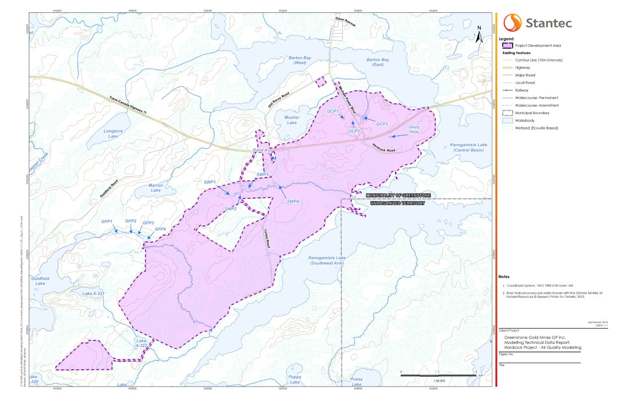
- Figure 1: Project development area
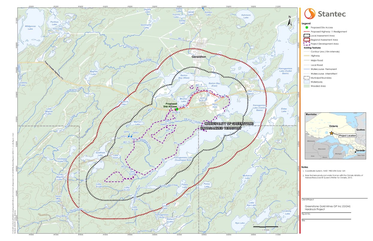
- Figure 2: Local assessment area for air quality, health and socio-economic conditions and current use of lands and resources for traditional purposes by Aboriginal peoples
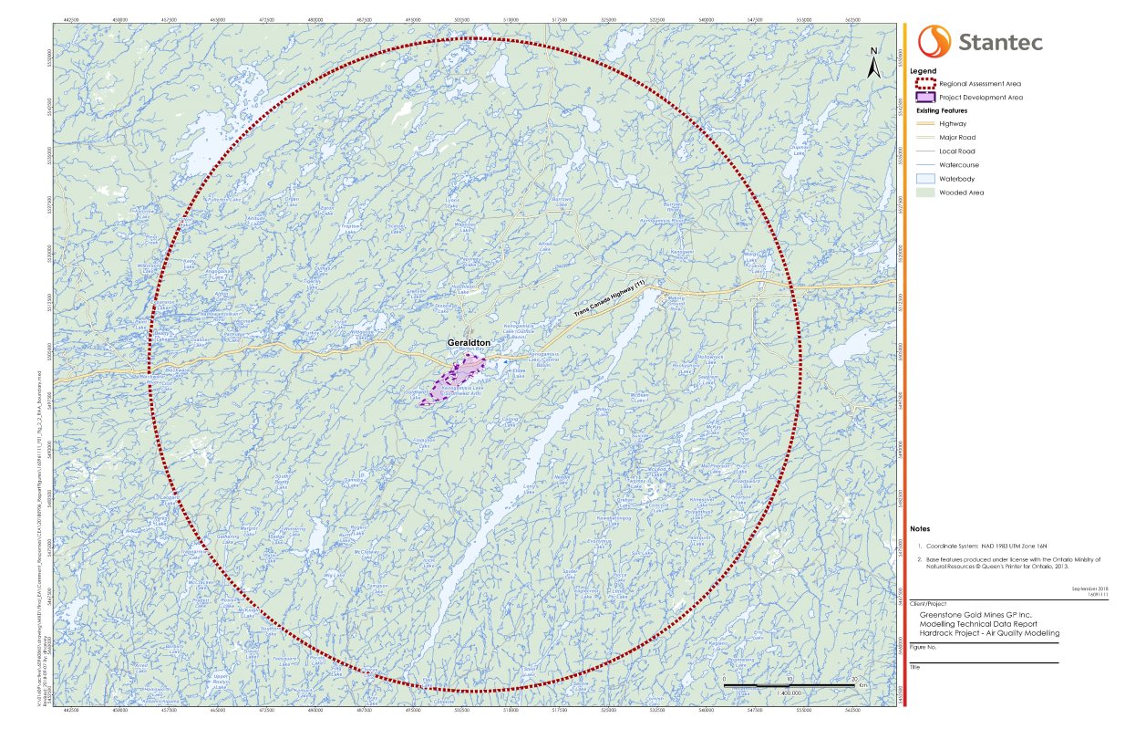
- Figure 3: Regional assessment area for air quality, health and socio-economic conditions and current use of lands and resources for traditional purposes by Aboriginal peoples
- Figure 4: Spatial boundaries for noise and vibration
- Figure 5: Spatial boundaries for vegetation communities and migratory birds
- Figure 6: Spatial boundaries for groundwater
- Figure 7: Spatial boundaries for surface water
- Figure 8: Project location
- Figure 9: Site plan
- Figure 10: Site plan – process plant area details
- Figure 11: Subwatershed map
- Figure 12: Aboriginal community locations
- Figure 13: Locations of proposed removal of waterbodies and watercourses, and of propsoed offset measures
- Figure 14: Past, existing and future physical activities situated near the Project
List of Abbreviations and Acronyms
- CEAA 2012
- Canadian Environmental Assessment Act, 2012
- Indigenous use
- Current use of lands and resources for traditional purposes, as described in paragraph 5(1)(c) of CEAA 2012
- the Agency
- Canadian Environmental Assessment Agency
- the Project
- Hardrock Gold Mine
- the proponent
- Greenstone Gold Mines
- the Report, this Report
- Draft Environmental Assessment Report
- the Minister
- Minister of Environment and Climate Change
Glossary
- Abandonment
- The phase of the Project after decommissioning activities have been completed, including the period during which the open pit is filled with water, and monitoring activities are continued. Referred to as the post-closure phase in the proponent's environmental impact statement.
- Acid rock drainage
- Some rocks, typically those containing an abundance of sulfide minerals, when exposed to water and air can release water which is more acidic than the natural surrounding environment. Often associated with metal leaching.
- Construction
- The phase of the Project during which physical activities are undertaken in connection with vegetation clearing, site preparation, and building or installation of any component of the Project, prior to operations.
- Contact water
- Water which has come into contact with Project components and their associated infrastructure.
- Cyanidation
- A technique for extracting gold from low-grade ore, using a chemical reaction that involves a solution of cyanide.
- Decommissioning
- The phase of the Project after commercial production has permanently ceased, during which project components related to operations are removed and rehabilitation of the mine site begins. Referred to as the active closure phase in the proponent's environmental impact statement.
- Effluent
- Liquid waste flows from project activities or components, including releases from mine operations, tailings management facility, seepage and surface drainage.
- Environmental impact statement
- The document prepared by the proponent that identifies and assesses the environmental effects of the Project, and the measures proposed to mitigate those effects, in accordance with the environmental impact statement guidelines provided by the Agency.
- Environmental impact statement guidelines
- A document prepared by the Agency that identifies the requirements for the preparation of the environmental impact statement. This document specifies the nature, scope and extent of the information required from the proponent for the Project.
- Eutrophication
- Excessive richness of nutrients in a body of water which causes a dense growth of plant life, and death of animal life from lack of oxygen.
- Follow-up program
- A program, whose elements are outlined by the Agency, to verify the accuracy of environmental conclusions and evaluate the effectiveness of mitigation measures.
- Historical tailings
- Tailings that exist from the former MacLeod-Mosher and Hardrock projects, that are located in the northern portion of the project development area.
- Historical underground workings
- Shafts and underground excavations that exist from underground mining activities at the former MacLeod-Mosher and Hardrock mines, that are located in the northern portion of the project development area.
- Local assessment area(s)
- An area studied for each valued component, which correspond to where effects extending outside the project development area are most predicted to occur. Refer also to "regional assessment area".
- Metal leaching
- The release of metals from rocks exposed to water and air, which can increase the concentrations of these metals in contact water. Often associated with acid rock drainage.
- Operations
- The phase of the Project during which commercial production takes place.
- Overburden
- Material overlying the ore deposit, including rock as well as soil and other unconsolidated (loose) materials.
- Particulate matter (PM10)
- Particles with diameters of 10 micrometres or less.
- Fine particulate matter (PM2.5)
- Particles with diameters of 2.5 micrometres or less.
- Pit lake
- Lake that will be created by filling the open pit after operations.
- Process water
- Water that is added to the crushed ore during extraction of gold at the ore processing plant.
- Project development area
- The geographic area overprinted by mining-related project components (i.e., open pit, tailings management facility, waste rock storage areas, ore stockpiles, processing plant). This area covers 2200 hectares (22 square kilometres).
- Regional assessment area(s)
- An area studied for each valued component, to ensure a robust understanding of baseline conditions, capture cumulative effects on a regional scale, and account for geographic extent of potential effects. Refer also to "local assessment area".
- Tailings
- The mixture of ore material, water, and residual chemicals left over after gold is removed from ore in the ore processing plant. Solid material in tailings is usually the size of sand grains or smaller.
- Valued component
- Biophysical or human features of the environment that have importance due to their roles in the ecosystem and the worth people place on them.
- Waste rock
- Rock which does not contain any minerals in sufficient concentration to be considered ore, but which must be removed in the mining process to provide access to the ore.
1 Introduction
1.1 Purpose of the Draft Environmental Assessment Report
The purpose of the draft Environmental Assessment Report (this Report) is to summarize the assessment conducted by the Canadian Environmental Assessment Agency (the Agency), including the information and analysis considered, and the Agency's conclusions on whether the Project is likely to cause significant adverse environmental effects, after taking into account the implementation of mitigation measures. The Minister of Environment and Climate Change (the Minister) will consider this Report and comments received from Indigenous groups and the public in her decision under the Canadian Environmental Assessment Act, 2012 (CEAA 2012) on the significance of any adverse environmental effects of the Project and in establishing conditions for inclusion in her Decision Statement should it be ultimately allowed to proceed.
Greenstone Gold Mines (the proponent) is proposing the construction, operation, decommissioning, and abandonment of the Hardrock Gold Mine Project (the Project), which includes an open pit gold mine and onsite metal mill, located approximately five kilometres south of Geraldton, Ontario, at the intersection of Highway 11 (Trans-Canada Highway) and Michael Power Boulevard. As proposed, the gold mine would have an ore production capacity of 30 000 tonnes per day, and the metal mill would have an ore input capacity of 30 000 tonnes per day.
The proponent is a 50/50 joint venture partnership formed on March 9, 2015 between Premier Gold Mines Inc. and Centerra Gold Inc., for planning, constructing, operating and ultimately decommissioning and abandoning the Project.
1.2 Scope of Environmental Assessment
1.2.1 Environmental assessment requirements
The Project is subject to an environmental assessment by the Agency under CEAA 2012 because it involves activities described in the schedule to the Regulations Designating Physical Activities. Specifically, the Project includes the construction, operation, decommissioning and abandonment of a new gold mine and metal mill. These meet the descriptions and thresholds set out in items 16(b) and 16(c) of the schedule to the Regulations Designating Physical Activities:
- 16(b) the construction, operation, decommissioning, and abandonment of a metal mill with an ore input capacity of 4000 tonnes per day or more; and,
- 16(c) the construction, operation, decommissioning, and abandonment of a rare earth element mine or gold mine, other than a placer mine, with an ore production capacity of 600 tonnes per day or more.
On April 23, 2014, the proponent submitted a project description, upon which the Agency initiated a screening of the Project to determine if an environmental assessment was required. On April 28, 2014, the Agency invited the public and Indigenous groups to provide comments on the summary of the project description. On June 12, 2014, the Agency determined that an environmental assessment of the Project was required, and the environmental assessment was officially initiated on June 13, 2014. On August 5, 2014, the Agency issued the environmental impact statement guidelines to identify the nature, scope and extent of information required from the proponent.
Cooperative environmental assessment requirements
In addition to being subject to an environmental assessment under CEAA 2012, the proponent entered into a voluntary agreement with the Ontario Ministry of the Environment, Conservation and Parks to subject its project to the requirements of Ontario's Environmental Assessment Act and undertook a provincial individual environmental assessment. The proponent conducted environmental studies and sought input from Indigenous groups and the public to address both federal and provincial requirements. The Agency and the Province of Ontario, represented by the Ontario Ministry of the Environment, Conservation and Parks, coordinated to the extent possible the conduct of the federal and provincial environmental assessments to streamline efforts of all parties. This included coordination of public and Indigenous consultation, as well as coordination of the review by federal and provincial technical experts.
1.2.2 Factors considered in the environmental assessment
In consideration of section 19 of CEAA 2012, the following factors were considered in the environmental assessment:
- the environmental effects of the Project, including environmental effects of malfunctions or accidents that may occur in connection with the Project and any cumulative environmental effects that are likely to result from the Project in combination with other physical activities that have been, are or will be carried out;
- the significance of those effects;
- comments from the public;
- mitigation measures that are technically and economically feasible and that would mitigate any significant adverse environmental effects of the Project;
- the requirements of the follow-up program in respect of the Project;
- the purpose of the Project;
- alternative means of carrying out the Project that are technically and economically feasible and the environmental effects of any such alternative means;
- any change to the Project that may be caused by the environment;
- transboundary effects, including in relation to direct greenhouse gas emissions; and
- community knowledge and Indigenous traditional knowledge.
The federal environmental assessment also considered the adverse effects of the project on wildlife species listed in the Species at Risk Act and their critical habitat, as well as effects on species designated by the Committee on the Status of Endangered Wildlife in Canada.
1.2.3 Federal decisions that may be required
Several federal decisions may be required for the Project to proceed (Table 1). Therefore, in accordance with subsection 5(2) of CEAA 2012, the environmental assessment considered:
- changes other than those referred to in paragraphs 5(1)(a) and (b), that may be caused to the environment that are directly linked or necessarily incidental to any federal decisions pursuant to other legislation; and
- effects other than those referred to in paragraph 5(1)(c), of any changes that may be caused to the environment, referred above, on health and socio-economic conditions, physical and cultural heritage, or any structure, site or thing that is of historical, archaeological, paleontological or architectural significance.
|
Potential Federal Decision |
Project Component or Activity related to Decision |
|---|---|
|
Metal and Diamond Mining Effluent Regulations under the Fisheries Act
|
Use of fish-frequented waterbodies for mine waste disposal |
|
Fisheries Act
|
Serious harm to fish (including the death of fish or any permanent alteration to, or destruction of, fish habitat) |
|
Explosives Act
|
Facilities for the manufacture and storage of explosives |
1.2.4 Selection of valued components
Valued components are environmental and socio-economic features of the environment that may be affected by the Project and that have been identified to be of concern by the proponent, government agencies, Indigenous groups or the public. The valued components, selected by the Agency to focus the environmental assessment and the associated analysis, are presented in Table 2.
In accordance with subsection 5(1) of CEAA 2012, the environmental assessment considered the significance of the potential adverse environmental effects on environmental components that are within federal jurisdiction, including:
- effects on fish and fish habitat;
- effects on migratory birds;
- transboundary effects; and
- effects on Aboriginal peoples of any change that may be caused to the environment on the current use of lands and resources for traditional purposes, health and socio-economic conditions, physical and cultural heritage, or any structure, site or thing that is of historical, archaeological, paleontological or architectural significance.
|
Valued Component |
Rationale |
|---|---|
|
Effects identified pursuant to subsection 5(1) of CEAA 2012 |
|
|
Fish and fish habitat |
Project-related changes in water quantity and quality, noise, and vibration may affect fish and fish habitat. |
|
Migratory birds |
Project-related changes in noise levels, and the disturbance of terrestrial, aquatic and wetland habitat may affect migratory bird mortality and behaviour. |
|
Health and socio-economic conditions of Aboriginal peoples |
Project-related changes to the atmospheric, terrestrial, and aquatic environments, and changes to country foods may affect the health and socio-economic conditions of Aboriginal peoples. |
|
Current use of lands and resources for traditional purposes by Aboriginal peoples |
Project-related changes to the atmospheric, aquatic and terrestrial environments may affect the use of lands and resources for traditional purposes by Aboriginal peoples. |
|
Physical and cultural heritage, and any structure, site or thing that is of historical, archaeological, paleontological or architectural significance for Aboriginal peoples |
Project-related changes to the terrestrial and atmospheric environments and changes in access to lands may affect physical and cultural resources of Aboriginal peoples or historical or archaeological sites or structures. |
|
Transboundary environment |
Project-related emissions of greenhouse gases may contribute to climate change. |
|
Effects identified pursuant to subsection 5(2) of CEAA 2012 |
|
|
Wetlands |
Project-related changes to water quantity and disturbance of terrestrial habitat which could adversely affect wetlands, which play an important ecosystem function, and are difficult to restore. |
|
Effects identified pursuant to subsection 79(2) of theSpecies at Risk Act |
|
|
Species at risk |
Project-related disturbance of terrestrial and aquatic environments could affect species at risk and their critical habitat. |
1.2.5 Spatial and temporal boundaries
The proponent has proposed spatial and temporal boundaries, to define the areas and timeframes within which the Project may interact with the environment and cause environmental effects. Several spatial boundaries are considered in the Report:
- Project development area: The geographic area overprinted by mining-related project components (i.e., open pit, tailings management facility, waste rock storages area, ore stockpiles, processing plant). This area covers 2200 hectares (22 square kilometres).
- Local assessment areas: Areas studied for each valued component, which correspond to where effects extending outside the project development area are most predicted to occur.
- Regional assessment areas: Areas studied for each environmental discipline, to ensure a robust understanding of baseline conditions, capture cumulative effects on a regional scale, and account for geographic extent of potential effects.
The Agency reviewed the proponent's study areas and identified consistent with the valued components to be assessed for CEAA 2012. These areas are described in Table 3. The project development area is shown as the purple area in Figure 1.
|
Valued Component |
Local assessment area |
Regional assessment area |
|---|---|---|
|
Health and socio-economic conditions of Aboriginal peoples, current use of lands and resources for traditional purposes by Aboriginal peoples This encompasses the areas for air quality (Figure 2 and Figure 3), noise and vibration (Figure 4) and vegetation communities (Figure 5) |
A rectangle of 27 kilometres x 28 kilometres centered on the project development area. (Figure 2) |
A circle with a 50-kilometre radius, centered on the project development area. (Figure 3) |
|
Fish and fish habitat This encompasses the areas for groundwater (Figure 6) and surface water (Figure 7) |
Kenogamisis Lake, creeks, and watercourses that flow into the northwest side of the Southwest Arm of Kenogamisis Lake (including Goldfield Creek and its tributaries), Goldfield Lake, Marron Lake, Mosher Lake, Lake A-320, Lake A-321, Begooch Zaagi'igan (Lake A-322), and Lake A-323. |
The upstream drainage area of Barton Bay and the upstream drainage area of the Southwest Arm of Kenogamisis Lake. This includes all of Kenogamisis Lake, and extends downstream along the Kenogamisis River to the reservoir created by the Kenogami Control Dam, and southward along the Kenogamisis River to Crib Road. |
|
Migratory birds |
0.5 kilometres from the boundaries of the project development area. |
Burrows River, Kenogamisis River and Kenogamisis Lake watersheds. |
|
Physical and cultural heritage, and any structure, site or thing that is of historical, archaeological, paleontological or architectural significance for Aboriginal peoples |
0.8 kilometres from the boundaries of the project development area. |
Burrows River, Kenogamisis River and Kenogamisis Lake watersheds. |
|
Transboundary environment – greenhouse gas emissions |
A rectangle of 27 kilometres x 28 kilometres centered on the project development area. |
Global. |
|
Wetlands (Effects identified pursuant to subsection 5(2) of CEAA 2012) This encompasses the areas for vegetation communities (Figure 5) |
The combination of: the area extending 30 metres from the boundaries of the project development area; the area where groundwater drawdown is predicted to be 0.5 metres or greater, and the areas where surface water flow is predicted to change as a result of drainage alterations in the project development area during Project construction. |
Burrows River, Kenogamisis River and Kenogamisis Lake watersheds. |
Temporal boundaries identify when an effect may occur in relation to specific project activities. Generally, these boundaries are based on a single project phase, or a combination of phases, to reflect the duration of project activities that are likely to cause adverse environmental effects on valued components. The Project has four phases:
- Construction (3 years): When physical activities are undertaken in connection with vegetation clearing, site preparation, and building or installing any component of the Project, prior to operations.
- Operations (15 years): When commercial production takes place.
- Decommissioning (approximately 5 years): After commercial production has permanently ceased, when project components related to operations are removed and rehabilitation of the project development area begins.
- Abandonment (approximately 16 years): After decommissioning activities have been completed, including the period during which the open pit is filled with water, and monitoring activities are continued.
Source: Stantec, September 2018

Source: Stantec, September 2018
Source: Stantec, September 2018
Source: Stantec, September 2018

Source: Stantec, September 2018
Source: Stantec, September 2018

Source: Stantec, September 2018
1.2.6 Methods and approach
The Agency reviewed various sources of information in conducting its analysis, including:
- the environmental impact statement submitted by the proponent in July 2017;
- additional information provided by the proponent during the course of the environmental assessment in the form of responses to information requirements issued by the Agency during its review of the environmental impact statement;
- advice from government reviewers; and
- comments received from the public and Indigenous groups.
The Agency assessed the significance of adverse effects on each valued component, following the application of mitigation measures, in accordance with the Agency's Operational Policy Statement Determining Whether a Designated Project is Likely to Cause Significant Adverse Environmental Effects under the Canadian Environmental Assessment Act, 2012 Footnote 1. The Agency characterized the residual adverse effects on valued components by using the following assessment criteria:
- Magnitude: Severity of the adverse effect
- Geographic extent: Spatial reach of the adverse effect
- Duration: Length of time that a valued component would be affected by the adverse effect
- Timing: Applied to a valued component when relevant (e.g., species breeding season, Indigenous spiritual and cultural practices)
- Frequency: Rate of recurrence of the adverse effect
- Reversibility: Degree to which the environmental conditions can recover after the adverse effect occurs
The Agency also considered ecological and social context for all valued components and across all the criteria listed above. Context refers generally to the current state of the valued component and its sensitivity and resilience to the change caused by the Project.
Appendix A (Table 12 and Table 13) provides the definitions and limits used to assign the level of effect for each rating criterion. The Agency used a grid (Table 14) which combines the predicted degree of effect after considering the mitigation measures to determine the significance of the residual effects on the valued components. Appendix B summarizes the residual effects assessment for all valued components during all phases of the Project. The Agency's analysis and conclusions on the significance of adverse environmental effects are presented in Chapter 7.
The proponent's environmental impact statement addresses effects to valued components in areas of federal jurisdiction, as highlighted in Section 1.2.4, as well as other valued components, such as labour and economy, community services and heritage resources, and impacts to MacLeod Provincial Park.
2 Project Overview
2.1 Project Location
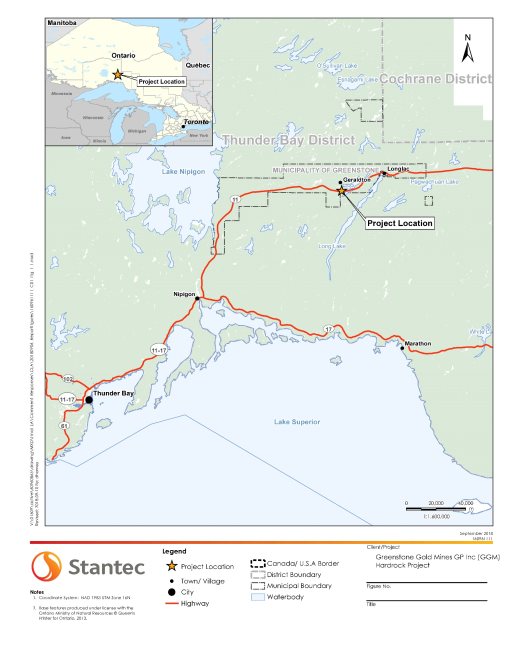
The Project is located in the Municipality of Greenstone, in northern Ontario (Figure 8), approximately five kilometres south of the Ward of Geraldton, along Highway 11 (the Trans-Canada Highway). It is located approximately 275 kilometres northeast of Thunder Bay. The Project is located within the Treaty 9 area of Ontario, also known as the James Bay Treaty of 1905-1906.
Source: Stantec, September 2018
2.2 Project Components
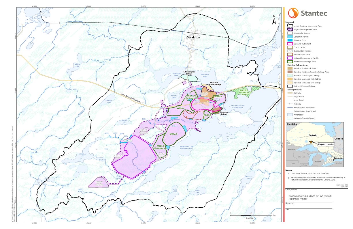
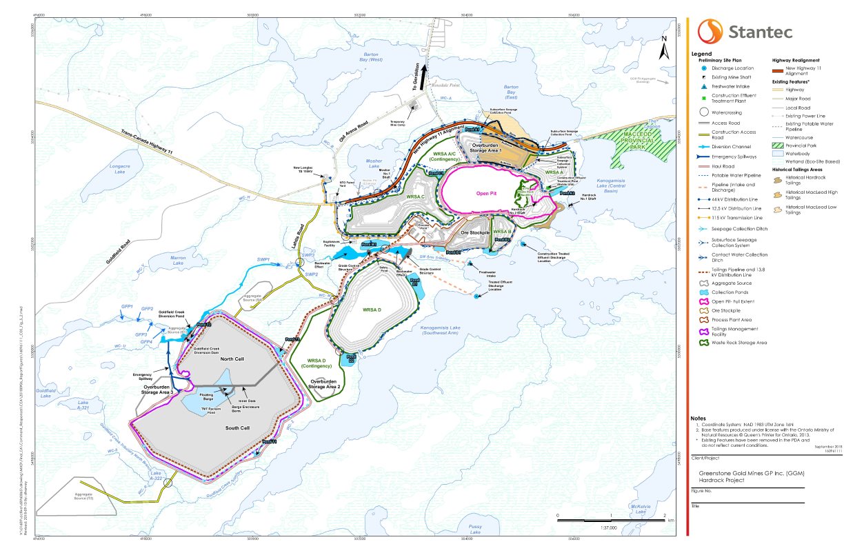
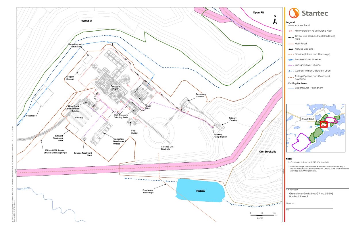
The Project as proposed includes the following components, as depicted in the site plan in Figure 9, and in the detailed plan around the process plant in Figure 10.
- Open pit: The open pit would be approximately 168 hectares (2100 metres in length and 800 metres in width) in area, and 570 metres in depth. In-pit backfilling would occur at the eastern extension of the open pit during Years 6 and 7 of operations. At the end of operations, the overall dimensions of the open pit would be reduced to approximately 120 hectares (1500 metres in length and 800 metres in width) in area, and 570 metres in depth.
- Tailings management facility: Approximately 140 million tonnes of tailings would be stored in two adjacent (north and south) cells, located four kilometres to the southwest of the process plant, and covering approximately 518 hectares in area. The ultimate dam height would be approximately 35 metres. Tailings from the process plant would be pumped via a reclaim pipeline from the process plant to the facility.
- Waste rock storage areas (A, B, C and D): Approximately 530.8 million tonnes of waste rock would be generated, with most of it stockpiled in three waste rock storage areas (named A, B, and C) around the open pit, and in waste rock storage area D to the south of Southwest Arm Tributary. These four areas would occupy 421 hectares, and range in elevation from 65 to 100 metres. Approximately 73.5 million tonnes of waste rock would be stored inside the east portion of the open pit, as an extension to waste rock storage area A. Two contingency waste rock storage areas are proposed, one between waste rock storage areas A and C, and the other between the tailings management facility and waste rock storage area D.
- Topsoil and overburden storage areas: Overburden and topsoil that is removed would be stockpiled north of the open pit, with additional temporary storage areas in the contingency area for waste rock storage area D, and adjacent to the tailings management facility.
- Ore stockpile: An ore stockpile would be built south of the open pit, connected to the crushing plant, with a capacity of approximately 33.6 million tonnes. Ore stockpiling would start during construction, before the mill is commissioned.
- Crushing plants and mill feed ore storage area: Components used for crushing the extracted ore would be located between the process plant and the ore stockpile. Crushing would occur with a primary gyratory crusher and a secondary cone crusher. The crushed ore would be held in the mill feed ore storage area, with a capacity of approximately 27.5 million tonnes, prior to its processing.
- Process plant: Gold recovery would occur using a combination of gravity separation and cyanidation. In-plant cyanide detoxification would consist of sulphur dioxide and air. The process plant would be located southwest of the open pit.
- Goldfield Creek diversion channel: The Goldfield Creek diversion channel would address the overprinting of Goldfield Creek and other smaller waterbodies. The proposed Goldfield Creek diversion channel includes the 7.5-hectare Goldfield Creek diversion pond, at the interface between the existing Goldfield Creek and the new diversion channel; a new 2.7-kilometre Goldfield Creek between the Goldfield Creek Diversion Pond and the existing Southwest Arm Tributary watercourse SWP1; reconstruction of the existing Southwest Arm Tributary channel between SWP2 and SWP3 to convey larger flows and facilitate the replacement of the existing Lahtis Road crossing; and construction of two grade-control structures within the existing Southwest Arm Tributary to impound and attenuate flows.
- Water management facilities: The process plant area, mill feed ore storage area, overburden storage area, and waste rock storage areas would be drained by a series of contact water collection ditches that would collect runoff and seepage water and direct it to a series of collection ponds. Water would be pumped from the collection ponds, and from dewatering of the historical underground workings and the open pit, into pond M1. The tailings management facility would include an integrated seepage collection system to capture runoff and seepage, which would be pumped back to the tailings management facility. Recycled water would be drawn from the tailings management facility reclaim pond and pond M1 for most processes via pipelines; those that demand process water would be drawn from effluent from the effluent treatment plant, or from Kenogamisis Lake via an intake pipe located in the Southwest Arm in the event water from the effluent treatment plant is not suitable for this use.
- Effluent treatment plants: There would be two, a mobile one used during construction to facilitate dewatering of historical tailings and a static one located near the process plant. During construction, the mobile effluent treatment plant would be placed in proximity to construction earthworks. This plant would treat effluent from dewatering of the historical underground workings, seepage and surface water runoff from the historical tailings, and surface water runoff from the process plant area. The location of the mobile plant can change based on the needs of the Project. During operations, excess water from pond M1 would be sent to the static effluent treatment plant, located near the process plant, for metals removal and reduction of total suspended solids prior to discharge to the Southwest Arm of Kenogamisis Lake.
- Onsite Pipelines: Water, tailings and natural gas pipelines would be required throughout the project development area. Water pipelines would be above ground except where pipelines cross roadways, and portions of the tailings management facility pipeline. Pipelines are described with the project components that they serve.
- Watercourse crossings: Watercourse crossings would be required for the construction of the access road, haul road, tailings management facility reclaim pipeline, transmission line realignment, and the distribution line realignment.
- Site roads: Onsite roads include the access road, haul roads, construction access roads, and other smaller roads around waste rock storage areas.
- Highway 11 and Patrol Yard: The realignment of a portion of Highway 11 is required to accommodate the open pit and other project components. Highway 11 would be realigned to the north of the project development area, and a new intersection with Michael Power Boulevard would provide access to Geraldton, requiring approximately 600 metres of Michael Power Boulevard to be realigned. The realigned highway would traverse approximately 1.2 kilometres of the historical MacLeod tailings (Figure 9). After construction, the operation and maintenance of the new Highway 11 would be the responsibility of the Ontario Ministry of Transportation. The existing Ontario Ministry of Transportation Patrol Yard would be relocated to the west of waste rock storage area C.
- Hydro One Transformer Station, transmission and distribution lines: The existing Longlac Transformer Station and associated service station would be relocated approximately two kilometres west of its current location, along with the incoming transmission line and the outgoing distribution lines. A new access road connecting to Highway 11 would be constructed to provide access to the relocated Longlac Transformer Station. After construction, the operation and maintenance of the access road would be the responsibility of Hydro One.
- Aggregate sources: In addition to waste rock from the open pit, a combination of local existing and new aggregate sources would be used to supply the construction needs of the Project. Aggregate sources S1 and S4 would be to the north of the tailings management facility, while aggregate source T2 to the southwest would be used to supply till that is acceptable for use in construction of the tailings management facility dams.
- Service water supply and associated infrastructure: The project development area, including the temporary camp would connect to the municipal water system to provide potable water and service water to the buildings. The historical underground workings or treated effluent would provide water for firefighting, to be stored in a dedicated tank in the project development area.
- Temporary camp: A temporary modular camp would be constructed on the south side of Old Arena Road, west of the intersection with Michael Power Boulevard, to house construction workers during construction and early operation when some construction activities may be ongoing. Occupancy would vary over time with an anticipated average of 450 beds up to approximately 600 beds during peak construction.
- Sewage treatment: A third-party sewage disposal contractor would provide portable washroom facilities during early construction, until the sewage treatment plant and effluent discharge pipeline are operational. During operations, a package modular sewage treatment plant would be constructed near the process plant to service the mine offices, mine dry building and process plant. If required, portable washroom facilities would also be used at the temporary camp during construction.
- Power supply and associated infrastructure: Power for construction would be from a temporary grid connection via the local distribution system that currently services the Geraldton area. Power for operations would be generated onsite by a natural gas-fueled power plant. A small plant to generate liquefied natural gas would be installed close to a natural gas distribution line for ease of connection. Prior to opening the plant, liquefied natural gas could be trucked to the Project on an as-needed basis from the closest commercial liquefied natural gas source, in Hagar, Ontario.
- Explosives facility: Explosives would be prepared and stored in a dedicated explosives manufacturing facility, either located off the haul road or off the site access road.
- Fuel and hazardous materials transportation and storage: The fuel station, for fueling of heavy equipment and vehicles, would be located near the process plant. There would be six double-walled above-ground diesel storage tanks, a liquid urea storage tank, and a gasoline storage tank. Mill reagents would be stored onsite in a concrete containment area near the process plant.
- Buildings: Buildings, located near the process plant to the southwest of the open pit, would include a mine dry and administration building, a truck shop, warehouse, offices, and a recycling and sort facility.
Source: Stantec, September 2018
Source: Stantec, September 2018
2.3 Project Activities and Schedule
The proponent anticipates the following phases for the Project:
- Construction: Year -3 to Year -1;
- Operations: Year 1 to Year 15 (with gradual ramp-up through Years 1 and 2, and full operations in Years 3 to 15);
- Decommissioning: Year 16 to Year 20.
- Abandonment: Year 21 to Year 36.
Construction would be able to commence once the federal and provincial environmental assessment processes are complete and the proponent has been issued all applicable approvals and permits.
2.3.1 Construction
Construction activities would occur primarily during daytime hours. Project activities during construction would include the following:
- realignment of Highway 11;
- excavation of portions of the historical MacLeod tailings (located within the footprint of the open pit) and the historical Hardrock tailings (up to the 30-metre setback from the high-water mark of Kenogamisis Lake), to be stored temporarily in waste rock storage area C and near the historical MacLeod tailings;
- relocation of the Hydro One transformer station, transmission and distribution lines;
- site preparation, including progressive removal of existing infrastructure, timber harvesting, clearing and grubbing, soil stripping, grading, blasting, and leveling of the project development area, and removal of topsoil and overburden;
- implementation of the construction effluent treatment plant to discharge effluent into the Southwest Arm of Kenogamisis Lake;
- construction and implementation of the water management facilities, watercourse crossings and Goldfield Creek diversion channel;
- construction of buildings and installation of equipment associated with mine operations;
- extraction from aggregate sources;
- construction of linear facilities (e.g., roads, onsite pipelines and piping, transmission and distribution lines and substation) and ancillary facilities (e.g., fuel supply, and storage and distribution);
- initial development of open pit and initial stockpiling of ore; and
- construction of the process plant near the end of the construction phase.
2.3.2 Operations
Operations activities would occur 24 hours per day, 365 days per year. Project activities during operations would include the following:
- construction and operation of the open pit, including drilling, blasting, loading and hauling of ore and waste rock to designated areas;
- devegetation, clearing, overburden stripping and hauling of waste rock to designated areas, progressively, as the open pit expands;
- ore milling and ore processing, with gold doré bars produced at the end of the process; this would occur in two phases: Phase 1 (Years 1 and 2) with a production rate up to 24 000 tonnes per day of ore, and Phase 2 (Years 3 to 15) would progressively increase production up to 30 000 tonnes per day;
- tailings pumping from the process plant to the tailings management facility;
- placement of excavated portions of historical tailings in the new tailings management facility in Years 2 to 4 of operation, after a two-metre layer of new tailings has been laid; and
- revegetation, as possible, of areas of the tailings management facility and waste rock storage areas.
2.3.3 Decommissioning
After operations, the project development area would be rehabilitated, and the Project would progress toward abandonment. Project activities during decommissioning would occur mainly in the first five years following completion of operations, and would include the following:
- removal of buildings and project components, including pipelines, access roads, culverts and power lines, as they are no longer required to support monitoring or filling of the open pit;
- construction of a boulder fence or appropriate berm around the perimeter of the open pit, to prevent inadvertent access to the open pit;
- covering and revegetation of the top of the waste rock storage areas and of the surface of the tailings management facility to enhance aesthetics, reduce the potential for surface erosion, and reduce water infiltration;
- revegetation of other disturbed areas in the project development area with non-invasive species to promote the development of natural revegetation;
- filling of the open pit, by pumping water from the tailings management facility, contact water collection ponds, and the historical underground workings to form a dense layer of water at the bottom of the open pit, followed by freshwater from the Southwest Arm of Kenogamisis Lake to promote the development of an upper layer of freshwater; and
- monitoring and maintenance activities would be carried out throughout decommissioning.
2.3.4 Abandonment
After decommissioning, the Project would continue to be monitored while the open pit is allowed to fill with water, creating a pit lake. The proponent estimates that water quality in the pit lake would meet water quality standards approximately five years after it is formed. Most access restrictions will be lifted after decommissioning; however, a boulder fence will be maintained around the open pit for safety purposes. Project activities during abandonment would include the following:
- continued filling of the open pit mainly from the Southwest Arm of Kenogamisis Lake, until the water level reaches approximately 331.0 metres elevation; the open pit is anticipated to take approximately 16 years to fill from the beginning of decommissioning, ending at approximately Year 11 of abandonment;
- construction of a channel to connect the southeastern portion of the filled pit lake to the Southwest Arm of Kenogamisis Lake; and
- ongoing monitoring of effluent water quality and of physical stability of embankment and open pit slopes until water quality in the pit lake has been demonstrated to meet provincial water quality standards.
3 Purpose of Project and Alternative Means
3.1 Purpose of Project
The purpose of the Project is to extract gold from a former brownfield site (formerly the MacLeod-Mosher complex), to be sold on the market. The proponent anticipates that the Project would provide a reasonable rate of return on investment to shareholders, and bring benefits to the local economy and region, such as increased local and regional revenues and business profits from which future investments in social services, community infrastructure, business development and capacity building.
3.2 Alternative Means of Carrying Out the Project
CEAA 2012 requires that every environmental assessment of a designated project take into account the alternative means of carrying out the project that are technically and economically feasible, and consider the environmental effects of any such alternative means. The Agency's Operational Policy Statement Addressing "Purpose of" and "Alternative Means" under the Canadian Environmental Assessment Act, 2012 Footnote 2 sets out the general requirements and approach to address the alternative means of carrying out the designated project under CEAA 2012. The proponent identified technically and economically feasible alternatives for major project components, their environmental effects and the rationale for selecting the preferred option. The most critical project components are considered in this chapter.
The proponent has stated that the nature of the deposit makes open-pit mining the only economically viable mining method, and it did not conduct an in-depth analysis on the feasibility of other methods.
3.2.1 Alternatives Assessment
Tailings management facility and tailings disposal
The proponent considered various combinations of tailings management facility locations, disposal methods, and dam construction methods. Four potential locations were identified for the tailings management facility as noted below. A location to the southwest of the open pit, and to the northwest of the Southwest Arm of Kenogamisis Lake, was selected as the preferred alternative, with conventional impoundment disposal and downstream dam construction. This approach would result in the loss of the least amount of forested land (as associated habitat), and less habitat fragmentation due to haul road and pipeline construction. However, it will result in the loss of wetland habitat and the overprinting of Goldfield Creek. It would leave a relatively small amount of exposed tailings, which would require less cover placement after operations. It would be in relatively close proximity to the open pit, thus generating less dust due to hauling and wind-blown tailings. It would provide lower risk of seepage and leakage due to relatively short pipeline length. The foundation material would be anticipated to resist seepage, and the natural topography would limit dam height and length.
- southwest of the open pit to the northwest of the Southwest Arm of Kenogamisis Lake;
- southwest of the open pit on a relative topographical high overlooking Goldfield Lake;
- west of the open pit to the southeast of Wildgoose Lake; and
- southwest of the open pit, to the southwest of the Southwest Arm of Kenogamisis Lake in an area surrounded by waterbodies and watercourses.
Two alternatives were considered for closing the tailings management facility, while ensuring long term physical stability of tailings dams and other containment structures as well as effluent quality: cover and vegetate, or water cover. Water cover would involve flooding the tailings management facility to maintain tailings in a saturated state, and would require taller and more reinforced dams, ongoing maintenance and monitoring of water quality and dam stability. The preferred alternative is to cover the tailings management facility with low permeability material, followed by vegetation with native plant species. This alternative would have reduced costs, reduced infiltration of precipitation through the tailings, and reduced dust generation. Furthermore, the vegetation will provide terrestrial habitat for fauna.
Waste rock disposal, and waste rock storage areas
Four potential waste rock disposal methods were identified as noted below. A combination of above-ground and in-pit storage of non-segregated waste rock was selected as the only economically and technically feasible alternative for waste rock disposal. A portion of the waste rock would be stored in the eastern portion of the open pit, with sufficient land available to stockpile the remainder of the waste rock in a reliable manner. This option is also minimizes environmental effects while reducing the footprint of the Project.
- Combination of above-ground and in-pit storage of non-segregated waste rock;
- Storage of all waste rock in the open pit;
- Co-disposal of waste rock and tailings; and
- Segregation of waste rock due to acid rock draining/metal leaching potential.
Four potential arrangements of the waste rock storage areas were considered that met the same preliminary criteria described for the tailings management facility. All candidate arrangements involved three storage areas surrounding the open pit, and a fourth storage area located south of the open pit. The preferred arrangement, while located farther from the open pit would overprint a relatively small extent of forested land, less area used for traditional land and resource purposes, shorter lengths of waterbodies, the least extent of wetlands, and would not require a stream diversion.
Highway 11 realignment
Four potential routes were identified by the proponent that met adequate separation distances from the open pit and Kenogamisis Lake. The selected alignment provided an optimal and safer curve between Mosher Lake and Michael Power Boulevard, providing a straighter intersection to Michael Power Boulevard. The safety considerations and technical feasibility of this alternative outweighed the slightly larger loss of wetland and wildlife habitat for the other potential routes.
Process plant location, gold recovery and process water supply
The only feasible alternative identified for the process plant location was onsite, since an offsite location would not be technically or economically feasible. Its location to the west of the open pit was selected for operational efficiency and compatibility with other facilities.
Three methods for gold recovery were considered: cyanidation, flotation recovery and gravity separation. The preferred alternative was a combination of gravity separation (effective at recovering five to 35 percent of gold) and cyanide recovery (the most effective at recovering gold and the industry standard), as it was found to be most effective, while limiting the amount of cyanide used and its potential environmental effects.
Three process water supply sources were considered: reclaim water recycling from the tailings management facility and contact water collection system, water taking from historical underground workings, and freshwater taking from Kenogamisis Lake. The preferred alternative includes recycled reclaim water as a primary water source, while also directing groundwater inflows from the open pit, along with precipitation and surface water runoff, to the historical underground workings as a storage reservoir for secondary water needs. Small volumes of freshwater would also be drawn from the Southwest Arm of Kenogamisis Lake for process steps where reclaim water would be inappropriate.
Ore stockpile, crushing plant and mill feed ore storage area
The only technically and economically feasible alternative identified for the ore stockpile, crushing plant and mill feed ore storage area was onsite near the process plant. Transporting material offsite for temporary storage and crushing would be inefficient and cost prohibitive, with greater dust and greenhouse gas emissions. Its location to the west of the open pit was selected for operational efficiency and compatibility with other onsite facilities.
Goldfield Creek diversion channel
Several options for the Goldfield Creek diversion channel were considered, including an option to the northeast of the tailings management facility. This option was considered preferable as it would require less alterations to existing channels, and less removal of wildlife habitat..
Historical tailings and other contaminated soils
Given the location of the open pit and the realigned highway 11, there is a need to relocate tailings from historical mining activities associated with the MacLeod and Hardrock mines. The removal of all of the historical MacLeod and Hardrock tailings within the project development area to the new tailings management facility was not considered economically feasible due to the volume of material and the timing of project activities, particularly since the realignment of Highway 11 would have to be completed prior to construction of the new tailings management facility. Removal of portions of the tailings within the project development area, with disposal into the new tailings management facility, was considered the only economical alternative to manage the area to be disturbed. The proponent viewed this alternative as providing a net positive impact on Kenogamisis Lake, by reducing metal loadings (primarily arsenic) from historical sources to Kenogamisis Lake.
Contact water collection, treatment and discharge
Standard practice for managing contact water in the open pit (groundwater inflow, precipitation, and runoff) would be to pump the contact water directly to surface ponds for treatment. The Project provides an additional technically feasible alternative, as open pit contact water can be directed to the historical underground workings through drainage shafts bored through the open pit floor. This was chosen as the preferred alternative, as it provides a benefit of using the historical underground workings for temporary storage of water during periods of peak precipitation and runoff. Excess water in the historical underground workings would be sent directly to the effluent treatment plant, or discharged to pond M1 and then to the receiving environment.
For contact water at other Project components (including the waste rock storage areas, overburden storage areas, process plant and ore stockpile), the only technically and economically feasible alternative was to direct contact water to local surface ponds, and then through an effluent treatment plant.
A single treated effluent discharge location was preferred as more economically feasible and simpler than using multiple locations. Potential locations for treated effluent discharge included Southwest Arm Tributary, Mosher Lake, Barton Bay, Southwest Arm of Kenogamisis Lake, and Central Basin of Kenogamisis Lake. In consideration of proximity to shore, water depth, flow pattern, and avoidance of sensitive fish spawning and feeding areas, the preferred location was determined to be in the Southwest Arm of Kenogamisis Lake, south of the mouth of the Southwest Arm Tributary, approximately 100 metres offshore. Potential effects on traditional land and resource use were considered for the various locations. This consideration was not a determining factor as potential impacts were identified at all locations.
Power source and associated infrastructure
Although a distribution line currently runs through the project development area, connection to the existing transmission system would not be technically feasible as the system would not have the capacity to provide all power required for the Project during operations. The establishment of a natural gas-fuelled power plant was identified as the only feasible alternative for a primary power source for the Project. Natural gas would be provided via a short new distribution pipeline operated by Union Gas.
Two options were considered for the power source prior to the natural gas-fuelled power plant being online, during construction and beginning of operations. Temporary diesel generators would provide reliable and flexible onsite power, but would not be economically and technically feasible as a primary energy source due to increased atmospheric emissions, including greenhouse gas emissions, and increased costs for construction and for fuel. The existing distribution line would have enough capacity for initial activities. While it may be susceptible to outages from severe weather events, it would allow for reduced costs and limited environmental effects. The proponent determined that a combination of the two options would be the most reliable alternative for temporary and backup power for the Project.
Filling of the open pit after operations
Three alternatives were considered for filling of the open pit after operations: natural filling with water, enhanced filling with water, and backfill with waste rock. Enhanced filling was selected as the preferred alternative because it would reduce the time until the open pit is filled (approximately 16 years, versus approximately 147 years for natural filling). Enhanced filling would add contact water from the Project, recycled water from the Tailings Management Facility and Pond M1, and freshwater from the Southwest Arm of Kenogamisis Lake. This option would minimize changes to water quality by reducing metal leaching and acid generating conditions in the open pit, and would also allow for earlier wildlife access to the rehabilitated habitat. Water taking from the Southwest Arm of Kenogamisis Lake would not be expected to affect overall lake water levels.
Agency Analysis and Conclusion
The proponent's alternatives assessment considered the cost-effectiveness, technical applicability, reliability, environmental effects, and feedback from Indigenous groups on the selected alternative means of carrying out the Project. Based on its review of this analysis, the Agency is satisfied that the proponent has sufficiently assessed alternative means of carrying out the Project for the purposes of assessing the environmental effects of the Project under CEAA 2012.
4 Consultation Activities and Advice Received
Comments from Indigenous groups and public participants during the environmental assessment were considered by the Agency in its analysis and conclusions regarding the Project. Local and traditional knowledge about the Project location was also considered in identifying potential environmental effects.
Advice received from federal authorities and key information shared between the Agency and the province of Ontario further informed and supported the Agency's review of the Project. As the Agency and the province of Ontario conducted the federal and provincial environmental assessments cooperatively, to the extent possible, the governments also held joint meetings with some Indigenous groups and shared key information received from public and Indigenous participants throughout the concurrent processes.
The Agency provided three previous opportunities for the public, Indigenous groups, and government reviewers to participate in the environmental assessment process. Notices of these opportunities to participate were posted on the Canadian Environmental Assessment Registry's Internet Site. During these opportunities, comments were solicited on:
- whether an environmental assessment is required (April 28, 2014 to May 20, 2014),
- the draft environmental impact statement guidelines (June 13, 2014 to July 13, 2014), and
- the proponent's environmental impact statement (August 21, 2017 to October 6, 2017).
A fourth and final opportunity commenced on October 2, 2018 and the Agency is seeking comments on this report and potential conditions to support the Minister's Decision Statement. This report includes the Agency's conclusions and recommendations. After taking into consideration the comments received from the public, Indigenous groups and government reviewers, the Agency will finalize and submit the Environmental Assessment Report to the federal Minister of Environment and Climate Change for a decision on the Project.
4.1 Public Participation
4.1.1 Public participation led by the Agency
During the environmental impact statement review period, the Agency participated in public open houses with the proponent and representatives from federal authorities and provincial ministries. These public open houses were held in Longlac and in Geraldton on September 13, 2017, and in Thunder Bay on September 16, 2017. These sessions provided opportunities for members of the public to learn and provide comments about the environmental assessment process, the Project and the proponent's environmental impact statement. The Agency also received letters from several business groups in Northwestern Ontario expressing their support for the Project.
4.1.2 Public participation led by the proponent
The proponent engaged residents from the municipality of Greenstone (Geraldton, Longlac, Beardmore and Nakina) and the city of Thunder Bay on the Project, its potential effects and possible mitigation measures. In addition, the proponent consulted other potentially affected or interested stakeholders including local land users, business and community organizations and government agencies.
Public consultation and engagement activities by the proponent included holding meetings, hosting open houses, conducting site visits and developing and issuing plain language materials (e.g., fact sheets and newsletters) to share information and receive feedback about the Project.
4.2 Crown consultation and engagement with Indigenous groups
4.2.1 Crown consultation led by the Agency
The Crown has a duty to consult Indigenous groups, and, where appropriate, to accommodate, when its proposed conduct might adversely impact Aboriginal and treaty rights protected in section 35 of the Constitution Act, 1982 Footnote 3. Crown consultation is also undertaken more broadly as an important part of good governance, sound policy development and appropriate decision making.
For the purposes of the federal environmental assessment, the Agency served as Crown Consultation Coordinator to facilitate a whole-of-government approach to consultation. Indigenous groups that were invited to participate in consultations included those identified as having an interest in the project by reason of the potential for the Project to adversely impact Aboriginal and treaty rights.
In order to fulfill the Crown consultation obligations, the Agency conducted Indigenous consultation in an integrated manner with the environmental assessment process. The Agency provided opportunities throughout the environmental assessment for dialogue with Indigenous groups about their concerns through phone calls, correspondence, and meetings. The Agency provided regular updates to the Indigenous groups to keep them informed of key developments and to solicit feedback. In addition, the groups were invited to participate in the four formal consultation opportunities noted above.
The Agency administers funding from its Participant Funding Program to support Indigenous groups' participation in the environmental assessment process. In total, the Agency allocated $363,617.00, as shown in Table 4, to support the participation of eleven Indigenous groups in the environmental assessment.
|
Indigenous group |
Amount allocated |
|---|---|
|
Animbiigoo Zaagi'igan Anishinaabek |
$62,350.00 |
|
Aroland First Nation |
$62,150.00 |
|
Biigtigong Nishnaabeg |
$9,600.00 |
|
Constance Lake First Nation |
$10,497.00 |
|
Eabametoong First Nation |
$10,500.00 |
|
Ginoogaming First Nation |
$62,295.00 |
|
Long Lake #58 First Nation |
$62,350.00 |
|
Marten Falls First Nation |
$10,500.00 |
|
Métis Nation of Ontario |
$52,375.00 |
|
Pays Plat First Nation |
$10,500.00 |
|
Red Sky Métis Independent Nation |
$10,500.00 |
|
TOTAL |
$363,617.00 |
Three other Indigenous groups (Biinjitiwaabik Zaaging Anishinaabek, Bingwi Neyaashi Anishinaabek and Pic Mobert First Nation) are participating in the environmental assessment process, but did not apply for funding.
The Agency participated in a community meeting with members of Ginoogaming First Nation in August 2014. The Agency met with representatives of Aroland First Nation in January 2016 and March 2016, Métis Nation of Ontario in February 2016, and Long Lake #58 First Nation in March 2016 to discuss the proponent's draft environmental impact statement. The Agency also held community meetings in May 2016 with members of Long Lake #58 First Nation and their third-party consultants, and with representatives of Animbiigoo Zaagi'igan Anishinaabek, Aroland First Nation and Métis Nation of Ontario. These meetings provided an opportunity for members of those Indigenous groups to hear presentations and provide comments on the environmental assessment process and the conclusions and findings in the proponent's draft environmental impact statement.
During the public consultation period on the final environmental impact statement, the Agency offered in-person consultation meetings to all groups identified as likely to be most impacted by the Project. In September 2017, the Agency held community meetings and open houses with three Indigenous groups: Animbiigoo Zaagi'igan Anishinaabek, Ginoogaming First Nation, and Long Lake #58 First Nation. A scheduled community meeting with Aroland First Nation was cancelled on the request of that community. These meetings also included representatives from Environment and Climate Change Canada and Health Canada.
The key issues raised by Indigenous groups during the environmental assessment include the following topics:
- development and location of the tailings management facility, and disposal of historical tailings;
- changes to water quality, and potential effects to fish and fish habitat;
- effects to moose and its availability; and
- effects to human health.
Indigenous groups are generally supportive of the Project, while raising specific points about technical issues in written comments and in meetings with the Agency. All comments were considered in developing this Report. Potential effects of the Project on Aboriginal peoples are discussed further in sections 7.3, 7.4 and 7.5 of this Report, while potential impacts on Aboriginal and treaty rights are discussed in chapter 9.
4.2.2 Engagement with Indigenous groups led by the proponent
The proponent engaged all Indigenous groups identified by the Agency to discuss issues by holding meetings, hosting open houses, conducting site visits and developing and issuing plain language materials (e.g., fact sheets and newsletters) to share information and receive feedback. This engagement has been continuous, prior to and throughout the environmental assessment process.
The proponent provided financial support to communities to retain technical experts to review the environmental impact statement and other documents, traditional knowledge and traditional land and resource use studies, professional and legal advisors, and community support, where appropriate. The proponent has finalized an agreement with Long Lake #58 First Nation.
4.3 Participation of Federal and Other Experts
Pursuant to section 11 of CEAA 2012, federal authorities in possession of specialist or expert information or knowledge with respect to the Project provided advice in relation to determining whether a federal environmental assessment was required. Pursuant to section 20 of CEAA 2012, federal authorities participated in the review of the environmental impact statement guidelines and the proponent's environmental impact statement, and provided input into the preparation of this Report.
The following federal authorities provided input on each phase of the environmental assessment process based on specialist or expert information or knowledge:
- Fisheries and Oceans Canada: related to fish and fish habitat that are part of, or support, a commercial, recreational or Indigenous fishery and provisions related to fish passage and flow.
- Environment and Climate Change Canada: related to air quality, method and location of mine waste disposal, effluent discharges related to mine waste management, geochemistry, water quality and quantity, non-aquatic species at risk, migratory birds, meteorology, climate change, and accidents and malfunctions.
- Natural Resources Canada: related to geochemistry and management of mined materials, groundwater quantity and groundwater-surface water interactions.
- Transport Canada: related to navigation.
- Health Canada: related to potential impacts on Indigenous health related to country food, water quality, noise and air quality.
The following provincial ministries also provided advice to the Agency: Ministry of the Environment, Conservation and Parks; Ministry of Energy, Northern Development and Mines; Ministry of Natural Resources and Forestry; Ministry of Tourism, Culture and Sport; Ministry of Transportation; Ministry of Municipal Affairs and Housing; and Hydro One.
5 Geographical Setting
The area near Geraldton has known substantive gold mining since the 1930s, with activities peaking in the 1940s. The Project is partially situated within an area that was actively mined from the 1930s to the 1970s by the underground MacLeod-Mosher (formerly MacLeod-Cockshutt and Mosher-Long Lac) Mine, and the former Hardrock Mine. Remedial work at the process plant and tailings sites was completed between 1997 and 1999. Tailings from historical mining activities are present within the project development area – the historical MacLeod tailings are located northeast of the existing intersection of Highway 11 and Michael Power Boulevard, and the historical Hardrock tailings are located south of the Hardrock Townsite.
5.1 Biophysical Environment
The Project is located within the Beardmore-Geraldton Greenstone Belt. The topography of the project development area and surrounding area is relatively flat to gently rolling, with no distinct topographic features. Ground surface slopes from local topographic high areas, primarily bedrock outcrops, to low lying areas characterized by swamps and ponds with overall poor water drainage throughout the area.
Atmosphere (air, noise and light)
The air quality is primarily influenced by the Ward of Geraldton and traffic on Highway 11. Measured levels of nitrogen dioxide, sulphur dioxide, total suspended particulate and volatile organic compounds are well below Ontario Ambient Air Quality Criteria. The existing noise conditions of the area are characteristic of an acoustical environment in which "urban hum" or traffic noise dominates the daytime acoustical environment, while sound from natural environment dominates the night-time environment.
Water (groundwater and surface water)
Groundwater flow near the project development area tends to follow topography, generally flowing southeast towards Kenogamisis Lake, with recharge at higher elevations and discharge in the low-lying creeks, rivers, wetlands, and lakes, and resulting in localized flow zones. Some groundwater quality parameters, such as arsenic, are elevated compared to provincial water quality standards because of historic mining practices, natural mineralization, and geochemical processes in the project development area, which is typical of groundwater in Ontario.
The project development area is in the Kenogamisis River watershed, adjacent to Kenogamisis Lake (Figure 11). The lake is long, narrow and shallow and consists of four main basins referred to as the Southwest Arm, Barton Bay Basin, the Central Basin, and the Outlet Basin. The dominant inflow to Kenogamisis Lake is from the Kenogamisis River into the Southwest Arm. Both the Southwest Arm and Barton Bay flow into the Central Basin, where after mixing in the Central Basin, water flows beneath the bridge over Highway 11 into Outlet Basin. Flows are regulated at the Kenogamisis Lake Dam, at the outlet of the lake on the Outlet Basin and discharge to the lower Kenogamisis River.
Waters of Kenogamisis Lake and nearby creeks and lakes are generally moderately hard with approximately neutral pH, relatively low total dissolved solids and suspended solids concentrations. Water quality has improved in Kenogamisis Lake in recent decades after rehabilitation activities, although arsenic concentrations have remained relatively consistent over the past 40 years due to past mining practices in the area.
Vegetation communities
The project development area is located in the Central Plateau, along the southern boundary section of the Boreal Forest Region, in northern Ontario. Typical forest cover is a mix of deciduous and upland coniferous forest cover as well as wetland coniferous swamp; vegetation communities are predominantly coniferous with deciduous associates. Historical mining and logging within the project development area have resulted in a variety of vegetation communities occurring in the project development area, ranging from open disturbed sites showing early successional growth to mature naturalized deciduous and coniferous forest communities.
Fish and Wildlife
The Kenogamisis River Watershed supports numerous game and sustenance fish species, as well as other small-bodied fish species, with greater diversity and abundance in larger lakes and streams. Local lakes provide coolwater habitat, including spawning habitat for Northern Pike and Yellow Perch. There is important spawning and feeding habitat for species like Walleye and Lake Whitefish where the Kenogamisis River and Magnet Creek flow into Kenogamisis Lake. Despite good cover, fish abundance and species diversity are generally low in local streams. Wildlife observed in the area includes various mammals, birds, waterfowl, reptiles and amphibians, which are generally common and abundant to the Boreal Region.
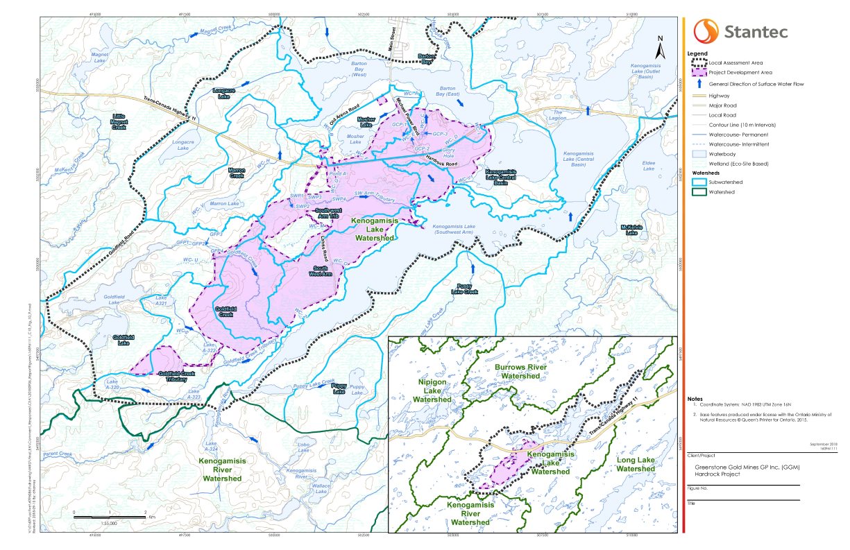
Source: Stantec, September 2018
5.2 Human Environment
The Project is located in the Municipality of Greenstone (population 4636, according to 2016 census), approximately five kilometres south of the Ward of Geraldton (population 1828), and 275 kilometres northeast of Thunder Bay (population 121 596). The Project is centred near the intersection of Highway 11 (Trans-Canada Highway) and Michael Power Boulevard, which provides access to Geraldton.
General land and resource uses
The landscape of the project development area is a brownfield area including the presence of historical tailings and mine shafts from historical mining activity, two sawdust piles at the end of Lahtis Road from historical logging activity, and various trails that may be decommissioned mining or forestry roads. The historical MacLeod-Mosher Mining Headframe and the Discover Geraldton Interpretive Centre, located at the Highway 11 and Michael Power Boulevard intersection, are local tourist attractions. The Kenogamisis Golf Club is located on Michael Power Boulevard, just north of Highway 11. MacLeod Provincial Park is located across the Central Basin of Kenogamisis Lake, and offers camping, hiking, fishing, swimming, boating, canoeing, biking, picnicking and bird-watching. Commercial resource activities include trapping, baitfish harvesting, guide outfitting, forestry and mineral exploration.
Indigenous land and resource uses
The Project is located in the James Bay Treaty Number 9 territory, which affords hunting, trapping and fishing rights and protections to its signatories throughout the treaty area. The Robinson Superior Treaty territory is located to the west, south and east of the Project. Figure 12 illustrates the location of the Project relative to these treaties.
The Ginoogaming Reserve is the closest First Nation reserve land, located 22 kilometres east of the Project. The Long Lake 58 Reserve is located 28 kilometres east of the Project, and the Aroland Indian Settlement Reserve is located 90 kilometres north of the Project. Animbiigoo Zaagi'igan Anishinaabek's administrative office is currently located in Beardmore, 80 kilometres west of the Project. The community's Lake Nipigon Reserve is under development, and will be located approximately 24 kilometres west of the Project. The Métis Nation of Ontario indicates that a historical Métis community exists north of Lake Superior and within the Nipigon area specifically, comprised of the interconnected Métis populations at Lake Nipigon, Long Lake, Pic River, and other locations in the area.
Hunting, trapping, fishing, plant gathering and other cultural practices continue throughout the regional assessment area for current use of lands and resources for traditional purposes (Figure 3). The Métis Nation of Ontario exercise their harvesting rights for hunting, fishing and gathering within the Lakehead, Nipigon, and Michipicoten traditional territories. Lahtis Road is used to access areas in and around the Southwest Arm of Kenogamisis Lake. Cultural sites (including trails and travelways), sacred areas, communal gathering areas and habitation sites are used by Indigenous groups throughout the regional assessment area for current use of lands and resources for traditional purposes. Indigenous groups have identified cultural sites in the project development area and local assessment area for current use of lands and resources for traditional purposes, and continue to use traditional gathering places to come together for socializing, harvesting or ceremonial purposes.

Source: Stantec, September 2018
6 Predicted Changes to the Environment
6.1 Atmospheric Environment
The Project could cause residual effects on the atmospheric environment through:
- increase in ambient air concentrations of contaminants;
- increase in ambient noise levels; and
- increase in vibrations from blasting activities near Kenogamisis Lake.
The Agency's summary of the proponent's assessment on the changes to the atmospheric environment considered the views expressed by federal departments, provincial ministries and Indigenous groups. The Agency used this summary in its analysis of effects on fish and fish habitat (Section 7.1), Indigenous use (Section 7.3) and human health (Section 7.4), including mitigation and follow-up program measures.
Description of the Existing Environment
The local and regional assessment areas for air quality, noise, and vibration are shown in Section 1.2.5. Existing concentrations of total particulate matter, particulate matter under 10 micrometres (PM10), fine particulate matter (PM2.5), nitrogen dioxide, sulphur dioxide, carbon monoxide and metals are below applicable federal standards.Footnote 4 Existing concentrations of benzene and benzo(a)pyrene were above applicable provincial standards Footnote 5. Existing noise levels are below applicable provincial standards.Footnote 6 Existing vibration levels were not measured, as no existing sources of vibration were identified in the local assessment area.
6.1.1 Increase in ambient air concentrations of contaminants
Proponent's Assessment of Environmental Effects, and Proposed Mitigation and Monitoring
Air emissions were modelled using conservative assumptions for both construction and operations. The assumptions were based on a time period during each project phase with the highest mass of material moved.
Emissions of particulate matter and metals from dust, and emissions of nitrogen oxides, sulphur dioxide, carbon monoxide and volatile organic compounds from tailpipe emissions will result in construction from the realignment of Highway 11; excavation of the historical tailings; construction of the ore stockpile, overburden storage areas, waste rock storage areas, and tailings management facility; excavation of the open pit; material handling; and use of unpaved roads. Blasting activities will also cause emissions of nitrogen dioxide and carbon monoxide.
Emissions of particulate matter and metals from dust will result in operations from open pit operations (blasting, drilling, and excavating); material handling and transport; onsite ore and waste rock management and stockpiling; wind erosion from stockpiles prior to progressive revegetation; ore processing (dropping, crushing and smelting); and movement of the historical tailings. Blasting will also cause emissions, including nitrogen dioxide and carbon monoxide. Destruction of cyanide used in refining will emit sulphur dioxide. The combustion of diesel in the first years of operations will also cause emissions of combustion products (nitrogen dioxide, sulphur dioxide, carbon monoxide).
Infrequent exceedances (up to 0.3 percent of the time, or one day per year) of applicable air quality standards are predicted within parts of the local assessment area for 24-hour average concentrations of total suspended particulate and PM10. These exceedances would occur during operations, to the east of the project development area, across from the open pit. Concentrations of PM2.5 and nitrogen dioxide are also predicted to increase within parts of the local assessment area during construction and operations, but would not exceed applicable air quality standards. While exceedances for annual average benzene and 24-hour and annual average benzo(a)pyrene are predicted, this results from measured background levels that are already above applicable air quality standards; the increase for concentration of benzene is approximately 11 percent of the standard and the increase for concentration of benzo(a)pyrene is approximately 30 percent of the standard. A discussion of how changes to air quality could affect Indigenous use is found in Section 7.3, and on human health in Section 7.4.
Measures to reduce changes to air quality include:
- Control fugitive dust emissions from roads, material handling and storage areas/stockpile by applying water sprays, chemical suppressants, dust sweeping, gravel application, truck wheel washing stations, and enclosure of dust sources;
- Use dust suppressants (e.g., water) to reduce airborne dust, including watering unpaved road surfaces when dry;
- Use a scrubber on the induction furnace to control emissions;
- Enforce speed limits of up to 65 kilometres per hour on unpaved roads, and reduce haul routes to and within the project development area, to reduce dust emitted through vehicles;
- Equip crushers with dust collection systems (baghouse or equivalent) to control fugitive emission during ore crushing and transfer;
- Enclose the mill feed ore storage area, to control dust emissions; and,
- Cover or wet transported material, including aggregate, borrow and historical tailings, to reduce generation of fugitive dust.
Ambient air monitoring will include sampling of total suspended particulate at four to five locations near the project development area, and real-time monitoring of PM10 at one upwind and two downwind locations in the local assessment area near the project development area. Metals concentrations would be monitored from the filters that collected total suspended particulate during the first year of operations, with the need for continued metals sampling to be evaluated after the first year. Road dust sampling would validate assumptions made about silt content on roads, and to confirm predictions about the formation of particulate.
Views expressed
Animbiigoo Zaagi'igan Anishinaabek, Aroland First Nation and Ginoogaming First Nation indicated that the proponent needs to monitor Project-related dust for trace metal concentrations, to understand potential risks with the inhalation or deposition of Project-related dust. The proponent indicated that trace metals concentrations would be determined by analysis of collected ambient particulate or dust fall samples, and that metals would be analyzed until sufficient information has been collected confirming that ambient metals levels are below applicable criteria.
Environment and Climate Change Canada and the Ontario Ministry of the Environment, Conservation and Parks Raised questions about the conservativeness of assumptions made about control efficiency (degree of dust captured by the dust suppressant) and silt content (portion of particulate that is too fine to be captured by water). The proponent indicated that the assumptions are consistent with peer-reviewed data sets from the United States Environmental Protection Agency and with other mining environmental assessments in Ontario. The proponent agreed to monitor for silt content as part of its air quality monitoring program and apply additional mitigation measures as required.
6.1.2 Increase in ambient noise levels
Proponent's Assessment of Environmental Effects, and Proposed Mitigation and Monitoring
The noise model was conservative and assumed that all equipment would operate simultaneously at 100 percent throughput, and that open pit blasting would occur near the surface to maximize noise propagation. Noise emissions during operations will result from onsite haulage of materials; use of excavators and dozers; stockpiling of low-grade ore and waste rock; operations at the process plant and other facilities; mining waste management, including the waste rock storage areas and the tailings management facility; power generation activities; and blasting.
Exceedances of provincial noise standards6 are predicted within 0.5 kilometres of the project development area, particularly to the east and south of the open pit, and along the western shoreline of Kenogamisis Lake. Noise levels from blasting are expected to remain within provincial noise standards for blasting Footnote 7 outside of the project development area. A discussion of how changes to noise levels could affect Indigenous use is found in Section 7.3.
Measures to reduce changes to noise levels include:
- Where possible, major construction activities will be scheduled to take place during daytime hours (i.e., 07:00 to 19:00), to avoid sensitive nighttime periods.
- Advise nearby residents of major noise generating activities, and implement a complaint response procedure to address noise complaints should they arise.
- Where possible, conduct blasting between 10:00 and 16:00 on weekdays, avoiding statutory holidays.
- Install noise reduction measures (e.g., muffler systems) on equipment, and regularly maintain mobile equipment;
- Use doors providing a Sound Transmission Class of STC-20 or better in buildings enclosing noise generating equipment, and keep the doors closed when not in use; and,
- Use air inlet and discharge silencers for exhaust stacks associated with diesel or natural gas-fueled generators.
An ambient noise monitoring program would be conducted for construction activities during summer months, and during the first year of Phase 1 and of Phase 2 of operations (Section 2.3.2). The monitoring program would be designed to meet provincial regulatory requirements. Blasting noise would be measured using a tool capable logging peak sound pressure level at locations and frequency to be determined.
6.1.3 Increase in vibrations from blasting activities near Kenogamisis Lake
Blasting in the open pit would be the only source of vibrations. Federal standards Footnote 8 could be exceeded for vibrations when blasting occurs less than 275 metres from the shoreline of the Central Basin of Kenogamisis Lake. Vibration levels at identified points of reception are predicted to remain within provincial standards Footnote 9. A discussion of how changes to vibration levels could affect fish habitat is found in Section 7.1.
During construction and operations, blasting events would be monitored in accordance with federal and provincial regulatory requirements. Measures to reduce changes to vibration levels include:
- Advise nearby residents of major noise generating activities, and implement a complaint response procedure to address noise complaints should they arise.
- Where possible, major construction activities will be scheduled to take place during daytime hours (i.e., 07:00 to 19:00), to avoid sensitive nighttime periods.
- Where possible, conduct blasting between 10:00 and 16:00 on weekdays, avoiding statutory holidays.
6.2 Water Quantity
The Project could cause residual effects on water quantity through:
- decrease in mean annual flow in Goldfield Creek; and
- increase in mean annual flow in Southwest Arm Tributary.
The Agency's summary of the proponent's assessment on the changes to water quantity considered the views expressed by federal departments, provincial ministries and Indigenous groups. The Agency used this summary in the analysis of fish and fish habitat (Section 7.1), including mitigation and follow-up program measures.
Description of the Existing Environment
The local and regional assessment areas for groundwater and surface water are shown in Section 1.2.5. Groundwater is one of the main contributors of flow towards surface waterbodies in the project development area, including Goldfield Creek and Southwest Arm Tributary. Groundwater flow is controlled by topography, generally flowing southeast towards Kenogamisis Lake, with discharge in the low-lying creeks, rivers, wetlands, and lakes. Groundwater in the northern portion of the project development area flows toward Barton Bay, Central Basin and the Southwest Arm of Kenogamisis Lake. Groundwater in the southern portion of the project development area flows towards the Southwest Arm of Kenogamisis Lake, Goldfield Creek, Southwest Arm Tributary and associated wetlands.
The Southwest Arm Tributary originates near two wetland ponds (SWP1 and SWP2) on the west side of Lahtis Road, and flows eastward for approximately 3.3 kilometres into the northern extent of the Southwest Arm of Kenogamisis Lake. Watercourse K (WC-K) and Watercourse L (WC-L) form the headwaters of this stream.
Goldfield Creek is a larger watercourse within the Goldfield Creek Subwatershed (Figure 11). Goldfield Creek originates from Goldfield Lake and drains in an easterly direction, discharging to the Southwest Arm of Kenogamisis Lake. Goldfield Creek Tributary, a smaller tributary to Goldfield Creek, drains a wetland area and Lake A-321 to the south of Goldfield Lake and merges with Goldfield Creek, just upstream of its outlet to the Southwest Arm of Kenogamisis Lake.
6.2.1 Decrease in mean annual flow in Goldfield Creek
Proponent's Assessment of Environmental Effects, and Proposed Mitigation and Monitoring
A decrease in mean annual flow in Goldfield Creek is predicted due to installation of the tailings management facility over most of Goldfield Creek; however, the construction of the Goldfield Creek diversion channel would mitigate some of the decrease in mean annual flow. The collection of seepage and runoff around the tailings management facility, and redirection of this water to the mill for processing, which would minimize water taking from the Southwest Arm of Kenogamisis Lake, would also result in a decrease of mean annual flow.
Through operations and decommissioning, the mean annual flow through Goldfield Creek, at the point it intersects with the Southwest Arm of Kenogamisis Lake, would decline to a predicted maximum of 75 percent compared to baseline conditions. However, water levels in the Southwest Arm of Kenogamisis Lake are predicted to remain within five percent of baseline conditions during all phases of the Project. To verify the predicted changes in flow in Goldfield Creek, groundwater levels will be monitored upgradient, cross gradient, and downgradient of the tailings management facility. To verify surface water levels and flows in surrounding waterbodies, monitoring would occur within the Goldfield Creek Tributary and Kenogamisis Lake.
6.2.2 Increase in mean annual flow in Southwest Arm Tributary
Proponent's Assessment of Environmental Effects, and Proposed Mitigation and Monitoring
An increase in mean annual flow in Southwest Arm Tributary is predicted during all phases of the Project, due to the connection of the new Goldfield Creek diversion channel; and at abandonment, due to seepage from waste rock storage areas C and D and the pit lake.
The mean annual flow is predicted to increase by 267 percent from baseline conditions during operations. The largest change in mean annual flow (369 percent from baseline conditions) is predicted during abandonment, due to recharge from waste rock storage areas C and D as well the pit lake. In addition, once the pit lake is filled and the water in the seepage collection ponds meet applicable water quality standards Footnote 10, the flow from the seepage collection ponds would be directed overland to the Southwest Arm Tributary, further contributing to the increase in flow in the tributary. To verify the predicted changes in levels and flows of Southwest Arm Tributary, both groundwater and surface water would be monitored during all phases of the Project.
Views expressed
Aroland First Nation, Fisheries and Oceans Canada and Environment and Climate Change Canada requested further details on the ability of the Southwest Arm Tributary to accept additional flows from the proposed Goldfield Creek diversion channel. The proponent confirmed that the existing Southwest Arm Tributary has sufficient capacity to accommodate increased flows, up to and including the 1-in-100-year storm and Timmins storm Footnote 11.
6.3 Water Quality
The Project could cause residual effects on water quality through:
- increase in contaminants in the Southwest Arm of Kenogamisis Lake;
- increase in contaminants in the Southwest Arm Tributary; and
- increase in contaminants in Mosher Lake.
The Agency's summary of the proponent's assessment on the changes to water quality considered the views expressed by federal departments, provincial ministries and Indigenous groups. The Agency used this summary in the analysis of fish and fish habitat (Section 7.1), migratory birds (Section 7.2), Indigenous use (Section 7.3) and human health (Section 7.4), including mitigation and follow-up program measures.
Description of the Existing Environment
The local and regional assessment areas for groundwater and surface water are shown in Section 1.2.5. Baseline data show exceedances of the applicable water quality standards Footnote 12 for arsenic and iron. These elevated concentrations are attributed to historical mining activity. The historical MacLeod and Hardrock tailings within the project development area (Figure 1) leach metals including arsenic, cobalt, nickel, zinc, cadmium, cyanide, aluminum, and selenium into nearby waterbodies. Geochemical investigations indicate that mine rock and tailings from the Project would be mostly non-acid generating.
The Kenogamisis Lake watershed (Figure 11) consists of several contributing subwatersheds, and their water quality reflects the varying levels of human activities that took place near them. The Goldfield Creek and the Southwest Arm Tributary subwatersheds are further from the historical mining activities, and drain east towards the Southwest Arm of Kenogamisis Lake (Figure 11). Although the Southwest Arm Tributary has concentrations of arsenic exceeding applicable water quality standards, samples from the Goldfield Creek and Southwest Arm Tributary subwatersheds show fewer exceedances of applicable water quality standards for metals.
Among the basins of Kenogamisis Lake, Barton Bay has the highest mean concentration of metals, including arsenic. Central Basin, which is connected with the Southwest Arm of Kenogamisis Lake, has lower metal concentrations than Barton Bay, while Southwest Arm has the lowest concentrations of metals. Mosher Lake subwatershed, located east of historical mining activities, drains northeast towards Barton Bay; the mean arsenic concentration in Mosher Lake exceeds applicable water quality standards.
6.3.1 Increase in contaminants in the Southwest Arm of Kenogamisis Lake
Proponent's Assessment of Environmental Effects, and Proposed Mitigation and Monitoring
Concentrations of arsenic, mercury, total phosphorus, and unionized ammonia are predicted to increase above baseline conditions in the Southwest Arm of Kenogamisis Lake, due to discharge of treated mine and sewage effluent; and seepage through groundwater from waste rock storage area D, the tailings management facility and the ore stockpile. These increases would be long-term and irreversible, as while effluent would be treated during operations, seepage through groundwater from project components would continue in decommissioning and abandonment.
The effluent discharge location (Figure 9), approximately 100 metres offshore in the Southwest Arm of Kenogamisis Lake, would receive the contaminants predicted to increase above baseline conditions. As shown in Table 5, arsenic concentrations are expected to meet applicable water quality criteria Footnote 13 within a mixing zone extending two kilometres of the discharge location, total phosphorous within 30 metres, and unionized ammonia within 30 metres Footnote 14.
|
Parameter |
Selected guideline concentration (micrograms per litre) |
Distance from effluent discharge location where guideline is predicted to be met (metres) |
|---|---|---|
|
Arsenic |
5 |
2000 |
|
Total phosphorus |
20 |
30 |
|
Unionized ammonia |
20 |
30 |
As mitigation for changes in water quality of Southwest Arm of Kenogamisis Lake during operations, contact water would be collected in a central pond M1 through a network of smaller collection ponds (A1, A2, B1, B2, C1, D1, and D2). Water collected in pond M1 would be used to meet the process water requirements at the process plant, and only excess water would be sent to the effluent treatment plant and discharged. Contact water from the tailings management facility would be collected in a separate set of collection ponds, and returned to the tailings management facility reclaim pond, to be recirculated to meet the process water requirements at the process plant. A cyanide destruction circuit would be used to reduce cyanide concentrations in the process plant, and therefore in mine effluent.
The seepage collection system is predicted to capture 88 percent of seepage, with the remaining 12 percent reaching the Southwest Arm of Kenogamisis Lake, either directly or via Goldfield Creek Tributary. Seepage would be from the tailings management facility, waste rock storage area D and from the ore stockpile. Historical tailings (Section 2.3.1), excavated mainly to build the open pit and the realigned highway, would be likely stored in a waste rock storage area with a drainage capture system during construction and for the first two years of operations, and then permanently relocated in the tailings management facility, laid over a two-metre layer of fresh tailings. Although the historical tailings are presently known to seep into surrounding open waters, the groundwater model assumed that all seepage from the historical tailings would be captured.
At decommissioning and abandonment, surface runoff and seepage from the waste rock storage areas and the tailings management facility into the Southwest Arm of Kenogamisis Lake would be reduced by directing runoff and seepage from the waste rock storage areas towards pond M1, and from the tailings management facility to the tailings management facility reclaim pond; both ponds would then be redirected to the open pit. When the water in the pit lake reaches a depth of 100 metres, fresh water from the Southwest Arm of Kenogamisis Lake would be pumped in to accelerate the filling of the open pit (Section 2.3.4) while collected seepage would be pumped into the open pit below this surface layer and create a stratified freshwater layer at the top of the pit lake. The pit lake would then be connected to the Southwest Arm of Kenogamisis Lake.
At decommissioning and abandonment, concentrations of arsenic, mercury, and total phosphorus are predicted to exceed baseline conditions in the Southwest Arm of Kenogamisis Lake, but remain below the applicable water quality standard Footnote 15. These increases would be due to seepage through groundwater from the tailings management facility, the waste rock storage areas, and connection of the pit lake with the Southwest Arm of Kenogamisis Lake during abandonment. To verify predictions that the applicable water quality standard would be met, monitoring is proposed at the pit lake during filling and prior to its connection with the Southwest Arm of Kenogamisis Lake. In the event that the desired water quality is not achieved, the discharge would be treated using the conventional effluent treatment plant to meet water quality discharge criteria, if a constructed wetland is found to be ineffective or is not implemented near the end of the open pit outlet channel to provide further treatment.
The removal of infrastructure during decommissioning, and the presence of the waste rock storage areas and the tailings management facility can cause loadings of suspended solids into the Southwest Arm of Kenogamisis Lake; this release of suspended solids would be mitigated through progressive rehabilitation of waste rock storage areas and the tailings management facility by using a soil cover and vegetation. Sedimentation control measures, such as silt fences would also be used to ensure sediments do not enter local waterbodies.
Views expressed
Aroland First Nation, Ginoogaming First Nation and Long Lake #58 First Nation raised concerns related to effects on Lake A-322 Footnote 16 from overprinting and seepage from the tailings management facility, as this lake is a preferred fishing location for these groups. The proponent moved the location of the tailings management facility to avoid overprinting of this lake. Although groundwater modelling did not show any seepage discharging from tailings management facility into Lake A-322, the proponent committed to groundwater monitoring between Lake A-322 and the tailings management facility, as well as surface water monitoring in Goldfield Creek Tributary downstream of Lake A-322.
Animbiigoo Zaagi'igan Anishinaabek, Métis Nation of Ontario, Aroland First Nation, Ginoogaming First Nation, Long Lake #58 First Nation, Environment and Climate Change Canada and Natural Resources Canada raised concerns related to management of the historical MacLeod and Hardrock tailings as they are disturbed in their original location, or when they are relocated to temporary or final storage locations. The proponent committed to establishing collection ditches prior to excavation or relocation of historical tailings, in their existing, temporary, and final locations, to ensure that seepage from the historical tailings does not enter the surrounding waterbodies.
Pays Plat First Nation, Constance Lake First Nation, Aroland First Nation and Long Lake #58 First Nation expressed concerns related to effects on surface water quality downstream of the local assessment area. To address these concerns, the proponent committed to install additional water quality monitoring stations downstream in Kenogamisis Lake, to allow detection of potential contaminants in surface water before they reach Long Lake.
Métis Nation of Ontario raised concerns about potential changes to mercury and arsenic concentrations in Southwest Arm of Kenogamisis Lake and Barton Bay, which may affect fish in these waterbodies. The proponent and the Métis Nation of Ontario have agreed to work together to establish a monitoring program to alleviate the concerns.
6.3.2 Increase in contaminants in Southwest Arm Tributary
Proponent's Assessment of Environmental Effects, and Proposed Mitigation and Monitoring
Concentrations of arsenic and mercury would exceed baseline conditions in the Southwest Arm Tributary during operations and abandonment, while total phosphorous would exceed in abandonment. However, only arsenic would exceed applicable water quality standards Footnote 17. These increases would be due to the connection of the Southwest Arm Tributary with the Goldfield Creek diversion channel; continuous seepage through groundwater from waste rock storage areas C and D; and discharge from the tailings management facility reclaim pond during a portion of abandonment.
With the increase in flow in the Southwest Arm Tributary (Section 6.2.1), 15 hectares would be permanently inundated around the Southwest Arm Tributary, where there would be potential for methylation of mercury. The potential increase in methylmercury, based on the expected increase in mean annual flow of the Southwest Arm Tributary, is predicted to be approximately 0.0001 micrograms per litre, which would remain within applicable water quality standards.
Once water from the tailings management facility reclaim pond is no longer required to be pumped into the bottom of the open pit, it would be discharged through the Goldfield Creek diversion channel to the Southwest Arm Tributary. If the water from the tailings management facility reclaim pond exceeds applicable criteria for cobalt and arsenic, the discharge would be treated using the conventional effluent treatment plant to meet water quality discharge criteria, if a constructed wetland is found to be ineffective or is not implemented near the end of the open pit outlet channel to provide further treatment.
6.3.3 Increase in contaminants in Mosher Lake
Proponent's Assessment of Environmental Effects, and Proposed Mitigation and Monitoring
Concentrations of arsenic, mercury, and total phosphorus, would exceed baseline conditions in Mosher Lake during operations, decommissioning and abandonment. Arsenic would be the only contaminant to exceed the applicable water quality standard Footnote 18. These increases in contaminants would be due to seepage through groundwater from waste rock storage area C.
The open pit drawdown and the seepage collection system would capture the majority of seepage, with a small portion reporting to Mosher Lake. At decommissioning and abandonment, the open pit drawdown would reduce as the open pit fills, and the seepage rate from waste rock storage area C would increase. A vegetative soil cover on waste rock storage area C would mitigate changes to water quality of Mosher Lake by reducing infiltration.
6.4 Terrestrial Environment
The Project could cause residual effects on the terrestrial, including wetland, environment through:
- loss of habitat from the direct removal of vegetation (i.e., vegetation clearing); and
- changes to quality and function of habitat.
The Agency's summary of the proponent's assessment on the changes to the terrestrial environment considered the views expressed by federal departments, provincial ministries and Indigenous groups. This summary has been used by the Agency to inform the analysis of effects to fish and fish habitat (Section 7.1), migratory birds (Section 7.2), Indigenous use (Section 7.3), human health (Section 7.4), and other effects related to federal decisions (Section 7.7), including mitigation and follow up program measures.
Description of the Existing Environment
The local and regional assessment areas for vegetation communities are shown in Section 1.2.5. White and black spruce, tamarack, balsam fir and jack pine are common throughout the regional assessment area with frequent occurrences of deciduous vegetation communities, generally comprised of white birch, trembling aspen and balsam poplar. Boreal wetlands occur in the project development area and throughout the local assessment area, and consist of swamps, marshes, bogs and fens, with many containing a shallow open water component. The regional assessment area, which incorporates the Burrows River, Kenogamisis River and Kenogamisis Lake watersheds (Figure 5), contains similar ecosystem and habitat types to those found within the local assessment area.
Existing areas of disturbance within the project development area occur primarily at the north end, including the areas of the historical tailings and aggregate extraction, urban settlement (MacLeod Townsite and Hardrock Townsite) and the Highway 11 corridor.
Soil within the areas of the historical process plant sites and in the historical tailing areas contain concentrations of metals, particularly arsenic, in excess of provincial standards.Footnote 19 Contaminated soil has the potential to affect water quality (Section 6.3), with potential effects to fish and fish habitat (Section 7.1), Indigenous use (Section 7.3) and health and socio-economic conditions (Section 7.4).
The regional assessment area is used by wildlife for breeding, nesting, foraging, and overwintering. Wildlife observed in the regional assessment area includes various mammals including moose, deer and furbearers, birds, waterfowl, reptiles and amphibians, which are commonly observed in the Boreal Region. The upland forests and wetlands in the regional assessment area provide suitable habitat for wildlife of interest to Indigenous groups (Section 7.3.1) as well as migratory birds (Section 7.2.2) and species at risk (Section 8.1).
6.4.1 Loss of Habitat
Proponent's Assessment of Environmental Effects, and Proposed Mitigation and Monitoring
Approximately 2200 hectares of upland, wetland and open water habitat within the project development area will be removed to accommodate project components listed in Section 2.2. A summary of direct habitat loss from the Project by habitat type is provided in Table 6.
|
Habitat Type |
Area in PDA (ha) |
Area in LAA (ha)(a) |
Area in PDA Removed During Construction (ha) |
Area in PDA Rehabilitated During Decommissioning (ha) |
Description of Vegetation Community After Decommissioning |
|---|---|---|---|---|---|
|
PDA = Project Development Area; LAA = Local Assessment Area; RAA = Regional Assessment Area; ha = hectares; % = percent; - = not applicable (a) LAA area excludes PDA area. (b) Totals may not be exact due to rounding errors. (c) The vegetation communities, upland forests and bogs, will not be available within the project development area following decommissioning. They will be replaced with a combination of other habitat types including early successional habitat, marshes and open aquatic habitat, open water and disturbed habitat. |
|||||
|
Upland - Forested - Conifer |
869 |
823 |
1133 (b) |
0 |
-(c) |
|
Upland - Forested - Deciduous |
209 |
565 |
|||
|
Upland - Forested - Mixed wood |
55 |
45 |
|||
|
Upland - Early Successional |
- |
- |
- |
564 |
Anticipated growth of poplar and shrub species during decommissioning |
|
Upland - Early Successional and Exposed Rock |
- |
- |
- |
593 |
Rehabilitated waste rock storage areas |
|
Upland - Meadow |
0 |
10 |
0 |
465 |
Anticipated mosaic of graminoid (plants with grass-like features) cover and exposed rock |
|
Wetland - Bog |
5 |
0 |
5 |
0 |
-(c) |
|
Wetland - Fen |
21 |
102 |
20 |
8 |
The project development area will mostly be cleared for the Project. However approximately 8 ha of fen habitat is expected to be retained. |
|
Wetland - Marsh |
65 |
155 |
63 |
37 |
Includes marsh communities along creeks and lakeshore and rehabilitated marsh along Goldfield Creek diversion channel |
|
Wetland - Marsh and Open Aquatic |
- |
- |
0 |
151 |
Rehabilitated marsh and open water within Goldfield Creek diversion channel, aggregate source S4 and tailings management facility. |
|
Wetland - Swamp |
719 |
632 |
727 |
77 |
The project development area will be mostly cleared for the Project. However, approximately 77 hectares of swamp habitat is expected to be retained. |
|
Open Water |
15 |
1265 |
15 |
131 |
Includes the pit lake, tailings management facility, and Goldfield Creek diversion channel open water components. |
|
Disturbed |
245 |
103 |
245 |
163 |
Includes existing disturbed areas including collection ponds, infrastructure remaining at decommissioning (non-rehabilitated areas after active closure ends), and areas of exposed rock associated with the tailings management facility dam. |
|
Total(b) |
2200 |
3700 |
2200 |
2200 |
- |
The habitat loss due to the Project translates to a loss of 37 percent of habitat in the local assessment area (44 percent of upland, 48 percent of wetland, 70 percent of disturbed and 1 percent of open water habitats). The project design includes approximately 162 hectares of upland forest and 85 hectares of wetlands that would be retained as a forested buffer for the Goldfield Creek diversion channel.
While the wildlife habitat within the project development area is assumed to be unlikely to return to baseline conditions, it is also predicted that similar upland and wetland habitat will remain available to wildlife within the local assessment area and regional assessment area. To mitigate the loss of habitat, progressive revegetation and regrading will be undertaken in accordance with provincial requirements.Footnote 20 Progressive revegetation will be with native species to generate upland and wetland habitat in the project development area, to provide ground cover and develop early successional growth. Multiple decades would be required for the vegetation to mature as potential habitat.
6.4.2 Changes to quality and function of habitat
Proponent's Assessment of Environmental Effects, and Proposed Mitigation and Monitoring
Project activities may indirectly alter wildlife habitat quality and function as a result of vegetation clearing, dust and noise generation (Section 6.1), and changes to water quantity and quality (Sections 6.2 and 6.3).
Although there may be localized effects to wildlife habitat within the project development area and local assessment area, habitat quality and function across the regional assessment area will be retained. Project components may reduce wildlife habitat connectivity, therefore restricting wildlife movement, within the project development area and local assessment area. Given the existing fragmentation of wildlife habitat within the project development area and the extent of wildlife habitat within the local and regional assessment areas, changes to wildlife habitat connectivity within the regional assessment area are not predicted.
The Project may result in the potential introduction and spread of invasive and exotic species within 30 metres of the project development area. The project development, local assessment and regional assessment areas already host invasive and exotic species, along the Highway 11 corridor due to existing anthropogenic activity. To prevent the spread and introduction of invasive and exotic species to wildlife habitat that is not currently affected, clean, coarse fill material will be used for grading and selecting native species for revegetation. As part of a follow-up program, invasive species surveys will be conducted during the Project until decommissioning, and measures will be taken to remove observed invasive species through manual, mechanical and, if necessary, chemical methods.
Indirect effects to wildlife habitat exposed to residual dust and noise, following the implementation of mitigation measures (Section 6.1.1 and 6.1.2), would be restricted to wildlife habitat immediately adjacent to the project development area during the construction, operation and into decommissioning. Sensory disturbance may cause wildlife to avoid or underutilize habitat adjacent to the project development area, although these disturbances would cease during decommissioning.
While wetland function within the local assessment area may be degraded due to changes in water quantity and water quality (Sections 6.2 and 6.3), wetland quality and function across the regional assessment area would be retained. Proposed mitigation measures to minimize the effect of the Project on wetland quality and function include erosion and sediment controls, and the re-establishment of drainage patterns where feasible.
Views expressed
Animbiigoo Zaagi'igan Anishinabek, Aroland First Nation and Ginoogaming First Nation expressed concern regarding the potential introduction or spread of terrestrial invasive species associated due to project activities, and recommended implementing the provincial protocol Footnote 21. The proponent indicated that while the provincial protocol is not applicable to mines, they committed to ensuring previously used equipment is cleaned prior to entering the project development area.
7 Predicted Effects on Valued Components
7.1 Fish and Fish Habitat
The Project could cause residual effects on fish and fish habitat through:
- mortality and effects on fish health; and
- loss or alteration of fish habitat.
The Agency is of the view that the Project is not likely to cause significant adverse effects on fish and fish habitat, after taking into account the proposed key mitigation measures (Box 7.1-1). The Agency recommends follow-up program measures (Box 7.1-2) to evaluate the accuracy of the predictions related to fish and fish habitat, and to determine the effectiveness of mitigation measures proposed to minimize effects on fish and fish habitat.
The Agency's conclusions are based on its analysis of the proponent's assessments as well as the views expressed by Environment and Climate Change Canada, Fisheries and Oceans Canada, Health Canada, the Ontario Ministry of Natural Resources and Forestry, the Ontario Ministry of the Environment, Conservation and Parks, and Indigenous groups.
Description of the Existing Environment
Fish species in Kenogamisis Lake include Walleye, Lake Whitefish, Northern Pike, Yellow Perch, and a variety of small-bodied fish. The Southwest Arm of Kenogamisis Lake has the highest diversity of fish species, and other watercourses including the Southwest Arm Tributary and Goldfield Creek provide potential spawning and rearing habitat for species in the Southwest Arm of Kenogamisis Lake (Figure 11). Watercourses near the historical tailings have been degraded, and provide marginal fish habitat. Ephemeral watercourses, such as watercourses WC-G and WC-I, provide potential habitat for fish during wet periods, however these watercourses have low species diversity and fish abundance. No fish species at risk have been documented, and they are not anticipated to occur in the local assessment area. Mosher Lake provides suitable habitat for Yellow Perch, Northern Pike, and a variety of small-bodied fish. The benthic invertebrate community in Mosher Lake is impaired due to its proximity to the area of historical mining.
Metal concentrations were measured in muscle tissue of large-bodied and small-bodied fish. Walleye are frequently targeted for consumption by Indigenous people. Arsenic and mercury concentrations in Walleye from Kenogamisis Lake exceed reference conditions in Wildgoose Lake and Goldfield Lake, however the observed levels have not had an adverse biological effect on fish.
7.1.1 Mortality and effects on fish health
Proponent's assessment of environmental effects, mitigation and monitoring
Effects on fish populations from fish mortality due to construction of project components in or near waterbodies, and through the operation of the water intake and blasting activities associated with the Project, are expected to be negligible. Negligible effects on fish health are expected to occur due to changes to water quality from discharge of effluent during operations, and seepage from the tailings management facility and waste rock storage areas from operations to abandonment (Section 6.3.3).
With regards to Goldfield Creek, and other fish-bearing watercourses and ponds within the project development area that would be removed for construction of project components, measures would be implemented to salvage and relocate fish to an appropriate location, prior to construction of project components and according to relocation measures to be developed pursuant to the Fisheries Act. As described in Section 6.3.1, erosion and sedimentation control measures, such as progressive rehabilitation of waste rock storage areas, will be undertaken to control the release of sediments. Intake screens would be installed at the water intake structures in Southwest Arm of Kenogamisis Lake to mitigate fish entrainment and impingement to reduce fish mortality. Blasting in the eastern extension of the open pit would be controlled to reduce mortality or injuries to fish in the Central Basin of Kenogamisis Lake, as discussed in Section 6.1.3.
Measures will also be taken to mitigate changes in water quality, as discussed in Section 6.3, including seepage collection around the tailings management facility, waste rock storage areas and the ore stockpile, and effluent treatment before discharge in Southwest Arm of Kenogamisis Lake. Seepage collection would also be implemented to ensure that contact water from the historical MacLeod and Hardrock tailings would not impact the surrounding waterbodies throughout the Project, as they are excavated from their existing locations, temporarily stored in the waste rock storage areas, and then permanently relocated in the tailings management facility. Monitoring would include key water quality parameters, as well as fish population and health surveys conducted in Kenogamisis Lake, Mosher Lake and Southwest Arm Tributary to verify that fish are not adversely affected. During abandonment, pit lake water quality would be monitored to ensure that it is suitable Footnote 22 for discharge into the Southwest Arm of Kenogamisis Lake. If not, measures (as discussed in Section 6.3.1) such as creation of a constructed wetland near the end of the open pit outlet channel would be implemented prior to discharge to the Southwest Arm of Kenogamisis Lake.
Views Expressed
Aroland First Nation, Ginoogaming First Nation and Long Lake #58 First Nation expressed concerns related to adverse effects on fish due to increase in contaminants in groundwater and surface water of Kenogamisis Lake, and its associated lakes and streams, and requested that tissue sampling use the whole body of the fish. The proponent committed to monitoring whole-body fish tissue for contaminants including methylmercury, mercury and arsenic in fish from waterbodies, such as the Goldfield Creek diversion channel and Kenogamisis Lake. The proponent also committed to providing opportunities for Indigenous groups to be involved in surface water monitoring.
Agency Analysis and Conclusion
The Agency is of the view that, after taking into consideration the implementation of mitigation measures as described in Box 7.1-1, the Project would likely not have a significant effect on fish mortality or fish health.
The Agency notes while that the removal of waterbodies and watercourses, inadvertent impingement and entrainment of fish in the water intake structure, and blasting activities could result in fish mortality in the project development area, these effects would not change overall population levels of fish within the local assessment area. The proponent would relocate fish from waterbodies overprinted by project components and from areas where in-water works would be conducted to minimize serious harm to fish. To avoid harm due to vibration, the proponent would follow federal guidelines Footnote 23.
While fish health could be affected due to changes in water quality, these effects would not change the overall population levels of fish within the local assessment area. The proponent would mitigate the effects on fish in the Southwest Arm of Kenogamisis Lake, Mosher Lake and Southwest Arm Tributary by managing water quality as discussed in Section 6.3 of this Report. As discussed in Section 6.3.1, arsenic and phosphorus concentrations in the area near the effluent discharge location in Southwest Arm of Kenogamisis Lake are expected to be higher than the applicable water quality guidelines Footnote 24 during operations, and could be chronically toxic to aquatic organisms. Arsenic concentrations are also expected to exceed applicable water quality guidelines in the Southwest Arm Tributary (Section 6.3.2) and Mosher Lake (Section 6.3.3) due to seepage during operations and abandonment. After effluent discharge ceases in Southwest Arm of Kenogamisis Lake, federal Footnote 25 and provincial Footnote 26 regulatory requirements would continue to apply during decommissioning and abandonment. In addition, measures would be implemented to manage the historical MacLeod and Hardrock tailings when they are temporarily stored in the waste rock storage areas, and as they are permanently relocated to the tailings management facility, to ensure that contact water does not increase the concentration of contaminants in the surrounding waterbodies. Follow-up monitoring measures as noted in Box 7.1-2 are recommended to verify the proponent's prediction that water quality in the local assessment area would remain protective of fish health, to evaluate the effectiveness of the mitigation measures on fish mortality and health, and to determine the need for contingency measures to ensure fish are not affected.
Given the proposed mitigation measures and the definitions of the environmental effects rating criteria in Appendix A, the Agency is of the view that the magnitude of effects of the Project on mortality and effects on fish health would be low since the effects on individual fish are not expected to affect the regional status of fish populations and health. The geographic extent would be moderate, extending into the local assessment area. The duration of the effects would be long-term, occurring into abandonment. The effects would occur intermittently and are reversible once project activities cease. The timing of Project activities would be rated as moderate, as it may affect some sensitive activities in the fish lifecycle, such as spawning.
7.1.2 Loss or alteration of Fish Habitat
Proponent's assessment of environmental effects, mitigation and monitoring
Effects on fish habitat would occur as a result of habitat loss and alteration due to construction of project components, and habitat alteration due to discharge of treated effluent at the Southwest Arm of Kenogamisis Lake. Table 7 summarizes the anticipated habitat losses either from overprinting or from changes in water levels and flows in the local assessment area. The fish habitat removed by these activities would be counterbalanced by the implementation of a fish habitat offset plan, as required pursuant to the Fisheries Act.
The discharge of effluent in the Southwest Arm of Kenogamisis Lake during operations could cause an alteration to fish habitat due to eutrophication; however, these effects would largely be mitigated by the treatment of effluent prior to discharge. To verify predictions, monitoring of fish habitat due to changes in water quality would include nutrient levels, algae abundance, dissolved oxygen levels as well as population levels and health surveys. The monitoring would be conducted in Kenogamisis Lake, Mosher Lake and Southwest Arm Tributary to verify that fish habitat is not adversely affected.
|
Waterbody/ Watercourse |
Description of impact to fish habitat |
Area (hectares) |
|---|---|---|
|
Golf Course Ponds 2 and 3 |
Permanent loss of fish habitat due to overprinting by project components |
3.57 |
|
Goldfield Creek |
Permanent loss of fish habitat due to the diversion channel, plus a permanent alteration of fish habitat due to flow reduction |
2.82 |
|
Watercourse WC-D |
Permanent loss of fish habitat due to the open pit and highway realignment, plus a permanent alteration of fish habitat due to flow reduction |
0.21 |
|
Watercourse WC-C, WC-G, and WC-O |
Permanent loss of fish habitat due to overprinting by project components, plus a permanent alteration of fish habitat due to flow reduction |
0.25 |
|
Watercourses WC-F, WC-I, WC-M and WC-Z |
Permanent alteration of fish habitat due to flow reduction |
0.31 |
|
Total |
7.16 |
|
Views Expressed
Biigtigong Nishnaabeg, Aroland First Nation and Ginoogaming First Nation inquired about the losses of habitat associated with flow reductions. The proponent responded that flow models were used for the larger, permanently flowing streams such as Southwest Arm Tributary and Goldfield Creek. Since flow models were not applicable for smaller or ephemeral streams, losses were calculated on a case-by-case basis using conservative approaches.
Agency Analysis and Conclusion
The Agency is of the view that, after taking into consideration the implementation of mitigation measures, the Project would likely not have a significant effect on fish habitat. The Agency notes that the Project could have adverse effects on fish habitat from the construction of project components, and from changes in water quality in the local assessment area. The proponent has committed to implementing a fish habitat offset plan to meet federal regulatory requirements Footnote 27. In addition, the Agency recommends that the follow-up program evaluate the effectiveness of the measures to offset fish habitat.
The Agency understands that as the treated effluent from the mine and sewage is discharged into Southwest Arm of Kenogamisis Lake during operations (Section 6.3.1), total phosphorus and unionized ammonia are expected to increase above baseline levels in Southwest Arm of Kenogamisis Lake. These increases of phosphorus and unionized ammonia could cause eutrophication and impair fish habitat by affecting the concentrations of nutrients for aquatic organisms, algae abundance, and dissolved oxygen levels. However, under the worst-case scenario (maximum effluent discharge during low-flow conditions), the applicable water quality standard Footnote 28 would be met within a reasonable mixing zone of the effluent discharge location (Section 6.3.1). The Agency is of the view that the alteration of fish habitat would be localized within a short distance from the effluent discharge location.
Given the proposed mitigation measures and the definitions of the environmental effects rating criteria in Appendix A, the Agency is of the view that the magnitude of effects of the Project on fish habitat would be low, as a total of 7.16 hectares of fish habitat would be lost due to the Project, which would be counterbalanced by the fish habitat offset plan. The geographic extent would be moderate, as the effects would be restricted to the local assessment area. The duration of the effects would be medium-term, as the habitats created as part of the fish habitat offset plan would be established prior to the loss of habitats, but would require time during operations to become fully established and functional. The frequency of the effect would be continuous and reversible, as the habitat gains expected from the created habitats through the offsetting plan, pursuant to the Fisheries Act, would counterbalance any habitat losses in the long-term. The timing of Project activities would be rated as moderate, as it may affect some sensitive activities in the fish lifecycle, such as spawning.
Box 7.1-1: Key mitigation measures to address effects on fish and fish habitat
Mitigation Measures for mortality and effects on fish health
- Relocate fish before any work is conducted in or near water during construction and operations through a fish salvage and relocation plan conducted in accordance with the Fisheries Act requirements to avoid serious harm to fish.
- Implement measures during blasting activities to protect fish (and fish habitat, including spawning areas) as determined by the data obtained through blast monitoring, taking into account Fisheries and Ocean Canada's Guidelines for the Use of Explosives In or Near Canadian Fisheries Waters issued by Fisheries and Oceans Canada as it pertains to the use of explosives.
- Install screens on the water intake structures in Southwest Arm of Kenogamisis Lake, in accordance with Fisheries and Oceans Canada's Freshwater Intake End-of-Pipe Fish Screen Guideline and pursuant to the Fisheries Act requirements to avoid serious harm to fish.
- Manage water quality in mine effluents to meet the Metal and Diamond Mining Effluent Regulations; and to meet the requirements of the Fisheries Act in the Southwest Arm, Central Basin and Barton Bay of Kenogamisis Lake, Mosher Lake, Lake A-322, Southwest Arm Tributary and Goldfield Creek Tributary, while taking into account the Canadian Council of Minister of the Environment's Canadian Water Quality Guidelines for the Protection of Aquatic Life. This includes, but may not be limited to:
- Intercept and collect runoff and seepage from the waste rock storage areas including any temporary location of excavated historical tailings, overburden storage area, and ore stockpile, through the contact water collection ditches for reuse in project activities, and treat as necessary prior to discharging excess water into Southwest Arm of Kenogamisis Lake;
- Intercept and collect contact water from the tailings management facility including the final location of excavated historical tailings in collection ponds, and pump the collected contact water back to the tailings management facility during operations;
- Install and operate, during operations, a cyanide destruction circuit to reduce cyanide concentrations in mine effluent;
- Direct the contact water after operations from all collection ponds around the waste rock storage areas, overburden storage area, ore stockpile, and the tailings management facility to the open pit; and
- If necessary, treat impending open pit overflow water at abandonment prior to its connection with Southwest Arm of Kenogamisis Lake until monitoring results indicate that water quality complies with the Canadian Water Quality Guidelines for the Protection of Aquatic Life, as predicted in the environmental impact statement.
- Manage the unexcavated historical tailings to protect water quality in the Southwest Arm, Central Basin and Barton Bay of Kenogamisis Lake, Southwest Arm Tributary, and Goldfield Creek Tributary. Rehabilitate the exposed portions of the in situ historical tailings, completing the rehabilitation as soon after tailings have been excavated as technically feasible.
Mitigation Measures for loss or alteration of fish habitat
- Implement an offsetting plan for any serious harm to fish caused by the Project, pursuant to the Fisheries Act, and a fish habitat compensation plan for any fish habitat losses related to contact water disposal for the Project, pursuant to section 27.1 of the Metal and Diamond Mining Effluent Regulations. These plans would be developed with Fisheries and Oceans Canada and with Environment and Climate Change Canada, and through engagement with Indigenous groups.
- Apply erosion and sediment control measures during construction, operation and decommissioning, including but not limited to, the use of water for dust suppression, progressive rehabilitation of project components, and use of ditches and diversion berms to prevent erosion and maintain stream bank stability and silt fences, in accordance with the requirements of the Fisheries Act.
Box 7.1-2: Follow-up program measures recommended for fish and fish habitat
Follow-up program measures to address effects on fish and fish habitat
- Develop and implement, in consultation with Fisheries and Oceans Canada, a follow-up program to verify effectiveness of proposed blasting designs during construction and operations to evaluate the effectiveness of avoiding serious harm to fish, pursuant to the Fisheries Act. The monitoring program, developed in consultation with Fisheries and Oceans Canada, should include requirements to adjust blasting activities, based on site-specific blast monitoring data.
- Implement, during the construction and operations, quantitative monitoring measures for fish habitat creation described in the offsetting plan pursuant to the Fisheries Act, and in consultation with the Indigenous groups and Fisheries and Oceans Canada, to assess whether the created habitats are functioning as intended. In the event that measures described in the plan are ineffective, the proponent would implement contingency measures as required under the Fisheries Act.
- Conduct fish population and fish health surveys, during operations, to comply with the Fisheries Act and with the Metal and Diamond Effluent Regulations, including the Environmental Effects Monitoring, to verify that the changes in water quality, nutrient levels, algae abundance, and dissolved oxygen levels in Kenogamisis Lake, Mosher Lake and Southwest Arm Tributary do not cause adverse effects on fish and fish habitat. These monitoring results would inform a determination as to whether the implementation of additional mitigation measures is required. In case additional measures are implemented, also monitor the effectiveness of those measures.
- Develop and implement, during operations, and in consultation with Indigenous groups and Environment and Climate Change Canada, follow-up programs to verify the environmental assessment predictions in relation to fish health. The measures should include, at a minimum, during operations and decommissioning:
- Monitor arsenic, phosphorus and unionized ammonia in surface water of Southwest Arm of Kenogamisis Lake to verify the environmental assessment predictions listed in Table 5 are met;
- Monitor arsenic concentration in surface water of Southwest Arm Tributary and Mosher Lake to verify the environmental assessment prediction that concentrations would not exceed 100 micrograms per litre; and,
- These monitoring results would inform whether implementation of additional mitigation measures is required. In case additional measures are implemented, also monitor the effectiveness of the measures.
- Implement, during construction, operations, decommissioning and abandonment, a seepage and water quality monitoring program upgradient, downgradient and cross-gradient of the tailings management facility, waste rock storage areas, overburden storage area, ore stockpile and historical MacLeod and Hardrock tailings, to evaluate the effectiveness of mitigation measures. The program would include monitoring groundwater flows, levels and quality to understand seepage impacts on water quality and verify that the predicted groundwater concentrations of parameters in Chapter 9, Table 9-20 of the Environmental Impact Statement are not exceeded, so as to avoid degradation of surface water quality of Southwest Arm, Central Basin and Barton Bay of Kenogamisis Lake, Mosher Lake, Lake A-322, Southwest Arm Tributary and Goldfield Creek Tributary. In the event monitoring data shows degradation of groundwater, construct contingency measures and monitor their effectiveness.
- Monitor, during decommissioning and abandonment, the water quality of the pit lake during filling to ensure that the water quality of the impending open-pit overflow, prior to its connection with Southwest Arm of Kenogamisis Lake, does not exceed the Canadian Water Quality Guidelines for the Protection of Aquatic Life. Where monitoring outcomes warrants the implementation of contingency measures, the effectiveness of the contingency measures should also be monitored.
7.2 Migratory Birds
The Project could cause residual effects on migratory birds through:
- exposure to contaminants in project components with open water; and
- loss of habitat.
The Agency is of the view that the Project is not likely to cause significant adverse effects on migratory birds, after taking into account the proposed key mitigation measures (Box 7.2-1). The Agency recommends follow-up program measures (Box 7.2-2) to evaluate the accuracy of the predictions related to migratory birds and to determine the effectiveness of mitigation measures proposed to minimize migratory bird displacement and mortality from project activities. The Agency considered these residual effects in the analysis of Indigenous use (Section 7.3), including mitigation and follow-up program measures.
The Agency's conclusions are based on its analysis of the proponent's assessment as well as the views expressed by Environment and Climate Change Canada, the Ontario Ministry of Natural Resources and Forestry, and Indigenous groups.
Description of the Existing Environment
Within the regional assessment area (Figure 5), 109 species of migratory birds listed under the Migratory Birds Convention Act (1994) were identified, of which seven are listed as threatened or of special concern under Schedule 1 of the Species at Risk Act (2002). These include Bank Swallow (Riparia riparia), Barn Swallow (Hirundo rustica), Canada Warbler (Cardellina canadensis), Common Nighthawk (Chordeiles minor), Eastern Whip-poor-will (Antrostomus vociferous), Eastern Wood-pewee (Contopus virens) and Olive-sided Flycatcher (Contopus cooperi).
Migratory bird habitat includes upland mature and early successional forests (e.g., Canada Warbler habitat), meadows (e.g., Common Nighthawk habitat), wetlands (e.g., non-treed wetland bird habitat), open water (e.g., waterfowl habitat), and disturbed areas (e.g., Barn Swallow habitat).
7.2.1 Exposure to contaminants in project components with open water
Proponent's assessment of environmental effects, mitigation and monitoring
Project components with open water, including the tailings management facility, water management facilities (Section 2.2) and the pit lake that are predicted to have elevated contaminant levels, could have adverse effects on migratory birds. While waterfowl could land on these open waterbodies, adverse effects were not anticipated because during construction and operations, the waterbodies would not support benthic invertebrates, aquatic plants or fish suitable for foraging. Rehabilitation of these components as waterbody-wetland-meadow complexes during abandonment would ensure that water quality meets provincial requirements Footnote 29 in order to be connected to the receiving environment (Section 6.3), and would not have an adverse effect on the health of migratory birds.
A wildlife monitoring program for the tailings management facility and water management systems would be implemented during all phases until water quality meets provincial requirements. Auditory and visual deterrents including air horns, bangers, decoy posts and reflectors would be implemented to deter migratory birds, if required.
The open pit would be filled with water during decommissioning and abandonment, and would provide migratory bird habitat. If discharge water from the pit lake does not meet provincial requirements, contingency treatment would be applied. Therefore, adverse effects to migratory birds accessing the lake are not predicted.
Views Expressed
Aroland First Nation, Animbiigoo Zaagi'igan Anishinaabek, Environment and Climate Change Canada, and the Ontario Ministry of Natural Resources and Forestry requested additional information on potential effects associated with waterfowl and migratory bird use of the tailings management facility. The proponent stated that an assessment of the effect of the tailings management facility on migratory birds was not necessary because a wildlife monitoring program and mitigation measures including the removal of vegetation, fencing and sensory deterrents would restrict migratory bird exposure to surface water.
Environment and Climate Change Canada raised concerns related to the use of the tailings management facility by migratory bird species. The proponent committed to implementing mitigation measures at the tailings management facility, including vegetation management, to deter migratory birds from using the open water areas of the tailings management facility, along with monitoring to identify if waterfowl are using this area. If migratory birds are found to use the open water areas, additional deterrents such as visual and noise disturbances are proposed.
Agency Analysis and Conclusion
The Agency is of the view that, after taking into consideration the implementation of mitigation measures, the Project would likely not have a significant effect on migratory birds due to exposure to contaminants in open water in the project development area. The Agency notes that the construction of the tailings management facility, the water management facilities, and the pit lake may result in harm or mortality to migratory birds that use these waterbodies, as non-lethal effects from chronic exposure to contaminant at the predicted levels could occur. However, with the implementation of wildlife monitoring program and deterrents, the effects of elevated contaminants levels on migratory birds would be reduced.
Given the proposed mitigation measures and the definitions of the environmental effects rating criteria in Appendix A, the Agency is of the view that the magnitude of the effect would be low given the minimal likelihood of mortality or harm for migratory birds. The geographic extent would be low, as it is associated with project components with open water within the project development area. The duration of the effect would be long-term, lasting throughout the Project, and with continuous frequency. The effect would be considered reversible, as it would cease once the tailings management facility has been rehabilitated, and water quality within the tailing management facility, water management system and the pit lake meet provincial requirements.
7.2.2 Loss of Habitat
Proponent's assessment of environmental effects, mitigation measures and monitoring
Direct and indirect Footnote 30 habitat losses, which may impact migratory birds, including their nests and eggs, are shown in Table 8. As described in Table 6, 2200 hectares of upland, wetland, disturbed and open water habitat will be removed within the project development area during construction. In addition, habitat quality and function may be indirectly altered as a result of dust and noise generation.
|
Migratory Bird Habitat |
Suitable Habitat |
Construction and Operations |
Abandonment |
|||
|---|---|---|---|---|---|---|
|
Maximum Direct Loss (ha) |
Maximum Indirect Loss (ha)a |
Percent of Habitat Lost within the RAA (%) prior to rehabilitation |
Irreversible habitat change post- abandonment (ha) |
Habitat change within RAA post-abandonment (%) |
||
|
RAA = regional assessment area; ha = hectares; % = percent; m = metre; - = not applicable Field-verified Nests= Barn Swallow nests observed during field surveys; a Indirect effects include noise and dust generation. b The number of confirmed barn swallow nests in the regional assessment area is not known. c Rehabilitation of the project development area during abandonment will have no measurable effect on Barn Swallow nesting habitat. d Common Nighthawk breeding habitat area is expected to increase post-abandonment through the rehabilitation of suitable habitat. |
||||||
|
Non-treed wetland habitat |
||||||
|
Non-treed wetland birds |
-Fen -Bog -Marsh |
87 |
77 |
2 |
-42 |
-0.6 |
|
Upland forest and treed wetland habitat |
||||||
|
Canada Warbler breeding habitat |
-Upland Deciduous Forest -Upland Conifer Forest -Upland Mixedwood Forest -Swamp |
1853 |
620 |
1.9 |
-994 |
-0.8 |
|
Eastern Wood-pewee breeding habitat |
-Upland Deciduous Forest -Upland Mixedwood Forest |
328 |
169 |
1.7 |
-167 |
-0.6 |
|
Open habitat |
||||||
|
Barn Swallow breeding habitat |
Field-verified Nests |
15 nests |
0 |
-b |
-c |
-c |
|
Field-verified Nests with 200 metre Buffer |
24 |
8 |
5 |
-c |
-c |
|
|
Common Nighthawk breeding habitat |
-Early Successional and Exposed Rock -Meadow -Disturbed |
321 |
52 |
20 |
+1145d |
-d |
|
Waterfowl nesting habitat |
-Upland Forest adjacent to Large Marshes or Swamps |
208 |
87 |
2.9 |
-163 |
-2 |
Migratory birds are anticipated to avoid the project development area in response to vegetation clearing, and noise and dust generation, resulting in displacement to the local or regional assessment areas during construction, operation and decommissioning. No unique habitat critical for the survival of migratory birds was located within the project development area. Mitigation measures proposed to reduce loss of habitat include minimizing the project development area and progressive revegetation of disturbed areas throughout all phases of the Project.
Approximately two to three percent of non-treed wetland habitat, upland forest and treed wetland habitat, and open water habitat within the regional assessment area would be avoided by migratory birds during construction and operations due to habitat loss within the project development area and indirect disturbance within the local assessment area. The loss and alteration of habitat is not expected to affect the long-term persistence or viability of migratory bird populations because these habitat categories are common within the regional assessment area, and sensory disturbance will cease at the end of decommissioning.
Approximately 20 percent of field-verified habitat suitable for Common Nighthawk (i.e., early successional upland forest, exposed rock, meadows and disturbed areas) will be removed during construction and operations. This is not anticipated to have a significant adverse effect on Common Nighthawk, a migratory bird species at risk, given the prevalence of disturbed habitat within the regional assessment area. Furthermore, rehabilitated meadow habitat in the tailings management facility and the open rock and shrub-successional habitat on the waste rock storage areas will increase Common Nighthawk habitat by 1145 hectares during decommissioning and abandonment, compared to baseline conditions.
The Project will result in the direct loss of nesting habitat for Barn Swallow, a migratory bird species at risk. During construction, two buildings that support 15 active nests will be removed outside of the breeding season. Replacement Barn Swallow nesting habitat would be created prior to the following breeding season, to meet provincial requirements,Footnote 31 and monitored annually for three years after installation to assess nesting activity and structure use. Direct and indirect effects of habitat loss on Barn Swallows are predicted to be low with the creation of the replacement nesting habitat.
It was predicted that suitable habitat for the remaining migratory bird species at risk, Bank Swallow, Olive-sided Flycatcher and Eastern Whip-poor-will, would not be impacted by project activities. Bank Swallow were recorded as incidental wildlife during field surveys, however, suitable breeding habitat were not identified in the project development or local assessment areas. Single observations of Olive-sided Flycatcher (outside the regional assessment area) and Eastern Whip-poor-will (within the local study area) were recorded, however, suitable breeding habitat were found to be rare or absent within the project development and local assessment areas.
Mitigation measures to minimize the loss of habitat include minimizing the project footprint, restricting vegetation clearing to the project footprint, and minimizing the effect of vegetation clearing on adjacent habitat of importance to migratory birds. Vegetation clearing would be conducted in accordance with federal laws and guidelines.Footnote 32 If activities that could result in incidental take cannot be avoided, additional measures Footnote 33 will be implemented by the proponent, in consultation with Environment and Climate Change Canada.
Progressive rehabilitation measures to revegetate cleared areas, as well as measures to manage invasive species, would be implemented to promote recovery of wildlife habitat with native species, as discussed in Section 6.4. The progressive rehabilitation of upland, wetland and open water habitat in the open pit, tailings management facility, waste rock storage areas and ore stockpiles, is proposed to begin, where possible, during operations. Vegetation monitoring would be conducted during construction and operations to assess the effect of the Project on adjacent vegetation communities and implement corrective mitigation where required, and to assess the success of progressive rehabilitation during operations, decommissioning and abandonment. In addition, the proponent will complete breeding bird surveys in accordance with federal requirements.Footnote 34
Views Expressed
Aroland First Nation, Long Lake #58 First Nation, and the Ontario Ministry of Natural Resources and Forestry requested additional baseline surveys and monitoring be conducted to validate the proponent's earlier recorded observations. In response, the proponent undertook additional field surveys for breeding birds in 2016, and identified 15 active barn swallow nests within the project development area.
Métis Nation of Ontario and the Ontario Ministry of Natural Resources and Forestry requested that sensory disturbance be considered in the assessment. The proponent updated the environmental impact statement to include an assessment of the effect of sensory disturbance on wildlife, including migratory birds, and concluded that noise and dust generation could result in displacement.
The Agency requested that the proponent consider the capacity of the local and regional assessment area to support displaced Canada Warbler individuals from the project development area in the assessment. The proponent indicated that Canada Warbler occurs at low densities within the local and regional assessment areas, and these areas would accommodate displaced individuals from the project development area and from parts of the local assessment area that would be potentially impacted due to sensory disturbance.
Agency Analysis and Conclusion
The Agency is of the view that, after taking into consideration the implementation of mitigation measures, the Project would not have a significant effect on migratory birds or their nests due to loss of habitat. The Agency notes that the Project would remove habitat suitable for migratory birds within the project development area, and disturb habitat within the local assessment area. Habitat loss and alteration would result in modifications to migratory bird movement and could reduce bird abundance in the local assessment area but not at the overall population level. The Agency notes that the migratory bird habitat types within the project development area are found elsewhere in the local and regional assessment areas, and are not critical to the survival of migratory bird species, including species at risk. Habitat suitable for migratory birds would be partially restored with the implementation of a progressive rehabilitation and measures to manage invasive species, in accordance with provincial requirements.Footnote 35 The Agency recommends the implementation of follow-up program measures (Box 7.2-2) to assess the effectiveness of mitigation measures for habitat rehabilitation, and the replacement nests for Barn Swallow.
Given the proposed mitigation measures and the definitions of the environmental effects rating criteria in Appendix A, the Agency is of the view that the magnitude of habitat loss and alteration would be moderate, since the loss of suitable habitat would not result in a measurable change in the abundance of migratory birds in the project development area and the local assessment area. The geographic extent would be moderate, as habitat loss and alteration will be restricted to the local assessment area. The duration would be long term, with continuous frequency. The effect would be partially reversible, as rehabilitation, which would continue into abandonment, would not fully restore the area to pre-project conditions. The timing would be moderate, as the proponent will conduct vegetation clearing in accordance with federal guidelines.Footnote 36 The ecological and social context of habitat loss and alteration on migratory birds is moderate, as there are four migratory bird species at risk that may be impacted by the loss of habitat and alteration, including the loss of known Barn Swallow nesting habitat. In addition, waterfowl are a food source for Indigenous groups in the region.
Box 7.2-1: Key mitigation measures to address effects on migratory birds
Mitigation measures to address exposure to contaminants in project components with open water
- Implement mitigation measures for water quality listed in Box 7.1-1.
Mitigation Measures to address habitat loss
- Carry out all phases of the Project in a manner that protects and avoids harming, killing or disturbing migratory birds, or destroying, disturbing or taking their nests or eggs, and remains in compliance with the Migratory Birds Convention Act (1994) and with the Species at Risk Act (2002), while taking into account the Environment and Climate Change Canada's Avoidance Guidelines and the General Nesting Periods of Migratory Birds in Canada guidance document.
- Develop and implement prevention and mitigation measures to minimize the risk of incidental take and maintain viable populations of migratory birds. If active nests (with eggs or young) are discovered, work must be interrupted and a buffer zone established until nesting is finished. All measures must be developed, in consultation with Environment and Climate Change Canada.
- Implement measures, in consultation with Indigenous groups, to restore the project development area to as near pre-project conditions as possible, and create habitat suitable for migratory birds using native species. These measures would be consistent with the Progressive Site Rehabilitation Plan, which is part of an Environmental Management Plan, and which includes an Invasive Species Management Plan, as required pursuant to the Closure Plan pursuant to Ontario's Mining Act.
- Implement measures to create or enhance Barn Swallow habitat, including constructing Barn Swallow nesting habitat, to compensate for the loss of Barn Swallow nesting sites. These measures would meet the requirements of Ontario's Endangered Species Act (2007), administered by the Ontario Ministry of Natural Resources and Forestry, and the proposed Recovery Strategies developed under the federal Species at Risk Act.
Box 7.2-2: Follow-up program measures recommended for migratory birds
Follow-up program measures to address exposure to contaminants in project components with open water
- Develop and implement, in consultation with Indigenous groups as part of the communication and engagement plan in Box 7.3-2 and with Environment and Climate Change Canada, follow-up program measures to verify environmental assessment predictions. Do so in compliance with the conditions of the Closure Plan and O.Reg. 240/00: Mine Development and Closure under Part VII of the Act pursuant to Ontario's Mining Act, (as described in in Box 7.1-2):
- Monitor the use of the tailings management facility by migratory birds. Do so during open water conditions, starting at the commencement of construction until the water quality of the tailings management facility meets provincial water quality requirements as part of the Closure plan pursuant to Ontario's Mining Act. Implement corrective measures including deterrents, if migratory birds are observed accessing the tailing management facility;
- Monitor the use of the water management facility by migratory birds. Do so during open water conditions, starting at the commencement of construction until it is connected with the receiving environment. Implement corrective measures including deterrents, if migratory birds are observed accessing the water management facility; and,
- Monitor the use of the pit lake by migratory birds. Do so, from the filling of the pit lake until the pit lake is permitted to connect to the receiving environment (as described in Box 7.1-2). Implement corrective measures, including deterrents, if migratory birds are observed accessing the pit lake.
- Implement follow-up program measures related to water quality in Box 7.1-2.
Follow-up program measures to address habitat loss
- Develop and implement, in consultation with Indigenous groups as part of the communication and engagement plan in Box 7.3-2, and with Environment and Climate Change Canada, a follow-up program to verify effectiveness of proposed mitigation measures, including:
- Survey migratory birds in the project development area and local assessment area annually during construction and for three years during operations. After the first three years of operations, determine, in consultation with Indigenous groups and Environment and Climate Change Canada, the frequency and location of future surveys based on the results of the follow-up program.
- Monitor progressive rehabilitation measures for habitat suitable for migratory bird annually during construction and operations; and,
- Monitor rehabilitation measures for habitat suitable for migratory bird annually for five years starting at the commencement of decommissioning, and at five-year intervals thereafter until rehabilitation objectives are confirmed.
- Monitor Barn Swallow replacement habitat annually for three years after installation, to assess nesting activity and structure use, in accordance with Ontario's Endangered Species Act.
7.3 Aboriginal Peoples – Current Use of Lands and Resources for Traditional Purposes
The Project could cause residual effects on current use of lands and resources for traditional purposes (Indigenous use) through:
- reduction of quality and availability of resources for Indigenous use;
- loss or alteration of access for Indigenous use; and
- reduction of overall quality of experience during Indigenous use.
The Agency is of the view that the Project is not likely to cause adverse significant effects on Indigenous use due to the residual effects listed above after taking into account the proposed key mitigation measures (Box 7.3-1). The Agency recommends follow-up program measures (Box 7.3-2) to evaluate the accuracy of predictions related to Indigenous use, and to determine the effectiveness of proposed mitigation measures. The Agency's conclusions are based on its analysis of the proponent's assessment as well as views expressed by Environment and Climate Change Canada and Indigenous groups.
Description of the Existing Environment
Northern portions of the project development area (Figure 1) near Highway 11 were actively mined from the 1930s to the 1970s, and are considered to be mostly a brownfield site. Other portions of the project development area are undeveloped. The local assessment area (Figure 2) and regional assessment area (Figure 3) for Indigenous use are based on the maximum combined extent of the related atmospheric environment component (air quality, acoustic environment), human health, terrestrial and fish valued components. These areas are regularly accessed for all Indigenous use.
Animbiigoo Zaagi'igan Anishinaabek, Aroland First Nation, Constance Lake First Nation, Eabametoong First Nation, Ginoogaming First Nation, Long Lake #58 First Nation, Métis Nation of Ontario, Pays Plat First Nation and Red Sky Métis Independent Nation have identified that they use the project development area for traditional purposes such as plant gathering, hunting, trapping, fishing, and cultural activities. Lahtis Road is an important road for accessing Indigenous use areas that traverses the middle of the project development area, from Highway 11 to the Southwest Arm of Kenogamisis Lake, and along its shore. The Southwest Arm of Kenogamisis Lake is within the local assessment area, and is an important lake for fishing, recreation and cultural activities. Goldfield Creek Tributary connects the Southwest Arm of Kenogamisis Lake to Lake A-322 Footnote 37, and the North Branch of Goldfield Creek Tributary connects Lake A-322 to Lake A-321, all within the local assessment area. Goldfield Road, located further west of Lahtis Road, connects Highway 11 to areas to the west and south of Kenogamisis Lake, also in the local assessment area. Navigation routes were identified by the Métis Nation of Ontario along the Southwest Arm of Kenogamisis Lake, and by Long Lake #58 First Nation along the north end of Wildgoose Lake, through the Southwest Arm of Kenogamisis Lake continuing through Kenogamisis Lake.
7.3.1 Reduction of quality and availability of resources
Proponent's assessment of effects, mitigation and monitoring
Plant gathering
Habitat for plant species harvested by Indigenous people, including berries, wild rice and medicines, will be lost during construction in the project development area (Section 6.4.1). Additional habitat in the local assessment area may be indirectly altered from contamination as a result of dust deposition (Section 6.1) and changes to water quantity and quality (Sections 6.2 and 6.3) during construction, operations and decommissioning.
In the local assessment area, mitigation measures for air quality (Section 6.1.1) would reduce uptake of contaminants by plants from dust deposition onto soil, and mitigation measures for water quantity and quality (Sections 6.2 and 6.3) would reduce uptake of contaminants by plants from water. Prior to construction, Indigenous groups would be provided an opportunity to harvest plants in the project development area. Measures to prevent introduction of invasive species into the project development area will be in place during all phases. Mechanical methods for plant removal would be used whenever possible, with localized applications of chemical herbicides only used when necessary. Progressive rehabilitation in the project development area, incorporating plant species of interest to Indigenous groups, would occur where possible during operations and decommissioning (Sections 6.4.1 and 7.2.2).
Fishing
Indigenous groups fish in the project development area, local assessment area and regional assessment area. As stated in Section 7.1.2, no loss of fish habitat is predicted with the proposed mitigation measures, including the implementation of the fish habitat offset plan at the Goldfield Creek diversion channel which will mitigate the loss of fish habitat at Goldfield Creek and several small watercourses.
Hunting
Indigenous groups harvest moose, deer and furbearers (including marten, rabbit and beaver), as well as waterfowl in the project development area, local assessment area and regional assessment area. The direct removal of habitat within the project development area, and indirect effects of project activities in the local assessment area would reduce the available habitat for migratory birds, waterfowl, deer, moose and furbearers. However, this habitat is common in the local assessment area and regional assessment area.
Approximately 2200 hectares would be removed in the project development area, representing approximately 2.5 percent of habitat in the Indigenous use regional assessment area (Table 3). Habitat lost, either directly (2200 hectares) in the project development area or indirectly (an additional 200 hectares due to sensory disturbance, edge effects, dust deposition and changes to surface and groundwater systems), would support waterfowl, foraging by moose, and provide late winter cover for moose. A 200-metre buffer around the project development area would be avoided or underutilized by wildlife due to indirect disturbances.
Indigenous users would be able to continue to harvest moose, deer, furbearers and waterfowl elsewhere in the other parts of the local and regional assessment areas, as these wildlife are expected to remain viable. The movement of wildlife, including moose, would be expected to change due to the presence of the open pit and project components. Some wildlife mortality may be caused by traffic and human-wildlife encounters. However, this is expected to remain within normal mortality ranges with the implementation of onsite speed limits of up to 65 kilometres per hour in the project development area.
Views Expressed
Biinjitiwaabik Zaaging Anishinaabek and Bingwi Neyaashi Anishinaabek expressed concerns with the loss of swamp habitat, a source of cranberry and wild rice, within the project development area. The proponent indicated that cranberry and wild rice habitat is abundant in the regional assessment area, and that removal of swamp habitat within the project development area would result in a loss of less than one percent of the total swamp area within the regional assessment area. Indigenous groups would also be provided an opportunity to harvest plants in the project development area prior to construction.
Red Sky Métis Independent Nation raised concerns about potential impacts to the ability of community members to gather wild berries and other edible plant species, and plants used for medicinal and ceremonial purposes. They also proposed that the use of herbicides and pesticides be avoided in areas that are known to have plant species of interest, and that the introduction of invasive species also be avoided, so that the project development area can be utilized for medicinal plant gathering after decommissioning. While the proponent would make every reasonable effort to avoid introducing invasive species to the project development area, it noted that the area is already host to a range of invasive species as a result of past land uses and the landscape setting. The proponent indicated that chemical controls would only be considered where mechanical controls are ineffective; applications would be localized, and Indigenous groups would be notified of chemical applications.
Animbiigoo Zaagi'igan Anishinabek, Aroland First Nation and Ginoogaming First Nation identified Kenogamisis Lake and portions of the project development area as important knowledge transfer and teaching areas. These locations hold significant cultural value to community members, and has helped shape their cultural identity. The communities proposed that the proponent provide funding to support First Nation youth harvesting engagement and educational activities in the local and regional assessment areas, to compensate for loss of the project development area for harvesting and impacts on Kenogamisis Lake, as teaching sites for traditional activities. The proponent agreed to this commitment.
Animbiigoo Zaagi'igan Anishinabek, Aroland First Nation and Ginoogaming First Nation noted that changes in wildlife habitat and movement may impact their ability to hunt, and recommended monitoring traditionally important wetland flora and fauna. They also specified that rehabilitation of wildlife habitat associated with Indigenous use should be undertaken in consultation with Indigenous groups. The proponent committed to engage Indigenous groups on its progressive revegetation efforts to enhance wildlife habitat associated with Indigenous use.
Agency Analysis and Conclusion
The Agency is of the view that, after taking into consideration the implementation of mitigation measures, the Project would likely not have a significant effect on quality and abundance of resources for plant gathering, fishing and hunting. The Agency is satisfied that plant gathering activities can continue safely outside the project development area and that mitigation measures for air quality (Section 6.1.1) would reduce uptake of contaminants by plants from dust deposition, and that continued use of country food and medicines would remain safe (Section 7.4). The Agency is satisfied with the proponent's commitments to minimize the introduction of invasive species, to minimize the use of herbicides where possible, and to incorporate plant species of interest to Indigenous groups in rehabilitation. The Agency expects that as part of regular updates to Indigenous groups, the proponent will provide a summary of frequency and locations of chemical applications, to reassure Indigenous users that this commitment is carried through.
With respect to fishing, the Agency is satisfied that fish health and fish population would be maintained, with any loss of fish habitat being offset (Section 7.1) and that fishing can continue outside the project development area. The Agency expects the proponent to notify Indigenous groups about changes in water quality that may impact fishing in some parts of the local assessment area. With respect to hunting, the Agency is satisfied that the health and population of species of interest to Indigenous groups would be maintained, notes that establishing a speed limit on roads in the project development area would limit the mortality risk for wildlife, and acknowledges that Indigenous use outside the project development area can continue. The Agency understands that any habitat lost would be rehabilitated to as near pre-project conditions as possible at decommissioning with input from Indigenous groups. Further, the Agency notes the proponent's commitment to include the involvement of Indigenous Environmental Monitors in the review of monitoring reports, discuss any unforeseen impacts on Indigenous uses outside the project development area, so as to develop contingency measures, and play a role in rehabilitation of the project development area. All of this would effectively ensure continued engagement with Indigenous groups and provide Indigenous groups with an opportunity to provide feedback that would enable the proponent to maintain the quality and availability of resources outside the project development area.
Given the proposed mitigation measures and the definitions of the environmental effects rating criteria in Appendix A, the Agency is of the view that the effects would be low in magnitude and low to moderate in geographic extent, as changes to the quality and availability of resources used for gathering plants, hunting, trapping and fishing would lead to Indigenous use occurring in a similar manner just outside of the project development area, and just into the local assessment area. The effect would be continuous, of medium-term duration as it would last from construction to decommissioning, and would be partially reversible as parts of the project development area are expected to be rehabilitated, and changes to sensory disturbances (air quality and noise) would be lessened after operations, thus increasing the quality of plants and availability of plants, wildlife and fish for harvesting.
7.3.2 Loss or alteration of access for Indigenous use
Proponent's assessment of effects, mitigation and monitoring
Indigenous use could be affected through:
- the removal of access to the project development area, during construction, operations, and decommissioning, some of which is currently used for Indigenous uses;
- the closure of Lahtis Road during construction, operations, and decommissioning, which would alter access to the southwest section of the project development area and the Southwest Arm of Kenogamisis Lake located in the local assessment area, and onto preferred fishing locations to the west of the project development area;
- the overprinting of Goldfield Creek from waterbody GFP4 to just before the connection at Goldfield Creek Tributary by the tailings management facility and removal of access to the project development area will prevent navigation of these waterbodies to preferred fishing locations;
- the temporary removal of navigation of the Southwest Arm Tributary and Southwest Arm of Kenogamisis Lake due to the installation at construction and removal at abandonment of project components; and
- the alteration of routes to the Long Lake #58 First Nation and Métis Nation of Ontario cultural sites, located inside the project development area and on the boundary with the local assessment area, during construction and operations, with access restored at decommissioning.
As mitigation for the loss of access to the project development area, access would be maintained along Goldfield Road, and a commitment has been made to provide alternate access to the Southwest Arm of Kenogamisis Lake and to the identified cultural sites. Access to the Goldfield Creek diversion channel would be available for small craft once access restrictions are lifted after decommissioning. Construction activities will also be undertaken to prevent debris from flowing into navigable waterbodies, to ensure that navigability will not be affected once access is restored after decommissioning.
Views Expressed
Animbiigoo Zaagi'igan Anishinaabek, Aroland First Nation, Ginoogaming First Nation, Long Lake #58 First Nation and the Métis Nation of Ontario raised concerns about the ability to access the Southwest Arm of Kenogamisis Lake where it meets with Goldfield Creek Tributary, and the removal of access to areas along Lahtis Road. The proponent has indicated that Indigenous groups will still be able to access these areas, and has committed to retaining an alternate access to the Southwest Arm of Kenogamisis Lake.
Agency's Analysis and Conclusion
The Agency is of the view that, after taking into consideration the implementation of mitigation measures, the Project would likely not have a significant effect on access to areas of Indigenous use. The Agency notes that the proponent would provide alternate access to the Southwest Arm of Kenogamisis Lake along Goldfield Road and via the project development area during all phases of the Project. After decommissioning, access would be provided to the Goldfield Creek diversion channel north of the tailings management facility. Furthermore, although the existing Lahtis Road will be lost due to the Project, the Agency notes that Indigenous groups would still be able to access areas along the Southwest Arm of Kenogamisis Lake including where the Goldfield Creek Tributary meets the Southwest Arm of Kenogamisis Lake, albeit with some additional travel time. The Agency notes that the proponent plans to develop a communication protocol to inform Indigenous groups of temporary access restrictions due to project activities.
The Agency is of the view that the follow-up program should include verifications with Indigenous groups that the alternate access is viable and satisfactory. The Agency notes that access to cultural sites of interest to Long Lake #58 First Nation and Métis Nation of Ontario would be restored at decommissioning, and that the proponent commits to working with these Indigenous groups to ensure that access to those sites remain available. Based on the information received, the Agency understands that no other preferred sites for Indigenous uses would be lost due to the development of project components in the project development area or due to access limitations.
Given the proposed mitigation measures and the definitions of the environmental effects rating criteria in Appendix A, the Agency is of the view that the effects of the Project on access would be moderate in magnitude and low to moderate in geographic extent, as the effect would modify access of Southwest Arm of Kenogamisis Lake located in the local assessment area. The effect would be continuous and of medium-term duration, under 25 years from construction until decommissioning, and would be partially reversible due to the reestablishment of some access points after decommissioning.
7.3.3 Reduction of overall quality of experience during Indigenous use
Proponent's assessment of effects, mitigation and monitoring
Indigenous people could find a diminished quality of experience to Indigenous use, or be deterred from practicing activities in and near the Southwest Arm of Kenogamisis Lake where there are preferred locations for fishing. The quality of experience in the project development area along Goldfield Road and along the Southwest Arm of Kenogamisis Lake, extending into the local assessment area for activities such as fishing, may be reduced by sensory disturbances from increased dust (Section 6.1.1), and increased noise due to project activities, including blasting (Section 6.1.2). The existing visual landscape visible from the shore of the Southwest Arm of Kenogamisis Lake where Indigenous use occurs would be changed due to the presence of larger project components, particularly the waste rock storage areas and the tailings management facility. Components lasting beyond decommissioning would be most prominent and remain visible through abandonment, although only visible within the local assessment area.
Mitigation measures for air quality that are detailed in Section 6.1.1 would reduce the levels of dust experienced by users of the local assessment area. Mitigation measures for noise, detailed in Section 6.1.2, would reduce the noise heard in the local assessment area, and provide some predictability as construction would occur in daytime hours and blasting would occur between 10:00 and 16:00 on non-holiday weekdays. Progressive revegetation described in Box 7.2-1 would ensure that changes to the visual landscape would be less pronounced during abandonment, as users approaching the project development area, particularly via the Southwest Arm of Kenogamisis Lake, would see a vegetated landscape instead of rock piles. Regular communication with Indigenous Environmental Monitors and Environmental Advisory Committees would allow for proactive measures to be taken to address concerns, and quick responses in case communities need to be alerted of unexpected occurrences.
Views Expressed
Animbiigoo Zaagi'igan Anishinaabek, Aroland First Nation, Ginoogaming First Nation and Biigtigong Nishnaabeg indicated that effects from the Project could lead to negative effects on social, cultural, mental and physical well-being and should be considered when developing and implementing monitoring programs, adaptive management strategies, communication plans and compensation packages. They indicate that Indigenous groups have a strong reliance on lands and resources. The inability, and deterrence, to use lands for hunting, fishing, gathering, as well as recreational and cultural activities in or near the project development area could have potential adverse effects on community members. Further, community members may avoid areas perceived to have been contaminated or otherwise affected by the Project. This could result in a reduced connection to culture and loss of social cohesion which could impact overall mental and physical well-being of these communities. The proponent notes that mitigation measures that avoid or reduce effects on Indigenous use (Section 7.3) and health and socio-economic conditions (Section 7.4) could also mitigate effects to social, cultural, mental and physical well-being. However, should effects on well-being be identified, the proponent would adapt the environmental management and monitoring plans based on feedback from Indigenous groups. The proponent also committed to support communities to continue cultural practices and maintain well-being.
Agency's Analysis and Conclusion
The Agency is of the view that, after taking into consideration the implementation of mitigation measures, the Project would likely not have a significant effect on quality of experience due to sensory disturbances and changes to visual landscape. The Agency notes that the presence of dust, noise and large project components could impede the enjoyment and deter Indigenous use of the land, but the proposed mitigation measures to limit dust, noise and visual disturbances through progressive rehabilitation would allow changes to be confined to an area immediately outside the project development area. The Agency is of the view that the commitment from the proponent to limit blasting activities to weekdays between 10:00 and 16:00, while avoiding statutory holidays, will bring some predictability to noise disturbances. The Agency believes that communicating blasting schedules with Indigenous groups will allow Indigenous users to plan around anticipated noise from blasting, thus reducing the likelihood of unexpected noise. Furthermore, following decommissioning, dust and noise disturbances would be eliminated. The proponent conservatively assumed in the environmental assessment that all vegetation in the project development area would be removed (Section 6.4.1), however the Agency understands that the proponent would actually maintain a portion of the vegetation, and has committed to leaving buffers of trees and vegetation in place to buffer the views of project components and to muffle some noise. Additionally, visual disturbances would be minimized with the implementation of progressive revegetation (Box 7.2-1). The Agency acknowledges that perceptions of contamination due to changes to air, water and soil could occur, and could be compounded by the changes to the visual landscape. However, the Agency notes that the proponent would adapt the environmental management and monitoring plans based on feedback from Indigenous groups as well as ensure ongoing communications so that perception of contamination is clarified.
Given the proposed mitigation measures and the definitions of the environmental effects rating criteria in Appendix A, the Agency is of the view that the effects on the quality of experience during Indigenous use would be low in magnitude and moderate in geographic extent, as the changes in experience should allow Indigenous use to continue in a similar manner, and the effect would be limited to just into the local assessment area. The effect would be continuous, and of long-term duration as it would last through all phases of the Project (for longer than 25 years), and would be partially reversible as changes to sensory disturbances (air quality and noise) would be lessened after operations, although some changes to the visual landscape would remain.
Box 7.3-1: Key mitigation measures to address effects on current use of lands and resources for traditional purposes
Mitigation measures to address the reduction of quality and availability of resources
- Provide opportunities to Indigenous groups for harvesting of plants for traditional purposes prior to construction.
- As part of the measures to restore the project development area to as near pre-project conditions as possible in Box 7.2-1, manage the introduction of invasive species into the project development area.
- As part of the measures to restore the project development area to as near pre-project conditions as possible in Box 7.2-1, incorporate plant species of interest to Indigenous groups, in consultation with the Indigenous groups.
- Establish a speed limit of no more than 65 kilometres per hour on roads within the project development area.
- Implement the mitigation measures identified in Box 7.1-1 related to fish and fish habitat that would protect fish habitat, fish population and fish health.
- Implement the mitigation measures identified in Box 7.4-1 related to air quality.
Mitigation measures to address the loss or alteration of access
- Provide unrestricted alternate access to the Southwest Arm of Kenogamisis Lake for Indigenous use, and maintain access along Goldfield Road for Indigenous use, in consultation with Indigenous groups, as part of the communication and engagement plan in Box 7.3-2, during construction, operations and decommissioning.
- Provide unrestricted access for Indigenous groups to the Goldfield Creek diversion channel, in consultation with Indigenous groups, as part of the communication and engagement plan in Box 7.3-2, after decommissioning.
- Provide information to Indigenous groups, as part of the communication and engagement plan, prior to construction, related to project activities and their effects including watercourses used for navigation (e.g., treated effluent discharge locations and freshwater intake at Kenogamisis Lake) and do so during all phases of the Project.
Mitigation measures to address the reduction of overall quality of experience
- As part of the communication and engagement plan in Box 7.3-2, provide information to Indigenous groups related to schedules for blasting, with a mechanism to provide a minimum of 48-hour notice in advance of each blasting event.
- Conduct blasting on weekdays between 10:00 and 16:00, avoiding statutory holidays.
- Develop a complaint response procedure, as part of the communication and engagement plan in Box 7.3-2, to address noise complaints should they arise.
- Implement the mitigation measures identified in Box 7.4-1 related to air quality.
- Implement the mitigation measures identified in Box 7.2-1 related to progressive revegetation.
Box 7.3-2: Follow-up program measures recommended for current use of lands and resources for traditional purposes
Follow-up program measures to address the reduction of quality and availability of resources
- Develop a communication and engagement plan and identify, in conjunction with leadership in each Indigenous group, Environmental Monitors from each community. Engage the Indigenous Environmental Monitors in the review of monitoring reports; discuss any unforeseen impacts on Indigenous uses; and, if required, develop and implement additional mitigation measures. Validate Indigenous use with groups, and ensure that appropriate mitigation measures are developed and implemented.
Follow-up program measures to address the loss or alteration of access
- As part of the communication and engagement plan in Box 7.3-2, validate Indigenous use with groups, and ensure that appropriate mitigation measures are developed and implemented, whereby at a minimum continued access to sites of importance to Indigenous groups is maintained.
- Ensure that the alternate access to the Southwest Arm of Kenogamisis Lake and that the access along Goldfield Road is maintained and remains available to Indigenous groups during construction, operations and decommissioning.
Follow-up program measures to address the reduction of overall quality of experience
- As part of the communication and engagement plan in Box 7.3-2, validate Indigenous use and avoidance due to perceived concerns about contamination with Indigenous groups. In the event that avoidance of areas is noted due to perception, provide information that would assist the Indigenous groups to maximize Indigenous uses. In the event that unforeseen impacts to experience are identified by Indigenous groups, ensure that appropriate mitigation measures are developed and implemented.
7.4 Aboriginal Peoples – Health and Socio-Economic Conditions
The Project could cause residual effects on health and socio-economic conditions through:
- exposure to air and water contaminants by inhalation, ingestion or dermal contact; and
- reduced ability to harvest subsistence and economic resources.
The Agency is of the view that the Project is not likely to cause adverse significant effects on health and socio-economic conditions due to the residual effects listed above after taking into account the implementation of proposed key mitigation measures (Box 7.4-1). The Agency recommends follow-up program measures (Box 7.4-2) to evaluate the accuracy of the predictions and mitigation measures related to human health.
The Agency's conclusions are based on its analysis of the proponent's assessment as well as views expressed by Health Canada, Environment and Climate Change Canada and Indigenous groups.
Description of the Existing Environment
A consumption advisory for fish in Kenogamisis Lake currently exists, due to presence of mercury in fish tissue. The baseline hazard quotient Footnote 38 for arsenic, mercury, methylmercury and several other parameters Footnote 39 are currently above the Health Canada benchmark of 0.2.
Traditional harvesting that occurs in the project development area includes, animal harvesting including migratory birds and moose, a trapline belonging to a member of Animbiigoo Zaagi'igan Anishinabek and a 141-hectare portion of a baitfish harvesting area. Seven other traplines are located in the regional assessment area, with three belonging to members of Long Lake #58 First Nation and four for which the affiliated communities are not known. Seven baitfish harvesting areas are held by Indigenous people in the regional assessment area, although the affiliated communities are not known.
7.4.1 Exposure to Air and Water Contaminants by Inhalation, Ingestion or Dermal Contact
Proponent's assessment of effects, mitigation and monitoring
The assessment of effects on human health included the following exposure pathways: inhalation of air particulates; ingestion of surface water and country foods (animals, plants and fish); and dermal (skin) contact with surface water and soil.
As discussed in Section 6.1, infrequent exceedances (up to 0.3 percent of the time, or one day per year) of applicable air quality standards Footnote 40 are predicted within parts of the local assessment area for 24-hour average concentrations of PM10. Potential health risks due to exposure to PM10 are considered negligible. Exceedances of applicable air quality standards for benzene and benzo(a)pyrene were predicted, although the background concentrations used in the risk model are very conservative for the local assessment area, and the Project contribution to health risks from these compounds would be considered negligible. These compounds were further evaluated in the human health risk assessment as a carcinogen. Increases in incremental lifetime cancer risk from potential exposure to these contaminants would be considered negligible.
As discussed in Section 6.3, concentrations of several metals are predicted to increase in the Southwest Arm of Kenogamisis Lake, the Southwest Arm Tributary and Mosher Lake. Arsenic levels in Southwest Arm of Kenogamisis Lake would meet applicable water quality standards Footnote 41 within two kilometres of the discharge location, mainly due to existing conditions, while other metals would not exceed applicable water quality standards. Changes to water quality could increase exposure to metals from ingestion of water or swimming for recreation or cultural activities, particularly in the Southwest Arm of Kenogamisis Lake. Dust deposition on soil could lead to the uptake of metals into plants, and increases in metals in soil and in water could increase metals in animals and fish that consume them. Arsenic levels in Walleye, particularly in Southwest Arm Tributary, may increase from the changes to arsenic in water (Section 7.1.1).
The total hazard quotient for arsenic and several other parameters Footnote 42 would exceed Health Canada's recommended threshold of 0.2, however, the exceedances are generally due to existing conditions, and contributions from the Project would be negligible. Arsenic was further considered in the human health risk assessment as a carcinogen; increases in incremental lifetime cancer risk from potential exposure via ingestion were considered negligible.
Mitigation measures for air quality (Section 6.1.1), water quality (Section 6.3) and fish health (Section 7.1) would be protective of human health, and no additional mitigation measures are proposed specifically to reduce effects on human health.
Proposed monitoring for air quality includes real-time monitoring of PM10, sampling of total suspended particulate and metals, and monitoring of silt content on roads, to validate assumptions made about formation of particulate in the air quality model (Section 6.1.1).
Proposed monitoring for water quality includes arsenic and mercury in Kenogamisis Lake, Southwest Arm Tributary and Mosher Lake. In response to concerns from Indigenous groups raised in Section 7.1.1 related to adverse effects on fish due to increase in contaminants in groundwater and surface water of Kenogamisis Lake, fish tissue will be monitored for contaminants including methylmercury, mercury and arsenic in fish from waterbodies, such as the Goldfield Creek diversion channel and Kenogamisis Lake. A fish tissue sampling study would monitor potential changes in tissue concentrations for metals, including mercury which can bioaccumulate in fish tissue. A moose health study would be implemented in collaboration with the Ontario Ministry of Natural Resources and Forestry and Indigenous groups, to evaluate potential changes in metal concentrations in wild meat used as country food. The moose study, paired with the soil monitoring study, can be used to infer changes in tissue concentrations in vegetation that may be used as country food.
Views Expressed
Health Canada noted that baseline tissue concentrations for larger animals such as moose were derived from small mammal tissue data, and indicated a preference for baseline concentrations from the actual country foods that are consumed in the area of the Project. As an alternative, tissue concentrations obtained from the First Nations Food, Nutrition and Environment Study and the Nokiiwin Tribal Council were also proposed. The proponent acknowledged that there may be small differences in tissue concentrations in small mammals and moose tissue, but the differences would not change the conclusions of the human health risk assessment. The proponent chose not to use the alternative data sets since the sample sizes were low, as little information exists to validate the sampling used. Health Canada recommended that the Agency include country food tissue sampling as a follow-up program measure, to validate the assumptions made of predicted concentrations of contaminants in country foods.
Agency Analysis and Conclusion
The Agency is of the view that, after taking into consideration the implementation of mitigation measures, the Project would likely not have a significant effect on health related to exposure to air and water contaminants by inhalation, ingestion or dermal contact. The Agency notes, with the application of mitigation measures in Box 7.4-1, that there would be limited exposure to contaminants from changes to air quality, through inhalation, ingestion and dermal contact within the local assessment area, as only infrequent exceedances of air quality criteria for PM10 anticipated (1 day per year). Key mitigation measures described in Box 7.1-1 to reduce changes to water quality would also be key measures to minimize exposure to arsenic from dermal contact and ingestion of fish.
To verify environmental assessment predictions, the Agency proposes real-time monitoring of PM10, and regular monitoring of total suspended particulates, PM2.5, nitrogen dioxide and metals at locations of known Indigenous use near the boundary of the project development area during construction, operations and decommissioning. Similarly, the Agency proposes follow-up program measures to verify environmental assessment predictions of concentrations of mercury and methylmercury in the Southwest Arm Tributary, to confirm the proponent's prediction that little methylmercury would be produced in Southwest Arm Tributary. The Agency also proposes follow-up program measures to verify predictions of concentrations of arsenic, mercury and methylmercury in fish tissues, to address concerns raised by Indigenous groups about contamination. Where concentrations exceed predictions, the Agency would expect the proponent to apply additional mitigation measures. While the Agency acknowledges that predicted high levels of benzene and benzo(a)pyrene likely result from highly conservative background measurements, as part of the follow-up program, the Agency proposes that the proponent monitors levels of these substances, in the same areas, through construction and at least for the first two years of operations. The Agency proposes that the proponent confirm baseline conditions so as to verify that the contributions of the Project are negligible.
The proponent's proposed monitoring of silt content for onsite roads would be required to confirm that predictions for air quality were based on appropriate assumptions. A communication plan, developed prior to construction for implementation at the beginning of the Project, will allow for dissemination of results from monitoring programs to Indigenous groups, and proactive agreement on additional mitigation measures that can be taken if the findings are not favourable. The Agency agrees with Health Canada's recommendation that tissue sampling of small mammals and moose tissue should be included in a follow-up program, with the species of small mammals to be determined from proponent engagement with Indigenous groups. Fish tissue should be monitored as part of the follow-up program for increases to mercury and arsenic, in areas where increases are expected. Although the proponent indicates that changes to methylmercury concentrations in the Southwest Arm Tributary would be negligible, a follow-up program should confirm this prediction for Walleye tissue.
Given the proposed mitigation measures and the definitions of the environmental effects rating criteria in Appendix A, the Agency is of the view that the effects on human health would be moderate in magnitude, as the Project would lead to a change to exposures below but nearing health-based standards. The effects would be moderate in geographic extent, as it would extend into the local assessment area. The effect would be continuous, of medium-term duration as it would last until decommissioning, and would be partially reversible as changes to air and water quality would gradually return towards pre-project conditions over time.
7.4.2 Reduced Ability to Harvest Subsistence Resources
Proponent's assessment of effects, mitigation and monitoring
The ability to partake in harvesting subsistence resources would be affected by the loss of habitat in the project development area, including approximately 20 hectares of the trapline held by a member of Animbiigoo Zaagi'igan Anishinaabek, which represents approximately 0.1 percent of the total trapline area, and by the loss of 141 hectares of a baitfish harvesting area. Traplines belonging to Long Lake #58 First Nation may be impacted by wildlife avoiding portions of the local assessment area near the project development area (Section 7.3.1). Access would also be affected (Section 7.3.2) to parts of traplines near the project development area.
Effects to traplines in the project development area have been mitigated through reduction of the footprint of the Project to minimize the loss of terrestrial habitat (Section 6.4.1), along with mitigation measures to reduce loss of wildlife habitat, wildlife mortality risk, and movement of wildlife (Box 7.2-1), and providing alternate access to the Southwest Arm of Kenogamisis Lake during construction, operations and decommissioning (Box 7.3-1). Wildlife habitat would be rehabilitated at decommissioning, with input from Indigenous groups. The fish habitat offset plan would reduce the effects on the baitfish harvesting area, although this area would become accessible after decommissioning (Section 7.3.2).
Views Expressed
Ginoogaming First Nation raised concerns that the reduced availability of traditionally harvested foods would lead to additional costs to its members, due to increased reliance on foods from grocery stores. The proponent indicated that given the small footprint of effects and the ability to harvest elsewhere including in the local assessment area and beyond, and the proposal to provide alternate access where possible, the potential effects would be low.
Agency Analysis and Conclusion
The Agency is of the view that, after taking into consideration the implementation of mitigation measures, the Project would likely not have a significant effect on socio-economic conditions related to the reduced ability to harvest subsistence resources, including trapping and baitfish harvesting. The provision of alternate access to the Southwest Arm of Kenogamisis Lake (Box 7.3-1), mitigation measures for wildlife habitat (Box 7.2-1) and fish habitat (Box 7.1-1) and the reduction of the footprint of the Project would address the effects to socio-economic conditions due to the reduced ability to harvest subsistence resources including trapping and baitfish harvesting. The Agency understands that the trapline area impacted may have socio-economic value, and notes the proponent's commitment to address Animbiigoo Zaagi'igan Anishinabek's concern. The Agency acknowledges the view expressed by Ginoogaming First Nation regarding the socio-economic effects of reduced availability of country foods, which could lead to an economic loss from increased reliance on grocery stores.
Given the proposed mitigation measures and the definitions of the environmental effects rating criteria in Appendix A, the Agency believes the effects to socio-economic conditions due to the reduced ability to harvest subsistence resources, including trapping and baitfish harvesting will be moderate in magnitude as the harvesting may require some alteration in behaviour as they may no longer be able to access some preferred locations, and low to moderate in geographic extent as it would be contained to just into the local assessment area. The effect would be continuous, of medium-term duration as it would last until decommissioning, and would be partially reversible as access to traplines and baitfish harvesting could resume after decommissioning and it is anticipated reclamation will allow harvesting of subsistence resources to come back in the project development area, but in slightly different locations due to the realignment of Goldfield Creek in the local assessment area from where it is currently practiced.
Box 7.4-1: Key mitigation measures to address effects on health and socio-economic conditions
Mitigation measures to address exposure to air and water contaminants
- As part of the communication and engagement plan in Box 7.3-2, communicate results of the follow-up program in Box 7.4-2. This should include communication of any associated health risks, and corrective measures to be taken to further reduce the release of contaminants or the exposure to contaminants.
- Meet the standards set out in the Canadian Ambient Air Quality Standards and the Ontario Ambient Air Quality Criteria by implementing a dust management program to control fugitive particulate emissions from onsite roadways and material handling, which includes:
- Control fugitive dust emissions from roads, material handling, storage areas and stockpiles by applying water sprays, use of surfactants, dust sweeping, gravel application, truck wheel washing stations, and enclosure of dust sources;
- Use dust suppressants (e.g., water) during situations that have an increased potential to generate airborne dust; and
- Equip crushers with dust collection systems (baghouse or equivalent) to control fugitive emission during ore crushing and transfer.
- Move historical tailings in a manner that reduces the release of fugitive dust.
- Implement the mitigation measures identified in Box 7.1-1 related to water quality and fish and fish habitat, to reduce exposure to metals from contact with water and from ingestion, and to reduce potential bioaccumulation in fish.
Mitigation measures to address reduced ability to harvest subsistence resources
- Implement the mitigation measures identified in Box 7.1-1 related to fish and fish habitat that would protect fish habitat, fish population and fish health.
- Implement the mitigation measures identified in Box 7.3-1 related to providing access and progressive rehabilitation of the project development area.
Box 7.4-2: Follow-up program measures recommended for health and socio-economic conditions
Follow-up program measures to address exposure to air and water contaminants
- Develop and implement follow-up program measures related to the health of Indigenous peoples to verify the accuracy of the environmental assessment predictions related to air quality, and to determine the effectiveness of the mitigation measures. Do so, in consultation with Indigenous groups, as part of the communication and engagement plan in Box 7.3-2, and include measures at a minimum to monitor:
- Particulate matter (PM10), at locations where the highest concentrations of these contaminants are expected within areas where Indigenous uses occur near the boundary of the project development area, during construction, operations and decommissioning, in real-time;
- Total suspended particulates, fine particulate matter (PM2.5), and nitrogen dioxide, at locations where the highest concentrations of these contaminants are expected within areas where Indigenous uses occur near the boundary of the project development area, during construction, operations and decommissioning, and at a frequency that is sufficient to understand temporal trends in the concentrations of these components (at a minimum of monthly);
- Airborne benzene and benzo(a)pyrene at the same locations, during construction and for a minimum of two years in operations, at a minimum of once per year, to confirm background conditions in the local assessment area and contributions from project activities; and
- Silt content at onsite roads to confirm assumptions made in the environmental assessment for the air quality model are acceptable.
- Implement follow-up program measures identified in Box 7.1-2 related to surface water quality. And, develop and implement follow-up program measures related to the health of Indigenous peoples, in consultation with Indigenous groups, as part of the communication and engagement plan in Box 7.3-2, which include, at a minimum to monitor during operations and decommissioning:
- Mercury in the Southwest Arm Tributary to verify the environmental assessment prediction that concentrations would not exceed 0.04 micrograms per litre; and
- Methylmercury in Southwest Arm Tributary, to verify the environmental assessment prediction that concentrations would not exceed 0.0001 micrograms per litre.
- Develop and implement follow-up program measures to verify the accuracy of the environmental assessment predictions for country foods, and to determine the effectiveness of the mitigation measures. Do so, in consultation with Indigenous groups, as part of the communication and engagement plan in Box 7.3-2, and identify any vegetation, fish and animal species that must be monitored, along with a protocol for collection of vegetation or tissue samples. Include measures at a minimum to monitor:
- Tissue from Walleye, to verify changes to concentrations of mercury, methylmercury, and arsenic;
- Small mammals and moose, to verify assumed concentrations used in making predictions, and to verify changes to concentrations of metals.
7.5 Aboriginal Peoples – Physical or Cultural Heritage
The Project could cause residual effects to Aboriginal physical and cultural heritage, through loss or alteration of nesting habitats for Bald Eagle (Haliaeetus leucocephalus), a culturally important species.
The Agency is of the view that the Project is not likely to cause significant adverse effects on Aboriginal physical and cultural heritage, after taking into account proposed key mitigation measures (Box 7.5-1). The Agency recommends follow-up program measures (Box 7.5-2) to determine the effectiveness of mitigation measures proposed to minimize Bald Eagle displacement and mortality from project activities.
The Agency's conclusions are based on its analysis of the proponent's assessment as well as the views expressed by the Ontario Ministry of Natural Resources and Forestry, and Indigenous groups.
Description of the Existing Environment
Animbiigoo Zaagi'igan Anishinabek, Aroland First Nation and Ginoogaming First Nation have stated that Bald Eagles are a species of cultural significance. Bald Eagles nest in a variety of habitats with mature trees adjacent to large waterbodies and watercourses. Bald Eagles have been observed nesting and foraging within the project development area (Figure 1), and in the local and regional assessment areas and are commonly observed by Indigenous groups along shorelines of lakes. Two Bald Eagle nests Footnote 43 were identified by the Ontario Ministry of Natural Resources and Forestry within the local assessment area:
- Nest #271: 150 meters east of the project development area, south of the Southwest Arm Tributary adjacent to the shoreline of Kenogamisis Lake; and
- Nest #487: 650 meters south of the proposed location for the tailings management facility.
7.5.1 Loss or Alteration of Nesting Habitat for Bald Eagles
Proponent's assessment of effects, mitigation and monitoring
Direct and indirect loss of nesting and foraging habitat from vegetation clearing, sensory disturbance and dust may cause Bald Eagles to avoid the affected habitat. Based on ecosite mapping of the regional assessment area, approximately two percent (2474 hectares) of potential Bald Eagle nesting habitat will be lost due to direct removal of vegetation as well as indirect effects, including sensory disturbance.
Bald Eagles are anticipated to avoid the project development area during construction, operations and decommissioning, resulting in displacement to other parts of the local or regional assessment areas. Even with progressive rehabilitation of the project development area during operations and decommissioning (Box 7.2-1), approximately one percent of potential Bald Eagle nesting habitat in the regional assessment area would be lost, because it will take several decades for mature nesting trees to regrow in the project development area.
A protection plan would be developed in consultation with Environmental Monitors from Indigenous groups for Bald Eagle nests observed within 800 metres of the project development area, using provincial guidelines.Footnote 44 The protection plan would include restrictions on vegetation clearing and human access within 200 meters of active Bald Eagle nests during the most critical and moderately critical nesting periods (i.e., March 1 to August 31). Forest cover, perches and sight lines would be maintained within 800 metres of active Bald Eagle nests where possible, and a vegetated buffer would be maintained around Kenogamisis Lake. Project activities that could result in the removal of a Bald Eagle nest would be conducted in accordance with provincial regulations,Footnote 45 with engagement from Indigenous groups. The project development area, and an 800-metre buffer around it, would also be monitored during construction and operations for Bald Eagle nests.
Views Expressed
Animbiigoo Zaagi'igan Anishinabek, Aroland First Nation and Ginoogaming First Nation should be consulted if other Bald Eagle nests are identified. The proponent committed to consulting with Indigenous Environmental Monitors.
Agency Analysis and Conclusion
The Agency is of the view that, after taking into consideration the implementation of mitigation measures, the Project would likely not cause significant adverse effects on Aboriginal physical or cultural heritage due to loss or alteration of nesting habitat for Bald Eagles. The Agency recognizes that Bald Eagles are a species of cultural importance to the Animbiigoo Zaagi'igan Anishinabek, Aroland First Nation and Ginoogaming First Nation. As such, the Agency is of the view that the proponent's commitment to engage with the Ontario Ministry of Natural Resources and Forestry, and Indigenous groups, particularly Animbiigoo Zaagi'igan Anishinabek, Aroland First Nation and Ginoogaming First Nation on the protection of the nesting habitat of Bald Eagles, and the requirement to adhere to provincial regulations44 will ensure that loss or alteration of nesting habitat for Bald Eagles will be minimized. The Agency recommends, in consultation with the Ontario Ministry of Natural Resources and Forestry, implementing mitigation measures, and a follow-up program to assess the effects of project activities on Bald Eagles during construction and operations (Boxes 7.5-1 and 7.5-2).
Given the proposed mitigation measures and the definitions of the environmental effects rating criteria in Appendix A, the Agency is of the view that the effects on cultural heritage resulting from the lost or alteration of Bald Eagle habitat would be low in magnitude because the habitat would remain relatively unchanged and activity associated with the feature and its relative value would not be affected, and moderate in geographic extent as it would be contained to the local assessment area. The effect would be continuous and of high duration as it would last into abandonment. The effect on Bald Eagle habitat is considered partially reversible as the rehabilitation of Bald Eagle nesting habitat would occur over several decades after decommissioning, and moderate in timing as any removal would be carried out in between breeding seasons (September to February) for Bald Eagles. Ecological and social context of Bald Eagle habitat loss and alteration is moderate, as they are a species of cultural importance to several Indigenous groups.
Box 7.5-1: Key mitigation measures to address effects on physical and cultural heritage
Mitigation Measures to address effects on loss or alteration of nesting habitat for Bald Eagles
- Consult Indigenous groups, as part of the communication and engagement plan in Box 7.3-2, to develop a Bald Eagle Protection Plan. To do so, undertake Bald Eagle surveys within an 800 meter radius of the project development area between March 1 and August 31. Conduct the surveys prior to construction and annually during construction until all site preparation, which includes vegetation clearing, is complete in the project development area. The Plan at a minimum should include provisions to:
- Notify Indigenous groups if Bald Eagle nests are discovered within 800 metres of any areas that would be disturbed as a result of the Project;
- Place restrictions on site preparation, including vegetation clearing, and human access within 200 metres of active Bald Eagle nests during the most critical and moderately critical nesting periods (i.e., March 1 to August 31); and
- Interrupt work, at a minimum during the critical nesting periods, until a protocol for proceeding has been developed with Indigenous groups.
7.6 Transboundary Effects – Greenhouse Gas Emissions
The Project could cause residual transboundary effects through emissions of greenhouse gases. Greenhouse gases are atmospheric gases that absorb and re-emit infrared radiation resulting in the warming of the lower levels of the atmosphere. These gases disperse at a global scale and are, for the purposes of CEAA 2012, considered transboundary environmental effects. The main greenhouse gases include carbon dioxide, methane, nitrous oxide, sulfur hexafluoride, ozone, hydrofluorocarbons, and perfluorocarbons. Greenhouse gas estimates are usually reported in units of tonnes of carbon-dioxide equivalent Footnote 46 per year. As of 2017, projects that emit over 10 kilotonnes (10 000 tonnes) of carbon-dioxide equivalent per year are required to report those emission levels to Environment and Climate Change Canada. The Agency is of the view that the Project is not likely to cause significant transboundary effects due to emissions of greenhouse gases.
7.6.1 Emissions of greenhouse gases
Proponent's assessment of environmental effects, mitigation and monitoring
Greenhouse gas emissions (carbon dioxide, methane, and nitrous oxide) during construction would result from the combustion of diesel fuel in heavy earth-moving equipment, and equipment used for construction of project components. The estimated annual greenhouse gas emissions from construction of the Project is 103 kilotonnes of carbon-dioxide equivalent, occurring for a period of two years and five months.
Greenhouse gas emissions during operations would include fuel combustion from mining and drilling equipment, heavy haul trucks, dozers, graders, and excavators; natural-gas combustion in the power plant; and stationary combustion sources (including dewatering pumps, carbon regeneration process).
All emissions calculated during operations are considered to be Scope 1 Footnote 47. No Scope 2 emissions would be generated, as the emissions from electricity use are inherently included in the total annual emissions, since the onsite power plant is the source of these emissions and considered to be direct emissions. Scope 3 considerations were excluded.
The maximum annual greenhouse gas emissions during the maximum daily operating scenario would be 249.6 kilotonnes of carbon-dioxide equivalent Footnote 48. The total direct emissions would be approximately 0.151 percent of the total greenhouse gas emissions from Ontario in the 2014 reporting year. Table 9 provides a breakdown of the predicted greenhouse gas emissions from the Project during the maximum operating year.
|
Source Description |
Estimated greenhouse gas emissions (kilotonnes per year) |
|||
|---|---|---|---|---|
|
Carbon dioxide |
Methane |
Nitrous oxide |
Total carbon-dioxide equivalent emissions |
|
|
Natural gas combustion process – power plant |
137.9 |
0.00270 |
0.00241 |
138.7 |
|
Natural gas combustion processes – liquid natural gas mining fleet and carbon regeneration |
24.7 |
0.000484 |
0.000432 |
24.9 |
|
Mining fleet and equipment |
77.0 |
0.00423 |
0.0277 |
85.4 |
|
Other vehicles and other stationary fuel combustion equipment |
0.67 |
0.0000356 |
0.0000189 |
0.7 |
|
Total |
240.3 |
0.00745 |
0.0305 |
249.6 |
The loss of carbon storage due to tree removal to accommodate the Project was estimated to be the equivalent of nine kilotonnes of carbon-dioxide equivalent per year, assuming that the entire project development area was forested and would be removed. This would be a negligible carbon sink loss in comparison to the total estimated carbon storage capacity in trees in Ontario of approximately 322 800 kilotonnes of carbon-dioxide equivalent per year.
Mitigation measures to reduce air contaminant emissions (Section 6.1.1) would also reduce greenhouse gas emissions. In addition, high efficiency electrical motors would be used throughout the Project. A no-idling policy would avoid unnecessary release of greenhouse gas emissions. During operations, the natural gas power plant provides an efficient low emissions energy source. Low emission and cleaner fuel alternatives to conventional fuels, such as liquefied natural gas in equipment and vehicles, would also be used where practical.
Emission monitoring and reporting would occur in accordance with federal and provincial requirements.Footnote 49 A greenhouse gas management plan would be implemented for the Project that adheres to Environment and Climate Change Canada's Environmental Code of Practice for Metal Mines.
Agency analysis and conclusion
The Agency is of the view that, after taking into consideration the implementation of mitigation measures, the Project would likely not have a significant transboundary effect due to emissions of greenhouse gases. The Agency notes that greenhouse gas emissions from Ontario have dropped from 165 200 kilotonnes of carbon-dioxide equivalent for the 2014 reporting year to 160 600 kilotonnes of carbon-dioxide equivalent for the 2016 reporting year. As such, the relative percentage of the predicted maximum annual emission estimate for the Project would be slightly higher, at approximately 0.155 percent of the provincial emissions for the 2016 reporting year. The Agency considers the relative contribution of direct emissions from the Project's operations to be low in magnitude compared to Ontario and Canada's greenhouse gas inventories. The Agency did not identify any key mitigation measures in relation to greenhouse gas emissions. The Agency notes that the proponent would be required to monitor its greenhouse gas emissions and report on these annually to Environment and Climate Change Canada.
Given the proposed mitigation measures and the definitions of the environmental effects rating criteria in Appendix A, the Agency is of the view that greenhouse gas emissions predicted from the Project would be low in magnitude in comparison with provincial and national emission levels.
7.7 Other Effects Related to Federal Decisions
In accordance with subsections 5(2)(a) and 5(2)(b) of CEAA 2012, the Agency considered changes to the environment and effects of those changes (respectively) that are directly linked or necessarily incidental to federal decisions, pursuant to other legislation, that may be required for the Project. This included consideration of potential effects excluding those to fish and fish habitat, migratory birds, Aboriginal peoples and transboundary effects, which have already been addressed in Sections 7.1 to 7.6 of the Report. Federal decisions that may be required are listed in Table 1.
To facilitate project activities described in Section 2.3, the proponent identified waterbodies and watercourses (listed in Table 7) for which it intends to pursue one or more decisions under the Fisheries Act and Metal and Diamond Mining Effluent Regulations.Footnote 50 Figure 13 shows the locations of the waterbodies and watercourses that would be removed, and the waterbodies that are proposed to be built as offset measures.
The Project could cause residual effects to wetlands, including wildlife reliant on wetland habitat (e.g. turtles and amphibians), due to the changes to wetlands from the removal of waterbodies, and the alteration of hydrology due to project activities that are associated with federal decisions. The Agency is of the view that the Project is not likely to cause significant adverse effects on wetlands, after taking into account mitigation measures that are already identified in Box 7.1-1 for fish and fish habitat, and Box 7.2-1 for migratory birds. The Agency recommends follow-up program measures already identified in Box 7.2-2 for migratory birds to evaluate the accuracy of the predictions, and to determine the effectiveness of mitigation measures proposed to minimize effects from project activities.
The Agency's conclusions are based on its analysis of the proponent's assessment as well as the views expressed by Environment and Climate Change Canada and Indigenous groups.
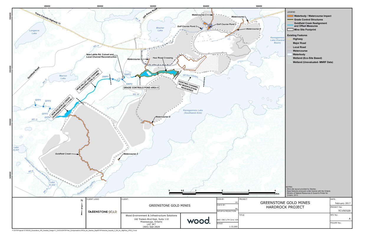
Source: Wood (formerly Amec Foster Wheeler), February 2017
Description of the Existing Environment
Wetlands provide habitat for amphibians, reptiles, furbearers, waterfowl and fish that may be affected by the loss and alteration of waterbodies associated with federal decisions. As described in Table 6, the project development area contains approximately 2200 hectares of wildlife habitat, of which approximately 810 hectares are wetland habitat. Wildlife habitat in areas that would be overprinted and realigned include approximately 37 hectares of wildlife habitat, of which there is five hectares of upland, 25 hectares of wetland, four hectares of disturbed areas, and three hectares of open water habitat.
7.7.1 Changes to wetlands and alteration of hydrology
Proponent's assessment of environmental effects, mitigation and monitoring
The overprinting of waterbodies and wetlands, and the realignment of watercourses will reduce wetland catchment areas, alter surface and groundwater hydrology, and modify watercourse and wetland connectivity. The majority of wetlands impacted by the Project would be located on the shores of Kenogamisis Lake, and would experience fewer adverse effects from alterations to ground and surface water levels because the water levels of these wetlands are controlled by the lake. For wetlands and watercourses adjacent to the Goldfield Creek diversion channel, the proponent anticipates that the increase in flow with the watercourse realignment would mitigate the reduction in catchment area and groundwater drawdown associated with dewatering the open pit (Section 6.2). Predicted changes to the terrestrial landscape including wetlands are described in greater detail in Section 6.4.
The Project as a whole, including a broader suite of effects than those related to federal decisions, is predicted to result in some displacement of wildlife from the project development area to suitable adjacent habitat. This displacement is not predicted to result in measurable residual effects to wildlife populations, wildlife movement, mortality or distribution within the terrestrial biology of the regional assessment area. Adverse effects to these species that are linked to federal decisions are predicted to be minor and have not been assessed further in this section.
Mitigation measures proposed to reduce the predicted adverse effects on wetlands include minimizing the project footprint, restricting vegetation clearing to the project footprint, and minimizing the effect of vegetation clearing on adjacent habitat of importance to wetland species. A progressive rehabilitation plan and an invasive species management plan would be implemented to re-establish wetland habitat and native wetland vegetation during operations, decommissioning and abandonment of the Project, as discussed in Section 6.4. Approximately 404 hectares of wetland and open water habitat are predicted to be rehabilitated within the tailings management facility, Goldfield Creek diversion channel, water management facilities, and other disturbed areas, and rehabilitation will begin where possible during operations.
In addition, the fish habitat offset plan, as required pursuant to the Fisheries Act Footnote 51 for watercourse realignments, would include mitigation measures for the features and functions of the present watercourses, including wetlands. The progressive rehabilitation of wetlands would also be part of monitoring program required under the fish habitat offset plan.
Views Expressed
Animbiigoo Zaagi'igan Anishinaabek, Aroland First Nation and Ginoogaming First Nation requested further information on wetland rehabilitation along the Goldfield Creek diversion channel, and involvement in the groundwater and surface water monitoring. They expressed concern with the proponent's plan to convert organic wetlands (e.g., fens and bogs) to mineral wetlands (e.g., marsh and swamps) during rehabilitation. The proponent provided a proposed progressive rehabilitation plan and committed to funding environmental monitors from Animbiigoo Zaagi'igan Anishinaabek, Aroland First Nation and Ginoogaming First Nation. The proponent noted that the rehabilitation of wetlands is not required to avoid significant effects to wildlife and vegetation.
Agency Analysis and Conclusion
The Agency is of the view that, after taking into consideration the implementation of mitigation measures, the Project would likely not have a significant effect on wetlands that are directly linked or necessarily incidental to federal decisions that may be required for the Project.
The Agency considered the direct loss of organic and mineral wetlands within the project development area, and the indirect wetland loss within the biophysical local assessment area due to changes in surface and groundwater levels. In addition, the Agency notes that the loss of wetland habitat, particularly organic wetland habitat, will affect the ecosystem function including habitat for flora and fauna, food abatement, groundwater recharge, nutrient retention and contaminant filtration within the local assessment area. However, a fish habitat offset plan (Box 7.1-1), progressive site rehabilitation plan (Box 7.2-1) and an invasive species management plan (Box 7.3-1) would be implemented, which would include the rehabilitation of wetlands. Consequently, the effect of the Project on wetland habitat is considered partially reversible. The monitoring required under the fish habitat offset plan includes monitoring of progressive rehabilitation of wetlands, and this is captured as part of the follow-up program for migratory birds in Box 7.2-2.
Given the proposed mitigation measures and the definitions of the environmental effects rating criteria in Appendix A, the magnitude of wetland loss is rated as moderate, as the residual effects to the abundance and distribution of wetlands within the local and regional assessment area are well within the predicted adaptive capability of wetland ecosystems to be self-sustaining. The geographic extent would be moderate, as the habitat loss and alterations to habitat quality and function will extend to the local assessment area. The duration of wetland loss would be long-term and of continuous frequency, with effects extending into abandonment and beyond. The effects would be considered partially reversible, due to the rehabilitation of the wetlands.
8 Other Effects Considered
8.1 Effects of the Project on Species at Risk
Subsection 79(2) of the Species at Risk Act requires the Agency to identify if and how a project is likely to adversely affect wildlife species listed in Schedule 1 of the Species at Risk Act or associated critical habitat. This requires the Agency to ensure measures are taken to avoid or lessen adverse effects on species at risk, and that appropriate monitoring and follow-up programs are considered if a project is carried out. The measures must be consistent with applicable recovery strategies and action plans.
The Agency is of the view that the Project is not likely to cause adverse effects on species at risk, after taking into account key mitigation measures and monitoring programs described for migratory in Section 7.2 and for Indigenous use in Section 7.3.
The Agency's conclusions are based on its analysis of the proponent's assessments as well as the views expressed by Environment and Climate Change Canada, the Ontario Ministry of Natural Resources and Forestry, and Indigenous groups.
For the purpose of this assessment, the Agency defined species at risk as species listed in Schedule 1 of the Species at Risk Act or assessed as endangered, threatened or of special concern by the Committee on the Status of Endangered Wildlife in Canada.
Proponent's assessment of environmental effects, mitigation and monitoring
Nine species at risk were identified within the regional assessment area (Table 10). Seven migratory bird species and two mammals were identified. There were no identified federal fish or plant species at risk predicted to be affected by the Project. The assessment in this section is focussed on direct and indirect habitat loss. Effects on migratory bird species at risk are discussed in Section 7.2.
|
Species |
Observed in LAA/PDA |
Status |
||
|---|---|---|---|---|
|
Common Name |
Scientific Name |
SARA (Schedule 1) |
COSEWIC |
|
|
PDA = project development area; LAA = local assessment area SARA = Species at Risk Act; COSEWIC = Committee on the Status of Endangered Wildlife in Canada 1 As defined by the Migratory Bird Convention Act (1994) |
||||
|
Birds (all of these species are migratory birds1) |
||||
|
Bank Swallow |
Riparia riparia |
PDA, LAA |
Threatened |
Threatened |
|
Barn Swallow |
Hirundo rustica |
PDA, LAA |
Threatened |
Threatened |
|
Canada Warbler |
Cardellina canadensis |
PDA, LAA |
Threatened |
Threatened |
|
Common Nighthawk |
Chordeiles minor |
PDA, LAA |
Threatened |
Special Concern |
|
Eastern Whip-poor-will |
Antrostomus vociferous |
LAA |
Threatened |
Threatened |
|
Eastern Wood-pewee |
Contopus vierns |
PDA, LAA |
Special Concern |
Special Concern |
|
Olive-sided Flycatcher |
Contopus cooperi |
PDA, LAA |
Threatened |
Special Concern |
|
Mammals |
||||
|
Little Brown Myotis |
Myotis lucifugus |
PDA, LAA |
Endangered |
Endangered |
|
Northern Myotis |
Myotis septentrionalis |
PDA, LAA |
Endangered |
Endangered |
Little Brown Myotis (Myotis lucifugus) and Northern Myotis (Myotis septentrionalis) overwinter in cold and humid hibernacula such as caves or mine entrances Footnote 52. Little Brown Myotis establish summer maternity colonies in buildings or large diameter trees, and forage over waterbodies, watercourses, forest edges and forest gaps. Northern Myotis rarely occupy anthropogenic structures for roosting, preferring large trees, and forage in forest gaps.
Little Brown Myotis and Northern Myotis were recorded foraging within the project development area and local assessment area, however overwintering hibernacula and maternity roosts were not identified. Maternity sites (trees, rock crevices, buildings, bat houses) and hibernacula (cave, mine or buildings) are the main limiting habitat features for Little Brown Myotis and Northern Myotis Footnote 53.
During construction, approximately 268 hectares of potential habitat would be cleared within the project development area and an additional 155 hectares of potential habitat in the local assessment area would be altered due to noise and dust generation, resulting in displacement to the local or regional assessment areas for foraging and roosting during construction, operation and decommissioning.
To reduce the predicted adverse effects of the Project, habitat loss would be restricted, by minimizing the size of the project development area. In addition, a progressive rehabilitation plan would be implemented to revegetate cleared areas during operations, decommissioning and abandonment of the Project, as discussed in Sections 6.4 and 7.2. Approximately 93 percent of the potential maternity roost habitat lost during project activities will be rehabilitated during decommissioning, with a final loss of 0.1 percent of natural bat maternity roost habitat within the regional assessment area during abandonment.
Construction of the Project will also remove existing buildings in the project development area that provide potential anthropogenic bat maternity roost habitat. Significant effect on Little Brown Myotis and Northern Myotis is unlikely because there are buildings present within the regional assessment area that may provide potential anthropogenic bat maternity roost habitat.
Views Expressed
Aroland First Nation requested the proponent complete additional species at risk surveys in the Goldfield Creek and Southwest Arm Tributary areas, and additional Little Brown Myotis and Northern Myotis roosting surveys in the project development area and local assessment area. The proponent completed additional wildlife surveys and indicated that the Goldfield Creek and Southwest Arm Tributary areas are potential nesting turtle overwintering areas. Further, a single observation of Little Brown Myotis along Goldfield Creek, was recorded.
Environment and Climate Change Canada raised concerns that the drawdown in the underground workings may inadvertently create wintering habitat for the Little Brown Myotis and Northern Myotis that would be destroyed by the eventual re-flooding of the underground workings. The proponent committed to ensuring all of these openings would be closed before the drawdown begins.
Agency Analysis and Conclusion
The Agency has determined that the measures the proponent would implement and key mitigation measures described in Section 7.2 to reduce adverse effects on migratory birds, would also reduce adverse effects on Little Brown Myotis and Northern Myotis, and on their recovery. The Agency also recommends the proponent consider applicable recovery strategies and action plans for species at risk that may be affected by the Project as outlined under the Species at Risk Act, to reduce or prevent the decline of these species53. The removal of Little Brown Myotis and Northern Myotis foraging habitat and potential natural bat maternity roost habitat may result in harm or mortality for Little Brown Myotis and Northern Myotis.
8.2 Effects of Accidents and Malfunctions
There is the potential for accidents and malfunctions to occur throughout all phases of the Project, which could lead to adverse impacts on the Project and its surrounding environment. The proponent has described the potential effects of project-related accidents and malfunctions, as well as their corresponding preventative and response measures. The accidents and malfunctions examined by the proponent include tailings management facility dam failure, waste rock storage area slope failure, historical tailings failure, and Goldfield Creek diversion channel failure.
The proponent has committed to develop and implement an emergency response plan that outlines the measures to be taken in the case of environmental, safety, security, and medical emergencies. This plan would contain communication measures to notify federal and provincial authorities, Indigenous groups, and the public.
Proponent's Assessment of environmental effects, mitigation and monitoring
Tailings Management Facility dam failure
A worst-case scenario regarding a tailings management facility dam failure is a full breach of the dam, late in operations, releasing a portion of the tailings solids and the full liquid contents. Three possible breach positions may occur: at the west or north dam of the north cell, or at the southwest of the south cell.
A failure at the west or north dam of the north cell would increase flows into the Goldfield Creek diversion channel or downstream connected watercourses, including the shoreline of the Southwest Arm of Kenogamisis Lake. A failure at the southwest dam of the south cell would flow along the Goldfield Creek Tributary to the upstream end of Kenogamisis Lake, but other portions of the project development area would not flood beyond what is typical for a large precipitation event. Kenogamisis Lake would experience minimal water level increases beyond typical precipitation flooding.
In case of a dam failure, regardless of breach position, deterioration in water quality, along with sediment deposition, would cause short-term effects such as fish toxicity and unsuitable spawning habitats due to smothering by solid tailings, and long-term effects such as fish mortality due to food shortage or chronic toxicity. These effects could extend beyond the local assessment area for fish and fish habitat, and would likely be irreversible.
Local vegetation communities may be covered by tailings solids. Localized loss of wildlife and migratory bird habitat could occur near the tailings management facility, particularly at the location of the breach. This loss could extend to the local assessment area. Adverse effects on migratory birds, wildlife and their habitats would be medium-term to long-term, and potentially irreversible.
Access to lands for Indigenous use may be impeded following a dam breach. This restriction may affect navigation on watercourses. These effects are expected to be limited to the local assessment area, medium-term to long-term, and potentially irreversible.
The initial response to a dam failure would include the following:
- halt the pumping of tailings to the tailings management facility;
- notify authorities, emergency responders, local residents and local Indigenous groups;
- initiate the pumping of tailings water to the open pit if it is needed;
- deploy turbidity curtains in the affected watercourses;
- deploy earthwork equipment for dam repairs and establishing additional containment as required; and
- develop a remedial action and monitoring plan specific to the event.
Several design measures have been committed to ensure the safety and stability of the tailings management facility. Containment structures will be constructed and designed in accordance with the Canadian Dam Association's Dam Safety Guidelines Footnote 54 and Application of Dam Safety Guidelines to Mining Dams Footnote 55, along with requirements of Ontario Ministry of Natural Resources and Forestry or the Ontario Ministry of Energy, Northern Development and Mines, as applicable.Footnote 56 The tailings dam would be designed to contain the 1-in-100-year storm event without discharge, would have an emergency overspill exit to discharge larger storm events, and would withstand the maximum credible earthquake in the geographic region. Rockfill embankments would be used for the perimeter of the dams, so that the stability of the dam does not rely on deposited tailings. The perimeter design will also take advantage of the natural topography in the Project site in order to contain tailings while reducing dam length and height.
Other proponent commitments include:
- create an Independent Tailings Review Board composed of industry experts to review the designs and the monitoring data;
- inspect for quality assurance during construction of the tailings management facility;
- develop an Operation, Maintenance and Surveillance Manual to facilitate training and proper inspection;
- perform annual dam safety inspections by a qualified geotechnical engineer; and
- implement dam instrumentation to monitor of the condition of the dams.
Waste rock storage area slope failure
A large-scale failure of a waste rock storage area slope could release waste rock into the open pit, the Southwest Arm of Kenogamisis Lake, or the Southwest Arm Tributary. The slopes will be designed for stability and monitored, so that the risk of slope failure would be low. A large-scale slope failure may cause waste material to enter the local assessment area, which would affect surface water, fish and fish habitat, and Indigenous use. A slope failure into the pit lake, during or after filling with water, may result in full mixing of the pit lake. Stratified conditions in the pit lake would be expected to re-establish within a year after a failure. Effects from the failure would be localized, short-term, and reversible. The initial response in this scenario would be to stop work in the area, develop a specific response plan, and to clear the released material to the greatest extent possible.
Historical tailings failure
The failure of the unexcavated historical MacLeod tailings could cause localized collapsing and exposure of these tailings. Contents would be released, of which arsenic is of most concern, into the surrounding environment. The initial response to a loss of this stability would be to stop work and secure the area, notify local residents, Indigenous groups, and emergency responders. The historical tailings would be contained, remediated, monitored, and investigated to reduce the likelihood of recurrence. Excavation would be required in the case of a subsequent failure. Effects on water quality, fish and fish habitat, and Indigenous use would be localized. These effects may be long-term and potentially irreversible, due to cumulative effects from seepage of the historical tailings.
Goldfield Creek diversion channel failure
A Goldfield Creek diversion channel failure would only be expected in the case of an extreme precipitation event. As a preventative design measure, a natural channel design would be used to create a diversion channel most appropriate for the surrounding environment and climate, to accommodate a high flow peak due to a 1-in-100-year, 24-hour rainfall event without overtopping the diversion dam located north of the tailings management facility. Risks to the diversion channel includes the erosion of the diversion dam of the tailings management facility and the potential of mixing of contact water with the water contained in Pond M1. In the case of a breach, repairs would be done and offsetting measures would be implemented as needed. Effects could span over several hundred metres of the channel, and could cause sedimentation to the Southwest Arm Tributary and possibly the Southwest Arm of Kenogamisis Lake. Localized effects on surface water and fish and fish habitat are possible. These effects would be expected to be short-term and reversible.
Views expressed
Animbiigoo Zaagi'igan Anishinaabek, Aroland First Nation, Ginoogaming First Nation, Long Lake #58 First Nation, and Métis Nation of Ontario raised concerns regarding the response to a tailings management facility dam breach by the proponent, the potential environmental effects of a tailings dam failure, and the possibility of having Indigenous groups involved in the monitoring process. The proponent indicated that the probability for a dam breach to occur is low, and that if such a failure were to occur, the environmental effects could be numerous but particularly significant in aquatic habitats in the flood path. The proponent noted that the Emergency Response Plan would involve notification to local Indigenous groups that use the affected lands and waters, as well as consultation for a remediation plan. Monitoring of the tailings management facility dam would occur to avoid a catastrophic instance, and design preventative measures would be taken to add extra support to the tailings management facility. The Emergency Response Plan and other monitoring plans have been refined and include Indigenous consultation.
Environment and Climate Change Canada, Ontario Ministry of Natural Resources and Forestry and Ontario Ministry of Energy, Northern Development and Mines raised concerns that the effects of a failure of the tailings management facility could potentially be severe, long-term and potentially irreversible, due to large scale amount of tailings input into the Southwest Arm of Kenogamisis Lake and its depth. These departments also acknowledge that the risk of this accident is remote, and is further reduced by the proponent's commitment to create an Independent Tailings Review Board with industry experts to review the design and monitoring data.
Agency Analysis and Conclusion
The Agency is of the view that the proponent has appropriately identified and assessed potential accidents and malfunctions associated with the Project. The proponent took the risks of accidents and malfunctions into account in the design of the Project to minimize the likelihood of a tailings management facility dam failure. The Agency further notes the proponent identified preventive and response measures, which would be outlined in the Emergency Response Plan. While a tailings management facility dam failure could cause significant adverse effects on aquatic habitat, the Agency notes that the probability of such an event occurring would be low, given the preventive measures that the proponent has committed to implement. The Agency acknowledges that the proponent's creation of an Independent Tailings Review Board composed of industry experts to review the construction designs and monitoring data would further reduce the likelihood of a tailings management facility dam failure.
The Agency has considered the measures proposed by the proponent and comments received from Indigenous groups, and concludes that the Project is not likely to result in significant adverse environmental effects as a result of accidents and malfunctions.
8.3 Effects of the Environment on the Project
Pursuant to paragraph 19(1)(h) of CEAA 2012, the environmental assessment must take into account any change to the Project that may be caused by the environment, including extreme and periodic weather events. Several environmental factors that could have an effect on the Project, including: climate, climate change, seismic events and landslides, and forest fires. These factors may damage project components and increase the potential for accidents and malfunctions (Section 8.2).
Proponent's assessment of environmental effects
Climate
Extreme temperatures and severe precipitation, fog and visibility, winds and extreme weather events could potentially cause delays in project activities and delivery of material, damage to project components, and increased structural loading. Drought conditions could lead to increased dust in the project development area, reduced water availability to meet water demand in the mill from the tailings management facility, and reduced freshwater availability from the Southwest Arm of Kenogamisis Lake. Reduced water availability could be offset by increased dewatering of the historical underground workings and the open pit. Extreme precipitation could lead to flooding and erosion; facilities would be designed to handle excess water in extreme weather events.
Ice jams also have the potential to occur within the water containment structures. These jams could cause flooding to the surrounding environment and damage to project components. To mitigate this, the pump inlet level for reclaim water to the mill would always be maintained below the level of ice formation. Submersible pumps will circulate the relatively warmer waters from deeper depths of the tailings pond. Ice cutters or breakers would be deployed, if required.
Climate Change
Climate change predictions for the project development area suggest an increased frequency and magnitude of extreme weather events, increased flooding and erosion, and increased temperatures which would lead to more frequent forest fires. Similar to the effects of climate on the Project, climate change effects could cause delays in project activities and delivery of material, damage to project components, and increased structural loading. Compliance with design and building codes and standards is expected to account for weather extremes, through built-in factors of safety to prevent undue damage to infrastructure from such events. The designs considered the occurrence of the Timmins Storm Footnote 57, which exceeds the 1-in-500-year storm design criteria recommended by the Ontario Ministry of the Environment, Conservation and Parks to address climate change.
Seismic activity and Landslides
The Project is considered to have a low susceptibility for seismic activity, due to the low frequency of earthquakes in the project development area. The Project area also lies in a region with low susceptibility to landslides. However, to minimize the likelihood of seismic-induced damage to project components, the design, construction and monitoring of dams, structures and buildings would be undertaken in accordance with the appropriate seismic codes, guidelines and standards.
Forest Fires
During dry conditions, a forest fire could potentially spread to the project development area, igniting fuel and other flammable materials and causing explosions, and loss of habitat created during progressive rehabilitation. To minimize the likelihood of forest fires spreading onto the site, flammable debris within 30 metres of project components will be cleared. Trained firefighting staff would be available to respond to a fire.
Agency Analysis and Conclusion
The Agency is of the view that it is unlikely that the environment would cause effects on the Project that would result in significant adverse environmental effects. The Agency is satisfied that the proponent has adequately considered the effects of the environment on the Project and that the proposed preventive measures, mitigation measures and response measures are appropriate to account for the potential effects of the environment on the Project.
8.4 Cumulative Environmental Effects
Cumulative environmental effects are defined as the effects of a Project that are likely to result when a residual effect acts in combination with the effects of other projects or activities that have been or would be carried out. The cumulative effects assessment was guided by the Agency's Operational Policy Statement – Assessing Cumulative Environmental Effects under the Canadian Environmental Assessment Act, 2012 Footnote 58. Under CEAA 2012, the "environmental effects" to be considered for the cumulative effects analysis are those in areas of federal jurisdiction as described in section 5 of the CEAA 2012. For the Project, the Agency specifically focused its analysis on:
- migratory birds, and
- current use of lands and resources for traditional purposes (Indigenous use).
In sections 7.2 and 7.3, the Agency concluded that the effects of the Project on these two valued components are not significant, taking into account the key mitigation measures and follow-up programs. Although these effects are not significant, they can be combined with the effects of other past, present and future physical activities.
The Agency is of the view that the Project, in combination with past, present and reasonably foreseeable projects, is not likely to cause significant adverse cumulative environmental effects and that no additional mitigation or follow-up program measures are required. In making this determination, the Agency considered the project effects, views expressed by federal departments, provincial ministries, Indigenous groups and the public, and proposed mitigation measures (Chapter 7), as well as the effects of other projects and the existing federal and provincial regulatory regimes.
Proponent's Approach and Scope
Past, existing, and reasonably foreseeable projects that could interact with the Project were included in the cumulative effects assessment. The projects and activities included in the assessment were related to mining, forestry, infrastructure, and municipal development. Figure 14 shows their locations in relation to the Project. Physical activities are retained for the assessment based on the interaction potential for environmental effects of those and the Project, and listed in Table 11. The potential interactions of project effects was assessed, taking into account the geographic extent, duration and timing of the effects. The proponent's assessment also considered existing regulatory regimes that influence how projects are managed.

Source: Stantec, September 2018
|
Physical Activity |
Distance to the Project |
Description |
Potential interactions with the Project |
|---|---|---|---|
|
Bankfield West Exploration |
10 kilometres east of the Project |
An exploration drill program, in the Bankfield West target area, to confirm the occurrence of mineralization. |
Changes to air quality, vegetation communities, wildlife and wildlife habitat, and Indigenous use. |
|
Proposed Geraldton subdivision |
Two kilometres northwest of the Project |
Development for a rural residential subdivision on the south shore of Kenogamisis Lake (Barton Bay) west of Little Longlac. |
Changes to air quality, vegetation communities, wildlife and wildlife habitat, and Indigenous use. |
|
Municipality of Greenstone Landfill |
Undetermined but within the Municipality of Greenstone boundary |
The Municipality's landfill site in Geraldton Ward is approaching capacity and a review of alternative options for municipal solid waste management within the Municipality is being undertaken. |
Changes to air quality and Indigenous use. |
|
Union Gas Pipeline |
Approximately five kilometres north of the Project |
Construction of approximately 10 kilometres of new natural gas pipeline from a TransCanada line to the Project. |
Changes to vegetation communities, wildlife and wildlife habitat, and Indigenous use. |
|
TransCanada Energy East Project Footnote 60 |
10 kilometres north of the Project |
In northern Ontario, the segment will require converting an existing natural gas pipeline to an oil transportation pipeline and constructing the associated facilities and pump stations. |
Changes to vegetation communities, wildlife and wildlife habitat, and Indigenous use. |
|
Ministry of Natural Resources and Forestry – Forestry Management Unit 815 – Lake Nipigon Forest |
10 kilometres west of the Project |
Encompasses 1.26 million hectares of Crown managed land. The Forest is situated in the Boreal Forest Region. |
Changes to vegetation communities, wildlife and wildlife habitat, and Indigenous use. |
|
Ministry of Natural Resources and Forestry – Forestry Management Unit 350 – Kenogami Forest |
Project development area within the management unit |
Encompasses 1.9 million hectares of northern Ontario boreal forest. |
Changes to vegetation communities, wildlife and wildlife habitat, and Indigenous use. |
8.4.1 Migratory Birds
Proponent's Assessment of Environmental Effects, and Proposed Mitigation and Monitoring
The Project in combination with five future physical activities (Bankfield West Mineral Exploration, forestry activity, proposed Geraldton Subdivision, TransCanada Energy East Project and Union Gas Pipeline) would result in the removal of migratory bird habitat within the regional assessment area. The effects from the Project are detailed in Section 7.2.2. Similar migratory bird habitat would remain available elsewhere in the regional assessment area, and the majority of habitat loss would regenerate after the forestry harvesting activities.
Approximately two percent of the non-treed wetland bird breeding habitat and five percent of waterfowl nesting habitat within the regional assessment area (Figure 5, approximately 168 300 hectares) would be removed due to cumulative effects from the Project and the above named future physical activities. The majority of this direct loss is attributable to the Project and forestry harvesting; however the loss associated with forestry activities is considered conservative because provincial legislation Footnote 61 and guidelines Footnote 62 limit operational forestry activities adjacent to wetlands. In addition, a portion of suitable non-treed wetland habitat and waterfowl nesting habitat would re-establish over time as the terrestrial vegetation regenerates.
Approximately 11 percent of Canada Warbler breeding habitat and 15 percent of Eastern Wood-pewee breeding habitat within the regional assessment area would be removed due to the Project and the named future physical activities. The majority of suitable upland forest and treed wetland breeding habitat would re-establish over several decades as post-logging succession and mine rehabilitation progresses. As noted in Table 8, less than two percent of available habitat of Canada Warbler and Eastern Wood-pewee habitat in the regional assessment area would be permanently lost due to the Project and Geraldton Subdivision.
The Project and the named future physical activities, except for the proposed Geraldton subdivision, would result in the direct loss of 33 percent of Common Nighthawk breeding habitat within the regional assessment area. The majority of habitat loss is attributable to the Project and the pipeline developments. Common Nighthawk habitat is underrepresented within the ecosite mapping and, consequently, the estimated loss from future physical activities may be overestimated. Further, future physical activities within the regional assessment area may create suitable nesting habitat for this species during revegetation of the disturbed sites.
The implementation of mitigation and follow-up program measures described in Section 7.2 would minimize the Project's contribution to the cumulative environmental effects from habitat loss. No additional mitigation measures are proposed to reduce cumulative effects to migratory birds.
Agency Analysis and Conclusion
The Agency is of the view that, after taking into consideration the implementation of mitigation measures (Box 7.2-1) and the recommended follow-up program measures (Box 7.2-2), and in combination with existing and reasonably foreseeable projects or activities, the Project is not likely to cause significant cumulative effects on migratory birds.
The Agency notes that provincial forestry management practices take into consideration all terrestrial values including conservation of biodiversity and enhancement or protection of wildlife habitat and watersheds. The Agency also acknowledges that the provincial forestry management process sets objectives for indicator species prior to determining areas where timber harvest is permitted, and factors in the implication of private lands, mining activities, locations of natural resource features, and land uses and values of interest to Indigenous people. The Agency notes that cumulative effects on habitat loss of migratory birds would be partially reversible as habitat removed by forestry activities would be regenerated over time. Therefore, the Agency is of the view that no further mitigation or follow-up program measures are required for the Project.
8.4.2 Current use of lands and resources for traditional purposes
Proponent's Assessment of Environmental Effects, and Proposed Mitigation and Monitoring
The Project in combination with five future physical activities (Bankfield West Mineral Exploration, forestry activity, proposed Geraldton Subdivision, TransCanada Energy East Project and the Union Gas Pipeline) would cumulatively result in terrestrial and wildlife habitat loss within the regional assessment area. As discussed in Section 8.4.1, similar upland and wetland habitat would remain available elsewhere in the regional assessment area, and the majority of habitat loss would regenerate after the forestry harvesting activities.
Cumulative effects on Indigenous use from availability of wildlife may occur as a result of residual effects from habitat loss and fragmentation, leading to wildlife mortality and population displacement. Past physical activities have significantly modified the landscape within the regional assessment area, and while it is unlikely to have affected the sustainability of most wildlife species within the regional assessment area, present and future physical activities will contribute to additional wildlife habitat loss. Moose populations have declined within the regional assessment area in response to a number of factors including hunting, predation, parasites and habitat conditions. Approximately 7450 hectares of moose foraging habitat and approximately 6938 hectares of moose late winter cover would be removed due to future physical activities, which is a total of approximately two percent of the regional assessment area for Indigenous use (Figure 3, approximately 785 400 hectares). Moose displaced by future physical activities are likely to find foraging habitat and late winter cover elsewhere in the regional assessment area. In addition, it is expected that moose foraging habitat and late winter cover would revegetate after forestry activities.
The risk of wildlife mortality associated with cumulative effects in the regional assessment area would increase, with additional persistent sources of mortality risk (e.g., highway vehicle traffic) and short-term, intermittent sources (e.g., forest harvesting, site clearing activities), however, it is not predicted to have an effect on the long-term persistence or viability of wildlife species within the regional assessment area.
The Project in combination with three future physical activities (Bankfield West Exploration Project, proposed Geraldton subdivision and the Municipality of Greenstone landfill) would cumulatively result in changes to air quality. Changes to air quality may result in reduction of quality of experience during Indigenous use (Section 7.3.3). All of the named future physical activities are located within the regional assessment area for Indigenous use, and are all expected to meet applicable air quality standards during their operations. As discussed in Section 6.1.1, the Project's contribution to air quality will be above baseline conditions but mostly within applicable air quality standards for all contaminants, with the exception of infrequent exceedances of PM10 and PM2.5 in the local assessment area. The cumulative effects on air quality are not predicted to further deteriorate the quality of experience within the regional assessment area.
The implementation of mitigation measures and follow-up programs described in Sections 7.2 and 7.3 would minimize the Project's contribution to the cumulative environmental effects. No additional mitigation measures are proposed to reduce cumulative effects to Indigenous use from changes to air quality or wildlife habitat.
Views Expressed
Animbiigoo Zaagi'igan Anishinaabek, Aroland First Nation and Ginoogaming First Nation requested that other known deposits within the Trans-Canada property owned by Greenstone Gold Mines, including the Brookbank and Viper mining deposits, be assessed as reasonably foreseeable physical activities in the cumulative effects assessment, as the deposits are discussed by the proponent in documents to investors and on the proponent's website. The Indigenous groups also raised concerns that these proposed physical activities may use components from the Project in order to make the Project more financially viable, and that use would not be accounted for in the cumulative effects assessment. The proponent indicated that the Brookbank and Viper physical activities were considered "past and present activities" as exploration work has been conducted, and its effects are already captured as part of the baseline conditions. The proponent added that there are no current plans for development of these deposits, and that the Project is viable and being planned without use for other deposits that it owns near the Project.
Animbiigoo Zaagi'igan Anishinaabek, Aroland First Nation, and Ginoogaming First Nation expressed concern regarding the cumulative effect of moose habitat loss on moose populations given the declining calf recruitment trends and lower ecological density estimates in the Project area. They requested that the proponent implement a moose monitoring program. The proponent indicated that the wildlife habitats are common and widespread in the regional assessment area, the habitat loss from the Project has been minimized through Project design, and the Project and other reasonable foreseeable physical activities will not affect the long-term persistence or viability of moose. The proponent also noted that because of the large home ranges of moose, moose populations are monitored and managed on a landscape scale by the Ontario Ministry of Natural Resources and Forestry, not by private proponents.
Agency Analysis and Conclusion
The Agency is of the view that, after taking into consideration the implementation of mitigation measures and the recommended follow-up programs for Project effects (Boxes 7.2-1, 7.2-2, 7.3-1 and 7.3-2), and in combination with existing and reasonably foreseeable projects or activities, the Project is not likely to cause significant cumulative effects on Indigenous use.
The Agency notes that Project contributions to cumulative effects on terrestrial and wildlife habitat would involve localized effects from the Project, as described in Sections 6.4, 7.2 and 7.3. As noted in Section 7.3.1, the Agency is of the view that quality of resources for Indigenous use is abundant in the regional assessment area. The Agency is satisfied that the overall moose habitat loss (approximately two percent) in the regional assessment area, would still allow continued use elsewhere in the regional assessment area. The Agency notes that any impacts due to habitat loss are reversible as the habitat would begin to re-establish soon after project rehabilitation.
The Agency considered the concerns raised by Indigenous groups that cumulative effects from mining at the proposed Brookbank and Viper deposits should be considered in the cumulative effects assessment, particularly where components from the Project would be used for those physical activities. The Agency agrees that these physical activities would not be considered certain or reasonably foreseeable under the Agency's Operating Policy Statement, and would not be in scope for the cumulative effects assessment. The Agency notes that the proponent has committed to providing the Indigenous groups with any future plans to develop other deposits owned by the proponent in the region. The Agency also notes that, if the Project is permitted to proceed by the Minister of Environment and Climate Change, prior to initiating any change to the Project that may result in adverse environmental effects, the proponent would be required to provide the Agency with a description of the potential adverse environmental effects of the proposed changes to the Project, along with the mitigation measures and follow-up program measures proposed to be implemented by the Proponent. This would include a requirement that the proponent consult with Indigenous groups, and provide the Agency with the results of the consultation with Indigenous groups.
Therefore, the Agency is of the view that no further mitigation or follow-up program measures are required for the Project.
9 Impacts on Aboriginal or Treaty Rights
In alignment with the Agency's overall approach to consultation and the Updated Guidelines for Federal Officials to Fulfill the Duty to Consult (March 2011), the Agency sought information from all potentially impacted Indigenous groups about the nature of their Aboriginal and treaty rights protected under section 35 of the Constitution Act, 1982 Footnote 63 (Aboriginal and treaty rights) and how they may be impacted by the Project. The Agency considered any new information arising from the proponent about the potential impacts of the Project, as they emerged, in an effort to better understand the nature, scope and extent of adverse impacts on rights. Where potential impacts on Aboriginal and treaty rights were identified, the Agency took into account the appropriate mitigation measures before determining the severity of the impacts.
This section summarizes how the Project may impact Aboriginal and treaty rights. Appendix D summarizes all issues of concern identified by Indigenous groups.
9.1 Existing Aboriginal and Treaty Rights
The Project is located within the Treaty 9 (1905-1906) area of Ontario (Figure 12), which affords protections that include hunting, trapping and fishing throughout the treaty territory. Other traditional uses of the lands and resources, which are Aboriginal rights protected in section 35 of the Constitution Act, 1982, include trapping, plant harvesting, and the use of lands and resources for cultural purposes.Footnote 64. The Project is also approximately 13 kilometres from the boundary with the Robinson-Superior Treaty (1850) area (Figure 12), which affords protections that include hunting and fishing practices for Indigenous people.
The Project is located within an area identified by the Métis Nation of Ontario as Lakehead/Nipigon /Michipicoten Region 2 traditional harvesting area. The Métis have been successful in establishing Métis rights through the R. v. Powley (2003) Supreme Court decision. The Métis also hold Aboriginal rights which are protected under section 35 of the Constitution Act, 1982. The Métis Nation of Ontario indicated that numerous Métis citizens represented by them live, and harvest within or extensively use the area. Red Sky Métis Independent Nation citizens, who live in communities throughout the Robinson-Superior Treaty area and assert that they are descendants of 84 Métis beneficiaries of this treaty, have also identified parts of the Treaty 9 area as traditional land used by the Red Sky Métis Independent Nation community.
Fourteen Indigenous groups have been identified for consultation for the Project, five of which are signatories to Treaty 9, seven of which are signatories to the Robinson Superior Treaty and two Métis groups.
The Project has the potential to cause adverse environmental effects (Chapters 6 and 7), which may also lead to adverse impacts on Aboriginal and treaty rights related to the practice of fishing, hunting, trapping, and plant harvesting, as well as Indigenous groups' cultural practices. Members from Aroland First Nation and Ginoogaming First Nation (signatories to Treaty 9), Animbiigoo Zaagi'igan Anishinaabek and Long Lake #58 First Nation (signatories to the Robinson-Superior Treaty), and the Métis Nation of Ontario, would be most likely to be directly impacted due to proximity of the Project to their current and traditional land use and practice of rights. Potential impacts include overprinting by project components of sites for harvesting plants, hunting, trapping, fishing, teaching and cultural connection to the land, in addition to indirect effects such as diminished experience while using the land. These particular impacts on Aboriginal and treaty rights are discussed below.
9.2 Potential adverse impacts of the Project on Aboriginal and Treaty Rights
Proponent's Views
The proponent provided information about the treaties in the area and Indigenous use by each group. Through its assessment of Indigenous use, health, socio-economic conditions, physical and cultural heritage and description of cultural importance of activities, the proponent assessed the effects of the Project on traditional land use practices (Sections 7.3, 7.4, and 7.5). Based on these assessments, the proponent is of the view that there are no significant impacts on Aboriginal and Treaty rights from the Project based on their conclusions for effects to Indigenous use.
Hunting and trapping
Indigenous Groups' Views
Animbiigoo Zaagi'igan Anishinaabek, Aroland First Nation, Ginoogaming First Nation, Long Lake #58 First Nation and the Métis Nation of Ontario raised the importance of the project development area, local assessment area and regional assessment area for the practice of Aboriginal and treaty rights in relation to hunting and trapping. Animbiigoo Zaagi'igan Anishinaabek, Aroland First Nation and Ginoogaming First Nation highlighted the importance of the project development area for moose hunting and expressed concern about the loss of moose habitat due to overprinting by project components and loss of access due to removal of Lahtis Road.
A member of Animbiigoo Zaagi'igan Anishinaabek holds a trapline which is partially overlapped by the project development area, and members of Long Lake #58 First Nation hold three traplines located in the local assessment area. These Indigenous groups raised concerns with the ability of their members to be able to continue to use these traplines. The proponent committed to minimizing the overlap with the trapline held by the member of Animbiigoo Zaagi'igan Anishinaabek by reducing the footprint of the project development area. Further, the proponent committed to minimizing disturbances to animals, and minimizing effects on the quality of experience.
Agency's Views
While the proponent and Indigenous groups did not frame most of the comments or analysis for hunting and trapping through a rights-based perspective, the Agency did receive information, comments and analysis on the use and value of hunting and species hunted (e.g., moose, marten and waterfowl) and of importance to the Indigenous groups. Information received through the proponent's environmental impact statement, information requirements, and comments received demonstrate that the right to hunt, including trapping, could be modified through the removal of wildlife habitat (Section 7.3.1), the removal of access to hunting and trapping sites (Section 7.3.2), and disturbance to Indigenous hunters through changes to noise, air or visual landscape (Section 7.3.3). The Agency is aware of the overlap of the project development area with parts of a trapline held by Animbiigoo Zaagi'igan Anishinaabek, and three traplines held by Long Lake #58 First Nation in the local assessment area (Section 7.4.2); however the proponent has worked with the communities to minimize the footprint of the project and ensure access to traplines where they approach the project development area, in order to mitigate the potential impacts.
The proponent and Animbiigoo Zaagi'igan Anishinaabek, Aroland First Nation, Ginoogaming First Nation, and Long Lake #58 First Nation have agreed to participate in a regional moose health study led by the Ontario Ministry of Natural Resources and Forestry, and the proponent has agreed to further monitor smaller wildlife in the local assessment area. The proponent has also committed to providing unrestricted alternate access to areas of importance for hunting, specifically to the Southwest Arm of Kenogamisis Lake located near the project development area, and maintaining access to Goldfield Road to the west of the project development area. The Agency is of the view that with the proposed mitigation and given the small amount of area disturbed by the project (including sensory disturbances), the Project is expect to have a low impact on the Aboriginal and Treaty rights of Indigenous groups to hunt and trap.
Fishing
Indigenous Groups' Views
Animbiigoo Zaagi'igan Anishinaabek, Aroland First Nation, Ginoogaming First Nation, Long Lake #58 First Nation, and the Métis Nation of Ontario stated that fishing in Kenogamisis Lake and the surrounding area is an important activity and contributes to a traditional diet. Concerns were expressed about the residual environmental changes from the Project on the availability and health of the fish in Kenogamisis Lake and surrounding waterbodies. There are longstanding concerns from Indigenous groups regarding the water quality in Kenogamisis Lake and Barton Bay due to historical mining activities, leading to ongoing concerns for the Project's potential effects to water quality in surface waterbodies in the area. The Métis Nation of Ontario indicated that they are working with the proponent to establish monitoring for mercury in Kenogamisis Lake, including Barton Bay. Animbiigoo Zaagi'igan Anishinaabek, Aroland First Nation, Ginoogaming First Nation, and Long Lake #58 First Nation requested ongoing monitoring of water quality, in particular for arsenic levels, and for members of their communities to be involved in the monitoring. Long Lake #58 First Nation asked for the proponent to include a water quality monitoring station in Long Lake, given the connection of that lake to Kenogamisis Lake and its importance to its members.
Animbiigoo Zaagi'igan Anishinaabek, Aroland First Nation, and Ginoogaming First Nation raised concerns regarding potential overprinting of Begooch Zaagi'igan (Lake A-322) with the proposed tailings management facility. Through discussions with the proponent, the tailings management facility was moved to the northeast, to avoid overprinting of the lake and allow continued access and use by the Indigenous groups.
Agency's Views
The Project is not expected to have a significant effect on fish health or populations, and changes to safe consumption of fish tissue are not anticipated (Section 7.1.1). While portions of Goldfield Creek and several small watercourses would be overprinted or experience flow reductions from Project activities, the Project is not expected to have a significant effect on fish habitat (Section 7.1.2). Due to the removal of Lahtis Road access to the Southwest Arm of Kenogamisis Lake using Lahtis Road will change, however the proponent has committed to provide alternate access (Section 7.3.2). There could also be sensory disturbances to those using nearby areas or perceived changes to fish health which could deter fishers from utilizing the resource, thus limiting the practice of fishing rights (Section 7.3.3).
The proponent and Indigenous groups such as Animbiigoo Zaagi'igan Anishinaabek, Aroland First Nation, Ginoogaming First Nation, Long Lake #58 First Nation and Métis Nation of Ontario proposed appointment of Indigenous monitors as part of the Environmental Management and Monitoring Plans. The proponent has committed to extensive monitoring of surface water and fish tissue in Kenogamisis Lake and in waterbodies in the surrounding area, including up to the mouth of Long Lake. Therefore the Agency is of the view that with proposed mitigation and minimal removal of fish habitat, which will be counterbalanced through a fish habitat offset plan that would be approved by Fisheries and Oceans Canada, low impacts from the Project are expected on the Aboriginal and Treaty rights of Indigenous groups to fish.
Plant Gathering
Indigenous Groups' Views
Animbiigoo Zaagi'igan Anishinaabek, Aroland First Nation, Ginoogaming First Nation, and Métis Nation of Ontario noted the importance of plant gathering locations in the project development area, local assessment area and regional assessment area, and raised concerns with the removal of access to plant habitat in the project development area (including Lahtis Road). Several Indigenous groups also raised concerns about the spread of invasive species throughout their territories due to the increased traffic and presence of outside vehicles, and the potential use of herbicides for removal of unwanted plants. The proponent has agreed to provide an opportunity for Indigenous groups to harvest plants in the areas to be removed prior to construction, and has also agreed to measures to mitigate the spread of invasive species, and to limit the use of herbicides to localized applications when necessary.
Agency's Views
The Project will result in impacts such as the removal of habitat in the project development area (Section 6.4.1) and sensory disturbance to the Indigenous groups' ability to harvest plants (Section 7.3.3). Animbiigoo Zaagi'igan Anishinaabek, Aroland First Nation, Ginoogaming First Nation, Long Lake #58 First Nation, and Métis Nation of Ontario have indicated that they harvest plants in this area such as berries, wild rice, and medicines; however, none of the Indigenous groups raised the area as a preferred gathering location. The proponent has proposed mitigation measures allowing impacted Indigenous groups to harvest plants in the project development area prior to construction (Section 7.3.3); minimizing dust emissions (Section 6.1.1); and implementing measures to minimize invasive species entering the project development area, and avoiding the use of herbicides whenever possible (Section 6.4.2). These measures should allow Indigenous groups to continue the practice of their gathering rights throughout the local assessment area and regional assessment area. Therefore, the Agency believes that with the proposed mitigation and the abundance of plant harvesting sites elsewhere in the regional assessment area, low impacts from the Project are expected on the Aboriginal and Treaty rights of Indigenous groups to gather plants.
Overall Cultural and Spiritual Connection to the Land
Indigenous Groups' Views
Animbiigoo Zaagi'igan Anishinaabek, Aroland First Nation, Ginoogaming First Nation, Long Lake #58 First Nation, and the Métis Nation of Ontario all raised the importance of the project development area, specifically Kenogamisis Lake, as being an important place for the continuity of their Aboriginal and treaty rights. Long Lake #58 First Nation and the Métis Nation of Ontario identified cultural sites inside the project development area and on the boundary with the local assessment area. The ongoing practices of Aboriginal and treaty rights such as hunting, trapping, fishing and plant gathering are linked to teaching and knowledge transfer between elders and youth, and spiritual and cultural practices that contribute to cultural continuity.
The proponent indicated that their work to mitigate and minimize area lost in the project development area, as well as ensuring alternate access to important locations along the Southwest Arm of Kenogamisis Lake, will allow for the continued use of sites of importance and the practice of hunting, trapping, fishing and gathering rights.
Agency's Views
The Project has the potential to impact the overall cultural and spiritual connection of Indigenous people, specifically Animbiigoo Zaagi'igan Anishinaabek, Aroland First Nation, Ginoogaming First Nation, Long Lake #58 First Nation, and the Métis Nation of Ontario, to the land, and the stewardship over their territories. In addition to mitigation measures to minimize changes to the air, water, soil and wildlife, the proponent's commitment to ongoing engagement, consultation, involvement and appointment of Indigenous monitors as part of the follow-up and monitoring of potential project effects and impacts to rights will ensure that the Indigenous groups continue to be involved in the ongoing management and stewardship of Kenogamisis Lake and surrounding areas. Additionally, the commitment to allow alternate access will enable Indigenous groups to continue their practices, teachings and ultimately connections with the land. Thus, the Agency is of the view that impacts from the Project are expected to be low on the Aboriginal and Treaty rights of Indigenous groups to their cultural and spiritual connection to the land.
9.3 Issues to be addressed during the regulatory approval phase
The regulatory approval phase of the Project will include federal decisions related to areas of federal jurisdiction that may be required should the environmental assessment decision determine that the Project can proceed. These are listed in Table 1.
The federal authorities for any regulatory approvals will consult Indigenous groups, as appropriate, prior to making decisions. The Agency has submitted directly to the federal authorities the comments from Indigenous groups that were received during the environmental assessment for consideration by the authorities, as appropriate, prior to making their decisions. The decisions by the federal authorities would take into consideration the outcomes of ongoing consultation with Indigenous groups.
The Agency recognizes that the Project is subject to a provincial environmental assessment under Ontario's Environmental Assessment Act, and that several other pieces of provincial legislation and associated regulations, guidelines and policies provide for the protection of relevant aspects of both the natural and human environments. Consultation by the province, as applicable, on those authorizations will also assist Indigenous groups in addressing issues.
9.4 Agency Conclusion Regarding Impacts to Aboriginal Rights
Based on the analysis of environmental effects of the Project on Indigenous people and the related mitigation outlined in Chapter 7, as well as the potential impacts and accommodation measures discussed above, the Agency is satisfied that the potential impacts of the Project on Aboriginal or treaty rights have been adequately identified and appropriately mitigated or accommodated. The application of mitigation, accommodation measures and follow-up program measures should allow the continued practices of Aboriginal and treaty rights of Indigenous groups in a similar manner as before the Project.
The Agency recognizes that consultation is ongoing and further information regarding potential residual impacts may still be forthcoming. Input from Indigenous groups on this report and draft potential conditions will be considered and will assist the Agency is finalizing its conclusions regarding potential impacts from the project on Aboriginal and treaty rights.
10 Conclusions
In preparing this report, the Agency took into account the proponent's environmental impact statement, its responses to information requests, and the views of government agencies and Indigenous groups.
The environmental effects of the Project and their significance have been determined using assessment methods and analytical tools that reflect current accepted practices of environmental and socio-economic assessment practitioners, including consideration of potential accidents and malfunctions and the potential for cumulative effects.
The Agency concludes that, taking into account the implementation of mitigation measures, the Project is not likely to cause significant adverse environmental effects as defined in CEAA 2012.
The Agency has identified key mitigation measures and follow-up program measures for consideration by the Minister of Environment and Climate Change in establishing conditions as part of the Environmental Assessment Decision Statement, in the event that the Project is permitted to proceed. In addition, it is the Agency's expectation that for the Project to be carried out in a careful and precautionary manner, all of the proponent's commitments, as outlined in the document entitled "Addendum to the Environmental Impact Statement - Mitigation, Monitoring and Commitment List", and available on the Canadian Environmental Assessment Registry's Internet Site, would be implemented as proposed. The proponent's environmental impact statement and list of mitigation, monitoring and commitments addresses effects to valued components in areas of federal jurisdiction, as highlighted in the Report, as well as other valued components, such as labour and economy, community services, heritage resources, and impacts to MacLeod Provincial Park. The proponent concluded no significant adverse environmental effects for all valued components in their environmental impact statement.
11 Appendices
Appendix A Environmental Effects Rating Criteria
|
Assessment Criterion |
Low |
Moderate |
High |
|---|---|---|---|
|
* Timing is a valued component-specific consideration, applied to fish and fish habitat, where disturbance may occur during sensitive life stages, and for the current use of lands and resources, which may be affected seasonally by changes to the environment. |
|||
|
Magnitude |
Specific to each valued component (Table 13) |
||
|
Geographic Extent |
Site-specific, within project development area |
Local, within the local assessment area |
Regional, within the regional assessment area |
|
Duration |
Short-term or temporary, within the construction phase (<3 years) OR that occur within one generation or recovery cycle of the environmental component For current use of lands and resources for traditional purposes: effect lasts less than one complete seasonal round (<1 year) |
Medium-term, through the operation and decommissioning phases (from 3 to 20 years) OR that extend to one or two generations or recovery cycles of the environmental component For current use of lands and resources for traditional purposes: effect lasts less than one generation of land users (< 25 years) |
Long-term, into decommissioning and beyond (>20 years) OR that extend for two or more generations or recovery cycles of the environmental component For current use of lands and resources for traditional purposes: effect last for more than one generation of land users (> 25 years) |
|
Frequency |
Occurs once during any phase of the Project. |
Occurs occasionally or at intermittent intervals during any phase of the Project. |
Occurs continuously during any phase of the Project. |
|
Reversibility |
Reversible within the lifetime of the Project or at abandonment. |
Partially reversible within the lifetime of the Project or at abandonment. |
Irreversible, persisting after abandonment. |
|
Timing* |
Inconsequential, timing of predicted project activities not expected to affect sensitive activities. |
Moderate, timing of predicted project activities may affect some sensitive activities. |
Unfavourable, timing of predicted project activities will affect some sensitive activities. |
|
Ecological and Social Context |
Taken into account when considering the key criteria in relation to particular valued components, as the context may help better characterize whether adverse effects are significant. For example, information on the context is useful when it reveals:
|
||
|
Valued Component |
Rating for Magnitude |
||
|---|---|---|---|
|
Low |
Moderate |
High |
|
|
Fish and fish habitat |
Little to no effect on fish health or fish populations in the receiving environment. |
Measurable effect on fish health or fish populations in receiving environment, but would not likely result in changes to the regional status of fish populations and health. |
Measurable effect on fish health or fish populations in the receiving environment which could result in changes to the regional status of fish populations and health. |
|
Migratory birds |
Little to no effects on migratory birds or unique migratory bird habitats. |
Effect on many individual migratory birds or unique migratory bird habitats, but would not likely change the status of the regional populations or availability of unique habitats. |
Effect on the majority of migratory birds or unique migratory bird habitats which would result in changes to the status of regional populations or availability of unique habitats. |
|
Current use of lands and resources for traditional purposes |
The effect results in a change in an activity and use by an Indigenous group that could be practiced in the same or similar manner as before. |
The effect results in a change in preferred locations or means to practice the activity, and use by an Indigenous group may be modified or limited. |
The effect results in a change such that the activity can no longer be carried out by an Indigenous group in its preferred manner and locations. |
|
Health of Aboriginal peoples |
The effect results in a change to exposure that would be negligible or low and exposure does not approach health-based standards. |
The effect results in a change to exposures below but nearing health-based standards. |
The effect results in a change to exposures above health-based standards. |
|
Socio-economic conditions of Aboriginal peoples |
Negligible change in a current activity that would require little to no alteration in behaviour to carry out the activity. |
Measurable change in a current activity that would require some alteration in behaviour to carry out the activity. |
Measurable change in a current activity that would mean the activity no longer can be carried out. |
|
Physical and cultural heritage and historical and archeological sites and structures |
The effect results in a change in conditions, but the feature of physical and/or cultural heritage importance would remain relatively unchanged and activity associated with the feature and its relative value would not be affected. |
The effect results in a change in conditions, and the feature of physical and/or cultural heritage importance would be noticeably changed. Activity and use associated with the feature and its value would be affected, but use could continue. |
The feature of physical and/or cultural heritage importance would be removed, destroyed, and/or use associated with the feature would no longer continue. |
|
Transboundary effects – greenhouse gas emissions |
Emissions represent a small contribution to provincial or national emissions. |
Emissions represent a moderate contribution to provincial or national emissions but are within regulatory limits and objectives. |
Emissions cause an exceedance of provincial or national emissions objectives or standards. |
|
Valued components included under subsection 5(2): Wetlands |
No measurable residual effect to the abundance and distribution of wetlands. |
Measurable residual effect to the abundance and distribution of wetlands within the local assessment area, but the changes are well within the predicted adaptive capability of wetland ecosystems to be self-sustaining. |
Residual effect to the abundance and distribution of wetlands within the regional assessment area approaching the predicted adaptive capability of wetland ecosystems to be self-sustaining. |
|
Magnitude* |
Geographic Extent |
Duration |
Frequency |
Reversibility |
Significance |
|---|---|---|---|---|---|
|
*All effects of low magnitude were considered not significant, regardless of other criteria . |
|||||
|
Moderate |
Site-specific |
Short-term or medium-term |
Once or Intermittent |
Any Level of Reversibility |
Not Significant |
|
Continuous |
Fully or Partially Reversible |
Not Significant |
|||
|
Irreversible |
Significant |
||||
|
Long-term |
Any Level of Frequency |
Fully or Partially Reversible |
Not Significant |
||
|
Irreversible |
Significant |
||||
|
Local |
Short-term |
Once or Intermittent |
Any Level of Reversibility |
Not Significant |
|
|
Continuous |
Fully or Partially Reversible |
Not Significant |
|||
|
Irreversible |
Significant |
||||
|
Medium-term or long-term |
Once |
Any Level of Reversibility |
Not Significant |
||
|
Intermittent or Continuous |
Fully or Partially Reversible |
Not Significant |
|||
|
Irreversible |
Significant |
||||
|
Regional |
Short-term |
Once or Intermittent |
Any Level of Reversibility |
Not Significant |
|
|
Continuous |
Any Level of Reversibility |
Significant |
|||
|
Medium-term |
Once |
Any Level of Reversibility |
Not Significant |
||
|
Intermittent or Continuous |
Any Level of Reversibility |
Significant |
|||
|
Long-term |
Any Level of Frequency |
Any Level of Reversibility |
Significant |
||
|
High |
Site-specific |
Short-term or medium-term |
Any Level of Frequency |
Any Level of Reversibility |
Not Significant |
|
Long-term |
Any Level of Frequency |
Fully or Partially Reversible |
Not Significant |
||
|
Irreversible |
Significant |
||||
|
Local |
Any Duration |
Any Level of Frequency |
Fully or Partially Reversible |
Not Significant |
|
|
Irreversible |
Significant |
||||
|
Regional |
Any Duration |
Any Level of Frequency |
Any Level of Reversibility |
Significant |
|
Appendix B Summary of Environmental Effects Assessment
|
Residual Effect |
Predicted Degree of Residual Effect |
Significance of Residual Effect |
|||||
|---|---|---|---|---|---|---|---|
|
Magnitude |
Geographical Extent |
Duration |
Frequency |
Reversibility |
Timing |
||
|
Valued Component –Fish and Fish Habitat |
|||||||
|
Mortality and effects on fish health |
Low Mortality and health effects on individual fish are not expected to affect the regional status of fish populations and health |
Moderate Effect predicted to extend to the local assessment area. |
Long - term Effect predicted to extend into abandonment. |
Intermittent Effect predicted to occur at intermittent intervals during construction, operations and early part of decommissioning. |
Reversible Effect predicted to be fully reversible once project activities cease |
Moderate Timing of Project activities may affect some sensitive activities in the fish lifecycle, such as spawning. |
Not significant It is expected that there would be mortality and health effects on individual fish but populations of fish would not be affected outside of the local assessment area |
|
Fish habitat loss and alteration |
Low 7.16 hectares of fish habitat would be lost due to the Project, which would be counterbalanced by the fish habitat offset plan |
Moderate Effect predicted to extend to the local assessment area. |
Medium - term Habitats created as part of the fish habitat offset plan would be established prior to the loss of habitats, but would require time during operations to become fully established and functional. |
Continuous Effect predicted to occur continuously during construction and part of operations. |
Reversible Habitat gains expected from the created habitats through the offset plan would counterbalance any habitat losses in the long-term. |
Moderate Timing of habitat removal may affect some sensitive activities in the fish lifecycle, such as spawning. |
Not significant No net loss of habitat expected through the offset plan, pursuant to the Fisheries Act. |
|
Valued Component –Migratory Birds |
|||||||
|
Exposure to contaminants in project components with open water |
Low Given the minimal likelihood of mortality or harm to migratory birds. |
Low Effect predicted to occur within the project development area. |
Long - term Effect predicted to extend into abandonment |
Continuous Effect predicted to occur continuously during all phases of the Project. |
Reversible Effect predicted to be fully reversible once water quality meets water quality guidelines. |
N/A |
Not significant Migratory birds would avoid the project study area due to deterrents and sensory disturbance, but if present, follow-up program measures will be implemented if water quality in project components with open water exceeds predicted standards. |
|
Loss of Habitat |
Moderate Loss of suitable habitat would not result in a measurable change in the abundance of migratory birds in the project development area and the local assessment area. |
Moderate Effect predicted to extend to the local assessment area. |
Long - term Effect predicted to extend into abandonment. |
Continuous Effect predicted to occur continuously during all phases of the Project. |
Partially Reversible Effect predicted to be partially reversible as pre-project conditions would not be fully achieved. |
Moderate Timing of habitat removal may affect breeding activities of migratory birds. |
Not significant Suitable habitats are available within the local and regional assessment areas. Site rehabilitation in accordance with the provincial requirements would partially restore the project study area in the long term. |
|
Valued Component –Current Use of Lands and Resources for Traditional Purposes |
|||||||
|
Reduction of quality and availability of resources |
Low Changes to the quality and availability of resources used for gathering plants, hunting, trapping and fishing would lead to Indigenous use occurring in a similar manner to now. |
Low to Moderate Effect predicted to extend just into the local assessment area. |
Medium - term Effect predicted to occur for under 25 years (construction through decommissioning). |
Continuous Effect predicted to occur continuously during its duration. |
Partially Reversible Parts of the project development area are expected to be rehabilitated, and changes to air quality (dust) would be lessened after operations, thus reversing some of the changes to quality of plants and availability of plants, wildlife and fish for harvesting. |
N/A |
Not significant Changes in the quality and availability of resources would occur at locations in and near the project development area. Plants, wildlife and fish would be found in other parts of the local assessment area and into the regional assessment area. |
|
Loss or alteration of access for Indigenous use |
Moderate Access to Southwest Arm of Kenogamisis Lake would be maintained but modified by the Project. |
Low to Moderate Effect predicted to extend just into the local assessment area. |
Medium - term Effect predicted to occur for under 25 years (construction through decommissioning). |
Continuous Effect predicted to occur continuously during its duration. |
Partially Reversible Some access points will be re-established after decommissioning. |
N/A |
Not significant Indigenous groups would still be able to access areas along the Southwest Arm of Kenogamisis Lake including where the Goldfield Creek Tributary meets the Southwest Arm of Kenogamisis Lake, albeit with some additional travel time and distance. |
|
Reduction of overall quality of experience during Indigenous use |
Low Changes to experience should lead to Indigenous use occurring in a similar manner to now. |
Moderate Effect predicted to extend into the local assessment area. |
Long - term Effect predicted to occur for more than 25 years (construction through abandonment). |
Continuous Effect predicted to occur continuously during its duration. |
Partially Reversible Changes to air quality and noise would be reversed over time, but some changes to the visual disturbance to the land would remain. |
N/A |
Not significant Changes in the quality of experience may be found during the Project, but these would occur at locations near the project development area. Indigenous use could still occur without loss of quality of experience in other parts of the local assessment area and into the regional assessment area |
|
Valued Component –Health and Socio-Economic Conditions |
|||||||
|
Exposure to air and water contaminants by inhalation, ingestion or dermal contact |
Moderate The Project would lead to a change to exposures to water and air contaminants that are below but nearing health-based standards |
Moderate Effect predicted to extend into the local assessment area. |
Medium - term Effect predicted to occur from construction through decommissioning. |
Continuous Effect predicted to occur continuously during its duration. |
Partially Reversible Changes to air quality and water quality would be reversed over time |
N/A |
Not significant Exposure to arsenic, mercury and methylmercury from water and fish are not likely to contribute to health effects |
|
Reduced ability to harvest subsistence resources |
Moderate Harvesting activities may require some alteration in behaviour. |
Low to Moderate Effect predicted to extend just into the local assessment area. |
Medium - term Effect predicted to occur from construction through decommissioning. |
Continuous Effect predicted to occur continuously during its duration. |
Partially Reversible Trapline and baitfishing could resume after decommissioning, but in different locations in the local assessment area from where it is currently practiced. |
N/A |
Not significant Changes to availability and access to trapline and baitfish areas are not likely to contribute to effects to socio-economic conditions. |
|
Valued Component – Physical or Cultural Heritage |
|||||||
|
Loss or alteration of nesting habitat for bald eagles |
Low The Bald Eagle habitat would remain relatively unchanged and activity associated with the feature and its relative value would not be affected |
Moderate Effect predicted to be contained to the local assessment area. |
Long - term Effect, if nests are discovered, predicted to extend into abandonment. |
Continuous Effect, if nests are discovered, predicted to occur continuously during all phases of the Project. |
Partially reversible The rehabilitation of Bald Eagle nesting habitat would occur over several decades. |
Moderate Removal would be carried out in time periods recommended in provincial guidelines for Bald Eagles |
Not significant Changes to the population of bald eagles are not likely due to the Project. |
|
Valued Component –Transboundary Effects |
|||||||
|
Emissions of greenhouse gases |
Low Emissions would be up to 0.155% of annual Ontario emissions |
N/A |
N/A |
N/A |
N/A |
N/A |
Not significant Project would not contribute a significant quantity of greenhouse gases into the atmosphere. |
|
Valued Component –Subsection 5(2) Effects |
|||||||
|
Changes to wetlands and alteration of hydrology |
Moderate Residual effects to the abundance and distribution of wetlands are well within the predicted adaptive capability of wetland ecosystems to be self-sustaining. |
Moderate Habitat loss and alterations to habitat quality and function will extend to the local assessment area due to changes in surface and groundwater levels.. |
Long - term Effect predicted to extend into abandonment |
Continuous Effect predicted to occur continuously during all phases of the Project. |
Partially reversible Effect can be partially reversible by rehabilitation of wetlands. |
N/A |
Not significant Removal of waterbodies, and the alteration of surface water quality from project activities would be partially reversed by rehabilitation of wetlands.. |
Appendix C List of Key Mitigation Measures, Monitoring and Follow-Up Considered by the Agency
|
Valued Component |
Mitigation Measures |
|---|---|
|
Effects identified under subsection 5(1) of CEAA 2012 |
|
|
Fish and Fish Habitat |
Mitigation Measures for mortality and effects on fish health
Mitigation Measures for loss or alteration of fish habitat
Follow-up program measures to address effects on fish and fish habitat
|
|
Migratory birds |
Mitigation measures to address exposure to contaminants in project components with open water
Mitigation Measures to address habitat loss
Follow-up program measures to address exposure to contaminants in project components with open water
Follow-up program measures to address habitat loss
|
|
Current use of lands and resources for traditional purposes by aboriginal peoples |
Mitigation measures to address the reduction of quality and availability of resources
Mitigation measures to address the loss or alteration of access
Mitigation measures to address the reduction of overall quality of experience
Follow-up program measures to address the reduction of quality and availability of resources
Follow-up program measures to address the loss or alteration of access
Follow-up program measures to address the reduction of overall quality of experience
|
|
Health and socio-economic conditions of aboriginal peoples |
Mitigation measures to address exposure to air and water contaminants
Mitigation measures to address reduced ability to harvest subsistence resources
Follow-up program measures to address exposure to air and water contaminants
|
|
Physical or cultural heritage and effects on historical, archaeological, paleontological or architectural sites or structures of aboriginal peoples |
Mitigation Measures to address effects on loss or alteration of nesting habitat for Bald Eagles
|
Appendix D Summary of the Crown Consultation with Indigenous groups
This appendix provides a summary of comments received during the course of the environmental assessment. Most of the full comments and responses are found in the environmental impact statement documentation provided by the proponent. The Agency has synthesized comments received during the environmental assessment and categorized them according to valued components and environmental assessment components.
|
Group |
Comment or Concern |
Summary of Proponent's Response |
Agency Response |
|---|---|---|---|
|
Effects Identified under Subsection 5(1) of CEAA 2012 |
|||
|
Fish and Fish Habitat |
|||
|
Red Sky Métis Independent Nation |
Concerns about water quality degradation in surrounding waterbodies due to the possibility of seepage or discharge from the tailings management facility. This would pose a risk to the environment, to Indigenous use near the tailings management facility, and to the health of Indigenous people. |
The proponent considers changes to water quality to be unlikely, as the tailings management facility will be surrounded by collection ditches to collect most of the seepage, with any seepage pumped back into the facility. Water from the tailings management facility would be recycled, and any excess water would be treated before being discharged into Kenogamisis Lake. |
The Agency is satisfied with the proponent's response. The Agency has identified key mitigation measures and follow-up program measures in Box 7.1-1 and Box 7.1-2. Furthermore, the proponent will be required to manage water quality in mine effluent to meet the Metal and Diamond Mining Effluent Regulations, which are protective of fish and fish habitat, while also taking into account the Canadian Council of Ministers of the Environment's Canadian Water Quality Guidelines for the Protection of Aquatic Life. |
|
Animbiigoo Zaagi'igan Anishinaabek, Aroland First Nation, Ginoogaming First Nation |
Concerns of contamination of Kenogamisis Lake and surrounding waters due to contaminants from the unexcavated historical tailings. Requested clarification on how the historical tailings would be safely contained and cleaned-up to avoid contamination to their lands and resources. Concerns about how the tailings management facility will be remediated at decommissioning, especially with the historical tailings that are stored in it. Requested clarification on how the projected contaminant levels would be reduced, and the feasibility of constructed wetland to reduce contaminant levels. Suggested that if the historical rehabilitation plans are not able to decrease metal concentrations, then an adaptive management strategy must include timely and meaningful engagement with Indigenous groups as well as a notification system to inform these communities of any unexpected results where Indigenous use may occur. |
The proponent's assessment indicated that the Project would not adversely impact the stability of the unexcavated historical tailings. The historical MacLeod tailings would be stabilized to increase safety in case of a seismic event. The proponent predicted that leaching of metals from the historical tailings, particularly arsenic, will decline substantially through remediation. The proponent indicated that historical tailings will be placed where all seepage would be intercepted and not discharge into nearby waters. Effluent from the Project would stabilize following decommissioning, and would eventually be discharged into the environment without the need for treatment. The use of a constructed wetland is a contingency in case effluent is found to not meet applicable provincial water quality standards. The proponent committed to funding Environmental Monitors from each community. The members will be on an Environmental Advisory Committee and would review and recommend changes to the environmental management and monitoring plans, including communication procedures. |
The Agency has identified key mitigation measures and follow-up program measures in Box 7.1-1 and Box 7.1-2, and recommends, for consideration in the Minister's Decision Statement, that the proponent manage the historical MacLeod and Hardrock tailings, in their existing, temporary, and final locations, to ensure that contact water from the historical tailings do not increase the concentration of contaminants in the surrounding waterbodies, including but not limited to: Southwest Arm, Central Basin and Barton Bay of Kenogamisis Lake, Southwest Arm Tributary, and Goldfield Creek Tributary. The Agency is also aware that should the Project proceed, a Closure Plan pursuant to Ontario's Mining Act would be required. The plan would include conditions for site closure and monitoring, and incorporate water quality targets consistent with those established by the Ontario Ministry of the Environment, Conservation and Parks. |
|
Animbiigoo Zaagi'igan Anishinaabek, Aroland First Nation, Ginoogaming First Nation, Métis Nation of Ontario |
Concerns and uncertainties related to predicted concentrations of mercury, methylmercury, and arsenic in surface water and fish tissue. Requested monitoring, preventative measures, and communication in case of an exceedances. |
The proponent's assessment predicted an overall improvement in water quality within Kenogamisis Lake and surrounding waterbodies due mainly to the reduction in discharge from the historical tailings. The proponent has committed to monitoring the mine effluent to meet the Metal and Diamond Mining Effluent Regulations, and to monitor for arsenic, mercury and methylmercury in the local assessment area including the Goldfield Creek Tributary, Goldfield Creek diversion channel, Southwest Arm Tributary inflow to the Southwest Arm of Kenogamisis Lake and Mosher Lake, to confirm the predictions made in the environmental assessment. To protect human health, the proponent also committed to monitor fish tissue, for fish from each basin of Kenogamisis Lake, along with other lakes including Mosher Lake, for methylmercury, mercury and arsenic. Through the Environmental Advisory Committee, the proponent would develop communication procedures with Indigenous groups. |
The Agency's overall conclusions on fish and fish habitat are outlined in Section 7.1 of this report. The Agency is satisfied with the proponent's commitment to monitoring water quality and fish. The Agency has identified key mitigation measures and follow-up program measures in Box 7.1-1 and Box 7.1-2. Furthermore, the proponent will be required to manage water quality in mine effluent to meet the Metal and Diamond Mining Effluent Regulations, which are protective of fish and fish habitat, while also taking into account the Canadian Council of Ministers of the Environment's Canadian Water Quality Guidelines for the Protection of Aquatic Life. |
|
Biinjitiwaabik Zaaging Anishinaabek, Bingwi Neyaashi Anishinaabek, Ginoogaming First Nation |
Concerns about levels of metal contaminants such as mercury and arsenic in fish, as they can harm fish health and the health of those that would consume the fish. Request for contaminants to be monitored, and results communicated to people within and beyond the project development area. |
The proponent responded that surface water quality would not be affected by the Project, as mine effluents will be treated prior to release, and also noted that fish consumption restrictions to limit exposures to methylmercury are currently in effect for Kenogamisis Lake. The proponent committed to monitor for methylmercury, mercury and arsenic in fish tissue from waterbodies including the Goldfield Creek diversion system and Kenogamisis Lake. Indigenous groups would have opportunities to be involved in the monitoring of surface water resources. |
The Agency considered project related effects on fish and fish habitat in Section 7.1 and human health in Section 7.4.1, and concluded that the Project would not have a significant effect on fish health or human health. The Agency has identified key mitigation measures and follow-up program measures for fish health in Box 7.1-1 and Box 7.1-2, and for human health in Box 7.4-1 and Box 7.4-2. |
|
Ginoogaming First Nation |
Concerns about creating a pit lake by pulling freshwater from Kenogamisis Lake. Requested information on how this plan may impact local water flow, water quality and fish populations, and how future generations may not be aware of potential risks from accessing the pit lake. |
The proponent's assessment indicated that due to the low freshwater taking rate compared to mean annual flow and because water levels in Kenogamisis Lake are regulated by a dam, impacts to users, fisheries, and fish are not expected. |
The Agency is satisfied with the proponent's response, and identified key mitigation measures and follow-up program measures in Box 7.1-1 and Box 7.1-2 of this report. The Agency is also aware that should the Project proceed, a Closure Plan pursuant to Ontario's Mining Act would be required. The Closure Plan would include conditions for site closure and monitoring, and incorporate water quality targets consistent with those established by the Ontario Ministry of the Environment, Conservation and Parks. The Agency also understands that the mine closure requirements under the Mining Act includes consultation with potentially impacted Indigenous groups, and considers future land and resource use. |
|
Animbiigoo Zaagi'igan Anishinaabek, Aroland First Nation, Ginoogaming First Nation |
Concerns about the potential effects of an increase in contaminants from Pond M1 potentially discharging to Southwest Arm Tributary once the historical underground workings will be flooded, as Southwest Arm Tributary contains fish spawning habitat. |
The proponent responded that Pond M1 is not proposed to discharge directly to the Southwest Arm Tributary during operations or decommissioning. Water collected in pond M1 would be then directed to the bottom of the open pit through the Mosher No.1 shaft as the pit lake fills. Once the pit lake is filled, water would continue to be pumped to the shaft until the water quality is found to meet applicable water quality standards, at which time it will be allowed to flow naturally. |
The Agency is satisfied with the proponent's response, and identified key mitigation measures and follow-up program measures in Box 7.1-1 and Box 7.1-2 of this report. The Agency recommends, for consideration in the Minister's Decision Statement, that the proponent conduct fish population and fish health surveys in Southwest Arm Tributary to ensure that the Project does not cause adverse effects on fish and fish habitat. |
|
Ginoogaming First Nation, Red Sky Métis Independent Nation |
Concerns about potential impacts to fish spawning areas lost in Goldfield Creek due to overprinting, and potentially affected in Kenogamisis Lake due to effluent discharge. Concerns about the success and accessibility of the alternate fish habitat that will be created through compensation, as re-establishment could take years to become like the original fish habitats, and the habitat may not be used as frequently as it is further upstream from Kenogamisis Lake. |
The proponent responded that large fish would not likely remain in Goldfield Creek for long periods of time, because the habitat is not suitable for adults of these species through most of the year. The proponent's assessment predicted that fish populations in Kenogamisis Lake would not be affected, and existing fish health conditions are not projected to change as a result of the Project. The proponent responded that the Fisheries Act Authorization and fish habitat offsetting plan will specify monitoring success criteria and contingencies to be employed to ensure the fish production is comparable to baseline conditions within a reasonable timeframe (estimated within five years). If the fisheries offsets are not functioning at an acceptable level after this timeline, additional measures would be taken. |
The Agency considered project related effects on fish and fish habitat in Section 7.1, and is satisfied with the proponent's response. The Agency notes that the proponent and Fisheries and Oceans Canada are committed to engaging with potentially affected Indigenous groups during the Fisheries Act application and regulatory process. |
|
Animbiigoo Zaagi'igan Anishinaabek, Aroland First Nation, Ginoogaming First Nation |
Lake A-322 has been identified as a fish spawning site, and it is requested that it have a dedicated water quality and biological (benthos, fish) monitoring, along with upstream and downstream sites. |
The proponent's assessment indicated that no seepage is expected to discharge from the tailings management facility into Lake A-322, so no effects to fish spawning are expected. The proponent has committed to groundwater monitoring between Lake A-322 and the tailings management facility, as well as surface water monitoring in Goldfield Creek Tributary downstream of Lake A-322. |
The Agency considered project related effects on fish and fish habitat in Section 7.1, and is satisfied with the proponent's response. |
|
Animbiigoo Zaagi'igan Anishinaabek, Aroland First Nation, Ginoogaming First Nation |
Request to include Long Lake and Chipman Lake in surface water monitoring, since all waters are connected. Request for more frequent aquatic monitoring programs to confirm predicted effects or to evaluate potential effects. |
The proponent's assessment predicted that there will be no adverse change in water quality, water quantity or fish habitat in Chipman Lake or Long Lake as a result of the Project. Both lakes are outside the regional assessment area, and while water quality monitoring of Chipman Lake is not considered practical, three monitoring stations are located on the Kenogami River upstream of Longlac and the Kenogami Control Dam at the northeast end of the regional assessment area. This includes a station on the Kenogami River just before it flows into Long Lake. The proponent stated that more frequent sampling may be required based on observed effects and adaptive management, and sampling effort for a particular monitoring component may also be reduced if confirmed monitoring demonstrates that the Project is not adversely affecting that monitoring component. The proponent will continue to consult with groups on the aquatic monitoring plan development and adaptive management during the Project life to obtain input and clarify the approach as it is refined. |
The Agency considered project related effects on fish and fish habitat in Section 7.1, and is satisfied with the proponent's response. The Agency notes that the proponent will be required to manage water quality in mine effluent to meet the Metal and Diamond Mining Effluent Regulations, and in all waterbodies surrounding the Project to meet the requirements of the Fisheries Act, while taking into account the Canadian Council of Ministers of the Environment's Canadian Water Quality Guidelines for the Protection of Aquatic Life. |
|
Migratory Birds |
|||
|
Animbiigoo Zaagi'igan Anishinaabek, Aroland First Nation, Ginoogaming First Nation |
Requests for the proponent to conduct a comprehensive assessment of exposure and cumulative effects of the pond at the tailings management facility on staging waterfowl and migratory bird populations and health, determine the effects of these changes on traditional use, and any other measures to deter waterfowl from staging in the tailings management facility. |
The proponent's assessment indicated that the tailings management facility presents a negligible risk to staging waterfowl and migratory birds based on the limited exposure potential, as it is unlikely that the pond at the tailings management facility would support populations of benthic invertebrates, aquatic plants or fish suitable for foraging. The proponent agrees that adaptive management, including monitoring of waterfowl use and reclaim pond water will provide an effective mechanism to assess whether additional deterrent measures would be required during operations. |
The Agency considered project related effects on migratory birds from exposure to contaminants in project components with open water in Section 7.2.1 of this report. The Agency recommends, for consideration in the Minister's Decision Statement, follow-up program measures in Box 7.2-2 to monitor the use of the tailings management facility by migratory birds during all phases of the Project. With the application of the follow-up program measures, the Agency is of the view that impacts to migratory birds and the changes to surrounding environments for traditional use would not be significant. |
|
Current Use of Lands and Resources for Traditional Purposes |
|||
|
Animbiigoo Zaagi'igan Anishinaabek, Aroland First Nation, Ginoogaming First Nation, Métis Nation of Ontario |
Request for a broader discussion of the value of the project development area from a cultural standpoint, such as the effects to heritage sites, and for the proponent to develop specific accommodation measures to protect heritage resources or compensate for the loss of important teaching grounds for traditional land and resource use activities. |
The proponent committed to ongoing information sharing with Indigenous groups through all phases of the Project. The proponent is open to receiving additional traditional knowledge to determine whether additional mitigation measures are required with respect to the Conceptual Archaeology and Heritage Resources Management Plan and other environmental management and monitoring plans. |
The Agency considered project related effects on cultural aspects of the current use of lands and resources for traditional purposes, physical and cultural heritage and Aboriginal and treaty rights in Sections 7.3, 7.5 and 9. The Agency has identified key mitigation measures in Boxes 7.3-1 and 7.5-1, and follow-up program measures in Boxes 7.3-2, and is satisfied with the proponent's response and their commitments to continuously engage with the communities. |
|
Animbiigoo Zaagi'igan Anishinabek, Aroland First Nation, Eabametoong First Nation, Ginoogaming First Nation, Métis Nation of Ontario |
Concerns that the loss of spiritual or cultural sites and preferred areas for plant harvesting, hunting and trapping for the duration of the Project will cause a loss of knowledge transfer specific for those sites and a loss of desire to access the site after decommissioning. Requested that unless a group indicates otherwise, that campsites should be conservatively assumed to have a spiritual connection. |
The proponent stated that knowledge about traditional activities and practices is passed on from one generation to the next was considered, and was reflected by the selection of temporal boundaries in the traditional land and resource use assessment, from approximately 1990, through the present, and into the reasonably foreseeable future. The proponent committed to additional consultation opportunities and support for cultural sharing to address the intangible effects. The proponent stated that it acknowledges that reported campsites may have important spiritual or ceremonial connections. |
The Agency considered project related effects on cultural aspects of the current use of lands and resources for traditional purposes, physical and cultural heritage and Aboriginal and treaty rights in Sections 7.3, 7.5 and 9. The Agency considered sites brought to its attention during the environmental assessment process, including cultural sites and preferred sites for Indigenous use in the project development area and local assessment area. In consideration of the comments received from Indigenous groups, the Agency has identified key mitigation and follow-up program measures in Boxes 7.3-1, 7.3-2, and 7.5-1. The Agency is satisfied that sufficient measures are in place to protect cultural sites and continued cultural practices during all phases of the Project. |
|
Animbiigoo Zaagi'igan Anishinaabek, Aroland First Nation, Ginoogaming First Nation, Métis Nation of Ontario, Red Sky Métis Independent Nation |
Concerns regarding the potential introduction of terrestrial invasive species to the project development area and surrounding region due to movements across and from outside the large project development area by vehicles. Invasive species can disrupt the natural balance of ecosystems and as a result, indirectly affect current use of lands and resources. Concerns that using chemical vegetation management methods would become an exposure pathway for contaminants through ingestion of country foods. Medicinal plants should be left untouched by herbicides, and inform communities when and where herbicides will be used if avoidance is not possible so that members can avoid them. |
In response to concerns, the proponent proposed mitigation to reduce potential effects on vegetation communities from the spread of these invasive species, such as using clean, coarse fill material for grading and selecting native species for revegetation. The proponent will also use mechanical vegetation removal practices when possible to avoid herbicide use, and herbicide use would be localized. The Environmental Monitors and Environmental Advisory Committee may assist in informing communities when to avoid harvesting areas. |
The Agency is satisfied with the proponent's response. The Agency has identified key mitigation measures and follow-up program measures related to progressive rehabilitation in Box 7.2-1 and Box 7.3-1. The Agency expects that as part of regular updates to Indigenous groups, the proponent will provide a summary of frequency and locations of chemical applications, to reassure Indigenous users that this commitment is carried through. |
|
Eabametoong First Nation |
Concerns that mitigating the loss of plant harvesting areas by providing an opportunity to harvest plants prior to construction may not be satisfactory for Eabametoong First Nation, as berry harvesting is an annual activity. |
The proponent stated that the loss of vegetation habitat represents a small portion of available vegetation habitat in the regional assessment area. The mitigation measure was established due to interest of Indigenous groups, but particular groups do not have to participate in this opportunity. |
The Agency is satisfied with the proponent's response, and has considered Project related effects and mitigation in Section 7.3 and Box 7.3-1.The Agency has considered effects to plant gathering in Section 7.3, and has recommended as key mitigation measures in Box 7.3-1 that Indigenous groups have opportunities to harvest plants for traditional purposes prior to construction, and that plant species of interest to Indigenous groups be incorporated into any plans for revegetation of the project development area. The Agency is of the view that with the proposed mitigation, the effect on Indigenous use will be not significant. |
|
Animbiigoo Zaagi'igan Anishinaabek, Aroland First Nation, Ginoogaming First Nation |
Concerns that the loss of moose habitat due to Project activities and construction will further contribute to the decrease of moose population in the region and as such, these populations should be monitored and analyzed for prediction of population trends after Project commencement. Indigenous groups would like to be involved in moose health monitoring in order to reassure them that the wild foods that they consume are not contaminated. |
The proponent's assessment predicted that the Project is not expected to pose a risk to moose health. In response to concerns, the proponent suggested a collaborative study on moose tissue with the Ontario Ministry of Natural Resources and Forestry and Indigenous groups and will continue to participate in the planning of such a study as the Project advances. |
The Agency considered the project related effects to moose as it relates to Indigenous use in Section 7.3.1, and in terms of cumulative effects in Section 8.4.2, and agrees with the proponent that there will be no significant effects to moose habitat due to the Project. |
|
Animbiigoo Zaagi'igan Anishinaabek, Aroland First Nation, Ginoogaming First Nation, Métis Nation of Ontario |
Concerns that persistent noise from mining and processing activities will be a nuisance and degrade the quality of the land for traditional use, recreational, spiritual, cultural and harvesting activities. Advanced notice of blasting should be provided to Indigenous groups and should be limited during key land use time periods. |
The proponent's assessment predicted that there would be no exceedances of applicable provincial noise guidelines in locations where Indigenous use is expected. The proponent also indicated that the actual noise and vibration caused by blasting will generally take place well below ground level and last only seconds, and as such, will have little to no effect on individuals practicing traditional activities. The proponent committed to notifying communities with details regarding the scheduling of blasting. |
The Agency considered project related effects to Indigenous use in Section 7.3 and is of the view that while the quality of fishing, hunting and trapping experiences could be affected by noise near the boundary with the project development area, these effects would not prevent Indigenous groups from practicing traditional activities in the local assessment area. The Agency has identified key mitigation measures and follow-up program measures in Box 7.3-1 and Box 7.3-2. |
|
Ginoogaming First Nation |
Questions about the planned revegetation efforts, how successful it will be, and its effects on biodiversity. These effects would determine if the lands can be used abandonment for Indigenous use. |
The proponent committed to testing revegetation around the tailings management facility and waste rock storage areas prior to revegetation in order to determine the most effective method. In the long term, the vegetation on the tailings management facility is not expected to develop into forested conditions but is expected to provide habitat for ground nesting birds. The waste rock vegetation is expected to become forested. |
The Agency is satisfied with the proponent's response. The Agency has proposed key mitigation and follow-up program measures in Section Box 7.3-1 and 7.3-2. |
|
Animbiigoo Zaagi'igan Anishinaabek, Aroland First Nation, Ginoogaming First Nation |
Concerns that reclaimed lands may not have the same wildlife habitat value as the undisturbed ecosite phases they are modeled after. |
The proponent stated that the significance determination is not solely based on the re-vegetation success but also on the relative loss of habitat in the project development area compared to remaining habitat availability for wildlife across the regional assessment area. |
The Agency considered changes to terrestrial habitat in Section 6.4 and to Indigenous use in Section 7.3, and is satisfied with the proponent's response. The Agency recommends, for consideration in the Minister's Decision Statement, that the proponent implement measures, with input from Indigenous groups, to restore the project development area to as near pre-project conditions as possible. |
|
Animbiigoo Zaagi'igan Anishinaabek, Aroland First Nation, Ginoogaming First Nation, Biinjitiwaabik Zaaging Anishinaabek, Bingwi Neyaashi Anishinaabek |
Concerns about the conversion of wetlands to marsh and alder thicket habitats, and the potential long-term impacts that it would have on the availability of traditionally important species. Swamp wetlands have the greatest loss of a real extent and is also considered rare in this ecoregion. Concerns that re-establishing areas with the capacity to support traditional plants when feasible is not the same as replacing lost plants of Indigenous use. |
The proponent stated that the wetland community types that will be removed for the Project are generally common and widespread in the regional assessment area. The proponent committed to wetland monitoring as part of the Biodiversity Management and Monitoring Plan. Opportunities to re-establish wetland areas will be considered through the detailed design of the Goldfield Creek diversion and the Closure Plan. |
The Agency considered changes to terrestrial habitat in Section 6.4 and to Indigenous use in Section 7.3, and is satisfied with the proponent's response. The Agency recommends, for consideration in the Minister's Decision Statement, that the proponent implement measures, with input from Indigenous groups, to restore the project development area to as near pre-project conditions as possible. The Agency also understands that the mine closure requirements of Ontario's Mining Act includes consultation with potentially impacted Indigenous groups and considers future land and resource use. |
|
Biinjitiwaabik Zaaging Anishinaabek, Bingwi Neyaashi Anishinaabek |
Requested insight into potential methylmercury contamination if wetland areas are flooding due to watercourse realignment because of harvesting activities that take place in these wetlands. |
The proponent's assessment indicated that increases of methylmercury in the Southwest Arm Tributary of 0.0001 micrograms per litre, is 1/40th of the Canadian Water Quality Guideline-for the Protection of Freshwater Aquatic Life of 0.004 micrograms per litre. The proponent has committed to monitoring for methylmercury in waterbodies potentially affected by the Project. |
The Agency is satisfied with the proponent's response, and recommends, for consideration in the Minister's Decision Statement, that the proponent monitor methylmercury in Southwest Arm Tributary. |
|
Animbiigoo Zaagi'igan Anishinaabek, Aroland First Nation, Ginoogaming First Nation |
In compensation for the loss of access and irreversible damage to their lands for the Project duration, communities request that the proponent share socio-economic benefits of the Project such as energy in order to address regional energy poverty. |
The proponent stated that they are in discussion with communities regarding the negotiation of a Long Term Relationship Agreement but this commercial arrangement does not form part of the environmental assessment process. |
The Agency acknowledges the proponent's response. |
|
Health and Socio-Economic Conditions |
|||
|
Ginoogaming First Nation |
Concerns about impacts of specific contaminants (e.g. arsenic, cyanide, mercury, phosphorus) to all animals (fish, moose, goose, etc.), acceptable levels of contaminants in waters, wildlife monitoring and risks to human health (consumption exposure pathway). |
The proponent's assessment indicated that the changes in health risks for mammals, birds, fish, plants and soil invertebrates and benthic invertebrates due to the Project were determined to be negligible. The proponent also predicted that ecological health risks related to arsenic in water, sediment or fish tissue are expected to decrease due to the planned rehabilitation measures to address historical contamination. |
The Agency considered project related effects on fish in Section 7.1 and on human health in Section 7.4, and is satisfied with the response. The Agency has identified key mitigation measures and follow-up program measures for fish in Box 7.1-1 and Box 7.1-2, and for health in Box 7.4-1 and 7.4-2. |
|
Animbiigoo Zaagi'igan Anishinaabek, Aroland First Nation, Ginoogaming First Nation |
Should environmental concentrations of contaminants of concern be above those assumed in the assessment of risks to human and ecological health, communities would like an adaptive management strategy, consultation and communication with Indigenous groups. Request for an air quality monitoring and public communication system to notify Indigenous Groups when exceedances of air quality standards occur, so that members may breathe safely. This would also reduce concerns about effects of dust on plants, water and wildlife. |
The proponent has committed to ensuring that Animbiigoo Zaagi'igan Anishinaabek, Aroland First Nation, Ginoogaming First Nation have Environmental Monitors as part of an Environmental Advisory Committee, who will be able to inform their communities on a regular basis on environmental performance. The Committee will be active during all phases of the project and would review and recommend changes to the environmental management and monitoring plans. The proponent will consider a web-based system as the Project advances. Additionally, the proponent committed to mitigation measures to suppress dust as needed, and an Air Quality Management and Monitoring Plan will be developed for the Project, reducing potential effects of dust at offsite locations. |
The Agency's overall conclusions on health are outlined in Section 7.4.1 of this report. The Agency has identified key mitigation measures and follow-up program measures in Box 7.4-1 and 7.4-2. In addition, the Agency recommends for consideration in the Minister's Decision Statement, requirements for the proponent to engage with Indigenous groups about the manner in which they wish to be engaged during all phase of the Project and for the proponent to adhere to those requirements. |
|
Animbiigoo Zaagi'igan Anishinaabek, Aroland First Nation, Ginoogaming First Nation, Métis Nation of Ontario |
Concerns that Indigenous users may avoid traditional activities and cultural sites due to fear of contamination, perceived air quality or noise effects or visual quality disturbances. The resulting impact to the overall well-being of these communities could be devastating in terms of impacts to health (mental and physical) and nutrition. A monitoring program in conjunction with Indigenous groups is identified to be potentially helpful to address this. |
The proponent stated that they understand personal considerations may determine when, how and where current use activities and practices take place, and indicated that some existing local users avoid the area since the site contains brownfield conditions. The proponent committed to minimizing the Project footprint and make optimal use of the existing area that has been disturbed. The proponent proposed that the work with communities in Project monitoring should build confidence within communities and reducing public concern related to environmental mitigation and performance. The proponent believes that the word ‘devastating' is an exaggeration for a Project that reclaims an area with historical mining and delivers a significant overall reduction in arsenic loading to Kenogamisis Lake compared to present day conditions and where a conservative and scientifically defensible Human Health and Ecological Risk Assessment concludes the Project will have a negligible risk. |
The Agency considered project related effects on human health in Section 7.4.1 and on quality of experience in Section 7.3.3, and is of the view that while the presence of dust, noise and large project components could impede the enjoyment and deter Indigenous use of the land, the proposed mitigation measures to limit dust, noise and visual disturbances would allow changes to be confined to an area near the boundary of the project development area. Therefore the Agency is of the view that effects would be not significant. |
|
Animbiigoo Zaagi'igan Anishinaabek, Aroland First Nation, Eabametoong First Nation, Ginoogaming First Nation, |
Indigenous groups would like an offset program developed for local harvesters who rely on Kenogamisis Lake and the local assessment area, so that they can continue to exercise their rights and have access to country foods. Concerns about increased costs to hunt further afield, as they can greatly harm the ability of a family to harvest food, and the loss of traditional knowledge of harvesting in site-specific areas is invaluable. |
The proponent designed the Project to minimize the overall size of the Project. The proponent has committed to maintaining access to the Southwest Arm of Kenogamisis Lake and to Goldfield Road over the life of the Project. |
The Agency considered economic effects due to the loss of availability of harvested resources in Section 7.4.2 and is of the view that while a reduced availability of country foods could lead to an economic loss from increased reliance on grocery stores, this effect will be not significant. Mitigation measures in Box 7.3-1 and Box 7.4-1 will help ensure the ability to continue to harvest in the local assessment area around Kenogamisis Lake. |
|
Physical and Cultural Heritage |
|||
|
Animbiigoo Zaagi'igan Anishinaabek, Aroland First Nation, Ginoogaming First Nation |
Request for more information on measures that will be put in-place to avoid disturbing the nearby bald eagle nests. |
The proponent stated that Bald Eagle nesting habitat was identified in the vicinity of the project development area. The proponent committed to developing a protection plan for active Bald Eagle nests that occur within 800 metres of construction or operations on a case-by case basis. |
The Agency's overall conclusions on physical and cultural heritage are outlined in Section 7.5 of this report, and identified key mitigation measures in Box 7.5-1. The Agency is satisfied with the proponent's response. |
|
Effects Identified under Subsection 5(2) of CEAA 2012 |
|||
|
Animbiigoo Zaagi'igan Anishinaabek, Aroland First Nation, Ginoogaming First Nation, Red Sky Métis Independent Nation |
Concerns that the creation of the Goldfield Creek Diversion Channel may flood the area, and that construction of the open pit will also reduce groundwater quantity. Overall, this could affect the ability of vegetation to thrive and effect wildlife and the current use of lands and resources. |
The proponent stated that the new channel will consist of a variable constructed floodplain between 38 and 68 metres wide. Within the floodplain, offline wetland pockets can enhance the diversity of the floodplain wetland habitats. The grade controls proposed along the existing Southwest Arm Tributary are designed to result in ponded areas that will transition the existing floodplain habitats into more of an open water marsh environment. The Goldfield Creek diversion design provides a robust plan for aquatic habitats that is highly reliable for success. |
The Agency considered project related effects due to the changes to wetlands from the removal of waterbodies, and the alteration of surface water quality from project activities that are associated with federal decisions in Section 7.7. The Agency concluded that the Project would not have a significant effect on those wetlands. |
|
Effects Identified under Section 19 of CEAA 2012 |
|||
|
Cumulative Effects |
|||
|
Animbiigoo Zaagi'igan Anishinaabek, Aroland First Nation, Biinjitiwaabik Zaaging Anishinaabek, Bingwi Neyaashi Anishinaabek, Ginoogaming First Nation |
Requests that the proposed Brookbank, Viper, Key Lake and Kailey deposits be included in the cumulative effects assessment as reasonably foreseeable projects, as these projects may make use of some of the Hardrock project components. Request to provide more information on cumulative impacts from legacy projects as well as in relation to fish and fish habitat between the Brookbank and Hardrock Project. Indigenous groups would like to better understand if these effects will aggregate and make it difficult or unsafe to fish. |
The proponent stated that there are no plans for development of these properties at this time. The Brookbank and Viper projects are included as past projects to account for exploration work. Mitigation measures and follow-up programs detailed in the final EIS will assist in reducing the Project's contribution to cumulative environmental effects. The proponent committed to share information with communities as these potential projects advance. The proponent committed that if it decides to advance a development plan for a Brookbank mining project, they will inform local groups and provide all of the appropriate information to assess its potential effects. The Ontario Ministry the Environment, Conservation and Parks publishes information on fish consumption limits, which are not expected to change as a result of the Project. |
The Agency is satisfied with the proponent's response. The Agency notes that the proponent has committed to providing the Indigenous groups with any future plans to develop other deposits owned by the proponent in the region. The Agency also notes that, if the Project is permitted to proceed by the Minister of Environment and Climate Change, prior to initiating any change to the Project that may result in adverse environmental effects, the proponent would be required to provide the Agency with a description of the potential adverse environmental effects of the proposed changes to the Project, along with the mitigation measures and follow-up requirements proposed to be implemented by the proponent. This would include a requirement that the proponent consult with Indigenous groups and provide the Agency with the results of the consultation with Indigenous groups. |
|
Biinjitiwaabik Zaaging Anishinaabek; Bingwi Neyaashi Anishinaabek |
Request that the cumulative impact of permanently losing rare ecosites such as swamp wetland types consider that the existing environment has already been impacted by declines in wetland habitat due to past and present development activities. The proponent should consider further mitigation for habitat replacement of wetlands during decommissioning and abandonment. |
The proponent stated that wetland community types that will be removed for the Project are generally common and widespread in the regional assessment area. Baseline conditions upon which the cumulative effects assessment was conducted are representative of current conditions and therefore do account for the effects to wetland habitat from other past and present development activities. |
The Agency recommends, for consideration in the Minister's Decision Statement, that the proponent conduct progressive rehabilitation of upland and wetland habitat, and undertake surface water and groundwater monitoring. The Agency understands that the mine closure requirements of Ontario's Mining Act includes consultation with potentially impacted Indigenous groups and considers future land and resource use. |
|
Accidents and Malfunctions |
|||
|
Animbiigoo Zaagi'igan Anishinaabek, Aroland First Nation, Ginoogaming First Nation |
Concerns about how failures at the tailings management facility will be avoided and responded to in water containment structures as well as safety design measures within these structures. Incidents could lead to adverse environmental effects. |
The proponent indicated that the tailings dam would be designed to contain the 1-in-100-year storm event without discharge, and to withstand the maximum credible earthquake in the geographic region. The dam exceeds the required target factors of safety in accordance with the Canadian Dam Association's Dam Safety Guidelines and Application of Dam Safety Guidelines to Mining Dams, along with requirements of Ontario Ministry of Natural Resources and Forestry or the Ontario Ministry of Energy, Northern Development and Mines, as applicable. |
The Agency considered accidents and malfunctions in Section 8.2, and is of the view that the proponent took the risks of accidents and malfunctions into account in the design of the Project to minimize the likelihood of a tailings management facility dam failure. The Agency is of the view that while a tailings management facility dam failure could cause significant adverse effects on aquatic habitat, the probability of such an event occurring would be low, given the preventive measures that the proponent has committed to implement. |
|
Ginoogaming First Nation |
Concerns that increased local traffic due to the Project may result in increased traffic accidents, which could pose a harm risk to crossing wildlife and drivers. |
The proponent stated that traffic along major local roads such as Highway 11 is low (less than 2000 vehicles per day), and any increased traffic due to the Project would be within the capacity of the highway. |
The Agency is satisfied with the proponent's response. |
|
Métis Nation of Ontario |
Concerns regarding effects of spills and contamination, in order to better understand the impacts to Aboriginal rights and interests. |
The proponent's assessment included a Conceptual Spill Prevention and Response Plan which describes measures to prevent spills from occurring. The proponent is further of the view that any spills will be contained within the local assessment area for Indigenous use. |
The Agency is satisfied with the proponent's response. The Agency considered accidents and malfunctions in Section 8.2 of this report, and concluded that the Project is not likely to result in significant adverse environmental effects as a result of accidents and malfunctions. |
|
Animbiigoo Zaagi'igan Anishinaabek, Aroland First Nation, Ginoogaming First Nation |
Request for the proponent to fully adopt the United Nations Environment Programme (UNEP) Awareness and Preparedness for Emergencies on a Local Level (APELL) protocol to guide the design of their emergency responses and preparedness plans. |
The proponent stated that the provisions of the protocol will be considered in the next iteration of the Emergency Response Plan. Indigenous groups will have an opportunity to provide input on the plan as it is advanced. |
The Agency acknowledges the proponent's response. The Agency considered accidents and malfunctions in Section 8.2 of this report. |
|
EA Process and Consultation |
|||
|
Eabametoong First Nation, Métis Nation of Ontario |
Requested more meaningful, transparent, ongoing consultation and capacity building. Requested that the rights and interests of Indigenous groups be assessed individually. Communities can inform effects discussions by describing their issues and concerns with the Project. Would like to have input on the locations selected for monitoring. Would like to validate baseline date (i.e., test areas where baseline information was collected). Noted that mitigation measures should be developed with input from impacted Indigenous groups. |
The proponent is confident that in its engagement activities, it has met the requirements outlined. The proponent also responded to issues raised by communities regarding the Project. The proponent included and considered, where appropriate, traditional knowledge. The proponent has provided opportunities for communities to give input on baseline programs, and no comments were mentioned regarding the monitoring wells. The proponent is committed to continued consultation with the community as the Project advances. |
The Agency conducted its own consultation to inform its own assessment of potential impacts to Indigenous groups and took into account all available information, including the traditional knowledge and traditional land use studies that were made available. The Agency recommends, for consideration in the Minister's Decision Statement, that the proponent continuously engage and consult with Indigenous groups throughout the life of the Project in a manner that is appropriate for the Indigenous groups. |
|
Animbiigoo Zaagi'igan Anishinaabek, Aroland First Nation, Ginoogaming First Nation |
Animbiigoo Zaagi'igan Anishinaabek, Aroland First Nation, Ginoogaming First Nation would like the capacity and opportunity to be involved in the designing of the Adaptive Management Plan, Environmental Management Plan, Emergency Preparedness and Response Plan and Environmental Protection Plan so that the concerns of the communities are addressed and accommodated. |
The proponent committed to funding Environmental Monitors for each community and maintaining an Environmental Advisory Committee on which the Environmental Monitors would be members. Over the life of the Project, the Committee will review and recommend changes to the environmental management and monitoring plans in accordance with the Adaptive Management Framework outlined therein. |
The Agency recommends, for consideration in the Minister's Decision Statement, that the proponent continuously engage and consult with the communities throughout the life of the Project in a manner that is appropriate for the Indigenous groups. |
|
Ginoogaming First Nation |
Ginoogaming First Nation wants to ensure that a Ginoogaming First Nation-Environment Monitor through a Community-Based Environmental Monitoring Program is always employed and active at the Project site to ensure that the interests and rights of Ginoogaming First Nation's people are protected. Ginoogaming First Nation requires more plain-language discussions on how operations at the Project site will be adjusted if the projected impacts are worse than anticipated (i.e., how corrective measures will be implemented). |
The proponent committed to funding an Environmental Monitor, and maintaining an Environmental Advisory Committee on which this person would be a member. The proponent has provided an approach to explain how their management and monitoring plans will be reviewed and adjusted as needed based on the environmental information that is collected during construction and operations so that operations can be adjusted if required to further mitigate effects. |
The Agency is satisfied with the proponent response and recommends, for consideration in the Minister's Decision Statement, that the proponent continuously engage and consult with the communities throughout the life of the project in a manner that is appropriate for the Indigenous groups. |
|
Ginoogaming First Nation |
Questions about federal and provincial government roles in enforcing the outcomes of this environmental assessment, and who is responsible for the site after the proponent is gone after the Project. There is concern that remediation measures after the Project will not be enforced or followed-through. |
The proponent indicated that it is responsible for closing the mine and meeting the requirements of the Closure Plan. A monitoring program will be carried out to verify that the closure objectives and criteria have been met and confirm that the Project can proceed to final close out status. The proponent indicated it is also required to provide financial security to the Ontario Ministry of Energy, Northern Development and Mines before construction begins, to cover the costs of closing the mine. |
The Agency notes that, should the Project proceed, the Agency would be responsible for enforcing conditions set out in the federal environmental assessment Decision Statement, while the Ontario Ministry of the Environment, Conservation and Parks would be responsible for enforcing the provincial conditions of approval. The Agency is also aware that should the Project proceed, a Closure Plan pursuant to Ontario's Mining Act would be required. The plan would include conditions for site closure and monitoring. The Agency understands that the mine closure requirements of Ontario's Mining Act includes consultation with potentially impacted Indigenous groups and considers future land and resource use. |
|
Aboriginal and Treaty Rights and Consultation |
|||
|
Métis Nation of Ontario |
Concerns that the impacts of construction and operation on rights and on Current Use of Lands and Resources have not been adequately assessed. The economic, perceptive and cultural aspects of Aboriginal rights must also be considered to gain an accurate picture of potential effects. Requests that unique Métis interests and rights be considered individually in order to adequately evaluate effects; that Métis rights be considered in determining monitoring locations, and test areas when collecting baseline information. |
The proponent stated that effects on potential or established Aboriginal or treaty rights have been assessed through the assessment of traditional land and resource use, which includes traditional activities, practices, sites, areas and resources linked to hunting, trapping, fishing, plant or materials gathering, and physical activities associated with traditional use (i.e., travel and navigation, use of habitation, cultural and spiritual areas). This approach recognizes a correspondence between practice-based rights and traditional land and resource use. The environmental impact statement provides a fulsome consideration of rights-bearing Métis Citizens. The proponent is committed to continued consultation with the Métis Nation of Ontario as the Project advances. |
The Agency, in its assessment, considered both the impact on rights as well as the impacts on Indigenous uses of the land. The Agency considered each Indigenous group and its rights separately. In addition, the Agency considered specific information submitted by groups on how they may be impacted by the Project. The Agency's conclusions, outlined in Sections 7.3, 7.4, 7.5 and 9 of this report, is that with the application of mitigation and accommodation measures outlined by the proponent as well as the recommendations from the Agency for the Minster's Decision Statement, the Project is not likely to have a significant impact on Indigenous groups. |
|
Other Comments |
|||
|
Ginoogaming First Nation |
Disappointed by loss of use/quality of experience at the Kenogamisis Golf Club, since golf as a recreational activity was experiencing an upswing at Ginoogaming First Nation. |
The proponent stated that access and use of the front nine holes of the golf course and clubhouse will be maintained. In the event that the contingency waste rock storage area A/C is required during the Project, thus removing the front nine holes, the proponent will discuss its requirements with the Municipality of Greenstone. |
The Agency acknowledges the proponent's response. |
|
Animbiigoo Zaagi'igan Anishinaabek, Aroland First Nation, Ginoogaming First Nation |
Requested an analysis of current social and health issues to understand the existing socio-economic state of the communities, and an assessment of the impacts of the Project on the socio-economic state of the communities. Requested mitigation for any impacts identified. |
The proponent noted that it had examined social and economic benefits and impacts of the Project. For certain matters, such as traffic, sewage disposal, the proponent engaged with the local municipality. For other matters, the proponent is of the view that the Crown has a role, for instance on provision of social services to Indigenous groups. Overall, the proponent is of the view that the Project will have a net social and economic benefit because of the direct jobs related, the improved training opportunities, and opportunities provided to surrounding businesses. |
The Agency acknowledges the proponent's response. While CEAA 2012 does require review of socio-economic impacts, those assessed are directly related to changes to the environment and are discussed in Section 7.4.2. |
|
Ginoogaming First Nation |
Ginoogaming First Nation would like for the proponent to provide training and employment for local Indigenous groups. |
The proponent stated that amongst its commitments is to provide training and job search assistance for local Indigenous workers. It also noted that it would be negotiating agreements with individual Indigenous groups on many matters, including training. The proponent is currently advising communities of any job opportunities that become available. |
The Agency acknowledges the proponent's response. |
|
Ginoogaming First Nation |
Concerns that the increase in population due to the Project may strain social services and traditional resources, and lead to increased illegal activity. Requests that this situation to be closely monitored, especially by the provincial government. Requests for controls on non-Indigenous fish and wildlife harvest, if deemed necessary. |
The proponent stated that they are committed to identify and address potential project related implications for services and infrastructure, and to support responsible organizations in planning for, adapting to, or benefitting from changing demand as a result of the Project. The Ontario Ministry of Natural Resources and Forestry will manage recreational fishing and hunting in the area. |
The Agency acknowledges the proponent's response, and notes that the Government of Ontario is also aware of this concern. |