
Marine Terminal Project on the North Shore of the Saguenay
Marine Terminal Project on the North Shore of the Saguenay
Document reference number: 205
Environmental Assessment Report
October 2018
© Her Majesty the Queen in Right of Canada, represented by the Minister of the Environment, October, 2018.
Catalogue No: En106-212/2018E-PDF
ISBN: 978-0-660-27183-5
This publication may be reproduced in whole or in part for non-commercial purposes, and in any format, without charge or further permission. Unless otherwise specified, you may not reproduce materials, in whole or in part, for the purpose of commercial redistribution without prior written permission from the Canadian Environmental Assessment Agency, Ottawa, Ontario K1A 0H3 or ceaa.information.acee@canada.ca
This document has been issued in French under the title: Terminal maritime en rive nord du Saguenay.
Executive Summary
The Saguenay Port Authority (the proponent), a Canadian port authority, is proposing the construction and operation of a multi-user marine terminal in Sainte-Rose-du-Nord, Quebec, to serve the north shore of the Saguenay River. The terminal would include a wharf designed to accommodate bulk carriers of up to 100,000 deadweight tonnage, a shiploader, and ore concentrate storage and handling facilities. The terminal's first client will be the mining company Arianne Phosphate, which has stated its intention of using this proposed wharf for shipping apatite concentrate that would be produced at the Lac à Paul mine and exported to international markets. Thus, the Saguenay Port Authority would handle all apatite, from the unloading of trucks to storage silos to the loading of ships.
Under the Canadian Environmental Assessment Act, 2012, the project is subject to an environmental assessment by the Canadian Environmental Assessment Agency (the Agency), because it involves a designated activity as set out in paragraph 24c) of the Schedule to the Regulations Designating Physical Activities.
"The construction, operation, decommissioning and abandonment of a new marine terminal designed to handle ships larger than 25 000 DWT Footnote 1 unless the terminal is located on lands that are routinely and have been historically used as a marine terminal or that are designated for such use in a land-use plan that has been the subject of public consultation."
The project did not followed the Provincial environmental assessment process however a collaborative arrangement has been established with the ministère du Développement durable, de l'Environnement et de la Lutte contre les changements climatiques for the port expansion projects currently being assessed by the Agency, including that of the Saguenay Port Authority. The approach, developed in the spirit of the Canada-Quebec Agreement on Environmental Assessment, provides for the participation of the Government of Québec in the federal environmental assessment of the project coordinate by the ministère du Développement durable, de l'Environnement et de la Lutte contre les changements climatiques. The ministère du Développement durable, de l'Environnement et de la Lutte contre les changements climatiques convey Quebec's concerns and comments to the Agency so that they can be taken into account at each stage of the federal environmental assessment process. The ministère du Développement durable, de l'Environnement et de la Lutte contre les changements climatiques also participates in environmental assessment committees responsible for the review of port projects.
This environmental assessment report was completed following a technical review of the proponent's Environmental Impact Statement and supplemental materials and an evaluation of the potential environmental effects of the Project by the Agency with the support of the Federal Environmental Assessment Committee, which consists of:
- Fisheries and Oceans Canada
- Natural Resources Canada
- Environment and Climate Change Canada
- Health Canada
- Transport Canada
- Parks Canada
- Laurentian Pilotage Authority
- Canadian Coast Guard
- ministère du Développement durable, de l'Environnement et de la Lutte contre les changements climatiques
During the environmental assessment process, the Agency also took into account the concerns and comments of the Innu Essipit, Pekuakamiulnuatsh (Mashteuiatsh), and Innu of Pessamit First Nations, as well as the Huron-Wendat Nation. It also took into account the comments of the Groupe de recherche et d'éducation sur les mammifères marins, the Conseil régional de l'environnement du Saguenay–Lac-Saint-Jean, Boréalisation, the Organisme de bassin versant du Saguenay, Eurekô!, the Collectif de l'Anse à Pelletier and the public in general.
In conducting this EA, the Agency considered effects that the Project may have on the following environmental components:
- Those which fall within federal jurisdiction, as described in subsection 5(1) of the Canadian Environmental Assessment Act, 2012;
- Those directly linked or incidental to federal decisions that enable the Project to be carried out, as described in subsection 5(2) of the Canadian Environmental Assessment Act, 2012;
- Species listed under the Species at Risk Act and their critical habitat, as well as species designated as "threatened" or "vulnerable" under the Quebec's Act respecting threatened or vulnerable species;
- Species listed by the Committee on the Status of Endangered Wildlife in Canada.
The Agency considered those factors pursuant to subsection 19 (1) of the Canadian Environmental Assessment Act, 2012.
The Agency has also reviewed and documented the potential effects of increased marine navigation related to the Project, due to concerns raised by the public and Indigenous peoples.
The environmental assessment conducted by the Agency identified the following potential environmental effects:
- Transboundary effects as a result of greenhouse gas emissions;
- Loss of wetlands and land vegetation;
- Effects on fish and fish habitat from changes to water and sediment quality, loss of habitat, and physical injury or mortality;
- Disturbance to marine mammals, including the St. Lawrence beluga, due to subaquatic noise;
- Disturbance to birds, their eggs and nests and removal of their habitat;
- Effects on the little brown myotis, northern myotis, tri-coloured bat and the rock vole, which are species with special status;
- Effects to human health from air contaminants, noise and light emissions;
- Effects on Indigenous use of lands and resources for hunting, fishing, gathering and cultural practices as a result of changes to access;
- Effects on physical and cultural heritage, and archaeological and historical resources;
- Effects on the practice on recreational activities such as fishing and recreational boating as a result of changes to access.
The proponent has committed to including mitigation measures in the Project that would avoid or minimize or compensate its adverse environmental effects. Compensation measures are also proposed to offset the residual adversse effects, as appropriate.The Agency has identified key mitigation measures required to ensure that there are no significant adverse environmental effects, taking into account the mitigation measures proposed by the proponent, the views of government authorities, as well as comments received from the Innu Essipit, Pekuakamiulnuatsh (Mashteuiatsh), and Innu of Pessamit First Nations, as well as the Huron-Wendat Nationand the public, and include:
- A compensation plan to offset the loss of wetlands if the final permanent road design does not allow for complete avoidance;
- A compensation plan to offset the loss of fish habitat;
- Visual surveillance and cessation of activities if beluga whales or harbour seals are detected within an exclusion zone during construction;
- Monitoring of the work to ensure that no incidental take of nests or eggs occurs, and the prohibition to carry out deforestation work between April 15 and August 15, to avoid the bird nesting period;
- Measures to protect bats by installing bat houses;
- Measures to minimize air contaminants, noise and light from the project that may have an impact on human health, and implement a protocol for receiving and responding to complaints related to these aspects of the project;
- An ice-fishing management plan to allow the activity to be carried out safely in the Port of Saguenay jurisdiction area, particularly by the Innu Essipit, Pekuakamiulnuatsh (Mashteuiatsh), and Innu of Pessamit First Nations, as well as the Huron-Wendat Nation;
- Mitigation measures for accidents and malfunctions under the care and control of the proponent to avoid adverse effects on resources, particularly those related to recreational or Indigenous fishing;
- Measures to reduce the visual footprint of the project on the landscape (neutral color paint and matte finish, rapid re-vegetation of bare surfaces as the work is conducted);
- Measures to handle and manage archaeological and historical resources in consultation with the Innu Essipit, Pekuakamiulnuatsh (Mashteuiatsh), and Innu of Pessamit First Nations, as well as the Huron-Wendat Nation;
- A communication plan to share information related to the project to users practising water-based and hunting activities, including the location and timing of construction activities related to the project and the schedule of the ships in dock;
- Procedures to allow the public and the Innu Essipit, Pekuakamiulnuatsh (Mashteuiatsh), and Innu of Pessamit First Nations, as well as the Huron-Wendat Nation to share with the proponent their concerns about the project's adverse environmental effects, including visit to and use of the territory, the movement of heavy vehicles, air quality and noise or vibrations levels, as well as procedures for the proponent to note and respond to concerns received in a timely manner and demonstrate how the concerns raised have been resolved;
- Measures to require the proponent to participate in regional initiatives related to the monitoring, assessment or management of cumulative environmental effects on belugas and to report annually to the Agency on progress in the implementation of proposed measures to reduce risks on belugas, including those to limit future increases in underwater noise.
The Agency has established mitigation measures and the requirements of a follow-up program that will be presented to the Minister of Environment and Climate Change when making her decision regarding the significance of the adverse environmental effects of the Project.
If the project were to go ahead, the Agency considers that the proponent should implement an environmental monitoring program and a follow-up program to ensure compliance with laws and regulations, validate the accuracy of the impact assessment and verify the effectiveness of the mitigation measures. These programs would allow the proponent to make the necessary adjustments. The results would be submitted to the Agency for review in collaboration with federal authorities and would be shared with representatives of the Innu Essipit, Pekuakamiulnuatsh (Mashteuiatsh), and Innu of Pessamit First Nations, as well as the Huron-Wendat Nation.
The Agency considers that, given the application of mitigation measures, the Project is not likely to cause significant adverse environmental effects.
The draft environmental assessment report and the potential environmental assessment conditions were released for public and for the Innu Essipit, Pekuakamiulnuatsh (Mashteuiatsh), and Innu of Pessamit First Nations, as well as the Huron-Wendat Nation review and comment. The Agency took into account the comments received when drafting the final environmental assessment report and potential conditions, which were submited to the Minister of Environment and Climate Change to inform her decision as to whether the project is likely to have significant adverse environmental effects.
In the event that the Minister of the Environment and Climate Change ultimately decides that the project is likely to cause significant adverse effects, the Minister will refer the matter of whether those effects are justified in the circumstances to the Governor in Council. If the Governor in Council determines that these effects are justified in the circumstances, the Minister will establish the conditions for carrying out the project in her decision statement under the Canadian Environmental Assessment Act, 2012. The conditions set out by the Minister of Environment and Climate Change would become legally binding on the proponent.
Table of Contents
- Executive Summary
- Table of Contents
- List of Tables
- List of Figures
- List of Abbreviations and Acronyms
- 1 Introduction
- 2 Project Overview
- 3 Purpose of Project and Alternative Means under Consideration
- 4 Consultation Activities and Advice Received
- 5 Geographical Setting
- 6 Expected environmental changes
- 7 Predicted Effects on Valued Components
- 7.1 Transboundary Environmental Effects – Greenhouse Gas Emissions
- 7.2 Wetlands and vegetation, including special-status species
- 7.3 Fish and fish habitat, including special-status species and marine plants
- 7.4 Marine mammals, including the St. Lawrence beluga
- 7.5 Birds, Including Special-Status Species
- 7.6 Special-status terrestrial mammal species
- 7.7 Human health
- 7.8 Indigenous Peoples – Current Use of Lands and Resources for Traditional Purposes
- 7.9 Physical and cultural heritage
- 7.10 Socio-economic conditions
- 8 Other Effects Considered
- 8.1 Effects of accidents and malfunctions
- 8.2 Effects of the Environment on the Project
- 8.3 Cumulative Environmental Effects
- 8.4 Effects of marine shipping that are beyond the proponent's control
- 8.4.1 Background to the environmental assessment
- 8.4.2 Proponent's description of marine navigation on the Saguenay River
- 8.4.3 Proponent's Description of the Existing Environment
- 8.4.4 Methodology used by the proponent
- 8.4.5 Proponent's assessment of the effects of marine navigation associated with the project
- 8.4.6 Comments received
- 8.4.7 Issues identified by the Agency
- 9 Impacts on the Rights Recognized in Section 35 of the Constitution Act, 1982
- 10 Conclusions and Recommendations of the Agency
- 11 References
- 12 Appendices
- Appendix A: Evaluation Criteria for Assessing Environmental Effects
- Appendix B: Summary of Environmental Effects Assessment
- Appendix C: Agency's assessment of the adverse residual environmental effects – Summary
- Appendix D: Mitigation measures, monitoring and follow-up proposed by the Agency
- Appendix E: List of the Proponent's Main Mitigation and Follow-Up Measures
- Appendix F: Summary of Crown Consultations with First Nations
- Appendix G: Summary of Public Concerns
- Appendix H: Summary of Key Comments Received on the Draft Environmental Assessment Report
List of Tables
- Table 1: Valued components selected by the Agency
- Table 2: Physical activities of the project and description of activities by development stage
- Table 3: Opportunities for the Innu Essipit, Pekuakamiulnuatsh (Mashteuiatsh), and Innu of Pessamit First Nations, as well as the Huron-Wendat Nation participation
- Table 4: Participation options offered to the public
- Table 5: Estimates of Direct and Indirect Greenhouse Gas Emissions Related to the Project
- Table 6: Fish species likely to be found in the study area
- Table 7: Special-status bird species potentially present on the project site
- Table 8: Bat species that may be present and their statuses
List of Figures
- Figure 1: Project location
- Figure 2: Limited and Landscape Study Areas
- Figure 3: Extended Study Areas
- Figure 4: Main components of the terminal project, including the infrastructure in conjunction with the first client (mining company Arianne Phosphate)
- Figure 5: Computer-generated picture showing an aerial view of the terminal project in the operation and maintenance phase with the infrastructure of the first confirmed client (mining company Arianne Phosphate)
- Figure 6: Plausible scenario of the terminal being used by all potential clients (maximum capacity)
- Figure 7: Example of a combined wall wharf (view in section A, top view B)
- Figure 8: Location of terminal alternatives.
- Figure 9: Wetlands and forest stands in the limited study area
- Figure 10: Freshwater fish habitat in the limited study area
- Figure 11: Presence of the St. Lawrence beluga and the harbour seal in the Saguenay River
- Figure 12: Distribution of the terrestrial and wetland environments used by birds in the project's zone of influence
- Figure 13: Use of the Territory near the Project Site by the Essipit Innu, Pekuakamiulnuatsh (Mashteuiatsh) and Pessamit First Nations and the Huron-Wendat Nation
- Figure 14: Range of visibility and scale of the project's visual influence
- Figure 15: Area of archaeological potential – First Nations
- Figure 16: Visual simulations of the project seen by an observer located at Anse à Pelletier
- Figure 17: Visual simulations of the project seen by an observer on a cruise ship.
- Figure 18: Potential interactions between the dispersal of an oil slick and the sensitive environments, according to the worst-case spill scenario
- Figure 19: Potential interactions between the dispersal of an oil slick and the sensitive environments, according to the worst-case spill scenario – extended study area
- Figure 20: Boundaries of the critical habitat of the St. Lawrence beluga (line connected by dots)
List of Abbreviations and Acronyms
- the Act
- Canadian Environmental Assessment Act, 2012
- the Agency
- Canadian Environmental Assessment Agency
- EA
- environmental assessment
- EIS
- environmental impact statement
- CO2 eq
- equivalent in carbon dioxide
- Project
- Marine Terminal Project on the North Shore of the Saguenay
- Proponent
- Saguenay Port Authority
1 Introduction
1.1 Brief introduction of the project
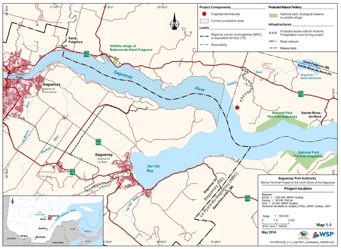
The Saguenay Port Authority (the proponent), a Canadian port authority, is proposing the construction and operation of a multi-user marine terminal in Sainte-Rose-du-Nord, Quebec, to serve the north shore of the Saguenay River (Figure 1). The terminal has a wharf designed to accommodate bulk carriers of up to 100,000 dead weight tonnes Footnote 2, a ship loader, and concentrated ore storage and handling facilities. The first client will be the mining company Arianne Phosphate, which has stated its intention of using this proposed wharf for shipping apatite concentrate that would be produced at the Lac à Paul mine to outside markets. Thus, the Saguenay Port Authority would handle all apatite, from the unloading of non-standard trucks to storage silos to the loading of ships.
1.2 Purpose of the Draft Environmental Assessment Report
This environmental assessment report provides a summary of the information and analyses that the Canadian Environmental Assessment Agency (the Agency) took into account when establishing whether the marine terminal project on the north shore of the Saguenay is likely to cause significant adverse environmental effects, after taking into account the proposed mitigation measures.
When making decisions under the Canadian Environmental Assessment Act, 2012, the Minister of Environment and Climate Change will take into account the final environmental assessment report, which includes comments from Indigenous peoples, the public, the proponent, federal authorities and the Government of Quebec on the draft report. The Minister may request additional information or may require that additional measures be taken in response to comments received on the draft report from the public and Indigenous peoples.
Source: WSP/GCNN, March 2016
1.3 Scope of Environmental Assessment
1.3.1 Environmental assessment requirements
The project is subject to the Canadian Environmental Assessment Act, 2012 because it involves activities that are designated by the Regulations Designating Physical Activities (the Regulations). More specifically, the project includes the construction, operation, decommissioning and abandonment of a new marine terminal designed for accommodating ships of over 25,000 dead weight tonnes , which meets the description and thresholds set out in section 24(c) of the Schedule of the Regulations.
Based on the project description submitted by the proponent, the Agency screened the project to decide whether an environmental assessment was required under the Canadian Environmental Assessment Act, 2012. On April 27, 2015, the Agency invited the public to provide comments on the designated project and its potential environmental effects. Based in part on the comments received, the Agency determined that an environmental assessment was required and this assessment began on June 11, 2015.
The scope of the federal environmental assessment establishes the framework and limits of the analysis conducted by the Agency. The Agency determines the regulatory and legislative requirements of an environmental assessment, the involvement of the federal authorities in the environmental assessment, the factors to be considered, the selection of valued components and the spatial and temporal boundaries.
The Project did not followed the Provincial environmental assessment process; however a collaborative scenario has been established with the ministère du Développement durable, de l'Environnement et de la Lutte contre les changements climatiques for the port expansion projects currently being assessed by the Agency, including that of the Saguenay Port Authority. The approach, developed in the spirit of the Canada-Quebec Agreement on Environmental Assessment, provides for the participation of the Government of Québec in the federal environmental assessment of the project coordinate by the ministère du Développement durable, de l'Environnement et de la Lutte contre les changements climatiques. The ministère du Développement durable, de l'Environnement et de la Lutte contre les changements climatiques convey Quebec's concerns and comments to the Agency so that they can be taken into account at each stage of the federal environmental assessment process. The ministère du Développement durable, de l'Environnement et de la Lutte contre les changements climatiques also participates in environmental assessment committees responsible for the review of port projects.
1.3.2 Elements considered in the assessment
As required by the Canadian Environmental Assessment Act, 2012, the environmental assessment examined the significance of potential adverse environmental effects that are within federal jurisdiction pursuant to subsection 5(1):
- Fish and fish habitat;
- Migratory birds;
- Aquatic species (marine plants);
- Effect of a change that may be caused to the environment on Indigenous peoples, such as on their physical and cultural heritage;
- Effects that cross provincial or international boundaries (for example, greenhouse gasses).
Under subsection 79(2) of the Species at Risk Act, the Agency, as the responsible authority, must identify the project's adverse effects on species listed on the List of Wildlife Species at Risk (Schedule 1 to the Species at Risk Act) and their critical habitats. The Agency notified Fisheries and Oceans Canada and Environment and Climate Change Canada early in the process of the potential for adverse effects on species at risk under their responsability.The environmental assessment therefore took the adverse effects of the project on these species into consideration. If the project proceeds, preventive measures provided for in the applicable recovery strategies and action plans, as well as all additional measures identified in the environmental assessment and deemed necessary by the Minister, must be taken to avoid, lessen, and monitor those effects. Species designated by the Committee on the Status of Endangered Wildlife in Canada are also discussed in the Draft Environmental Assessment Report. Sections 7.4 (marine mammals), 7.5 (birds) and 7.6 (terrestrial mammals) present the Agency's analysis on species at risk potentially affected by the project, based on advice from expert departments.
The following decisions or exercise of powers under other federal legislation may also be required before the project can commence:
- An authorization under section 35 of the Fisheries Act for serious harm to fish;
- An agreement or permit obtained under section 73 of the Species at Risk Act, for engaging in activity affecting a listed wildlife species, any part of its critical habitat or its residences;
- Approvals under sections 6 or 9 of the Navigation Protection Act for works that restrict navigation;
- Exercise of powers granted to the Saguenay Port Authority under sections 28 and 46 of the Canada Marine Act to operate a port and acquire lands necessary for carrying out the project.
Therefore, in accordance with section 5(2) of the Canadian Environmental Assessment Act, 2012, the environmental assessment considered changes to the environment (atmosphere, sound and light, as well as surface and ground water) that could result from these decisions and exercise of powers, as well as any effects on health, socio-economic conditions, physical or cultural heritage, as well as constructions, locations or matters of historical, archaeological, paleontological or architectural interest.
Pursuant to subsection 19(1) of the Canadian Environmental Assessment Act, 2012, the federal environmental assessment took the following factors into account:
- The environmental effects of the project, including the environmental effects of malfunctions or accidents that may occur in connection with the project and any cumulative environmental effects that are likely to result from the project in combination with other physical activities that have been or will be carried out;
- Significance of the environmental effects;
- Comments from the public;
- Mitigation measures that are technically and economically feasible, that would mitigate any significant adverse environmental effects of the project ;
- The requirements of the follow-up program in respect of the project ;
- The purpose of the project;
- Alternative means of carrying out the project that are technically and economically feasible and the environmental effects of any such alternative means;
- Changes to the project that may be caused by the environment ;
- Environmental effects of marine shipping associated with the project that do not fall under the responsibility of and are not monitored by the proponent and that play out in the Saguenay River as far as its mouth in the St. Lawrence River.
For the purpose of the environmental assessment of the Project, the Agency considered that marine navigation within the boundaries of the Project area, namely when vessels are docking or leaving the dock, is an incidental activity to the designated project. The Agency also considered the navigation that would occur in the proponent's (the Saguenay Port Authority) area of jurisdiction.
As proposed, the project site is located outside the area of jurisdiction of the Saguenay Port Authority. This area of jurisdiction is identified in the patent letters of the Saguenay Port Authority, which specify which waters are part of the port. Consequently, the Saguenay Port Authority is currently not responsible for navigation when the vessels are not docked for this project.
However, the Saguenay Port Authority has asked Transport Canada to expand its area of jurisdiction to reach the upper limit of the Saguenay-St. Lawrence Marine Park. This expansion would ensure that its area of jurisdiction would encompass the project site and would then give the Saguenay Port Authority powers to control navigation in this area, even when the vessels are not docking or leaving the dock. It is in this context that the Agency has considered marine shipping occurring in the expanded jurisdiction as part of the designated project. Navigation outside the extended area, i.e. once within the limits of the Saguenay-St. Lawrence Marine Park, however, was not considered as part of the designated project for the assessment of the project's direct effects on the environment.
However, because of the concerns expressed by the public and First Nations, the Agency determined that the marine navigation associated with the project, i.e. occurring outside the area of jurisdiction of the Port Authority in the Saguenay River to its mouth in the St. Lawrence River, was a relevant component to be considered in the environmental assessment under paragraph 19(1)(j) of CEAA 2012. The information collected may be used by the federal government as part of programs or initiatives under federal jurisdiction related to marine traffic and its effects, especially the Oceans Protection Plan available on the Transport Canada website Footnote 3. Under the Canadian Environmental Assessment Act, 2012, the Minister of Environment and Climate Change may require, in the form of conditions, that the proponent implement specific mitigation measures to avoid significant environmental effects under its control.
In addition to public comments, the Agency also considered comments from Indigenous peoples, as well as local and Indigenous traditional knowledge during its analysis.
To determine whether marine shipping is an "incidental activity" that is part of the designated project, the Agency considered the criteria set out in the Guide to Preparing a Description of a Designated Project under the Canadian Environmental Assessment Act, 2012. In light of these criteria, a distinction was made between shipping taking place within the proponent's area of jurisdiction and that occuring outside its area of jurisdiction.
It was determined that marine shipping within the proponent's area of jurisdiction is part of the designated project. Even though the shipping is carried out by third parties and is not for the exclusive benefit of the proponent, shipping within the proponent's area of jurisdiction is part of the designated project because it is complementary to the Project and the proponent has the ability to monitor and direct it. Indeed, the proponent can monitor and direct shipping within its area of jurisdiction by exercising its powers under the Canada Marine Act. For example, the proponent has the ability to authorize vessels to enter its area of jurisdiction.
On the other hand, marine shipping outside the proponent's area of jurisdiction was determined not to be part of the designated project. Although shipping outside the proponent's area of jurisdiction is still an activity that is complementary to the Project, shipping outside the area of jurisdiction is not within the care and control of the proponent and the degree of influence that the proponent could exert on the third parties shipping outside its area of jurisdiction is not sufficient to make it an incidental activity to the Project. In addition, marine shipping outside the proponent's area of jurisdiction is an activity regulated under various laws and would not be solely for the benefit of the proponent. For all these reasons, the marine shipping that would occur outside the proponent's area of jurisdiction is not an incidental physical activity and therefore is not part of the designated project.
1.3.3 Selection of valued components
The valued components assessed by the Agency are presented in Table 1. The Agency focused its assessment of the effects on the valued components within federal jurisdiction, pursuant to section 5 of the Canadian Environmental Assessment Act, 2012 (CEAA 2012), and on species at risk, pursuant to subsection 79(2) of the Species at Risk Act (SARA).
|
Valued Component |
Legislative Requirements |
Rationale |
|---|---|---|
|
Transboundary Effects – Greenhouse Gasses |
5 (1)(b)(ii) CEAA 2012 |
The project would result in emissions of greenhouse gasses that could contribute to increased atmospheric levels worldwide and climate change. Effects on atmospheric greenhouse gas levels are assessed, since they affect changes crossing provincial or international borders. |
|
Wetlands and vegetation, including special-status speciesTable 1 Note 1 |
5 (2)(a) CEAA 2012 79 (2) of the SARA |
The project infrastructure development would lead to deforestation which could affect wetlands, forests of phytosociological interest and special-status plant speciesTable 1 Note 1. |
|
Fish and fish habitat including invertebrates, species at riskTable 1 Note 1 and marine plants |
5 (1)(a)(i) and 5(1)(a)(ii) CEAA 2012 79 (2) of the SARA |
The project would result in habitat loss and changes to surface water quality and currents that are likely to affect marine fish, invertebrates and their habitat, including special-status speciesTable 1 Note 1 and marine plants. |
|
St. Lawrence belugas and other marine mammals, including other special-status speciesTable 1 Note 1 |
5 (1)(a)(i) CEAA 2012 79 (2) of the SARA |
The project could result in the disturbance and mortality of marine mammals, including special-status speciesTable 1 Note 1, such as the St. Lawrence beluga, due to subaquatic noise and the movement of ships. |
|
Birds, including special-status speciesTable 1 Note 1 |
5 (1)(a)(iii) CEAA 2012 – migratory birds 5 (2)(a) CEAA 2012 – non-migratory birds 79 (2) SARA |
The project would lead to a loss of habitat for migratory and non-migratory birds, including special-status speciesTable 1 Note 1, due to the clearing of the site and the construction of marine facilities, and could lead to disturbances due to the change in the levels of noise and light. |
|
Special-status terrestrial mammalsTable 1 Note 1 |
5 (2)(a) CEAA 2012 79 (2) of the SARA |
The project would result in loss of habitat and disturbance to special-status terrestrial mammalsTable 1 Note 1, including bats. |
|
Human health |
5 (1)(c) CEAA 2012 – Indigenous peoples 5 (2)(b)(i) CEAA 2012 – local people |
The project would cause changes to air and surface water quality, as well as to the noise and light environment, which would likely affect human health of the local people and Indigenous peoples. |
|
Current Indigenous use of lands and resources for traditional purposes |
5 (1)(c) CEAA 2012 |
The project would produce changes to the environment, especially to the terrestrial environment, as well as to fish and fish habitat, which could have an impact on Indigenous peoples' current use of lands and resources for traditional purposes. |
|
Physical and cultural heritage |
5 (1)(c) CEAA 2012 – Indigenous peoples and 5(2)(b)(ii) CEAA 2012 – local people population |
The project would transform the landscape and could cause disturbances to historical or archaeological sites with respect to Indigenous peoples and the local people. |
|
Socio-economic conditions |
5 (1)(c) CEAA 2012 – Indigenous peoples 5 (2)(b)(i) CEAA 2012 – local people |
The project would result in loss of terrestrial habitat, transform the landscape and may affect fish and fish habitat, as well as marine mammals in connection with accidents, malfunctions and the increase of traffic. This would have an effect on the socio-economic conditions of Indigenous peoples and the local people, especially in terms of access to tourism activities and recreational and commercial fishing as well as to fishing and trapping. |
Table Notes
- Table 1 Note 1
-
Special-status species include species on lists under federal and provincial legislation. Effects to species at risk are assessed under section 79 of the Species at Risk Act and take into account species for which the Committee on the Status of Endangered Wildlife in Canada (COSEWIC) recommends a change in status or their addition to the list of species at risk.
1.3.4 Methodology and approach
Spatial Boundaries
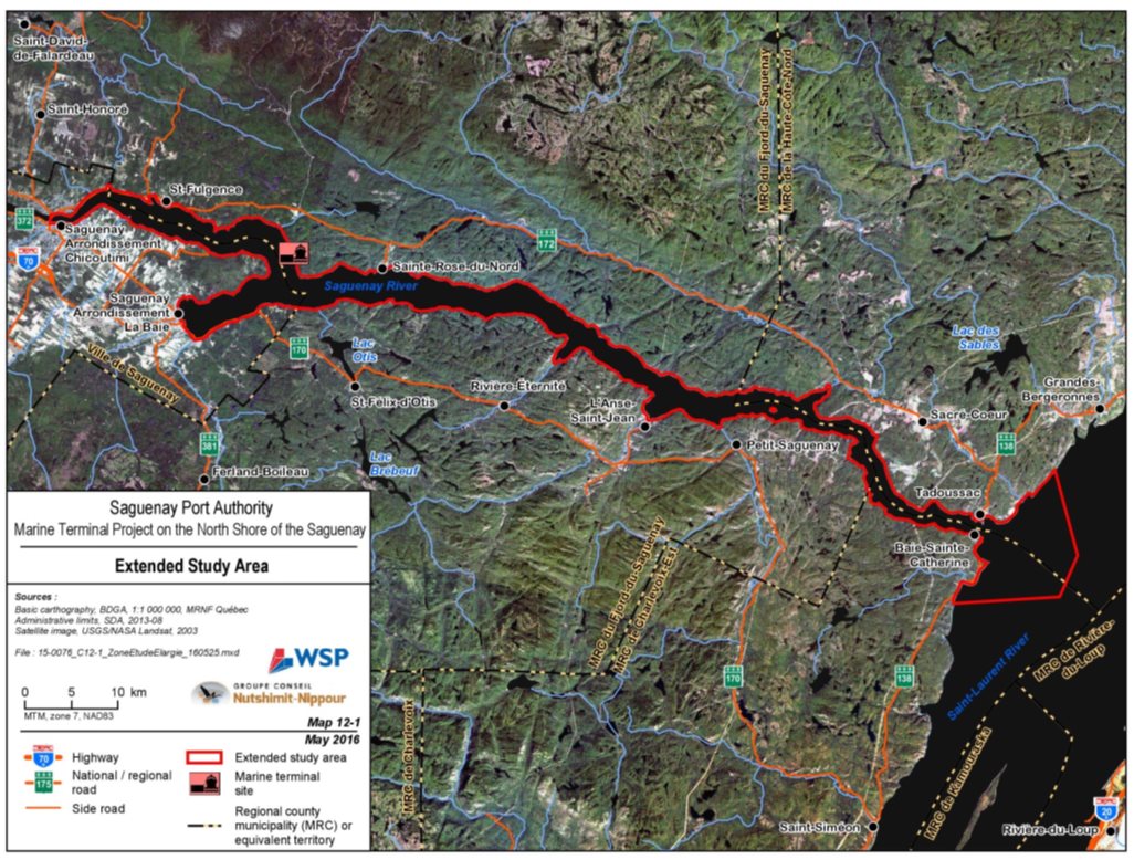
Spatial boundaries identify the geographic areas within which the potential effects from the project may occur. The proponent established a limited study area of 87.8 hectares, which corresponds to the project's infrastructure footprint in terrestrial and marine environments and the immediate vicinity (Figure 2). The proponent then established the study areas adapted to each valued component according to the different geographical ranges to adequately describe the existing conditions of the receiving environment before the project, and to assess the potential effects of the project on each valued component. For example, when establishing the spatial boundaries of the landscape study area, all the possible points of view on the port facilities projected within a radius of approximately 25 kilometres were included (Figure 2).
The proponent defined an extended study area to assess broader issues such as the assessment of cumulative effects on beluga whales and documentation of the effects of traffic beyond the proponent's control. The extended study area takes into consideration the Saguenay River and its shores, the Dubuc Bridge in the City of Saguenay upstream from the project site, all the way to its mouth into the St. Lawrence River (Figure 3).
The definitions of the spatial boundaries of the study areas given by the proponent were used in Chapter 6 of this report, unless otherwise specified in the Agency's analysis and conclusions. For example, for the assessment of the environmental effects of the project on bats, the Agency asked the proponent to redefine the local study area so that it corresponded to the project's area of influence on bats so as to adequately assess the effects of the project on these species.
Temporal Boundaries
Temporal boundaries are set to take account of all project activities likely to cause adverse environmental effects. With respect to this environmental assessment, the temporal boundaries considered include the project's lifecycle, namely the construction and operation of the terminal, as well as the construction, operation and decommissioning of the specific infrastructure that the terminal's clients need. Project activities related to each of these phases are described in Table 2. The Agency used the temporal boundaries defined by the proponent in the impact statement, but added clarifications with respect to potential clients of the terminal for the adequate assessment of the potential environmental effects of the project:
Construction: The construction of the multi-user infrastructure (access road to the terminal, ship loader, wharf and storage area adjacent to the wharf) as well as infrastructure required for the terminal's first client (ore unloading and storage site, conveyor) will begin and continue for a period of two to three years starting from the date of the decision made under the Canadian Environmental Assessment Act, 2012.
Operation: The terminal will begin to operate after the construction of the multi-user infrastructure and facilities related to the terminal's first client and will continue beyond 40 years. The terminal's operation phase therefore includes the construction of any new infrastructure that may be required to allow other clients to use the terminal's services. The facilities required for the storage and transshipment of the ore or materials of the terminal's clients will be in operation during the service life of the related projects.
In the case of the terminal's first client, the facilities for unloading of trucks and storing apatite ore will be in operation over a period estimated at 26 years.
Decommissioning and abandonment: No abandonment date has been scheduled for the wharf or the multi-user infrastructure, namely ship loading facilities (ship loader) and their related infrastructure (access road, administration building, well for drinking water, electrical building). This multi-user infrastructure is proposed for long-term use and would be dismantled only if the proponent decides to cease its port operations.
Dismantling of the specific facilities required by terminal clients is scheduled for the end of the service life of their related projects. In the case of facilities related to apatite storage and transshipment, approximately 12 months would be needed to dismantle them.

Source: WSP/GCNN, March 2016
Source: WSP/GCNN, March 2016
Assessment of effects
The Agency, in collaboration with the federal committee (see section 4.3), defined and assessed the project's adverse environmental effects based on the proponent's Environmental Impact Statement, additional information requested, comments received from the public and Indigenous peoples, and the views of the federal government and the Government of Quebec. The Agency examined the potential environmental effects on the valued components identified in Table 1, both the project's direct effects and the effects that may result from anticipated changes to the environment (atmospheric, sound and light, as well as surface and ground water), and determined the residual effects after taking into account the implementation of mitigation measures and monitoring programs. The Agency then determined the significance of residual effects for each valued component. Should the Agency has identify significant adverse residual effects, the likelihood of such effects occurring has also been assessed in accordance with the Agency's Operational Policy Statement: Determining Whether a Project is Likely to Cause Significant Adverse Environmental Effects under the CEAA, 2012. This methodology is different from the one used by the proponent, which integrates the likelihood of occurrence as a criterion for determining the significance of all effects assessed. However, The Agency retained the proponent's methodology for assessing the magnitude of effects (indicated as the intensity), which incorporates the environmental value of the components and the degree of disturbance that is established by considering the frequency of effect expected.
The Agency used the following criteria to characterize the significance of residual effects after mitigation measures, with each criterion being adapted to the valued component assessed:
- Magnitude: the amount of change or severity of the effect relative to baseline conditions considering the environmental value of the valued components and the frequency of an effect.
- Extent: the geographic area over which an effect will occur.
- Duration: the period of time over which an effect will occur.
- Reversibility: the reversible or irreversible nature of an effect.
The Agency assigned three levels for each criterion. For example, duration, as a criterion, was rated either as short, medium or long-term. The Agency also took into account current federal and provincial regulatory standards, criteria and guidelines to determine the significance of the residual effects. Appendix A defines the Agency's assessment criteria for each valued component. In certain cases, the Agency accepted the proponent's criteria, thresholds and characterization of residual effects as being adequate for the purposes of assessing environmental effects under the Canadian Environmental Assessment Act, 2012. However, the Agency defined its own criteria for assessing effects and conducted the assessment differently than the proponent for some valued components. To make it easier for the public to understand, the Agency has also defined, in Annex A, a significance threshold that describes what the Agency considers to be a significant effect for each valued component. The differences in assessment are noted in the sections on changes to the environment and relevant valued components in Chapters 6 and 7. The Agency then used a grid that combines the levels assigned to each of the criteria (magnitude, extent, duration, reversibility) to determine the significance of each of the residual effects for each valued component (see Appendix B). Appendix C summarizes the Agency's assessment of residual effects following mitigation measures.
2 Project Overview
2.1 Project Location
The Saguenay Port Authority (the proponent) proposes the establishment of a multi-user marine terminal on the north shore of the Saguenay River. The facilities would be located within the limits of the municipality of Sainte-Rose-du-Nord, in the Fjord-du-Saguenay Regional County Municipality (MRC), as shown in Figure 1 (Chapter 1).
The centre of the site where the facilities are slated to be built has the following geographic coordinates: 48° 24' 04" North and 70° 43' 23" West. The land in question is located between the towns of Sainte-Rose-du-Nord and Saint-Fulgence. The land at the project site is currently zoned as recreational according to the Fjord-du-Saguenay MRC Development Plan. The regional zoning must be legally changed and this change must be endorsed by the MRC so that the projected industrial facilities may be developed.
A road built south of Highway 172 would provide access to the site. This private road, access to which would be controlled by a gatehouse, would be owned by the mining company Arianne Phosphate up to the property limit of the terminal site. Arianne Phosphate would grant access rights to the Saguenay Port Authority and its users for the portion of the road belonging to it, i.e. between Highway 172 and the terminal site.
In terms of maritime aspects, the project site is currently located outside the Saguenay Port Authority's area of jurisdiction established under the Canada Marine Act. The proponent has submitted a request to the Canadian Minister of Transport to change its current area of jurisdiction to include the baie des Ha! Ha!, as well as the area downstream from its current boundaries to those of the Saguenay—St. Lawrence Marine Park. This new area of jurisdiction would include the project site, currently in a non-regulated area, and give the proponent the legitimacy and the means to act as the local marine coordinator since it would have the powers to manage marine shipping throughout the Saguenay River sector between the marine park and its current facilities at Grande-Anse. The Agency will therefore take into account the increased powers of marine shipping management that could be granted to the proponent in its recommendations to the Minister.
2.2 Project Components
This proposed project is a multi-user terminal. Although only one user is known at the moment by the Saguenay Port Authority, these components and activities described below, whose environmental effects are analyzed, are those anticipated for maximum operation by more than one user.
For the purposes of the environmental assessment, the proponent considered a plausible, albeit extreme, scenario of the potential maximum use of the terminal on the Saguenay's North Shore that could occur, should all anticipated clients were to come forward. This scenario includes two high-volume bulk (long-term) clients, a low-volume bulk (long-term or short-term) client, and cargo (sporadic) clients.
Although the terminal could accommodate ships up to 100,000 dead weight tonnes, the scenario described by the proponent considers that clients would use ships of 50,000 dead weight tonnes. The wharf would only be able to accommodate one ship at a time.
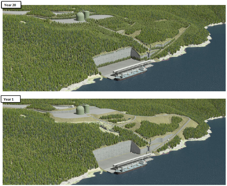
The Arianne Phosphate mining company would be the first confirmed high-volume bulk client that plans to ship three million tonnes per year of apatite ore by truck via a non-standard road to the terminal. The multi-user components of the terminal project, as well as those related to the activities of Arianne Phosphate, are illustrated in Figures 4 and 5 and include a wharf, a storage area adjacent to the wharf, a non-standard truck unloading area and storage silos built at the top of the cliff, conveyors between the silos and the ship loader built on the wharf, as well as an access road and a paved non-standard road and supporting facilities.
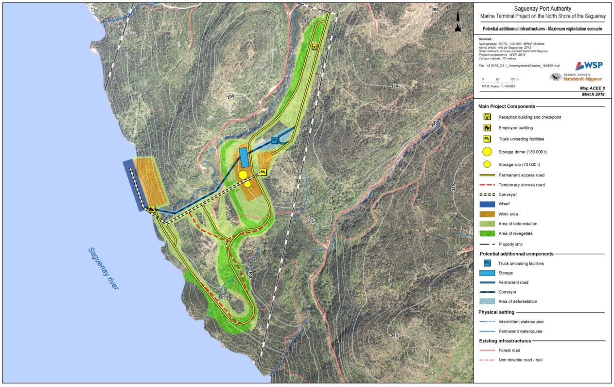
Figure 6 illustrates the plausible scenario of additional infrastructure construction being required by unconfirmed potential clients (high-volume bulk mining company, low-volume bulk mining company and general cargo clients).

Source: WSP/GCNN, May 2016
Source: WSP/GCNN, May 2016
Source: WSP/GCNN, March 2018
The second potential high-volume client could be a mining company with equivalent annual tonnages, the same types of transshipment, conveyor loading, and ship. The ore would be conveyed to the terminal by 120-tonne tractor trailers on the non-standard road. It would be necessary to build the ore storage infrastructure (silo or hangar) as well as a new conveyor to transport this ore to the wharf conveyor. The wharf conveyor and the ship loader would serve the two mining clients in turn.
The potential low-volume bulk mining client would use the storage area adjacent to the wharf to store the ore. The ore would be transported by truck on the paved access road (Figure 4).
Potential cargo clients could be in forestry or industry and would use the storage area adjacent to the wharf to store off-standard cargo (very heavy loads, prefabricated parts or large structures) or products from manufacturing firms for export via ships. As with the low-volume bulk mining client, cargo would be trucked on the paved access road between the wharf and the unpaved, non-standard road giving access to Highway 172.
Considering the proponent's proposed operating scenario, the project components subject to this environmental assessment are as follows (Figures 4 and 6):
Wharf: The wharf is a combined wall gravity wharf (Figure 7) and would consist of a main facade wall (110 piles and sheet piling connected together) secured in place at the top by a series of steel tie rods and anchor blocks. The back of the wall would consist of caissons that would be backfilled and covered with paving. Rip rap would be installed on the bed of the Saguenay River at the foot of the wharf to stabilize the structure. The wharf would be about 280 metres long and be between 55 and 85 metres wide depending on the profile of the shore, for an average of 71 metres. The wharf is designed to support a rail-mounted ship loader, conveyor and electrical building for the operation of equipment.
Storage area adjacent to the wharf: The storage area adjacent to the wharf, measuring approximately 27,000 square metres located behind the wharf, would allow for the transshipment of ore (other than apatite) and miscellaneous general cargo, the manoeuvring of vehicles and the development of sedimentation basins for runoff from the access road, the wharf and the area itself. Blasting would be necessary so that the basin could be developed; this blasting would expose a rock face about 65 metres high and 280 metres wide.
Unloading areas for trucks: For the needs of the first client, the truck unloading area would measure approximately 8,060 square metres at the top of the cliff. Two hydraulic hoists would be used to lift the trucks and unload the apatite concentrate contained in closed trailers to a conveyor that would transfer the apatite to a buffer ditch with a capacity of 180 tonnes.
The tilting unloading platform would allow the apatite concentrate to fall onto a forced air conveyor at a rate of 1,200 tonnes per hour (tph). The 82-metre-long conveyor for conveying material to a storage area (silo and dome) would be inserted into a closed tubular gallery 1.8 metres in diameter. A dust collector with filters would control fugitive dust emissions from unloading trucks and would send them back to the pit, where they would be mixed with the main flow of apatite.
For the needs of a future mining client of the same calibre, a second truck unloading area would be developed to the northeast of the apatite truck unloading area, in the space available between the access road to the terminal and the non-standard road. This unloading area, which would include ore unloading and conveyance infrastructure, would occupy a ground area similar to that developed for apatite.
Ore storage area: An ore storage area of 57,000 square metres would be developed at the top of the cliff. For the needs of the first client, a silo with a total capacity of 70,000 tonnes and a dome with a capacity of 130,000 tonnes would be built side-by-side. The silo and dome would be entirely automated for efficient management of storage.
For the needs of a future mining client of the same calibre, a silo or a hangar would be built to store ore north of the storage infrastructure planned for apatite inside the 57,000 square metre storage area.
Conveyors: For the needs of the first client, various conveyor systems with a total length of approximately 600 metres would convey apatite concentrate from the trucks to the silo or storage dome at the top of the cliff, then from these storage areas to a transfer silo of 700 tonnes built on the wharf. For the needs of a future mining client of the same calibre, another conveyor system would need to be built between the ore storage area and a new transfer silo that would need to be built on the wharf.
A wharf conveyor, which can be used by more than one client (one client at a time), would then transport the ore from the transfer silo (apatite or other ore) to the ship loader at a speed of 2,700 tph.
Ship loader: A ship loader with a telescopic loading spout for loading the ship would be built on the wharf. This ship loader may be used by more than one client (one client at a time).
Roads: From the northern property limit of the terminal site, the Saguenay Port Authority will build a paved access road approximately 800 metres long to provide access to non-standard trucks to the unloading area (Area 1). This access road would be built in continuation of the 6.8 km gravel access road that would be built by Arianne Phosphate to access the terminal site from Highway 172. A second paved access road of approximately 2.75 km would be built by the Saguenay Port Authority to access the wharf (Area 2). The access road to Area 2 would be used primarily by light trucks for maintenance, snow removal or, in case of emergency, to aid a bulk carrier's crew, as well as for the transport of ore (low-volume bulk unloaded directly on the wharf) or general cargo from future forestry or industrial clients that would use the area adjacent to the wharf to store their ore or cargo.
Supporting facilities: A number other facilities are planned, including an administrative building and a gatehouse controlling access to the site, an administrative building built behind the wharf to accommodate 12 employees, sedimentation basins for surface water, 3 wells for drinking water and septic systems, a main electrical room near the storage silos and a second near the wharf.

Source: WSP/GCNN, March 2018
2.3 Project Activities and Timetable
The activities required to carry out the multi-user terminal project are described in Table 2 by phase of the project's lifecycle, ranging from construction to dismantlement of the terminal clients' infrastructure. No abandonment date has been scheduled for the wharf or the multi-user infrastructure, namely ship loading facilities (ship loader) and their supporting infrastructure (access road, administration buildings, well for drinking water, electrical buildings). This multi-user infrastructure is proposed for long-term use and would be dismantled only if the proponent decides to cease its port operations. Dismantling of the specific facilities required by terminal clients, however, is scheduled for the end of the service life of their related projects. The activities of the terminal's first client, Arianne Phosphate, are estimated to be over 26 years.
|
Development stage |
Physical activities |
Description |
|---|---|---|
|
Construction of infrastructure for the first client (apatite mining company): Duration of approximately 2 years |
Site preparation |
|
|
Land construction |
|
|
|
Marine construction |
|
|
|
Transport, movement and operation of machinery |
|
|
|
Waste recycling and disposal |
|
|
|
Restoration |
|
|
|
Construction of infrastructure specific to other potential clients: Duration of less than 2 years |
Land construction |
|
|
Operation: Duration of a minimum of 26 years (first client) |
Marine terminal use |
Operation by only one user
Maximum multi-user operation (plausible scenario)
|
|
Traffic |
Operation by only one user
Maximum use (plausible scenario)
|
|
|
Transport, movement and operation of machinery |
Operation by only one user
Maximum use (plausible scenario)
|
|
|
Waste recycling and disposal |
For all operating scenarios (only one client and multi-user)
|
|
|
Decommissioning of facilities related to specific activities of terminal clients: Duration of approximately 1 year for high-volume bulk mining clients |
Dismantling of facilities |
|
|
Waste disposal |
|
3 Purpose of Project and Alternative Means under Consideration
The information gathered on the project's context, purpose and alternative means is used to inform the Minister of Environment and Climate Change to support her decision-making when she considers the Agency's recommendations regarding the significance of the project's environmental effects.
3.1 Context and Purpose of Project
The Saguenay Port Authority wishes to expand its activities and service to the north shore of the Saguenay River by developing a new multi-user marine terminal. The proponent states that this project would allow the development of the natural resources found in a vast northern territory that is currently not serviced by the marine mode of transport. The north of the region is composed of a number of non-standard roads, originally used by the forestry sector, but these roads do not lead to port facilities or railways. Exports from this territory must therefore be transported on (standard) public roads to reach Grande-Anse, located on the south shore and the only deep-water port in the region.
The impetus for this project is the need expressed by mining company Arianne Phosphate to export apatite concentrate from a terminal that would be located on the north shore of the Saguenay River. At present, Arianne Phosphate is the only client identified for the proposed terminal. The proponent has specified that it would proceed with the construction of the north shore marine terminal once it has the assurance that a client will use the terminal. The proposed project, however, aims to provide turnkey infrastructure to meet the needs of a number of potential smaller-scale clients or to accommodate another client of similar calibre while maintaining a continuous flow of operations (see Chapter 2).
The proponent states that its project is in keeping with recent government efforts to diversify the economy, especially with the creation of the "Plan Nord"Footnote 4 development and enhancement program and the implementation of the "Maritime Strategy"Footnote 5. The project was identified as a regional priority in the transport sector by a working group set up following the Sommet économique régional du Saguenay – Lac-Saint-Jean in June, 2017 Footnote 6. The proponent adds that the territory that the terminal could service has recognized and diversified mining potential, especially for industrial minerals (apatite, granite, peat, calcite, wollastonite) and high-technology metals (niobium, tantalum, vanadium). Given Canada's current lumber exports, the proponent believes that a new north shore terminal would also foster the diversification of markets for the region's forestry sector, which includes a sawmill and wood processing plants located less than 80 kilometres away.
Against this backdrop, the proponent points out that through this multi-user project, basic infrastructure would be built for use by a number of clients at the outset, primarily the wharf, the storage area behind the wharf, the access road and common services. These elements to be used by different types of users are related to construction work that would be difficult to complete when the terminal is in full operation. For example, expanding the storage area behind the wharf for a second client would require blasting that could damage infrastructure in place. Thus, the wharf area was designed to encompass 27 hectares, rather than the 12 hectares that would be sufficient for Arianne Phosphate. Choosing this multi-user concept means that the rock wall behind the wharf would be increased from 25 metres to 40 to 65 metres.
The proponent states that expanding or modifying the multi-user infrastructure while the terminal is in full operation would entail significant costs, unacceptable operating constraints, and additional environmental effects because of the short production cycles of the known client (mining company Arianne Phosphate). Supporting facilities required for other high-volume users, such as a second ship loading system intended for another ore or storage structures (silo, hangar), would have fewer constraints and could be built while terminal operations are ongoing.
In connection with the concerns received regarding the choice of a new site on the north shore as opposed to using the existing infrastructure at Grande-Anse for exporting apatite or other potential resource-based clients north of the Saguenay River, the proponent provided additional information, including a number of analyses of transport alternatives carried out by Arianne Phosphate. The proponent specified that the scenarios for shipping large volumes of ore by truck and then by train from the apatite mine to the Grande-Anse terminal involve more transshipments (truck-train-boat) and a greater distance travelled between the mine and the terminal. This increases transport costs and makes these scenarios economically unviable. The proponent states that transporting large volumes of ore by train to the Grande-Anse terminal would involve significant logistical limitations related to the co-use of the Roberval-Saguenay railway line by other users. The proponent also argued that these scenarios would have a greater impact on residential areas, which would increase in number along the corridors assessed.
In response to the concerns raised about the project's effects on ongoing efforts to have the Saguenay Fjord recognized as a UNESCO (United Nations Educational, Scientific and Cultural Organization) World Heritage site, the proponent considers that the presence of the terminal should not result in any environmental effects on the portions of the Fjord that could meet UNESCO criteria. According to its analysis, the project would be part of a portion of the Saguenay River already featuring port facilities at Grande-Anse on the opposite shore. This means that the portion of the Fjord targeted by the project currently does not comply with UNESCO World Heritage Convention guidelines for selecting sites.
3.1.1 Comments received
Government authorities
The ministère du Développement durable, de l'Environnement et de la Lutte contre les changements climatiques indicates that according to the state of knowledge of mining development, there is currently no potential for development or exploitation of another mining deposit in the area of influence of the project.
Thus, the ministère du Développement durable, de l'Environnement et de la Lutte contre les changements climatiques is of the opinion that the construction of a multi-user marine terminal is not desirable or justified, and favors a single-use terminal dedicated to the Arianne Phosphate mine.
The ministère du Développement durable, de l'Environnement et de la Lutte contre les changements climatiques is of the opinion that the multi-user project would entail significant additional encroachment on the seabed, shore or land and that its implementation would significantly and irreversibly alter the landscape of the fjord.
The ministère du Développement durable, de l'Environnement et de la Lutte contre les changements climatique expressed concerns that the project and the terminal's future multi-user use could alter the physical heritage of the site. Furthermore, given the uncertainly of clients other than Arianne Phosphate coming to use the terminal, the ministère du Développement durable, de l'Environnement et de la Lutte contre les changements climatiques stated that it had grave concerns about the environmental effects of a multi-user wharf compared with the effects to be expected were the terminal to be developed for one client only. In addition, a wharf dedicated to a single client would reduce the effects associated with blasting, in particular by reducing the volumes of rock to be extracted, the height of the rear wharf and the duration of the work
First Nations
The Innu Essipit, Pekuakamiulnuatsh (Mashteuiatsh), and Innu of Pessamit First Nations also expressed concerns about the possibility of the terminal project, because of its effects on the landscape, being carried out without the assurance of a first client. The Essipiunnuat Footnote 7 said that there is a great deal of historical, toponymic and other literature demonstrating the importance of the Saguenay Fjord. The Essipit Innu First Nation also emphasized its involvement with other partners to have the Saguenay fjord designated as an UNESCO World Heritage site. The Saguenay Fjord also represents a site of national interest for the Huron-Wendat Nation.
Public
The public expressed concerns similar to those raised by the ministère du Développement durable, de l'Environnement et de la Lutte contre les changements climatiques and the Innu Essipit, Pekuakamiulnuatsh (Mashteuiatsh), and Innu of Pessamit First Nations and also called into question the choice of a site on the north shore where a railway cannot be constructed due to the topography, which would force potential clients to ship by truck with the concomitant air and noise pollution. The proponent provided an assessment of the project's trucking-related effects considering the maximum possible use of the terminal by more than one client, and the number of trucks required for each of these clients. These effects have been detailed in Sections 6 and 7 of this report.
3.1.2 Agency Analysis and Conclusion
The Agency reviewed the information the proponent submitted on the context and purpose of the project and considers that the proponent has satisfactorily justified the purpose for its multi-user wharf project for the needs of an environmental assessment. The Agency is satisfied with the proponent's responses to the concerns raised, as well as explanations provided for the environmental effects of the project's multi-user design, the rationale for choosing a site on the north shore and the fact that a first client will have to be confirmed before starting construction work on the terminal.
3.2 Alternative Means of Carrying Out the Project
In the Environmental Impact Statement, the proponent identified alternative means of carrying out the project that are economically and technically feasible. The proponent described general environmental effects associated with each alternative and the rationale for the choice of the preferred alternative. Alternative means were considered for the following project components: location of the marine terminal and type of wharf.
The proponent explained why it did not provide an analysis of alternatives for some of the potential activities identified in the guidelines resumed hereafter. The approach channel: no approach channel is necessary since the water at the site is very deep. Anchorage areas: in this sector of the Saguenay River, the pilots themselves determine where the anchorage areas are when required given that the water is very deep and there is little traffic. Apatite concentrate transport systems and ship loading: the proponent has opted for fully closed efficient systems with a minimum number of mechanical parts (less dust and noise). Finally, no dredging or maintenance are required for the proposed project.
Marine terminal location
Three alternatives were identified as possible locations for the marine terminal on the north shore of the Saguenay River following a detailed analysis of the transport options for apatite concentrate between the Lac à Paul mine and the north shore of the Saguenay River (Figure 8). These three sites are located in the same section of the Saguenay River between the Parc Aventures Cap Jaseux and the Pourvoirie du Cap au Leste. The "upstream" site is located near the Jalbert Islands west of the Pelletier River, while the "centre" site is located near the Anse à Pelletier, very close to the limits of the municipalities of Saint-Fulgence and Sainte-Rose-du-Nord. The "downstream" site is located not far from the "centre" site, but in the municipality of Sainte-Rose-du-Nord. These three sites were assessed for the minimization of the following:
- The length of the truck route between the mine and the terminal;
- Environmental constraints (wetlands, protected areas, forest stands of interest, nesting sites of birds at risk, number of watercourse crossings, disturbance of landscape areas);
- Technical and economic constraints (areas at risk of ground motion);
- Disturbance of inhabited areas (distance from residences, preferring the road corridor between Highway 172 and the terminal site in sectors where there is already disturbance);
- Construction costs.
The next sections provide a summary of the comparative analysis of the three alternatives:
The downstream alternative in Sainte-Rose-du-Nord was selected by the proponent. The main element that led to the choice of this site was the fact that it is far from the dwellings located in the Anse à Pelletier sector more than three kilometres away. The proponent stated that the site selected has fewer biological resources than those in the coastal area according to inventories. The site also has a bottom configuration with a slope that is steeper to the right of the wharf and is deemed more conducive to ship manoeuvres, and which would limit the footprint of wharf infrastructure on the seabed.
The road and operation area would be less expensive to build at the upstream alternative located in the municipality of Saint-Fulgence. However, this alternative site contains a large area of aquatic plants in the coastal area and is located near the highest number of dwellings at Anse à Pelletier about 900 metres away. The site is also close to the Jalbert Islands, a vacation spot and prime area for kayaking.
The centre alternative, located in Saint-Fulgence between the upstream and downstream alternatives, has the highest construction costs due to the need to build a tunnel for non-standard trucks (Figure 8). Although the environmental constraints are similar to the chosen alternative, the presence of a building on the adjacent property and a residence 435 metres away is a major constraint justifying the proponent's rejection of the centre alternative.
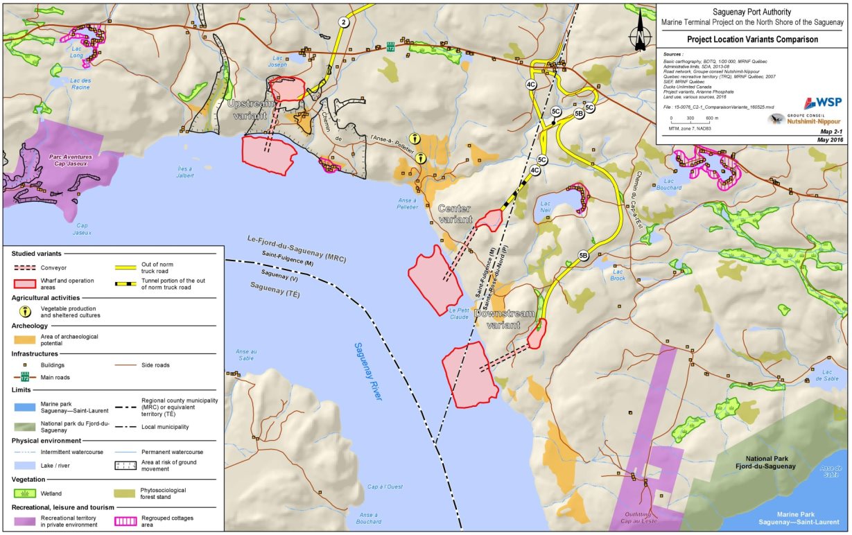
Source: WSP/GCNN, May 2016
Type of wharf
Ten potential wharf concept alternatives were assessed by the proponent: wharf on piles, two floating wharves and four gravity wharves. The use of a barge-mounted loader was also assessed. The various concepts were assessed based on their advantages for multi-user use, constructability and operability, construction costs, maintenance costs, and minimized effects on the environment. According to the proponent, only the wharves on piles and gravity wharves fulfilled the project's multi-user objectives. Some of the alternatives were therefore not retained, despite fewer effects on the environment in terms of encroachment on the seabed.
Wharf on piles: A wharf erected on a series of piles spread out under the entire surface of the wharf and fixed in the bedrock at the bottom of the watercourse.
Floating wharf: A wharf whose surface floats and is anchored to the shoreline by walkways for pedestrians or small service vehicles. It may be necessary to anchor some piles to the bottom of the watercourse for its installation.
Gravity wharf: A wharf that rests on solid structures, such as concrete caissons or metal structures (sheet piling), anchored to the bottom of the watercourse and filled with crushed rock. The surface of the wharf is built over this embankment.
Barge-mounted loader: This is not a wharf per se. A series of mooring dolphins (metal or reinforced concrete piles) are placed in the water parallel to and far enough from the shore so that ships can dock there. A barge is placed between the shore and the ship and serves as a bridge to install a conveyor so that ships may be loaded.
According to the proponent, gravity wharves would be the best technical and economic option because they offer more opportunities for multi-user use; their greater bearing capacity means that they can support a greater bulk or cargo weight. Gravity wharves would also be less expensive to maintain. From among the various gravity wharf options, the proponent has retained a combined wall gravity wharf concept because it does not require blasting of the seabed and hence has fewer effects on the environment. The combined wall gravity wharf consists of a sheet pile wall (interlocked steel beams) and piles anchored to the bedrock at the bottom of the watercourse. The space between the wall and the shore is then filled with rock excavation materials to form the wharf surface. Encroachment on the seabed would be about 18,200 square metres.
The proponent will conduct geotechnical studies at the final plans and specifications stage in order to demonstrate the feasibility of this option. In the event that a gravity wharf cannot be built, the proponent proposes to build a wharf on expanded piles. Encroachment on the seabed would be half of what it would be with a gravity wharf, about 9,000 square metres, despite the higher number of piles, and would not require backfilling. Expanded piles would be more costly in terms of construction and maintenance, however, and would not have the bearing capacity required for heavy loads, which could restrict its use by multiple users.
With respect to the assessment of other types of wharf that would have ensured the integrity of the shore and coast and would not have required the excavation of the cliff, the proponent responded that these types of wharf would not apply to their project of meeting the needs of a wide variety of clients and products that are still unknown. The proponent said that the design retained is essential in order to take advantage of the full capacity of the infrastructure and offer services that are adequate for multi-user handling, including sporadic or short-term transits.
3.2.1 Comments received
Government authorities
Fisheries and Oceans Canada has asked for more information regarding the potential effects of a wharf on expanded piles and especially subaquatic noise. The proponent responded that the wharf on expanded piles option has more piles to drive into the seabed and, as a result, the work generating subaquatic noise work would take longer than that required for a gravity wharf. However, there would be less (9,000 square meters) encroachment on the seabed than for the combined wall gravity wharf (18,500 square metres).
The ministère du Développement durable, de l'Environnement et de la Lutte contre les changements climatiques requested that the proponent justify why it did not assess the possibility of building other types of wharf that would have made it possible to ensure the integrity of the shore and coast and would not have required cliff excavation. The proponent replied that excavation of the cliff would be necessary to develop an area behind the wharf for storage of equipment to serve several clients.
The ministère du Développement durable, de l'Environnement et de la Lutte contre les changements climatiques is not in favor of the chosen wharf variant considering its encroachment of 18,600 square meters on the marine environment, as it considers that the justification for a multi-user marine terminal has not been demonstrated. The ministère du Développement durable, de l'Environnement et de la Lutte contre les changements climatiques is of the opinion that the variant of pile dock with prefabricated slab evaluated by the proponent (variant 3 in the impact study), presents a better balance between the "environment" and "economic / technical" components. The proponent responded that the wharf version with prefabricated slab has not been selected as it would not allow the project as proposed.
First Nations
The Innu Essipit, Pekuakamiulnuatsh (Mashteuiatsh), and Innu of Pessamit First Nations as well as the Huron-Wendat Nation consulted did not express specific concerns about the alternative means submitted for carrying out the project.
Public
The public questioned the choice of the project site in a currently undeveloped area of the Saguenay Fjord. The proponent pointed out that the primary purpose of building the terminal was to meet the need of the mining company Arianne Phosphate which, following an analysis, identified the north shore of the Saguenay River as the most effective area for transporting minerals to markets. It added that this location would have the benefit of serving other potential resource-based clients north of the Saguenay River.
Questions were raised as to whether the proponent had considered the possibility of building minimal infrastructure for the sole purpose of loading apatite for the only known client. The proponent responded that the proposed project was a multi-user wharf and not a wharf dedicated solely to the Arianne Phosphate mining company. Concerns were also raised that the proponent favoured technical and economic criteria in choosing the type of wharf to the detriment of environmental criteria since, among the alternatives presented, it did not choose those with the least environmental effect. The proponent responded that certain alternatives initially presented were not retained, despite their lesser environmental effect in terms of encroachment on the seabed, since they did not allow for multi-user use.
3.2.2 Agency Analysis and Conclusion
The Agency reviewed the proponent's assessment of the alternative means and its responses to concerns raised. As for the location of the terminal and the type of wharf, the proponent identified the technically and economically feasible alternative means and identified the environmental effects. The proponent chose the preferred alternative of a combined wall gravity wharf to be submitted for a full assessment. The Agency notes that the proponent will conduct geotechnical studies at the final plans and specifications stage in order to demonstrate the feasibility of the combined wall gravity wharf option. In the case where a gravity wharf cannot be built, the proponent proposes to build a wharf on expanded piles. Although the ministère du Développement durable, de l'Environnement et de la Lutte contre les changements climatiques recommended the option of constructing a pile dock with prefabricated slabs to reduce the footprint on the seabed, the Agency, based on the advice of Fisheries and Oceans Canada, concluded that the effects of the selected alternative means, a gravity dock, on the marine environment are not significant. Thus, considering the proponent's explanation that only gravity wharf types could have a bearing capacity to fully meet the objectives of the project, the Agency did not require the proponent to select a type of pile dock.
The proponent adequately justified that no alternative analysis was conducted for certain potential activities set out in the guidelines, particularly for dredging, since no dredging is required for the proposed project.
The Agency is satisfied with the responses the proponent provided to concerns raised. The Agency is satisfied that the proponent has sufficiently assessed alternative means of carrying out the project for the purposes of assessing the environmental effects of the project under the Canadian Environmental Assessment Act, 2012.
4 Consultation Activities and Advice Received
Public and Indigenous consultations strengthen the quality and credibility of environmental assessments. Among other things, local and traditional knowledge about a project's physical location can help to identify and address potential environmental effects at an early stage of an environmental assessment. For the Marine Terminal Project on the North Shore of the Saguenay, the Agency, together with the federal environmental assessment committee, conducted a number of consultation activities with the public and the Innu Essipit, Pekuakamiulnuatsh (Mashteuiatsh), and Innu of Pessamit First Nations. The proponent also conductedconsultations with the public and the Innu Essipit, Pekuakamiulnuatsh (Mashteuiatsh), and Innu of Pessamit First Nations.
4.1 Indigenous consultation
4.1.1 Indigenous consultation led by the Agency
The federal government has a duty to consult and, where appropriate, to accommodate Indigenous peoples when it contemplates decisions that might adversely impact established or potential Aboriginal and treaty rights. Indigenous consultation is also undertaken more broadly as an important part of good governance, valuable policy development and sound decision making. Moreover, the Canadian Environmental Assessment Act (2012) requires that federal environmental assessments take into consideration changes to the environment that may affect Indigenous peoples, in areas such as:
- Health and socio-economic conditions;
- Physical and cultural heritage;
- Current use of lands and resources for traditional purposes;
- Structures, sites or things that are of historical, archaeological, paleontological or architectural significance.
For the purposes of the environmental assessment, the Agency served as Crown consultation coordinator to facilitate a whole-of-government approach to consultation. The First Nations that were invited to participate in consultations included those whose potential or established Aboriginal or treaty rights could potentially be adversely affected by the project. These are:
- Innu Essipit First Nation;
- Pekuakamiulnuatsh (Mashteuiatsh) First Nation;
- Innu of Pessamit First Nation;
- Huron-Wendat Nation.
The proposed project could have direct environmental effects on the Innu First Nation of Essipit, as it would be located on land that is the subject of claims by that Nation. The project could also cause cumulative environmental effects on land that is the subject of common claims by the Innu First Nations of Essipit, the Pekuakamiulnuatsh and the Innu of Pessamit. The project could also cause direct or cumulative environmental effects on the current use of lands and resources for traditional purposes, and on the natural and cultural heritage, in a territory where the Huron-Wendat Nation asserts rights.
The Agency supports Indigenous participation through its Participant Funding Program, which is aimed at encouraging the participation of Indigenous peoples in the consultations regarding the environmental impact statement and the draft environmental assessment. A total of $138,030 from the Participant Funding Program was allocated to the Innu First Nation of Essipit, the Pekuakamiulnuatsh First Nation, the Pessamit Innu First Nation, and the Huron-Wendat Nation.
The Agency proposed consultation plans detailing the consultation activities proposed to the Innu Essipit, Pekuakamiulnuatsh (Mashteuiatsh), and Innu of Pessamit First Nations, as well as the Huron-Wendat Nation during the various phases of the environmental assessment and conducted consultation activities based on the needs expressed by the First Nations consulted. The Agency consulted the Innu Essipit, Pekuakamiulnuatsh (Mashteuiatsh), and Innu of Pessamit First Nations, as well as the Huron-Wendat Nation through a variety of methods including phone calls, emails, letters, and in-person meetings. The Agency provided regular updates to the Indigenous groups to keep them informed of significant developments in the environmental assessment process and elicit their feedback. The Agency invited the Innu Essipit, Pekuakamiulnuatsh (Mashteuiatsh), and Innu of Pessamit First Nations to submit written observations on the project description, the draft guidelines for the preparation of an environmental impact statement by the proponent, the summary of the environmental impact statement and the associated documents (see Table 4.1). The Huron-Wendat Nation also confirmed its intent to participate in the environmental assessment of the project at the environmental impact statement analysis phase and was asked to provide written submissions on the environmental impact statement summary and associated documents, including the proponent's guidance document concerning the potential effects of the project on the current use of lands and resources for traditional purposes and the natural and cultural heritage of the Huron-Wendat Nation.
For the fourth consultation period on the draft Environmental Assessment report, the Agency has invited the Innu Essipit, Pekuakamiulnuatsh (Mashteuiatsh), and Innu of Pessamit First Nations, as well as the Huron-Wendat Nation to comment on the content, findings and recommendations in this draft environmental assessment report, and in particular about the impacts of the project on their rights. The Agency has also invited the Innu Essipit, Pekuakamiulnuatsh (Mashteuiatsh), and Innu of Pessamit First Nations, as well as the Huron-Wendat Nation to comment on the document of potential conditions set as part of the project's environmental assessment, available on the Canadian Environmental Assessment Registry. These are potential conditions that the Agency recommends to the Minister of Environment and Climate Change if she concludes that the project is not likely to result in significant adverse environmental effects as referred to in Section 5 of the Canadian Environmental Assessment Act (2012). A summary of these comments can be found in Appendix H.
|
Consultation |
Dates |
|---|---|
|
Project description (Innu) |
April 27, 2015, to May 19, 2015
|
|
Draft guidelines for the preparation of an environmental impact statement by the proponent (Innu) |
June 11, 2015, to July 11, 2015
|
|
Summary of the environmental impact statement and the associated documents (Innu) |
September 14, 2016, to October 25, 2016
|
|
Summary of the proponent's environmental impact study and responses to the Agency's request for information no. 3 concerning the potential effects of the project on the Huron-Wendat Nation |
February 27 to April 23, 2018
|
The Agency held a technical meeting with the Innu Essipit, Pekuakamiulnuatsh (Mashteuiatsh), and Innu of Pessamit First Nations on October 17, 2016, in its Quebec offices to gather their views and concerns. Members of the federal environmental assessment committee and the proponent attended the meeting. After the meeting, the three Innu First Nations sent their shared comments on the potential environmental effects of the project and the accuracy of the information provided by the proponent in its environmental impact statement. The concerns raised related mainly to the potential effects of increased shipping on economic activities such as marine mammal watching and the urchin fishing practiced by the Innu Essipit, Pekuakamiulnuatsh (Mashteuiatsh), and Innu of Pessamit First Nationat the mouth of the Saguenay River. Concerns were also raised about the potential effects of an oil spill on marine mammals at risk, including beluga whales, as well as on species that are important to the practice of Innu Aitun Footnote 8, i.e. migratory birds, fish and seals. The Innu asked to participate in any archaeological work, if any.
The Huron-Wendat Nation sent its written comments in the form of a memorandum filed with the Agency on April 23, 2018. The comments made concern a multitude of issues, including those related to the respect of the rights, activities and interests of the Nation; the participation of the Nation in the development of mitigation measures, archaeological work, as well as environmental monitoring and compensation; and the rectification of the information in the impact study to include information on the Huron-Wendat.
During the consultation period on the draft Environmental Assessment report, the Huron-Wendat Nation mentioned that their late participation in the process did not allow enough time for reflection, analysis and integration of their concerns. The Huron-Wendat Nation was not consulted at the beginning of the process because the Project is located outside the territory named Nionwentsïo and no effects were anticipated in this territory. When the Nation informed the Agency that it engages in traditional activities, identified as customary activities by the Nation, outside the Nionwentsïo that might be affected by the project, the Agency included the Nation in the consultation process and provided all relevant information for its participation.
Potential environmental effects with respect to Indigenous peoples are discussed in sections 7.7, 7.8, 7.9 and 7.10 and impacts on potential or established Aboriginal or treaty rights are discussed in Chapter 9. Annex F contains a summary of concerns raised by the Innu Essipit, Pekuakamiulnuatsh (Mashteuiatsh), and Innu of Pessamit First Nations, as well as the Huron-Wendat Nation during the environmental assessment process and includes both the proponent and Agency responses. Appendix H summarizes the concerns raised from the First Nations and the public on the draft Environmental Assessment Report and the potential conditions. All of these comments have been considered in preparing this report.
4.1.2 Indigenous consultation and engagement activities organized by the proponent
The proponent indicated that its consultation with the Indigenous peoples began on June 30, 2015, during a meeting that it organized to present its project to the Innu First Nation of Essipit, the Pekuakamiulnuatsh First Nation, and the Pessamit Innu First Nation, which the Agency also participated in. During the meeting, most of the issues identified were related to shipping at the mouth of and in the Saguenay River. The Innu First Nation of Essipit also mentioned the importance of protecting the historic Pelletier River portage site (archaeological heritage) located just over 2.5 kilometres from the site proposed for the future facilities.
The proponent committed to carrying out archeological testing before any work in the low-potential sector identified and invited representatives from the Innu First Nation of Essipit to participate in that work.
The proponent carried out a sector study on Indigenous knowledge and use of lands and resources by the Innu Essipit, Pekuakamiulnuatsh (Mashteuiatsh), and Innu of Pessamit First Nations in the project's local and extended study areas. The proponent also contacted the Innu Essipit, Pekuakamiulnuatsh (Mashteuiatsh), and Innu of Pessamit First Nationsto determine whether or not they had information or data that should be taken into consideration in the development of the project and its effects assessment. The proponent reported that, in the course of those discussions, no concerns were raised with respect to the effects of the facilities on the land environment, but the information that was communicated by the Innu Essipit, Pekuakamiulnuatsh (Mashteuiatsh), and Innu of Pessamit First Nations made it possible to enhance the inventories and the analysis of the project's effects. The proponent said that it was continuing its consultations with the Innu Essipit, Pekuakamiulnuatsh (Mashteuiatsh), and Innu of Pessamit First Nations on the terminal design and construction plans.
When the proponent was informed in November 2017 of the concerns of the Huron-Wendat Nation regarding potential effects of the project on their current use of lands and resources for traditional purposes and their natural and cultural heritage, the proponent undertook consultation procedures with that Nation. The proponent met with the Huron-Wendat Nation on December 22, 2017.
4.2 Public Consultation
4.2.1 Public consultation held by the Agency
The Agency provided three opportunities for the public to participate in the environmental assessment process by commenting on the project description, the draft environmental impact statement guidelines and the summary of the proponent's environmental impact statement. The Agency has invited the public to provide comments on the content, findings and recommendations set out in the draft of this environmental assessment report and the document of potential conditions. Appendix G summarizes the concerns raised during the environmental assessment process and Appendix H summarizes the concerns raised on the draft of this Environmental Assessment Report and the potential conditions.
The Agency supported public participation in the environmental assessment through its Participant Funding Program. A total of $49,200 was allocated to the following organizations to review and comment on the environmental impact statement or its summary, the draft environmental assessment report, and the document of potential conditions set as part of the project's environmental assessment: the Association des propriétaires de l'Anse à Pelletier (which commented as the Collectif de l'Anse à Pelletier), the Conseil régional de l'environnement et du développement durable du Saguenay-Lac-Saint-Jean, Eurêko! and the Organisme de bassin versant du Saguenay.
To announce the consultation periods and the Participant Funding Program, the Agency posted notices on the Canadian Environmental Assessment Registry website as well as in local media and several local businesses. In addition, the people and groups that expressed an interest in the project were directly informed through an email distribution list. Paper copies of the draft environmental impact statement guidelines and the summary of the environmental impact statement were placed at the public's disposal in public locations in Saint-Fulgence and Sainte-Rose-du-Nord.
During the consultation period on the proponent's environmental impact statement, the Agency held an open-house session (themed booths) followed by a public moderator-led session in the Town of Saint-Fulgence. There were 30 people who participated in the open-house session and 90 people who attended the public session.
A number of federal and provincial department representatives acting as experts on the technical committee responsible for the environmental assessment—namely Environment and Climate Change Canada, Fisheries and Oceans Canada, Transport Canada, Parks Canada, the Laurentian Pilotage Authority and the Quebec Department of Sustainable Development, the Environment and the Fight against Climate Change—were present at the activities. The proponent, the Saguenay Port Authority, was also in attendance.
The dates of the consultations held, along with the means used to enable members of the public to submit their comments, are detailed in Table 4.
|
Consultation |
Dates |
|---|---|
|
Project description |
April 27, 2015, to May 19, 2015
|
|
Draft guidelines for the preparation of an environmental impact statement by the proponent |
June 11, 2015, to July 11, 2015
|
|
Summary of the proponent's environmental impact statement and the associated documents |
September 14, 2016, to October 18, 2016
|
The groups who commented were as follows: Collectif de l'Anse à Pelletier, Organisme de bassin versant du Saguenay, the Groupe de recherche sur les mammifères marins (GREMM), Boréalisation, Eurêko!, the Coalition Pour que le Québec ait meilleure MINE!, and the Conseil régional de l'environnement et du développement durable du Saguenay Lac-Saint-Jean and Nature Québec. A number of citizens from neighbouring towns also provided comments. All of the comments received, and the opinions of departmental experts, were posted on the Canadian Environmental Assessment Registry website.
The public expressed concern about the project's effects on noise, air quality and the landscape as a result of the construction and operation of the terminal. Concerns were also raised concerning the anticipated effects of increased shipping on beluga whales, recreational and tourism activities, and the risk of shipping accidents and malfunctions. A number of observations were made on the purpose of the project and alternative solutions. Members of the public also expressed support for the project from an economic standpoint.
Annex G contains a summary of concerns raised by the public during the environmental assessment process and includes both a proponent and Agency response. All of these comments were considered in preparing this report.
The Agency took into consideration the comments received from the Innu Essipit, Pekuakamiulnuatsh (Mashteuiatsh), and Innu of Pessamit First Nations, as well as the Huron-Wendat Nationand the public during the consultation on the draft environmental assessment report. The Agency has finalized and will submit this final environmental assessment report to the Minister of Environment and Climate Change to inform her decision on the environmental assessment of this project.
4.2.2 Public participation activities organized by the proponent
In March and April 2015, and in April and May 2016, the proponent held information and consultation meetings on the terminal project with certain stakeholders in order to hear their concerns. The Saguenay Port Authority met with the following groups and individuals: the Association de pêche blanche, the Conseil régional de l'environnement et du développement durable du Saguenay-Lac-Saint-Jean, the Corporation des pilotes du Bas-Saint-Laurent, the Canadian Coast Guard, the Group for Research and Education on Marine Mammals (GREMM), the Regional County Municipality of Fjord-du-Saguenay, the municipality of Sainte-Rose-du-Nord, the municipality of Saint-Fulgence, the Parc Aventures Cap-Jaseux, the Saguenay–Saint-Lawrence Marine Park, the owner of the property adjacent to the project, the Pourvoirie du Cap au Leste, Tourisme Saguenay–Lac-Saint-Jean, visitors to Neil Lake and the Comité ZIP Saguenay–Charlevoix. Information on the project and the status of the environmental assessment process was also provided to the public on the proponent's website and through electronic newsletters.
The comments and concerns that the proponent received related to the rationale for the project, notably to demonstrating the multi-purpose function of the terminal, the preservation of the natural landscape, nuisance due to noise, vibrations, dust and odours, as well as to the effect that an increase in shipping activities would have on recreational and tourism activities and the ecosystem of the Saguenay River, including the effects on beluga whales and other marine mammals.
Before the meetings organized by the proponent in the spring of 2015 and 2016, pre-consultation meetings were conducted by the primary client in mind for the terminal, i.e., the Arianne Phosphate mining company, that was proposing an apatite mine project. Those meetings were aimed at obtaining an overview of the main concerns of the stakeholders involved in the possible construction of a marine terminal on the north shore of the Saguenay. The Arianne Phosphate mining company met with the following groups and individuals: the Regional County Municipality of Fjord-du-Saguenay, the municipality of Saint-Fulgence, the municipality of Sainte-Rose-du-Nord, the Collectif de l'Anse à Pelletier, the land and business consultation table, visitors and residents of Neil Lake, and the residents near the project who might be affected by it. The Arianne Phosphate mining company provided a summary of those meetings to the Saguenay Port Authority. According to the proponent, a number of groups with which meetings were held expressed their support for the terminal project because it would result in economic development, while others expressed their concerns about the inconvenience that the project might cause to area residents and users. Expectations were also expressed regarding a thorough assessment of the project's effects.
4.3 Participation of federal government experts
Federal departments provided relevant expertise and knowledge for the project, depending on their area of expertise, pursuant to Section 20 of the Canadian Environmental Assessment Act (2012). They provided advice to help determine whether a federal environmental assessment was necessary and participated in the review of the draft guidelines for the environmental impact statement. The following government authorities provided opinions following their review of the proponent's impact statement and the preparation of this environmental assessment report: Fisheries and Oceans Canada, Environment and Climate Change Canada, Natural Resources Canada, Health Canada, Transport Canada, Laurentian Pilotage Authority, Parks Canada and the Canadian Coast Guard.
More specifically, Fisheries and Oceans Canada, which has regulatory and legal responsibilities under the Fisheries Act and the Species at Risk Act, provided comments and information concerning (1) the project's potential adverse effects on fish and fish habitat, marine mammals (including the assessment of the effects of underwater noise), marine plants, aquatic species at risk (including beluga whales and Atlantic wolfish) and fishing by Indigenous people, (2) the potential adverse effects of accidents and malfunctions, and (3) fish habitat mitigation and compensation measures. As part of the environmental assessment of the Marine Terminal Project on the North Shore of the Saguenay, Fisheries and Oceans Canada stated that the proponent should apply for an authorization under the Fisheries Act to carry out the project.
Environment and Climate Change Canada has regulatory and legal responsibilities under the Canadian Environmental Protection Act (1999), the Migratory Birds Convention Act (1994), and the Species at Risk Act, and can take actions with respect to compliance with Subsection 36(3) of the Fisheries Act. Environment and Climate Change Canada provided comments and information relative to the project's potential adverse effects from the perspective of water management and water quality, quality of sediments, air quality and greenhouse gases, migratory birds and their habitats, terrestrial species at risk, particularly bats, and in terms of accidents and malfunctions and emergency response plans.
Natural Resources Canada, which has regulatory and legal responsibilities under the Explosives Act and the Explosives Regulations (2013), contributed its expertise with respect to earthquake risks, storage of explosives, sediment stability and rockfall hazards.
Health Canada provided comments and information relative to the project's potential adverse effects on health that might be caused by changes in air quality, noise, contamination of traditional food sources and potable water quality.
Transport Canada has regulatory and legal responsibilities under the Navigation Protection Act and Canada Shipping Act (2001) and provided its expertise and advice with respect to changes to the environment that might interfere with navigation, the federal navigation system, accidents and malfunctions, emergency response plans, vessel berthing and unberthing, and ballast water management.
The Laurentian Pilotage Authority and the Canadian Coast Guard contributed their expertise relative to navigation-related accidents and malfunctions on the Saguenay River, particularly with respect to vessel berthing and unberthing.
Parks Canada provided comments and information relative to the project's potential adverse effects on the landscape, marine mammals, and fish and fish habitat, more specifically with respect to the potential cumulative effects related to navigation in the Saguenay–St. Lawrence Marine Park.
4.4 Participation of Quebec government experts
Quebec government representatives participated in the activities of the environmental assessment committee in the same capacity as the federal experts by providing opinions from its experts within the Quebec Department of Sustainable Development, Environment and the Fight against Climate Change, the Department of Forests, Wildlife and Parks, and the Department of Health and Social Services.
The issues raised by various Quebec government experts concerned the biological, physical, and human environment. In particular, they provided comments and information on the justification of the project, as well as the project's potential adverse effects on air, water and soil quality, on plants and species at risk, including bats, beluga whales and harbour seals, land use and archaeological heritage, including built and landscape heritage, as well as comments and information pertaining to technology-related hazards, and emergency measures.
5 Geographical Setting
5.1 Physical Environment
Geomorphology and hydrology
The proposed marine terminal project on the north shore of the Saguenay will be located in the Saguenay Fjord, a narrow, deep river valley carved in the Canadian Shield. The Saguenay Fjord extends 120 kilometres from its mouth at Tadoussac to Saint-Fulgence. The Saguenay River shoreline is linear and characterized by steep rock cliffs and banks with only a limited area of shallow sediments; some small, deeply incised deep coves with sand and gravel substrates are also present. The Saguenay River has an estimated discharge of 1,500 cubic metres per second and a varying submarine topography with basins up to 240 metres deep. Because of the Saguenay Fjord's unique physical and historical features, a number of regional partners, including the Essipit Innu First Nation, joined together in an initiative aimed at gaining recognition for the fjord as a UNESCO (United Nations Educational, Scientific and Cultural Organization) World Heritage Site. Although the Saguenay Fjord was not among the sites selected on December, 2017 for inclusion on Canada's Tentative List for World Heritage Sites Footnote 9, it nonetheless has special importance for the region's various stakeholders. The Saguenay Fjord is also a site of national significance for the Huron-Wendat Nation.
The Saguenay River is the outlet of the Saguenay–Lac-Saint-Jean watershed, which covers an area of 78,000 square kilometres. In the project area, the Saguenay River has the typical estuarine circulation found in fjords with large water flows, in which a freshwater surface layer about 5 to 15 metres thick flows downstream, while a layer of saltwater from the St. Lawrence Estuary flows at depth. This saltwater layer is subject to a regime of semi-diurnal tides (two low and two high tides per day) with an average amplitude of 4.2 metres, reaching more than 6.6 metres during large tides. Near the project site, there are two small lakes, Neil and Brock lakes, as well as the Pelletier River. There are also two unnamed watercourses within the boundaries of the project's limited study area.
Aquatic wildlife
According to all the sources consulted by the proponent, the Saguenay is home to some 80 species of fish; some are freshwater species (e.g. white sucker) but most are marine species, such as the redfish and the Atlantic cod. Species that migrate between fresh water and salt water, such as the brook trout, the rainbow smelt and the American eel, are also found there. Eleven species of fish likely to be found in the study area or the Saguenay Fjord have special status, at the provincial level and/or the federal level, including the American shad, listed as vulnerable under Quebec's Act Respecting Threatened or Vulnerable Species, and the Atlantic wolfish, listed as special concern under the Species at Risk Act.
Marine mammals, such as the minke whale, the humpback whale and the fin whale, have been observed in the St. Lawrence River, at the mouth of the Saguenay. The beluga whale and the harbour seal have been seen as far up the Saguenay River as the project site. The beluga whale is listed as endangered under the Species at Risk Act (SARA). With regard to marine invertebrates, the Saguenay River is home to cold-water corals and sponge species, as well as snow crab and about a dozen species of shrimp.
Terrestrial and marine vegetation
The vegetation found on the north shore of the Saguenay River is representative of the transition zone between the deciduous forest and the boreal forest. The tree stratum is dominated by red pine, eastern white cedar, and black spruce; the shrub stratum is dominated by sweet gale, broad-leaved meadowsweet, and black crowberry. Some mature red pine stands are present. Owing to the predominantly rocky banks, the aquatic plant beds found along the Saguenay River are generally characterized by a low density in the project area and in the downstream portion of the river. Farther upstream in the Saguenay, the banks are not as steep, providing more favourable conditions for the establishment of riparian vegetation.
Terrestrial wildlife
The species of large mammals that occur, or are likely to occur, in the region include moose, black bear and white-tailed deer. This region also offers diversified and suitable habitat for some 20 species of small and medium-sized mammals, such as the coyote and the snowshoe hare, as well as bats, including three species listed as endangered under the Species at Risk Act, namely the northern myotis, the little brown myotis, and the tri-colored bat. In the surveys conducted on the proponent's land, a total of 91 species of birds were found, including the Canada Warbler, a species designated threatened under the Species at Risk Act and likely to be designated as threatened or vulnerable under Quebec's Act Respecting Threatened or Vulnerable Species.
Ecologically sensitive areas
In the region of the proposed terminal project, there are five different ecologically sensitive areas: the Saguenay–St. Lawrence Marine Park, the Fjord du Saguenay provincial park (terrestrial) (Figure 2), located 3 kilometres to the east, the Marais-de-Saint-Fulgence Important Bird Area (IBA), located 14 kilometres to the west, and five waterfowl gathering areas, located between 11.5 and 25 kilometres from the project site, as well as a heronry in the baie des Ha! Ha!, 14 kilometres away.
Climate
The region has a mild subpolar, subhumid climate with no dry season. The annual mean temperature is 2.4°C. Total annual precipitation is 1,179.5 mm on average (rain and snow). The narrow corridor of the Saguenay is conducive to the concentration of winds, and in the study area, the direction of the winds, which influence wave formation, varies considerably, ranging from west-north-west, south-east to north-east.
5.2 Human Environment
Land tenure and population
The project will be located on private land on the north shore of the Saguenay River in the municipality of Sainte-Rose-du-Nord near the boundaries of the municipality of Saint-Fulgence, with populations of approximately 400 and 2,000, respectively. These municipalities are part of the Regional County Municipality (RCM) of Fjord-du-Saguenay, which has a population of approximately 20,500. The City of Saguenay, the region's largest urban centre, is located some 27 kilometres from the project site and has a population of about 145,000.
Territories of Indigenous peoples
The proposed project site is located on the ancestral territory, known as Nitassinan, of the Essipit Innu First Nation and could affect the Southwestern Part, claimed jointly by the Innu Essipit, Pekuakamiulnuatsh (Mashteuiatsh), and Innu of Pessamit First Nations. The reserve territories of these three Nations are located approximately 100 kilometres to the east (Essipit), 110 kilometres to the west (Mashteuiatsh) and 160 kilometres northeast (Pessamit) of the marine terminal project site, respectively. The proponent has indicated that these three Nations do not carry on traditional activities in the forest or terrestrial environment in the immediate vicinity of the proposed marine terminal. However, members of these Innu Nations engage in ice fishing on the Saguenay River, especially in the Sainte-Rose-du-Nord sector. The Essipit Innu First Nation uses the area at the mouth of the Saguenay River to operate marine mammal observation tours and they also take part in the commercial urchin fishery, together with the Pessamit First Nation, in the St. Lawrence River at the mouth of the Saguenay.
The project area could have archaeological potential for the Huron-Wendat Nation, since the Saguenay River was used by their ancestors for travel and traditional activities. Moreover, the proposed project could have effects on a territory on which the Huron-Wendat Nation asserts rights. The main use territory called Nionwentsïo borders the south shore of the Saguenay River, but the Nation indicates that the local study area and the extended study area are use today by members of the Huron-Wendat Nation, especially for fishing. This Nation's reserve territory is located approximately 180 km southwest of the project site.
Socio-economic activities
The region's main economic activities are tertiary sector activities such as tourism, retail and public services. Aluminum processing, forestry products and construction are also sources of employment. The agriculture, forestry and mining sectors are important pillars of the economy in municipalities near the proposed terminal site. In 2011, the unemployment rate was 6.7% in the City of Saguenay, 9.3% in Saint-Fulgence and 20.8% in Sainte-Rose-du-Nord.
Because of problems of contamination by various toxic substances in the past, commercial fishing for marine species including molluscs has been prohibited in the Saguenay River since at least 1985, and commercial fishing for freshwater species has been prohibited since 2011.
There are a number of recreation and tourism attractions near the project site, including the Parc Aventures Cap Jaseux, the Cap au Leste Outfitter, the Fjord du Saguenay provincial park, the Saguenay–St. Lawrence Marine Park, the Véloroute du Fjord du Saguenay and the New France site. Activities include water sports (recreational boating, beaches and swimming, ocean kayaking), wildlife activities (sport fishing and hunting, trapping, wildlife watching), camping, off-road motorized trekking (snowmobile and quad), and non-motorized trekking (cycling, hiking, snowshoeing, dogsledding) and historical interpretation activities.
The Saguenay River is used for commercial shipping. Approximately 200 merchant ships, 38 cruise ships and 1,000 commercial tour boats, especially for marine mammal watching, travelled on the Saguenay Fjord in 2010 and 2011. The Saguenay Fjord with its beautiful vistas, which are virtually uninterrupted by built elements, is a tourism draw, especially for international cruise ships that call at the Bagotville wharf. The number of cruise ships in the region is on the rise, increasing from 8 ships in 2008 to 38 in 2015.
Industrial activities in the vicinity of the project include the Saguenay Port Authority's Grande-Anse marine terminal and Rio Tinto Alcan's port facilities at the baie des Ha! Ha!, both located on the south shore of the Saguenay. A variety of goods are imported and exported through these two port facilities, particularly wood pulp, de-icing salt, coal, caustic soda, liquid pitch (petroleum product), aluminum and general cargo.
6 Expected environmental changes
The Agency has reviewed the environmental changes that are likely to be caused by the Project and that could have a residual adverse effect on the valued components discussed in Chapter 7. The Agency paid particular attention to anticipated changes to the atmospheric, light and sound environments, as well as to the ground water, surface water, sediments and soils. The following subsections describe the baseline condition and the essential elements of the Proponent's analysis and present the opinions from the expert departments, the Innu Essipit, Pekuakamiulnuatsh (Mashteuiatsh), and Innu of Pessamit First Nations, as well as the Huron-Wendat Nation and the public on which the Agency based its conclusion on the significance of the effects of environmental changes on fish and fish habitats (Section 7.3), birds (Section 7.5), land mammals (Section 7.6) and human health (Section 7.7).
6.1 Atmospheric Environment
This section presents issues related to air quality, including the dispersion of particulate matter in the air. The Project's effects on air quality were considered by the Agency because of their potential effects on human health, birds, and aquatic and terrestrial wildlife. According to the Proponent, residual adverse effects to air quality would be moderate would occur continually throughout the life of the Project, would be experienced locally and would be reversible after the completion of the Project. The Proponent concluded that the effects on air quality, after considering the implementation of the proposed mitigation measures, would be insignificant for all phases of the Project.
6.1.1 Baseline condition
The Project site is located in a wooded sector where there are few industrial activities. The nearest industrial activities are located on the opposite bank of the Saguenay River, namely the Grande-Anse terminal located 8 kilometers away from the site and the Rio Tinto port facilities located 13 kilometers away from the site in the baie des Ha! Ha! The residences closest to the project site are 1.3 kilometres away. Because of the undeveloped nature of the area surrounding the Project site, the Proponent considers the current air quality in the area to be very good. Environment and Climate Change Canada confirms that, according to the National Pollutant Release Inventory, there are no significant sources of airborne emissions of contaminants in the immediate area of the Project.
6.1.2 Proponent's assessment of environmental effects
Anticipated Effects
Following the Environmental Assessment Committee's comments on the initial modelling studies, the Proponent has produced a model showing five scenarios for the construction and operation phases, taking into account an operation scenario with a moving ship (WSP/GCNN, mars 2017). The modelling domain used by the Proponent extends on both sides of the projected facilities, over an area of 12 kilometres by 12 kilometres, and allowed measurement of the Project's effects on air quality for the 13 sensitive receptors, being the private residences located near the Project. The substances selected for modelling are three categories of particulate matter (total particulate matter and PM10 particulate matter and PM2.5 fine particulate matter), nitrogen dioxide (NO2), sulphur dioxide (SO2), carbon monoxide (CO) and 19 metals and metalloids, including crystalline silica (SiO2). The air emission concentrations were modelled using the generic initial concentrations prescribed by the ministère du Développement durable, de l'Environnement et de la Lutte contre les changements climatique for projects in northern areas and remote from other sources of air contaminant emissions Footnote 10. For PM2.5, the concentration value was based on data from the Pémonca station, located west of Lac Saint-Jean, as suggested by the ministère du Développement durable, de l'Environnement et de la Lutte contre les changements climatiques. Atmospheric emissions modelling took into account five years of meteorological data.
For the construction scenarios, the emission sources included in the model are material transport and vehicle exhaust, loading and unloading of materials, bulldozing, boring, blasting, crushing and screening, and wind erosion of storage areas. For the operation scenarios, the emission sources are represented by material transport and vehicle exhaust, dust collectors, ship loading and exhaust fumes from ships at the pier. An additional operation scenario was modelled to include the movement of a ship and considers the same sources as in the previous scenario, to which the moving ship's exhaust emissions were added. Among the five scenarios studied, two scenarios (one under construction and one in operation) considered mitigation through vegetation cover, which would reduce the spread of emissions of particulate matter by 80%.
The Proponent compared the results of the modelling conducted with the Canadian Ambient Air Quality Standards established by the Canadian Council of Ministers of the Environment (CCME) and the Quebec Clean Air Regulation. In the case of the Project, the facilities would be located partly on private land and on public land (waterbed). As a result, the scope of provincial standards has been established on the private property boundary and enlarged by 300 meters around public land facilities.
Depending on the results of the Proponent's various modelling scenarios, the contribution of road transport (trucking) is major and may represent up to 93% of total particulate matter (total particulate) emissions for some scenarios. Exceedances of the Clean Air Regulation standards were noted for total particulate matter in the majority of scenarios, and these exceedances occur on the site and in the periphery (beyond site boundaries). However, the Proponent considers that the effects of these exceedances would be small because they would not reach the sensitive receptors.
More specifically, for the construction scenario, the standards of the ministère du Développement durable, de l'Environnement et de la Lutte contre les changements climatiques Clean Air Regulation are not respected for total particulates, but no exceedance is observed at the sensitive receptors. Modelled concentrations for PM2.5 meet the 24-hour standard set by the ministère du Développement durable, de l'Environnement et de la Lutte contre les changements climatiques, which is the maximum average emissions allowable over a 24-hour period, as well as the annual standard of the CCME criteria. The other modelled substances (CO, NO2, SO2, metals and metalloids) meet the applicable provincial air quality standards.
The results of the operation scenarios with and without ship movement conducted by the Proponent are virtually identical. The total particulate matter and PM2.5 fine particulate matter concentrations modelled exceed the 24-hour standard for the ministère du Développement durable, de l'Environnement et de la Lutte contre les changements climatiques and the Canadian Ambient Air Quality Standards (CAAQS) criterion. However, the annual CAAQS criterion is met for PM2.5. At the sensitive receptors, PM2.5 concentrations are below the 24-hour standards for the provincial standards and the CAAQS criteria. As for the other modelled substances (CO, NO2, SO2, metals and metalloids), they respect the provincial atmosphere quality standards in force.
The vegetation-mitigated construction scenario with the integration of an additional 80% mitigation rate generally results in a decrease in the modelled concentration of total particulate matter and PM2.5, but this does not prevent exceedances of standards for total particulate matter. The concentration of total particulate matter exceeds the ministère du Développement durable, de l'Environnement et de la Lutte contre les changements climatiques 24-hour standard within the scope of the standards and criteria but is respected for the sensitive receptors. The PM2.5 fine particle concentrations modelled meet the requirements for the scope of the ministère du Développement durable, de l'Environnement et de la Lutte contre les changements climatiques standards and criteria and for the CAAQS criteria.
With respect to the scenario with vegetation cover mitigation, total particulate matter concentrations meet the 24-hour standards in effect in the scope of provincial standards and for the sensitive receptors. PM2.5 concentrations exceed the 24-hour standard in the scope of the ministère du Développement durable, de l'Environnement et de la Lutte contre les changements climatiques standards and criteria and the CAAQS criterion, but there is no exceedance in PM2.5 concentrations measured at sensitive receptors.
Proposed Mitigation Measures, Monitoring and Follow-Up
The Proponent has proposed measures to reduce the effects on air quality caused by the Project; the main measures are presented below (see Appendix E for the full list):
- Use machinery that meets Environment and Climate Change Canada's emissions standards for on-road and off-road vehicles;
- Spray dry soil as needed to minimize raising of dust during stripping or levelling operations by keeping the surface moist;
- Spray unpaved roads with water and dust control liquid to limit dust dispersion;
- Do not perform any work handling granular materials in high winds or when the wind is blowing toward the nearest neighbourhood; otherwise, use dust control liquid to minimize raising of dust;
- Inspect machinery before use and on a regular basis to ensure good condition and proper operation, particularly of exhaust and pollution-reduction systems;
- Regularly inspect equipment dedicated to suppressing dust and repair defects as soon as possible;
- Handle and transport dust collected by dust collectors so that there is no loss of dust into the atmosphere that is visible more than 2 metres from the emission source. If this dust is not recycled, it must be stored, deposited or disposed of on-site, provided that the required measures are taken to prevent any atmospheric dust release that is visible more than 2 metres from the emission source.
The Proponent has committed to implementing a dust management plan to limit the spread of air emissions beyond the project site by avoiding raising dust by using dust control liquid on unpaved roads, avoiding handling of granular materials in high winds, setting the vehicle speed limit at 40 km/h on the project site and installing dust collectors during material unloading and handling (WSP/GCNN, décembre 2017, Appendix 2-36). The Proponent would also implement an air quality monitoring program and a system for managing and resolving air quality-related complaints.
The objective of the air quality monitoring program would be to measure the effect of project activities on local and regional air quality and to ensure compliance with applicable provincial standards and criteria (the ministère du Développement durable, de l'Environnement et de la Lutte contre les changements climatiques Clean Air Regulation) and the Canadian Ambient Air Quality Standards. Monitoring of total particulate matter, fine particulate matter (PM2.5) and crystalline silica would be conducted for all phases of the Project.
The Proponent would also install a weather station at the start of the Project to determine the appropriate positioning of the ambient air monitoring stations. This weather station would also be useful for supporting the interpretation of air quality data obtained as part of the air quality monitoring.
6.1.3 Views expressed
Government authorities
Environment and Climate Change Canada considers that the modelling area used by the Proponent, extending 12 km by 12 km on both sides of the Project site, is an acceptable study area and respects the ministère du Développement durable, de l'Environnement et de la Lutte contre les changements climatiques guidelines.
Based on the Proponent's air quality modelling results, Environment and Climate Change Canada considers that Project activities could have a adverse effect on air quality if mitigation measures are not adopted during the construction and operation phases of the Project. In particular, the modelled concentrations of total particulate matter and PM2.5 exceed Canadian air quality standards for the basic construction and operation scenarios for the terminal. Exceedances are also observed for the two scenarios that are "mitigated by vegetation." Indeed, despite an 80% mitigation rate attributed to vegetation cover, the modelled concentrations for all circumstances do not comply with the standards and criteria in effect for total particulate matter and PM2.5. However, the mitigation measures planned by the Proponent should be sufficient to mitigate the adverse effects on air quality, particularly the measures of using dust control liquid on unpaved roads and not performing work in high winds or when the wind is blowing toward the nearest neighbourhood.
When operating the new terminal under the Maximum Use Scenario (Chapter 2), Environment and Climate Change Canada considers that the modelling results may be underestimated due to the absence of certain elements, particularly emissions from trucks transporting materials on the section of road between the gate house and the pier. However, additional emissions should not be significant if the proposed mitigation measures are rigorously applied. Since road transport (trucking) contributes the majority of particulate matter emissions, Environment and Climate Change Canada recommends that the Proponent pay particular attention to controlling the emission of dust from these operations, in order to limit emissions.
In order to protect the receiving environment (watercourses, migratory bird habitats, species at risk habitats), Environment and Climate Change Canada recommends ensuring that the dust control liquids are not harmful to the environment. If chloride-based dust control liquids are used, salt spreading equipment should be rinsed at the Project site. The rinsing water should be treated or disposed of according to best practices. Environment and Climate Change Canada refers the Proponent to the Road salts technical documents Footnote 11. Environment and Climate Change Canada also notes that while ensuring that blasting operations are done safely, it would be preferable to carry out blasting under favourable weather conditions that would limit the deterioration of air quality during construction.
Environment and Climate Change Canada recommends using the CAAQS to compare Project emissions and monitor air quality. The Canadian Council of Ministers of the Environment has established CAAQS for PM2.5, ozone (O3), sulphur dioxide (SO2) and nitrogen dioxide (NO2). The CCME has also established new CAAQS for nitrogen dioxide (NO2) that will come into effect in 2020 and 2025. Thus, the Proponent may have to update the interpretation of the results obtained (construction and operation) to reflect the new requirements for nitrogen dioxide. In addition, according to the requirements of the Canadian Environmental Protection Act (1999), owners or operators of facilities that meet the reporting criteria are required to report to the National Pollutant Release Inventory.
The ministère du Développement durable, de l'Environnement et de la Lutte contre les changements climatiques recommends establishing the location of the air quality monitoring station from the results of the atmospheric dispersion study. The ministère du Développement durable, de l'Environnement et de la Lutte contre les changements climatiques requests to be consulted on the final monitoring program of the air quality as well as on the results of this monitoring. The Quebec Ministry of Environment also believes that to obtain more certainty regarding the 80% attenuation factor used for modeling, it would be necessary to conduct a site-specific study. In the event that the mitigation measures prove to be less effective than anticipated, the ministère du Développement durable, de l'Environnement et de la Lutte contre les changements climatiques indicates that the proponent should commit to put in place additional mitigation measures in order to meet the standards and criteria of Quebec Clean Air Regulation. Considering that no exceedance of the standards and criteria of the Regulation on the cleansing of the atmosphere is anticipated at the first sensitive receivers and that the application of the dust management plan would minimize the effect of exceedances from a distance of 300 meters from the different project facilities, the ministère du Développement durable, de l'Environnement et de la Lutte contre les changements climatiques considers that this aspect of the project is acceptable, as long as the proponent agrees to asphalt the portions of road deemed problematic.
The views expressed by government authorities regarding the human health effects of Project-related changes to the atmospheric environment are discussed in Section 7.7.
First Nations
The First Nations consulted did not comment on the atmospheric environment.
Public
The Conseil régional de l'environnement et du développement durable du Saguenay–Lac-Saint-Jean [Regional Council for Environment and Sustainable Development] surveyed the public in Saint-Fulgence and Sainte-Rose-du-Nord located near the site targeted by the Project (CREDD, 2016). The survey showed that 17% of the public was concerned about the Project's effect on air quality. Residents located near the project site pointed out that not all of the residences that may be affected by changes in air quality seemed to have been considered in the Proponent's impact study (Collectif de l'Anse à Pelletier, 2016). The update of the Proponent's modelling, carried out according to the recommendations of Environment and Climate Change Canada and the ministère du Développement durable, de l'Environnement et de la Lutte contre les changements climatiques, considers all residences that may be affected by changes in air quality in its grid of sensitive receptors, including the residences of Anse à Pelletier (WSP/GCNN, mars 2017).
Citizens and environmental organizations in the region raised concerns about the Project's effects on air quality, particularly regarding dust emissions, as well as the monitoring and corrective measures that would be implemented as needed. Questions were raised as to how the Proponent would ensure that the various proposed follow-ups on the Project's effects, including on air quality, are reported to local and regional communities (EURÊKO, 2016; Bouchard, 2016; Lord, 2016). The observations expressed by the public regarding the human health effects of Project-related changes to the atmospheric environment are discussed in Section 7.7.
6.2 Sound environment
This section presents the issues related to the sound environment on land, particularly the dispersion of noise produced by machinery during the construction phase and by terminal activities during the operation phase. The Project's effects on the sound environment on land were considered by the Agency because of their potential effects on human health, birds and land mammals. According to the Proponent, the adverse residual effects on the sound environment would be small, given that the site is restricted and enclosed by hills and that the simulations show that the standards and regulations regarding noise would be respected. The Proponent concludes that the effects on the sound environment would be insignificant, given the optimization of the Project, the implementation of mitigation measures and the proposed monitoring (WSP/GCNN, mars 2017; WSP/GCNN, mai 2016).
6.2.1 Baseline condition
According to the Proponent, the surrounding environment is heavily forested, with hilly terrain. The region is rarely visited, except by area residents, including those from Anse à Pelletier and Neil and Bouchard lakes, occasional hunters and users from the Cap au Leste outfitting operation located more than 3 km east of the proposed project site. The only current sources of ambient noise modification for residents and users of the territory are all-terrain vehicles, snowmobiles in winter, local traffic on forest roads and Highway 172 nearby. The Resolute Forest Products sawmill, now closed, was located at the junction of Highway 172 and the access road for the proposed terminal and had been a major source of noise in the area for a long time (WSP/GCNN, mai 2016).
The Proponent considers that wooded environments with low human activity, such as the proposed project site, present a highly variable sound environment, depending on weather conditions and noisy seasonal activities. The sound environment can be dominated by birds singing or trees rustling in strong winds, or occasionally by activities such as off-roading or snowmobiling. In comparison, the sound environment in urban areas is relatively constant from one day to the next, where background noise is generated by road traffic and urban activities. The level of the sound environment in the project area is very low at times—less than 30 dBA Footnote 12. During quiet periods, background noise may be heard from sources far from the site, such as Highway 172 (WSP/GCNN, mai 2016).
6.2.2 Proponent's assessment of environmental effects
Anticipated Effects
According to the ministère du Développement durable, de l'Environnement et de la Lutte contre les changements climatiques sectoral policy concerning noise levels from construction sites (MDDELCC, 2007), this noise should not exceed 55 dBA (LAr Footnote 13, 12 hours) during the day and 45 dBA (LAr, 1 hour) at night. During the operation phase, noise levels due to projects should not exceed 55 dBA (LAr, 1 hour) during the day and 50 dBA (LAr, 1 hour) at night, according to the ministère du Développement durable, de l'Environnement et de la Lutte contre les changements climatiques' Note d'instructions 98-01.
With respect to federal recommendations for noise produced by a construction site for more than one year or during the operation phase, the Proponent relies on Health Canada's recommendation in the document Useful Information for Environmental Assessments (Santé Canada, 2010). Health Canada suggests that mitigation measures be proposed if the highly annoyed population percentage Footnote 14 (%HA) predicted for a specific receptor (such as a home) changes by more than 6.5% between Project and baseline noise environments, or when Project-related noise is in excess of 75 dB.
The Proponent has carried out simulations to estimate the noise that would be produced during the busiest periods in terms of equipment and noisy work during the construction phase, especially during the site preparation (deforestation, grubbing, earthwork) and excavation of the cliff (boring, blasting). Construction work would be carried out during the day over a period of 12 hours (7 a.m. to 7 p.m.). The simulations predict sound levels that will be perceived by the sensitive receptors, mainly residents and wildlife located near the Project. Depending on the provincial or federal criteria used, the sound levels produced by the noisiest construction work that would be perceived at residences closest to the project site would vary between 29 and 40 dBA. In order to consider the fact that sounds may be more disruptive in a quiet environment such as the Project site, the Proponent has adjusted the modelling results upward, adding 10 dBA to the estimated noise level to evaluate the highly annoyed population percentage (%HA). According to the Proponent, the highly annoyed population percentage would vary from 0.1 to 0.4 %HA during the construction phase.
During the operation phase, noisy activities would be carried out day and night, except on weekends (truck transportation stops), and would include truck traffic and unloading at the project site, as well as loading activities of ships at the pier. During vessel loading, the associated noise would occur over a continuous 30-hour period. Depending on the provincial or federal criteria used, the sound levels produced during the operation phase that would be perceived at residences closest to the project site would vary between 32 and 46 dBA. As with the construction phase, the Proponent adjusted the modelling results upward by adding 10 dBA to the estimated noise level to estimate the highly annoyed population percentage (%HA), which would range from 1.7 to 4.7 %HA during the operation phase.
The simulations show that the sound levels that would be perceived at the sensitive receptors are below the ministère du Développement durable, de l'Environnement et de la Lutte contre les changements climatiques guideline criteria for noise levels from a construction site and the criterion in the ministère du Développement durable, de l'Environnement et de la Lutte contre les changements climatiques' Note d'instructions 98-01 for the operation phase. Similarly, results at the sensitive receptors would be lower than the change criteria in the highly annoyed population percentage (%HA) used by Health Canada to characterize noise disturbance. Noise emissions from the potential dismantling of various terminal customers' infrastructure would be lower than those generated during the construction and operation phase and would therefore also meet the standards and criteria at the provincial and federal levels.
The Proponent also assessed the effect of blasting activities (vibration, air overpressure and fly rock) on nearby residences and on marine wildlife (fish and mammals) (WSP/GCNN, mai 2016). The Proponent estimates that at a distance of one kilometre, the vibration (measured as maximum particle velocity in millimetres per second: mm/s) would be in the range of 0.04 to 0.11 mm/s for explosive charges from 25 to 100 kilograms.
The human threshold of perception is 0.25 mm/s. With respect to air overpressures, the Proponent estimates that with explosive charges of 100 kilograms, the detonations would be audible at the nearest residences, but would not reach the thresholds recommended by the United States Bureau of Mines (129 dB) (WSP/GCNN, mai 2016). Finally, the Proponent estimates that a 210-metre perimeter is needed around blasting to avoid any effects related to possible flying rock. This perimeter should be established both on land and on the Saguenay River.
Proposed Mitigation Measures, Monitoring and Follow-Up
In order to reduce adverse effects on the sound environment, the Proponent undertakes to implement the following mitigation measures:
- Using technologies to control and minimize noise from operations (WSP/GCNN, janvier 2018);
- Equipping all equipment on site with white sound back-up alarms, excluding transit equipment (e.g. 10-wheel craftsman trucks) or equipment used for short periods. The back-up alarms must comply with the criteria specified in Section 3.10.12 of the CNESST Safety Code;
- Turning off all unused electrical or mechanical equipment, including trucks waiting for a load for over five minutes. The circulation of equipment on site must be planned to be as far as possible from the sensitive areas;
- Prohibiting the use of engine brakes within the construction site area;
- Prohibiting the slamming of truck tailgates when unloading materials. Truckers will be informed of this requirement;
- Arranging non-noisy equipment (e.g. stopped truck) or materials (e.g. piles of wood, light embankments) to shield residences from noisy work;
- Maintaining noisy equipment and keeping the mufflers and catalysts of the machinery (anti-pollution system) in good condition;
- Complying with the Act Respecting Explosives and its implementing regulation, the Regulation under the Act Respecting Explosives, and implementing the necessary measures to ensure compliance with the requirements contained within. The Contractor must also comply with the Guidelines for the Use of Explosives In or Near Canadian Fisheries Waters;
- Prohibiting the detonation of explosives that produce or are likely to produce a peak particle velocity greater than 13 mm/s in a spawning ground during the egg incubation period;
- Installing a blasting mat to retain particles in the work area;
The Proponent indicates that in a situation where noise levels are noisier than expected and reach the criteria of 55 dBA at day or 50 dBA at night, additional mitigation measures would be put in place to reduce the noise made by the construction (WSP/GCNN, mars 2017, p. 153).
At the Agency's request, the Proponent proposed a sound climate monitoring program during construction and a monitoring program during operations in order to determine the effectiveness of the proposed mitigation measures. If noise standards are exceeded (more than 3 dBA during construction and 1 dBA during operation), the Proponent will implement additional mitigation measures to reduce the noise level to comply with noise limits (WSP/GCNN, décembre 2017).
Monitoring during the construction phase would involve recording noise (sampling) over a 24-hour period once per season on a day when the planned activities are the noisiest (clearing, excavation, drilling, blasting). The monitoring program during the operation phase would involve sampling the noise over a period of 24 hours between May and October during vessel loading activities, which are considered the noisiest. Monitoring will be conducted once a year for the first three years of operation. If the limit is exceeded during the third year, the Proponent would conduct additional monitoring the following year and as long as the situation is unresolved and the limit is exceeded during the last monitoring session. The Proponent also proposes to conduct sound monitoring each time the terminal increases its capacity by accommodating new clients on a regular basis. This monitoring would not apply to occasional clients. In the event of a complaint, the Proponent undertakes to conduct a spot check of sound standard compliance.
6.2.3 Views expressed
Government Authorities
Health Canada considers it important to implement a noise monitoring program to verify the accuracy of the modelling and the actual effectiveness of the proposed mitigation measures. In particular, this monitoring would make it possible to validate the conclusions of the environmental impact assessment with respect to noise and, if necessary, to implement additional mitigation measures to ensure that health is protected (Santé Canada, 2018).
The ministère du Développement durable, de l'Environnement et de la Lutte contre les changements climatiques considers that the sound component of the project related to the transport of apatite concentrate is acceptable insofar as the emergence of noise in relation to the ambient level is a basic criterion in the proponent's approach in considering citizens' complaints and in setting up mitigation measures (MDDELCC, April 2018).The views expressed by government authorities on the human health effects of Project-related changes in the acoustic environment are discussed in Section 7.7.
First Nations
The First Nations consulted did not comment on the sound environment.
Public
Comments received from the public regarding the human health effects of changes to noise levels as a result of the project are discussed in Section 7.7.
6.3 Light environment
This section identifies the issues associated with changes in the light environment, in particular an increase in artificial light at night. The effects of the Project on the light environment were considered by the Agency due to their potential effects on human health and wildlife, in particular birds and bats. The Proponent concludes that the Project would result in changes in the brightness of the sky that were barely perceptible and would not give rise to light trespass issues Footnote 15 on land or along the shores of the Saguenay River (WSP/GCNN, mars 2017), because the levels of light on land would not change at the property boundary and would be temporarily changed on the Saguenay River during vessel loading. The effects on the light environment would not be significant during any of the Project phases, due to the implementation of the proposed mitigation measures.
6.3.1 Baseline scenario
The main sources of artificial light in the project area are the boroughs of the City of Saguenay, namely Chicoutimi, Jonquière and La Baie. The municipality of Saint-Fulgence and the port facilities of Grande-Anse are also sources of light, but these sources merge with the light produced by the City of Saguenay, which emits a great deal of light. The analysis of the quality of the light at night and the artificial light at night carried out by the Proponent confirms that the proposed Project site has low light levels. According to the surveys conducted by boat on the Saguenay River, there are very few sources of artificial light on the north bank of the Saguenay River in the proposed project area, as a result of which the night landscape is very dark. However, a slight decrease in the brightness of the night sky is visible in the area of the Sainte-Rose-du-Nord municipality, because it is located close enough to the City of Saguenay (36 kilometres away) for its effect on the night sky to be perceived (WSP/GCNN, mai 2016).
6.3.2 Proponent's assessment of environmental effects
Anticipated Effects
The Proponent performed modelling to estimate the effects of the Project on the light environment during the construction and operation of the terminal. The Proponent estimates that during operation and maintenance there will be little effect on the brightness of the night sky, because the facilities will emit a very low amount of artificial light at night. The expected effects during construction would be even smaller since light emissions would be substantially lower than those expected during operation.
The Proponent measured and evaluated the brightness of the night sky and light trespass, because these parameters may be affected by artificial light at night (WSP/GCNN, mai 2016). The spatial boundaries of the study area in terms of the light environment were determined based on the areas where light from the Project would potentially be visible. These boundaries extend from the City of Saguenay, at the western border, to the municipality of Sainte-Rose-du-Nord in the east, southwards to the borough of La Baie and the municipality of Saint-Fulgence to the north, and include the Saguenay River (WSP/GCNN, mai 2016). The Proponent carried out a survey of sensitive human and biological environments that are likely to be affected by an increase in artificial light at night from the proposed terminal. In order to characterize the existing light conditions and demonstrate the effects of the Project on the light environment, the Proponent conducted field surveys in the area targeted by the Project and placed sensitive receivers in certain locations, in particular at Anse à Pelletier, Anse au Sable, in the Neil Lake area and near the planned wharf location.
During construction and decommissioning, temporary work site infrastructure will be set up (parking, trailers for the workers, warehouses, storage areas, and so on) which will result in the temporary emission of artificial light at night. These emissions were not taken into account by the Proponent in its modelling, because they involve a low level of light compared to the facilities that would be involved in terminal operations. During the operation phase, artificial light at night would be produced by the lighting equipment for the facilities and by operations relating to transshipment, warehousing and handling ore concentrates and other general goods, as well as by the presence of ships and associated loading activities. The artificial light would be at its maximum when ships are dockside. The Proponent considered this "worst case" scenario to be permanent in order to analyze its effects, even though in reality the artificial light will be at much lower levels when no ships are dockside. An illuminated access road approximately 1.7 kilometres long between the storage area and the wharf will be a permanent source of lighting during the operation phase. The Proponent has estimated that there would be little difference in the levels of artificial light produced in summer compared to winter, although the most intense conditions would occur in winter, due to the presence of snow and the absence of leaves in the trees.
The Proponent states that the Project's sky glow should not be very visible for residents near the terminal, in particular due to the presence of lights in the borough of Chicoutimi. Lighting levels at the property line during operation at 1.5 metres from the ground would be zero on land. The equipment required for loading ships would involve a certain level of light on the Saguenay River, which would in general be lower than 2 lux Footnote 16, which is a mid-level light environment, compared with a low light environment, which would be at 1 lux, and a high light area, which would be at 5 lux (WPS/GCNN, May 2016). During the loading of a vessel, light levels could increase temporarily in its immediate periphery, up to a maximum of 12.7 lux in the summer and slightly more in the winter.
Proposed Mitigation Measures, Monitoring and Follow-Up
The Proponent has proposed measures to reduce the Project's effect on the light environment, the main components of which are set out below (see Appendix E for the complete list):
- Limit light emissions toward the sky by using lights that produce a dim and uniform lighting that will meet the lighting needs and that would direct the light towards the surface to be illuminated;
- Limit the time and duration of use of lighting by installing timers and motion detectors and by having workers switch off the lights. Lighting will be planned to ensure a level of light required for worker safety and equipment safety while minimizing light output. Light sources will be switched off in areas where lighting is not required at all times;
- Pay particular attention to the direction in which lights from mobile sources are pointing to avoid lighting the area toward the Saguenay;
- Reduce the contrast levels of the buildings by using finishes with low levels of reflectance and colours that blend in with the natural landscape (e.g. avoiding the colour red). The structures on the site will be in neutral colours to absorb light reflection;
- Limit deforestation and maintain vegetation to serve as visual screens. Quickly planting vegetation in cleared areas;
- Minimize sources of ultraviolet light, and red and white lights.
As part of its monitoring program, the Proponent undertakes to ensure that working methods do not result in the emission of light directly toward the Saguenay River and that all of the proposed mitigation measures are implemented in an appropriate manner. No specific monitoring activities are proposed for the lighting environment.
6.3.3 Views expressed
Government authorities
The ministère du Développement durable, de l'Environnement et de la Lutte contre les changements climatiques asked the Proponent to evaluate the effects of artificial light on aquatic fauna, in the event of a higher level of traffic at the terminal. The Proponent responded that the effects of artificial light were evaluated on the basis of a "worst-case" scenario, which currently corresponds to a ship dockside during loading operations. The modelling results show that the effects on aquatic fauna will be low. In particular, this is due to the high natural turbidity of the Saguenay River's surface water, which considerably limits the penetration of light into deeper areas, and the fact that the artificial light that is emitted would not be directed toward the river. (WSP/GCNN, mars 2017).
First Nations
The First Nations consulted have not expressed any specific concerns about the artificial light that might be caused by the Project.
Public
Residents near the proposed project site have indicated concerns about the potential effects that they may experience due to the effects of the Project on light at night (Collectif de l'Anse à Pelletier, 2016; Lord, 2016). The Saguenay–Lac-Saint-Jean regional environmental and sustainable development board stressed the importance of properly documenting the potential effects of the Project on bats, in particular the effects of artificial light at night that may cause significant adverse effects on some bat species (CREDD, 2016). The responses provided by the Proponent to these concerns are set out in the sections relating to human health (Section 7.7) and land mammals (Section 7.6) with respect to bats.
6.4 Surface water, groundwater, soils and sediments
This section deals with issues related to the quality of surface water and groundwater, as well as that of associated soils and sediments. Because of the potential effect on human health and aquatic fauna, the Agency took into consideration the project's effects on the quality of surface water in terrestrial and marine environments, as well as on the quality of groundwater. The proponent believes that the project's effects on surface water and groundwater quality, with the implementation of the proposed mitigation measures taken into account, will not be significant during all phases of the project.
6.4.1 Baseline condition
Two intermittent watercourses (T1 and T2) flow through the restricted study area and into the Saguenay River. They would only serve as a water supply source for nearby homes. Petroleum hydrocarbons (C10-C50) exceeding the quality criteria for the protection of aquatic life were measured in the T2 watercourse when water samples were taken (WSP/GCNN, mai 2016). The proponent explained that the measured values correspond to the reference values of the natural environment and that there would be no known or observed contamination of the characterized watercourse. The analysis does not make it possible to specify whether these compounds are of natural biogenic origin or come from a contamination source.
Because the Saguenay River water in the area of the project site is salty, it is said to be a marine environment. The proponent reported exceedances of the quality criteria and standards for the protection of aquatic life in Quebec (MDDEFP, 2013) and for the quality of the current marine water, particularly with respect to aluminum. However, the proponent said that it is likely that these exceedances correspond to the natural percentage concentration of aluminum in the water. The exceedances could also be related to the presence of many aluminum smelters in the region (WSP/GCNN, mars 2017).
According to the proponent, marine environment sediments are generally of good quality in the study area, although some polycyclic aromatic hydrocarbons and few measured metals exceed the rare effect level and threshold effect levels of the Canadian Council of Ministers of the Environment (WSP/GCNN, mai 2016). The proponent also said that the existing data suggest that there are no specific soil quality problems in the restricted study area. In addition, the proponent is carrying out a characterization of the initial condition of the soil before project construction activities begin, based on the Guide de caractérisation physico-chimique de l'état initial des sols avant l'implantation d'un projet industriel [guide to physical and chemical characterization of initial soil conditions prior to the start of industrial projects] (MDDELCC, 2015).
The proponent did not characterize the groundwater during the impact study because there is no anticipated effect on the groundwater; however, the proponent has promised to carry out a study to determine the baseline groundwater quality prior to the start of the construction work. The proponent also indicates that the drinking water wells of residents near the project site are not in the same watershed as the project site.
6.4.2 Proponent's assessment of environmental effects
Anticipated effects
Surface water
The proponent said that the project activities during the construction phase that may have effects on surface water and sediments are forest clearing (use of machinery and transport of timber), crossing of watercourses, site preparation work, movement of machinery and the transport of materials, as well as wharf construction work (blasting, vibration-causing pile and sheet-pile driving, and installation of rip-rap and gabions). The potential effects on water quality in the affected watercourses (T1 and T2) and the Saguenay River are primarily the input of sediments into the water and water contamination caused by road salt or toxic products following an accident, such as a spill (WSP/GCNN, mai 2016). There is also a risk that the use of explosives and the reuse of blasted rock in the construction of the wharf and in backfilling operations in various locations on the site will contaminate the water with nitrogen compounds present in the explosives (WSP/GCNN, mars 2017).
The proponent proposes the use of a type of water-resistant explosive that reduces the amounts of nitrates or other contaminants dissolved in the water and thus decreases the risks of contamination. In addition, the construction work would involve the use, refuelling and maintenance of machinery that could cause accidental spills of oil or hazardous materials that might contaminate the soil or enter the aquatic environment.
During the operations and maintenance phase, the following project activities may have effects on the surface water: movement of trucks, transport of materials, maintenance of facilities, use of de-icing agents in winter, management of wastewater and dumped snow, and management of waste and hazardous materials.
Groundwater
The proponent said that in the event of a spill of petroleum products or other chemical substances, the groundwater could be affected, would flow into the Saguenay River, and might re-emerge and mix with nearby surface water (WSP/GCNN, mars 2017). Areas that might be affected are located downstream from the at risk facilities, such as truck unloading areas, the knoll, the storage silo and the sedimentation catchments. The proponent promises to monitor groundwater quality in order to detect any water contamination. The mitigation measures will also help to reduce the risks of spills or contamination of the area to a minimum.
Proposed mitigation, monitoring and follow-up measures
The proponent has not submitted a detailed water management plan for the construction and operation phases. Nevertheless, the proponent has promised to implement a series of measures to mitigate environmental effects on surface water and groundwater quality. The objectives of these measures are summarized below (see Appendix E for the complete list):
- By channelling into separate networks of ditches, separate clean water from potentially contaminated water (water from areas affected by activities) in order to collect it, verify it and treat it before discharging it into the environment;
- Protect riparian strips along watercourses;
- Prevent and minimize the presence of suspended solids in the water, particularly through the use of turbidity curtains during wharf construction work;
- Maintain sedimentation catchments and water treatment systems;
- Implement best practices for the use of explosives in order to avoid contamination by nitrogen compounds, in particular by using emulsion explosives with limited dissolving capacity;
- Properly manage waste, residual materials and hazardous materials;
- Prevent and take action in cases of accidents and malfunctions.
To ensure that the work does not alter the water quality, the proponent proposes the implementation of a monitoring and follow-up program during the construction phase and the operating phase. A sampling station would be set up at the point of discharge into the temporary sedimentation catchments during the construction phase, as well as at the point of discharge into the permanent retention basin during the operating phase (WSP/GCNN, décembre 2017). The proponent has submitted parameters that will be monitored (WSP/GCNN, décembre 2017, Table 2-14) and provided a general description of the measures that will be implemented in cases of exceedances of set standards for contaminants.
The proponent will set up a water quality monitoring program for the T1 and T2 watercourses and for the marine environment near the projected wharf, including monitoring of the quality of the water downstream from the blasting sites, in order to monitor changes in the concentrations of suspended solids, ammonia nitrogen and nitrates. The proponent also proposes to carry out bi-annual groundwater monitoring (spring and summer) by installing a network of monitoring wells around facilities at risk of affecting groundwater quality (WSP/GCNN, mars 2017, p. 129−130). This monitoring would be preceded by a characterization study prior to the start of the work in order to determine a groundwater baseline condition.
6.4.3 Expressed opinions
Government authorities
Environment and Climate Change Canada (ECCC) believes that if all the mitigation measures proposed by the proponent are implemented in a timely manner, the volume of water to be treated and the project's effects on the quality of surface water in both the terrestrial and marine environments will be kept to a minimum.
However, ECCC finds that are still some uncertainties as to the effectiveness of the proposed water treatment method (treatment basins and clean-out openings) for treating any type of potential water contamination in terms of both contaminant load and volume of water to be treated. Consequently, ECCC is of the opinion that water quality monitoring and follow-up are essential in order to detect and prevent any contamination of surface water, groundwater and Saguenay River water by suspended solids, ammonia or nitrates resulting from blasting work, as well as other potential contaminants, such as chlorides, metals and petroleum hydrocarbons (C10-C50). In the operational phase, Environment and Climate Change Canada recommends that dissolved phosphorus be included in water quality monitoring to verify the presence of apatite. Based on the results of the monitoring program, ECCC recommends that the proponent make provision for additional mitigation measures should the volume of the storage basins prove to be insufficient to treat the site's water, despite their being designed to handle increased water flow (10% increase). ECCC also recommends that the final water management plan during the construction phase be submitted to the federal authorities for analysis and recommendations prior to the start of the work.
With respect to the blasting activities, ECCC recommends including the following additional measure with those already listed by the proponent:
- Draw up and implement an explosives management and handling plan, which could include training and employee awareness-building, spill management, a water quality monitoring program, etc.
ECCC believes that ships would not have a significant effect in terms of re suspending potentially contaminated sediments located near the project wharf, given the presence of rock and very deep water in the area of the wharf.
Natural Resources Canada (NRCan) believes that the interactions between the groundwater and the surface water have been identified and properly documented by the proponent, and agrees with the mitigation measures and monitoring plans proposed by the proponent. However, NRCan recommends adding bicarbonate (HCO3-) to the parameters that would be monitored in order to calculate the ion balances of major ions and monitor changes in the groundwater.
First Nations
The consulted First Nations' comments relative to water and sediment quality are dealt with in Section 7.3 on fish and fish habitat, Section 7.7 on human health, Section 7.8 on current use by Indigenous people, Section 8.1 on accidents and malfunctions, and Section 8.4 on effects of navigation beyond the proponent's control.
Public
The public's observations relative to the quality of water, including potable water, and sediments are dealt with in Section 7.3 on fish and fish habitat, Section 7.7 on human health, Section 8.1 on accidents and malfunctions, and Section 8.4 on effects of navigation beyond the proponent's control.
7 Predicted Effects on Valued Components
7.1 Transboundary Environmental Effects – Greenhouse Gas Emissions
Greenhouse gases (GHGs) are atmospheric gases that absorb and re-emit infrared radiation resulting in the warming of the lower levels of the atmosphere. They are recognized as being one of the causes of climate change that can have various effects on ecosystems and human health (Agency, 2016). The main greenhouse gases include carbon dioxide (CO2), methane (CH4), nitrous oxide (N2O), sulfur hexafluoride (SF6), ozone (O3), hydrofluorocarbons (HFCs), and perfluorocarbons (PFCs). Greenhouse gas estimates are usually reported in units of kilotonnes of carbon dioxide Footnote 17 per year (Agency, 2016). These gases disperse at the global scale and, for the purposes of CEAA 2012, are considered to have transboundary environmental effects.
According to the Agency, significant adverse transboundary environmental effects will occur if emissions from the project amount to a significant contribution to provincial and national GHG emissions.
At the end of its analysis, the Agency finds that the project is not likely to cause significant adverse transboundary environmental effects, because the volume of the project's GHG emissions will not make a significant contribution to provincial and national GHG emissions:
- The total volume of emissions that would be generated per year under the maximum terminal operations scenario would be about 108.7 kilotonnes Footnote 18 of CO2 eq., which is equal to about 0.13% of Quebec's total GHG emissions and 0.015% of Canada's total GHG emissions, based on 2014 emission levels recorded by Environment and Climate Change Canada (ECCC).
The following subsections describe the baseline conditions, as well as the key factors in the proponent's analysis, and provide departments' expert opinions that the Agency used as a basis for its findings as to the importance of transboundary environmental effects resulting from the project's GHGs.
7.1.1 Baseline conditions
Under Quebec's Regulation respecting mandatory reporting of certain emissions of contaminants into the atmosphere, the Quebec government gathers data on GHGs emitted by Quebec companies. As a result, anyone who operates an establishment that releases an amount of GHGs into the atmosphere equal to or higher than 10 kilotonnes of carbon dioxide equivalent per year is required to report emissions every year. At the federal level, under the Canadian Environmental Protection Act (1999), the reporting threshold has been reduced from 50 to 10 kilotonnes. Since 2017, all facilities that emit the equivalent of 10 kilotonnes or more of GHGs in carbon dioxide equivalent units (CO2 eq.) per year are required to submit a report on their emissions to ECCC (Canada Gazette, 2017).
In 2014, total GHG emissions in Quebec were 82 080 kilotonnes Footnote 19 of CO2 eq., while total GHG emissions across Canada were 732 400 kilotonnes of CO2 eq. The sector producing the most GHG emissions in Quebec in 2014 was transportation (road, air, marine and rail) with 33 670 kilotonnes of CO2 eq. (MDDELCC, 2016).
In 2016, 596 facilities in Canada reported a total of 263 000 kilotonnes of total GHG emissions under ECCC's Greenhouse Gas Reporting Program. Carbon dioxide (CO2) accounted for the bulk of reported total emissions (94%), while emissions of methane (CH4) and nitrous oxide (N2O) accounted for 4% and 1%, respectively, (ECCC, January 2018). In 2016, the biggest quantity of GHG emissions in Canada was generated in three industrial sectors, i.e., mining, quarrying, and oil and gas extraction, accounting for 33% (87 000 kilotonnest of CO2 eq.). This was followed by the public utilities sector, primarily those utilities associated with electricity production from fossil fuels, accounting for 32% (85 000 kilotonnes of CO2 eq.), then the manufacturing sector, accounting for 29% (77 000 kilotonnes of CO2 eq.). Of the Canadian facilities reporting emissions in 2016, the upper third (about 30%) emitted 250 or more kilotonnes of CO2 eq. (ECCC, avril 2018).
7.1.2 Proponent's effects assessment
Anticipated effects
The GHGs assessed by the proponent for the construction and operations phases are carbon dioxide (CO2), methane (CH4) and nitrous oxide (N2O). The GHG emissions taken into consideration during the Terminal construction phase are emissions arising from the transportation of materials and the operation of equipment, machinery and vehicles on the site. During the operations phase, the GHG emissions taken into consideration are those arising from trucks transporting apatite concentrate and other ores or cargo that may go through the terminal, from vessels transiting to the terminal, as well as emissions related to the production of electricity needed for the project site. The emissions caused by the trucking of apatite concentrate and other materials were estimated by taking into consideration trucks transiting between Arianne Phosphate Inc.'s Lac à Paul mine (Terminal's prime client), or other possible sites at a similar distance for another client, and the Terminal. Note that the emissions related to the transportation of apatite were estimated as part of the environmental assessment carried out by the Quebec government for the Lac à Paul mine project. The proponent submitted them as indirect emissions related to its project over which it has no control. The emissions that would come from ships were estimated for the period during which they would be in the project study area, i.e., over a distance of 10 kilometres or less from the Terminal. These emissions include those produced by tug boats that might be used. Some sources were excluded from the proponent's modelling because of their low contribution during the project or because it was impossible to make an accurate estimate. These sources are possible air conditioning associated with machinery and vehicles, ships transiting to the operating Terminal, the bringing of machinery to the project site, and the use of a generator to produce power for site lighting during the construction phase (WSP/GCNN, mai 2016).
The proponent assessed GHG emissions according to two scenarios, i.e., one with its prime client, Arianne Phosphate Inc., and the other a maximum operations scenario including three additional clients, as described in Chapter 2. The proponent believes that most of the sources of emissions during the operations phase would be indirect because they are not under its control, i.e., emissions caused by ships, by trucking off site by terminal clients to bring in their equipment, and by the production of necessary electricity by Hydro-Québec for the Terminal's operations. The proponent's estimates are shown in Table 5 below.
|
Activity |
Type of Emission |
Greenhouse Gas Emissions |
Total |
|---|---|---|---|
|
Construction |
|||
|
Machinery on the site |
Direct |
18.9 |
18.9 |
|
Transportation of materials |
Indirect |
0.747 |
0.747 |
|
TOTAL Construction |
19.6 over two years |
||
|
Single Client Operations |
|||
|
Trucking of apatite concentrate, on site |
Direct |
0.153 |
0.153 |
|
Ships |
Indirect |
1.326 |
49.73 |
|
Trucking of apatite concentrate, off site |
Indirect |
48.333 |
|
|
Electricity at the Terminal |
Indirect |
0.072 |
|
|
TOTAL for Single Client Operations |
49.9 per year |
||
|
Additional emissions related to maximum operations scenario |
|||
|
Trucking of cargo, on site |
Direct |
0.186 |
0.186 |
|
Ships |
Indirect |
1.680 |
58.582 |
|
Trucking of cargo, off site |
Indirect |
56.902 |
|
|
TOTAL for Maximum Operations Scenario (single client operations + additional emissions) |
108.7 per year |
||
Table Notes
- Table 5 Note 1
-
Kt CO2 eq. = megatonnes of carbon dioxide equivalent.
GHG emissions related to construction of the Terminal are estimated to be 19.6 Kt of CO2 eq. over a period of about two years. Most of these emissions would be direct because they are associated with the operation of machinery on the worksite. Activities related to Terminal operations with a single client would produce an average of 0.153 Kt of CO2 eq. in direct emissions per year. Indirect emissions not under the proponent's control would be about 49.7 Kt of CO2 eq. per year, the bulk of which, i.e., 48.3 Kt of CO2 eq., would come from the trucking of apatite concentrate outside the project site boundaries. These trucking emissions are related to Arianne Phosphate Inc.'s Lac à Paul mining operations and have been assessed by the Quebec government. Similarly, the direct emissions that would be related to the trucking on the project site under the maximum operations scenario would be about 0.186 Kt of CO2 eq. per year. The additional indirect emissions resulting from the transportation of cargo of various clients by truck outside the project site under the maximum operations scenario are estimated to be 56.9 Kt of CO2 eq., for a total of direct and indirect emissions of 108.7 Kt of CO2 eq. per year under the maximum operations scenario (WSP/GCNN, décembre 2017).
The proponent finds that the project's indirect emissions during the operations phase with a single client would have little effect, because they would only amount to about 0.2% of the emissions coming from the road and marine transportation sector and 0.06% of the province's total emissions. The project's contribution would be about 0.01% towards the total amount of Canada's emissions.
In order to reduce the project's GHG emissions, the proponent undertakes to implement the following mitigation measures:
- Adopt an energy efficiency program for the Terminal buildings;
- Promote the use of energy-efficient electrical equipment;
- Promote the use of natural gas-powered generators during the construction phase and the use of emergency natural gas-powered generators in operations;
- Limit the amount of idling of motorized equipment;
- Use motorized equipment that is in good operating condition;
- Use equipment in accordance with energy-efficient construction and fit-up standards, procedures and operating methods;
- Give priority to the use of electricity-powered equipment in terminal operations;
- Where feasible, provide electricity for docked ships from the land grid and reduce the use of or turn off on-board generators.
7.1.3 Observations received
Government authorities
GHG emissions caused by development projects are analyzed by ECCC, as well as by the ministère du Développement durable, de l'Environnement et de la Lutte contre les changements climatique, as part of their respective environmental protection mandates. These departments asked the proponent to provide a detailed and quantified assessment of the GHGs that would be produced by the project, including GHGs that would be produced by docked ships and vehicles travelling within the study area, and of all GHGs that would be produced in the case of a maximum operations scenario. The ministère du Développement durable, de l'Environnement et de la Lutte contre les changements climatiques also suggested to the proponent that the latter propose mitigation measures to reduce as much as possible GHG emissions under the proponent's control by, for example, providing electricity from the land grid to docked ships that request it in order to reduce the use of generators on board ships. The proponent responded that he would not already provide power to the ship, as cargo ships currently do not have a power connection system. However, he undertakes to offer the service if the customers request it.
ECCC believes that the GHG emissions that would be produced by the project have been assessed in accordance with its recommendations and methodologies recognized and described in Quebec's regulations. Based on the proponent's submitted findings, ECCC finds that the project's contribution to GHG emissions would not be significant at the local, provincial or federal level and should not have an effect on Canada's overall GHG emissions. This department also finds that the mitigation measures submitted by the proponent are adequate and should help to reduce the project's GHG emissions if implemented appropriately and in a timely manner. ECCC is also of the opinion that other measures, such as the following, could be implemented to reduce GHG emissions and be effective in the fight against climate change:
- Optimize Terminal operations in order to reduce the amount of time that ships are docked;
- Ensure that heavy machinery, vehicles and equipment are in good operating condition by carrying out regular maintenance;
- Carry out excavation and backfilling work in such a way as to minimize the need for borrow materials and crushed stone from borrow pits located far from the project site;
- Encourage and promote the hooking up of ships to the land electricity grid. Although the proponent does not currently consider this measure to be feasible, the proponent should nonetheless consider this option because of the rapid development of this technology.
ECCC also recommends consulting the Climate Change Plan for the Purposes of the Kyoto Protocol Implementation Act, which contains measures for combatting climate change Footnote 20, as well as the Greenhouse Gas Emission Regulations Footnote 21.
First Nations
The consulted First Nations did not express specific concerns about project-related GHG emissions.
Public
Concerns were raised to the effect that the proposed marine terminal would only be accessible by truck. Because the construction of a rail link is not possible because of the rugged terrain, all of the Terminal's possible clients will have to haul their equipment by truck as far as the Terminal, and this has the potential to generate high quantities of GHGs (Lord, 2016). Concerns were also raised about Arianne Phosphate Inc., the prime client, possibly submitting a project requiring the hauling of ore by truck over a distance of 474 kilometres (return trip) between the mine and the Terminal (Collectif de l'Anse à Pelletier, 2016).
Observations were also received concerning the estimated GHG emissions that the project would produce and the measures proposed to reduce GHG emissions, such as, for example, equipping the Terminal with an electrification system allowing ships to use the port's electric power supply instead of their own fuel (Eurêko!, 2016), as proposed by the ministère du Développement durable, de l'Environnement et de la Lutte contre les changements climatiques. The proponent provided detailed information on direct and indirect GHG emissions related to the Terminal construction and operations phases, and promised to make electrification available at the terminal if there was a demand for it.
7.1.4 Agency's analysis and conclusion
Effects analysis
The Agency calculated that the total emissions that the maximum Terminal operations scenario would generate per year would be about 108.7 Kt of CO2 eq., taking direct and indirect emissions into consideration. These emissions amount to about 0.13% of total GHG emissions in Quebec and to 0.015% of total GHG emissions in Canada, based on 2014 emission levels recorded by ECCC. Total emissions (direct and indirect) under the project's maximum operations scenario would also amount to 0.3% of emissions in Quebec's transportation sector (road, air, rail and marine).
The Agency points out that the bulk (96%) of GHG emissions during the construction phase would be direct and come from the operation of machinery, and amount to 18.8 Kt of CO2 eq. over two years. During the operations phase, under the maximum operations scenario, the GHG emissions would be indirect emissions amounting to almost the total volume of emissions, i.e., 99.6%. These emissions are not under the proponent's control and would come from the trucking of ore and cargo outside the Terminal's boundaries, from ships navigating within a 10 kilometre radius of the wharf, and from the production of electricity required for the Terminal. These indirect emissions would total 108.4 Kt of CO2 eq. per year. The direct emissions under the proponent's control for the maximum operations scenario would be 0,339 kilotonnes of CO2 eq. per year and would be related to trucking activities on the site.
The Agency believes that the projected volume of direct and indirect GHG emissions from the project after implementation of the proponent's proposed mitigation measures would be low, compared with provincial and national emission levels. However, the GHG emissions are global in nature, long-term and irreversible because of the persistence of CO2 in the atmosphere.
Key mitigation measures to avoid significant effects
The Agency has taken into account the proponent's proposed mitigation measures, the expert opinions of federal authorities and the Quebec government, and observations submitted by the public, and determined that the project would not produce significant adverse effects in terms of GHG emissions. Given the project's low contribution of GHG emissions to the province's total GHG emissions and those of the country as a whole, the Agency has not identified any key mitigation measure. However, the Agency believes that the proponent must implement every available mitigation measure that would help to reduce the project's contribution to GHG emissions.
Need for follow-up and requirements of follow-up
The proponent has not proposed a follow-up program to verify the accuracy of the GHG estimates. Given the project's low contribution of direct emissions, the Agency believes that such a program is not necessary in order to verify the projected transboundary effects or the effectiveness of the mitigation measures identified by the proponent. However, the Agency reminds the proponent that it will have to monitor and submit information concerning its GHG emissions to ECCC as well as to the Quebec Government every year if they exceed the reporting threshold set by ECCC. This threshold is currently 10 kilotonnes of CO2 eq. per year.
7.2 Wetlands and vegetation, including special-status species
The analysis of the effects on wetlands and vegetation, including special-status species, takes into consideration wetlands as defined in the Federal Policy on Wetland Conservation, terrestrial vegetation, and forests of phytosociological interest Footnote 22.
In the Agency's view, a significant residual adverse effect on wetlands and vegetation is one that would result in the destruction of wetlands that could not be offset through a compensation plan, or the destruction of large areas of forests of phytosociological interest. The Agency's criteria for evaluating environmental effects and its grid for determining the significance of the effects are shown in Appendices A and B, respectively.
As a result of its analysis, the Agency concludes that, given the mitigation measures, the Project is not likely to cause significant adverse environmental effects on wetlands and vegetation, including special-status species:
- The proponent stated that the loss of wetlands would be prevented by modifying the route of the permanent access road in the final design phase. However, if these losses cannot be prevented, the proponent undertakes to offset them. In the proponent's worst-case scenario, a total of 1.4 hectares of wetland would be lost. The Agency would also ask the proponent to compensate for loss of hydrous environment.
- Losses of terrestrial vegetation would total almost 40 hectares, and losses of forest stands of phytosociological interest would total almost 1 hectare. The losses are small, the forest cover is abundant in the vicinity of the project site, and measures will be implemented to mitigate the effects.
The following subsections describe the baseline condition, specifically of the wetlands and vegetation, and the essential elements from the proponent's analysis. They also present the input from federal authorities, the First Nations consulted and the general public on which the Agency based its conclusions regarding the significance of the project's effects on wetlands and vegetation, including special-status species.
7.2.1 Baseline condition
This section describes the baseline condition for wetlands and vegetation based on the information provided by the proponent. It may also include comments from the general public, the First Nations consulted and federal authorities. A description of the geographic setting, including general information on the terrestrial vegetation, is provided in section 5.1.
The proponent defined the spatial boundary as the limited study area for the description and the analysis of the project's effects on wetlands and vegetation (Figure 9).
For the purpose of characterizing the wetlands and vegetation, the proponent searched for existing information about the project area, using the databases of the Système d'information écoforestière (SIEF), the Committee on the Status of Endangered Wildlife In Canada (COSEWIC) and the Centre de données sur le patrimoine naturel du Québec (CDPNQ). Field surveys were conducted in 2015 to clarify that information. The identification of forest stands of phytosociological interest is based on the method used by Hydro-Québec for its environmental studies (Nove Environnement 1990).
With regard to wetlands, federal land managers or other federal government authorities such as the Saguenay Port Authority must assess the environmental effects of a project and take the Federal Policy on Wetland Conservation into account in their decision making regarding the project's effects on the wetlands. The adverse environmental effects must be identified and considered by integrating a sequential process to prevent, minimize, or, as a last resort, compensate for wetland degradation or loss of wetland functions. This sequential process was applied by the Saguenay Port Authority (Environnement et Changement climatique Canada, avril 2018, WSP/GCNN, décembre 2017).

Source: WSP/GCNN, December 2017
Wetlands
In the limited study area of the project, which has a surface area of about 88 hectares, the proponent identified five wetlands. They occupy 2.8 hectares of the total surface of the limited study area and are essentially composed of wooded peat bogs associated with the V1 (mature cedar grove) and V3 (regenerating softwood) forest stands (Figure 9). The proponent mapped the wetlands and assigned them an ecological value based on a method developed by WSP (WSP/GCNN, décembre 2017) (Figure 9, grey inset). To classify the wetlands, the proponent used groupings of criteria drawn from the scientific literature, including connectivity between the wetlands, the presence of one or more threatened species, and surface area. The proponent concluded that all of the wetlands in the limited study area have a low to very low ecological value. The small surface area, the absence of connectivity between the wetlands, the low plant diversity and the absence of threatened or vulnerable species are factors in the low values calculated (WSP/GCNN, mai 2016, WSP/GCNN, mars 2017, WSP/GCNN, décembre 2017).
Forest cover and a stand of phytosociological interest
The proponent stated that the land in the limited study area is covered by 81.7 hectares of woods which are made up mostly of mature forests and of stands that are regenerating after recent cutting. Conifer stands cover 35.9 hectares of the total surface of the limited study area, with mixed coniferous and deciduous stands occupying another 45.8 hectares. No exclusively deciduous stands were found. The proponent characterized seven forest stands in the limited study area. They are numbered as V1 to V7 and are identified in Figure 9.
The proponent reported the presence of a stand of phytosociological interest in the limited study area; it is identified as forest stand V7 in Figure 9 and is considered to be of phytosociological interest because it is made up of older trees. It is a low-density stand of red pine (few trees) occupying 2.3 hectares, in which the average age of the trees is over 90 years. The stand is located on the rocky outcrops along the Saguenay River, at the western boundary of the limited study area (WSP/GCNN, mai 2016).
Plant species
The proponent states that the databases consulted do not mention observations of any special-status plant species in the limited study area. Habitats suitable for special-status plant species are found in the regional study area and the limited study area, but such species were not found in the 2015 plant surveys. The proponent also stated that no invasive alien plant species were identified during the field surveys (WSP/GCNN, mai 2016).
7.2.2 Proponent's assessment of environmental effects
According to the proponent, tree clearing and site preparation activities, particularly grubbing, soil stripping and drilling, will result in losses of terrestrial vegetation, of a forest stand of phytosociological interest and potentially of wetlands. The proponent states that design criteria were applied to the initial development stages of the project in order to minimize the project's effects on terrestrial and riparian vegetation, reduce the size of the rights-of-way for the proposed infrastructure, limit fragmentation of forest cover and wetlands, and conserve a riparian strip at least 15 metres wide along the watercourses.
Based on the worst-case encroachment scenario related to tree clearing, 1.4 hectares could be lost in the wetlands in the V3 forest stand (Figure 9). Complete loss of all of this wetland's functions is anticipated within an area of 1.17 hectares. The remaining 0.24 hectares would be disturbed, but not completely destroyed, and the proponent states that it would be possible to maintain some hydrological, biogeochemical and ecological functions. To avoid much of the V3 wetland, the proponent undertakes to modify the road during the detailed engineering phase, after conducting a detailed survey of the limits of this wetland. Efforts would be made to avoid it completely, or, if that is not possible, to keep the losses to a minimum. If part of this wetland must be encroached upon, the proponent undertakes to offset the losses. The proponent therefore concludes that no residual effects on the wetlands in the V3 forest stand are anticipated (WSP/GCNN, mai 2016, WSP/GCNN, décembre 2017).
The tree clearing will result in the loss of 38 hectares of terrestrial vegetation, which represents 43% of the limited study area. It is also anticipated that about 1 hectare consisting of a forest stand of phytosociological interest (V7), which represents about 40% of the total surface area, will be lost. In view of the limited area that will be deforested, the abundance of forest cover in the area around the project site, the application of mitigation measures to offset the deforestation, and the fact that the worksites and the disturbed areas would be revegetated, the proponent considers the effect of tree clearing to be low. Regarding the forest stand of phytosociological interest, even if specific mitigation measures are applied, the proponent considers that the effect is high (WSP/GCNN, mai 2016).
For the plant species at risk, the proponent does not anticipate any residual effects, given that the information obtained from the Committee on the Status of Endangered Wildlife in Canada (COSEWIC) and the Centre de données sur le patrimoine naturel du Québec (CDPNQ) [Quebec Natural Heritage Data Centre] combined with the results of the fall 2015 and summer 2016 plant surveys, did not reveal any occurrence of rare plants in the limited study area (WSP/GCNN, mai 2016, WSP/GCNN, mars 2017).
Mitigation and follow-up measures proposed by the proponent
To reduce the adverse effects on wetlands and vegetation, the proponent undertakes to implement mitigation measures to limit wetland and vegetation loss (see Appendix E for the complete list):
- Move the route for the permanent access road farther to the east in order to completely avoid the V3 wetland. In the event that some wetland is lost, the proponent undertakes to explore options for compensation projects, in consultation with stakeholders. In the event that part of a wetland is disturbed by the tree-clearing work, in order to maintain hydrological, biogeochemical and ecological functions, the proponent proposes to ensure that the area is revegetated with woody and herbaceous species suitable for this type of habitat.
- Limit the width of the deforested right-of-way for the permanent access road to a strict minimum where it passes through the forest stand of phytosociological interest and, to the extent possible, ensure that the road is routed through the largest gaps in the forest community.
- Prior to tree clearing, identify the limits of the work areas (right-of-way, depot, etc.) and of the clearing to be done around each of them (branches to be pruned) so that those limits can be respected at all times during the work. Authorization will be obtained from the supervisor before cutting down trees. No cutting can take place without authorization from the Saguenay Port Authority.
The proponent proposes to implement follow-up for terrestrial and riparian vegetation. The monitoring program will consist of three follow-up surveys over a period of five years, starting in the facilities' first year of operation. Each would include:
- Follow-up of the establishment of invasive alien plant species in the zones restored and revegetated at the end of the construction period; and
- Follow-up of the survival rate of the reseeded and reforested plants in the revegetated areas, to ensure that vegetation is recovering in those areas.
7.2.3 Comments received
Government authorities
Environment and Climate Change Canada does not anticipate any loss of functions for the wetlands, including habitat for migratory birds and species at risk, given the commitments made by the proponent. In the event that wetlands are affected by the project, the proponent should conduct field surveys to identify the exact functions of the wetlands and document the losses, and also produce a plan for offsetting the net loss of wetland functions. Environment and Climate Change Canada supports the proponent's commitment to maintain hydrological, biogeochemical and ecological functions and, in the event of partial disturbance of a wetland, to ensure revegetation with woody and herbaceous species suitable for this type of habitat (Environment and Climate Change Canada, avril 2018).
The ministère du Développement durable, de l'Environnement et de la Lutte contre les changements climatiques, considers that the proponent must comply with the requirements of the Loi sur la concernant la conservation des milieux humides et hydriques with respect to the sequence "avoid and minimize" and so provide in the detailed engineering step the complete avoidance of the wetland encroachment area V3. The ministère du Développement durable, de l'Environnement et de la Lutte contre les changements climatiques considers more extensively the hydrous water environments, ie the coastline of the rivers, and also includes their banks and their flood plains in the analysis of the effects of a project. As a result, the ministère du Développement durable, de l'Environnement et de la Lutte contre les changements climatiques ask the proponent to compensate for the losses of the hydrous environment, not only associated with the coastline, but also with the shore and floodplains.
First Nations
TheInnu Essipit, Pekuakamiulnuatsh (Mashteuiatsh), and Innu of Pessamit First Nations consulted showed particular interest in the assessment of the project's effects on forest stands of phytosociological interest, namely a red pine stand more than 90 years old that the access road to the wharf would run through, and a white pine stand that would be affected by construction of the handling area behind the wharf. They asked how the proponent planned to offset the loss of these stands, in which the diameter at breast height (DBH) of some trees is as large as 50 centimetres. These forest stands are part of the First Nations' natural heritage – especially that of the Essipit Innu First Nation, since the project is located on its territory (Nitassinan) – and are scarce in the local study area. To reduce the loss of vegetation, the proponent would limit both the size of the handling area at the wharf and the width of the right-of-way for the access road to a strict minimum and, to the extent possible, would route the road through the largest gaps in the forest (where there are fewer trees). The proponent states that field validation of the age of the white pine stand in unit V6 confirmed that it was less than 90 years old. The white pine stand was therefore not considered a stand of phytosociological interest, as the method used by Hydro-Québec in the balsam fir–yellow birch domain in the Saguenay–Lac-Saint-Jean region defines pine stands of phytosociological interest as those older than 90 years (Conseil de la Première Nation des Innus Essipit, 2016, WSP/GCNN, mars 2017). The Innu Essipit, Pekuakamiulnuatsh (Mashteuiatsh), and Innu of Pessamit First also asked whether the proponent had conducted the surveys planned for summer 2016. The proponent had carried out the surveys on July 6 and August 19, 2016. Those surveys did not reveal any special-status plants in the limited study area (WSP/GCNN, mars 2017).
The Huron-Wendat Nation considered important to reiterate that the loss of a natural habitat, whatever it may be, is never insignificant. Regardless of whether these environments are rich ecosystems or not, the fact remains that they will no longer be available for wildlife and vegetation in the area. Maximum precautions and compensation should be required in any development project. Since wetlands are at risk throughout the province, the Huron-Wendat Nation recommends that a protection or compensation project equivalent to the area lost to the forested peatland be put in place. According to the Huron-Wendat Nation, it is important to understand that wooded peatlands act as carbon sinks, and the ecological services they provide must be protected.
Public
Concerns were raised by members of the public about the proponent's significance assessment, notably about the clearing of trees from 38 hectares of forest including a forest stand of phytosociological interest (Bouchard, 2016).
The Conseil régional de l'environnement du Saguenay–Lac-Saint-Jean (CREDD) recommended that the proponent present the potential effects of the loss of the stands of phytosociological interest and that possible ways to offset them be evaluated. The proponent stated that the road had to pass through this location due to significant technical constraints, but it proposed measures to reduce the loss of vegetation, namely limiting the width of the right-of-way to a strict minimum and, to the extent possible, ensuring that the road runs through the largest gaps in the forest community. Also, in the detailed engineering phase, additional measures would be considered, such as the possibility of increasing slope steepness in the area to further reduce the footprint. In addition, the CREDD recommended that the proponent provide more information about the potential effects of dust emissions on terrestrial plants. The proponent undertakes to implement a dust management plan including control of emissions, set up a meteorological station, and implement a detailed air quality monitoring program. The CREDD strongly recommended that the monitoring program for terrestrial and riparian vegetation include monitoring of the establishment of invasive alien plant species during the construction, operation and maintenance phases. The proponent proposed a monitoring program including monitoring of the establishment of invasive alien plant species in the areas to be restored and revegetated at the end of the construction period (CREDD, 2016, WSP/GCNN, mars 2017).
7.2.4 Agency analysis and conclusion
Analysis of effects
The Agency's view is that, given the application of the key mitigation measures described below, the project is not likely to cause significant adverse environmental effects on wetlands and vegetation, including special-status species. The project will not cause loss of wetlands that could not be offset by a compensation plan, nor will it cause destruction of forests of phytosociological interest.
The project has been optimized for minimization of the effects on wetlands and vegetation. Design criteria during the initial planning phase of the project enabled the proponent to limit the project's footprint on forests in the area and completely avoid the wetland in the V1 forest stand. According to the proponent's worst-case scenario, about 1.4 hectare of wetland would be lost. However, if these losses cannot be avoided, the proponent undertakes to offset them. Given the limited areas that will be deforested, the abundance of forest cover in the area of the project site, and the application of mitigation measures regarding deforestation, the Agency concludes that the loss of 38 hectares of terrestrial vegetation and 1 hectare of a forest stand of phytosociological interest is not significant.
Based on input from Environment and Climate Change Canada, the Agency concludes that the proponent's undertakings will prevent the loss of wetland functions, including serving as habitat for migratory birds and species at risk. In the event that wetlands are affected, the proponent must offset all net losses of wetland function as well as the loss of hydrous environment as requested by the Ministère du Développement durable, de l'Environnement et de la Lutte contre les changements climatiques. The Agency concludes that the adverse environmental effects of the loss of wetlands and vegetation would be of moderate intensity and that they would occur throughout the entire lifespan of the project.
Key mitigation measures for preventing significant effects
The Agency determined the key mitigation measures required to ensure that there will be no significant adverse environmental effects on wetlands and vegetation, including special-status species. It has taken into consideration the mitigation measures proposed by the proponent, input from federal authorities, and comments received from the First Nations consulted and the general public:
- Design the project, including the permanent access road, in a manner that mitigates the adverse environmental effects of the project on wetland functions. In doing so, give preference for avoiding the loss of wetland functions over minimizing adverse effects on wetland functions. When the loss of wetlands functions cannot be avoided, give preference for minimizing adverse effects on wetland functions over compensating for adversely affected wetland functions;
- For those adverse environmental effects of the project on the wetlands located within the project area that cannot be avoided, develop, prior to construction and in consultation with the Innu Essipit, Pekuakamiulnuatsh (Mashteuiatsh), and Innu of Pessamit First Nations, as well as the Huron-Wendat Nation and relevant authorities, a wetland function compensation plan that takes into account the Federal Policy on Wetland Conservation. Start the implementation of the compensation plan prior to the wetlands being adversely affected and complete the implementation of the compensation plan in a timely manner. As part of the implementation of the compensation plan, conduct, prior to the start of tree clearing activities, a survey of the wetland functions affected by the Project and that shall be compensated for, and submit the results of the survey to the Agency no later than 30 days following the end of the survey;
- Discuss, before the implementation of the Wetland Functions Compensation Plan, with each First Nation the opportunities for each First Nation to participate in the implementation of the plan and allow for the participation of First Nations to the implementation;
- Develop, prior to construction and in consultation with Quebec's Ministère du Développement durable, de l'Environnement et de la Lutte contre les changements climatiques, measures to compensate for any net loss of hydrous environment, including the littoral, the shore and the flood plain as those are defined in Quebec's Politique de protection des rives, du littoral et des plaines inondables, caused by excavating and filling activities associated with the Project. Submit the compensation measures to the Agency prior to construction and implement these measures.
The Agency considers that, given the proposed mitigation measures, no monitoring or follow-up programs are necessary in order to verify the adequacy of the environmental assessment or to judge the effectiveness of mitigation measures regarding wetlands and vegetation. A follow-up program may be included in the compensation program, at the request of the competent authorities, in the event that such a program is necessary.
7.3 Fish and fish habitat, including special-status species and marine plants
Analysis of the effects on fish and fish habitat takes into consideration eggs, spawn, larvae, fish and all areas on which fish depend to carry out their life processes, including spawning grounds and nursery, rearing and food supply areas as defined in the Fisheries Act. The Agency considered the fish species listed in Schedule 1 of the Species at Risk Act (SARA) or designated under the Quebec Act respecting threatened or vulnerable species (LEMV). The Agency also considered marine plants as a component of fish habitat. The analysis of effects of the project on marine mammals, including belugas, is discussed in Section 7.4.
According to the Agency, a significant residual adverse effect on fish and fish habitat is one that would result in the death of a fish or the permanent alteration or destruction of fish habitat and that could not be mitigated by an offsetting plan under the Fisheries Act. The Agency's criteria for evaluating environmental effects and its grid for determining the significance of the effects are shown in Appendices A and B, respectively.
Based on its analysis, taking into account the implementation of the mitigation measures and the implementation of a compensation plan, the Agency concludes that the project is not likely to cause significant adverse environmental effects on fish and fish habitat, including special-status species:
- Construction of the wharf would encroach on 18,600 m² of marine environment in the fish habitat. That habitat loss would be offset under the Fisheries Act.
- It is highly unlikely, given the mitigation measures that an increase in suspended solids concentrations or noise in the underwater environment would occur to the point where they would affect fish and fish habitat.
- In the event that fish mortality cannot be avoided, it would be offset under the Fisheries Act.
The following subsections describe the baseline condition, particularly the freshwater and saltwater habitats likely to be frequented by fish, and the essential elements from the proponent's analysis. They also present the input from federal authorities, the First Nations consulted and the general public on which the Agency based its conclusions regarding the significance of the project's effects on fish, including special-status species, and their habitat.
7.3.1 Baseline condition
This section presents the baseline condition for fish and fish habitat based on the information provided by the proponent. It may also include comments from the general public, the First Nations consulted and federal authorities. The baseline condition for water quality is presented in section 6.4.
The proponent defined two main spatial boundaries for the purposes of describing the current conditions and analyzing the environmental effects. For marine fish and fish habitat, a local study area was selected that encompasses, to the west, Pointe aux Roches, Grande-Anse and baie des Ha! Ha! and, to the east, Anse à la Croix (Parc national du Fjord-du-Saguenay, south shore) and Anse au Sable (Parc national du Fjord-du-Saguenay, north shore). For freshwater fish and fish habitat, the proponent targeted the only habitats potentially exposed to the project's effects, namely the intermittent watercourses located within the limited study area (WSP/GCNN, mai 2016).
To characterize the conditions for freshwater fish, the proponent reviewed the literature to find existing information about the project area. Some information was supplemented by surveys conducted in the field. For the marine environment, the proponent also reviewed the literature, then characterized the area by means of underwater surveys (WSP/GCNN, mars 2017).
According to the various sources consulted by the proponent for this study, the Saguenay River is home to some 80 species of freshwater or marine fish, the majority of which are marine species. The species typically found in freshwater generally occur in the top 20 metres of the water column, while the marine species are more likely to use the deep waters of the fjord.
Freshwater fish
Two intermittent watercourses are located within the limited study area: T1 and T2 (Figure 10). The proponent conducted field surveys of the watercourses and characterized them in order to identify the functions and potential fish habitat they offer. No fish were observed in either watercourse. The proponent concluded that there is no potential fish habitat in these watercourses, given the following characteristics:
- Lack of a hydrological connection with a body of water upstream;
- Impassable obstacles at the mouths of the watercourses where they meet the Saguenay River and at several locations along the watercourses;
- Insufficient flow, or underground flow, at certain locations along the watercourses;
- Too rapid flow at certain locations along the watercourses;
- Too steep overall slope of the watercourse.

Source: WSP/GCNN, May 2016
Outside of the limited study area, the proponent mentioned the Pelletier River, a tributary of the Saguenay River located about 2.8 km to the west of the project site. The proponent states that the presence of brook trout was reported in that river during surveys conducted while preparing the impact statement for the Lac à Paul mine project. Although the Quebec Department of Forests, Wildlife and Parks (MFFP) confirms the presence of Atlantic salmon in the Pelletier River, MFFP does not currently recognize it as a "salmon river.
Marine fish
Thirteen species of fish likely to be found in the study area or in the Saguenay fjord have special status at the provincial or federal level (Table 6) (WSP/GCNN, mars 2017). The probability of these species being present in the wharf's zone of influence is very low to medium, except for the deepwater redfish and striped bass, for which the probability is high. This zone of influence extends, approximately, from 250 m upstream of the wharf to 750 m downstream of it, to a depth of about 50 m, which constitutes the marine portion of the limited study area.
|
Species |
Federal status – Species at Risk Act |
Federal status – COSEWICTable 6 Note 1 |
Provincial status (Quebec) – Act respecting threatened or vulnerable species |
|---|---|---|---|
|
American shad |
None |
None |
Vulnerable |
|
American eel |
None |
Threatened |
Likely to be designated threatened or vulnerable |
|
Striped bass |
Extirpated |
Endangered |
- |
|
Atlantic sturgeon |
None |
Threatened |
Likely to be designated threatened or vulnerable |
|
Atlantic wolffish |
None |
None |
Likely to be designated threatened or vulnerable |
|
Northern wolffish |
Threatened |
None |
Likely to be designated threatened or vulnerable |
|
Spotted wolffish |
Threatened |
Threatened |
Likely to be designated threatened or vulnerable |
|
Atlantic cod |
None |
None |
Likely to be designated threatened or vulnerable |
|
Thorny skate |
None |
Special concern |
None |
|
Smooth skate |
None |
Special concern |
None |
|
Atlantic salmon |
None |
Special concern |
None |
|
Acadian redfish |
None |
Threatened |
None |
|
Deepwater redfish |
None |
Endangered |
None |
Table Notes
- Table 6 Note 1
-
COSEWIC: Committee on the Status of Endangered Wildlife in Canada.
The proponent stated that the underwater surveys conducted to characterize the benthic fauna did not detect highly sensitive habitat for any other fish species that might frequent the area, including the Atlantic wolffish. In proximity to the site of the planned wharf, the scarcity of aquatic grass beds, the presence of coarse or even rocky substrate, and the steep slope make it unsuitable for spawning. Regarding the characteristics of the environment and the species observed there, the proponent states that the planned project area appears to primarily offer fish conditions suitable for feeding, moving about, and resting. Many fish were observed during underwater surveys, but the species could not be identified. According to the proponent, however, these surveys did indicate the possible presence of juvenile redfish (mainly deepwater redfish), snakeblenny, lycode species, polar sculpin, gadiformes, osmeriformes and American sandlance. The proponent also reports that the presence of high densities of smelt and capelin larvae has been documented in the Cap Jaseux area (Sirois et al., 2009).
7.3.2 Proponent's assessment of environmental effects
Freshwater fish
According to the proponent, the characterization of watercourses T1 and T2 located in the limited study area revealed no potential fish habitat. Therefore, no effects are anticipated on freshwater fish and their habitat. However, the proponent points out that the construction and operation phases could alter the watercourses' characteristics and affect water quality and sediment quality in the watercourses.
Marine fish
The project's adverse effect on marine fish and their habitat, including special-status species, is potentially associated with the following:
- Encroachment on fish habitat due to construction of the wharf;
- Noise generated in the underwater environment by onshore blasting, drilling of holes for the piles, use of vibro-hammer piling equipment to drive piles and sheet pile walls, and ship traffic and loading operations; and
- Resuspension of sediment in the environment.
Encroachment on fish habitat
The proponent estimates that the wharf will encroach on 18,600 m² of fish habitat, at higher high water large tide (HHWLT). The encroachment would result in destruction of fish habitat, as the piles and the rock-filled caissons of the wharf would rest directly on the river bottom, making it unavailable for wildlife (WSP/GCNN, décembre 2017). The majority of the total surface area that will be encroached on is low in richness, characterized by a very low density of organisms and limited biodiversity, since cover is relatively rare and the conditions are not suitable for spawning or rearing of any particular species. Only 19% of the habitats are considered to be rich environments offering conditions suitable for a wider variety of species that are present in greater numbers. According to the proponent, the habitat offers no particular advantages for fish other than movement (migration) or foraging. Regarding fish communities, given that no preferred habitat for fish is found on the project site, and that the physical alterations to fish habitat would be insignificant overall, the proponent considers it unlikely that effects would be felt on any particular species. The proponent's view is that the project's primary direct effect on fish and their biological activities would be the potential disruption of some movement or migration routes, which could force fish to detour around the wharf and, in some cases, make them more vulnerable to predators. The construction work would also cause mortalities for less mobile species, while other species would be likely to abandon the area. The proponent states that the anticipated number of mortalities is difficult to estimate, but would be proportional to the richness of the area, which is mostly low (WSP/GCNN, mai 2016; WSP/GCNN, décembre 2017).
The proponent states that the choice of site for the terminal would allow for a limited area of encroachment, as there would be water near the shore deep enough for ships, and the location of the wharf would avoid the intertidal grass beds nearby. The combination-wall design for the wharf would create a larger area of encroachment compared to other designs, but mitigation measures would limit the effects on fish and fish habitat (WSP/GCNN, mars 2017).
According to the proponent, the construction of a wharf on the north shore of the Saguenay should not cause any significant geomorphological or hydrological changes likely to affect fish habitat, due to the fact that the substrate is mostly rocky and the richest habitats, which offer shelter and food, seem to lie beneath the thermohalocline Footnote 23, i.e., below 15 metres deep. This deep layer of water is less exposed to sudden fluctuations in temperature or turbidity than layers closer to the surface. However, the top 15 metres of the water column contain migration corridors for many anadromous species, including rainbow smelt.
Underwater noise emissions
The proponent states that, during the construction phase, noise will be generated in the underwater environment by onshore blasting, drilling of the holes for the piles, and vibratory driving of piles and sheet pile walls. During the operation phase, the presence of additional ships in the waters of the Saguenay River and the loading of ships are likely to alter ambient noise levels. According to the proponent, noise in the underwater environment may mask some signals which the fish rely on for communication and foraging or may damage organs in fish if sound pressure levels are very high. According to the proponent's literature review, incubating eggs and larvae would also be likely to suffer lethal or sublethal effects. In the proponent's view, these effects would be insignificant, since the fish that frequent the area are likely to move to nearby available habitats and there would be little risk of physical effects to fish from the sound pressure levels. The proponent considers that the effect of the loading of ships on underwater noise cannot be predicted with certainty and proposes a measurement campaign to assess the noise generated by the loading of a ship, which would take place over a period of about 30 hours. The proponent's view is that implementing mitigation measures (presented later in this document) and adopting the methods that would do the least possible harm to aquatic fauna, such as use of vibratory rather than impact pile driving, would reduce the effects on fish and fish habitat (WSP/GCNN, mai 2016; WSP/GCNN, mars 2017).
Resuspension of sediment
During the construction phase, the proponent considers that blasting, drilling, vibratory pile driving or fill work could cause resuspension of sediment. Suspended sediment can interfere with the biological activities of fish, including respiration. The proponent is of the opinion that resuspension of sediment would be unlikely to adversely affect fish and fish habitat and states that sediment resuspended during drilling and vibratory pile driving would be quickly dissipated in the fjord, while sediment resuspended during fill work would be contained within the turbidity curtain installed at the upstream and downstream ends of the wharf after erection of the sheet pile wall. Section 6.4 of this report describes the potential effects of the project on surface water and groundwater quality as assessed by the proponent, as well as the proponent's proposed mitigation measures.
Proposed Mitigation Measures, Monitoring and Follow-Up
To reduce the adverse environmental effects on fish and fish habitat, the proponent undertakes to implement mitigation measures to limit encroachment on the habitat, propagation of noise in the underwater environment and resuspension of sediment. The key measures are as follows (see Annex E for the complete list):
- Carry out the fill work in accordance with the plans and specifications in order to keep the effects associated with the underwater infrastructure (piles, sheet piles, rip-rap, gabion, etc.) to a minimum.
- Ensure that no explosive is detonated in or near fish habitat or near explosives that produce or could produce an instantaneous pressure change greater than 100 kilopascals in the swim bladder of a fish.
- For work near watercourses or water bodies, one minute before detonating the main charge, detonate small deterrent charges (using short fuses or detonation cords) to move fish away from the area.
- Start noisy work, such as vibratory or impact pile driving, gradually so as to allow the aquatic fauna (including marine mammals) to move away from the critical area.
- Carefully deposit the random fill on the river bottom, using an excavator and a crane when possible, for the most distant rip-rap sections. Do not open the clamshell bucket more than 1 metre from the bottom. Move the bucket carefully to limit resuspension of sediment. Handle the aggregate carefully with the hydraulic shovel so as to prevent any spill of stone that would accidentally introduce fine particles into the water.
- Carry out work when waves are no higher than 1.5 metres, as it is difficult to handle loads stably when waves are higher.
The proponent undertakes to offset the direct encroachment of infrastructure on fish habitat, as required by the Fisheries Act. The compensation plan requires discussion and must be developed according to the guidelines of Fisheries and Oceans Canada and the Quebec Department of Forests, Wildlife and Parks. The proponent proposes to explore several compensation options which it considers technically and economically feasible for offsetting this loss. They include, but are not limited to, the following:
- Expanding the intertidal grass beds located near the wharf, using a sediment trap or equivalent;
- Installing artificial reefs in a bay in the area (e.g., baie des Ha! Ha!) or in deep water to create cover for fish;
- Improving access to some rivers for Atlantic salmon, particularly the Mars River (in collaboration with local organizations); and
- Acquiring further knowledge as part of the project to create a protected corridor for rainbow smelt and its habitat (in collaboration with local organizations).
The proponent proposes to implement a water quality monitoring program specifically for marine fish and fish habitat during the construction phase in order to assess conditions likely to have adverse effects on fish, and to put corrective measures in place if needed (WSP/GCNN, mars 2017).
Real-time monitoring of noise generated by the construction work is also proposed by the proponent for the first two weeks of noisy work in the water. This monitoring will enable validation of the simulation results, verify whether dead or injured fish are present, and develop corrective measures to be taken if needed. During the operation phase, the proponent proposes a campaign to measure underwater noise from the loading of ships; the measurement would take place over an approximately 30-hour period, which is the time required to load a ship. Monitoring of the compensation program is also planned in order to verify whether the plan's objectives are being achieved.
The proponent undertakes to develop and implement a five-year monitoring program for marine plants and intertidal aquatic grass beds, specifically any changes in grass beds H1 and H2, located near the planned wharf, during the operation phase. The monitoring would make it possible to document changes in the surface area, density and composition of the two grass beds. The monitoring program would involve three follow-ups over a period of five years, beginning in the first year of operation of the terminal. Before the start of construction work, the proponent would produce a report on the baseline condition of grass beds H1 and H2 so that gains or losses in surface area or density could be assessed.
As the proponent does not consider watercourses in terrestrial environments to be fish habitat, no monitoring program is planned for freshwater fish.
7.3.3 Comments received
Government authorities
Fisheries and Oceans Canada considers the proponent's assessment of the effects of the construction of the terminal on fish and fish habitat to be satisfactory andis of the opinion that the effects on fish and fish habitat associated with the construction phase of the terminal can be mitigated and compensated (Fisheries and Oceans Canada, mars 2018).
During the construction phase, it is likely that noise levels will be generated that could cause fish mortality. However, these effects can be mitigated by implementing noise-reduction measures. If the noise containment measures are insufficient to keep noise levels below the thresholds required to prevent fish mortality that would need to be offset in the compensation plan. Fisheries and Oceans Canada's view is that there are still uncertainties concerning blasting in the terrestrial environment and that additional information must be provided as part of the process for obtaining authorization under the Fisheries Act, if applicable. The ministère du Développement durable, de l'Environnement et de la Lutte contre les changements climatique considers the disturbance of the marine environment related to blasting to be acceptable given the proposed mitigation measures. Regarding the resuspension of sediment, Fisheries and Oceans Canada considers the mitigation measures proposed by the proponent realistic and adequate.
Fisheries and Oceans Canada considers that the proponent has fulfilled the request from the Innu Essipit, Pekuakamiulnuatsh (Mashteuiatsh), and Innu of Pessamit First Nationsfor a compensation plan for the rainbow smelt. Compensation proposals for offsetting serious harm caused to fish have been submitted, including acquiring knowledge of the corridor frequented by the rainbow smelt in the Saguenay River. Fisheries and Oceans Canada states that, as presented by the proponent, the knowledge acquisition plan does not meet the Department's criteria for consideration as a compensation measure. However, Fisheries and Oceans Canada is of the view that the compensation program could be modified to add measures for restoring certain rainbow smelt habitats or spawning grounds.
In addition, Fisheries and Oceans Canada's view is that the monitoring and follow-up program proposed by the proponent is adequate for the construction phase and that long-term follow-up would be required in order to assess the effectiveness of the proposed mitigation measures for the operating phase.
The comments and recommendations of Environment and Climate Change Canada regarding water quality are presented in section 6.4, which covers surface water and groundwater quality.
First Nations
The Innu Essipit, Pekuakamiulnuatsh (Mashteuiatsh), and Innu of Pessamit First Nationshave asked that the compensation program be linked to the rainbow smelt and that it allow measures to be put in place for restoration of some of the species' habitats or spawning grounds (Conseil de la Première Nation Innus Essipit, 2016). The Innu Essipit, Pekuakamiulnuatsh (Mashteuiatsh), and Innu of Pessamit First Nations have also expressed concern about the contaminated sediment that could be resuspended during the work and its effect on aquatic species at risk and on water quality. They requested that the quality of benthic sediment be monitored, at least during the terminal's construction phase. In the proponent's view, no sediment monitoring program is necessary, given that the water quality monitoring program will be implemented and will detect any water contamination and ensure that mitigation measures and water management structures will be effective at keeping resuspension of sediment to a minimum.
The Huron-Wendat Nation raised concerns about the rigor of marine inventories carried out for the impact study, considering that the project would cause an encroachment of 18,207 square meters in fish habitat. In 2016, the proponent completed a complementary characterization of the 2015 inventories of endobenthic fauna and marine fish, including video recordings. These data confirmed that the first 15 meters of depth at the target location for the wharf are usually completely devoid of benthic fauna. Nevertheless, observations of hydrozoans, northern cerianthes, barnacles, Henricia sea stars and anemones have been made, but in low abundance. No highly sensitive habitat for any of the potentially present fish species was identified at the project site. In the vicinity of the site chosen for the development of the wharf, the proponent indicates that the low presence of aquatic grass beds, the presence of coarse or rocky substrate, and the steep slope make it an unsuitable area for fish reproduction. The Huron-Wendat Nation expressed concern that the proponent is committed to offsetting the direct encroachment of infrastructure within fish habitat, but without specifying a percentage or area. The Huron-Wendat Nation wants to be involved in compensation work.
General public
Members of the public expressed concerns about destruction of fish habitat and about the special-status species that will be affected. In addition, questions were raised about the adequacy of the fish habitat characterization (Bouchard, 2016).
The Conseil régional de l'environnement du Saguenay–Lac-Saint-Jean (CREDD) recommended that the proponent use the local study area to consider the project's effects on freshwater fish and their habitat and include a characterization of the permanent watercourse located there. The proponent considered that the project was unlikely to cause adverse effects on freshwater fish beyond the limited study area and therefore did not present an assessment of the effects for the local study area. CREDD also recommended that a simulation of sound level pressures resulting from ship-loading activities be conducted to assess their effects on fish and marine mammals. The proponent agreed to do this once operations begin, in order to obtain data (CREDD, 2016; WSP/GCNN, décembre 2017).
The Organisme de bassin versant du Saguenay (OBVS) questions the proponent's conclusions regarding the presence of fish in the watercourses in the limited study area and the geomorphological or hydrological changes that would result from the project. OBVS and CREDD take the view that the proposed mitigation measures for limiting suspended sediment are insufficient, and they question whether the alternative of installing a net to prevent fish from entering the work area, as proposed in the proponent's impact statement, is an adequate protection measure (OBVS, 2016; CREDD, 2016). The proponent rejected this method for reducing the effects on fish. It stated that a turbidity curtain remains the best choice for containing suspended sediment and demonstrated that this sediment retention technique would be effective during construction of the wharf. The proponent proposed monitoring during the construction phase to ensure that the work does not generate turbidity levels higher than in the natural environment; if the natural levels are exceeded on a continuing basis, work would be halted and the work method changed (WSP/GCNN, décembre 2017).
7.3.4 Agency analysis and conclusion
Analysis of the effects
The Agency's view is that, given the implementation of the key mitigation measures indicated below, the project is not likely to cause significant adverse environmental effects on fish, including special-status species, or on fish habitat. The project will not cause alteration to fish habitat that limits or diminishes the ability of fish to use such habitat and that could not be offset by a compensation plan under the Fisheries Act.
The project was optimized to keep the effects on fish and fish habitat to a minimum. The chosen site would enable construction of a wharf that would limit encroachment on fish habitat, since the water is deep enough to accommodate ships near the shore. The location of the wharf would also avoid the intertidal grass beds nearby. In addition, the encroachment would be largely on habitats that are deemed poor given that cover for fish is relatively rare and that the conditions are not suitable for spawning or rearing of any particular species, although juvenile redfish have been observed. The encroachment would be irreversible, but that loss of habitat could be offset by a compensation plan. The compensation plan that would be developed in collaboration with Fisheries and Oceans Canada as part of the regulatory process could incorporate the concerns of the Innu Essipit, Pekuakamiulnuatsh (Mashteuiatsh), and Innu of Pessamit First Nations, who are asking that the compensation plan specifically include the rainbow smelt.
Based on input from Fisheries and Oceans Canada and Environment and Climate Change Canada, the Agency concluded that the proponent's proposed mitigation measures for limiting the resuspension of sediments appear to be realistic and adequate, and that the sound levels likely to be generated can be mitigated by implementing noise reduction measures. Uncertainty concerning blasting in the terrestrial environment would be dealt with through the process for obtaining authorization under the Fisheries Act. The Agency concludes that the adverse environmental effects attributable to habitat loss and disturbance from noise and resuspension of sediment would be of moderate intensity and would be felt throughout the life of the project.
Key Mitigation Measures to Avoid Significant Effects
The Agency has identified key mitigation measures required to prevent significant adverse effects on fish, including special-status species, and on fish habitat. It has taken into consideration the mitigation measures proposed by the proponent, input from federal authorities, and comments received from the First Nations consulted and the general public.
- Take measures to avoid the input of total suspended solids into watercourses, including by capturing runoff water;
- Collect water from the project site and treat any that does not meet the pollution prevention provisions of the Fisheries Act before releasing it into the environment, throughout all phases of the project;
- Installs and maintains a silt curtain of appropriate size and composition for use in the marine environment in the project area during all construction activities in the marine environment that may lead to the resuspension of sediments in the Saguenay River;
- Implement mitigation measures to prevent or avoid any effect on fish and fish habitat during all phases of the project when using explosives in or near any watercourse. Consider the Measures to Avoid Damage to Fish and Fish Habitat, including those of aquatic species at risk of Fisheries and Oceans Canada when developing these measures;
- Use emulsion explosives with low dissolving capacity, or any other type of explosives that will ensure that an equivalent or smaller amount of nitrates and ammonia is dissolved in the environment;
- Restore the riparian buffer strips disturbed by the project's construction activities on an ongoing basis as the construction work is being completed. At the same time, restore the natural sinuosity of the affected riparian buffer strips;
- Do not discharge any waste, woody debris or organic matter within 15 meters of any watercourse during all phases of the project;
- Develop, before the start of construction in the marine environment and in consultation with Fisheries and Oceans Canada, measures to keep underwater noise levels at levels below 183 decibels re 1 µPa2 –s (SELcum). Develop these measures and identify the circumstances during each exposure level should not be exceeded, including according to work methods used, predicted levels of underwater noise to be generated by underwater construction activities and the periods of the year during which these activities take place. Notify the Agency, prior to construction in the marine environment, of these measures and of the circumstances during which each exposure level shall be maintained and implement these measures throughout construction in the marine environment, unless otherwise authorized by Fisheries and Oceans Canada. Among other measures, develop and implement gradual start-up procedures for drilling, vibratory pile driving and impact pile driving activities;
- Develop, to the satisfaction of Fisheries and Oceans Canada and in consultation with the Innu Essipit, Pekuakamiulnuatsh (Mashteuiatsh), and Innu of Pessamit First Nations, as well as the Huron-Wendat Nation, any offsetting plan(s) to any residual harm to fish associated with the carrying out of the project. Submit any approved offsetting plan(s) to the Agency prior to implementation;
- Discuss, before the start of the implementation of any ofsetting plan(s), with each First Nation the possibilities of participation of each First Nation in the implementation of any offsetting plan(s) and allow the participation of First Nations in this implementation;
- If any fish habitat offsetting measure(s) proposed in any offsetting plan(s) may cause adverse environmental effects not considered in the environmental assessment, develop and implement, following consultation with the Innu Essipit, Pekuakamiulnuatsh (Mashteuiatsh), and Innu of Pessamit First Nations, as well as the Huron-Wendat Nation and relevant authorities, measures to mitigate those effects. Submit these measures to the Agency before implementing them.
Need for monitoring and monitoring requirements
The Agency considered the mitigation measures proposed by the proponent, expert advice from federal authorities, and comments received from the First Nations consulted and the general public in identifying the follow-up programs to verify the predictions of effects on fish and fish habitat and the effectiveness of mitigation measures:
- Develop, before the start of construction and in consultation with the Innu Essipit, Pekuakamiulnuatsh (Mashteuiatsh), and Innu of Pessamit First Nations, as well as the Huron-Wendat Nation and the relevant authorities, a follow-up program to verify the accuracy of the environmental impact statement and to verify the effectiveness of mitigation measures in relation to adverse environmental effects on fish and fish habitat in the Saguenay River caused by changes in the quality of surface water and groundwater due to the project. Identify, in consultation with the Innu Essipit, Pekuakamiulnuatsh (Mashteuiatsh), and Innu of Pessamit First Nations, as well as the Huron-Wendat Nation and the relevant authorities and based on the results of the follow-up program, whether additional monitoring is required after the fifth year of operation and, if so, how frequently. As part of the follow-up program;
- Implement the follow-up program weekly during construction and monthly during the first five years of operation. Monitor the concentrations of contaminants, including chloride, metals, C10–C50 petroleum hydrocarbons, dissolved phosphorus and suspended sediment;
- For monitoring of surface water quality, install and maintain a sampling station at the discharge point of the temporary sedimentation catchment during construction and a sampling station at the discharge point of the permanent retention pond during the operation phase;
- Install and maintain a network of groundwater monitoring wells and, twice a year (spring and fall), check the groundwater quality parameters, and also monitor bicarbonate (HCO3-).
- Before the start of blasting activities and in consultation with the relevant authorities, develop a follow-up program to verify the accuracy of the mitigation measures concerning the project's adverse environmental effects on fish and fish habitat caused by changes in the quality of surface water quality downstream from blasting sites. As part of the follow-up program, monitor concentrations of suspended sediment, ammonia nitrogen and nitrates. Implement the follow-up program during the construction phase.
- Before the start of construction activities, and in consultation with the Innu Essipit, Pekuakamiulnuatsh (Mashteuiatsh), and Innu of Pessamit First Nations, as well as the Huron-Wendat Nation and Fisheries and Oceans Canada, develop a follow-up program to verify the accuracy of the environmental assessment and the effectiveness of the mitigation measures for adverse environmental effects of blasting in the terrestrial environment and underwater noise in the marine environment on fish. Implement the follow-up program during the construction and operation phases, including checking for dead or injured fish. As part of the follow-up program:
- During the first 14 days of construction, conduct real-time monitoring of levels of underwater noise generated by drilling, impact pile driving, vibratory pile driving, and onshore blasting to validate the results of the acoustic simulations of these activities carried out for the environmental impact study;
- Once during the first year of operation, conduct real-time monitoring of underwater noise levels generated by ship-loading activities during the period required for loading a ship;
- Submit the results of this monitoring to the Agency and Fisheries and Oceans Canada no later than 30 days after completion of each monitoring period.
- Develop, before the start of the operation phase and in consultation with the relevant authorities, a follow-upprogram to verify the accuracy of the environmental assessment concerning the project's adverse environmental effects on aquatic grass beds H1 and H2. As part of the follow-up program, monitor the area, density (number of stems per specified surface area) and plant composition (dominant and companion species) in each grass bed. Implement the follow-up program during the first five years of operation. Determine, in consultation with the relevant authorities and based on the results of the follow-up program, whether additional monitoring is required after the fifth year of operation.
7.4 Marine mammals, including the St. Lawrence beluga
The analysis of the effects on marine mammals takes into consideration mainly the injuries and behavioural changes that may be caused in the local study area by underwater noise, as well as the risks of injury and mortality related to collisions with ships. The Agency considered the marine mammals listed in Schedule 1 of the Species at Risk Act or designated under the Quebec Act respecting threatened or vulnerable species. Marine mammals and their habitat are also protected under the Fisheries Act.
In the opinion of the Agency, a significant residual adverse effect on marine mammals is an effect that hinders the recovery of one or more species at risk that have a recovery strategy within the meaning of the Species at Risk Act or that have special status under the Quebec Act respecting threatened or vulnerable species, particularly the St. Lawrence beluga. This could also be an effect on the habitat or behaviour of marine mammals that would have a significative effect on regional population dynamics and would not be compensated through a compensation plan under the Fisheries Act. The criteria for assessing environmental effects and the matrix used to determine the significance of effects are provided in Appendices A and B, respectively.
Following completion of its analysis, and taking into account the implementation of mitigation measures, the Agency concludes that the project is not likely to cause significant adverse environmental effects on marine mammals, including special-status species:
- An increase in noise in the underwater environment of sufficient magnitude to affect marine mammals in the local study area is very unlikely;
- The risks of collision in the local study area are low given the small number of ships involved and the infrequent presence of marine mammals in the area;
- Mitigation measures will be identified during the authorization process under the Fisheries Act in order to mitigate the effects of the underwater noise that will be generated during the construction of the project as well as the effects of blasting in the terrestrial environment.
The project is located outside the critical habitat of the beluga. The upstream limit of the critical beluga habitat in the Saguenay River is located near Sainte-Marguerite Bay (indicated by a white inset on Map 10), just over 50 kilometers downstream of the project site. However, the ships that would access the project site are expected to pass through this habitat on their way to and from the project site. The cumulative effects on the St. Lawrence beluga are addressed in section 8.3.
The following subsections describe the baseline conditions, particularly the habitats likely to be used by marine mammals and the species likely to be present at the project site, as well as the essential elements of the proponent's analysis. They present the opinions of the expert departments as well as of the First Nations consulted and the public on which the Agency based its conclusions concerning the significance of the project's effects on marine mammals, including special-status species.
7.4.1 Baseline conditions
This section presents the baseline conditions concerning marine mammals and their habitats based on the information provided by the proponent. It may also contain comments received from the public, the First Nations consulted and government authorities.
Based on information received from Fisheries and Oceans Canada, Parks Canada, the Groupe de recherche et d'éducation sur les mammifères marins (GREMM) and the Réseau d'observation des mammifères marins (ROMM), the proponent reports that the species likely to be observed in the project area are the St. Lawrence beluga and the harbour seal (Figure 11).
The beluga is listed as "endangered" under the Species at Risk Act and "threatened" under the Quebec Act respecting threatened or vulnerable species. Several threats which limit the recovery of the species are identified in the Recovery Strategy for the Beluga Whale (Fisheries and Oceans Canada, 2012), including habitat loss and disturbance owing to anthropogenic noise caused by commercial shipping and marine mammal watching activities, as well as collisions with ships.
The harbour seal has no legal protection or status. Other species are likely to be present in the Saguenay River, mainly in or near the river mouth, between Sainte-Catherine Bay and Tadoussac, namely the humpback whale, the fin whale and the minke whale. The fin whale is likely to be designated threatened or vulnerable under the Quebec Act respecting threatened or vulnerable species.
The proponent reports that the type of habitat used by belugas varies seasonally. They are present in the Saguenay River in the summer, but are absent in the winter, when they concentrate either in the lower estuary or the northwestern Gulf of St. Lawrence, which remains partially ice-free throughout the winter. The proponent also indicates that, unlike harbour seals, which are more frequently observed in the Saguenay River as far upstream as Sainte-Rose-du-Nord, belugas are concentrated mainly in the downstream sector, between the river mouth and Sainte-Marguerite Bay, although incursions are occasionally observed upstream of the Saguenay – St. Lawrence Marine Park (WSP, octobre 2017).
The proponent indicates that sightings confirm this occasional presence of the beluga in the local study area, although the type of activities in which the whales engage in this area is not documented in the literature (WSP/GCNN, mars 2017). The activities of belugas in the Saguenay River involving rest, movements and feeding are reportedly more concentrated near Sainte-Marguerite Bay (Figure 11). Critical beluga habitat was the subject of a Ministerial Order issued in December 2017 to ensure its protection under the Species at Risk Act. This habitat is located mainly in the estuary of the St. Lawrence River and includes the downstream portion of the Saguenay River as far as Sainte-Marguerite Bay (Fisheries and Oceans Canada, 2012). The project site is located outside the critical beluga habitat and represents a small part of the range of the beluga and seal populations that use the Saguenay River and the St. Lawrence Estuary.
The proponent indicates that harbour seals were observed in the local study area during the various surveys conducted (Figure 11). The project area is reportedly used for feeding and rest activities, but the sites essential to harbour seals (haulout sites and breeding areas) appear to be located downstream of the local study area (WSP/GCNN, mars 2017). According to the proponent, the harbour seal population in the St. Lawrence Estuary constitutes the only seal species resident year-round in the St. Lawrence. The proponent thus reports that the harbour seal is considered a key species of the estuary ecosystem and that it is considered important in the context of the proposed Marine Protected Area in the estuary and in the protection objectives of the Saguenay–St. Lawrence Marine Park (WSP/GCNN, mai 2016).
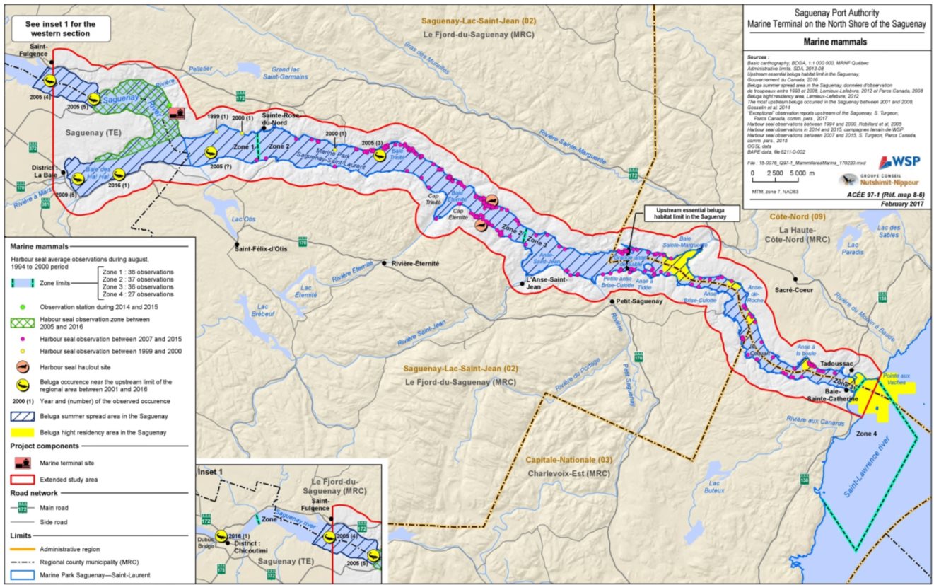
Source: WSP/GCNN, March 2017
7.4.2 Assessment of effects by the proponent
Anticipated effects
The proponent considers that the potential effects on marine mammals are essentially associated with the work that may generate underwater noise during construction of the wharf (blasting, pile driving, drilling of the pile sockets and installation of the sheet piling), with the noise generated by ships and the risk of collisions with ships during the operational phase (WSP/GCNN, mai 2016). These effects could modify the behaviour of marine mammals, possibly inducing avoidance of the area, or cause injuries or mortality.
The proponent concludes that the residual effects on marine mammals will be non-significant during the construction and operational phases (WSP/GCNN, mars 2017), mainly owing to the infrequent use of the local study area by marine mammals. Sightings of belugas are apparently rare and, although seals are observed more regularly, the local study area does not appear to contain any haulout or breeding sites for this species. The proponent considers that noise or the presence of ships would reduce the likelihood of marine mammals being present in the area. Construction-related noise would be perceived only near the project site. In addition, the proponent considers that the effects on the underwater acoustic environment during the construction and operational phases would be reversible, since they would be limited to the duration of noisy work or the presence of a ship.
Modification of behaviour or injury – blasting and noise
The proponent indicates that the noise produced during blasting, driving and drilling work could exceed the sound levels of the natural acoustic environment and induce effects (avoidance of the area, injuries or mortality) on marine mammals potentially present in the local study area, especially on the beluga, which uses a wide range of sounds to communicate and for echolocation Footnote 24. The proponent considers that the planned mitigation measures, including stopping all work if a marine mammal is sighted within 600 metres and having a marine mammal observer on site at all times, will reduce the anticipated effects (WSP/GCNN, mars 2017).
The proponent indicates that, during the operational phase, the noise caused by vessels may also modify the natural acoustic environment and induce effects on marine mammals. According to the scenarios assessed by the proponent, the project would result in one or two ships a week docking at the wharf to meet the needs of the Arianne Phosphate mining company, and two or three ships a week under the maximum operation scenario involving several clients. The proponent conducted a study on the effects of the increase in ship traffic on the underwater acoustic environment in the Saguenay River (WSP, octobre 2017). According to this study, the exposure of belugas to noise from ships would temporarily exceed the limit of 120 decibels reported as potentially influencing their behaviour (Southall et al., 2007; Lesage et al., 2014). The duration of noise perceptible by belugas during the passage of a ship would be 17 minutes on average, most of which would be below 120 decibels, but with levels as high as 154 decibels.
The proponent's data suggest that the propagation of sound, in both the vertical and horizontal axis, is accentuated by reverberation off the rocky walls of the Saguenay River. In the horizontal axis, the noise of large ships would be perceptible over 3.2 kilometres on average when approaching a fixed point, a beluga for example, and over 4.4 kilometres when moving away from it. However, this propagation is limited to low frequencies, since high-frequency waves propagate less easily in water.
According to the proponent, belugas use audible sounds, of low and medium frequencies, to communicate, as well as very high frequency sounds (ultrasound), inaudible to humans, called clicks or buzzes, for echolocation and detection. This marine mammal also perceives sounds over a wide frequency band, with greater sensitivity for high frequencies (ultrasound). Consequently, the proponent indicates that ships which emit high frequencies are likely to affect the acoustic functions of belugas. However, the proponent concludes that the effects of these high frequencies on belugas would be non-significant, since high frequencies do not propagate over long distances (WSP, October 2017).
The proponent indicates that the project-related practices and operational procedures which would be implemented would provide guidelines and oversight for vessel movements and would mitigate the potential effects of noise on marine mammals.
Injury or mortality – collisions with ships
According to the proponent, the increase in ship traffic in the Saguenay River could potentially result in an increase in collisions with marine mammals, particularly the St. Lawrence beluga, and cause direct injuries resulting in mortality (WSP, October 2017). The proponent indicates that these collisions are more frequent where marine mammals concentrate, and where ship traffic is higher. In the event of a collision, the speed of the ships is closely correlated with the seriousness of the injuries as well as with individual mortality. According to the proponent, the literature indicates that most lethal or serious injuries in cetaceans are caused by ships with a minimum length of 80 metres as well as by ships moving at speeds greater than 14 knots (approximately 26 kilometres per hour), which could correspond to the ships that would use the planned wharf. The victims of collisions are usually newborns or gestating females. The proponent reports that it is not necessarily easy for a whale to detect the presence of moving ships despite the sound that they emit, in part owing to the masking Footnote 25 of sounds by ambient noise and reduction of the hearing acuity of whales related to long-term exposure to noise of anthropogenic origin, particularly in areas with heavy ship traffic. A ship's main sound source is the propeller, which is located at the stern of the vessel. When the cetacean is at the bow, this sound source is less pronounced. Indeed, the ship's hull creates a physical obstacle to the propagation of the sound of the propeller toward the bow of the ship, thus creating a sound deadening zone in front of the bow, where the risk of collision is the greatest (WSP, October 2017). However, the proponent reports that, according to the Fisheries and Oceans Canada science advisory report (DFO 2014), the risks of collision with large, slow-moving vessels are low given the beluga's high maneuverability and very acute hearing. The proponent therefore considers that the risks of collision with a ship in the local study area would be low, given the low probability that marine mammals will be present in the local study area and the fact that the ships would be travelling at low speed since they would be engaged in docking Footnote 26 or undocking Footnote 27 maneuvers (WSP/GCNN, mars 2017).
Mitigation and follow-up measures proposed by the proponent
The proponent indicates that, during the construction phase, the objective of the mitigation measures would be to allow marine mammals to move toward the areas upstream or downstream of the project site without being exposed to any disturbances related to the project's noise-generating activities (vibratory pile driving, drilling and blasting). Given the currents and the steep banks at the planned site for construction of the port infrastructures, several noise mitigation measures, such as work in cribs, would be technically or economically unfeasible in the context of the project. Where applicable, the installation of an air bubble curtain could be considered if warranted by the frequent presence of marine mammals. However, since the presence of belugas is rare in the vicinity of the planned construction zone, the proponent recommends instituting simple and easily attainable measures as a first step, i.e.:
- Institute visual monitoring of the presence of belugas within a 600-metre exclusion zone, although this zone could be smaller depending on the construction methods chosen and the sound intensities generated. This monitoring would be carried out by qualified personnel, with the goal of suspending the work as soon as a beluga entered the exclusion zone. Work would be resumed only after a continuous 30-minute period of absence of marine mammals in the exclusion zone;
- Gradually begin noisy work, such as drilling, vibratory pile driving and pile driving, so that marine mammals have an opportunity to move away from the critical zone;
- Do not carry out any pile driving during the hours of darkness or on stormy days;
- For blasting work in proximity to the Saguenay River, detonate scaring charges (progressive increase in strength, detonator caps or short lengths of detonating cord), one minute before setting off the main charge, in order to encourage marine mammals to move away from the site.
The proponent proposes to carry out real-time monitoring of the noise emitted by construction activities for the first two weeks of noisy in-water work. This monitoring would make it possible to validate the results of the simulations and to determine any necessary corrective measures. During the operational phase, the proponent proposes to measure the underwater noise associated with ship-loading operations for a duration of approximately 30 hours, i.e. the time required to load a ship.
7.4.3 Comments received
Government authorities
Fisheries and Oceans Canada is of the opinion that construction of the terminal on the north shore of the Saguenay should not cause any residual effects on marine mammals in the local study area, since the effects of the project can be mitigated oravoided, particularly through the implementation of noise reduction measures and the establishment of a marine mammal protection and monitoring zone.
Fisheries and Oceans Canada is also of the opinion that the mitigation measures proposed by the proponent are still somewhat general at this stage and need to be developed in greater detail. The noise reduction measures, a protection zone and an appropriate monitoring radius for marine mammals (cetaceans and seals) will have to be determined based on the sound levels generated by the work methods to be used during the project, for example for pile driving and drilling. Fisheries and Oceans Canada recommends that the measures be determined based on the goal of ensuring that the animals are not exposed to a cumulative level of exposure over 24 hours greater than 178 decibels re 1 µPa2 –s (SELcum), and 181 decibels re 1 µPa2 –s (SELcum) for seals, which would make it possible to prevent injuries, such as damage to the inner ear causing temporary deafness.
Fisheries and Oceans Canada indicates that uncertainties remain concerning the effects of the blasting work since, at the time the environmental assessment was conducted, the detailed engineering was not sufficiently advanced to identify the specific work methods. However, Fisheries and Oceans Canada believes that these uncertainties can be managed through the authorization process under the Fisheries Act and that additional measures could be required.
With respect to the operational phase, Fisheries and Oceans Canada considers that the effects related to ship movements in the local study area have been satisfactorily assessed by the proponent. According to Fisheries and Oceans Canada's analysis, masking and disturbance effects are possible during the passage of freighters in the areas used by belugas. Marine mammals make intensive use of sounds for vital functions, such as the acoustic perception of their environment, navigation, communication and echolocation to hunt their prey.
The effects of ship traffic can result in a shrinkage over time and in space of the habitat that can be optimally used by belugas. This can translate into lost opportunities, i.e. less time or less space to forage or to forage efficiently, to detect or communicate with other whales or to detect dangers. Cumulative repetition of these lost opportunities over several days or during crucial periods of the annual cycle can lead to measurable effects on vital parameters such as the ability to reproduce, eat and take care of the young.
According to the Fisheries and Oceans Canada science advisory (MPO, mars 2018), the frequency and duration of changes in ambient sound conditions are indicators of the potential disturbance of belugas. The time during which the noise produced by a passing freighter is clearly distinguished from the ambient noise is estimated at 34 minutes for the frequencies used by belugas for communication and 14 minutes for the frequencies used for echolocation. The proponent's estimates of the percentage of exposure time to the noise generated by ships (WSP, octobre 2017) are generally comparable to the estimates produced by Fisheries and Oceans Canada experts (MPO, mars 2018), although different methodologies were used.
Concerning the risk of collision associated with the increase in the number of large-tonnage ships, Fisheries and Oceans considers this risk low for belugas and seals in the local study area since the ships would be moving at low speeds to carry out docking and undocking maneuvers.
Fisheries and Oceans considers that reduced vessel speeds in the immediate area of the terminal would reduce the risk of collisions with marine mammals (beluga whales, seals) and that the collision risk associated with an increase in the number of large vessels would be low for the beluga whale in the local study area.
In the opinion of the specialists of the Ministère du Développement durable, de l'Environnement et de la Lutte contre les changements climatiques du Québec, the probability of finding harbour seals in the local study area is greater than estimated by the proponent in the environmental impact statement, which indicates a low probability of occurrence. The proponent has corrected this information and confirms that the probability of occurrence of harbour seals in the local study area is somewhat higher than initially estimated. This information is based on observations of seals in the baie des Ha! Ha! made during surveys not specific to marine mammals (WSP/GCNN, mars 2017).
The ministère du Développement durable, de l'Environnement et de la Lutte contre les changements climatiques specialists participated in the analysis, but indicated their limited expertise in understanding certain issues related to marine mammals, including beluga habitat or underwater noise. In these cases, these experts rely on their federal counterparts. However, since the beluga is a threatened wildlife species under the Quebec's Act respecting threatened or vulnerable species, this issue remains fundamental and the ministère du Développement durable, de l'Environnement et de la Lutte contre les changements climatiques emphasizes its interest in keeping informed on the opinions on these subjects.
First Nations
The Innu Essipit, Pekuakamiulnuatsh (Mashteuiatsh), and Innu of Pessamit First Nations are concerned about the situation of the beluga. These Innu Nations emphasized the importance of conducting beluga monitoring during the project, requesting that work be suspended if an animal is seen within 600 metres of the work area, as proposed by the proponent (Agence, octobre 2016). They also raised concerns about the effect of the ships on echolocation and on mother and calf bonding. The proponent conducted a study on underwater noise (WSP, octobre 2017) and provided an update of its assessment of the cumulative effects on the beluga at the Agency's request (WSP/GCNN, décembre 2017).
The Huron-Wendat Nation is concerned about the overall effect of the project on the beluga, although it notes that it is possible that for the local study area, no direct effect is anticipated. Due to the Beluga's sensitivity to vessel movement in its habitat, the increase in marine traffic generated by this project could potentially affect this species. The Nation wishes to participate in the follow-up activities that will be carried out in connection with the beluga whale (Nation huronne-wendat, avril 2018).
Public
Concerns were raised about the potential effects of the addition of 120 project-related ship movements, i.e. 60 round-trips annually over a distance of nearly 100 kilometres in the Saguenay River, over and above the current freighter traffic directly in the critical habitat of the beluga, a species recently designated endangered (Bouchard, octobre 2016).
Members of the public have reported and documented the occasional presence of belugas in the Anse à Pelletier area, not far from the project site (Collectif de l'Anse à Pelletier, octobre 2017; Lord, octobre 2016). The proponent corrected the information initially presented in the environmental impact statement based on the available scientific data sources, in order to take the knowledge of local communities into account. In fact, the initial environmental impact statement indicated that the beluga sightings farthest upstream in the Saguenay River were located approximately 5 kilometres downstream of the project site.
The GREMM indicated that it agrees with the proponent that the potential effects of the construction and operation of the terminal on St. Lawrence belugas may be considered low and non-significant in the local project area. However, it raised concerns about the adverse effects of the increase in ship traffic on the beluga in the Saguenay River, and about how the proponent has addressed the issue of cumulative effects (GREMM, octobre 2016). The proponent conducted a study on underwater noise (WSP, octobre 2017) and provided an update of its assessment of the cumulative effects on the beluga at the Agency's request (WSP/GCNN, décembre 2017). The cumulative effects on the beluga are addressed in section 8.3.
The Conseil régional de l'environnement et du développement durable du Saguenay – Lac-Saint-Jean (CREDD) considers that, given the current level of uncertainty and the lack of information about the effects of noise on the beluga and the harbour seal, and given the special protection status of the beluga, the residual effects should be considered moderate and significant by the proponent.
The CREDD asked the proponent to justify the proposed distance of 600 metres for the monitoring of marine mammals during the work on the basis of data obtained from simulations and the scientific literature. The proponent indicated that this distance would be reviewed based on the construction methods chosen and the sound intensities generated in order to prevent noise effects on marine mammals. The CREDD recommends that the effectiveness of a marine mammal observer be demonstrated in the environmental impact statement and if necessary supplemented by new monitoring methods. The CREDD recommends monitoring the noises emitted during the construction phase in order to ensure that the mitigation measures are effective and that the thresholds for marine mammals are not exceeded. The proponent proposes conducting real-time monitoring of the noise emitted during the construction phase and taking corrective action to minimize the noise if necessary.
7.4.4 Agency analysis and conclusion
Analysis of the effects
Taking into account the implementation of the key mitigation measures indicated below, the Agency considers that the project is not likely to cause significant adverse effects on marine mammals, including special-status species. The construction and operation of the marine terminal would not adversely affect the recovery of the St. Lawrence beluga in the project's local study area. In this area, the project would not modify the habitat in such a way as to cause changes in the behaviour of belugas and harbour seals that would have an effect on regional population dynamics. In addition, the project site would be located outside the critical beluga habitat. However, the ships that would access the project site are expected to pass through the critical habitat on their way to and from the project site. The cumulative effects on the St. Lawrence beluga are addressed in section 8.3.
The Agency notes that certain behavioural effects on marine mammals attributable to the underwater noise caused by the work would occur throughout the construction phase, i.e. over a two-year period. The effects of noise would also be perceived in the local study area during the loading of ships, for a period of approximately 30 hours per ship, as well as during the passage, docking and undocking of ships, for the entire operational lifetime of the project. The effects would not occur during the winter, since belugas are not present in the Saguenay River at that time. The Agency has also considered the fact that the local study area is not used frequently by belugas during the summer period, since they are more present in and around the river mouth and Sainte-Marguerite Bay, and that the local study area does not include any haulout sites or rest areas for harbour seals.
It is possible that marine mammals will avoid the local study area during the construction phase and when ships are docked at the wharf during the operational phase owing to the effects of auditory masking (when a sound is rendered inaudible by another) and noise disturbance. The Agency relies on the opinion of Fisheries and Oceans Canada, which considers that the establishment of measures to reduce underwater noise as well as a marine mammal protection and monitoring zone during the work would, and stopping these works when marine mammals enter the area, would reduce the risks. The Agency expects that the proponent will consult and obtain the approval of Fisheries and Oceans Canada in order to establish measures to be put in place so that so that marine mammals are not exposed to a cumulative level of exposure over 24 hours greater than 178 decibels re 1 µPa2 –s (SELcum) for belugas, and 181 decibels re 1 µPa2 –s (SELcum) for seals.
With respect to the direct mortality and injuries that belugas and harbour seals could suffer owing to blasting during the construction phase, the Agency has relies on the opinion of Fisheries and Oceans Canada, which indicates that these effects could be avoided by the implementation of a blasting plan and appropriate mitigation measures, which would be determined during the regulatory compliance process under the Fisheries Act.
With respect to the risks of injuries or mortality attributable to collisions with passing ships, the Agency relies on the opinion of Fisheries and Oceans Canada indicating that the risks would be low in the local study area. The Agency considers that the ships approaching or departing from the terminal will be travelling at reduced speed. The Agency also considers that the limited number of project-related ships and the infrequent presence of belugas and harbour seals in the local study area, although seals are observed more frequently, reduce the risks of collisions.
The Agency has relied on the opinion of Fisheries and Oceans Canada in concluding that the sound levels likely to be generated can be mitigated by the implementation of noise reduction measures and, moreover, that the risks of collision are low. The uncertainty concerning the effects of blasting in the terrestrial environment would be addressed during the authorization process under the Fisheries Act. The Agency concludes that the adverse environmental effects attributable to noise disturbance would be of low intensity, particularly owing to the infrequent presence of marine mammals in the area. Although these effects would be present for the entire operational lifetime of the project, they would be limited to the local study area, which represents a small part of the range of the St. Lawrence beluga and harbour seal populations that use the Saguenay River and the St. Lawrence Estuary.
Key mitigation measures to avoid significant effects
- Prior to commencement of construction in the marine environment and in consultation with Fisheries and Oceans Canada, develop measures to avoid exposing beluga whales, harbor seals and fish to greater than 178 decibels re 1 μPa2 -s (SELcum) for the beluga and 181 dB re 1 μPa2 - s (SELcum) for the harbor seal and 183 dB re 1 μPa2 - s (SELcum) for the fish. Develop these measures and identify the circumstances during which each exposure level should not be exceeded, including according to work methods used, predicted levels of underwater noise to be generated by underwater construction activities and the periods of the year during which these activities take place. Notify the Agency, prior to construction in the marine environment, of these measures and of the circumstances during which each exposure level shall be maintained and implement these measures throughout the construction phase in the marine environment, unless otherwise authorized by Fisheries and Oceans Canada. Among other measures, develop and implement gradual start up procedures for drilling, vibratory pile driving and pile driving activities to give marine mammals an opportunity to move away from the sources of underwater noise.
- Prior to commencement of construction in the marine environment and in consultation with Fisheries and Oceans Canada and the Innu Essipit, Pekuakamiulnuatsh (Mashteuiatsh), and Innu of Pessamit First Nations, as well as the Huron-Wendat Nation, develop and implement, throughout the construction phase in the marine environment, a visual monitoring program for belugas and harbour seals. As part of the visual monitoring program:
- Prior to commencement of construction activities in the marine environment, carry out predictive acoustic modelling in order to determine what distance each construction activity in the marine environment would cause a cumulative level of exposure to underwater noise over 24 hours equal or greater than 178 decibels re 1 µPa2 –s (SELcum) for the beluga, and equal or greater than 181 decibels re 1 µPa2 –s (SELcum) for the harbour seal, including activities occurring simultaneously, and the period or periods during which these activities would occur. Submit the predictive acoustic modelling results to the Agency before undertaking these construction activities in the marine environment;
- Based on the results of the predictive acoustic modelling carried out, establish and maintain during construction in the marine environment, protection zones corresponding to the distances fromthe construction activities at which the cumulative level of exposure to underwater noise over 24-hour are always less than 178 re 1 µPa2 –s (SELcum) for the beluga and less than 181 re 1 µPa2 –s (SELcum) for the harbour seal;
- Require that observers, who are qualified to carry out the observation of marine mammals, perform continuous visual monitoring of the protection zones and report to the proponent the presence of a beluga or a harbour seal within its respective protection zone during each construction activity in the marine environment;
- If a beluga or harbour seal is observed in itsrespective protection zone by the marine mammal observers, halt or delay the commencement of construction activities in the marine environment until the beluga or harbour seal has left its respective protection zone and no beluga or seal has been observed in itsrespective protection zone for a continuous period of at least 30 minutes;
- Do not annoy or harass in any way beluga whales or harbour seals present within their respective zone of protection in order to remove them from the protection zones;
- Carry out drilling, vibrating and piling only during daylight hours and not under conditions of low visibility (including fog).
- Submit quarterly to the Agency, starting from the month during the beginning of the construction in the marine environment and throughout construction in the marine environment, the results of the activities carried out as part of the visual monitoring program for belugas and harbour seals. Submit these results to the Agency no later than 30 days following the end of the period to which they apply;
- Develop, to the satisfaction of Fisheries and Oceans Canada and in consultation with the Innu Essipit, Pekuakamiulnuatsh (Mashteuiatsh), and Innu of Pessamit First Nations, as well as the Huron-Wendat Nation, any offsetting plan (s) to address any residual serious harm associated with the implementation of the project. Submit any approved offsetting plan(s) to the Agency prior to implementation;
- If any offsetting measure(s) proposed in any offsetting plan(s) may cause adverse environmental effects not considered in the environmental assessment, develop and implement, following consultation with the Innu Essipit, Pekuakamiulnuatsh (Mashteuiatsh), and Innu of Pessamit First Nations, as well as the Huron-Wendat Nation and relevant authorities, measures to mitigate those effects. Submit these measures to the Agency before implementing them.
Need for and requirements of follow-up
The Agency considered the mitigation measures proposed by the proponent, expert advice from federal authorities as well as the comments received from the First Nations consulted and the public to determine the following follow-up program intended to verify the predicted effects on marine mammals and the effectiveness of the mitigation measures:
- Prior to commencement of the construction activities in the marine environment and in consultation with the Innu Essipit, Pekuakamiulnuatsh (Mashteuiatsh), and Innu of Pessamit First Nations, as well as the Huron-Wendat Nation and Fisheries and Oceans Canada, develop a follow-up program in order to verify the accuracy of the environmental assessment and determine the effectiveness of the mitigation measures in addressing the adverse environmental effects ofterrestrial blasting and underwater noise on fish and marine mammals. Implement the follow-up program during the construction and operational phases (same monitoring as for fish). During the implementation of the follow-up program:
- Conduct real-time monitoring, for the first 14 days of construction, of the levels of underwater noise emitted by the drilling, pile driving and vibratory pile driving activities and bank blasting activities to validate the results of the acoustic simulations carried out for these activities during the environmental assessment;
- Carry out, once during the first year of operation, real-time monitoring of the levels of underwater noise emitted by ship-loading activities, for the period of time required to load a ship;
- Submit the monitoring results to the Agency and to Fisheries and Oceans Canada no later than 30 days following the end of each monitoring period.
7.5 Birds, Including Special-Status Species
Analysis of the effects on birds covers migratory and non-migratory birds, their eggs, nests and habitats, including the special-status species listed under federal and provincial legislation. Migratory birds include landbirds Footnote 28, shorebirds, waterbirds and waterfowl listed in the schedule of the Migratory Birds Convention Act, 1994. Some of these species are listed in Schedule 1 of the Species at Risk Act or are designated under the Quebec Act respecting threatened or vulnerable species.
According to the Agency, significant residual adverse effects are caused by habitat loss and deterioration, incidental take Footnote 29, or any nuisance likely to result in the decline of a bird population or to hinder the recovery of one or more species at risk subject to a recovery strategy within the meaning of the Species at Risk Act or that have special status according to the Quebec Act Respecting Threatened or Vulnerable Species. The criteria for assessing environmental effects and the grid for determining the significance of effects used by the Agency are provided in Appendices A and B, respectively.
Following completion of its analysis, and taking into account the implementation of the mitigation measures, the Agency concludes that the project is not likely to cause significant adverse environmental effects on birds, including special-status species:
- The permanent and temporary losses of bird habitat would total 39 hectares and would potentially affect 163 breeding pairs. These losses would not result in any effects that would hinder the recovery of one or more species at risk within the meaning of the Species at Risk Act or that have a conservation status under the Act Respecting Threatened or Vulnerable Species, and there are also a number of alternative habitats in the area;
- It is unlikely that the project will result in the mortality of migratory birds (incidental take) or the destruction of their nests or eggs. The disturbance would be limited to the project site. Tree and brush removal will take place outside the nesting period and particular attention will be paid during this work.
The following subsections describe the baseline conditions, particularly the habitats likely to be used by birds, and the essential elements of the proponent's analysis. They present the opinions of the expert departments as well as of the First Nations consulted and the public on which the Agency based its conclusions concerning the significance of the project's effects on birds, including special-status species.
7.5.1 Baseline conditions
The proponent defined two main spatial boundaries to describe the current conditions and analyze the anticipated environmental effects on birds. A regional study area, corresponding to the section of the Saguenay River and its banks located between the Dubuc Bridge (approximately 27 kilometres upstream of the project site) and Sainte-Rose-du-Nord (approximately 12 kilometres downstream of the project site), was established for migratory birds, including special-status birds. A zone of influence of the project (Figure 12), corresponding to a 2-kilometre zone around the periphery of the planned infrastructures, was also established for all the birds that may be affected by the project (WSP/GCNN, mai 2016). The proponent also makes reference to the limited study area, which corresponds to the boundaries of the project site.
In order to draw up an accurate picture of the bird species that use the regional study area, the proponent relied on various existing data sources, conducted surveys using point count stations and noted observations during field visits in the forest. Based on all the data analyzed, 123 bird species may potentially be present in the regional study area on an annual basis.
In the limited study area identified in Figure 12, 91 species were counted during all the field surveys conducted by the proponent. A total of 55 species were observed during the nesting period, 31 species during the spring migration period and 37 species during the fall migration period. With respect to landbirds more specifically, the estimated population varies between 673 and 1,962 indicated pairs for the regional study area. Three birds of prey, 25 waterfowl species as well as six other waterbird species were observed (WSP/GCNN, mai 2016).
The proponent identified eleven special-status bird species (threatened or vulnerable or likely to be so designated, at risk, or identified by the Committee on the Status of Endangered Wildlife in Canada) likely to be found in the regional study area, during both the nesting and migration periods (Table 7) (WSP/GCNN, mai 2016; WSP/GCNN, août 2016). Three special-status species were observed during the proponent's surveys, namely the Bald Eagle and the Rusty Blackbird, which were observed only during the migration period, and the Canada Warbler, which was observed during the nesting period. The project site, as well as the project's zone of influence, also contains several potential nesting habitats for the Canada Warbler. According to the proponent, Chimney Swifts may occur in the project's zone of influence, but no potential habitat was identified in the limited study area. For the Barn Swallow, only a low nesting habitat potential was identified in a grass bed located at the edge of the Saguenay River (WSP/GCNN, décembre 2017). Despite the fact that the limited study area and the project's zone of influence contain several hectares of potential habitat for the Eastern Wood Peewee, no individuals were observed during the surveys.
|
Species |
Federal status – Species at Risk Act |
Federal status – COSEWICTable 7 Note 1 |
Provincial status – Quebec Act respecting threatened or vulnerable species |
|---|---|---|---|
|
Bald Eagle |
None |
Not at Risk |
Vulnerable |
|
Rusty Blackbird |
Special Concern |
Special Concern |
Likely to be designated threatened or vulnerable |
|
Canada Warbler |
Threatened |
Threatened |
Likely to be designated threatened or vulnerable |
|
Nelson's Sharp-tailed Sparrow |
None |
Not at Risk |
Likely to be designated threatened or vulnerable |
|
Short-eared Owl |
Special Concern |
Special Concern |
Likely to be designated threatened or vulnerable |
|
Barn Swallow |
Threatened |
Threatened |
None |
|
Chimney Swift |
Threatened |
Threatened |
Likely to be designated threatened or vulnerable |
|
Least Bittern |
Threatened |
Threatened |
Vulnerable |
|
Eastern Wood Peewee |
Special Concern |
Special Concern |
None |
|
Yellow Rail |
Special Concern |
Special Concern |
Threatened |
|
Peregrine Falcon |
Special Concern |
Not at Risk |
Vulnerable |
Table Notes
- Table 7 Note 1
-
COSEWIC: Committee on the Status of Endangered Wildlife in Canada.
The forest environments likely to be used by birds in the project's zone of influence include deciduous forests and deciduous-dominated mixed forests, the habitat that covers the largest area (60.5%), followed by coniferous-dominated mixed forests (13.7%) and coniferous forests (25.8%). Small wetlands are also present within these forest habitats. The proponent indicates that there are no open wetlands near the project, only three forested peat bogs are present and a few intermittent streams under forest cover. Figure 12 provides a breakdown of the terrestrial and wetland environments in the project's zone of influence.

Source: WSP/GCNN, May 2016
7.5.2 Assessment of the environmental effects by the proponent
Anticipated effects
According to the proponent, the adverse effect of the project on birds, including special-status species, is potentially related to:
- The habitat loss resulting from the tree and brush removal required for construction of infrastructure, access roads and fill areas;
- Disturbances owing to noise and light (presence of infrastructure and ships) and the risk of mortality (collisions).
Habitat loss
The proponent indicated that habitat loss is the main effect caused by the project on birds. The magnitude of these habitat losses is considered low to medium, even though the tree and brush removal will take place in winter, thereby avoiding the nesting period. The proponent considers that the residual effects of the project on birds would be non-significant, given the small area affected. Two types of habitats could be affected, namely deciduous forests or deciduous-dominated mixed forests and coniferous forests. A total of 163 breeding pairs of 45 species of forest birds could potentially be affected by the habitat loss, which represents 23.15 hectares in the deciduous forests and deciduous-dominated mixed forests and 16.23 hectares in the coniferous forests. The species that have the largest number of breeding pairs affected in the deciduous forest and deciduous-dominated mixed forest habitat are Swainson's Thrush, the Red-eyed Vireo and the Bay-breasted Warbler. The species the most affected in the coniferous forest habitat are the Tennessee Warbler, the Bay-breasted Warbler and the Nashville Warbler (WSP/GCNN, mai 2016).
In terms of special-status species, only the Canada Warbler was surveyed during the nesting period and four breeding pairs would be affected by the loss of 23.18 hectares of forest habitat (WSP/GCNN, mai 2016). The Eastern Wood Peewee, the Chimney Swift and the Barn Swallow could also be affected, since they may be present in the project's zone of influence.
The proponent concludes that the habitat losses would have non-significant effects on birds since other nesting sites are available nearby. According to the proponent, large contiguous forest tracts are available around the periphery of the project site and these habitats are generally not saturated in the regional study area. The proponent supported this argument with additional details concerning the Canada Warbler (WSP/GCNN, mars 2017) by extrapolating the percentage of alternative habitats available around the area of disturbance associated with the project site based on the characteristics of suitable habitats for the species. According to the proponent, these alternative habitats represent 32% of the occupancy rate of the available habitats in proximity to the work zone.
On the whole, the proponent considers the magnitude of the project's residual effects on the Canada Warbler to be significant during the construction phase and non-significant during the operational phase (WSP/GCNN, décembre 2017). Despite the significance of the residual effects for this component, the proponent stresses that the effects will be limited to the cleared area and that several alternative habitats are available around the periphery of the project site.
Given the absence of potential habitat on the project site for the Chimney Swift and the low potential habitat for the Barn Swallow, the proponent does not anticipate any effects on these species, particularly since the probability of their presence in the few potential habitats identified in the project's zone of influence is low (WSP/GCNN, mai 2016).
Disturbance
Noise, caused by infrastructure construction and traffic on the construction site, and the refueling and maintenance of machinery, could result in avoidance of certain noisy areas by birds, a reduction in the breeding success of certain species, as well as changes in terms of interspecies communication. Noise and vibrations from blasting could be perceived beyond the limited study area. Birds could avoid the work zone during blasting operations. This could have repercussions on the breeding of individuals by limiting the number and diversity of the species potentially present in the work zone. During the operational phase, the noise effect zone would be mainly related to the presence of the conveyor, unloading and storage areas, and transhipment activities on the wharf and vehicle traffic. However, the noise effect zone will not extend beyond the project's zone of influence. The probable effects of noise in the terrestrial environment will be related to machinery use. Consequently, the proponent expects that avoidance of the area by birds will be localized mainly in the limited study area and a few hundred metres around its periphery.
Disturbances caused by lighting are also anticipated during the operational and maintenance phase, particularly during ship loading operations. This night-time lighting could have an effect on migrating birds, by attracting groups of birds to the operations and diverting them from their migration route. This could happen particularly during foggy conditions, resulting in a collision-related mortality risk. However these effects are considered of minor significance by the proponent, since the project would cause little intrusive light in the terrestrial environment or toward the Saguenay River, taking into account the mitigation measures that would be implemented in order to reduce the adverse effects. In addition, the proponent considers that collisions with the type of infrastructure planned (buildings and ships) would be infrequent events. The proponent considers that, on the whole, the effects of noise and light disturbance would be minor, since they would be perceived discontinuously during the construction and operation periods and since alternative habitats are available nearby (WSP/GCNN, mars 2017).
Mitigation and monitoring measures proposed by the proponent
In order to reduce the adverse environmental effects on birds, the proponent undertakes to implement mitigation measures aimed at minimizing tree and brush removal, noise and light. The main mitigation measures are listed below (see Appendix E for the complete list):
- No tree and brush removal work to be carried out between April 15 and August 15, in order to avoid the bird nesting period;
- Clearly delimit the work areas at the site of the tree and brush removal activities in order to prevent any additional encroachment;
- Revegetate the infrastructures used temporarily during the construction and layout of the site immediately after the end of the construction phase;
- Limit skyward light emissions by using light fixtures that produce moderate, uniform lighting that will meet actual lighting needs and by ensuring that the luminous flux is directed toward the surface to be illuminated; The proponent points out that the light fixtures will not produce any light emissions outside an arc of 90 degrees and that particular attention will be paid in order to avoid orienting the portable lights from mobile sources toward the Saguenay River;
- Minimize insofar as possible the period and duration of use of lighting by installing timers and motion sensors and by encouraging workers to turn off the lights. The lighting will be planned in order to ensure a level of light required for worker safety and the safe operation of equipment, while minimizing the luminous flux. When possible, light sources will be turned off in the areas where lighting is not required permanently;
- Limit the movement of machinery and truck traffic to the right-of-way of access roads and work areas;
- Require that the construction site supervisor ensure the proper maintenance of noisy equipment and that the mufflers and catalytic converters of machinery be kept in good condition in order to minimize noise.
The proponent has agreed to implement an environmental monitoring and follow-up program in order to minimize the potential effects resulting from the implementation of the project on birds, which includes in particular the following actions:
- Monitor the work in order to ensure that no incidental take of nests or eggs occurs; the areas where the work will take place will first be inspected before authorizing the work (if during the nesting period);
- Institute an employee awareness and training program in order to inform employees about the presence of nests of migratory birds, including those of species at risk such as the Canada Warbler, and about the proper procedure to follow in the event that a nest is discovered;
- In the event that a migratory bird nest is discovered (early or late nesting species), the proponent proposes several measures, including:
- Stopping all disruptive activities near the nest until nesting is over, i.e. until the chicks have permanently left the nest;
- Clearly identifying the nest by its GPS position and protecting the nest by establishing a buffer zone based on a protection distance appropriate to the species. This distance will depend on the species and will be determined by an experienced biologist. The nest itself should never be marked with flagging tape, since this could increase the risk of predation of the nest. Flagging tape should therefore be placed at the limit of the buffer zone;
- Collecting the following data: the species, the habitat and the stage of development of the nest (construction, presence of eggs, of young);
- Carrying out monitoring visits. The observer in charge of the monitoring must take steps to ensure that any disturbance of the birds is minimized.
In order to determine whether specific mitigation measures are necessary to protect the Canada Warbler, the proponent proposes to conduct a bird survey in the summer of 2018, prior to implementation of the project. The purpose of this survey will be mainly to verify the presence of the Canada Warbler, but also to determine, when possible, its density and abundance. The survey results will serve as the baseline conditions, and will also make it possible to verify the intervention options for creating or improving habitat conditions favourable to certain special-status bird species on the project site during the restoration phase. After this survey, an initial follow-up aimed specifically at special-status species would be carried out through a survey after five years of operation, followed by a final survey in the tenth year of operation (WSP/GCNN, décembre 2017).
7.5.3 Observations received
Government authorities
On the whole, Environment and Climate Change Canada considers that the description of bird fauna is well documented and representative of the study area. Each of the major biotopes has been surveyed in a manner relatively proportional to their area occupied in the study area (Environment and Climate Change Canada, avril 2018).
The restriction period on tree and brush removal activities established by the proponent is representative of the critical nesting periods of the migratory birds present in the study sector. Environment and Climate Change Canada is of the opinion that if the proponent implements all the mitigation measures identified, including the monitoring and follow-up program, they will help minimize the project's potential effects on migratory birds. This department points out that the proponent must carry out the project in such a manner as to protect migratory birds and avoid injuring, killing, taking or disturbing migratory birds or destroying, disturbing or taking their nests or eggs. To this end, the proponent must take into account the Avoidance Guidelines issued by Environment and Climate Change Canada. The measures that the proponent will institute must also comply with the Migratory Birds Convention Act, 1994, the Migratory Birds Regulations and the Species at Risk Act.
With regard to the revegetation plan for temporary work areas, Environment and Climate Change Canada emphasizes that the planting methods and the species or groups of species used must be adapted to and take the natural conditions of the site into account. Revegetation can have an effect on the availability of habitats for migratory birds and species at risk. The revegetation work should take into account the different units of vegetation identified on the site in terms of species, arrangement and density of plants. For all revegetation work, the use of native species is required.
With respect to the Canada Warbler, a species at risk, Environment and Climate Change Canada is satisfied with the proponent's demonstration concerning the availability of suitable habitats for this species in the study area or near the site. However, Environment and Climate Change Canada is of the opinion that during the construction phase, and despite the application of mitigation measures, the tree and brush removal, grubbing, stripping and excavation activities would have residual adverse effects on the habitat of the Canada Warbler. Conducting surveys with reference stations in the study area before commencement of the work should make it possible to quantify the actual effects of the project on species at risk, and more particularly on the Canada Warbler.
Like the proponent, Environment and Climate Change Canada considers that no significant adverse effects are anticipated on the Chimney Swift or the Barn Swallow from the implementation of the project. Environment and Climate Change Canada is of the opinion that if the proponent maintains the measures and commitments that it has identified, the potential effects on the bird species at risk present in the study area resulting from the implementation of the project should be minimized.
Although the presence of the peregrine falcon has been reported by the public in the area of the Project and at the regional level by the proponent, Environment and Climate Change Canada has no specific concerns regarding the potential effects of the Project on this species since no potential habitat is present in the study area.
First Nations
With respect to migratory birds, the Innu First Nation of Essipit raised concerns about the environmental effects of marine transportation, including spills of petroleum products as a result of potential accidents, on migratory bird hunting practices along the Saguenay River (Conseil de la Première Nation des Innus Essipit, 2016). This aspect is covered in section 7.8 on current uses by Indigenous peoples and section 8.1 on accidents and malfunctions. Innu First Nations are concerned about habitat loss and the adverse effects of noise and light pollution on terrestrial wildlife and at-risk species such as Canada Warblers. They also believe that the effects of blasting on terrestrial wildlife are an issue.
The Huron-Wendat Nation emphasizes that it would be desirable for the proponent to protect 23.18 hectares of habitat near the project area in order to favor the Canada warbler population. Permanent protection would minimize the cumulative effects felt in the region, as other development projects will take place on the periphery of the area. In addition, the Nation indicates that it would be appropriate to have a monitoring program in order to validate the status of the Canada warbler population following the project. During the consultation period on the draft Environmental Assessment Report, the Huron-Wendat Nation raised concerns and dissatisfaction with the assessment of the Agency's effects on birds. According to the Nation, destroying 163 pairs of breeding birds is a significant potential effect and compensation measures for Canada Warbler should be established.
Public
Concerns were raised by the public about the destruction of migratory bird habitat. It was also pointed out that the Peregrine Falcon is sighted regularly in the area even though that species was not mentioned in the study (Bouchard, 2016).
The Conseil régional de l'environnement et du développement durable du Saguenay–Lac Saint-Jean (CREDD, 2016) questioned the methodology used to conduct the bird surveys. The CREDD mentioned that the point count stations did not cover the entire zone of influence of the project. The proponent indicated that the habitats were covered in proportion to their presence in the study area and that access to the land influenced the location of the point count stations, particularly in the sector with rugged terrain.
The CREDD is also concerned about how the proponent plans to comply with the Act Respecting the Conservation and Development of Wildlife in the event that there are Canada Warbler nests in the study area. The proponent indicated that concrete mitigation measures would be put in place if active nests of migratory birds are discovered. Workers will be made aware of the potential presence of nests, and if a nest is discovered, disruptive activity near the nest will be halted until nesting is complete. A protection area will be clearly marked, and the nest will be monitored.
The CREDD questioned whether birds would move back into the revegetated areas of the site after the construction phase and believes that a monitoring program should be put in place to track changes in bird species use near the project site. The proponent proposed to conduct a survey in the summer of 2018 in order to verify opportunities for intervention to create favourable habitat conditions or improve habitat conditions for certain special-status bird species on the project site or along its periphery during the restoration phase. Follow-up during the operation phase to target the actual causes of effects on special-status species is also proposed.
7.5.4 Agency analysis and conclusion
Effects analysis
The Agency is of the opinion that, taking into account the implementation of the key mitigation measures identified below, the project is not likely to cause significant adverse environmental effects on birds, including special-status species. Habitat losses would affect a small area, and the project would not hinder recovery of one or more species at risk that are subject to a recovery strategy within the meaning of the Species at Risk Act or that have special status under Quebec's Act Respecting Threatened or Vulnerable Species.
The project was optimized so as to minimize the adverse environmental effects on birds. Habitat losses would affect a small area, and similar habitats are available near the project site for any birds, including species at risk, that would be disturbed by the work or by terminal activities during the operation phase. In addition, the project's zone of influence does not include any habitat that is unique or critical for the survival of any bird species. Habitat losses on the project site would be irreversible, but the revegetation of sites used on a temporary basis for construction would reduce that effect.
With respect to species at risk, only the Canada Warbler, which was confirmed to occur on the site, could be affected during the nesting period. However, the Agency notes that the project would be carried out in a manner that protects and avoids harming, killing or disturbing migratory birds or destroying or taking their nests or eggs. That objective could be achieved in a number of ways, including by carrying out tree and brush removal in the winter outside the nesting period. Workers will also be made aware that nests could be discovered, and a buffer would be created to protect the nests until the birds and chicks have left. The Agency is of the opinion that noise and light produced by the project could deter birds from using the area or alter their behaviour. The Agency considers that these sensory effects would be localized and would extend throughout the life of the project. However, the mitigation measures proposed by the proponent would reduce the adverse environmental effects. The Agency concludes that the residual adverse environmental effects due to sensory disturbances would be low to moderate in magnitude.
The analysis of the significance of the Project's effects on the Canada Warbler during the operation phase took into account the threats identified in the Recovery Strategy for this species. The Agency relies on the advice of Environment and Climate Change Canada, which is satisfied with the Proponent's demonstration of the availability of suitable habitat for Canada Warbler in or near the study area or near the project's site. As a result, the Agency did not recommend habitat compensation as a key mitigation measure as requested by the Huron-Wendat Nation. However, the Agency has proposed the establishment of a bird monitoring program, which would include the Canada Warbler, and which would provide for a pre-construction inventory to verify the accuracy of the environmental assessment regarding the presence of Canada Warbler and other identified bird species.
Key mitigation measures to avoid significant effects
The Agency has determined the key mitigation measures needed to ensure that there are no serious adverse environmental effects on birds, including special-status species. The Agency has taken into consideration the mitigation measures proposed by the proponent, the opinion of government authorities, and input from the First Nations consulted and the public. These measures are as follows:
- Carry out the Project in a manner that protects migratory birds and avoids harming, killing or disturbing them or destroying, disturbing or taking their nests or eggs. In this regard, develop, prior to construction, in consultation with the competent authorities, and taking into account Environment and Climate Change Canada's Avoidance Guidelines Footnote 30, a migratory birds management plan which includes mitigation measures, including measures related to sensitive periods and locations for migratory birds, risk of incidental take, and actions to take if migratory birds or nests are found. Implement the migratory birds management plan. Actions implemented during the migratory birds management plan shall be in compliance with the Migratory Birds Convention Act, 1994, the Migratory Birds Regulations and the Species at Risk Act.
Need for and requirements of follow-up
The Agency considered the mitigation measures proposed by the proponent, expert advice from government authorities, and input from the First Nations consulted and the public in identifying the follow-up program below which are aimed at verifying the predictions of effects on migratory birds and the effectiveness of the mitigation measures:
- Develop, prior to construction and in consultation with the Innu Essipit, Pekuakamiulnuatsh (Mashteuiatsh), and Innu of Pessamit First Nations, as well as the Huron-Wendat Nation and the relevant authorities, a follow-up program to verify the accuracy of the environmental assessment and determine the effectiveness of the mitigation measures implemented in the Project area to avoid causing adverse environmental effects on birds, including migratory birds and their eggs and nests. As part of the development of the follow-up program, identify the bird species to be monitored. Implement the follow-up program during construction and operational phases of the Project, including the fifth and tenth years of the operation phase. As part of the implementation of the follow-up program:
- Conduct an inventory, using standardised inventory techniques, to verify, prior to construction, the accuracy of the environmental assessment as it relates to the presence of the Canada Warbler and other bird species identified in the areas where tree cutting will be carried out and in potential habitats located within the limited study area and in periphery of this area;.
- If modified or additional mitigation measures are required to protect the migratory birds identified during the inventory, develop these measures in consultation with the relevant authorities and implement these measures in a timely manner and monitor them. Submit these measures to the Agency before implementing them.
7.6 Special-status terrestrial mammal species
The Agency defines special-status terrestrial mammal species as non-aquatic species that receive legal protection or are considered under federal or provincial legislation (the Species at Risk Act (SARA) or the Act respecting threatened or vulnerable species (LEMV), respectively) or for which the Committee on the Status of Endangered Wildlife in Canada (COSEWIC) recommends a change in status or addition to the list of species at risk. Under subsection 79(2) of the Species at Risk Act, the Agency must identify the project's adverse effects on the mammal species that appear on the List of Wildlife Species at Risk (Schedule 1 of the Act) and their critical habitats. The Agency must also ensure that measures are taken to prevent, mitigate and control adverse effects on species at risk and that the appropriate monitoring and follow-up programs are implemented if the project is carried out. The measures must be consistent with all applicable recovery strategies and action plans.
In its analysis of the project's effects on special-status terrestrial mammal species, the Agency focused on habitat loss, mortality and disturbance of the animals' movements. The special-status species considered are three species of bats designated endangered under SARA, namely the tri-coloured bat, the little brown myotis and the northern myotis, and four species likely to be designated threatened or vulnerable under LEMV, namely the silver-haired bat, the hoary bat, the Eastern red bat and the rock vole. The Agency's criteria for evaluating environmental effects and its grid for determining the significance of the effects are shown in Appendices A and B, respectively.
According to the Agency, a significant residual adverse effect on special-status terrestrial mammals is an effect that would hinder recovery of one or more species at risk which have final recovery strategies under SARA or special status in Quebec under LEMV: in this case, the loss or disturbance of critical bat habitat (hibernacula Footnote 31).
In its analysis, the Agency concluded that, with the application of mitigation measures, the project is not likely to cause significant adverse environmental effects on special-status terrestrial mammals:
- The proponent's surveys of the potential sites did not detect any bat hibernacula or maternity roosts Footnote 32; hibernacula are considered critical habitat under the Species at Risk Act for the listed bat species.
- Acoustic surveys conducted during the breeding period revealed that, overall, there is little bat activity in the area.
- Tree-clearing activities could affect some areas that may be frequented by the rock vole and cause the deaths of individuals, without adverse effects on the species' population dynamics.
- The rock vole may be found over a large range in Quebec and has no legal protection status. The effects on this species may be reduced by implementing mitigation measures to protect watercourses and by avoiding wetlands.
The following subsections describe the baseline condition of the project area and the essential elements from the proponent's analysis. They also present the input from federal authorities, the First Nations consulted and the general public on which the Agency based its conclusions regarding the significance of the project's effects on special-status terrestrial mammals.
7.6.1 Baseline condition
Bats
The area surrounding the project site is potentially occupied by seven of the eight bat species found in Quebec (WavX, octobre 2017). These species are divided into two categories based on their behaviour: migratory and resident species (Table 8). In the fall, when weather conditions become harsher and the insects that bats feed on become scarcer, migratory bats fly south along the Atlantic coast, where they hibernate in hollow trees or layers of dead leaves; some even remain active. Resident bats spend the winter in Quebec and gather in hibernation sites known as hibernacula, which are usually underground habitats such as caves, abandoned mines or tunnels (WSP/GCNN, mai 2016).
A number of these species have special status under SARA, LEMV or COSEWIC (Table 8). Three of these species are endangered species, namely the tri-coloured bat, the little brown myotis and the northern myotis, are significantly affected by white-nose syndrome, which is thought to have caused a drastic decline in their populations. It is an infection caused by a pathogenic fungus, often characterized by the appearance of fuzzy white patches on the bats' muzzles.
It affects the bats' tissues and muscles and attacks the immune systems of affected individuals, often resulting in death. Any site where one of these three species of bats has been observed in hibernation during the winter at least once since 1995 is identified as critical habitat in the recovery strategy for these species established under the Species at Risk Act (Environment and Climate Change Canada, 2015).
|
Species |
Behaviour |
Federal status - Species at Risk Act |
Federal status – COSEWICTable 8 Note 1 |
Provincial status – Quebec Act respecting threatened or vulnerable species |
|---|---|---|---|---|
|
Silver-haired bat |
Migratory |
None |
None |
Likely to be designated threatened or vulnerable |
|
Hoary bat |
Migratory |
None |
None |
Likely to be designated threatened or vulnerable |
|
Eastern red bat |
Migratory |
None |
None |
Likely to be designated threatened or vulnerable |
|
Big brown bat |
Resident |
None |
None |
None |
|
Little brown myotis |
Resident |
Endangered |
Endangered |
None |
|
Northern myotis |
Resident |
Endangered |
Endangered |
None |
|
Tri-coloured bat |
Resident |
Endangered |
Endangered |
None |
Table Notes
- Table 8 Note 1
-
COSEWIC: Committee on the Status of Endangered Wildlife in Canada.
Resident bat species use hibernacula when weather conditions are harsh. In the area, three species of bats are likely to use hibernacula: the big brown bat, the little brown myotis and the northern myotis (WavX, mai 2017). However, no hibernacula were identified within the project's zone of influence or even beyond it. The proponent conducted field research to determine whether hibernacula were present on or near the planned worksite, including sites outside the limited study area, particularly near Lake Neil and in the cliffs along the Saguenay River near Cap à l'Est. Potential locations characterized by rocky headlands and cliff faces with rock scree were inspected for signs of use, including guano on the ground, signs of occupation on the inner walls of cavities, or bat carcasses. One cavity with low potential was found south of Lake Neil, but no signs of use by bats were observed.
During the summer, the seven bat species that may be present are likely to frequent the study area to feed and reproduce. The bats, depending on the species, may roost in buildings (in attics or via other bat access points in older buildings). They may also roost in natural structures such as cavities in large mature trees, or in cracks and crevices of cliffs. The big brown bat, the little brown myotis, the northern myotis and the silver-haired bat are likely to roost in buildings in the project area of influence to nurse and raise their young. Some species use trees, rocky outcrops with cracks, or cavities that provide a suitable microclimate for bats. These buildings or trees are therefore identified as maternity roosts. The proponent's visual inspection of the existing buildings did not detect any signs of bat maternity roosts (WavX, October 2017).
The proponent conducted fixed-location and mobile acoustic surveys during the summer, from June 16 to July 17, 2017, to identify the bat species present. Those surveys only indicated which species use the area. The proponent used an ultrasound detector to record the ultrasounds produced by the bats in flight. The mobile acoustic survey was conducted along the north bank of the Saguenay River, within a transect 4 kilometres long that was covered by boat (WavX, October 2017). Those surveys confirmed the presence of four bat species, namely the hoary bat, the silver-haired bat, the northern myotis and the big brown bat. However, only two appearances of big brown bats were recorded. The vast majority of bats whose presence was recorded were identified as hoary bats, a migratory species with a wide distribution in Quebec.
The surveys conducted by the proponent did not confirm the presence of bat hibernacula or maternity roosts. In addition, the acoustic surveys revealed that, overall, the areas was relatively inactive given the surveying effort expended, particularly for the hoary bat, which was the only species detected along the banks of the Saguenay River. According to the proponent, this low level of nocturnal activity may be explained by the absence of a body of water within the limited study area of the project. Bats come to water bodies to drink and to feed on the numerous insects present. For the majority of bats, the banks of the Saguenay River would offer low dispersal and foraging potential (WavX, October 2017).
Rock vole
In Canada, the rock vole's range includes Labrador, the Precambrian mountains in central Quebec and southwestern Ontario, New Brunswick, and Cape Breton in Nova Scotia (MFFP, 2001). This small rodent is found in the sugar maple–yellow birch and the spruce-dominated bioclimatic domains. Therefore, it could be observed over a large territory in Quebec. Specifically, the rock vole frequents various types of environments, such as cliffs with rocky outcrops on the edges of clearings in mountainous areas. This species seeks out sites with sources of water, near moist banks, between moss-covered rocks and near watercourses. Within its range, it lives in small, isolated colonies. Its home range is limited and it has little capacity for moving over long distances.
The rock vole is not listed as a species of concern by COSEWIC, but it is likely to be designated threatened or vulnerable under the Quebec Act respecting threatened or vulnerable species. According to the Quebec Department of Forests, Wildlife and Parks (MFFP), more in-depth knowledge is required in order to complete the assessment of the species' status in Quebec and to identify the threats facing it (MFFP, 2001). The rock vole is thought to be one of the rarest small mammals in Canada. The species' observed population densities have never been high.
The proponent did not conduct any specific survey for the rock vole on the project site. However, the species was captured in the area during surveys carried out at the Val-Jalbert historic site in 1946 and 1998. At the time, its habitat in that area consisted of limestone rocks on the banks of an underground river. This type of habitat is not very representative of the project study area.
7.6.2 Proponent's assessment of environmental effects
Anticipated effects: Bats
According to the proponent, the project's adverse effects on bats would be primarily associated with habitat loss caused by clearing of trees during the construction phase and disturbance caused by artificial light and noise during the construction and operation phases. The proponent considers that the residual adverse effects of the project on the four bat species found during the acoustic survey, namely the silver-haired bat, the hoary bat, the big brown bat and the northern myotis, would not be significant given the proposed mitigation measures and the monitoring program to be carried out. The residual adverse effects on these species would be felt most significantly on the roosts that could potentially be used within the limited study area of the project.
The three species detected during the acoustic survey – the silver-haired bat, the big brown bat and the northern myotis – are cavity-roosters, that is, they take refuge during the day in cavities or under the bark of snags. Although no natural diurnal roosting sites or maternity roosts were found, it is possible that the stands of mature and overmature trees may be used for these purposes by the three species. The proponent therefore concludes that the tree clearing planned for the construction phase of the project could cause the loss of natural roosting sites or maternity roosts for these species. However, this adverse effect would be limited due to the small area of the cutover and the fact that these species usually use a network of snags and cavity trees (WSP/GCNN, décembre 2017). The ability of nocturnal individuals to relocate in response to disturbance will depend on the availability of alternative roosting sites within a 2-kilometre radius of the limited study area.
Construction work generating a noise level above 109 decibels in the daytime could also cause individuals of all these species to relocate to quieter areas, generally sites with a noise level below 80 decibels (WSP/GCNN, décembre 2017). Noise and vibrations may disturb bats' sleep during the day, which in turn adversely affects their nocturnal activities (e.g., feeding and reproduction). Given that the hoary bat is diurnal and that its home range in summer covers several square kilometres, the proponent concludes that it would be relatively easy for individuals of that species to relocate to neighbouring coniferous stands in response to daytime disturbances.
The roadways and the gaps left in forest cover after the construction phase and after dismantling of the various clients' facilities and equipment at the end of their useful lives could potentially become new feeding habitats and dispersal corridors for the majority of the bat species. In the proponent's view, these openings could have a positive effect on the feeding habitat of some species, such as the hoary bat and the silver-haired bat.
Artificial lighting at night during the construction and operation phases could have adverse effects by attracting nocturnal bats to the lights. On the other hand, the northern myotis, which is diurnal, could respond by avoiding roosting sites that are brightly lit at night.
To reduce the adverse effects on special-status bats, the proponent undertakes to implement the following mitigation measures:
- Tree clearing must be done outside of bats' birthing and juvenile nursing periods, i.e., outside the period June 1 to July 31;
- Several (6 to 10) artificial alternative roosts will have to be installed before the blasting at least 1 km away from the blasting site. These roosts can be installed near the cottages, with the permission of the landowners. The proponent will also have to ensure that the artificial roosts are installed using a method recognized by an expert government department, for use as diurnal roosting sites or breeding sites by cavity-roosting species including the northern myotis;
- If a bat maternity roost is discovered, the proponent will install a noise barrier a few metres from the roost to reduce noise generated by the machinery. The proponent will ensure that the barrier is constructed to the appropriate dimensions and at an adequate distance to be effective in reducing noise from the machinery;
- The effects of artificial lighting must be minimized to protect the bats. For example, blue or white LED lights should not be used. Instead, yellow lights such as high- or low-pressure sodium vapour lamps, metal halide lamps or the equivalent may be installed in the limited study area;
- Limit the projection of light toward the sky by using lighting fixtures that provide subdued, uniform lighting and that meet actual operational needs by directing light toward the surface to be illuminated.
- Use lighting fixtures that do not emit light at angles greater than 90 degrees;
- Limit, to the extent possible, the period and duration of the use of the lights by installing timers and movement detectors and by encouraging workers to turn off lights. The lighting will be planned to as to ensure the required levels of light for the safety of workers and the security of equipment, while keeping the luminous flux to a minimum. When possible, light sources will be turned off in areas where they are not required to be on all the time;
- Install fixed lights to prevent light from spilling out of the spaces to be illuminated.
The proponent proposes a three-year monitoring program, including the construction, operation and maintenance phases, to evaluate the effectiveness of the proposed mitigation measures. This monitoring will consist of an acoustic survey at four recording stations, the results of which would be communicated to the federal departments involved. The minimum duration of the survey will be 15 nights of recording per station during the bats' breeding periods. During installation of the ultrasound detectors, a complete survey can be carried out during the day to identify any snags likely to be used by bat species at risk. The artificial roosts will also be checked to determine whether they are being used and, if so, by which species. This verification will include a visual count of individuals and active use of an ultrasound detector to identify the bat species.
Given the small area of forest to be cleared and the proposed mitigation measures and monitoring program, it is the proponent's view that the potential cumulative effects on the northern myotis will be insignificant.
Anticipated effects: Rock vole
According to the proponent, the adverse effects of the project on the rock vole would be primarily related to habitat loss due to tree clearing during the construction phase, which will result in the loss of almost 40 hectares of potential habitat for a number of small wildlife species, including the rock vole. Although the rock vole's presence on the site has not been confirmed, the proponent considers that, if the species is present, loss of its habitat during the construction phase could have a significant effect, due to its status as a species likely to be designated threatened or vulnerable under the Quebec Act respecting threatened or vulnerable species.
The main habitats that will be lost due to the tree clearing consist of young and mature coniferous stands and regenerating stands. The proponent states that the tree-clearing work could affect a number of environments that may be frequented by the rock vole and lead to the loss of some habitats. Individuals may react to the tree-clearing activities by seeking new habitats, thereby becoming more vulnerable to predation while on the move. Circulation of equipment could also cause vole mortality, and some individuals could become trapped in their burrows or nests during the work. Since this species has a small home range and its movements are limited, the proponent considers that the effects could be significant (WSP/GCNN, mai 2016).
Because this species seeks habitats near water, its habitats can be avoided during the work by means of the buffer strips that will be established along the watercourses and by avoiding the wetlands as much as possible during the work. Once trees are planted on the decommissioned sites and begin to grow, the voles will be able to gradually move back into the plantations over the years.
To reduce the potential adverse effects on the rock vole, the proponent undertakes to implement measures for protecting watercourses, avoiding wetlands, and reducing noise. The key measures are the following (see Annex E for the complete list):
- Before tree clearing begins, the limits of the work area (right-of-way, depot, etc.) and of the clearing to be done around these areas (pruning of protruding branches) will be clearly identified so that they can be checked easily at any time during the work. Authorization will be obtained from the site supervisor before cutting trees. No cutting can be done without prior approval from the Saguenay Port Authority;
- Close-cut the trees and shrubs on the slopes of infilled areas and conserve the root systems;
- Within the 15-m strip along a watercourse, it will be prohibited to pile organic material from soil stripping. It will also be prohibited to leave woody debris and other waste there. Runoff will be diverted to a vegetated area at least 20 m from the watercourse or intercepted by means of silt fencing or a sedimentation catchment;
- Banks that have been altered will be restored, including stabilization of slopes and revegetation of soil surfaces;
- The riparian strip damaged by the work will be restored on an ongoing basis as the work progresses, in such a way as to reproduce the natural shoreline of the watercourse;
- The equipment and machinery used will be in good working order (antipollution system, filter bags, etc.); Their exhaust and antipollution systems will also be inspected and repaired as needed, in order to keep the noise generated to a minimum. The exhaust systems will conform to the Environment and Climate Change Canada emission standards for on-road and off-road vehicles. The engines of all construction equipment left unused for a certain period of time will be turned off, except for diesel-powered machinery in winter;
- Quickly revegetate the constructed slopes and stripped surfaces on an ongoing basis as the work proceeds. Plant diverse species, including a mix of indigenous deciduous and coniferous tree species that grow naturally in the surrounding area. To speed up the revegetation process, plant trees of various sizes.
The proponent does not propose any specific monitoring program for small mammals, including the rock vole.
7.6.3 Agency analysis and conclusion
Government authorities
Environment and Climate Change Canada asked the proponent to conduct surveys to gather information about the presence of bat maternity roosts and hibernacula. The ministère du Développement durable, de l'Environnement et de la Lutte contre les changements climatique insisted that the proponent adequately document the potential for use by bats of the cliff that would be modified by blasting.
Environment and Climate Change Canada recommends that, before construction begins, a monitoring program be developed and implemented, including a specific procedure to be followed in the event that a maternity roost is discovered. A monitoring program for bats, especially the northern myotis, should be developed for each phase of the project in order to determine the effectiveness of the mitigation measures proposed by the proponent. Considering the implementation of this recommendation as well as the mitigation measures and the monitoring and follow-up programs proposed by the proponent, Environment and Climate Change Canada considers that the project's potential effects on the habitat of bat species at risk will be minimized, as will the cumulative effects on the northern myotis.
The ministère du Développement durable, de l'Environnement et de la Lutte contre les changements climatiques considers that the measures proposed by the promoter are useful, but incomplete. Thus, in the event of the discovery of a bats maternity unit in a natural location, the ministère du Développement durable, de l'Environnement et de la Lutte contre les changements climatiques believes that several additional measures, both in construction and operation and maintenance, would be necessary. For example, during the construction phase, the following measures should be considered: do the cutting beds at more than 50 meters from the maternity, do not direct the light beams towards the maternity, install the artificial dormitories within 800 meters of the maternity and out of the blasting peripheral area, control the speed on paths within 350 meters of a maternity. For the operation phase: control the noise and speed on the roads within 350 meters of the maternity by imposing a speed limit of 30 kilometers per hour, from sunset until morning during the occupation period and up to October 31.
The ministère du Développement durable, de l'Environnement et de la Lutte contre les changements climatiques believes that monitoring should be carried out for each phase of the project, with a minimum follow-up of three years for the exploitation phase.
First Nations
The Innu Essipit, Pekuakamiulnuatsh (Mashteuiatsh), and Innu of Pessamit First Nations, as well as the Huron-Wendat Nationexpressed concerns about the project's potential effects in terrestrial environments on species at risk, including bats and the Canada warbler. The Innu First Nations are concerned about habitat loss and the adverse effects of noise and light pollution on terrestrial wildlife and at-risk species such as Canada warblers and bats. They also believe that the effects of blasting on terrestrial wildlife are an issue.The Huron-Wendat Nation raised the importance of carrying out inventories specific to bats at risk, in particular to establish a reference state before the completion of the monitoring proposed by the proponent. The proponent carried out fixed and mobile acoustic inventories in June and July 2017. The inventories did not confirm the presence of hibernacula or bats' maternity and reveal an overall low activity zone. The proponent proposes follow-up programs for bats and Canada warbler.
General public
Concerns were expressed about the significance of the effects on special-status species, especially bats. Some intervenors commented that the effects were underestimated and trivialized in the proponent's impact statement. The reduction in bat populations due to white-nose syndrome was also mentioned as a concern. Some members of the public wondered whether the proposed mitigation measures would provide adequate protection for intermittent watercourses in the affected area that could be used by the rock vole (Bouchard, octobre 2016).
7.6.4 Agency analysis and conclusion
Analysis of effects
The Agency's view is that, given the application of the key mitigation measures described below, the project is not likely to cause significant adverse environmental effects on special-status terrestrial mammal species.
The project would not hinder the recovery of terrestrial mammals that are SARA-listed (little brown myotis, northern myotis and tri-coloured bat) or likely to be designated in Quebec under the LEMV (hoary bat, silver-haired bat, Eastern red bat, rock vole).
Bats
The surveys did not detect any bat hibernacula or maternity roosts; bat hibernacula are considered critical habitat under the Species at Risk Act for listed bat species. Acoustic surveys conducted during the breeding period showed that there is little bat activity in the area. The probability that the work and operating activities will cause disturbance of diurnal species (hoary bat) and nocturnal ones (big brown bat, northern myotis and silver-haired bat) that may use the project site is considered high. However, the Agency considers that these effects would not be significant, considering the absence of hibernacula or maternity. The Agency is also considering that the implementation of the mitigation measures proposed by the proponent and the fact that the bats would be able to use other feeding areas nearby could reduce the effects on bats.
Rock vole
Although no survey was conducted to confirm the presence of the rock vole, the Agency is of the opinion that the tree-clearing work could affect some areas that may be frequented by the rock vole and cause the deaths of individuals, given their small home range and their low capacity to relocate. The species may be found over a large area in Quebec and currently does not benefit from any legal protection. Therefore, there is no recovery strategy for this species. Although it is likely to be designated threatened or vulnerable under the Quebec Act respecting threatened or vulnerable species, additional knowledge is required in order to complete the assessment of the species' status in Quebec and determine whether it is actually threatened and, if so, what threats it faces. Given the small surface area that will be disturbed by the project, compared to the range of the rock vole, the Agency considers that the project's effects are unlikely to adversely affect the rock vole's population dynamics and concludes that the project will not have a significant effect on the species. Implementation of mitigation measures for protecting the watercourses and avoidance of wetlands could reduce the potential effects on the rock vole.
Key mitigation measures for preventing significant effects
The Agency has identified the key mitigation measures required in order to ensure that there are no significant adverse environmental effects on special-status terrestrial mammals. It has taken into consideration the mitigation measures proposed by the proponent, input from government authorities, and comments from the First Nations consulted and the public. The key measures are as follows:
- Do not undertake any tree clearing in the Project area during birthing and juvenile nursing periods of bats: specifically, the two-month period from June 1 to July 31 inclusively for each construction year;
- Delineate on the ground, prior to the start of tree clearing, areas where trees clearing will take place. Do not undertake any tree clearing outside those areas, unless required for safety reasons;
- Prior to the start of terrestrial blasting activities, install at least six artificial bat roosts at a distance of at least 1 kilometre from the areas where the terrestrial blasting activities will take place. Maintain the bat roosts for the entire period during which terrestrial blasting activities take place. Ensure that bat roosts are installed by a qualified individual;
- Control the lighting required for project activities during all phases of the project, including its direction, duration of use, intensity, spectrum colour and brightness, to mitigate the adverse effects of the Project on bats and birds (including migratory birds) caused by sensory disturbances due to light, while complying with operational health and safety requirements.
Need for monitoring and monitoring requirements
To determine the effectiveness of the proposed mitigation measures, the proponent must implement a three-year bat monitoring program covering the construction, operation and maintenance phases, to include the following:
- Prior to the start of construction, and in consultation with the relevant authorities, develop a follow-up program to verify the accuracy of the environmental assessment and to evaluate the effectiveness of the mitigation measures for the project's adverse effects on bats. Implement the follow-up program during construction and during the first three years of operation. As part of the follow-up program:
- Monitor bats' use of the installed roosts;
- If any bat maternity roosts are discovered in the project area, notify the Agencydevelop, and implement modified or additional mitigation measures.These measures shall include, at a minimum, the implementation of noise barriers and others noise-reduction measures and the installation of additional artificial bat roosts.
7.7 Human health
Some of the environmental changes that could potentially have adverse effects on the First Nations' human health conditions include air quality degradation, higher noise levels and contamination of water or consumable fish.
According to the Agency, a significant residual adverse effect on human health implies a high risk of exposure to contaminants when levels are superior to air, food and water provincial and federal health protection standards and criteria, and when individuals are exposed to them on a regular or continuous basis. A significant residual adverse effect could also involve regular or continuous exposure to noise or light levels that exceed the health protection standards and criteria. The environmental effects rating criteria and the grid used by the Agency for determining the significance of the effects are shown in Appendices A and B, respectively.
As part of the Project, the health conditions of residents living in the vicinity of the Project and of those who fish, including First Nations members, could be affected. Air quality degradation, increased noise levels and contamination of water and fish are changes that could occur on land within a radius of less than 1 kilometre around the project site, as well as than in the Saguenay River.
As a result of its analysis, the Agency concludes, taking into account the application of the mitigation measures that the Project is not likely to cause significant adverse environmental effects on human health, including that of the Innu Essipit, Pekuakamiulnuatsh (Mashteuiatsh), and Innu of Pessamit First Nations, as well as the Huron-Wendat Nation:
- The population, including the Essipit Innu First Nations, Pekuakamiulnuatsh, Pessamit and the Huron-Wendat First Nation, is said to have little exposure to the contaminants emitted by the Project. The project area is small and the nearest dwelling is 1.3 kilometres away. The First Nations reserve territories are outside the area of the Project's influence, all located more than 100 kilometres away;
- It is unlikely that dust, metal, metalloid and other contaminant concentrations in the air, water or the flesh of fish will increase to a level exceeding health protection standards and criteria;
- It is unlikely that noise and light levels will increase to levels that exceed health protection standards and criteria.
The following subsections describe the baseline condition and the essential elements of the Proponent's analysis. They present the views of expert government departments, the First Nations consulted and the public, on which the Agency based its conclusion on the significance of the Project's effects on human health, including that of the First Nations consulted.
7.7.1 Baseline condition
The baseline conditions for atmospheric, sound and light environments as well as for surface and groundwater that may affect health are presented in Sections 6.1 to 6.4. The following paragraphs present the baseline condition of land use by the local population and the First Nations consulted in the area targeted for the Project based on the information provided by the Proponent. It may also contain comments received from the public, the First Nations consulted and government authorities.
The nearest municipalities are Sainte-Rose-du-Nord, located 10 kilometres east of the project site, and Saint-Fulgence, 14 kilometres west of the site. According to information provided by the Proponent, approximately 40 seasonal (cottages) and permanent dwellings would be located within 2.5 kilometres of the proposed facilities. The closest dwelling would be located at Brock Lake, 1.3 kilometres from the project site, outside the limited study area (WSP/GCNN, mai 2016). Two outfitters would be located 3 and 7 kilometres from the Project respectively. According to the Proponent, several recreational and tourism activities are practiced in the local study area, including fishing (WSP/GCNN, mai 2016). However, the local study area has not been documented as a site of importance for open water or ice fishing (Section 7.10).
The Project would be located approximately 100 kilometres as the crow flies from the Essipit First Nation reserve and 110 kilometres and 230 kilometres respectively from the Pekuakamiulnuatsh and Pessamit First Nation reserves (WSP/GCNN, mai 2016). The Huron-Wendat Nation (Wendake) reserve would be located 175 kilometres as the crow flies from the project site (WSP/GCNN, janvier 2018).
The Proponent indicates that following the various petitions addressed to the representatives of the Pekuakamiulnuatsh and Essipit First Nations, related to the occupation and the use of the land and resources, the representatives confirmed that the local study area is not occupied or used by the Innu, but that some members might practice winter ice fishing as traditional activities on the Saguenay River in the Sainte-Rose-du-Nord area (WSP/GCNN, mai 2016). Many Innu would rent fishing huts on the Saguenay River, outside the local study area, to fish for food (WSP/GCNN, mai 2016, annexe F, Transfert Environnement et Société). The Proponent and the Innu Essipit, Pekuakamiulnuatsh (Mashteuiatsh), and Innu of Pessamit First Nations did not document other First Nation land uses, such as for berry picking or hunting in the limited study area.
According to the Huron-Wendat Nation, research conducted by the Bureau du Nionwentsïo (Nionwentsïo office) shows that the area could be used in a contemporary manner by several members of the Huron-Wendat Nation (Nation huronne-wendat, 2017).
7.7.2 Proponent's assessment of environmental effects
Anticipated effects
For the three phases of the Project, the construction, operation and decommissioning, the Proponent considers that the potential sources of effects on human health are the same, namely:
- Potential degradation of air quality related to the emission of contaminants into the atmosphere. These contaminants mainly include particulate matter (dust) and gaseous combustion compounds (exhaust gases);
- An increase in noise level;
- A potential increase in light intensity;
- Potential water contamination.
Considering the non-significant environmental effects with respect to the atmospheric environment (Section 6.1), the sound environment (Section 6.2), the light environment (Section 6.3) and water quality (Section 6.4), the Proponent believes that there would be no significant adverse effects on human health, including that of the Innu Essipit, Pekuakamiulnuatsh (Mashteuiatsh), and Innu of Pessamit First Nations, as well as the Huron-Wendat Nation.
The Proponent estimates that the risks to human health from dust inhalation would be negligible outside the project site as modeled in (Section 6.1). He proposes a number of mitigation measures, including the implementation of a dust management plan to limit the spread of air emissions outside the project site (WSP/GCNN, décembre 2017).
The Proponent estimates that the health risks attributable to the increase in noise level (Section 6.2) would be low as the noise levels simulated for the construction, operation and decommissioning scenarios are lower than the change criterion in the percentage of Health Canada's highly affected population (% AH).
The Proponent believes that the increase in light intensity (Section 6.3) would not be sufficient to generate discomfort (WSP/GCNN, mai 2016). The modeling carried out by the Proponent indicates that the residents in the project area will not be highly affected by the luminous halo resulting from the Project, as the luminous but modified environment will remain typical of a low light area. The Proponent indicates, however, that no one would be affected by the intrusive light, since the residents closest to the illuminated areas are located more than one kilometre from the project site boundary.
The Proponent states that the environmental risks of poisoning are primarily related to potential contamination of fish that may occur as a result of an accidental spilling of oil or hazardous materials into the aquatic environment (this is discussed in Section 6.4 on surface and underground water and in Section 8.1 on accidents and malfunctions). The Proponent estimates, however, that there would be little effect on fish considering the constant renewal of water by the downstream current of the Saguenay River on the surface and the deeper tidal stream. The impact study reveals the presence of certain polycyclic aromatic hydrocarbons (PAHs) and metals in the sediments located at the location set aside for wharf construction (WSP/GCNN, mars 2017). Given the low concentrations measured and the fact that no component of the Project would be likely to modify the concentrations in the environment, the Proponent considers that these contaminants would have no effect on the fish.
The Proponent states that the Project would have no potential effect on the quality and quantity of drinking water available in the residents' wells near the project site (Section 6.4) since these wells are not in the same watershed as the project site (WSP/GCNN, mai 2016; WSP/GCNN, mars 2017).
Mitigation and monitoring measures proposed by the Proponent
The Proponent has proposed a number of mitigation and monitoring measures to reduce the effects of the Project on the atmospheric environment (Section 6.1), the sound environment (Section 6.2), the light environment (Section 6.3) and water quality (Section 6.4).
7.7.3 Observations received
Government authorities
Health Canada considers that the establishment of a follow-up committee as proposed by the proponent (WSP/GCNN, mai 2016) could address public concerns related to air quality and noise, share monitoring data with the community and, if necessary, identify and implement additional mitigation measures. The Ministère du Développement durable, de l'Environnement et de la Lutte contre les changements climatiques notes that concerns about noise, lightness, air quality and water quality have been raised by the public. In order to promote the best possible integration of the project in the host environment, taking into account the concerns and views of local and regional actors, the ministère du Développement durable, de l'Environnement et de la Lutte contre les changements climatiques considers that the proponent must make the commitment to put in place a follow-up committee before the construction, if any. The proponent must also maintain this committee, both for the construction phase and the operating phase. The ministère du Développement durable, de l'Environnement et de la Lutte contre les changements climatiques believes that this committee should include:
- A chair selected by an independent committee;
- A clear mission aiming at integrated management of all issues related to sustainable development;
- A definition of the responsibilities, expectations and roles of each member;
- An explicit and consensual mechanism of operation, giving particular importance to the methods and tools of communication and dissemination;
- Collaboration, if necessary, of the concerned departments and the Municipality of Sainte-Rose-du-Nord;
- All the activities and results related to the various issues addressed should be made public.
Atmospheric environment
Health Canada is of the opinion that if the concentrations of contaminants measured in the field at the follow-up prove to be similar to the concentrations modeled and presented by the Proponent (WSP/GCNN, mars 2017), the Project is not expected to have an adverse effect on the health of neighbouring populations. This opinion is, however, dependent on the Proponent applying all of the proposed mitigation measures for the protection of air quality and more specifically those included in its dust management plan. Verification of the accuracy of the modeling and the actual effectiveness of the mitigation measures through its air quality monitoring program would also be very important. The ministère du Développement durable, de l'Environnement et de la Lutte contre les changements climatiques is also of this opinion. In addition, the ministère du Développement durable, de l'Environnement et de la Lutte contre les changements climatiques considers that monitoring should be in place for the entire construction period and for the first three years of operation. It also considers that the dust management plan should be updated at least annually, based on findings made during operation.
Health Canada's advice also responds to the concerns of Environment and Climate Change Canada and the ministère du Développement durable, de l'Environnement et de la Lutte contre les changements climatiques regarding the necessity for all mitigation measures planned to be put in place as well as the implementation of a dust management plan including monitoring of air quality.
Sound environment
Health Canada is of the opinion that if the noise levels measured in the field during construction and use of the terminal proves to be similar to the levels modeled by the Proponent, the Project is not expected to have an adverse effect on the health of neighbouring populations.
This opinion is, however, dependent on the Proponent applying all of the proposed mitigation measures to limit the noise generated by the Project. Verification of the accuracy of the modeling and the actual effectiveness of the mitigation measures through its sound quality monitoring program in the construction phase (WSP, October 2017) would also be very important.
However, Health Canada clarifies that adherence to the standards and criteria on which the Proponent based its assessment of the effect of the Project on the sound environment (e.g. % of AH increase - % of the population significantly impaired below 6.5%) is not necessarily a guarantee that there is no effect. In a very quiet environment, such as the one where the Project would be located, an increase in the sound level of about ten decibels for some receivers (as predicted by the Proponent's modeling WSP/GCNN, mai 2016), although it respects the standards and criteria, could affect these receivers. Sound effects are highly dependent on the interference of noise with the activities that people are trying to carry out (e.g. sleep) in relation to their expectations of quietness and calm during these activities (Santé Canada, janvier 2017).
Light environment
Health Canada states that it has no expertise in the health effects associated with changing the lighting environment.
Quality of water, traditional food sources and recreational activities
Health Canada considers it important to limit any resuspension of sediments in the water column during the construction and operation phases given the presence of certain polycyclic aromatic hydrocarbons (PAHs) and metals in the sediments (WSP/GCNN, mars 2017). PAHs are toxic to health and can bioaccumulate in fishery products that may be harvested near the project site (WSP/GCNN, mai 2016) by local people or First Nations members. Environment and Climate Change Canada considers that the mitigation measures proposed by the Proponent would limit the resuspension of sediments during construction and that the operation of vessels would not have a significant effect on this aspect given the presence of rock and the extreme depth to the right of the wharf.
Health Canada suggests that protecting the quality of groundwater that could potentially be used as a source of drinking water is important. Although the Proponent states that the residents' wells would not be in the same watershed as the project site and that there would be no effect on the quality and quantity of water available, Health Canada is of the opinion that the Proponent's proposed groundwater monitoring program would be a good way to address the concerns expressed by the public. Health Canada's advice also agrees with Environment and Climate Change Canada's advice in section 6.4.2 regarding the need for a water quality monitoring in order to detect and prevent any release of harmful substances into the surface water, groundwater and the waters of the Saguenay River.
First Nations
The Essipit Innu First Nation raised concerns about the increased likelihood of a spill that could affect traditional foods near the terminal considering the increased risk of an accident related to increased marine traffic (Conseil de la Première Nation des Innus Essipit [Essipit Innu First Nation Council], 2016). This aspect is discussed in Section 8.1 on accidents and malfunctions.
The Essipit Innu First Nation is also concerned that polycyclic aromatic hydrocarbons in sediments that may be toxic to wildlife and humans may rise to the surface during construction of the wharf (Agence, octobre 2016).
Public
The public has raised concerns about the protection of health and quality of life (Bouchard, 2016; CREDD, 2016; Collectif de l'Anse à Pelletier, 2016; Lord, 2016). The effects addressed in connection with health concern the quality of air and drinking water as well as the sound and lights environments.
Some residents have said that they fear for the respiratory health of children, the elderly and people suffering from respiratory illnesses related to dust and more specifically, to fine particles, which may be generated by the Project (Bouchard, 2016). According to a survey conducted by Saguenay – Lac-Saint-Jean's Conseil Régional de l'Environnement et du Développement durable, the potential effect on air quality would also present a problem for a certain percentage of the population (CREDD, 2016). During public consultations organized by the Agency in Saint-Fulgence on October 4 and 5, 2017, citizens asked whether measuring stations would be installed to monitor air quality and how dust management would be ensured (Agency, January 2017). In its air quality monitoring program, the Proponent confirmed that a weather station and stations monitoring the quality of ambient air would be installed near the Project (see Section 6.1 of this report). The Proponent would also implement a system for managing and resolving complaints related to air quality.
Concerns were also raised with respect to the potential risk of hydrocarbon or toxic substance spills, as well as the use of de-icing agents and dust controllers on the contamination of surface wells that supply homes in the area with drinking water (Bouchard, 2016). The Proponent suggested mitigation and water-quality monitoring measures (Section 6.4).
The public is also concerned about potential effects of noise levels related to the terminal's construction and operation (WSP/GCNN, mai 2016; CREDD, 2016). Citizens remembered that during the consultation on the impact assessment, the acoustics specialist hired by the Proponent indicated that the quieter the area, the more sounds are perceived as irritations because they are not masked by a cacophony as they are in the city. Noises are perceived intensely in silence. L'Anse à Pelletier is a very quiet area (Bouchard, 2016).
During public consultations held on October 4 and 5, 2017, citizens also voiced concerns about the light and noise that would be associated with the Project and could harm residents' quality of life. Of particular concern were the effects of noise from intensive trucking and dock activities during the terminal's construction and operation, especially the propagation of sound and vibrations toward residences located near the project site. People were worried about the difference that might exist between the effect estimation models presented in the effect assessment and reality. Vibrations can also be a source of irritation. Also mentioned were the dynamiting planned for the terminal's construction that could produce pollution, mainly dust, and the noise that could adversely affect residents living near the project site (Agency, January 2017).
7.7.4 The Agency's analysis and conclusion
Effect analysis
Given the application of key mitigation measures mentioned below, the Agency thinks that the Project is unlikely to have significant adverse effects on the health of the population, including that of the Innu Essipit, Pekuakamiulnuatsh (Mashteuiatsh), and Innu of Pessamit First Nations, as well as the Huron-Wendat Nation (Appendix C).
To support its conclusions, the Agency is relying on the opinion of Environment and Climate Change Canada, which think that the concentrations of contaminants in the air during the Project's construction and operation would be compliant with provincial air quality standards and criteria and with the Canadian Council of Ministers of the Environment's Canadian Ambient Air Quality Standards, if mitigation measures are put in place. The effect's intensity would be low-level, considering the mitigation measures implemented to ensure that the provincial and federal standards and criteria are respected for air and water quality and for noise emissions. Modifications to the atmospheric, acoustic and light environments would be localized because they would be experienced in a ray of less than one kilometre beyond the project site's boundary. The nearest residence is located 1.3 kilometres from the site. These low-level effects would last throughout the operation.
Given that the Project would be located in a very tranquil environment, the Agency thinks that the Proponent's monitoring program should include a complaint resolution system. The latter should include the following:
- Share concerns about air quality and noise levels;
- Note the concerns received;
- Respond in a timely manner;
- Demonstrate how the concerns raised have been resolved.
These procedures are treated in section 7.10 on socio-economic conditions.
The Agency notes that the Project involves few human health risks associated with the effects of intrusive light in residences.
Based on the opinion of Natural Resources Canada (Section 6.4), the Agency has concluded that the Project does not involve the risk of contaminating the drinking-water wells of residences near the Project.
The Agency notes that the Project involves little risk of contaminating fish, including those that may be eaten as traditional food, since emissions of contaminants into the air and water will respect provincial and federal standards and criteria for air and water quality. The Agency also notes that the risk of contaminating fish by stirring up contaminated sediment during construction would be low, considering the presence of rock, the great depth to the right of the dock and the proposed mitigation measures.
Key mitigation measures to avoid significant effects
The Agency identified the principal mitigation measures necessary to ensure that there would be no significant adverse environmental effect on human health, including that of the Innu Essipit, Pekuakamiulnuatsh (Mashteuiatsh), and Innu of Pessamit First Nations, as well as the Huron-Wendat Nation.
It took into account mitigation measures suggested by the Proponent, the opinion of governmental authorities, and the comments made by the First Nations consulted and the public:
- Develop, before construction and in consultation with potentially affected parties and relevant authorities, and implement measures to mitigate emissions of dust and fine particulate matter (PM2.5) generated by the projectthat take into account the ambient air quality standards and criteria set out in the Canadian Council of Ministers of the Environment's Canadian Ambient Air Quality Standards and in the Quebec's Règlement sur l'assainissement de l'atmosphère. Submit these measures to the Agency prior to construction. Among other measures:
- Use dust control agents that comply with theStandard NQ 2410-300 of the Bureau de Normalisation du Québec when undertaking any activity that may generate dust;
- Not handle granular materials in high wind conditions;
- Establish a speed of 40 kilometres/hour on unpaved roads within the property limits of the Project and require that any person abide bu this speed limit;
- Conduct tansshipment, storage and material handling activities within leakproof structures;
- Use dust extratorsduring transshipment and material handling activities.
- Do not exceed the noise limits set out in the Lignes directrices relativement aux niveaux sonores provenant d'un chantier de construction industriel and the Note d'instructions 98-01 sur le bruit of Quebec's ministère du Développement durable, de l'Environnement et de la Lutte contre les changements climatiques during, construction and operation, respectively;
- Develops, prior to construction and in consultation with potentially affected parties, and implement, during all phases of the Project, a protocol for receiving complaints related to air quality and exposure to noise and light produced by the Project. Submit the protocole to the Agency before the start of the construction. Respond to any complaint within 48 hours of receipt of the complaints and implement, in a timely manner, corrective measures to reduce changes in air quality or to exposure to noise or light.
Need for and requirements of follow-up
The Agency took into account monitoring programs that the Proponent proposed, the opinions of experts from federal authorities and observations presented by the public and the First Nations consulted to identify the monitoring programs necessary to verify the anticipated effects on human health and the efficacy of mitigation measures:
- Develops, before construction and in consultation with potentially affected parties and relevant authorities, a follow-up program to verify the accuracy of the environmental assessment and to evaluate the effectiveness of mitigation measures related to the project's adverse environmental effects on human health caused by changes to air quality. Implement the follow-up program prior to construction and during construction and operation. The follow-up program shall inlude:
- Installing, before construction begins, of a meteorological station on the project's site to establish local weather conditions and determine the position of sampling sites based on the prevailing winds, and maintaining the station during construction and operation;
- Monitoring, during construction and the first three years of operation, concentrations of total particulate matter, fine particulate matter (PM2.5) and crystalline silica in the air, using as benchmarks the ambient air quality standards and criteria set out in the Canadian Council of Ministers of the Environment's Canadian Ambient Air Quality Standards and in the Quebec's Règlement sur l'assainissement de l'atmosphère. Determine, before the implementation of the monitoring program, how often each of the air concentrations of total particulate matter, fine particulate matter (PM2.5) and crystalline silica will be monitored. Determine, based on the results of the follow-up program, whether additional monitoring is to be implemented after the third year of operation;
- Notify the Agency in writing within 24 hours of any exceedance(s) observed during monitoring of ambient air quality standards and criteria set out in the Canadian Council of Ministers of the Environment's Canadian Ambient Air Quality Standards and in the Quebec'sRèglement sur l'assainissement de l'atmosphère;
- Implementing modified or additional mitigation measures if the results of the follow-up program show exceedance(s) of the ambient air quality standards and criteria set out in the Canadian Council of Ministers of the Environment's Canadian Ambient Air Quality Standards and in the Quebec'sRèglement sur l'assainissement de l'atmosphère.
- Develops, before construction and in consultation with potentially affected parties and relevant authorities, a follow-up program to verify the accuracy of the environmental assessment and to evaluate the effectiveness of mitigation measures related to the project's adverse environmental on human health caused by changes in the sound environment. Use as benchmark the noise limits specified in the Lignes directrices relativement aux niveaux sonores provenant d'un chantier de construction industriel and in the Note d'instructions 98-01 sur le bruit of the ministère du Développement durable, de l'Environnement et de la Lutte contre les changements climatiques. Implement the follow-up program during construction and operation. The follow-up program will include specifically:
- Monitoring, during construction, noise levels over a 24-hour period once per season at the four receptors identified. Monitoring will be conducted on days during which construction activities that have the potential to generate noise are being carried out;
- Monitoring, during the first three years of operation, noise levels over a 24-hour period once a year between May and October at the four receptors identified. Monitoring will be conducted on days during which the loading of ships is being carried out. Determine if additional monitoring is required after the third year of operation based on the results of the follow-up program. At a minimum, conduct additional monitoring during the fourth year of operation if the results of the follow-up program show an exceedance of the noise limits set out in the Note d'instructions 98-01 sur le bruit of Quebec's ministère du Développement durable, de l'Environnement et de la Lutte contre les changements climatiques during the third year of operation;
- Implementing modified or additional mitigation measures to reduce noise levels if results of the follow-up program during the construction show exceedances by more than 3 decibels of the noise levels set out in the Lignes directrices relativement aux niveaux sonores provenant d'un chantier de construction industriel or exceedances, during operation, by more than 1 decibel of the noise levels set out in the Note d'instructions 98-01 sur le bruit.
7.8 Indigenous Peoples – Current Use of Lands and Resources for Traditional Purposes
In its Technical Guidelines for the Assessment of Current Use of Lands and Resources for Traditional Purposes, the Agency defines current use of lands and resources for traditional purposes as hunting, fishing, trapping, berry picking, cultural uses and other traditional uses of the land (for example, the gathering of medicinal plants or the use of sacred sites) and travel to participate in these activities. Current use of lands and resources for traditional purposes reflects practices or activities that are part of the distinctive culture of First Nations, which are common to First Nations and will likely be in the reasonably near future. The Agency considers uses that may have ceased because of external factors if they can reasonably be expected to resume once conditions are restored.
According to the Agency, a significant residual adverse effect is one that would result in a high degree of disruption of traditional practices or activities by altering the quantity and quality of available resources or access to traditional territory. The criteria for evaluating environmental effects and the effects identification matrix used by the Agency are shown in Appendices A and B, respectively.
The Agency examined whether the project could result in a change in access to the land, the perceived loss of resource quality (perception of contamination) and the availability of wildlife and plant resources for hunting, trapping and gathering to determine adverse effects on current use of lands and resources for traditional purposes.
For the purposes of its analysis, the Agency examined potential environmental changes that could have an impact on the current use of lands and resources for traditional purposes in Innu territory (the Nitassinan, or ancestral homeland) and in the territory over which the Huron-Wendat Nation assert its rights (Nionwentsïo).
In fact, the project could have an impact on the current use of lands and resources for traditional purposes, as well as on the natural and cultural heritage of a territory subject to joint claims by the Essipit Innu, Pekuakamiulnuatsh and Pessamit Innu First Nations, either the Southwest Part, that the Innus name Southwest Part of the Nitassinan. It could also have an impact on the current use of lands and resources for traditional purposes, as well as on the natural and cultural heritage of the Huron-Wendat Nation in its main territory (Nionwentsïo) and beyond. The effects on the natural and cultural heritage are examined in Section 7.9.
Based on its analysis, the Agency concludes that the project is not likely to cause significant adverse environmental effects on the current use of lands and resources for traditional purposes, given the implementation of the mitigation measures:
- The construction, operation and closure of the project would result in little change in access to traditional territory and land use;
- The project is unlikely to result in changes in abundance of fish species commonly caught.
The subsections that follow describe the reference state and the key components of the proponent's analysis, and provide expert departmental opinions as well as advice from the First Nations consulted and the public on which the Agency has based its conclusion on the significance of the project's effects on the current use of lands and resources for traditional purposes.
7.8.1 Reference state
The project site is located in the Nitassinan, the ancestral homeland of the Essipit or Essipiunnuat Innu First Nation. According to the proponent, the local study area is at the junction of the boundaries of the Nitassinan of the First Nations of Essipiunnuat and Pekuakamiulnuatsh and the Southwest Part (WSP/GCNN, mai 2016). The limited study area is entirely within the Nitassinan of the Essipit Innu, on municipal territory. Figure 13 consists of a map indicating the ancestral territory of the Essipit Innu, Pekuakamiulnuatsh and Pessamit Innu First Nations, as well as that of the Huron-Wendat Nation.
According to the WSP/GCNN environmental impact statement published in May 2016, the Essipit Innu First Nation owns reserve land 40 km northeast of Tadoussac on the north shore of the St. Lawrence River, near Les Escoumins Bay, and located about 100 km east of the project as the crow flies. The Pekuakamiulnuatsh First Nation (Mashteuiatsh) owns reserve land 6 km from Roberval on the west shore of Lac Saint-Jean, or approximately 110 km west of the project. Lastly, the Pessamit Innu or Pessamiulnuat First Nation owns reserve land 54 km southwest of Baie-Comeau on the north shore of the St. Lawrence River, or approximately 160 km from the project. The Nitassinan of Mashteuiatsh covers 79,062 km2. The Nitassinan of Essipit covers 8,403 km2, and the Nitassinan of Pessamit covers 137,829 km2.
Wendake is located in the Capitale-Nationale administrative region, 175 km from the project site as the crow flies, and is surrounded by Quebec City. The reserve covers approximately 4.36 km2 and is bordered by the St. Charles River, known to the Huron-Wendat Nation as "Akiawenhrahk", or "trout river." The Huron-Wendat Nation recently acquired a larger inhabitable territory, which was converted into a reserve. Nation huronne-wendat,23 April 2018).
According to the Huron-Wendat Nation, the project site is located on the northern boundary of its main territory, Nionwentsïo, which is protected by the Huron-British Treaty of 1760. The Nation also maintains that the delimitation of Nonwentsïo represents its main territory and that its geographic scope could be broadened (Huron-Wendat Nation, November 2017). Moreover, it has pointed out the importance of understanding that this project will have effects that go beyond local issues, especially with respect to marine transportation (Nation huronne-wendat, 23 April 2018).
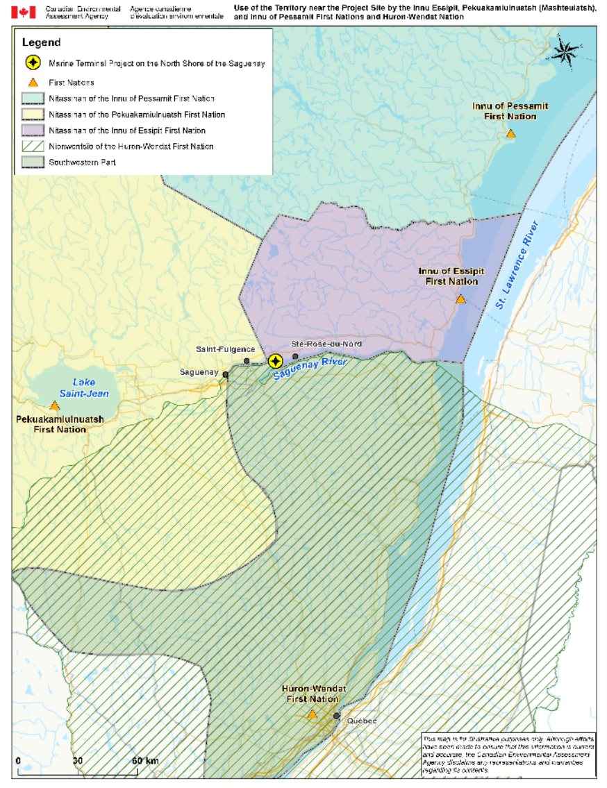
Source: Canadian Environmental Assessment Agency, taken from EPOG (2004) and the map of Nionwentsïo
Project site and the Nitassinan of the Innu First Nations
The study on Indigenous knowledge and use of resources by the Innu Essipit, Pekuakamiulnuatsh (Mashteuiatsh), and Innu of Pessamit First Nations submitted by the proponent (WSP/GCNN, mai 2016, annexe F, Transfert Environnement et Société) states that First Nations were present in the Saguenay River estuary as early 6,000 to 3,000 years ago. The study was corroborated by the Essipit Innu, Pekuakamiulnuatsh and Pessamit Innu First Nations. The shores of the Saguenay River and, in particular, those of Sainte-Marguerite Bay, were occupied by large Indigenous communities as early as 6,000 years ago. Later on, the Innu First Nations lived along the tributaries of the Saguenay River and, at one time, along the shores of the Saguenay Fjord.
The Innu travelled the Saguenay River, which is included in the expanded study area, to get to other rivers and portage routes that led them into the interior of the territory (WSP/GCNN, mai 2016, annexe F, Transfert Environnement et Société). The Innu's historical use and occupation of the extended study area are corroborated by more than 100 historical references describing the toponymy, portages, hunting grounds and occupation sites (Conseil de la Première Nation des Innus Essipit, novembre 2016).
According to the proponent, the Essipit Innu and their ancestors also used the forest for hunting and trapping land mammals, and the coastline for salt water fishing and hunting seals and migratory birds. The shores of the Saguenay provided a wealth of resources, including sea-run salmonids. Salmon were likely fished at the mouth of the four salmon rivers flowing into the Saguenay: the Rivière-à-Mars River, the Petit-Saguenay River, the St-Jean River and, on the north shore, the Sainte-Marguerite River (WSP/GCNN, mai 2016, annexe F, Transfert Environnement et Société).
The beaver reserve lots, for which the Innu First Nations hold exclusive fur trapping rights, are located more than 50 km northeast of the project site. Therefore, fur trapping does not take place in the extended study area (WSP/GCNN, mai 2016, annexe F, Transfert Environnement et Société).
Several Innu families continue to practise traditional hunting and fishing activities in Upper and Lower Saguenay areas. The territories to the north of the Saguenay are still frequented by members of the Essipit Innu First Nation (WSP/GCNN, mai 2016, annexe F, Transfert Environnement et Société).
According to the proponent, there are currently no traditional or economic activities taking place within the limited study area, because this area is privately owned land. Few Innu go to the site itself. The proponent points out that the Essipit Innu ice fish for food in two sectors of the Saguenay River (WSP/GCNN, mai 2016): Anse-à-Benjamin (La Baie) and Sainte-Rose-du-Nord. This is apparently the only activity practised in the local study area. Apparently, The Pekuakamiulnuatsh First Nation also practises winter fishing (in Mashteuiatsh). However, according to the proponent, no fishing huts have been seen near the projected wharf infrastructure. The known ice fishing sites used by the local population are located further up the Saguenay River at Anse à Pelletier and to the east of the Jalbert Islands (WSP/GCNN, mai 2016). Moreover, the immediate project site is rarely visited by ice fishers because of the craggy shores that limit access to the river (WSP/GCNN, décembre 2017).
Ice fishing is currently banned within the jurisdiction of the Saguenay Port Authority, except for the Saint-Fulgence sector, for which an agreement was reached between the municipality and the proponent. The project site is not located in this area. However, the proponent has applied to Transport Canada for permission to extend its jurisdiction up to the boundaries of the Saguenay–St. Lawrence Marine Park, which would include the terminal project sector. The ban on ice fishing could therefore apply to the project sector in the future, limiting access to ice fishers.
Project site and the Nionwentsïo of the Huron-Wendat Nation
The Huron-Wendat also used the Saguenay River for their traditional activities (Huron-Wendat Nation, novembre 2017). According to the Huron-Wendat Nation, their Iroquoian ancestors frequented the Saguenay Fjord and sites such as Pointe-aux-Alouettes located in the St. Lawrence River at the mouth of the Saguenay River, as corroborated by a number of archeological sites and artifacts.
According to the Huron-Wendat Nation, as early as the 17th century and even before, their ancestors would travel to the Saguenay to trade and maintain diplomatic relations, and they reached an agreement with the Algonquians establishing the Saguenay River as the northeast boundary of the Huron-Wendat's traditional territory (Huron-Wendat Nation, novembre 2017). The territory, known as Nionwentsïo, or "our magnificent territory," corresponds to the territory frequented by the Huron-Wendat at the time of the Huron-British Treaty of 1760.
The Huron-Wendat Nation told the Agency that many of its members use the territory surrounding the project site, as well as the entire Saguenay River (Nation huronne-wendat, novembre 2017). It also told the proponent that current traditional activities have been documented in the local and extended study areas, namely navigation and fishing (Nation huronne-wendat, avril 2018):
? Potential effects are anticipated because of the presence and movement of ships and the increase in marine traffic, particularly the risk of accidents and collisions and the inherent risk of spills. The impact is expected to be especially significant on fishing activities near the project site and on the Saguenay River, including near the mouth of the Saguenay River, during the operational phase of the project.
? The increase in marine traffic would also have an effect on the Huron-Wendat's navigation of the Saguenay River. These effects could also be felt by the beluga whales, which are part of the cultural and natural heritage of the Huron-Wendat Nation, as is the ecological integrity of the territory in general. As mentioned earlier, the effects on the natural and cultural heritage are examined in Section 7.9.
According to preliminary information submitted by the Huron-Wendat Nation to the proponent, some Nation members fish at the mouth of the Rivière-à-Mars River located in the baie des Ha! Ha! in the local study area. Another Nation member fishes at the mouth of the Saguenay River and navigates the river between the Sainte-Rose-du-Nord sector and Tadoussac. Along this 100-kilometre route, there are various stopover and camping sites on the shores of the Saguenay River (Nation huronne-wendat, avril 2018).
In the complementary environmental impact study submitted to the proponent by the Huron-Wendat Nation, it was confirmed that Huron-Wendat were resident in the Saguenay region, and that several members of the Huron-Wendat Nation exercised their customary activities (Nation huronne-wendat, juin 2018). Some members of the Nation exercise customary activities, including fishing, boating, and fishing, hunting for several species, including migratory birds in the local study area, in and near the wider study area.
7.8.2 Proponent's assessment of environmental effects
Anticipated effects
According to the proponent, the effects of the project on the current use of lands and resources for traditional purposes are potentially related to changes in access and use of the territory associated with the perception of a loss of resource quality and a reduction in the success of ice fishing practised by some First Nations members. The proponent is proposing several mitigation measures to protect the fish and fish habitat, as well as the practice of ice fishing. These measures are outlined in Appendix E.
The proponent points out that the Essipit Innu practise winter fishing for food in two sectors of the Saguenay River (WSP/GCNN, mai 2016): Anse-à-Benjamin (La Baie) and Sainte-Rose-du-Nord. This would be the only activity practised in the local study area. The Pekuakamiulnuatsh First Nation also practises ice fishing (in Mashteuiatsh). The proponent maintains that the project will have no residual adverse effect on the current use of lands and resources for traditional purposes, considering that ice fishing will not be affected by the project and that no other use was identified by the Innu Essipit, Pekuakamiulnuatsh (Mashteuiatsh), and Innu of Pessamit First Nations (WSP/GCNN, mai 2016).
In the absence of information about the uses made by the Huron-Wendat Nation, the proponent assumed that its members used the area in the same way as the Innu Nations and the general public. Potential sources of adverse effects on current Huron-Wendat use of lands and resources for traditional purposes examined by the proponent involved mainly the project's effects on the fishing practised by some Nation members (WSP/GCNN, janvier 2018). The proponent concluded that there were no significant effects on the Nation's current use of lands and resources for traditional purposes (WSP/GCNN, janvier 2018).
Change in access and use of the territory
The proponent does not anticipate any environmental effects on the current use of the territory by the Innu Essipit, Pekuakamiulnuatsh (Mashteuiatsh), and Innu of Pessamit First Nations, as well as the Huron-Wendat Nation as regards the limited study area during the various phases of the project, because they do not practise activities in the terrestrial environment and because the project would not have an effect on ice fishing (WSP/GCNN, mai 2016). According to the proponent, based on the work that would be done during the winter, the ice might occasionally have to be removed near the wharf, which could cause the ice to break up along a few dozen metres of the Saguenay River.
During the operational phase, icebreakers clearing access routes to the terminal for cargo ships would open up the ice over an area approximately 100 m long by 3,600 m wide, corresponding to the path the icebreaker would take to get to the wharf from the Saguenay River's navigation channel, for a total loss of about 36 hectares of ice. The total area of ice affected by the icebreaker's passage would be limited to the area around the icebreaker's path. Because of the icebreaker's small size and the marine terminal's location at a bend in the Saguenay River, the proponent maintains that the icebreaker's wake would not destabilize large portions of the ice floe. The amount of time that the ice is disturbed would vary, depending on the frequency of the icebreaker's trips, because it would accompany each ship requiring its services. The proponent states that, after the ice breaker's passage, the wake would freeze over again with the cold weather and the local movement of the ice. The icebreaker's passage would not affect known fishing sites, such as the one at Anse à Pelletier. However, the proponent said that ice fishing would no longer be possible in the immediate area of the maritime terminal (WSP/GCNN, mars 2017).
Any expansion of the proponent's maritime jurisdiction to include the terminal project sector (described in Chapter 2) would make the proponent responsible for managing ice fishing in the sector. The proponent has not determined how ice fishing might be managed in the new sector, but is considering three options to ensure the continuation of safe ice fishing (WSP/GCNN, mars 2017):
- Status quo: prohibit ice fishing everywhere except in designated areas authorized by the Saguenay Port Authority and reach agreements with the authorities responsible for managing the sites. This is currently the case in the Saint-Fulgence sector;
- Prohibit ice fishing everywhere except in designated areas and leave management of the authorized sites to the authorities currently in charge, which have an agreement with the Saguenay Port Authority;
- Authorize ice fishing everywhere, except for areas near the wharves and the navigation channel; authorize ice fishing sites and reach agreements with the authorities responsible for managing recognized sites.
Change in wildlife and plant resources
The proponent believes that the project would have no effect on the abundance of either freshwater or salt water fish supporting traditional fishing activities (see Section 7.3 for information on fish and fish habitats). The proponent also believes that there would be no impact on aquatic birds supporting waterfowl hunting, because very few waterfowl can be found in the project sector during migration periods, except for the marsh areas along the Saguenay River near Saint-Fulgence (WSP/GCNN, mai 2016).
Anticipated mitigation, monitoring and follow-up measures
Since it does not expect there to be environmental effects on access to the territory and the availability of resources, the proponent does not anticipate any mitigation, monitoring or follow-up measures related specifically to current use. However, it is proposing mitigation measures to protect fish and fish habitat (Section 7.3). It is also assessing management options that could make safe ice fishing possible in the future extended jurisdiction of the Saguenay Port Authority.
7.8.3 Opinions
Government authorities
Fisheries and Oceans Canada believes that the residual effects on fish and fish habitat can be mitigated or offset. In addition, Fisheries and Oceans Canada and Environment and Climate Change Canada feel that the monitoring and follow-up program for fish and water quality proposed by the proponent is realistic and adequate for the construction phase, and that long-term follow-up would be required to assess and monitor the effectiveness of the proposed mitigation measures.
According to Environment and Climate Change Canada, if the proponent implements all of the mitigation measures identified, they will help minimize the project's potential effects on migratory birds.
First Nations
Innu
The Essipit Innu First Nation said that they have no information as to whether the project site is used by its members for traditional purposes, either in the terrestrial environment or the aquatic environment where the wharf would be built (Conseil de la Première Nation des Innus Essipit, mai 2015). The two other Innu First Nations made similar comments. According to the Innu First Nations, this lack of use can largely be explained by the fact that the land is often privately owned, therfore allowing for limited use.However, the Innu nations have identified several concerns related to the project.
They mentioned the importance of setting up an offset program for rainbow smelt and asked that the offset measures include the restoration of habitats or spawning areas for the fish. These nations consider smelts the ideal prey for several other fish species and therefore an important link in the Saguenay ecosystem, with substantial economic and recreational tourism potential. They also requested measures to offset the loss of benthic fauna at the projected wharf site.
At a technical meeting with the proponent and the experts department (Agence, octobre 2016), the Innu Essipit, Pekuakamiulnuatsh (Mashteuiatsh), and Innu of Pessamit First Nations mentioned being concerned about habitat loss and the adverse effects of noise and light pollution, particularly on terrestrial wildlife and at-risk species such as Canada Warblers and bats.
The effect of dynamiting on terrestrial wildlife, fish and marine mammals is also an issue for the Innu Essipit, Pekuakamiulnuatsh (Mashteuiatsh), and Innu of Pessamit First Nations (Agence, octobre 2016).
The Innu Essipit, Pekuakamiulnuatsh (Mashteuiatsh), and Innu of Pessamit First Nations are concerned about the environmental effects of maritime transportation, which is why they believe that this aspect should be included in the environmental assessment for the project. They are mostly concerned about the risk of accidents (malfunctions, collisions, spills, etc.) related to the increase in marine traffic and the arrival of future clients at the terminal. In particular, the Essipit Innu Nation expressed its concerns about the potential effects of maritime transportation on Innu cultural practices (Innu Aitun), such as hunting migratory birds and marine mammals and fishing at the mouth of the Saguenay River and along the coastline up to Les Escoumins. These concerns will be addressed in Chapter 9 on the project's impact on the Innu Essipit, Pekuakamiulnuatsh (Mashteuiatsh), and Innu of Pessamit First Nations, as well as the Huron-Wendat Nation' rights.
The Innu Essipit, Pekuakamiulnuatsh (Mashteuiatsh), and Innu of Pessamit First Nations also raised concerns about the potential effects of maritime transportation on the commercial fishing of green sea urchins, shrimp and snow crab (in partnership with the Pessamit Innu), as well as on a number of recreational tourism activities, including whale-watching cruises and tourist accommodations along the coast. (Conseil de la Première Nation des Innus Essipit, 2015; Agence, octobre 2016, WSP/GCNN, mai 2016, annexe F, Transfert Environnement et Société). These socioeconomic aspects are addressed in Section 7.10. Marine transportation could also have an effect on future activities of the Pekuakamiulnuatsh, including commercial fishing at the mouth of the river. This aspect is addressed in the chapter on the impact of the project on the Innu Essipit, Pekuakamiulnuatsh (Mashteuiatsh), and Innu of Pessamit First Nations, as well as the Huron-Wendat Nation' ancestral rights (Chapter 9).
The Innu Essipit, Pekuakamiulnuatsh (Mashteuiatsh), and Innu of Pessamit First Nationsalso raised questions about the loss of a forest stand of phytosociological interest, i.e., a four-hectare white pine forest with red pine, black spruce and Eastern white cedar (Conseil de la Première Nation des Innus Essipit, November 2016). This aspect is addressed in Section 7.2 on wetlands and vegetation.
The Huron-Wendat
Like the Innu Essipit, Pekuakamiulnuatsh (Mashteuiatsh), and Innu of Pessamit First Nations, the Huron-Wendat Nation also raised similar concerns, believing that the project's construction phase and navigation during the operational phase could have an impact on their fishing and navigation activities.
Accidents and malfunctions, and especially the risk of spills and collisions due to increased navigation, particularly in the exploitation phase, are of concern to the Huron-Wendat Nation, because they could have a significant impact on their traditional contemporary activities. This is also the case for the navigational activities of the Huron-Wendat both in the local study area, in the wider study area, and in the vicinity of it. The effects of project-related accidents and malfunctions are addressed in Section 8.1. The effects of accidents and malfunctions due to increased navigation beyond the proponent's control, particularly at the mouth of the Saguenay River, are addressed in Section 8.4.
The Huron-Wendat Nation recommended monitoring the customary activities of the Huron-Wendat Nation, during the construction phase and the operation phase, in the wider study area and in close proximity to it, in particular navigation and fishing for various species, including Atlantic salmon and striped bass. This would allow for future information regarding the Huron-Wendat. The follow-up would also make it possible to consider unforeseen effects during the environmental assessment, as well as additional relevant measures, while promoting a direct communication link between the proponent and the Huron-Wendat present in the territory concerned throuth the Nionwentsïo Office of the Huron-Wendat Nation (Nation huronne-wendat, juin 2018).
Public
The public has not commented on the current use of lands and resources for traditional purposes.
7.8.4 Agency analysis and conclusions
Given the key mitigation measures indicated below, the Agency concludes that the project is not likely to cause significant adverse environmental effects on the current use of lands and resources for traditional purposes.
Current uses in the sector concerned reported by the Innu Essipit, Pekuakamiulnuatsh (Mashteuiatsh), and Innu of Pessamit First Nationsare limited to ice fishing by some of their members. The Huron-Wendat Nation mentioned summer fishing in the baie des Ha! Ha! and at the mouth of the river. The construction and operational phases of the project would result in little change in access to traditional territory and land use. The effects of navigation beyond the proponent's control are addressed in Section 8.4. The Agency believes that the project is not expected to have an impact on Indigenous fishing given the absence of a significant adverse effect on fish and fish habitat (Section 7.3).
In addition, the sector is not recognized as a significant fishing site for the First Nations consulted and the project would not adversely affect fish resources in the Saguenay River at any time of year. However, the Agency notes that the possible extension of the Saguenay Port Authority's jurisdiction could change the regulating of ice fishing in the sector.
The project site and the limited study area are not conducive to the presence of waterfowl. The project would therefore have no impact on this resource, its location or its abundance (Section 7.5).
The Agency has not received information from either the proponent or the First Nations consulted concerning the presence of plant species of interest for the current uses of the projected terminal site.
The Agency concludes that the project would have little effect, since it would cause little or no change in the current use of lands and traditional resources by the First Nations consulted (ice and summer fishing) and few or no changes in the abundance of these resources. Thus, the Agency considers that it is not necessary to recommend a follow-up program to monitor the customary activities of the Huron-Wendat Nation or the traditional activities of the Innu First Nations. However, the Agency recommends in the previous chapters a follow-up program (surface and ground water quality related to fish, birds and natural heritage) and compensation programs (fish habitat and wetlands) for which First Nations should be consulted.
However, the Agency is of the opinion that the project is only one of a series of activities on the Saguenay River and, based on the comments of the Innu Essipit, Pekuakamiulnuatsh (Mashteuiatsh), and Innu of Pessamit First Nations, as well as the Huron-Wendat Nation, it adds to the overall pressure on the nations' ability to exercise their rights and practise their traditional activities. The impacts on the rights of the First Nations consulted are addressed in Chapter 9. In addition, the Agency took into consideration the nations' concern with respect to the cumulative effects of the various maritime projects on the river, although this is beyond its environmental assessment mandate. Section 8.4 on the effects of navigation beyond the proponent's control briefly addresses these issues.
Proposed mitigation, monitoring and follow-up measures
The Agency believes that the following mitigation measures are necessary to ensure that there are no significant adverse environmental effects on the use of lands and resources for traditional purposes:
- Implement key mitigation measures for the protection of fish habitat set out in Section 7.3;
- Implement key mitigation measures concerning accidents and malfunctions under the proponent's responsibility set out in Section 8.1 in order to avoid adverse effects on resources;
- Develop, prior the operation and in consultation with the Innu Essipit, Pekuakamiulnuatsh (Mashteuiatsh), and Innu of Pessamit First Nations, as well as the Huron-Wendat Nation and potentially affected parties, an ice fishing management plan so that the activity can be practised safely in the area of Saguenay Port's jurisdiction established under the Canada Marine Act. Implement the management plan during the operational phase. The management plan will include how the views and information provided by the Innu Essipit, Pekuakamiulnuatsh (Mashteuiatsh), and Innu of Pessamit First Nations, as well as the Huron-Wendat Nation and potentially affected parties will be taken into account during the development of the management plan. Submit the management plan to the Agency before the operational phase;
- Provide the Innu Essipit, Pekuakamiulnuatsh (Mashteuiatsh), and Innu of Pessamit First Nations, as well as the Huron-Wendat Nation with the schedules and updates or revisions to the initial schedules at the same time that these documents are provided to the Agency.
The Agency finds that no follow-up program is necessary to verify the accuracy of the expected results on the current use of lands and resources for traditional purposes, since the project is expected to have little effect.
7.9 Physical and cultural heritage
The potential effects of the project on the physical and cultural heritage, specifically on the landscape, are among the concerns that have been raised by the public and the First Nations consulted. The Agency's view is that the physical and cultural heritage may include features such as the land or resources (eg: artifacts, objects or places), as well as structures, sites or items of significance, distinguished from the background by the value attributed to them (Agency, 2015). The geological formation of the Saguenay Fjord and archaeological relics, for example, both meet this definition.
For the purposes of the environmental assessment, the effects of the project on the physical or cultural heritage and on structures, sites and other items of historical, archaeological, paleontological or architectural significance must result from an alteration of the environment (changes to the plant cover, soil, water, fauna or habitat). The Agency's analysis takes account of the viewpoint of the First Nations consulted and of local people and covers the following elements:
- Material objects, structures or human activities (for example, traditional crafts, fossilized remains, historic buildings);
- Sites or places (for example, burial grounds, sacred sites, natural landscapes, cultural landscapes);
- Attributes (for example, languages, beliefs).
The Agency defines significant residual adverse effects on the physical or cultural heritage or on structures, sites or items of historical, archaeological, paleontological or architectural significance as those entailing loss or alteration of some of their inherent characteristics in a way that compromises their long-term integrity or blocks access to important sites. The criteria for evaluating environmental effects and the Agency's scheme for determining the scale of the effects are shown in Appendices A and B respectively.
On concluding its analysis, the Agency finds that, given the application of mitigation measures, the project would not be likely to entail serious adverse environmental effects on the physical and cultural heritage:
- The project location is outside the protected areas of the Saguenay Fjord, namely the Saguenay – St Lawrence Marine Park and the Fjord-du-Saguenay Park, and cannot be seen from either of these parks;
- The project would not compromise the long-term integrity of the physical heritage of the Saguenay Fjord, since the stretch of the fjord to which the project applies is already characterized by the existing infrastructure of the Grande-Anse marine terminal, and the proportion of the shoreline disturbed is trivial relative to the entire fjord.
- The project is unlikely to compromise the integrity of cultural heritage or structures, sites or items of historical, archaeological, paleontological or architectural significance.
The following sub-sections lay out the baseline conditions and essentials of the proponent's analysis. They also present the opinions of the competent government departments, the First Nations consulted and the public on which the Agency relied in reaching its conclusions on the seriousness of the effects of the environmental changes on the physical or cultural heritage and on structures, sites or items of historical, archaeological, paleontological or architectural significance.
7.9.1 Baseline conditions
This section spells out the baseline conditions of the physical and cultural heritage, based on the information provided by the proponent. It may also contain input received from the public, the First Nations consulted and governmental entities.
Physical heritage
The proponent has rated the effects on the physical heritage by examining the project's effects on the visual environment. He defines the visual environment as being composed of the actual landscape, representing a set of interacting natural and human ecosystems, the visible landscape, as perceived, and a symbolic landscape resulting from the values assigned to it by observers (Létourneau et al. 2013).
The Saguenay Corridor, through which the river and the fjord Footnote 33 run, links Lac Saint-Jean to the St Lawrence Estuary. The proponent states that the Saguenay Fjord stretches for 120 kilometres and offers breathtaking vistas, punctuated by headlands, sheer cliffs and almost vertical rock walls, generally inaccessible except by water (WSP/GCNN, mai 2016). The marine portion of the Saguenay fjord is part of the Saguenay – St Lawrence Marine Park (SSLMP), managed jointly by the governments of Canada and Quebec, with participation by shoreline communities. Certain portions of the land bordering the SSLMP fall within the limits of the Fjord-du-Saguenay National Park, managed by the Société des établissements de plein-air du Québec. Both parks are part of the physical heritage and are considered of great value in terms of science, conservation and natural beauty. The proposed project site lies upstream from the two parks.
A regional initiative to have the Saguenay Fjord recognized as a world heritage site by UNESCO (United Nations Educational, Scientific and Cultural Organization) was launched by several regional partners, including the Innu of Essipit First Nation. However, the site did not appear on the tentative list of world heritage sites in Canada in December 2017. Nonetheless, the information presented in the proponent's impact study shows that the Saguenay Fjord constitutes a major focal point for the First Nations and a unifying factor for developing the region's economy and tourism and recreational potential (WSP/GCNN, mai 2016).
The project would be located on the north shore of the Saguenay, in a section of the river known as the North Arm of the fjord, specifically part of the undeveloped wooded slope between Anse à Pelletier and Cap à l'Est. There are a few dwellings and buildings scattered here and there along Highway 172, which provides access to the planned terminal site. A few secondary roads give access to year-round and seasonal homes on the shores of the larger lakes in the vicinity of the project, among them Lake Neil and Lake Bouchard, and to Pointe aux Pins Bay, near the Jalbert Islands, and Anse à Pelletier (Figure 14). At Cap Jaseux, west of the project site, Parc Aventures Cap Jaseux hosts nearly 20,000 visitors a year and offers recreational and tourist activities such as hikes along the shores of the fjord and a launch ramp for kayaks.

Source: WSP/GCNN, May 2016
On the south shore of the Saguenay, the Cap-à-l'Ouest peninsula opposite the project site is forested except for the port facilities of Grande-Anse, administered by the proponent, and formerly cultivated enclaves. The land is mostly given over to agroforestry, except for the slopes along the fjord, which are wooded and mainly used for recreation and tourism.
The proponent reports that apart from the use of recreational and tourist sites by riparian residents and users, enterprises offer boating excursions and cruises on the North Arm. Observers enjoy long and open views of the shores and of the wooded summits of the surrounding hills, including those where the project will be.
Cultural heritage and historical and archaeological sites
Historically, the Saguenay Fjord served as an access route to the riches of the hinterland and as a trade and communication axis. Today, in the environs of the project, the population is concentrated mainly within the urban limits of the borough of Chicoutimi (Canton-Tremblay) and Saint-Fulgence on the north shore of the river and in the boroughs of Chicoutimi and La Baie on the south shore (Figure 14).
The proponent reports that there was a Euro-Canadian presence in the local study area long before the Saguenay region was opened up to logging in 1938. When the Chicoutimi trading post was established in 1676, it was already known to be part of an active hunting territory. Anse à Pelletier was a prized and busy hub for trading in pelts (furs). Historical data also refer to the use of the territory east of Anse à Pelletier, in particular logging camps around Lake Neil, and occupancy of site known as "Le Petit Glaude", probably comprising a family home and a sugar shack.
The proponent reports that the historical use of the territory and its resources, documented by the Innu along the Saguenay River, confirms the human presence along the Saguenay River. In fact, the study on Indigenous knowledge and the use of resources and territory as part of the Saguenay North Shore terminal project (WSP/GCNN, mai 2016, annexe F, Transfert Environnement et Société) demonstrates that toponymy, ethnohistory, portages and ways and sites of occupation and hunting how much the Saguenay is part of the cultural heritage of the Innu. However, no known occupation site has been flagged in the limited study area following consultation of the various sources of information (resource persons and literature), including the study of archaeological potential conducted in the area targeted by the project and filed by the proponent with the impact study (Subarctique, 2014). Though a few archaeological sites have been identified in this study at the mouths of the main tributaries of the Saguenay River, the potential of the hinterland in this region is poorly documented.
According to data from archival maps from the 18th century, there were two portages of interest to the Innu Essipit, Pekuakamiulnuatsh (Mashteuiatsh), and Innu of Pessamit First Nations NationPessamit (Conseil de la Première Nation des Innus Essipit, 2016) located in the project area. Both routes cross the local study area, but without penetrating the limited study area. One ran from the mouth of the Pelletier River to Little Lake Saint-Germain, and the other from the small bay between Anse à Pelletier and Cap à l'Est to the Sainte Marguerite River. The Huron-Wendat Nation, too, have told the proponent that the Saguenay River was frequented by their ancestors both in transit and for the practice of traditional pursuits. Accordingly, the Huron-Wendats have erected a number of camps on the shores of this river at places where archaeological evidence of the presence of their ancestors has been found. According to the Huron-Wendat, the project site may harbour archaeological artifacts linked to their nation (Nationhuronne-wendat, 2017).
The archaeological potential study, carried out by Subarctique (2014) on the basis of mapping and documentation (without a site inventory or survey), identifies two areas of low archaeological potential on the project site (Figure 15). These areas are likely to harbour traces of prehistoric or early historic occupations.
Sector 6, with an estimated area of 63,556 square metres, is located near the dock access road, but will not be affected by the work (Figure 15). Sector 7, with an estimated area of 10,974 square metres, is located near the shore of the Saguenay River and crossed by the access road to the dock. The Subarctique study (2014) specifies, though, that sectors potentially containing more recent relics, dating from the periods of colonization and logging, have not been considered.
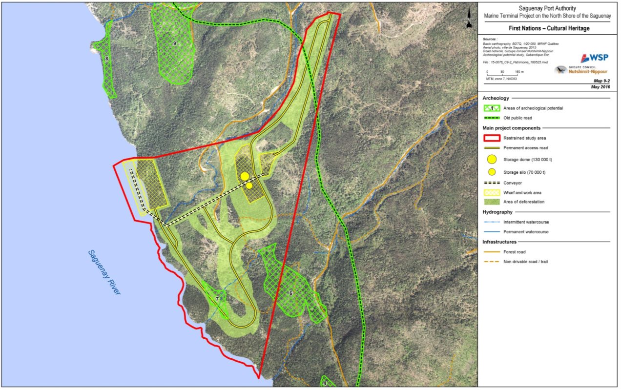
Source: WSP/GCNN, May 2016
7.9.2 Proponent's assessment of the effects
Anticipated effects – Physical heritage
According to the proponent, the adverse effects of the project on the visual environment would result chiefly from the exposure of a rock wall 65 metres high and 280 metres wide and the erection of industrial structures (silos, shed, quay, conveyor, etc). The scale of the effect would be variable, depending on how the changes would appear to an observer, defined by what the observer can see, what value he attaches to the view and the distance of the potential points of observation. Observers located in landscape units R2, R3 and R4 along the Saguenay River (Figure 14) would be most affected by the project. The other landscape units assessed, including sectors of the Saguenay – St Lawrence Marine Park and the Fjord-du-Saguenay National Park, are out of sight of the project site.
In the construction phase, the proponent concludes that the adverse effects would be minor on all the landscape units assessed, with two exceptions, where major adverse effects are foreseen. The proponent's assessment indicates that the intensity of the effects will be strong and will be of average duration (over a year), and the effects would be irreversible for the landscape unit on the north arm of the Saguenay, which includes the project site (unit R2) and the one at the confluence with the downstream part of the fjord facing the project (unit R3).
In the operating phase, the proponent rates the residual effect as insignificant for all landscape units, given the mitigation measures being proposed, such as replanting of areas disturbed by the work and use of camouflaging paint on infrastructure. He nonetheless acknowledges that locally in unit R2, the residual effect will be significant for users of this stretch of the fjord (kayakers, boaters, cruise passengers, etc) and for some residents of Anse à Pelletier (west of the project) and Anse au Sable (opposite the project). This is explained by the fact that the growth of vegetation will do little to reduce the visibility of the installations, especially the exposed rock wall behind the dock as seen by these observers (Figure 16). The proponent bases this conclusion on the great environmental value attached to this landscape by these observers and on the irreversible character of the effect.
Methodology
To assess the effects on the landscape ("visual" component in the impact study, WSP/GCNN, mai 2016), the proponent defined a landscape study area subdivided into 16 distinct landscape units, representing 5 types of landscape: riverine, urban, agricultural, hilly and lacustrine. He then rated the degree of landscape disturbance in terms of the visibility of the changes wrought and the planned new structures and infrastructure, as seen by an observer located in each landscape unit. The degree of visibility can be seen as the level of visual influence of the infrastructure on an observer as shown in Figure 14. The level of visual influence is not uniform among landscape units, since it depends on where an observer stands. The proponent considered the following influence levels, established on the basis of the distance between an observer and the project, to illustrate the significance of the visual perception of the infrastructure:
- Area of strong influence: covers a radius of about ten times the overall height of the infrastructure, amounting to a radius of 645 metres given the height of the exposed rock wall;
- Area of moderate influence: covers a radius of about 100 times the overall height of the infrastructure, amounting to a radius of 6.45 kilometres;
- Area of low influence: covers the sectors within which the infrastructure remains visible, the limit being set at 25 kilometres.
According to the proponent, in the construction phase the project would change the visual environment and aesthetic quality of the portion of the fjord targeted by the work because of clearcutting and land preparation to expose the rock face (soil stripping, dynamiting of the cliff). Construction of access roads, industrial infrastructure (silo, dome, shed, transfer tower, conveyors) and the dock (wharf, traffic area, ship loader) would also entail changes to the visual environment. Construction of the terminal would add new industrial infrastructure to a portion of the shoreline of the fjord hitherto little disturbed by human activity.
Within landscape unit R2, the visual influence of the infrastructure would be non-existent for residents at the mouth of the Pelletier River and in the curve of Anse aux Sable. The visual influence of the infrastructure would still be strong for residents of Anse à Pelletier, who have long and open views on the fjord, and owners of holiday homes at the western end of Anse au Sable.
Pleasure boaters, cruise passengers, sea kayakers and other occasional users of landscape units R2 and R3 would also see their visual environment altered during construction of the terminal. The visual influence of the infrastructure is considered non-existent for the location of the Cap au Lest outfitters, the Cap à l'Est lighthouse, the New France site, the Saguenay – St Lawrence Marine Park and the Fjord-du-Saguenay National Park, since these sites are out of sight of the project location.
During the operational phase, activities that would have effects on the visual environment and the aesthetic quality of the landscape are essentially associated with the physical presence of various installations at the marine terminal and on the land and shoreline, likewise the occasional berthing of a ship at the dock. The arrival of new clients, increasing the amount of infrastructure, may have some effects on the landscape. According to the maximum operation scenario submitted by the proponent (see chapter 2), additional storage infrastructure (silo or shed) north of the silo and dome planned for stockpiling apatite (on cleared land) and a conveyor for moving material to the dock conveyor would need to be built. This infrastructure would be visible from shoreline properties, public places and tourist sites with a direct view of the project site, as well as from the water, for observers on pleasure craft or cruise ships plying the Saguenay in landscape units R2, R3 and R4 (Figure 14). According to the proponent, the visual influence of this infrastructure would be strong for residents of Anse à Pelletier and the home on Anse au Sable, since the top of the silo and dome for storing apatite or other storage structures for future clients, the exposed rock face along the shore and the dock would remain visible, even allowing for the mitigation measures.
For the decommissioning phase, the proponent plans to remove only the infrastructure associated with the terminal's clients (silo, shed, conveyor). Multi-purpose installations (access road, dock, traffic area and ship loader) will not be dismantled. Removal of the large client-related industrial infrastructure and restoration work, including site replanting and reforesting, at the end of work will help attenuate the terminal's visual footprint.
In response to the concerns raised by the public and the First Nations consulted to the effect that the marine terminal project on the north shore could hinder efforts to register the Saguenay Fjord as a UNESCO World Heritage Site, the proponent says that river landscape R2, targeted for the terminal, is already characterized by the presence of port infrastructure at the Grande-Anse marine terminal on the south shore. These conditions mean that the stretch of the fjord targeted by the project already falls short of UNESCO's guidelines set out in the World Heritage Convention for selecting sites, but that the terminal's presence should entail no environmental effect on those portions of the fjord that do meet UNESCO's criteria.
Mitigation measures and follow-up proposed by the proponent
In order to reduce the adverse effects on the landscape and the perceived visual environment, the proponent undertakes to implement the following mitigation measures:
- Paint site structures and the marine terminal (silo, dome, service buildings, conveyors, etc) in neutral colours with a mat finish to blend in with the colours of the surrounding natural environment and reduce their reflectance;
- Promptly replant the scree and denuded surfaces as the work proceeds. Provide for diversified planting comprising a mix of indigenous hardwood and softwood species typical of the surrounding area. In order to expedite plant growth, plant stands of mixed sizes;
- At the foot of each dynamited rock face, dig drainage trenches so that a screen of trees can be planted. Replant the base of the exposed rock surfaces with hardwoods (balsam poplar) and softwoods (cedar), arranged alternately and spaced 5.5 metres centre to centre. The saplings would be about 150 centimetres tall on planting. Plant as promptly as possible after completion of work on roads and assorted adjoining areas;
- At the crest of each dynamited rock face visible from the water, plant rustic climbing vines, regularly spaced 3 metres apart centre to centre, so as to cloak the exposed rock surfaces in greenery.
Simulations run by the proponent make it possible to visualize the effects of the project and the mitigation measures, as they would be seen by different observers located in the project's areas of visual influence, especially by the residents of Anse à Pelletier (Figure 16) and by observers on a cruise ship heading for La Baie (Figure 17). These visual simulations were carried out considering only the known infrastructure of the primary client, Arianne Phosphate. Future installations (shed, conveyor) which may be required for new clients would be built on surfaces already disturbed by the work. The proponent estimates that the mitigation measures will achieve their optimum visual efficacy after some 20 years, given the height reached by the tree stands and their effectiveness in integrating the installations visually into the surroundings and in reducing their visibility to various observers with a view of the site.
The proponent further undertakes to monitor the integration of the work into the visual environment of the Saguenay Fjord, including rigorous maintenance of the infrastructure and an annual inspection (WSP/GCNN, mars 2017). Photographs taken five years after the end of the work will be used to compare the actual visual effects on the landscape with expectations derived from the simulations and validate the efficacy of the mitigation measures applied. Remedial measures would be enacted as needed. Photographs would then be taken every two years from the same points to track how the vegetation evolves. A monitoring committee (local relations committee) would also be set up to provide contact with the public and oversee the upkeep of the visual environment mitigation measures (WSP/GCNN, mars 2017).
With regard to the arrival of new clients, the proponent states that all applicable regulatory processes will be applied to ensure that the environmental effects associated with a new client's project are assessed and appropriate mitigation measures are taken, in particular for the physical heritage. The proponent, being a federal authority, has obligations in that regard under section 67 of the Canadian Environmental Assessment Act, 2012.
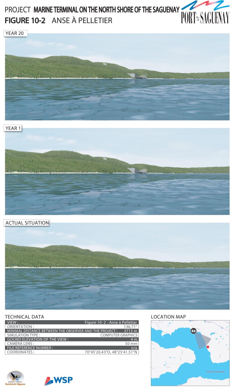
Source: WSP/GCNN, May 2016

Source: WSP/GCNN, May 2016
Anticipated effects – Cultural heritage, historical and archaeological sites and structures
According to the proponent, the adverse effects of the project on cultural heritage are related to site preparation activities and the construction of a culvert to cross the watercourse and of an access road to the dock and its peripheral slopes (WSP/GCNN, mai 2016). This work involves excavation or backfill that can result in soil or sediment disruption or the injection of additional backfill. This could cause accidental breakage of objects, displacement of artifacts, exposure of archaeological relics or, conversely, the addition of backfill materials that may limit access to relics related to the First Nations or to the Euro-Canadian presence.
The proponent considers that the work would disrupt the quality and integrity of this element only slightly, since no high-potential site has been identified. Moreover, the mitigation measures would allow for the identification, retrieval and preservation of the cultural heritage, or of things of archaeological significance in the event of a discovery during the work. The effects would be irreversible, but localized and deemed unlikely in view of the mitigation measures. The proponent indicated that the design of the road could not be optimized so as to avoid the sectors identified as having archaeological potential because of technical criteria related to the area's rugged terrain. The proponent agrees to include the Innu Essipit, Pekuakamiulnuatsh (Mashteuiatsh), and Innu of Pessamit First Nations, as well as the Huron-Wendat Nation workforce in possible archaeological digs on identified potential sites and elsewhere on the project site, in the event of an archaeological discovery.
The proponent specified that during the operating and dismantling phase, no activity is likely to disrupt the cultural heritage, since no other excavation work will take place and the access road to the dock will remain in place.
Mitigation and follow-up measures proposed by the proponent
To reduce the adverse effects on the cultural heritage, the proponent agrees to implement the following mitigation measure during the construction phase:
- Conduct an archaeological inventory prior to carrying out the tree-clearing and site preparation work within the area with archaeological potential where the work is to take place. If the presence of archaeological relics is confirmed, organize an archaeological dig in the sector under threat of destruction.
- If, during the work, relics of historical or archaeological interest are discovered, immediately inform the site supervisor and make arrangements to protect the site. Under the Cultural Heritage Act, it is prohibited to remove anything whatsoever and to displace objects and relics. Suspend the work in the area until the Minister of Culture and Communications authorizes resumption of the work.
The proponent agrees to conduct archaeological monitoring during the work in the areas of low archaeological potential affected by these activities in order to implement the above-mentioned mitigation measures. The proponent concludes that no follow-up program is required.
7.9.3 Observations received
Government authorities
Physical heritage
Parks Canada considers that the methodology used by the proponent is consistent with existing best practices for conducting impact studies on the visual environment. The concepts and the nature of the data collected have been tailored to the receiving environment and project issues. Moreover, Parks Canada considers that the spatial limits and reference data used by the proponent are sufficient and fair for assessing the effects on the landscape. With regard to the proposed mitigation measures, Parks Canada points out that high exposure to wind, unfavourable weather conditions and freezing of plants added to the base and crest of the rock walls would have an impact on the regrowth and sustainability of plant life (balsam poplar, cedars and vines) and that the actual visual effect of these plants is overestimated in visual simulations. It was suggested that the proponent assess the possibility of planting over a broader area (about 30 metres) and consider a larger variety of plants to ensure successful planting. The proponent pointed out that the size of the handling area behind the dock is viewed as minimal for preserving the multi-purpose character of the terminal. In this context, the proponent deems that it is impossible to develop a 30-meter band of vegetation, as this would require moving the wall back about another 25 metres, resulting in an increase in the height of the wall of almost 10 metres and the dynamiting of an additional volume of approximately 500,000 cubic metres of rock. As for plant species, the proponent argues that the balsam poplar and conifers, such as cedar, promote healthy growth under difficult conditions. The proponent would monitor the plants and apply any needed corrective measures, such as, for example, seeding new identified problem areas, replacing dead trees with other species (white pine, red pine, black spruce) or planting more trees in certain areas. Other corrective measures would also be implemented, as needed, such as repainting structures and adjusting the lighting (WSP/GCNN, mars 2017).
Since the proposed mitigation measures do not focus directly on the main visual nuisance, namely, the rock wall resulting from the excavation of the work area behind the dock, the Quebec department of sustainable development, environment and the fight against climate change and Parks Canada have suggested that alternatives to terracing-style (shelf- or step-style) excavation patterns be assessed. The proponent agrees that the effects on the proposed vertical excavation visual cannot be minimized any further. He however explained that terracing-style was excluded from the possible options because of technical problems related to the geology of the site and to safety. A block of stone detaching from the crest of a wall would be propelled much further away (springboard effect) with a terracing-style design than if the wall was excavated vertically, as chosen by the proponent. In addition, shelf-style cutting would lead to greater encroachment inland and major additional removal of landfill that would need to be relocated on the site, thereby having a greater impact on the landscape. The proponent also considers that the regrowth of plants on the shelves is uncertain owing the thinness of the soil and of the ice (WSP/GCNN, décembre 2017).
As mentioned previously, the Saguenay Fjord was not chosen as a site to be added to Canada's Tentative List of World Heritage Sites. Parks Canada confirmed the proponent's interpretation to the effect that the Saguenay Fjord site does not meet the World Heritage's high standard of outstanding universal value with respect to the value of its geological heritage or the value of its cultural heritage. However, the site has the potential of demonstrating outstanding universal value with respect to its biological productivity. Consequently, Parks Canada is of the opinion that the presence of the Marine Terminal on the North Shore is not likely to generate any probable environmental effects on efforts to register the Saguenay Fjord as a UNESCO (United Nations Educational, Scientific and Cultural Organization) World Heritage site as long as it has no impact on the Saguenay's biological productivity.
The ministère du Développement durable, de l'Environnement et de la Lutte contre les changements climatique considers negligible the measures proposed by the proponent to reduce the effects of the project on the landscape on the north shore of the Saguenay. The ministère du Développement durable, de l'Environnement et de la Lutte contre les changements climatiques is of the opinion that the effects of the project with the proposed multi-user design would contribute to maximizing an already significant change in the landscape that would be caused by the installation of a terminal aimed at a single user, thus creating an irreversible scar in the event of the cessation of port activities. For this reason, the ministère du Développement durable, de l'Environnement et de la Lutte contre les changements climatiques favors a marine terminal for the use of a single client. This choice would reduce the height of the rock wall at the back of the wharf and its overall footprint.
First Nations
Physical heritage
The Pekuakamiulnuatsh and the Innu of Essipit First Nations are involved with other partners in designating the Saguenay Fjord as a UNESCO World Heritage site. The Fjord is an important element of the cultural heritage of these First Nations. The Innu of Essipit First Nation is also very sensitive to the maintenance of the integrity of the Saguenay–St. Lawrence Marine Park.
The Huron-Wendat Nation emphasized that the Saguenay Fjord is a site of national interest to them. They raised concerns about the potential effects of increased navigation on the Beluga whale, which is part of the Huron-Wendat Nation's cultural and natural heritage, as well as the ecological integrity of the territory more generally. The effects of the project on the beluga are discussed in sections 7.4 (marine mammals) and 8.3 (cumulative effects).
Cultural heritage, historical and archaeological sites and structures
Even before the proponent's environmental impact study was tabled, the Innu Essipit, Pekuakamiulnuatsh (Mashteuiatsh), and Innu of Pessamit First Nationsinformed the Agency of their willingness to collaborate and take part in possible archaeological work that may be required to complete construction of the terminal. They also provided clarifications to correct the information presented by the proponent in his environmental impact study on the historical use of the land and its resources, including the following elements:
- The shores of the Saguenay feature sites that accommodated large groups (6,000) of Indigenous Peoples prior to the present, particularly in Baie Sainte-Marguerite;
- Both archaeological and documentary research indicate that some sections of the Saguenay shores were conducive to resource development, particularly anadromous salmonids Footnote 34. Salmon fishing was likely practiced at the mouth of the four salmon rivers flowing into the Saguenay;
- Many ancient portages linking the Saguenay to the hinterlands cross through the extended study area, as defined by the promoter in the environmental impact study. Two of these ancient portages cross the local area under study and link it to the Sainte-Marguerite River, without however crossing the restricted area under study;
- The Innu's use and historical occupancy of the extended study area, as defined by the proponent in the environmental impact study, covers over 100 historical references, both in terms of toponymy and portages, hunting grounds and occupancy sites.
The Huron-Wendat Nation is concerned about the potential effects of the project on their archaeological heritage and considers that they should have been consulted by the proponent prior to the assessment process (Nation huronne-wendat, 2017). Thus, the Nation could have contributed to the impact study along with other relevant information concerning the Huron-Wendat, both prehistorically and historically. The impact study omits to mention the previous presence of the Huron-Wendat Nation, which is unacceptable for this Nation (Nation huronne-wendat, 23 avril 2018). In addition, the Huron-Wendat Nation insists on the importance of its involvement in archaeological work related to the project. The Nionwentsïo Bureau reiterates that it must be closely involved, as soon as possible in these steps, including the choice of the archeology firm that will carry out the interventions. Assistants of Huron-Wendat archaeological excavations should also be present during the work to be done in the field.
The Public
Physical heritage
A number of citizens and environmental groups have voiced their concerns about the development of an industrial marine terminal in an undeveloped sector of the Saguenay Fjord, which is viewed as an element of great value for the region's physical heritage (CREDD, 2016; Collectif de l'Anse à Pelletier, 2016; Blackburn, 2016; Lord, 2016). Several of the region's players have supported the project to include the Saguenay Fjord on the UNESCO World Heritage List. Some citizens pointed out that the Anse à Pelletier landscapes are recognized for their natural beauty and actually show very little evidence of human activity. They refer to the comments of historian Russel-Aurore Bouchard, who describes this area as the "green diamond" of the Saguenay (Collectif de l'Anse à Pelletier, 2016).
According to a survey conducted by the Conseil régional de l'environnement et du développement durable du Saguenay – Lac-Saint-Jean (CREDD) (Saguenay–Lac-Saint-Jean regional council on the environment and sustainable development), altering landscapes ranks second in concerns related to the project's environmental effects, just behind the effects on water quality (CREDD, 2016). The CREDD pointed out that the proponent only takes into consideration docked ships into his assessment of visual effects and fails to consider sailing ships, which also have a visual impact.
Some citizens (Lord, 2016; Collectif de l'Anse à Pelletier, 2016) believe that this marine terminal, particularly the exposed rock wall of the cliff, would have a significant and irreversible effect on the landscape and that no mitigation measures could negate these effects. They mentioned that the construction of a port at this long pristine rock face would break the unity of the landscape. Some citizens have asked that an alternate shelf (or step) excavation method, on which trees would grow and fit more naturally into the landscape, be assessed.
Conversely, some people fear that step-style (terracing-style) excavation would have a greater visual effect (Collectif de l'Anse à Pelletier, 2016). The proponent's answers regarding this alternative are discussed in the previous section on Observations received from government authorities. Concerns were also raised about the effectiveness of the infrastructure maintenance measures, particularly to avoid the deterioration of the condition of the paint and the actual effectiveness of the planting of vines to mitigate the visual effect of the rock wall. Moreover, some citizens deplored the fact that visual simulations, carried out for year 1 and year 20 of the project, present only one user. They fear that the expansion of the storage areas as a result of the arrival of other clients will further alter the landscape. Other citizens also questioned the method used by the proponent to assess the effects on the landscape, as well as the use of the synthesized images to simulate the effects rather than using actual photographs.
Some observations received referred to the fact that the effect on the landscape of a project of this scale, suggesting permanent alteration of the landscape, should not be limited to what can currently be seen from areas occupied or used by human beings. The effect should also take into consideration the very nature of the landscape that is affected, how human beings might use it in the future, and its value. The rarity of the geological formation of the Fjord has also been underscored. Fjords at this latitude and of this length are extremely rare (Lord, 2016). Some citizens referred to the world's recognition of the beauty of the Saguenay Fjord landscapes. It was also mentioned that the project site will offer vistas that will be visible not only from dwellings, but also from the Anse à Pelletier beach and the Saguenay River.
Cultural heritage, historical and archaeological sites and structures
The public has not expressed any specific concerns about the cultural heritage.
7.9.4 The Agency's analysis and conclusion
Analysis of effects
Given application of the mitigation measures indicated below, the Agency considers that the project is unlikely to generate significant adverse environmental effects on the physical and cultural heritage. In the long term, the project would not compromise the integrity of the physical heritage of the Saguenay Fjord for the entire landscape units that have been assessed. The adverse effects on a structure, a site or a thing of historical, archaeological, paleontological or architectural importance are deemed non-significant (Annex C).
Physical heritage
The project would create a permanent, localized alteration of the landscape as a result of an exposed rock wall of 65 metres high and 280 metres wide, and the development of an industrial infrastructure on a natural and relatively undeveloped shore of the Saguenay Fjord. However, the Agency noted that the section of the fjord where the project will enfold is already characterized by the existing infrastructure of the Grande-Anse Marine Terminal, which is located on the Saguenay River, and that the proportion of the disrupted shore (280 metres) is of smaller scale in comparison with the fjord as a whole which is 105 kilometres long. The Saguenay Fjord is an environment that is highly valued by the First Nations consulted and the people living in the region. The downstream portion of the fjord is protected and enhanced within the limits of the Saguenay– Saint-Laurent Marine Park (aquatic environment) and the Saguenay Fjord Park (terrestrial environment). The project site lies upstream from these protected areas. The visual influence of this infrastructure on these sectors would be non-existent, since users cannot possibly see the project site from anywhere in the two parks. The Agency therefore considers that the effects of the project on the landscape would not, in the long term, compromise the integrity of the physical heritage of the Saguenay Fjord. However, in spite the mitigation measures proposed by the proponent to reduce the project's effects on the landscape, they do not allow for complete mitigation of the visual effects for observers located in landscape units R2 and R3, more particularly for residents of Anse à Pelletier, Anse au Sable and users sailing on the Saguenay River in the project area during the development phase.
The Agency has reviewed the impact on the landscape that could be caused by the infrastructure planned for storing apatite and that which may be required for future users (additional shed or silo), as estimated by the proponent in his maximum operations scenario. However, given that this scenario is hypothetical and the actual visual impacts that could be related to the facilities or to the operations of future users could differ significantly from what has been estimated, the Agency concludes that the following general mitigation measures should be implemented:
- The proponent shall consult the Innu Essipit, Pekuakamiulnuatsh (Mashteuiatsh), and Innu of Pessamit First Nations, as well as the Huron-Wendat Nation and other potentially affected parties prior to undertaking any major change to the project that is deemed likely to create adverse environmental effects, when, for example, a new user becomes a user of the designated project, and the proponent shall advise the Agency in writing, within 60 days of initiating any project change;
- When informing the Agency of any project change, the proponent shall provide the Agency with a description of the potential adverse environmental effects created by these project changes, the mitigation measures and the follow-up requirements to be implemented by the proponent, as well as the findings of the consultation with the Innu Essipit, Pekuakamiulnuatsh (Mashteuiatsh), and Innu of Pessamit First Nations, as well as the Huron-Wendat Nation and potentially affected parties.
Cultural heritage, historical and archaeological sites and structures
The site preparation activities and the construction of a culvert and an access road to the dock could result in accidental breakage of objects, displacement of artifacts, or exposure of archaeological relics. Conversely, these activities could lead to the addition of landfill materials that may limit access to the relics related to the First Nations or to the Euro-Canadian presence. The risks would be compensated for by the low archaeological potential of the sites affected by the work and the mitigation measures proposed by the proponent.
The Agency concludes that possible work to allow for the arrival of new clients could create impacts on the cultural heritage. This risk seems, however, mitigated by the fact that the sites targeted for the development of new structures for other clients, that is, the work area at the crest of the cliff where the silos and the storage shed (Figure 17) are located, do not involve any area of archaeological potential.
Key mitigation measures to avoid significant effects
The Agency has determined the necessary key mitigation measures so that the completion of the project does not create significant adverse environmental effects on the physical and cultural heritage. It has taken into consideration the mitigation measures proposed by the proponent, the opinions of government authorities, and the observations received from the First Nations consulted and the public. These measures are as follows:
- Paint the structures of the project, including the silo and dome, hangar, service buildings and conveyor, in colours that harmonize with the natural environment in the areas adjacent to the project, using a low-reflectance matte paint;
- Revegetate, in a uniform manner the constructed slopes, stripped surfaces, riparian strips and the base of the blasted rock faces as construction on themis completed so that there is a composition and abundance of vegetation comparable to that of the areas adjacent to the project. Use native deciduous and coniferous species;
- Revegetate, in a uniformmanner, the entire top of blasted rock faces that are visible from the Saguenay River with species of hardy falling vines;
- Have a qualified individual conduct, prior to the start of tree clearing and in consultation with the Innu Essipit, Pekuakamiulnuatsh (Mashteuiatsh), and Innu of Pessamit First Nations, as well as the Huron-Wendat Nation, an archeological inventory of archaeological potential area No. 7. In doing so, the proponent will:
- Discuss, before the start of the inventory, with each First Nation the possibilities of participation of each of the First Nations in carrying out the inventory, including the analysis of the results
- Consult with First Nations on the results of the inventory in accordance with the consultation requirements set out in condition 2.2 before publishing the inventory results;
- For any previously unidentified structures, sites or things of historical, archaeological, paleontological or architectural significance discovered within the project area during the archaeological inventory or brought to the Promotor by the Innu Essipit, Pekuakamiulnuatsh (Mashteuiatsh), and Innu of Pessamit First Nations, as well as the Huron-Wendat Nation or another party duringany phase of the project:
- Immediately halt work at the location of the discovery;
- Delineate an area of with a radius of at least 30 meters around the discovery as a no-work zone. The no-work requirement shall not apply to action(s) required to be undertaken to protect the integrity of the discovery;
- Have a qualified individual as it pertains to the recording, transferring and safekeeping of structures, sites or things of historical, archaeological, paleontological or architectural significance conduct an assessment at the location of the disovery;
- Inform the Agency and the Innu Essipit, Pekuakamiulnuatsh (Mashteuiatsh), and Innu of Pessamit First Nations, as well as the Huron-Wendat Nation within 24 hours of the discovery, and allow First Nations to monitor archaeological works;
- In consultation with the Innu Essipit, Pekuakamiulnuatsh (Mashteuiatsh), and Innu of Pessamit First Nations, as well as the Huron-Wendat Nation and relevant authorities, comply with all applicable legislative or legal requirements and associated regulations and protocols respecting the discovery, recording, transferring and safekeeping of previously unidentified structures, sites or things of historical, archaeological, paleontological or architectural significance.
Need for follow-up and follow-up requirements
Uncertainties have been raised regarding the effectiveness of mitigation measures involving planting at the base and at the crest of the rock wall, as well as those related to the painting of infrastructure. To verify the predictions of effects on the physical heritage as well as the effectiveness of the planned mitigation measures, the proponent shall develop and implement a program to follow up the integration of the work into the visual environment of the Saguenay Fjord, including:
- Prior to construction and in consultation with the Innu Essipit, Pekuakamiulnuatsh (Mashteuiatsh), and Innu of Pessamit First Nations, as well as the Huron-Wendat Nation, relevant authorities and potentially affected parties, develop a follow-up program to verify the accuracy of the environmental assessment and determine the effectiveness of the mitigation measures related to the adverse environmental effects of changes to the environment caused by the project on the natural heritage of the Saguenayriver. Implement the follow-up program during construction and operation;
- As part of the implementation of the follow-up program:
- Monitor the integrity of the covering material, including the paint of the project structures ;
- Monitor the growth, composition and abundance of the vegetation;
- Monitor the residual environmental effects of the project on the natural heritage using photographs taken from the same viewpoints as those used in visual simulations carried out for the environmental assessment. Take the photographs every two years during the first ten years after the end of the construction phase, and every five years thereafter, up to 25 years after the end of the construction;
- Share the results of the follow-up program with the Innu Essipit, Pekuakamiulnuatsh (Mashteuiatsh), and Innu of Pessamit First Nations, as well as the Huron-Wendat Nation, relevant authorities and potentially affected parties and consult them to develop and implement modified or additional mitigation measures.
No follow-up program for cultural heritage is deemed necessary.
7.10 Socio-economic conditions
The analysis of effects on socio-economic conditions focuses on environmental changes caused by the project in relation to the socio-economic activities carried out by the population and the First Nations consulted, including hunting, recreational and commercial fishing, trapping, harvesting, recreational activities, seasonal camping, and outfitting. The analysis of effects on current use by Indigenous peoples is dealt with in section 7.8.
According to the Agency, a significant adverse residual effect on socio-economic conditions is one that profoundly disrupts the practice of activities in economic or recreational zones of great significance, such as a defined fishing area regularly used by local anglers or a heavily visited recreational activity area. The environmental effects rating criteria and the significance of effects determination grid used by the Agency can be found in Appendices A and B, respectively.
Upon completing its analysis, the Agency concluded that, considering the implementation of mitigation measures, the project is not likely to have significant adverse effects on socio-economic conditions:
- Hunting, summer fishing and ice fishing activities are insignificant in the sector and are not very likely to be affected;
- Recreational activities, including water activities, could be temporarily disrupted during construction or when vessels are present either at the wharf or while docking or undocking, but would not be interrupted;
- During the operational phase, traffic that could disrupt recreational water activities at the project site is expected to be low, and the area is already frequented by commercial vessels.
The sub-sections that follow describe the baseline condition, particularly land use by local and regional communities, and the core components of the proponent's analysis. They present expert departmental opinions and the opinions of the First Nations consulted and the public that the Agency used to reach a conclusion on the significance of the project's impact on socio-economic conditions.
7.10.1 Baseline condition
This section presents the baseline socio-economic condition based on information provided by the proponent. It may also contain comments received from the public, the First Nations consulted, and government authorities. A description of the human environment, including general information on socio-economic activities, is provided in section 5.2.
The proponent has defined a local study area as a spatial boundary for the description and analysis of the project's effects on socio-economic conditions. On the north shore of the Saguenay River, it extends to Route 172 and encompasses Parc Aventures Cap Jaseux, Pourvoirie du Cap au Leste, and the west end of the Saguenay Fjord National Park. In the south, it includes the Grande-Anse Marine Terminal, the riparian portion of the urban perimeter of the La Baie borough in Saguenay, and all of baie des Ha! Ha!, and extends east to the west end of the Saguenay–St. Lawrence Marine Park. In its analysis, the proponent also considered activities carried out in the Saguenay–St. Lawrence Marine Park, as well as the commercial fishing and water activities that take place on the Saguenay River.
The proponent indicated that the local study area is part of the Saguenay−Lac-Saint-Jean tourist region, and that recreational tourism investments make a considerable economic contribution to the region. Top tourist traffic generators in the vicinity of the project site are the Saguenay Fjord National Park, Saguenay–St. Lawrence Marine Park, Parc Aventures Cap Jaseux, Pourvoirie du Cap au Leste, Site de la Nouvelle-France ,and Véloroute du Fjord du Saguenay (WSP/GCNN, mai 2016).
The west end of the Saguenay–St. Lawrence Marine Park, Quebec's only protected marine environment, butts up against the eastern part of the local study area. This portion of the local study area, which cuts through the park, is protected with the aim of ensuring general protection of marine ecosystems, their structures and functions, and habitats and species that tolerate sampling. Many products and services are offered in the park, such as sea kayaking and fishing.
Various types of recreational tourism activities are carried out in the local study area. The top ones include water activities (pleasure boating, beaching and swimming, sea kayaking), wildlife activities (sports fishing and hunting, trapping and wildlife viewing) and off-roading (snowmobiling and ATV riding). These are described below. Other activities also take place, particularly non-motorized excursions (biking, hiking, snowshoeing and dogsledding), camping, and historical interpretation. Parc Aventures Cap Jaseux and Pourvoirie du Cap au Leste, two private recreational tourism areas, are located 6.5 kilometres west and 2.5 kilometres southeast, respectively, of the project site.
Water activities and international cruises
Pleasure boating on the Saguenay River takes place from May to November, with traffic increasing in the summer from June to September. Local cruises are offered by Les Croisières du Fjord. The company's water shuttles take routes that pass south of Cap à l'Est, thus avoiding generally the project area. However, the Fjord Sea Shuttles have been making stops at Parc Aventures Cap Jaseux since 2018 and are therefore passing in front of the project's site.Guided boat or zodiac marine mammal watching tours in the Saguenay–St. Lawrence Marine Park offered by various companies are concentrated at the mouth of the Saguenay River in the Tadoussac and Baie-Sainte-Catherine sectors. International cruise ships that take the Saguenay River during cruise ship season, which runs from May to October, proceed to the Bagotville wharf in baie des Ha! Ha! and also pass south of Cap à l'Est.
Fishing, hunting and trapping
Commercial fishing for marine species is prohibited in the Saguenay River; however, recreational fishing is permitted. Most freshwater species present in the Saguenay River can be fished year-round. From May to October, the main species in open waters popular among sports anglers in the Saguenay River, in the local study area, are brook trout (sea trout) and anadromous rainbow smelt. Anadromous rainbow smelt is fished mainly from wharves. Fishing for groundfish (rockfish, Atlantic cod, Greenland cod and Greenland halibut) is not very well documented, but is insignificant according to the proponent. Wading is reported in a few places on the banks of the Saguenay River in the local study area and in the vicinity. In the winter, ice fishing for groundfish is a very popular recreational tourism activity in the region, both culturally and economically. Some companies offer guided fishing packages or ice fishing cabin rentals on the Saguenay River in the vicinity of the project site. Ice fishing takes place between Saint-Fulgence and Petit-Saguenay, including near the project site, across from Anse à Pelletier, where a dozen cabins are generally set up. Some cabins are also present in the area of the Cape au Leste or the Pourvoirie du Cap au Leste.The species fished there are groundfish (rockfish, Atlantic cod, Greenland cod and Greenland halibut) and rainbow smelt, the latter being the most caught species in the Saguenay River.
The proponent states that sports hunting contributes substantially to economic activity in Saguenay−Lac-Saint-Jean. In the local study area, moose, black bear and small game hunting is permitted. The proponent confirms moose hunting in the limited study area, as well as the presence of two hunting stands. Waterfowl hunting is apparently fairly insignificant in the Anse à Pelletier sector and further west towards Cap Jaseux. Trapping in the region targets mainly the following species: grey wolf, Canadian lynx, red fox, coyote, American marten, beaver, common muskrat, otter, American mink, long-tailed weasel, and short-tailed weasel. Considering the private ownership of the land and limited access to it due to barriers, very poorly developed access and rugged terrain, the proponent believes that it is not very likely that trapping of fur-bearing animals is significant or practised by many individuals in the vicinity of the project site.
Land traffic
Snowmobiling is one of the main winter tourism products in Saguenay–Lac-Saint-Jean. The local study area includes many trails intended for this activity. ATVs are also quickly growing in popularity, and a discontinuous network of trails runs through many parts of Saguenay–Lac-Saint-Jean.
7.10.2 Proponent's assessment of effects
Anticipated effects
Pleasure boating
The proponent indicates that, during the construction phase, work in the Saguenay River and blasting operations could inconvenience pleasure boaters and kayakers navigating near the work area, and may pose a safety risk. During the operational phase, the presence of vessels and noise caused by the operation of wharf infrastructure could cause pleasure boaters and kayakers frequenting this part of the Saguenay River to move further offshore or towards areas better suited to their activity.
The proponent is of the opinion that the residual effect associated with the risk of nuisance and reduced safety for pleasure craft users on the Saguenay River would not be significant. There are fewer water activities in this part of the Saguenay River than in the Saguenay–St. Lawrence Marine Park sector. Furthermore, commercial shipping activities already take place there, due to the presence of the Grande-Anse wharf located across from the project site. Reduced pleasure boating traffic is not expected. The proponent is proposing to implement mitigation measures specific to blasting work close to the marine environment to ensure safety for Saguenay River users (WSP/GCNN, mai 2016; WSP/GCNN, mars 2017).
Local and international cruise ships
As presented in section 7.9, despite the mitigation measures, the proponent found that the visual effects of project infrastructure cannot be mitigated completely for users navigating on the Saguenay River in the project sector during the operational phase. According to the proponent, these effects on scenery should not affect cruise ship activities on the Saguenay River, particularly those of Les Croisières du Fjord. The routes taken by this company's water shuttles and tour boats pass south of Cap à l'Est, thereby avoiding study sector waters. Similarly, international cruise ships that take the Saguenay River during cruise ship season, which runs from May to October, would not be affected by the project, as they proceed to the Bagotville wharf in baie des Ha! Ha! and also pass south of Cap à l'Est, about 4 kilometres from the project site. Guided boat or zodiac marine mammal watching tours in the Saguenay–St. Lawrence Marine Park are concentrated at the mouth of the Saguenay River in the Tadoussac and Baie-Sainte-Catherine sectors. The proponent concludes that the project would therefore not affect these activities (WSP/GCNN, mai 2016).
Activities associated with the maritime terminal, primarily arriving and departing vessels, could affect water shuttle trips on the Saguenay River if the Parc Aventures Cap Jaseux sector is eventually added to the shuttle's loop. As this portion of the Saguenay River already has commercial maritime traffic and the proponent would contact Les Croisières du Fjord to agree on activity alignment measures, the proponent deems the intensity of this effect to be low.
Fishing
Construction activities could disrupt occasional anglers fishing from boats, and pose a risk to their safety. Ror wading, there are no fishing sites on the banks of this sector, because of its inaccessibility and the presence of rocky escarpments. The proponent therefore does not expect this activity to be affected.
Ice fishing activities praticed in the Anse à Pelletier sector would not be affected. As described in section 7.8, the proponent believes that because of its limited extent and its location in a bend of the Saguenay River, the wake from the icebreaker would likely not destabilize large portions of the ice floe. The duration of the disturbance to the ice cover would vary, depending on the frequency of icebreaker crossings, which would occur with every vessel in case of ice cover. The proponent believes that, following an icebreaker crossing, the furrows would freeze over again as a result of the local displacement of ice and frost action. The proponent indicates that ice fishing would not be possible in the immediate vicinity of the project, but notes that the sector is not currently very popular with ice anglers, because of its limited accessibility (WSP/GCNN, décembre 2017).
The possible expansion of the proponent's maritime area of jurisdiction to include the terminal project sector (described in chapter 2) would place responsibility on the proponent for ice fishing management in this sector. The proponent is considering various options, as described in section 7.8, to make this activity safe to carry out in this expanded area.
Hunting and trapping
During the construction phase, the loss of forest habitat would lead to the displacement of small game and fur-bearing animals towards more suitable nearby habitats. The proponent deems these effects to be negligible, as moose can remain near work areas if habitats are favourable, and as the density of other wildlife species of interest is low (WSP/GCNN, mars 2017).
During the construction and operational phases, the noise generated could disrupt hunting and trapping activities in the private woodlots located near the work area. The proponent believes that the residual effect of the noise on large game would be very low during the construction and demolition phases, and low during the operational phase, according to the modelling results (section 6.2). In addition, the proponent indicates that the intensity of the effect on sports hunting would be low, as this sector is frequented by only a small number of hunters. The area is difficult to access because the land is private, there are barriers on private roads, the road network is not very well developed, and the terrain is rough (WSP/GCNN, mars 2017).
Land traffic
The proponent states that, during the construction and operational phases, transportation of equipment, construction materials and workers could impair road, snowmobile, ATV and bike traffic on Route 172 and on local and forest roads. This transportation would also pose a safety risk and would contribute to the deterioration of the routes taken. During the operational phase, access to some project structures and facilities could entail an accident risk for users and workers in the vicinity of the site.
According to the proponent, the residual effect would not be significant, as it believes that Route 172, which provides access to the project site, has low traffic flow and is able to support the road traffic associated with the project. During the operational phase, icebreaker crossings in front of the site to provide access to the wharf would prevent snowmobiles from operating safely. The proponent is of the opinion that the effect would be low, as no marked snowmobile or ATV trail crosses the limited study area.
Residents and tourists
Construction work could cause some annoyances for residents and tourists, including noise, vibrations, dust, and artificial light emission at night. Construction work, primarily excavation, earthworks, drilling, blasting and crushing, could disrupt the soundscape, thereby affecting the tourism experience for visitors to Parc Aventures Cap Jaseux and Pourvoirie du Cap au Leste. However, the proponent believes that the distance separating these tourist sites from the project site would significantly limit this effect. Various mitigation measures to minimize noise pollution during construction would reduce the effects of noise. These measures are presented in section 7.7 on human health. For the transportation of construction materials, equipment and workers, which could interfere with the movements of clients visiting these tourist sites, no effect is expected, because the vehicles required to build the terminal would take a private road.
Mitigation measures proposed by the proponent
To reduce adverse environmental effects on socio-economic conditions, the proponent is committed to implementing mitigation measures designed to limit the inconvenience for residents, tourists and recreational users (WSP/GCNN, mai 2016):
- Implement the mitigation measures planned to limit degradation of the atmospheric environment (section 6.1), sound environment (section 6.2), and light environment (section 6.3);
- Inform the departments and ministries concerned, municipal authorities, locals, and the area's users of the work schedule. Implement a communication plan before work begins;
- Plan for appropriate signage outside the work area to inform the public about the nature of the project, the various project phases, the work schedule, the scope of the work, and the contact information for the site manager;
- Regularly inform locals and the area's users of work progress, in order to disrupt their activities as little as possible;
- Where possible, carry out the work on weekdays during normal work hours (from 7 a.m. to 7 p.m.);
- Secure hazardous areas by putting up protective fences;
- Set up a security perimeter of at least 250 metres on the Saguenay River during blasting near the marine environment, in order to protect pleasure boaters from potential impacts of excessive air pressure and the risk of flying rocks;
- Set up a security perimeter of at least 210 metres on land around the blasting area, to protect locals, the area's users and workers;
- Contact Les Croisières du Fjord to prevent project activities from conflicting with the future water shuttle connection to Parc Aventures Cap Jaseux.
To reduce the effects of construction-related transportation on the road network and road users during construction, the proponent is committed to implementing the following measures:
- Keep traffic open on public roads and streets during the work;
- Maintain and clean the routes taken and take all necessary measures so as to not impede the flow of other road users. Repair any damage caused to road infrastructure when and as required;
- Plan for appropriate signage on Route 172 at the junction of the future project site access and on the road, and at the intersections of Du Lac Neil, Du Lac Brock and De la Sablière roads located between the two branches of the Pelletier River, to inform users of the frequent truck traffic route.
The proponent is committed to assessing the management options that could permit safe ice fishing in the future Saguenay Port Authority area of jurisdiction.
The proponent undertakes to create a monitoring committee (neighbourhood watch committee), consisting of representatives of citizens' associations, recreational tourism businesses, municipalities, and the Saguenay Port Authority (WSP/GCNN, mai 2016; WSP/GCNN, mars 2017; WSP/GCNN, décembre 2017). The role, objectives, composition, rules and other aspects of the committee would be developed at a later date, then presented to members of the committee for validation and adaptation if necessary, before work starts. The method proposed is essentially based on interviews with community organization representatives and the area's users. These meetings would provide information on the following topics:
- The project's actual effects;
- The project's implications for use of the area in sectors adjacent to the project;
- The local and regional communities' concerns and expectations, particularly with regard to air quality, sound level, vibrations, heavy vehicle traffic, and road conditions;
- The effectiveness and relevance of the proposed mitigation and enhancement measures.
7.10.3 Comments received
Government authorities
The ministère du Développement durable, de l'Environnement et de la Lutte contre les changements climatique recommended that the proponent create a monitoring committee comprising residents from Anse à Pelletier. The proponent committed to creating this committee before the start of construction. The ministère du Développement durable, de l'Environnement et de la Lutte contre les changements climatiques also asked the proponent to specify whether it would undertake to include, in its environmental monitoring program, a component to monitor the effects of the presence and operation of the maritime terminal on Pourvoirie du Cap au Leste and Parc Aventures Cap Jaseux, and to monitor the economic spinoffs at the various project phases. The proponent stated that it cannot undertake such monitoring, as it would be risky to say whether an increase or decrease in site visits would be connected to the project's operations. The ministère du Développement durable, de l'Environnement et de la Lutte contre les changements climatiques also asked the proponent to present the mitigation measures that it plans to implement for anglers in the winter if it turns out that the fishing areas are altered as a result of icebreaker crossings, and suggested that the proponent amend its current rules on banning ice fishing in the port area. As specified in section 7.9.2, the wake from the icebreaker would likely not destabilize large portions of the ice floe, and the proponent is considering various options to allow the activity to be carried out safely in the expanded area of jurisdiction (WSP/GCNN, mai 2016; WSP/GCNN, mars 2017).
First Nations
The comments received from the First Nations consulted regarding the project's potential effects on socio-economic activities pertain mainly to the possible effects of increased navigation on user safety from the Saguenay Fjord to the St. Lawrence River, including for international cruise ships, kayaks, ferries, fishing boats, sea urchin fishing, and marine mammal watching zodiacs. These issues are dealt with in section 8.4 (Effects of navigation beyond the proponent's control) and section 9 (Impacts on rights).
Public
Concerns were expressed about the project's effects on activities such as kayaking, swimming, cross-country skiing, and snowshoeing, and the use of a sandy beach located upstream of the project site (Bouchard 2016; Collectif de l'Anse à Pelletier 2016; Lord 2016). The proponent indicated that only the small enclosed beach located immediately upstream of port facilities, next to a grass bed, could be altered by the presence of the wharf and adjacent protective structures. The proponent stated that the presence of the wharf would hinder the dissipation of wave and current energy, and would lead to localized erosion of the enclosed beach upstream of the wharf. For this reason, the proponent determined the intensity of the residual effects on sediment dynamics to be moderate. It also indicated that no decline in kayaking and pleasure boating activities is expected. Kayakers could be forced further away from the project site, since the trajectories of commercial vessels and pleasure craft do not currently overlap or intersect, as the trajectory of vessels heading towards the north shore terminal would overlap the course of the kayaks for approximately three kilometers. However, the proponent believes that the change in course would have a very limited impact on the activity in this sector, as there is little vessel traffic at the wharf. For the first client, one to two vessels a week are expected at the wharf, each requiring about 30 hours to be loaded with ore. The proponent's maximum operational scenario (chapter 2) plans for two to three vessels a week, with the same loading time. The proponent states that the project would allow for only a single vessel to dock at the wharf at any time.
Concerns were raised regarding the project's effects on agriculture, harvesting and agrotourism development (Bouchard 2016; Blackburn 2016; Collectif de l'Anse à Pelletier 2016). The proponent stated that recreational harvesting is not very common among the sector's tourists and residents in the limited study area, and that there is no commercial harvesting activity in the local study area. The proponent indicated that this activity can be practised at numerous locations in the area (WSP/GCNN, mars 2017).
Concerns were raised about the risk of collision with large game (Villeneuve et le Regroupement de l'éveil rural sur la faune 2016; CREDD 2016; Bouchard 2016). The installation of a fence was proposed on either side of the road to reduce this risk. The Conseil régional de l'environnement du Saguenay–Lac-Saint-Jean recommended that the proponent identify and detail the measures intended to control transporter speed. The proponent proposes limiting the speed to 40 kilometres per hour on the project site. It says that there is reason to believe that many species would avoid the sector, which would reduce the risk of collision (WSP/GCNN, mars 2017).
Concerns were raised regarding the icebreaker's route, which would prevent ice fishing and other activities that sustain local merchants (Larouche 2016; Lord 2016). The proponent indicated that no effect is expected, because the icebreaker's route should be located about 2 kilometres from the ice fishing sector in Anse à Pelletier. The icebreaker's crossing would not alter the connection between the bank and the ice floe, and would not cause the ice floe to be significantly displaced (WSP/GCNN, décembre 2017). Concerns were also expressed as to the possibility of continued fishing in the port area of jurisdiction, which might be expanded. If the proponent's area of jurisdiction were to be expanded to include the project site, the proponent stated that it is currently exploring options to reconcile winter navigation and ice fishing, while ensuring everyone's safety and complying with its obligations and regulations governing these activities (WSP/GCNN, décembre 2017).
A member of the public suggested that a monitoring committee be created for the residents of Anse à Pelletier, who are worried about the project's impact on their quality of life (G. Lord 2016). The proponent proposed creating a monitoring committee (neighbourhood watch committee) before the start of construction, consisting of community representatives, including a representative from the Association des propriétaires de l'Anse à Pelletier (also called Collectif de l'Anse à Pelletier) (WSP/GCNN, mai 2016; WSP/GCNN, mars 2017).
7.10.4 Agency analysis and conclusion
Analysis of the effects
Considering the implementation of the key mitigation measures specified below, the Agency is of the opinion that the project is not likely to have significant adverse effects on socio-economic conditions. The project's construction and operational phases would not profoundly disrupt the practice of activities in economic or recreational zones of great significance, such as a defined fishing area regularly used by local anglers or a heavily visited recreational activity area. Recreational activities, including water activities, could be temporarily disrupted during construction or when vessels are present, either at the wharf or while docking or undocking, but would not be interrupted. The Agency also considers that during the operational phase, traffic that could disrupt recreational water activities at the project site is expected to be low, and that the area is already frequented by commercial vessels. Hunting, summer fishing and ice fishing activities are insignificant in the sector and are not very likely to be affected.
The Agency agrees with the proponent that the construction and operational phases of the project could force pleasure boaters and kayakers frequenting this part of the Saguenay River to move further offshore or towards areas better suited to their activity. However, lower user traffic is not expected, because users are used to the presence of commercial vessels in these waters and because project-related vessel traffic would be low, thus limiting disruptions to water activities. Mitigation measures are also planned to ensure pleasure boater and kayaker safety. The Agency considers that the implementation of mitigation measures intended to inform marine resource users of maritime traffic associated with the project's construction and operational activities, such as the development of a communication plan before the start of work, could reduce safety risks related to the practice of activities in the vicinity of the project site.
The Agency agrees with the proponent that the project should not have an effect on the international cruise ship industry, as it is located at a sufficient distance (approximately 4 kilometres) from the route taken by cruise ships docking at the Bagotville wharf. However, the project infrastructure would be visible to an observer on a cruise ship, as described in chapter 7.9.
The Agency agrees with the proponent that the project would have little effect on fishing (wading, in open waters or on ice), particularly due to the limited accessibility of banks at the project site and the fact that the sector is not very popular among anglers because of its difficult access. In addition, icebreakers coming to the terminal to clear the way for vessels would not have any effect on ice fishing in the Anse à Pelletier sector.
As for the project's effects on hunting and trapping outside the limited study area, the Agency agrees with the proponent that environmental disturbance, particularly noise, would be very minor during the construction and operational phases, because the noise level that could disturb wildlife and hunters would not be very high.
The Agency also considers that the project would not lead to a loss of hunting sites outside the limited study area, and that it would affect only a small number of hunters on the outskirts of this area. The proponent is also planning mitigation measures to ensure user safety in the vicinity of the project site.
For land traffic, the Agency agrees with the proponent that Route 172, which provides access to the project site, has low traffic flow and is able to support the road traffic associated with the project. The project would have a limited effect on snowmobiling, as no marked snowmobile or ATV trail crosses the limited study area.
The Agency notes that the experience of water and outdoor (hunting, fishing and recreational tourism) enthusiasts could be affected by changes to the environment, particularly the scenery (see section 7.9 on natural and cultural heritage). However, the Agency is of the opinion that these people could continue to carry out their activities by occasionally adapting their practices, as these activities would be occurring near industrial infrastructure. The Agency considers that the development of a communication plan to disseminate project information to users engaged in water and other activities could reduce the disturbance of quality of life, by allowing the area's users to adapt their practices, both on land and in the water.
The Agency also considers that the implementation of mitigation measures to reduce the project's effects on the scenery (section 7.9) and increased noise (section 7.7 on health) could help to preserve, as far as practicable, the experience of water and outdoor enthusiasts.
Key mitigation measures for avoiding significant effects
The Agency has identified the main mitigation measures required to ensure that there will be no significant adverse effects on socio-economic conditions. It has taken into consideration the mitigation measures proposed by the proponent, input from government authorities, as well as comments from theFirst Nations consulted and the general public:
- Implement the measures identified in section 7.7 (Human health), to prevent significant adverse effects on human health, including that of the Innu Essipit, Pekuakamiulnuatsh (Mashteuiatsh), and Innu of Pessamit First Nations, as well as the Huron-Wendat Nation;
- Implement the measures identified in section 7.9 (Natural and cultural heritage), to prevent significant adverse effects on scenery;
- Develop, prior to construction and in consultation with the Innu Essipit, Pekuakamiulnuatsh (Mashteuiatsh), and Innu of Pessamit First Nations, as well as the Huron-Wendat Nation and potentially affected parties, a communication plan to share information related to the project with users practicing water activities and hunting, fishing and recreational activities in the local study area. Implement and maintain the communication plan up-to-date during construction and operation. The communication plan shall include procedures, including timing, for sharing information on the following:
- The location and timingof project-related construction activities, of marine navigation temporary restrictions and land routing advisories caused by the projet-related construction activities and of safety perimeters associated with the project in the marine and land environment;
- The schedule of ships berthed at the wharf;
- Ways for the Innu Essipit, Pekuakamiulnuatsh (Mashteuiatsh), and Innu of Pessamit First Nations, as well as the Huron-Wendat Nation and other users of the marine environment to provide feedback about the adverse environmental effects of the project on navigation, including effects caused by ships berthing and leaving or by ships present within the Saguenay Port Authority's area of jurisdiction, established under the Canada Marine Act, and ways to respond in a timely manner to the feedback received.
- Develop, prior to construction and in consultation with the Innu Essipit, Pekuakamiulnuatsh (Mashteuiatsh), and Innu of Pessamit First Nations, as well as the Huron-Wendat Nation and potentially affected parties, procedures enabling them to communicate to the proponent their concerns about adverse environmental effects caused by the project, including effects related to access and use ot the marine and land environments heavy vehicle traffic, air quality, noise, and procedures for the proponent to document and respond in a timely manner to the concerns received , and demonstrate how issues have been addressed. Implement these procedures during the construction and operational phases.
Need for and requirements of follow-up
The Agency did not identify a follow-up program specific to the effects on socio-economic conditions in order to verify the anticipated effects and the effectiveness of the proposed mitigation measures. Follow-up programs pertaining to the socio-economic context were identified for other valued components analyzed as part of the environmental assessment, including fish, marine mammals, human health, and natural and cultural heritage. Further details about the follow-up program can be found in chapter 10.
8 Other Effects Considered
8.1 Effects of accidents and malfunctions
In the context of the environmental assessment, an "accident" is defined as an unexpected and sudden event involving project components or activities that could result in damage to the valued components. A "malfunction" denotes an inability on the part of equipment or a system to function as planned, leading to damage to the valued components.
The main risks of accidents and malfunctions associated with the project are hydrocarbon (petroleum products) or hazardous material spills, apatite spills, fires, explosions and nitrogen oxide emissions. The valued components that could be affected by accidents or malfunctions are vegetation and wetlands, fish and fish habitat, birds, marine mammals, special-status terrestrial mammals, human health, current use of the area by the public, current use of lands and resources for traditional purposes by the First Nations consulted, and socio-economic conditions.
Following completion of its analysis, the Agency concludes that the likelihood of accidents or malfunctions of sufficient magnitude that would lead to significant adverse residual environmental effects for the above-mentioned valued components is low:
- The proponent has clearly identified the risks inherent in its project and plans to implement preventive measures, including adequate design, inspection and maintenance of infrastructure;
- The proponent plans to develop a detailed emergency response plan to ensure a rapid and effective response in the event of an accident or malfunction.
The following subsections describe the essential elements in the proponent's analysis and present the opinions of the expert departments as well as the opinions of the First Nations consulted and the public on which the Agency based its conclusions concerning the significance of the effects of accidents and malfunctions.
8.1.1 Identification of the risks of accidents and malfunctions
Accidents or malfunctions can occur at any time from the start of project construction until after its closure. The proponent described the potential effects of possible accidents and malfunctions on the environment, for both the terrestrial environment and the marine environment, based on the different phases of the project, and presented a risk analysis (WSP/GCNN, décembre 2017). For each risk listed, the proponent presents the causes and the consequences.
Terrestrial environment
The potential environmental risks associated with the construction work in the terrestrial environment and in small watercourses identified by the proponent are an accidental spill of hydrocarbons or hazardous materials (paints, solvents, cleaning products, and oils and greases), fire, explosion or gas emissions during blasting activities.
According to the proponent, the risks of accidents and malfunctions during the operation phase in the terrestrial environment would be related to the activities of transport and handling of materials on the site and more particularly the activities related to the delivery and transhipment of apatite concentrate. The environmental risks would be the same as those listed for the construction phase and also include the risk of an accidental spill of apatite concentrate.
Marine environment
During the construction phase, the main accident risks that would have effects on the marine environment are associated with the wharf construction work, development of the operations area along the river bank, and construction work on the access road and related drainage works which could cause an accidental spill of hydrocarbons or hazardous substances. During the operation phase, the main environmental risks for the marine environment are an accidental spill of hydrocarbons, hazardous substances or apatite concentrate. The risk analysis identified the following worst-case accident scenarios:
- The grounding of a ship;
- The sinking of a ship;
- A collision between ships or with a fixed structure;
- A fire/explosion aboard a ship;
- A failure or malfunction during a refuelling activity.
8.1.2 Assessment of the effects by the proponent
For each type of accident, the proponent identified the potential effects, the probabilities of occurrence, the level of seriousness and the risk level. The proponent assessed the environmental effects for the accident scenarios at the port site. Potential accidents related to road transport have not been evaluated.
The proponent presented an assessment of the environmental effects on the terrestrial environment and freshwater aquatic environment, as well as on the marine environment (see Tables 2-66c and 2-66d of WSP/GCNN, décembre 2017). The valued components that are likely to be affected by accidents and malfunctions are vegetation and wetlands, fish and fish habitat, birds, marine mammals, special-status terrestrial mammals, human health, the current use of lands and resources for traditional purposes by the First Nations consulted, and socio-economic conditions.
Terrestrial environment
Hydrocarbon, hazardous material or apatite spill
The worst-case scenario assessed by the proponent would involve a hydrocarbon spill from a tank truck refuelling machinery or a mobile tank. A portion of the spilled hydrocarbons could flow by runoff and reach an intermittent stream or the banks of the Saguenay. The effects on the biological components could involve the loss of habitat or plant species, mortality of birds or terrestrial wildlife that were in contact with the product, avoidance of the contaminated area by wildlife, the absorption, ingestion and bioaccumulation in certain organs of contaminated individuals, a reduction in feeding, rearing and wintering grounds when habitats are contaminated, and a reduction in reproductive success or recruitment for birds and fish. The proponent does not anticipate any effects on the human environment.
The proponent assessed as medium the risk level of a spill of petroleum products or of hazardous materials in the terrestrial environment owing to the small quantities of petroleum products that would be stored and the implementation of prevention and control measures, such as the presence of recovery kits in trucks and in proximity to tanks, and the development of response procedures that would be included in the emergency response plan. In the proponent's opinion, the risk level associated with an accidental spill of apatite is low owing to its very low level of seriousness and low probability of occurrence.
Fire and explosion
The risk of fire can be related to improper handling of petroleum products, an explosion following an incident during the use or storage of explosives, or an electrical defect in the heating system. An explosion could occur as a result of a defect in a gas cylinder, improper handling of explosives, or an accident involving a transport vehicle. For these two types of accidents, the impacts on the biological environment are the more or less long-term loss of habitat or of plant species on which wildlife species depend, potential mortality of wildlife species, and a reduction in feeding, breeding or rearing grounds of wildlife species. The impacts on human health are mainly related to the safety of workers and users of the project site. Depending on the intensity of the fire and weather conditions, the consequences could be as serious as loss of human life on the site. The emission of smoke outside the site could alter air quality. However, the impact of an explosion or fire on the surrounding populations is unlikely according to the proponent. In the proponent's opinion, the risk level of fires or explosions, based on the risks to people, property and the environment, is medium owing to the high level of seriousness but low probability of such events.
Nitrogen oxide emissions
The use of ammonium nitrate in explosives during the construction phase can be accompanied by the emission of nitrogen dioxide, a toxic gas. These potential emissions would occur only in the event of a misfire. Nitrogen dioxide emissions can cause adverse effects on the respiratory system of animals and workers on the site and cause local damage to vegetation. In the proponent's opinion, the probability of occurrence is very low and the risk level is low.
Marine environment
Hydrocarbon or hazardous material spill
The credible worst-case scenario analyzed by the proponent is the spill of a volume of 10,000 litres of fuel during a refuelling activity at the wharf. The proponent conducted trajectory modelling of the contaminants likely to be released into the marine environment. Considering a maximum response time of eight hours, the analysis shows that the hydrocarbons would be carried downstream a maximum distance of 9.6 kilometres. The proponent states that, during refuelling activities, constant attention would be paid to ensure that fuel is transported in a manner compliant with the Quebec Transportation of Dangerous Substances Regulation (R.S.Q., c. C 24.2, r. 43). In addition, the company responsible for supplying the fuel would be required to provide proof that its safety and emergency procedures comply with best practices in the field. These procedures would be included in the proponent's emergency response plan. The proponent states that, in the event of a major spill of petroleum products in the Saguenay, it would promptly notify the Alerting and Warning Network of the Canadian Coast Guard, which would then assume responsibility for coordinating the response and all the responders, namely:
- The ship (if a ship is involved);
- Environment and Climate Change Canada (ECCC);
- The Eastern Canada Response Corporation Ltd. (ECRC); and
- The Canadian Coast Guard (CCG).
Figures 17 and 18 illustrate the potential interactions between the probable dispersal of the modelled oil slick as well as the sensitive components of the marine environment present in the area impacted according to the dispersal scenarios. The downstream dispersal of an oil slick could potentially run along the river bank before moving away from shore at Cap à l'Est and travelling a little further downstream in the Saguenay River. Such an event would occur near the shore and would involve relatively limited quantities of petroleum products. Modelling was carried out assuming a slick of 10,000 litres. The proponent indicates that it is much more probable that a spill would involve a smaller quantity, whether in the case of a failure or malfunction during a refuelling activity or a leak from a tank of a bulk carrier (WSP/GCNN, December 2017).

Source: Administration portuaire de Saguenay, February 2018

Source: Administration portuaire de Saguenay, February 2018
The analysis of the effects of a hazardous material spill is similar to the analysis performed for a hydrocarbon spill. The nature and quantities of hazardous material involved would determine the magnitude of the effects, but the planned mitigation measures would be essentially the same. Hazardous material or hydrocarbon spills could cause numerous effects, including:
- The mortality of individual fish, marine mammals or seabirds that were in contact with the spilled product;
- The avoidance of the contaminated area by wildlife;
- The absorption, ingestion and bioaccumulation in certain organs of contaminated individuals;
- The degradation of feeding, rearing or breeding grounds when habitats are contaminated;
- A reduction in the size of marine mammal populations;
- A reduction in the reproductive success of seabirds or recruitment in fish.
The effects on the human environment would be limited to kayakers, recreational boaters and hikers, who would have to avoid the area during this accident. According to the proponent, there are no known ice fishing sites, commercial fishing areas, shellfish beds or drinking water intakes in the sector located between the terminal and Cap à l'Est.
In the proponent's opinion, the risk level for all types of hazardous substance or hydrocarbon spills in the marine environment is medium. In view of the planned mitigation measures and the application of an emergency response plan, the residual effects may be considered non significant.
Apatite spill
An accidental apatite spill could occur during improper operation of the concentrate loading systems. The main impact of a spill in the marine environment would be settling of the concentrate on the bottom. A small amount of dissolution could also occur. The environmental effects of an accidental apatite spill in the environment are low, even negligible, since apatite is relatively inert and does not contain heavy metals. According to the proponent, such a spill would therefore have no effect on the proliferation of algae or on benthic fauna. The effect could very likely only be perceived in the area near the wharf.
8.1.3 Comments received
Government authorities
Environment and Climate Change Canada (ECCC) asked the proponent to develop accident scenarios in the terrestrial environment and in the marine environment, to model the consequences of a case of the credible worst-case scenario, to detail the emergency measures and the response strategies based on the various accident scenarios, and to describe the sensitive components and environments that would be affected by the different types of accidents and malfunctions. The proponent provided this information in the various documents that it submitted during the environmental assessment (ECCC, avril 2018).
ECCC suggests certain measures to limit the impacts of spills or leaks of petroleum products. For example, the department recommends that the proponent not undertake refuelling operations or carry out equipment maintenance in locations where an accidental spill could affect waters frequented by fish. In addition, these operations must be carried out on an impermeable surface equipped with a collection system so that hydrocarbons cannot reach surface water or groundwater. Appropriate spill response equipment and clean-up materials must be available during all transfers of fuel or hazardous substances and in all areas where vehicles are serviced.
ECCC is satisfied with the description and the mapping of the sensitive components, and notes that since the surface currents opposite the terminal site always flow downstream, the Pelletier River, and other sensitive sites such as the waterbird concentration areas near Saint-Fulgence upstream of the site, should not be affected by a spill at the terminal site. However, Environment and Climate Change Canada notes that two small seagrass beds (H1 and H2) occupying an area of 888 m² are located near the wharf and could be affected by an oil spill.
ECCC recommends that the proponent add the mapping of the sensitive components of the environment to its emergency response plan in order to guide the response as quickly as possible in the event of an accident or malfunction. ECCC also recommends that the proponent periodically update the mapping of the sensitive components in order to take any changes in the environment into account, if necessary.
Concerning the risk of an apatite spill, ECCC is of the opinion that the effects of an accidental spill in the terrestrial environment would be limited to the terminal site and that the environmental risk would be minimal owing to the nature of the substance. ECCC recommends that the proponent ensure that response equipment is available on site to facilitate a rapid response if necessary. In the event of a major apatite spill in the marine environment, ECCC asks that the proponent institute response measures in order to recover the spilled apatite. Generally, ECCC is of the opinion that the information that the proponent plans to include in its emergency response plan is appropriate.
Transport Canada asks that the proponent prepare its own emergency procedures for spill prevention and response. All the partners operating within the port facilities will have to incorporate these procedures in their practices. Transport Canada points out that the proponent must have an initial response procedure in the event of a spill, which must be included in its emergency response plan and implemented prior to any subsequent intervention by other competent authorities. Transport Canada asks that the proponent include in its emergency response plan specific and detailed measures concerning the management of spills of hazardous substances other than petroleum, and specific measures based on the quantity and potential location of an apatite spill (Transport Canada, 2017).
Natural Resources Canada asks that the proponent ensure, during the construction phase, that the blasting does not result in any rockfall near homes within a radius of approximately 1 kilometre from the work zone, by minimizing the peak particle velocity during explosions (Ressources Naturelles Canada, 2018). According to the ministère du Développement durable, de l'Environnement et de la Lutte contre les changements climatique, the vibrations and flyrock that may be caused by the blasting should not have any impact on the houses located closest to the project site. There continues to be a low risk of accidental flyrock which, in the department's opinion, justifies the ban on marine traffic when blasting is being carried out in the work zone (MDDELCC, avril 2018).
First Nations
The Innu First Nation of Essipit is concerned about the risks of hydrocarbon spills owing to the increased ship traffic in the Saguenay River and the potential resulting contamination of the environment in the sector of the mouth of the Saguenay River. This First Nation is particularly concerned about the impacts of a spill on special-status species (belugas, harbour seals), species of economic interest (sea urchins, marine mammals) as well as species of importance for the practice of Innu Aitun (migratory birds, fish, seals). The mouth of the Saguenay River is a commercial green sea urchin fishing area; this species is harvested by the Innu First Nation of Essipit and the Innu First Nation of Pessamit (Essipit, 2016). The effects of accidents and malfunctions related to marine traffic in the sector of the mouth of the Saguenay River are not under the proponent's control and are covered in section 8.4.
The Innu Essipit, Pekuakamiulnuatsh (Mashteuiatsh), and Innu of Pessamit First Nations asked the Agency about the sufficiency of the compensation fund to cover the annual income from a major activity (sea urchin fishery, marine mammal observation cruises) that could be disrupted by a spill of petroleum product during the entire period during which the activity is slowed down. Transport Canada mentioned that, in addition to the Ship-Source Oil Pollution Fund (SOPF), which compensates workers in the fishing industry, there is also the 1992 International Oil Pollution Compensation Funds (IOPC Funds) to compensate for economic losses such as fishing or tourism. In addition, under the 2001 International Convention on Civil Liability for Bunker Oil Pollution Damage, the proponent must have insurance to cover its civil liability.
The Huron-Wendat First Nation is concerned about the increase in ship traffic, which could result in risks of accidental spills, which could in turn have impacts on traditional Huron-Wendat fishing activities in the local and extended study areas. The Huron-Wendat First Nation pointed out in its brief that it is difficult to assume that the risk of a hydrocarbon spill in watercourses is unlikely and that the dismantling work does not pose any risk to the marine environment. The First Nation also has questions about the response measures that will be included in the emergency response plan. The Nation is requesting that the proponent finalize its emergency response plan and have it validated by the appropriate authorities before the Minister authorizes the project (Nation huronne-wendat, août 2018). ECCC has therefore asked the proponent to prepare and implement mitigation strategies and emergency plans and develop response capacities proportional to the environmental risks of accidents and malfunctions of its project. ECCC is of the opinion that the information that the proponent plans to include in its emergency response plan is appropriate. The Agency notes that the proponent will submit its emergency response plan to Environment and Climate Change Canada and Transport Canada before the commencement of work.
To this end, Environment and Climate Change Canada requires the proponent to prepare and implement mitigation strategies, contingency plans and response capabilities commensurate with the environmental risks of their project's accidents and malfunctions. ECCC is of the opinion that the information that the proponent wishes to incorporate into its emergency plan is appropriate. The Agency notes that the proponent will submit its Emergency Response Plan to ECCC and Transport Canada prior to the commencement of the work.
Public
Many residents of the Anse à Pelletier area as well as the Conseil régional de l'environnement et du développement durable (CREDD) [regional environment and sustainable development council] of Saguenay-Lac-Saint-Jean expressed concerns about the risk of accidental spills of hydrocarbons, hazardous substances, suspended matter and apatite in the Saguenay River and the potential impacts of these spills (CREDD, 2016; Collectif de l'Anse à Pelletier, 2016).
The Organisme de bassin versant du Saguenay (OBVS) [Saguenay watershed organization] is concerned about the limited accesses to the Saguenay River, which could make it difficult to implement the emergency response plans in the event of an accidental spill in particular (OBVS, 2016).
8.1.4 Agency analysis and conclusion
Taking into account the mitigation measures, the response measures and the emergency response plan that the proponent has agreed to implement, the Agency considers that the likelihood of accidents or malfunctions of sufficient magnitude that would lead to significant adverse residual environmental effects on vegetation and wetlands, fish and fish habitat, birds, marine mammals, special-status terrestrial mammals, human health, the current use of lands and resources for traditional purposes by the First Nations consulted or socio-economic conditions is low.
Identification of risks and effects
The Agency is satisfied with the characterization and assessment of the potential project-related accidents and malfunctions presented by the proponent. The proponent responded to the comments of the government authorities, the First Nations consulted and the public. The Agency notes that the proponent took the risks of accidents or malfunctions into account in the project design in order to prevent the risks.
The proponent also took into account the concerns of the government authorities about the risks associated with its project, and has undertaken to implement the emergency and response plans in the event of an accident.
Key mitigation measures to avoid significant effects
The Agency took into account the mitigation measures proposed by the proponent and the advice of the expert government authorities to identify the key mitigation measures required so that the project does not cause significant adverse environmental effects in the event of accidents or malfunctions:
- Take all reasonable measures to prevent accidents and malfunctions that may result in adverse environmental effects;
- Prior to construction, consult with the Innu Essipit, Pekuakamiulnuatsh (Mashteuiatsh), and Innu of Pessamit First Nations, as well as the Huron-Wendat Nation and relevant authorities on the measures to be implemented to prevent accidents and malfunctions;
- Prior to construction and in consultation with the Innu Essipit, Pekuakamiulnuatsh (Mashteuiatsh), and Innu of Pessamit First Nations, as well as the Huron-Wendat Nation and relevant authorities, develop an accident and malfunction response plan in relation to the project. The accident and malfunction response plan shall include the types of accidents and malfunctions that may cause adverse environmental effects;
- In the event of an accident or malfunction with the potential to cause adverse environmental effects, implement the accident and malfunction response plan:
- Notify, as soon as possible, the Innu Essipit, Pekuakamiulnuatsh (Mashteuiatsh), and Innu of Pessamit First Nations, as well as the Huron-Wendat Nation, potentially affected parties, and relevant authorities of the accident or malfunction, and notify the Agency in writing no later than 24 hours following the accident or malfunction. For the notification to the Innu Essipit, Pekuakamiulnuatsh (Mashteuiatsh), and Innu of Pessamit First Nations, as well as the Huron-Wendat Nation and the Agency,specify:
- The date the accident or malfunction occurred;
- A description of the accident or malfunction; and
- A list of any substances potentially released in the environment as a result of the accident or malfunction.
- Notify, as soon as possible, the Innu Essipit, Pekuakamiulnuatsh (Mashteuiatsh), and Innu of Pessamit First Nations, as well as the Huron-Wendat Nation, potentially affected parties, and relevant authorities of the accident or malfunction, and notify the Agency in writing no later than 24 hours following the accident or malfunction. For the notification to the Innu Essipit, Pekuakamiulnuatsh (Mashteuiatsh), and Innu of Pessamit First Nations, as well as the Huron-Wendat Nation and the Agency,specify:
- Implement immediate measures to mitigate any adverse environmental effects associated with the accident or malfunction;
- Submit a written report to the Agency no later than 30 days after the day on which the accident or malfunction occurred. The written report shall include:
- A description of the accident or malfunction and of its adverse environmental effects;
- The measures that were taken to mitigate the adverse environmental effects of the accident or malfunction;
- Any views from the Innu Essipit, Pekuakamiulnuatsh (Mashteuiatsh), and Innu of Pessamit First Nations, as well as the Huron-Wendat Nation and potentially affected parties and advice from relevant authorities received with respect to the accident or malfunction, its adverse environmental effects, or measures taken to mitigate adverse environmental effects;
- A description of any residual adverse environmental effects and any modified or additional measures required to mitigate residual adverse environmental effects; and
- Details concerning the implementation of the accident or malfunction response plan.
- Submit a written report to the Agency, no later than 90 days after the day on which the accident or malfunction occurred, on the changes made to avoid a subsequent occurrence of the accident or malfunction and on the implementation of any modified or additional measure(s) to mitigate and monitor residual adverse environmental effects, taking into account the information provided in the written report submitted earlier. The report shall include all additional views from the Innu Essipit, Pekuakamiulnuatsh (Mashteuiatsh), and Innu of Pessamit First Nations, as well as the Huron-Wendat Nation, potentially affected parties and advice from relevant authorities received by the proponent;
- Prior to construction, develop a communication plan in consultation with the Innu Essipit, Pekuakamiulnuatsh (Mashteuiatsh), and Innu of Pessamit First Nations, as well as the Huron-Wendat Nation. Implement and maintain the communication plan up to date during all phases of the project. The communication plan shall include:
- The types of accidents and malfunctions requiring the proponent to notify the respective First Nation;
- The manner by which First Nations shall be notified by the proponent of an accident or malfunction and of any opportunities for First Nations to assist in the response to the accident or malfunction; and
- The contact information of the representatives of the proponent that First Nations may contact and of the representatives of the respective First Nations to which the proponent provides notification.
8.2 Effects of the Environment on the Project
The analysis of the effects of the environment on the Project takes into account environmental factors that could affect the Project and lead to adverse environmental effects, such as forest fires, earthquakes and extreme weather conditions related to climate change or not.
Environmental factors could damage terrestrial and aquatic infrastructure and increase the risk of accidents and malfunctions, including navigation in the vicinity of the Project, which could cause a facility shutdown or a spill. The adverse environmental effects that could be caused by accidents and malfunctions can be found in Section 8.1.
8.2.1 Proponent's Assessment of Environmental Effects
The proponent evaluated several factors that could have an effect on the Project, including weather conditions, sea level rising, forest fires and ground movements, including seismic activities. The proponent noted that the technical design of the Project was carried out taking into account all the risks identified above and safety factors, including equipment type, the choice of material and best practices. All construction would be designed and installed in strict accordance with the Quebec Construction Code, which deals, among other things, with earthquake standards in force in Quebec (RBQ and P. Marceau, 2013) (WSP/GCNN, mai 2016).
With respect to the effects of the environment on navigation in the vicinity of the Project, the proponent indicated that under the Pilotage Act, all foreign vessels over 35 metres in length that navigate the St. Lawrence River must be piloted by a local pilot of the Laurentian Pilotage Authority from Les Escoumins for environmental and safety reasons. This obligation also applies to vessels using the Saguenay River. Pilots of the Laurentian Pilotage Authority have the knowledge and experience of the waters of the St. Lawrence River and the Saguenay Fjord, and are able to better identify risks to navigation and to proceed in a safe manner, minimizing or avoiding the risk of accidents.
The environmental factors evaluated by the proponent that could affect the Project are described below.
Weather conditions
The proponent based its analysis of the potential effects of future changes in weather conditions on the project by the year 2100 from forecasts made by Ouranos (2015) compared to the conditions of the 1979-1999 period.
Therefore, according to Ouranos (2015), there could be a decrease in the average wind speed in the summer as well as a small increase in winter winds, which would increase the strength of the waves. The proponent is of the view that the risks posed to the Project by the waves are primarily related to potential effects on navigation.
The ice regime could change by 2100 (Ouranos, 2015) as a result of temperature increases in winter and a decrease in the duration of frost seasons. The ice cover may be less extensive, less thick and may be shorter in duration. The proponent noted that this phenomenon could be, in the long term, favourable for the Project by allowing an improvement of winter shipping conditions.
The proponent indicated that the support of the Laurentian Pilotage Authority for the safe planning of ship maneuvers would make it possible to operate in such a way as to prevent risks to safety and the environment and that overall procedures and navigation practices would be implemented and rigorously applied. In the event of certain weather conditions (winds, waves, ice), the pilot of the vessel, a certified pilot on the St. Lawrence and the Saguenay River from Les Escoumins, would provide support for the safe planning of maneuvers, thus reducing the risk of 'accident.
The proponent noted that Ouranos forecasts (2015) show that the number of rainy days, extreme weather conditions such as thunderstorms and tornadoes, and the water content of the snow in the Central Quebec region will increase by 2100. The proponent considers these forecasts as part of the natural climate variability and points out that the infrastructure would be designed to meet these conditions. Therefore, he considers that the effects of these climatic variables on the Project should be zero. In addition, the proponent considers that the intensity of storms historically experienced in Quebec should not change in the future to the point of requiring specially adapted construction standards. Compliance with construction standards should be able to meet expected storm fluctuations.
Sea Level Elevation
It is possible that a rise in sea levels will be felt in the Saguenay Fjord by 2100 (Ouranos, 2015). However, the proponent indicated that there is no foreseeable impact on sea-level rise, at least in the short or medium term. The rock cliff on which the infrastructure of the terminal would be built makes unlikely any damage to the facilities. The wharf would be anchored to the rock and the design of the facilities would take into account the variability of the water level and the ice cover, which is more important in the short term than the variability of these parameters in the long term.
Forest Fires
It is expected that by 2100 (Ouranos, 2015), climate change will increase conditions favourable for forest fires, increasing the number of fires as well as their severity, particularly in the Project area. The proponent indicated that the proximity of the Project to regional airports and the number of municipal fire departments should allow for early detection of any fire and the deployment of a rapid and effective strike force, as needed. The proponent considers that the risk of damage caused by a forest fire is low and not significant.
Ground Movements
The Project area is within the most active seismic zone in Eastern Canada. According to the National Earthquake Database (NEDB), 64 earthquakes were recorded within a 50-kilometre radius of the Project, with magnitudes varying between 0.5 and 5.9 (Natural Resources Canada, 2016). The proponent indicated that few major earthquakes occurred except for an earthquake of 5.9 in 1988. The proponent considers the layout of the Project is on a site that is not conducive to flooding or landslides, which means that the only concerns during an earthquake are associated with the vulnerability of the facilities. He specified that all constructions will be designed and installed by abiding strictly to the Quebec Construction Code, which deals with the seismic standards in force in Quebec (RBQ and P. Marceau 2013). The proponent is of the view that while it is difficult to predict all risks, a potential earthquake should not have a significant impact on the Project infrastructure.
8.2.2 Comments received
Government authorities
Environment and Climate Change Canada notes that the proponent considered climate change in the design of permanent storm water management structures (treatment systems, retention ponds and culverts) so that the structures will be adequately sized to the flow rate increased by 10%.
Natural Resources Canada has not expressed any seismic hazard concern in the Project area, but deems that the references used by the proponent to determine seismic zoning in the environmental impact statement are general and should not be used for designing structures (Ressources Naturelles Canada, 2018). Natural Resources Canada recommends that the proponent consult the Geological Survey of Canada's website to access the updated seismic zoning (Natural Resources Canada, 2016). Depending on the information available, the proponent should be able to assess the ground movements to be considered for the design of the proposed works.
First Nations
The First Nations consulted did not provide comments related to the effects of the environment on the Project.
Public
Concerns were raised by the public regarding landslide risk as the project area is considered at risk and earthquakes have occurred near the project site, near des Jardins de Sophie in Saint-Jean Vianney and La Baie, each one with a similarly soil condition where the infrastructure would be built (M. Bouchard, 2016). The proponent indicated that the risk of gravitational movement is rather low within the restricted study area and that no scar of a landslide has been observed. He explained that the small thickness and the nature of the surficial deposits (usually till), as well as the vegetation in place, do not favour major landslides despite steep slopes (WSP / GCNN, mars 2017).
8.2.3 Agency's analysis and conclusion
The Agency considers that the proponent took into account environmental factors that could affect the Project were accounted for in the design of the terrestrial and aquatic site structures, that potential accidents and malfunctions related to these factors had been documented and an appropriate emergency response plan was in place. Information associated with accidents and malfunctions is set out in section 8.1. The Agency deems that it is unlikely that environmental effects will have significant adverse effects on the Project.
8.3 Cumulative Environmental Effects
Cumulative environmental effects are defined as the effects on the environment that are likely to result from a project when a residual effect combines with the effects of other projects or human activities that have been or will be carried out. The cumulative effects assessment was guided by the Agency's Operational Policy Statement – Assessing Cumulative Environmental Effects under the Canadian Environmental Assessment Act, 2012 (March 2015).
Under the Canadian Environmental Assessment Act, 2012, the environmental effects considered in the cumulative effects assessment are those in areas of federal jurisdiction as described in section 5 (see section 1.3). The Agency focussed its analysis on the St. Lawrence beluga whale, based on the following criteria: the potential significance and probability of occurrence of cumulative environmental effects, the level of concern expressed by the public, the First Nations consulted and government authorities, including Fisheries and Oceans Canada, and the status or condition of the valued component.
The Agency excluded the following valued components from its cumulative effects assessment: transboundary effects (greenhouse gases), wetlands and vegetation, fish and fish habitat, birds, terrestrial mammals, human health, current use of lands and resources for traditional purposes by Indigenous peoples, natural and cultural heritage, and socioeconomic conditions. The Agency bases its decision on the absence or insignificance of the anticipated residual effects of the project on these components and the fact that there is little likelihood that these effects will combine with those of other past, current or future projects in the environment in which the project will be carried out.
According to the Agency, a significant cumulative effect on the St. Lawrence beluga whale would be a combined effect of past, current and future projects, specifically changes in underwater noise levels, that could harm its recovery as a species at risk subject to a recovery strategy under the Species at Risk Act. The Agency's criteria for evaluating environmental effects and its grid for determining the significance of the effects are shown in Appendices A and B, respectively.
In section 7.4, the Agency concludes that the effects of the project on marine mammals, including the St. Lawrence beluga, were insignificant. The Agency is of the view that, when taken in isolation, the effects of the project on the beluga are not significant. However, while the effects are insignificant, the Agency feels that they could combine with the effects of other past, current or future activities or projects.
As a result of its analysis, the Agency concludes, taking into account the application of the mitigation measures, that the project is not likely to cause significant cumulative effects on the St. Lawrence beluga in the extended zone:
- The contribution of the project to the increase in anthropogenic pressure related to increased navigation in critical habitat of the St. Lawrence beluga would be low;
- Several initiatives are underway to identify measures to mitigate the effects of marine transportation, including underwater noise, on marine ecosystems and more particularly on the St. Lawrence beluga, including the Fisheries and Oceans' Action plan to reduce the impact of noise on belugas and other marine mammals at risk in the St. Lawrence Estuary and the development of a cumulativeiImpact assessment framework for marine activities by Transport Canada;
- The proponent proposed several measures to reduce the traffic generated by the first customer who would use the terminal, in addition to initiatives to limit the future increase of underwater noise in the Saguenay River and to improve knowledge of its effects on the St. Lawrence beluga.
The following subsections describe the method and scope of the cumulative effects assessment, the baseline conditions, including past, present and future activities or projects in the broader project area, and the key elements of the proponent's analysis. They present the advice provided by the expert departments, the First Nations consulted and general public on which the Agency based its conclusion on the significance of the cumulative effects of the project on the St. Lawrence beluga and other special-status species.
8.3.1 Approach and scope
The proponent carried out a cumulative effects assessment in accordance with the guidelines described in the Agency's operational policy statement entitled Addressing Cumulative Environmental Effects under the Canadian Environmental Assessment Act, 2012. The proponent also based its assessment on the approach described in the Cumulative Effects Assessment Practitioners' Guide prepared by Hegmann et al. (1999). This approach involves the following steps:
- Identification of valued components;
- Determination of spatial and temporal boundaries for each valued component;
- Identification, description and selection of past, current or future projects, actions or events that could interact with one of the valued components;
- Description of past trends for each valued component selected;
- Identification of cumulative effects for each valued component selected;
- Development of mitigation measures and follow-up of cumulative d effects.
The proponent established the spatial boundaries for the assessment of the cumulative effects on marine mammals in the broader project area (Figure 10, section 7.4), which encompasses the Saguenay River from the municipality of Saguenay to its mouth in the St. Lawrence River, as well as the boundaries of the beluga's critical habitat (Figure 20).
The proponent conducted a study to document the increase in noise levels that would be audible to belugas following construction of the project, as well as the cumulative effects of existing shipping activities, the anticipated increase in ship traffic and other port projects under development in the Saguenay River (WSP, October 2017). To this end, the underwater noise has been measured at several points in the Saguenay River in June 2017, and at different depths, during the passage of vessels up and down the Saguenay River. The data collected and traffic forecasts estimated by the proponent for the 2030 horizon allowed him to estimate the increase in noise levels from ships typically used for commercial navigation activities in the Saguenay River, specifically:
- Noise levels produced by ships at the various frequencies;
- Duration of exposure of belugas to noise and the 3D spatial extent of the noise; and
- Increased noisy periods for belugas associated with navigation.
According to the proponent, 225 ships currently transit the Saguenay River every year. The maximum operating scenario of the proposed terminal with multiple customers would be 140 ships in 2030. When this traffic is combined with the anticipated expansions at nearby port facilities of Grande-Anse, Bagotville, Rio Tinto and possibly GNL Québec (Énergie Saguenay project), the proponent estimates the additional annual vessel traffic of at 410 ships in 2030. The proponent states that these are optimistic forecasts, representing the extreme maximum values of increased large ship traffic. According to these forecasts, the total number of vessels on the Saguenay River could therefore be 635 in 2030.

Source: Beluga recovery plan, Fisheries and Oceans Canada (2012)
8.3.2 Potential cumulative effects on the St. Lawrence beluga
Proponent's assessment of cumulative environmental effects
Baseline conditions
The beluga is an endangered species that is protected under the Species at Risk Act. The species' range in the St. Lawrence gulf and estuary and in the Saguenay fjord is divided into zones that are used depending on the season and the species' biological requirements, i.e., feeding, calving and wintering grounds. The St. Lawrence estuary beluga population is believed to currently number close to 1,000 individuals, down from between 7,800 and 10,100 in the early 1900s. The proponent reports that the initial decline was due primarily to overhunting, which was banned in 1979.
According to the species' recovery plan (DFO, 2012), the threats to the St. Lawrence estuary beluga population include:
- Industrialization and pollution, which may be responsible for chronic diseases such as cancer observed in stranded animals;
- The small population size and low genetic diversity (consanguinity), which may affect the reproductive rate;
- Habitat loss and disturbance, including anthropogenic noise caused by commercial navigation and marine mammal watching activities;
- Competition for food resources with commercial fishermen and increasing populations of other marine mammals, including some seal species.
Periods without noise
At the request of the Agency, based on the advice of Fisheries and Oceans Canada, the proponent focussed its cumulative effects assessment on the effects of increased ship traffic on underwater noise levels audible to belugas through a study involving sampling of noise from commercial ships in the Saguenay River (WSP, October 2017). The proponent indicates that this study shows that there would be no noise in the Saguenay River from large ships for 95.7% of the time that the beluga is present between May and October under the scenario presenting the highest traffic increase, and that would bring to 635 the total number of ships annually in 2030. Traffic-generated noise associated solely with the project facilities (140 ships) would appear to be minimal according to the proponent, since it would add only 113 hours of transitory noise in the Saguenay River from May to October, inclusively. In other words, for 97.4% of the time during which belugas are present in the Saguenay River, there would be no noise from ships associated with the project.
In its study, she proponent indicates that the mouth of the Saguenay River has not been taken into account in the calculation of periods without noise. The mouth of the Saguenay River is a sector of critical beluga habitat characterized by very high noise levels associated with the continuous operation of ferries between the two shores. In May and June, the proponent indicates that the natural sound environment occur only 9.4% of the time, primarily at night.
Noise intensity
In terms of intensity, sound pressure levels measured of a large ship transiting the river temporarily exceed the limit of 120 decibels, at a reference pressure of one micropascal (broadband) reported as being able to disrupt beluga behaviour. The average duration of noise audible to belugas generated by a transiting ship is 17 minutes, and during most of that time, sound pressure levels are well below 120 decibels, at a reference pressure of one micropascal. Therefore, the proponent is of the view that, unless a beluga is following a ship at a close distance, it would be minimally exposed to traffic noise associated with the project facilities.
The proponent indicates that data collected as part of the project suggest that reverberation off the submerged rock faces of the Saguenay River facilitates sound propagation, both horizontally and vertically. The configuration of the Saguenay is such that is it difficult for belugas to laterally or vertically distance themselves from the ships' trajectory. Exposure of belugas to noise is limited, however, to an average duration of 17 minutes for each large vessel transit. Recordings taken by the proponent confirm the emission of high-frequency sound waves by the vessels, but their contribution to the noise signature of the vessels analyzed could not be precisely quantified. However, since ultrasound (i.e., high-frequency waves) does not propagate in water as easily as low-frequency waves, the proponent is of the view that they will likely be audible to belugas only in the immediate proximity of the ships.
Proponent's conclusion
The proponent concludes that traffic resulting from the project facilities, at one ship transit every six days (for the scenario with a single client), does not appear to be of concern compared to current traffic levels. The resulting additional noise exposure would remain well below the level that already exists in the St. Lawrence shipping channel, an area that overlaps with critical habitat for the beluga (WSP, October 2017).
The proponent indicates that the Working Group on Marine Traffic and Protection of Marine Mammals (G2T3M) suggested that the shipping industry voluntarily reduce ship speeds to 10 knots in a particularly sensitive sector of the St. Lawrence estuary at the Saguenay River characterized by whale aggregation areas (Lesage et al. 2014). This speed reduction would reduce noise levels and risks of collisions between ships and marine mammals. The proponent is of the view that marine carriers have so far implemented this voluntary measure and that no regulations imposing speed reductions would be needed at this stage. The proponent indicates that there is a willingness on the part of government, navigation companies and marine mammal research and protection groups to implement effective measures to protect the beluga, while maintaining the safety requirements and economic benefits of navigation (WSP/GCNN, août 2016). Despite uncertainties regarding ship traffic in the St. Lawrence estuary, the proponent believes that the initiatives by G2T3M should make it possible to reduce pressure on the beluga, at least in terms of disturbance, risks of collision and noise from transiting ships.
In 2016, a working group was created by the Fisheries and Oceans Canada's Species at Risk Management team to prepare an action plan to mitigate the risks posed by noise to the marine mammals of the St. Lawrence estuary, particularly the beluga. The purpose of the action plan is to propose concrete research, management or awareness measures to reduce the impact of threats to the recovery of species listed under the Species at Risk Act. The action plan is expected to be published in 2018.
Given the endangered status of the beluga, the proponent expects that the government authorities will order navigators to follow precautionary principles and mitigation measures, in addition to the G2T3M initiatives, to minimize stress to belugas as well as risks associated with navigation, while considering current and potential ship traffic. The proponent concluded that the cumulative effect on belugas would be moderate, thus not significant. It feels that the intensity of the cumulative effects on the beluga in its critical habitat would be moderate and would be felt regionally (broader project area and critical habitat) and over the long term.
Proposed mitigation measures, monitoring and follow-up
Following an expert advice from Fisheries and Oceans Canada (MPO, mars 2018), the proponent undertakes to implement the following initiatives and measures to reduce the risks to belugas:
- Raise awareness among clients of the port and promote any agreement to reuse the importers' ships for exporting merchandise to avoid two transits through the critical habitat of the beluga and thereby reduce noise levels in its critical habitat;
- Develop a recognition program (eg based on "Green Award" and ECHO Program) or incentives for improvements to reduce ship noise based on the results of the action plan to reduce the impact of noise on the beluga whale and other marine mammals at risk in the St. Lawrence Estuary (indicator of the Green Alliance for underwater noise Footnote 35);
- Create a dedicated fund (Saguenay Fund) using part of the port dues of vessels that do not have Green Award accreditation. The Saguenay Fund would be used to fund environmental projects associated with the Saguenay River (indicator of the Green Alliance for underwater noise);
- Increase the awareness of port tenants and owners of vessels that call at the port of the issue of underwater noise by distributing relevant information on underwater noise, marine mammals and sensitive areas (indicator of the Green Alliance for underwater noise);
- Promote the collection of data on whales by vessels entering the port, port users and pilotage associations under a recognized program having a publicly accessible database in accordance with an established protocol or via a recognized application (such as Whale Alert or Whale Report) (indicator of the Green Alliance for underwater noise);
- Initiate, with the G2T3M, a working group to find possible actions to reduce underwater noise in the Saguenay. The working group could include, but not be limited to, representatives from Transport Canada, G2T3M, Fisheries and Oceans Canada, Parks Canada, the Saguenay Port Authority, Rio Tinto, the Corporation des pilotes du Bas Saint-Laurent (CPBSL), the Canadian Coast Guard and the Quebec Maritime Strategy. Measures accepted by all stakeholders could thus be put in place.
The proponent also undertakes to implement the following measures to reduce vessel traffic associated with the activities of its first client. The proponent considers that the implementation of these measures would result in a reduction of the annual vessels required for the transport of apatite from 60 to between 20 and 30 vessels, a decrease of 50 to 66%.
- Ensure that the Arianne Phosphate customer undertakes, with the agreement of its customers, to maximize the use of bulk import vessels for Rio Tinto that are currently leaving empty. The use of these vessels would reduce their annual total number on the Saguenay from approximately 30 to 40 vessels per year. This represents a goal for Arianne Phosphate and can be achieved in a few years of operation.
- Ensure that the Arianne Phosphate customer undertakes, with the agreement of its customers, to maximize the use of vessels of 72,000 tonnes of capacity in order to reduce their annual total number on the Saguenay of about 10 vessels without take into account the reuse that will lead to further reduction. This represents a goal for Arianne Phosphate and can be achieved in a few years of operation. This new transport pattern will require a redefinition of the capacity and storage mode (silos) on the terminal site over the next few months.
8.3.3 Comments received
Government authorities
Fisheries and Oceans Canada is of the opinion that the anticipated increase in marine traffic related to the project would have a low risk of adverse impact on the beluga population of the St. Lawrence Estuary. However, this risk although low, is added to those already existing and which probably have a role to play in the current decline of this population which is under multiple pressures, including exposure to higher or lower levels of noise depending on the areas frequented by beluga whales (Fisheries and Oceans, mars 2018).
The proponent's forecast calculations for the large vessels of the port facilities located upstream of the Saguenay Fjord until 2030 indicate an increase in marine traffic in a section of the beluga's critical habitat that is currently very quiet. Fisheries and Oceans Canada is of the view that increased human pressures, specifically with the elevated noise levels in a sector of the beluga's critical habitat that is currently relatively quiet, i.e. the Saguenay River, pose an increased risk of harm to this endangered population.
Fisheries and Oceans Canada and Parks Canada experts say that the greatest concern, however, is related to the increase in noise emissions in currently not very noisy habitats, which can be considered as acoustic refuges, such as Sainte-Marguerite Bay which is part of the beluga's critical habitat. Fisheries and Oceans Canada's analysis shows that the risk of adverse effects will be greater for individuals frequenting the fjord upstream of the mouth area, as this sector is currently not very noisy. According to Parks Canada experts, the increase in navigation is also an issue at the mouth of the Saguenay River. According to Fisheries and Oceans Canada, this increase in noise would have the effect of masking the sound perception and consequently the disturbance of the beluga.
In order to ensure the peace and quiet of females and young during the critical birth period, Parks Canada stresses that access to Baie Sainte-Marguerite is prohibited for boats from June 21 to September 21. This new measure came into force in 2018 and was announced in the May 2018 monthly edition of Canadian Coast Guard Notices to Mariners Footnote 36. The ban on entry into Baie Sainte-Marguerite applies to non-commercial boats, including kayaks. Commercial vessels could enter part of Baie Sainte-Marguerite in exceptional circumstances for safety reasons.
Fisheries and Oceans Canada is of the opinion that the mitigation measures proposed by the proponent to reduce the annual number of vessels required for Arianne Phosphate from 60 to 20 or 30 vessels, a decrease of 50 to 66%, is a concrete solution which would help reduce noise at the source by directly reducing the number of vessel crossings for this client (MPO, juin 2018). Fisheries and Oceans Canada emphasizes, however, that the sustainability of the effectiveness of these measures is dependent on a third party.
In addition to the measures to which it has committed, the proponent proposes initiatives aimed at raising the awareness of the terminal's customers about the problem of noise, the establishment of a recognition program or incentives to limit the increase of underwater noise in the Saguenay River and to improve knowledge of its effects on the beluga whale. The proponent also proposes to initiate, with G2T3M, a multi-stakeholder working group to develop solutions to reduce underwater noise in the Saguenay River.
As a result, Fisheries and Oceans Canada considers that the implementation of all of the proposed measures and a long-term follow-up program to demonstrate the effectiveness of the measures identified by the working group would contribute to reducing the risk of adverse impact on the beluga population of the St. Lawrence Estuary. Fisheries and Oceans Canada is also of the opinion that the involvement and collaboration of the various stakeholders involved in navigation on the Saguenay River is an essential condition in order to adequately and sustainably address the cumulative effects of marine traffic on this endangered population (MPO, juin 2018).
As part of the Oceans Protection Plan, and more specifically the marine cumulative effects assessment initiative, the Government of Canada will establish a shared approach to better understand the potential cumulative effects of regional marine activities. Transport Canada will work with Indigenous peoples, local stakeholders and coastal communities to identify key concerns and develop a cumulative effects assessment framework.
This national framework will enable evidence-based decisions to guide economic growth while preserving marine ecosystems. In addition, it will develop tools specific to each region of Canada that can be applied to current and future vessel traffic and mitigate environmental effects, including effects on marine mammals. One of the six pilot areas selected for this initiative is the St. Lawrence River. Transport Canada is also leading the federal government's efforts to identify, assess and implement measures to mitigate the impact of marine transportation and vessel traffic on marine ecosystems, including underwater noise from marine ships and ship collisions with endangered whales. This work is done in close collaboration with the Department of Fisheries and Oceans, the Canadian Coast Guard, the marine industries, universities, non-governmental organizations and international partners.
Since 2000, the Quebec government has designated the St. Lawrence beluga as "threatened" under the Act respecting threatened or vulnerable species (CQLR, chapter E-12.01), which is the most critical status. As such, the Ministry of Forests, Wildlife and Parks (MFFP) can undertake various actions, in collaboration with stakeholders and in complementarity with those under the federal government, to promote the recovery of this population. These actions include co-management of the Saguenay-St. Lawrence Marine Park with Parks Canada and Sépaq, steps to ensure the legal protection of its habitat, contribution to the creation of new marine protected areas and participation in consultation to facilitate the reconciliation of uses, particularly in the context of the deployment of the Quebec Maritime Strategy.
The 2018-2019 Québec Economic Plan provides $ 13 million to the MFFP to fund biodiversity conservation initiatives, particularly to improve knowledge of wildlife populations in precarious situations, including beluga of the St. Lawrence. Among the priorities identified by the Government of Quebec is the reconciliation of navigation and beluga protection in the Saguenay and the St. Lawrence estuary, which will be carried out through, among other things, the establishment of a scientific program and consultation.
First Nations
The Innu Essipit, Pekuakamiulnuatsh (Mashteuiatsh), and Innu of Pessamit First Nations, as well as the Huron-Wendat Nation are concerned about the status of the beluga. The Innu Nations highlighted the importance of assessing the cumulative effects on the beluga and on other special-status species in the project area.
Specifically, the Essipit Innu First Nation stated that it was very sensitive to the future of the beluga whale and to the maintenance of the integrity of the Saguenay–St. Lawrence Marine Park (Conseil de la Première Nation des Innus Essipit, November 2016). The Innu Essipit, Pekuakamiulnuatsh (Mashteuiatsh), and Innu of Pessamit First Nations also expressed concern about the effects of the propagation of shipping noise in the Saguenay on aquatic wildlife, including the beluga, particularly given that the Saguenay River is a constricted area, which could have an effect on sound propagation (Agence, octobre 2016). The proponent conducted a study on underwater noise from commercial vessels in the Saguenay River that addresses the issue of sound reverberation off the rock faces of the river (WSP, October 2017).
The Huron-Wendat Nation is concerned about the overall effect of the project on the beluga, although it notes that it is possible that no direct effect is anticipated for the local study area. Given the susceptibility of the beluga to ship movements in its habitat, the increased vessel traffic caused by this project could potentially have impacts on this species. The Huron-Wendat Nation wishes to participate in the follow-up activities that will be carried out respecting the beluga.
To address the concerns of the First Nations consulted and expert departments regarding other special-status species, including at-risk bats and birds, the Agency asked the proponent to conduct a more comprehensive evaluation of the cumulative effects of the project. The proponent concluded that, given the implementation of the proposed mitigation measures, habitat loss and disturbance caused by the project would not contribute significantly to the cumulative effects on special-status bat and bird species and that the cumulative effects would be low to very low in magnitude, and therefore insignificant. The Agency supports the advice of Environment and Climate Change Canada, which is satisfied with the cumulative effects assessment conducted by the proponent and is of the view that the proposed mitigation and follow-up measures should minimize the potential effects on these species.
Public
The public expressed concern about the status of the endangered beluga, which occasionally swims up the Saguenay River to Saint-Fulgence, and about the cumulative effects of navigation in the Saguenay River, which could increase given the potential projects identified (Collectif de l'Anse à Pelletier, octobre 2016; CREDD, 2016; Lord, 2016; GREMM, 2016; Nature Québec, 2016, Boréalisation, 2016, OBV Saguenay, 2016).
Considering the large number of projects currently being studied that are likely to increase marine traffic in the critical habitat of the beluga, the Group for Research and Education on Marine Mammals (GREMM) recommends accelerating the preparation of a comprehensive assessment of ambient noise and sound propagation throughout the critical habitat of the beluga in order to determine whether acoustic refuges exist and to identify how they can be protected (GREMM, 2016). According to GREMM, this information is essential to developing an effective strategy for protecting the St. Lawrence beluga and assessing the impact and acceptability of projects such as the construction of a marine terminal on the north shore of the Saguenay, which would result in elevated noise levels in the beluga's critical habitat.
The organization Boréalisation believes that the St. Lawrence beluga is at imminent risk of extinction. The recent designation of the species as endangered must be interpreted as an indication that the carrying capacity of the Saguenay River ecosystem has been exceeded (Boréalisation, 2016).
The Conseil régional de l'environnement et du développement durable du Saguenay–Lac-Saint-Jean (CREDD) recommended that the proponent undertake to implement the action plan being developed by the G2T3M addressing the threat posed to the St. Lawrence Estuary beluga by anthropogenic noise. CREDD also recommends that the proponent implement the action plan aimed at documenting the presence of threats to St. Lawrence Estuary harbour seals. That plan was developed by the Table de concertation sur le phoque commun, an initiative of the Marine Mammal Observation Network. The proponent responded that it could not confirm that the committee's recommendations would be implemented since they had not yet been made public. In addition, it indicated that the recommendations would be of a general nature (research, reduction, conservation, communication and awareness) and would be more difficult to apply for a specific proponent such as the Saguenay Port Authority (WSP/GCNN, mars 2017). The proponent nonetheless undertook to implement mitigation measures to reduce the effects of noise associated with the project on harbour seals (section 7.4).
Concerns were raised that the proponent had not conducted an assessment of the project's cumulative effects on the landscape (CREDD, 2016; Lord, 2016). The addition of the project infrastructure to the already existing infrastructure of other marine projects and the increased presence of ships in the Saguenay River would give the fjord an industrial character that would be in contrast with its natural character (CREDD, 2016). The residents of Anse à Pelletier and the users of Parc Aventures Cap Jaseux would end up with two industrial ports (Lord, 2016).
The proponent provided additional information related to the cumulative effects on the landscape. According to the proponent, two sectors in the vicinity of the project are characterized by industrial infrastructure, namely the port at Grande-Anse, and the Rio Tinto facilities and Agésilas-Lepage wharf, which serves cruise ships, both in baie des Ha! Ha! Potential projects that could modify the landscape are the Énergie Saguenay liquefied natural gas project and a plant for the BlackRock Metals mine that could be in addition to the existing Grande-Anse port facilities. Although these projects would modify the landscape, the proponent feels that the river's landscape is already characterized by the presence of the Grande-Anse terminal and its major port facilities (WSP/GCNN, mars 2017). Considering the vast size of the Saguenay River and localized nature of the landscape changes associated with the various projects mentioned and given that most views of the Saguenay River do not show all the planned or current industrial sites at once, the proponent is of the view that the cumulative effects on the landscape are generally insignificant. However, it believes that there will be a noticeable, but insignificant, cumulative effect for observers of Anse à Pelletier and Cap Jaseux (WSP/GCNN, mars 2017).
8.3.4 Agency analysis and conclusions
The Agency is of the opinion that the project is not likely to cause significant adverse cumulative effects on the St. Lawrence beluga, as it would not be detrimental to the recovery of the species. The intensity of the cumulative effect, however, would be moderate given that the beluga is designated as endangered under the Species at Risk Act and that human pressures in the critical habitat of the St. Lawrence beluga, to which the project would contribute, pose an increased risk of harm to the population. The effects would be long-term in duration, as they would be felt throughout the entire period of operation of the multipurpose terminal, which has an estimated minimum life of 26 years, but could be much longer, depending on potential future clients. The effects are partially reversible, i.e. the effects of the elevated underwater noise levels on the belugas would cease between vessel transits.
Increased human pressure on the St. Lawrence beluga
As mentioned in the Beluga Recovery Plan (Fisheries and Oceans, 2012), the noise from marine traffic in the St. Lawrence estuary is of concern, as it risks harming the auditory apparatus of belugas or hide their sound perception, an essential tool for communicating, navigating and foraging. Given the small size of the population, even activities that affect a small number of individuals could have a serious impact on its general status. It is also important to take into account the cumulative, or even synergistic, effect of these threats on the St. Lawrence beluga population (DFO, 2012).
According to the proponent's estimates, the Saguenay River would remain free from the noise of large vessels 95.7% of the time the beluga whale is present, between May and October, considering the completion of all the potential projects currently known, i.e. an increase of 410 vessels on the Saguenay River by 2030. This scenario would bring to 635 the total number of vessels that could use the Saguenay River annually in 2030. The contribution of marine traffic related to the project would be 140 vessels by 2030 according to the maximum operating scenario, which represents 2 to 3 vessel movements per week directly related to the project.
The Agency relies on the advice of Fisheries and Oceans Canada, which considers that the risk of an adverse effect on the beluga population of the St. Lawrence Estuary caused by the increase in marine traffic related to the project would be low, although it adds to the pressures on this species at risk, and that implementation of the mitigation measures proposed by the proponent, in connection with the Arianne Phosphate operations, would contribute to reducing the risks for the beluga whale. Navigation in the beluga's critical habitat, particularly in the very noisy sector of the mouth of the Saguenay River, is not under the control of the proponent. To this end, the Agency supports the opinion of Fisheries and Oceans Canada, which considers that the involvement and collaboration of the various stakeholders involved in navigation on the Saguenay River is essential in order to adequately and sustainably address the cumulative effects of the maritime traffic on the beluga population. Concerted actions could thus be identified and put in place by all users contributing to underwater noise in order to promote the recovery of this endangered species.
The Agency notes that the status of the St. Lawrence beluga is an important issue for the Innu Essipit, Pekuakamiulnuatsh (Mashteuiatsh), and Innu of Pessamit First Nations, as well as the Huron-Wendat Nation, as well as for the public. Concerns have been raised about the effects of past, current and future effects in the marine environment, particularly in respect of a potential increase in navigation in the beluga's critical habitat, which would contribute to the decline of the St. Lawrence beluga population.
Existing measures and underway initiatives
The Agency notes that measures such as the ban on boats entering the Baie Sainte-Marguerite and the speed limit at the mouth of the Saguenay River at 15 knots announced by Parks Canada, as well as the implementation of voluntary speed reduction at 10 knots proposed by the G2T3M in a high-risk area of the St. Lawrence Estuary, help reduce the risk of disturbance for the beluga population.
The Agency also notes that several initiatives are underway, including the Fisheries and Oceans Canada's Action plan to reduce the impact of noise on beluga whales and other marine mammals in the St. Lawrence Estuary, which will be released shortly. Transport Canada is also developing a framework for assessing the cumulative effects of marine activities, particularly for the St. Lawrence River. Transport Canada is also pursuing collaborative efforts with industry, the scientific community, and various governmental, non-governmental, and international organizations to identify, assess, and implement measures to mitigate the impacts of marine transportation and the movement of ships on marine ecosystems, including underwater noise from ships and collisions of ships with endangered whales.
To properly assess the potential impacts of underwater noise on the beluga of the St. Lawrence Estuary, a five-year research program was put in place by a Fisheries and Oceans Canada scientific team, in the wake of the Oceans Protection Plan. The results will be used to map the acoustic quality of their environment, to determine the areas and periods of greatest or lowest probability of impact that may affect their survival and the recovery of this protected population under the federal Species at Risk Act in Canada, and to support the implementation of science-based mitigation measures.
Finally, note the scientific program of the Government of Quebec to reconcile navigation and beluga protection in the Saguenay and the St. Lawrence Estuary.
The Agency considers that the participation of the proponent, and eventually its customers, in these initiatives is essential in order to achieve a concerted and effective implementation of the measures that will be identified to mitigate the effects of maritime transport, including underwater noise, on marine ecosystems, particularly on marine mammals, including the endangered St. Lawrence beluga whale.
Key mitigation measures
The Agency has identified the key mitigation measures required to ensure that there is no significant adverse cumulative effect on the Beluga whale. It considered the proponent's proposed mitigation measures, the opinion of government authorities, as well as comments received from the First Nations consulted and the public. In addition to the mitigation measures provided in section 7.4., the Agency recommends the following measures:
- Participate, at the request of relevant authorities, in regional initiatives related to the monitoring, assessment or management of cumulative environmental effects, including cumulative environmental effects on beluga caused by commercial navigation on the Saguenay River, likely to result from the project in combination with other physical activities that have been or will be carried out, should there be any such initiative(s) during construction or operation of the project;
- Implement any mitigation measure that is technically and economically feasible or follow-up program identified through any regional initiative described above and which is under the responsibility of the proponent pertaining to cumulative environmental effects on beluga caused by commercial navigation on the Saguenay River;
- Inform the Agency, Fisheries and Oceans Canada and the Innu Essipit, Pekuakamiulnuatsh (Mashteuiatsh), and Innu of Pessamit First Nations, as well as the Huron-Wendat Nation, on an annual basis by December 31st at the latest from the calendar year in which the decision statement is issued of the progress made in the implementation of the mitigation measures to prevent or reduce cumulative environmental effects on beluga caused by commercial navigation on the Saguenay River. Report the results of discussions with Arianne Phosphate about Arianne Phosphate's commitments to maximise the re-use of ships and to use ships with greater capacity (up to 72,000 deadweight tonnes).
The proponent indicates that the proposed new transportation pattern, i.e. the use of 72,000 dead weight tonnes vessels, would require a redefinition of the capacity and storage mode (silos) at the project site in the coming months. The Agency proposes conditions to mitigate environmental effects that may be related to project modifications. Thus, the proponent would be required to consult with the Innu Essipit, Pekuakamiulnuatsh (Mashteuiatsh), and Innu of Pessamit First Nations, as well as the Huron-Wendat Nation and potentially affected parties prior to initiating these changes and provide the Agency with a description of the potential adverse environmental effects as well as mitigation measures and follow-up requirements to implement by the proponent, as well as the outcome of the consultations, before initiating changes to the project.
The Agency is satisfied with the information provided by the proponent concerning the cumulative effects on birds, bats, and natural heritage (landscape).
8.4 Effects of marine shipping that are beyond the proponent's control
8.4.1 Background to the environmental assessment
As part of the environmental assessment of the project, the general public and the First Nations consulted identified increased shipping at the mouth of the Saguenay River as one of the key concerns associated with the project. The increase in shipping associated with the project would occur on territory which is the subject of claims by the Innu First Nations of Essipit, Pekuakamiulnuatsh (Mashteuiatsh) and Pessamit. That shipping would also affect territory over which the Huron-Wendat Nation is asserting rights. The participants in the environmental assessment consider that the increase in commercial shipping would result in a higher risk of accidents and could impact the ecosystems and biodiversity of the Saguenay–St. Lawrence Marine Park.
In response to these concerns, the Agency asked the proponent to document the environmental effects of commercial shipping on the Saguenay River as far as its mouth, where it meets the St. Lawrence Estuary. This section of the Saguenay River, which includes parts of the Saguenay–St. Lawrence Marine Park and the critical habitat of the beluga, extends beyond the area controlled by the proponent. The Minister of Environment and Climate Change Canada cannot make decisions concerning the environmental effects of shipping on this section of the Saguenay River and cannot impose conditions for this activity, which is beyond the proponent's control. The purpose of this request was to obtain information about the current situation regarding navigation on the Saguenay River and the potential effects of the increase in navigation associated with the project.
If the Minister of Environment and Climate Change determines, under section 52 of the Canadian Environmental Assessment Act, 2012, that the project is likely to cause significant adverse environmental effects, the Governor in Council must then determine whether those effects are justifiable under the circumstances. The information in this section of the Agency's report could be considered by the Governor in Council. This information may also be taken into consideration by federal departments, including Parks Canada, Transport Canada and Fisheries and Oceans Canada, in delivering their programs and fulfilling their respective regulatory duties regarding navigation or its effects.
8.4.2 Proponent's description of marine navigation on the Saguenay River
For the purpose of producing a description of the existing environment and an analysis of the effects and risks associated with an increase in marine shipping on the Saguenay River, the proponent defined the boundaries of the extended study area, which encompasses the entire Saguenay River over a distance of 120 kilometres between Tadoussac and the city of Saguenay. It includes the mouth of the Saguenay and the Batture de Pointe-aux-Vaches and the Batture aux Alouettes in the St. Lawrence River. Those boundaries encompass the entire potential zone of influence of shipping directly associated with the Saguenay River. It also takes into account the worst-case shipping-accident scenarios, i.e., the area within which the environmental effects could be felt (WSP/GCNN, mai 2016). The temporal boundary was defined as the previous ten years for historical shipping data, with predictions of shipping increases until 2030.
Description of marine navigation on the Saguenay River
Current navigation
The proponent states that on the Saguenay River, commercial navigation is currently directed to four commercial wharfs: the Marcel-Dionne wharf at the Grande-Anse marine terminal, the Agésilas-Lepage wharf at Bagotville, and the Powell and Duncan wharfs at the Port-Alfred port facilities belonging to Rio Tinto. A number of industrial enterprises that import and export merchandise by water have facilities along the upstream portion of the Saguenay River. The proponent estimates that those wharfs are currently used by about 225 ships per year, with some month-by-month fluctuations. The proponent states that there are fewer ships on the Saguenay River during the months of Janvier, February and March (an average of 25 to 28 ships per month) and that September and October are the busiest for shipping (an average of 45 to 54 ships per month) (WSP/GCNN, mars 2017).
According to the proponent's analysis, for the entire period from 2014 to 2016, on about 30% of the days of the year, two to three vessel movements per day were observed on the Saguenay River. On all the other days, there were just one or no vessel movements (WSP/GCNN, mars 2017). According to an overview of navigation in the Saguenay–St. Lawrence Marine Park from May to October 2007 (Chion et al., 2009), each year about 200 commercial vessels, 40 cruise ships and 1,000 vessels for commercial excursions, including whale observation, travel on the Saguenay River. According to the proponent, the mouth of the Saguenay River is the area of the Marine Park and critical habitat of the St. Lawrence beluga where marine traffic is more intense. Those figures do not include the activities of the Société des Traversiers du Québec at the mouth of the Saguenay River, which continue year-round. Except for an increase in cruise ships over the past ten years, the small year-to-year fluctuations demonstrate overall stability of maritime traffic in the area (WSP/GCNN, mai 2016).
According to 2016 data from the Laurentian Pilotage Authority (WSP/GCNN mai 2016; data provided to the Saguenay Port Authority), there were 5,241 vessel transits (commercial vessels and others, including tugs, barges and large yachts) registered on the Saguenay River from June 22, 2004, to March 8, 2016. Of that number, 60% were bulk carriers of various sizes, almost 20% were cargo ships carrying various merchandise, 10% were tankers, and almost 7% were cruise ships.
The proponent reports that at the mouth of the Saguenay River the Société des traversiers du Québec operates two or three ferries per day, depending on the period of the year, providing the link in Route 138 between Tadoussac and Baie-Sainte-Catherine (Chion et al., 2009). In 2013–2014, the total number of crossings was 42,595. With departures every 13 minutes in summer and curvilinear trajectories due to the strong tidal currents in the area, the ferries could present an obstacle to shipping on the Saguenay River (WSP/GCNN, mai 2016).
The proponent also reports that a certain number of other types of vessels use the Saguenay River: most frequently, patrol ships belonging to the Canadian Coast Guard, Parks Canada and Fisheries and Oceans Canada (WSP/GCNN, mai 2016). In winter, icebreakers open the navigation channel. Occasionally, the river is used by service ships, such as research ships, inspection and maintenance vessels, navigation aids, dredges and barges (Chion et al., 2009).
Future navigation
The proponent states that over the next few years, the implementation of various projects involving marine transportation on the Saguenay River could lead to a significant increase in marine shipping. That increase would result in effects beyond the control of the proponents (WSP/GCNN, mai 2016).
By 2030, the proponent estimates that about 635 commercial vessels per year could be travelling up and down the Saguenay River, and that that increase could bring about a decrease in the number of days without vessel movements, which is currently about 35% of days, and an increase in the number of days with one to four vessel movements (WSP/GCNN, mars 2017), which was estimated at about 64% of the days in the period from 2004 to 2016.
As described in Chapter 2, the proponent estimates that the completion of the Marine Terminal project on the North Shore of the Saguenay would add 140 ships per year, taking into consideration the maximum operating capacity, including 60 ships for the mining company Arianne Phosphate.
Regarding the ferry service at the mouth of the Saguenay River, the proponent reports that the three existing ferries are slated to be replaced by two ferries with increased load capacity, which would decrease the number of crossings per year. There would thus be a smaller number of ferry crossings each year between Baie Sainte-Catherine and Tadoussac.
The construction of a natural gas liquefaction complex at Grande-Anse by GNL Québec would add 160 ships per year. The BlackRock Metals project would generate marine traffic amounting to 20 ships per year on the Saguenay River starting in 2019, based on currently known schedules.
As part of the Quebec Maritime Strategy, the Saguenay Port Authority's Grande-Anse terminal was designated as an industrial port area. That designation could lead to implementation of some projects at the Grande-Anse marine terminal. The proponent estimates that, within a 10–15-year time horizon, in addition to the average of 50 ships that arrived from 2005 to 2014, 50 additional ships could arrive at the existing Grande-Anse terminal.
The proponent, which manages the Bagotville wharf used by cruise ships, also predicts growth in the number of cruise ships in the coming years, particularly in the summer. It estimates that up to 75 cruise ships per year could use the Saguenay River.
Recently, the mining company Arianne Phosphate signed a memorandum of agreement with Rio Tinto on sharing marine shipping services aming at the use empty Rio Tinto's ships to transport apatite concentrate to international markets. The ships that arrives carrying raw materials to the Rio Tinto facilities could leave the Saguenay River loaded with Arianne Phosphate's apatite concentrate, which could potentially eliminate the need for 60 additional ships per year in the Saguenay River if all the apatite concentrate can be exported as such. It is to highlight that the proponent did not take this scenario into account in its estimate of the increase in vessel traffic by 2030 (WSP/GCNN, mars 2017).
Legislative and regulatory framework for marine shipping on the Saguenay River
There is a strict legislative and regulatory framework for marine transportation in Canada and the activities associated with it. A number of acts and regulations must be complied with in order to meet the requirements of the government authorities and the International Maritime Organization.
Government authorities
Transport Canada
Transport Canada develops and administers the policies, regulations and programs for protecting the marine environment, reducing the environmental effects of marine pollution incidents in Canadian waters, and ensuring public safety.
In addition, Transport Canada administers or participates in administering a number of acts regarding marine transport and supervises the 18 Canadian port authorities, conducting regular evaluations and inspections of the port authorities and the ships. Transport Canada sets and monitors port and marine facility service standards.
Canadian Coast Guard
The Canadian Coast Guard is a federal government organization under the responsibility of the Minister of Fisheries and Oceans. It is responsible for search and rescue at sea, maintenance of navigation aids (buoys, icebreakers, etc.), responses to pollutant spills (oil, chemical products) and transporting supplies to isolated Arctic communities along the Canadian coasts.
Port Authorities
The powers of Canadian port authorities are defined in the Canada Marine Act and its Port Authorities Operations Regulations, SOR/2000-55. Within their respective areas of jurisdiction, the port authorities have many powers, including entry/movement/departure clearances, speed limits, tug assistance, securing of ships, turning of propellers, and shifting on lines. The federal port authorities are not responsible for those ships except when they are moored at their facilities or within their area of jurisdiction.
Parks Canada
On behalf of the Government of Canada, Parks Canada co-manages the Saguenay-St. Lawrence Marine Park with the Government of Quebec. The marine park is established by two acts to reflect the respective jurisdictions of the governments of Canada and Quebec. The Saguenay-St. Lawrence Marine Park Act of Canada applies across the entire water column of the Marine Park to the ordinary high water mark. The purpose of the Saguenay-St. Lawrence Marine Park Act is to maximize the use of existing federal legislation to recognize the responsibilities of other federal departments in achieving the objectives of the marine park. This Act was passed in 2002, and amended in 2017, the Regulation respecting activities at sea in the Saguenay-St. Lawrence Marine Park (SOR / 2002-76), which notably regulates activities at sea to enhance protection of marine mammals.
Regulated maritime activities
Incident response
Transport Canada is the primary regulatory department; it manages and operates Canada's Ship-source Oil Spill Preparedness and Response Regime. Transport Canada also supports the Canadian Coast Guard in preparation for and responses to marine pollution incidents.
The Eastern Canada Response Corporation (ECRC) is certified by Transport Canada – Marine Safety, as a Response Organization under the Canada Shipping Act (CSA)Footnote 37. Its role is to provide marine oil spill response services on request in the event of an oil spill.
The proponent reports that in the event of a ship-source marine oil spill, the ship is responsible for initiating response measures and contacting the Canadian Coast Guard without delay (WSP/GCNN, décembre 2017). Ships carry sufficient absorbents on board to contain a minor spill, especially one that occurs between the vessel and the wharf. For this type of spill, the wharf personnel and ship's crew will respond. If the ship's crew members or the Coast Guard decide that they are unable to completely contain the spill, the ship's caption must call ECRC.
Following the call from the ship's personnel, ECRC contacts Environment and Climate Change Canada (ECCC) to report that they have been mobilized and to obtain a model of the consequences of the spill. ECCC must provide that information, including the location of sensitive areas, within a short timeframe. That information is used to decide on the response strategy: contain the slick in the centre of the river, or divert it to stop it from spreading. In its assessment of accidents and malfunctions associated with the project (section 8.1), the proponent estimated that it would take eight hours to contain a slick dispersed on the Saguenay River following a spill at the wharf (WSP/GCNN, décembre 2017).
Navigation on the Saguenay River
The proponent states that Quebec has various rules concerning shipping in the waters of the St. Lawrence and the Saguenay River. Any Canadian ship heavier than 3,300 gross tonnes or longer than 80 metres or any foreign ship longer than 35 metres is subject to compulsory pilotage. These ships are under the conduct of a pilot licensed by the Laurentian Pilotage Authority who has extensive knowledge of the St. Lawrence River between Les Escoumins and Quebec City, as well as the Saguenay River. The licensed pilot who has the conduct of a ship is responsible to the ship's captain for safe navigation of the ship. The Laurentian Pilotage Authority Regulations set out the minimum number of pilots required for ships subject to compulsory pilotage. The speed of a vessel under the conduct of a pilot must be adjusted moment-to-moment based on the situations encountered, which may involve protection of marine mammals, infrastructure, structures, shorelines, ice cover, etc.
The pilot is responsible for controlling the movement of the vessel at all times, including during berthing and unberthing, and also for safe navigation of the vessel.
In the Marine Park, marine activities are also regulated by the Marine Activities in the Saguenay-St. Lawrence Marine Park Regulations, some of whose articles apply to all types of vessels, including the merchant marine.
Vessel speeds
There is no regulation setting out a maximum speed for commercial vessels transiting the St. Lawrence River and its tributaries, except for section 19 of the Marine Activities in the Saguenay–St. Lawrence Marine Park regulations, which prohibits navigation in the park at speeds higher than 25 knots (Parks Canada, October 2012). In addition, a January 1, 2017, amendment to those regulations prohibits vessels from moving faster than 15 knots in the mouth of the Saguenay between May 1 and October 31 of each year, but this prohibition does not apply to cargo ships. In addition, the proponent reports that the Working Group on Marine Trafficking and Marine Mammal Protection (G2T3M)Footnote 38, composed of governmental and non-governmental organizations and co-chaired by Parks Canada and Fisheries and Oceans Canada, has proposed to the marine transportation industry to reduce, on a voluntary basis, the speed of vessels at 10 knots in a particularly sensitive area of ??the St. Lawrence Estuary facing the Saguenay River with whale aggregation areas. The purpose of this measure is to protect the whales from collisions and the beluga's sound environment on the south shore of the Estuary, which is relatively less busy with vessels. Since 2013, the Canadian Coast Guard has issued an annual Notice to Mariners concerning the application of this measure in the Estuary near the mouth of the Saguenay. These voluntary based reductions in speed apply from May 1 to October 31 of each year (WSP/GCNN, mars 2017).
8.4.3 Proponent's Description of the Existing Environment
Existing marine environment
The Saguenay Fjord is among the longest in the world; it extends for 105 kilometres and its width varies from 1 to 6 kilometres. The rising tide brings rich resources from the marine estuary into the Saguenay: an inflow of cold, salty, well-oxygenated water loaded with plankton to the deepest depths of the Saguenay River (WSP/GCNN, mai 2016). Hundreds of species of algae and benthic and pelagic fauna are found there (Ménard et al., 2007).
As described in section 7.4, two marine mammals are resident species of the St. Lawrence: the St. Lawrence beluga, which is designated endangered under the Species at Risk Act and the Quebec Act respecting threatened or vulnerable species (COSEWIC 2014), and the harbour seal. The area near the mouth of the Saguenay River, especially at Baie Sainte-Marguerite, is a high-residency area Footnote 39 for belugas. Harbour seals have frequently been observed along the Saguenay River, between the mouth and Sainte-Rose-du-Nord. The abundant food resources found in the ecosystems of the Saguenay Fjord draw a number of other marine mammal species there at various times of the year, including the blue whale, designated endangered under the Species at Risk Act, the Minke whale, the fin whale, designated a species of concern under the Species at Risk Act, the humpback whale, the harbour porpoise, the harp seal and the grey seal.
The Saguenay–St. Lawrence Marine Park also provides excellent feeding, rest and wintering areas for numerous bird species, including Barrow's goldeneye, which is designated a species of concern under the Species at Risk Act. The islands in the St. Lawrence Estuary at the edge of the Marine Park are recognized as critical breeding areas for many species of birds that depend directly on the water and the tidal flats for their food.
Existing human environment
The proponent states that along the Saguenay River, the human population is essentially concentrated in the city of Saguenay, which has about 146,300 residents. The smaller municipalities of Saint-Fulgence, Sainte-Rose-du-Nord, Baie-Sainte-Catherine and Tadoussac are located along the shores of the Saguenay River, closer to its mouth.
Two administrative bodies are responsible for the aquatic portion of the fjord: the Saguenay Port Authority in its area of jurisdiction surrounding the port of Grande-Anse; and the Saguenay–St. Lawrence Marine Park in the downstream portion of the river as far as its mouth, where it meets the St. Lawrence. Much of the shoreline in this section is part of the Parc national du Fjord-du-Saguenay, which is under provincial jurisdiction.
Activities practised on the Saguenay River are commercial shipping, recreational boating, tourist cruises, tourist excursions, ferry service between Tadoussac and Baie-Sainte-Catherine, canoeing and kayaking, recreational summer fishing and ice fishing, subsistence and commercial fishing by Indigenous peoples, hunting of migratory birds, scuba diving, wildlife observation, and various aquatic activities (swimming, windsurfing, kitesurfing, etc.).
Many of these activities are practised in the Saguenay–St. Lawrence Marine Park. The section at the mouth of the Saguenay, between Tadoussac and Baie-Sainte-Catherine, is known to have the most intense concentration of human activities within the marine estuary of the St. Lawrence and the Saguenay Fjord. However, the marinas at Tadoussac, Sacré-Coeur (Anse-de-Roche), Anse-Saint-Jean and Saguenay (boroughs of La Baie and Chicoutimi) and the marine rest areas and other facilities at Petit-Saguenay, Baie-Éternité and Sainte-Rose-du-Nord also draw considerable recreational boat and kayak traffic in the upstream portion of the Saguenay. Within the region, almost 75% of recreational activities occur on the Saguenay River. Recreational boating, kayaking and other aquatic tourist activities are practised in the fjord from May to October every year, with activity peaking in July and August.
Within the boundaries of the Saguenay–St. Lawrence Marine Park, in 2007 there were about 20 companies offering whale-watching excursions, operating about 60 boats in the downstream portion of the Saguenay River and in the St. Lawrence River; one company was operated by the Innu First Nation of Essipit. In 2009, it is estimated that almost 275,000 people participated in those excursions (SOM, 2006). In 2017, about 90% of the excursions were concentrated in the section at the river's mouth and in a 5- to 10-kilometre-wide aquatic strip along the shore between Tadoussac and Les Escoumins (WSP/GCNN, mars 2017).
Due to past industrial-source mercury contamination of sediment in the Saguenay River, commercial fishing for marine species has been prohibited for several decades. Commercial fishing for diadromous species (eels, tomcod, etc.) was allowed until 2011. Before the 1970s, people fished for shrimp, snow crab and cod in the Saguenay River, in addition to herring, smelt and capelin near Sainte-Rose-du-Nord and the city of Saguenay. In 1996, the Saguenay floods covered the contaminated sediments with a thick layer of clean sediment, which appears to have significantly improved environmental quality in the area. However, commercial fishing is still prohibited. In addition, recreational harvesting of shellfish is prohibited along the entire Saguenay River due to toxicity, and on the beaches and tidal flats at Tadoussac and Baie-Sainte-Catherine due to pollution (WSP/GCNN, mai 2016).
The proponent states that recreational fishing is practised and has been growing for many years. In the summer, sport fishing for rainbow smelt and anadromous brook trout is practised in the Saguenay River. During the annual salmon run, salmon are fished in the Sainte-Marguerite, Petit-Saguenay, Saint-Jean and Mars rivers. However, recreational ice fishing is the most intense activity, taking place from January to March at Anse-Saint-Jean, Rivière-Éternité, Saint-Félix-d'Otis, Sainte-Rose-du-Nord, Saint-Fulgence and the city of Saguenay. More than 80% of the annual fishing effort is expended in the city of Saguenay borough of La Baie. The proponent notes that, for safety reasons, the Canadian Coast Guard has established a safety zone of about 100 metres of ice between the channel and the shacks (WSP/GCNN, mai 2016).
Commercial fishing for green sea urchins, snow crab and Greenland halibut are reported in the portion of the St. Lawrence in the extended study area and beyond (fishing area 9). Fishing for green sea urchins is concentrated near the mouth of the Saguenay, specifically on the Batture aux Alouettes, and is practised by the Innu First Nations of Essipit and Pessamit (WSP/GCNN, mars 2017).
The proponent also mentions other activities practised in the Saguenay. There are unsupervised beaches at La Baie, Cap-Jaseux, Petit-Saguenay and Tadoussac. At La Baie, two other nautical activities of interest, kitesurfing and windsurfing, are practised, especially in the Saint-Fulgence area. Scuba divers are attracted to Saint-Fulgence and Cap Éternité, and also to the underwater rock walls at Île Saint-Louis and those farther downstream at Anse-de-Roche and farther upstream at Sainte-Rose-du-Nord (WSP/GCNN, mai 2016).
Lastly, the proponent notes that hunting of waterfowl on the Saguenay River is mainly concentrated in the marsh at Saint-Fulgence, which is also a popular site in the region for year-round observation of shorebirds (WSP/GCNN, mai 2016).
8.4.4 Methodology used by the proponent
The proponent identified the main sources of the known effects of marine transportation, and the activities associated with it, as follows: movement of vessels, routine environmental releases resulting from their operation, anchoring of vessels, shipwrecks and sinking of vessels, and accidental spills. For each of these identified sources of effects of the anticipated intensification of marine transport in the Saguenay River and its mouth, the proponent described the environmental and social effects.
8.4.5 Proponent's assessment of the effects of marine navigation associated with the project
The proponent assessed the effects of increased navigation beyond its control that could occur if all potential projects move forward. The proponent states that the increase in vessel traffic in the Saguenay River would be relatively low because it would be spread out throughout the year. The proponent predicts that the number of vessel movements on the Saguenay River should increase, reaching a maximum of 4 to 6 movements per day by 2030. It notes that the risks of accidents or malfunctions associated with this increase in marine traffic are low, but would be higher in the most sensitive areas:
- The mouth of the Saguenay, due to the current density of marine traffic and this area's importance to the regional economy;
- The coves and bays along the Saguenay, since they are inhabited areas used for a variety of activities;
- The Saguenay–St. Lawrence Marine Park, which contains a part of the critical habitat for the St. Lawrence beluga;
- The area of the proposed port facility, due to the associated increase in traffic.
The proponent is of the opinion that the responsibility for implementing management practices for protecting the most sensitive areas must be assumed by the authorities in charge of managing navigation and authorizing projects in those areas.
Vessel movements
The proponent states that the increase in ship-generated waves Footnote 40 resulting from the higher number of vessel movements, especially during the ice-free period, could lead to intensification of the erosion processes that are already occurring at certain locations along the Saguenay River. That could cause degradation or loss of habitat for some species that use the intertidal areas for one or more of their biological functions. Because granite cliffs predominate in the area, the effect would be limited to certain portions of the bays and coves along the Saguenay River, particularly Baie Sainte-Marguerite, Baie Éternité, Baie Sainte-Rose-du-Nord and Anse Saint-Jean. At the mouth of the Saguenay River, Batture de la Pointe-de-Vache could be more affected by coastal erosion at high tide, while Batture aux Alouettes would be relatively unaffected because of the many natural breakwaters (reefs, islets, tidal flats). Lastly, inhabited areas that have a serious erosion problem would not be significantly affected by vessel traffic, since they are located upstream from the planned sites of new port facilities.
The increase in vessel movements could lead to more collisions with marine mammals, especially St. Lawrence belugas, and a higher risk of collision with other vessels at the mouth of the Saguenay.
The extension of the navigation period due to the passage of additional ships would result in an increase in the sources of underwater noise in the Saguenay River. The mouth of the Saguenay is currently identified as the noisiest part of the marine estuary and would be particularly affected by this increase in underwater noise. The granite cliffs along the river could amplify the reverberation of sound waves, and this effect would be more marked in the narrower sections because of the shorter natural noise attenuation distance. Such a change in sound levels could cause marine mammals and fish to avoid the area or modify their behaviour (navigation, diving, respiration or vocalization). However, based on a study conducted in the Saguenay River (WSP, October 2017), the proponent believes traffic would remain low enough that, even with the larger number of vessel movements, there would not be a significant decrease in the number of noise-free periods.
Artificial light from additional vessels would be added to that associated with current vessel traffic. The proponent states that, currently, the busiest periods for marine transport on the Saguenay River are at night and late in the morning (Chion et al., 2009), and that the increase in light sources at night could cause changes in the behaviour of some species. In the extended study area, marine mammals and birds would likely be most affected.
The increase in vessel movements could create noisier conditions for some people living near the river and have an impact on recreational boating and other uses of the Saguenay River for recreation and tourism. For example, the proponent states that ship-generated waves could disrupt nautical activities such as kayaking and recreational boating.
Releases
The proponent notes that the volume of the various releases associated with marine transportation (ballast water Footnote 41, routine releases, etc.) would be higher than current volumes, with a consequent increase in the risk of pollution. However, management of these releases is strictly regulated, and the flow of the Saguenay River is abundant. Therefore, the proponent does not anticipate any notable degradation of water quality in the extended study area. The areas where the risks of degradation would be highest are the mouth of the river, where the intensity of marine traffic is already high, and near the existing and planned port infrastructure.
Mooring
The proponent states that the number of vessels anchored in the mooring areas of port facilities would increase in the coming years. There could be a higher risk of collisions with marine mammals and groundfish. In the proponent's view, this effect would be negligible in the Saguenay River, as the new port infrastructure would be upstream of the marine mammal observation areas. On the other hand, the proponent estimates that the number of ships anchored simultaneously should remain low enough so as not to hinder the movement of, or injure, large fish such as the Greenland shark or the Atlantic halibut.
Accidental spills
The proponent considers that the probability of an accident would increase with the intensification of marine shipping in the Saguenay River. A hydrocarbon spill could occur as a result of a collision or the sinking of a vessel. The highest-risk areas would be in and near the mouth (due to high density of traffic), the 25-kilometre-long narrowest section between Anse à la Boule and Île Saint-Louis (due to more difficult navigation conditions, and near port facilities or wharfs.
The environmental and social effects of a hydrocarbon spill in the Saguenay River would be considerable. Although the rocky cliffs are not very sensitive to contamination from hydrocarbons, the action of tides, waves and currents would quickly move the oil slick to more sensitive shoreline downstream, and upstream when the tide is rising. This upstream movement could carry hydrocarbons to areas containing wetlands, spawning grounds of rainbow smelt, and conservation areas for aquatic birds. Contamination of those environments could compromise the biological activities of many species, including some with special status, as well as human use of the shoreline for recreational activities such as swimming.
The proponent states that a spill could also hinder the recovery of special-status species such as the St. Lawrence beluga and the Barrow's goldeneye. Contamination of their critical habitats could lead these species to avoid the Saguenay River and thereby compromise their survival. This is more likely to happen if a spill should happen in the 25 kilometres of the narrowest stretch of the river. That is the critical habitat of the beluga, and seals are also seen at numerous locations there. The estuary of the Sainte-Marguerite River is a beluga calving area, and it is also the route taken by the salmon and brown trout that frequent this river, which is highly prized for sport fishing. The Centre Interuniversitaire de Recherche sur le Saumon Atlantique conducts a great deal of research there.
A major hydrocarbon spill could have adverse effects on tourism and fishing, particularly fishing by the Innu Essipit, Pekuakamiulnuatsh (Mashteuiatsh), and Innu of Pessamit First Nations, as well as the Huron-Wendat Nation. These effects would be felt more strongly in and near the mouth of the Saguenay, in the towns and villages along the shores (bays and coves) and in the Saguenay–St. Lawrence Marine Park. This could lead to a considerable slowdown in the economy for local communities, Innu First Nations and the region. The proponent states that, in the event of a major spill, it would take many years before activities (e.g., cruises in the fjord, kayaking, camping, etc.) could resume. However, the proponent emphasizes that this is unlikely to occur, given that there is no history of such events and that no petroleum products are transported on the Saguenay River. Any hydrocarbon spill would involve the fuel in the ship's tanks for running the vessel, and the quantity would be small. In addition, navigation is closely managed by on-board pilots when the navigation channel is at least 1 kilometre wide.
The proponent considers that if such an accident occurred, the risk of serious impacts on the environment would be low. Given that on average, over the course of a year, just over one vessel per day travels on the Saguenay River, the proponent considers that compliance with the pilotage regulations in effect would ensure an adequate level of safety. Even with the potential increase, which could mean that up to 4 to 6 vessels could pass each other, the proponent considers that the risk is still low.
Concerning past spills in the Saguenay River, the proponent reports that, according to the Transportation Safety Board database, the overall quantities of hydrocarbons spilled have been relatively low: a few dozen litres at most. In general, those events do not have significant effects on the aquatic environment when they are dealt with quickly and effectively. Clearly, that was not the case for the 80,000-litre diesel fuel spill at the Powell wharf, when a tug sank at the wharf. Special measures had to be taken in that case.
8.4.6 Comments received
Government authorities
Transport Canada states that the proponent's description of marine transport in the Saguenay River is adequate and generally reflects the regulations in effect, the responsibilities of the various stakeholders and the emergency response procedure.
Transport Canada considers that marine shipping is currently being conducted safely on the St. Lawrence River and the Saguenay River. Pilotage is compulsory on the Saguenay River and on the St. Lawrence River upstream of Les Escoumins. When any commercial vessel will be travelling through that section, a pilot with experience navigating those waters must come aboard the vessel and direct its navigation. The Laurentian Pilotage Authority, which licenses pilots, states that it ensures that the pilots maintain a high level of skill. Pilots must meet the Canadian and international regulatory requirements, which continue to evolve, and must receive sufficient training to enable them to berth and unberth a vessel safely at the projected infrastructure.
Transport Canada emphasizes that its National Aerial Surveillance Program for preventing pollution (surveillance and tactical support) has contributed significantly to reducing hydrocarbon releases in Canadian waters and conducts frequent surveillance patrols.
It is the opinion of Transport Canada that use of the Saguenay River by additional vessels associated with the project should not be problematic in terms of marine safety, as marine commercial shipping is regulated and under pilotage in the Saguenay.
Under the Oceans Protection Plan, specifically the initiative for assessing the cumulative effects of marine shipping, the Government of Canada will develop a collaborative approach for the purpose of better understanding the potential cumulative effects of regional marine activities. Transport Canada will work with Indigenous peoples, local stakeholders and coastal communities to identify the key concerns and develop a framework for assessing the cumulative effects. This national framework will enable evidence-based decisions to direct economic growth while preserving marine ecosystems. It will also make it possible to develop tools for each region of Canada that can be applied to current and future vessel movement and mitigate the environmental effects. One of the six pilot areas selected for this initiative is the St. Lawrence River. The initial results from this initiative are expected within the next few years.
Transport Canada stresses that one of their mandates is to serve the public interest by promoting a safe, secure, efficient and environmentally responsible transportation system, including by reducing the impact of marine shipping on the environment. In this context, Transport Canada leads federal efforts to identify, assess, and implement measures to mitigate the impacts of marine shipping and vessel traffic on marine ecosystems such as the impacts of underwater noise from vessels and ship strikes on endangered whales. This work is done in close collaboration with the Department of Fisheries and Oceans, the Canadian Coast Guard, marine industries, academia, non-governmental organizations, and international partners.
According to experts at Parks Canada, the increase in shipping would be the same for the entire Saguenay River; the mouth of the river would not be affected more than the upstream portions. The biggest concern is the increase in noise in habitats that are currently quiet, which can be considered as acoustic refuges for belugas, such as Baie Sainte-Marguerite (part of the beluga's critical habitat). The narrowness of the Fjord naturally increases the proximity of vessels to ecosystem components and other anthropogenic uses. Conflicts of use with recreational activities are also a source of concern throughout the fjord, although the increase in vessel traffic at the mouth of the Saguenay is also an issue in terms of use management and effects on wildlife. The difficulty of recovering hydrocarbons in the Saguenay, particularly in the downstream portion where the currents are the strongest, and the potential consequences on the St. Lawrence Estuary, are also elements of concern.
First Nations
Ice fishing for food, whale-watching and other excursions, and commercial fishing for green sea urchin, shrimp or snow crab are all important for the Innu First Nations of Essipit and Pessamit. Their concerns are largely related to spills that could occur with increasing numbers of ships circulating at the mouth of the Saguenay River, and especially to the effects they could have on First Nations activities and the resources in the area.
The Huron-Wendat Nation is also concerned about the risk of accidents and collisions with ships during traditional Huron-Wendat fishing activities.
The Innu First Nations of Essipit, Pekuakamiulnuatsh and Pessamit are of the opinion that, during the operation and maintenance phase, the increase in marine traffic and the presence and movement of marine transport vessels in the local study area and the extended study area could pose risks of accidents and collisions. Accidental spills could have effects on some activities, such as subsistence fishing, commercial fishing and recreational tourism businesses, carried out in those areas by the First Nations.
One of the biggest concerns the Innu Essipit, Pekuakamiulnuatsh (Mashteuiatsh), and Innu of Pessamit First Nations have about the project is potential incidents associated with the increase in vessel traffic, related to
- Safety, given the presence of other users of the Saguenay Fjord as far downstream as the St. Lawrence (international cruise ships, kayaks, ferries, fishing boats, Zodiacs for marine mammal observation, etc.); and
- Spills, which would have effects on special-status species, species of economic interest (sea urchin, snow crab or marine mammals) and those that are important to traditional pursuits (innu-aitun) (migratory birds, fish, seals).
The Innu Essipit, Pekuakamiulnuatsh (Mashteuiatsh), and Innu of Pessamit First Nations point out that vessel movement is an issue that goes beyond the project overseen by the Saguenay Port Authority and that a global approach must be taken to determining the effects of the growth in marine traffic (Conseil de la Première Nation des Innus Essipit, November 2016). The Innu First Nations would like the analysis of those effects to be conducted through a comprehensive process, with all concerned stakeholders participating and cooperating. For that reason, the Innu First Nations also request that a regional study be conducted on the increase in marine shipping in the St. Lawrence (middle estuary and marine estuary) and in the Saguenay Fjord.
The Huron-Wendat Nation raises the same concerns about this issue and are critical of the fact that every port development project is studied separately and that none of them take all of the cumulative effects into account. The Huron-Wendat state that characterizations are required in order to measure the real cumulative effects of the proposed project, particularly regarding marine transport (Nation huronne-wendat, 23 April 2018).
The Innu Essipit, Pekuakamiulnuatsh (Mashteuiatsh), and Innu of Pessamit First Nations raised concerns about fuelling of ships and about management of residual materials and ballast water. The proponent responded that the project does not propose refuelling facilities for ships, but only smaller tanks for the vehicles used on the site. The proponent states that, if a ship absolutely must be refuelled, it would be done using a tanker, on an ad hoc basis. Refuelling this way would be very costly, since sources of fuel are scarce and far away (Agence, octobre 2016). Regarding ballast water, Transport Canada notes that federal regulations require ships to submit a report 96 hours before arriving in regulated waters, including a plan for managing ballast water. There is no systematic sampling, but the records enable Transport Canada inspectors to follow up. Transport Canada also states that there is a danger of contamination during release of ballast water if it is fresh water, but not if it is saltwater. There is a regulation prohibiting the release of wastewater from ships into the Saguenay River.
The Innu Essipit, Pekuakamiulnuatsh (Mashteuiatsh), and Innu of Pessamit First Nationsask the Agency whether sufficient compensation funds are available to cover the annual income from a major activity (green sea urchin fishing, whale-watching cruises) that could be disrupted by an oil spill during the entire period when the activity is halted. Transport Canada notes that, in addition to the Ship-Source Oil Pollution Compensation Fund (SOPF), which can be used to compensate fisheries workers, there is also the 1992 International Oil Pollution Compensation Fund (IOPC Fund), which can be used to offset income lost from activities such as fishing or tourism. In addition, under the International Convention on Civil Liability for Bunker Oil Pollution Damage, 2001, the proponent must have insurance to cover its civil liability.
Lastly, the Innu Essipit, Pekuakamiulnuatsh (Mashteuiatsh), and Innu of Pessamit First Nationsalso express concern about erosion of shorelines due to the increase in vessel traffic associated with the project, or ship-generated waves, and its effect on ice dynamics. They request that a study be conducted on this. The proponent's response is that due to the predominance of granite cliffs along the shoreline, the effect of ship-generated waves is limited to certain portions of the bays and coves distributed along the Saguenay, in particular Baie Sainte-Marguerite, Baie Éternité and Baie Sainte-Rose-du-Nord and Anse Saint-Jean. The proponent refers to a study by Villeneuve (2001) showing that for most shorelines where the centre of the channel is more than 300 m from shore, erosion is mainly due to vessel traffic. Beyond 600 metres, erosion is more likely to be caused by the effect of naturally generated waves. Between those two distances, the relationship is linear. Although the study described the ship-generated waves upstream from Quebec City, the proponent believes that it provides the basis for a realistic discussion.
The proponent states that the bays or tidal flats along the Saguenay River are far from the channel (all more than 1.5 kilometres, except for Baie Sainte-Marguerite, which is 500 to 600 metres from the channel. The proponent considers that the effect of ship-generated waves is negligible in these places, compared to the erosion that may be caused by wind (waves) or currents. Similarly, the fracturing of the ice resulting from ships passing through this section would not be exacerbated by increased vessel traffic. Since the Saguenay waterway must already be opened by an icebreaker during the winter, the proponent is of the opinion that the additional vessel traffic associated with the terminal project on the north shore of the Saguenay River, or other potential projects, would not cause additional ship-generated waves or fracturing of ice (WSP/GCNN, mars 2017).
Public
A number of organizations and individuals raised concerns about the effects of underwater noise on belugas in the Marine Park. These effects are discussed specifically in section 7.4 on marine mammals and section 8.3 on the cumulative effects on belugas.
Some organizations are worried that the Saguenay River will become the route for transporting the natural resources extracted under Quebec's Plan Nord Footnote 42 (Boréalisation, 2016; Collectif de l'Anse à Pelletier, 2016). Boréalisation (2016) raises the issue of intensification of industrial uses in the Saguenay–St. Lawrence Marine Park and believes that limits to industrial development must be dictated by the carrying capacity of the ecosystem. It notes that too much vessel traffic cancels out the mitigation measures of good navigation and that quantitative limits to vessel traffic must be set. According to Boréalisation, it is the Agency's responsibility to determine the ecosystem's carrying capacity and to set conditions limiting shipping within the Marine Park. Boréalisation makes the point that there are other options for marine shipping that would avoid the Marine Park – for example, building a terminal at Forestville. The Collectif de l'Anse à Pelletier (2016) puts forward similar views, noting that the fjord is not an industrial highway and that its biodiversity must be protected for future generations.
Nature Québec (2016) deplored the fact that no overall strategic plan exists for optimizing land and marine transport in connection with the Plan Nord. It states that a strategic environmental assessment must be conducted to assess the cumulative effects of the multiple mining transportation projects (land and marine) in the region and in the context of the Plan Nord.
The Organisme de bassin versant du Saguenay (OBVS) (2016) states that the limited access points to the Saguenay Fjord make it difficult for recovery crews to implement conventional emergency response plans and measures in the event of a shipwreck or an accidental spill. The OBVS believes that an emergency response plan specific to the Saguenay River is needed (Organisme de bassin versant du Saguenay, 2016). Nature Québec also notes that it would be impossible to contain a petroleum spill under ice cover (Nature Québec, 2016).
8.4.7 Issues identified by the Agency
According to the information provided by the proponent, and taking into account all of the existing and potential projects, marine traffic on the Saguenay River could increase to 635 vessels per year by 2030, which is equivalent to a maximum of 4 to 6 vessels per day. Current traffic is about 225 vessels per year. Based on the analysis of the information provided by the proponent about the environmental and socio-economic effects and the comments received from the federal authorities, the First Nations consulted and the general public, the Agency has identified the following issues related to the increase in shipping on the Saguenay River:
- The disturbances caused by ships and the potential consequences of hydrocarbon spills on the natural environment and on the recreational, tourist and economic activities that depend on it (kayaking, recreational boating, marine mammal observation, recreational and commercial fishing, including sea urchin fishing);
- The effects of underwater noise generated by ships and the risks of collisions with marine mammals in the Saguenay–St. Lawrence Marine Park, especially species at risk such as the St. Lawrence beluga;
- The erosion of the shoreline in sensitive areas of the Saguenay River.
The risks associated with this increase in marine transport would be low, but more serious in the most sensitive areas:
- The mouth of the Saguenay, due to the current high density of vessel traffic and the importance of this area for the regional economy and the presence in the area of marine mammals;
- The coves and bays along the Saguenay, as they are inhabited areas where a variety of activities are practised;
- The Saguenay–St. Lawrence Marine Park, which contains wildlife habitat including the critical habitat of the St. Lawrence beluga;
- The areas around the projected port facilities, because of the associated increase in traffic.
Members of the public, environmental organizations and the First Nations consulted emphasized the importance of conducting a strategic or regional environmental assessment to assess the cumulative effects of multiple projects on the environment, including the port projects.
The Agency notes that measures such as the ban on boats entering the Baie Sainte-Marguerite and the speed limit at the mouth of the Saguenay River at 15 knots announced by Parks Canada, as well as the implementation of voluntary speed reduction at 10 knots proposed by the G2T3M in a high-risk area of the St. Lawrence Estuary, help reduce the risk of disturbance for the beluga population.
The Agency also notes that several initiatives are underway, including the Fisheries and Oceans Canada's Action plan to reduce the impact of noise on beluga whales and other marine mammals in the St. Lawrence Estuary, which will be released shortly. Transport Canada is also developing a framework for assessing the cumulative effects of marine activities, particularly for the St. Lawrence River. Transport Canada is also pursuing collaborative efforts with industry, the scientific community, and various governmental, non-governmental, and international organizations to identify, assess, and implement measures to mitigate the impacts of marine transportation and the movement of ships on marine ecosystems, including underwater noise from ships and collisions of ships with endangered whales.
To properly assess the potential impacts of underwater noise on the beluga of the St. Lawrence Estuary, a five-year research program was put in place by a Fisheries and Oceans Canada scientific team, in the wake of the Oceans Protection Plan. The results will be used to map the acoustic quality of their environment, to determine the areas and periods of greatest or lowest probability of impact that may affect their survival and the recovery of this protected population under the federal Species at Risk Act in Canada, and to support the implementation of science-based mitigation measures.
Finally, note the scientific program of the Government of Quebec to reconcile navigation and beluga protection in the Saguenay and the St. Lawrence Estuary.
9 Impacts on the Rights Recognized in Section 35 of the Constitution Act, 1982
This chapter presents the information that the Agency currently has regarding the project's potential impacts on the rights of the First Nations consulted and the key mitigation measures identified in order to avoid them, mitigate them or address them appropriately. Appendix F summarizes the issues of concern raised by the Innu Essipit, Pekuakamiulnuatsh (Mashteuiatsh), and Innu of Pessamit First Nations, as well as the Huron-Wendat Nation during the environmental assessment process. Appendix H summarizes the concerns raised on the draft version of this report and on the potential conditions.
In order to assess the project's potential adverse impacts on the rights of the Innu First Nations of Essipit, Pessamit and Pekuakamiulnuatsh, as well as the Huron-Wendat Nation, the Agency selected and examined the rights categories and interests corresponding to the following criteria:
- Practices, traditions and customs. Will the project have an impact on the cultural values that underpin the way of life, cultural well-being and health of the community or individuals within a First Nation with respect to its practices, customs or traditions? The impact can be linked to culturally important sites, traditional resources, activities and species. The impact can be of a physical, sensory (noise, visual quality, etc.), cultural or spiritual nature.
- Stewardship. Is the project likely to have an impact on the planning and management of traditional resources and territories? Indigenous governance and decision-making authority can be expressed in the form of specific laws, protocols, standards, powers and language.
For each of these criteria, the Agency has identified three levels of impact: low, moderate and high. The elements it used as a basis on which to determine the levels of impact for each criterion can be found in Appendix A. For example, the levels used to assess the "Practices, traditions and customs" criterion are defined as follows:
- Low: Little to no decrease in the group's ability to exercise its rights in relation to its practices, customs and traditions. Little to no decrease in the group's ability to exercise rights related to culturally important sites, traditional resources, activities and species, or to access these.
- Moderate: May have an impact on the group's ability to exercise rights related to its practices, customs and traditions. May result in a decrease in the group's ability to exercise rights related to culturally important sites, traditional resources, activities and species, or to access these.
- High: Impacts are likely to affect the group's ability to exercise its rights in a manner consistent with its practices, customs and traditions. A wide variety of culturally important sites, traditional resources, activities and highly significant species are likely to be affected, which could lead to a decreased ability of the group to access or exercise its rights.
For each of these impacts, the Agency also described the likelihood, extent, duration, frequency and reversibility. Each element is also assessed on a three-point scale: low, moderate or high (see Appendix A). Thus, the impact on one criterion may be low, but the likelihood of that impact can be high.
The Agency also analyzed the regional, historical and cumulative context within which impacts on rights could occur. The purpose of this analysis is to document whether the project is carried out in a region where impacts linked to past, present or future activities or projects exist that would compound the project's effects and would result in the project potentially hindering the exercise of rights, for example, in a highly valued region. The Agency used the levels defined in Appendix A for its analysis.
Lastly, the Agency presents the concerns raised by the First Nations consulted regarding the effectiveness of the mitigation measures proposed by the proponent and explains how they were taken into account in identifying key Agency actions deemed necessary to avoid significant adverse environmental effects. The Agency has also seeked the views of the First Nations consulted concerning the project's potential impacts on rights and the effectiveness of the key mitigation measures proposed in the Agency's draft environmental assessment report in order to prevent or minimize these impacts.
The section that follows documents the rights recognized by section 35 of the Constitution Act, 1982 and the needs expressed by the First Nations consulted with a view to exercising them. The Agency then presents its assessment of the project's impacts on these rights.
9.1 Rights recognized by section 35 of the Constitution Act, 1982
The Agency notes that there is overlap between the land claims and declarations of the Innu Essipit, Pekuakamiulnuatsh (Mashteuiatsh), and Innu of Pessamit First Nations, as well as the Huron-Wendat Nation in the extended project area. The Agency has no mandate to make a determination on these issues. In this chapter, the Agency provides an account of the views on land occupation proposed by each First Nation, with respect for their respective positions, in order to assess the project's impacts. Figure 13 in section 7.8 contains a map showing the traditional land of the Innu First Nations of Essipit, Pekuakamiulnuatsh and Pessamit, as well as that of the Huron-Wendat Nation.
9.1.1 Innu First Nations—regional and historical context
History of land occupation by the Innu
The project site is on Nitassinan ancestral land of the Innu First Nation of Essipit or Essipiunnuat. According to the proponent, the local study area is located where the boundary of the Nitassinan of the Essipiunnuat and Pekuakamiulnuatsh First Nations intersects with the boundary of the Southwestern Portion (WSP/GCNN, mai 2016). The limited study area would be located entirely in the Essipit Innu Nitassinan, on municipal territory.
According to the impact study (WSP/GCNN, mai 2016), the Innu First Nation of Essipit has reserve land located 40 kilometres northeast of Tadoussac on the north bank of the St. Lawrence River, close to Escoumins Bay, and would be located approximately 100 kilometres east of the project site, as the crow flies. The First Nation of Pekuakamiulnuatsh (Mashteuiatsh) has reserve land located 6 kilometres from Roberval, on the western shore of Lac Saint-Jean, approximately 100 kilometres west of the project. Lastly, the Innu First Nation of Pessamit or Pessamiulnutsh has reserve land located 54 kilometres southwest of Baie-Comeau on the north bank of the St. Lawrence River, approximately 160 kilometres from the project site. The Mashteuiatsh Nitassinan covers an area of 79,062 square kilometres. The Essipit Nitassinan covers an area of 8,403 square kilometres, while the Pessamit Nitassinan is 137,829 square kilometres.
According to the Transfer Environment et Société study (WSP/GCNN, mai 2016, annexe F), at the end of the 16th century, the Innu at the mouth of the Saguenay River were at the centre of one of the main fur trading routes and the largest fur trading area in North America. When Europeans arrived in the mid-17th century, the Innu controlled the area at the mouth of the river and had given it the Innu name of Ushatshisheku.
This study also mentions a large trading network among Indigenous Nations extending from Labrador to the Great Lakes, and from Abitibi to New England. The Innu had an in-depth knowledge of their territory,, on which they determined who had the right of passage. The Saguenay was the main regional access into the interior, where the Innu spent their winters. This access was gained by moving upriver through portaging and using navigable streams. The Saguenay River was an important channel of communication for the Innu, as it connected Tadoussac, a significant summer gathering place for a number of Indigenous Nations, to more northern regions such as Hudson's Bay (WSP/GCNN, mai 2016, annexe F, Transfert Environnement et Société; WSP/GCNN, août 2016; Conseil de la Première Nation des Innus Essipit, novembre 2016).
Thus, several ancient portage routes, most of which were still able to be used up until the 20th century, connecting the Saguenay to the interior territories, cross the extended study area. Two of these ancient routes cross the local study area and join up with the Sainte-Marguerite River (Conseil de la Première Nation des Innus Essipit, novembre 2016; WSP/GCNN, mai 2016, annexe F, Transfert Environnement et Socitété).
In the 20th century, the territories of hunter-gatherers were managed by families or multi-family groups associated with a watershed or sub-watershed, under the authority of an experienced hunter. This, in part, was to ensure an equitable distribution and the sustainability of the territory's resources. Families who needed to cross these lands to reach their own ancestral territories were allowed to engage in subsistence hunting, although the families that controlled the lands had exclusive rights to trap fur-bearing animals. The territorial lands associated with the local study area correspond to the territory of Marc Denis, a hunter from an old Essipit Innu family. Access to resources in the aquatic and riparian ecosystems characteristic of the extended area was unconstrained (Conseil de la Première Nation des Innus Essipit, novembre 2016; WSP/GCNN, mai 2016, annexe F, Transfert Environnement et Société).
According to the Innu, the dispossession of their ancestral lands began with the 19th century colonization of Bas-Haut-Saguenay, Haute-Côte-Nord and Lac Saint-Jean. Gradual State control over lands in the first half of the 20th century, including the imposition of private property and other conditions on public land, increased the Innu's dispossession of the Nitassinan (Conseil de la Première Nation des Innus Essipit, août 2018).
Land claims and negotiations
The Agreement-in-Principle of a General Nature (APGN) signed in 2004 presents a potential territorial scope of the Innu First Nations (see Figure 13 in section 7.8) that is yet to be defined, as it is not covered by an agreement. The terminal project on the north bank of the Saguenay is not located in an area proposed for full ownership, or Innu Assi Footnote 43. The project site, however, is located in the Essipit Nitassinan, namely the traditional territory in which the Innu would be able to exercise recognized fishing, hunting and trapping rights upon signing a future treaty. Furthermore, ships accessing the terminal would navigate on territory known as the "Southwestern Portion."
The area referred to as the Southwestern Portion is traditional territory common to the three Innu First Nations consulted in relation to the project, namely the Pekuakamiulnuatsh First Nation, the Innu of Essipit, and the Innu of Pessamit. According to the APGN, it is an area in which the Innu have ancestral rights and could exercice recognized fishing, hunting and trapping rights under the future Petapan Treaty. According to section 3.4.2 of the APGN, the precise status of the Southwestern Portion should be finalized prior to the signing of the treaty. In a submission to Quebec's Bureau d'audiences publiques sur l'environnement (BAPE) as part of the evaluation of shale gas issues in 2014, the three Innu First Nations consulted stated that the Southwestern Portion is roughly equivalent to the Quebec City and Charlevoix regions, including part of the Laurentides Wildlife Reserve, the Parc national des Grands-Jardins, and by extension the portion of the lowlands between Sainte-Anne-de-la-Pérade and Beaupré (Pekuakamiulnuatsh Takuhikan, Conseil de la Première Nation des Innus Essipit et Conseil des Innus de Pessamit, 2014).
Practice of Innu Aitun, fragmentation of the territory
The practice of Innu Aitun Footnote 44 is defined in the APGN as all activities, either traditional or contemporary, particularly those associated with the occupation and use of their land. In their submission to the BAPE, the Pekuakamiulnuatsh, the Innu of Essipit, and the Innu of Pessamit placed great importance on their territory in terms of identity. The continued practice of their culture depends on it. In the submission, the Essipiunnuat say the following about the connection between their traditional land and their identity:
[Translation]
As with all other First Nations, their Nitassinan is directly connected to their identity, as this is the means through which their Innu Aitun (know-how) and way of life is passed on from generation to generation.
The Nitassinan of the Essipit is the cornerstone of the history of the Essipiunnuat, and has been for over 10,000 years.However, with the contemporary period, the opening up of Nitassinan to colonization, and subsequently to the forestry industry and tourism, considerably reduced and fragmented their territory and by that very fact, weakened and diminished their sociocultural practices. The Essipiunnuat have nonetheless adapted to socio-historical changes and today have integrated their Innu Aitun into their recreational-tourism enterprises, within which they proudly express their identity.
The Innu First Nations stated that althougt Innu Aitun, in its definition, does not incorporate recreational tourism enterprises as such, these allow the Essipit Innu to maintain their link to the territory by working in the forest or marine environment and sharing their culture with clients of such businesses (Conseil de la Première Nation des Innus Essipit, août 2018).
The three Innu First Nations state that it is very important for them to exercise increased authority over the development of their territory in order to preserve the exercise of their rights (Pekuakamiulnuatsh Takuhikan, Conseil de la Première Nation des Innus Essipit et Conseil des Innus de Pessamit, 2014).
The Regroupement Petapan, which represents the Innu Nation of Pekuakamiulnuatsh and the Innu of Essipit and Nutashkuan, states, with respect to the principles that underpin the negotiation of the Petapan Treaty Footnote 45, that maintaining the connection to the entire Nitassinan is of critical importance. The Regroupement considers this connection to be one of the fundamental elements on which rests the culture of the Innu First Nations it represents: [translation] "We have consistently emphasized the importance of maintaining this connection to government bodies. . . Relinquishing the recognition and perpetuation of this connection, or giving up the pursuit of our activities on Nitassinan, has never been an acceptable negotiation route for us. We have to reconcile this reality with the presence of Quebecers on the same territory." The Regroupement Petapan Footnote 46 further adds:
[Translation]
Innu society is going through great cultural changes. Over the past fifty years, the Innu have been gradually dispossessed of their traditional hunting, fishing and trapping territory. Clearcutting, the construction of massive dams, the establishment of private clubs, particularly along salmon rivers, and the advent of outfitters had, little by little, deprived the Innu of the practice of their traditional activities (Innu Aitun) and their economic lifeblood, in addition to marginalizing them.
The Pekuakamiulnuatsh stated in their submission to the BAPE in 2014 that their ancestral territory is the basis of their culture and is an essential element to its preservation. In this submission, they point out that the very identity of the Pekuakamiulnuatsh is intrinsically connected to the territory, as it is a place of values, social, spiritual and sacred rites, and economic, educational, political and symbolic activities that have not stopped evolving in spite of the constraints and impediments encountered over countless decades. The First Nations of Pekuakamiulnuatsh, the Innu of Essipit and the Innu of Pessamit also pointed out in this submission that the most significant impact of the activities authorized on their ancestral territories is the increasing fragmentation of those territories, which constantly changes their access to these, and the distribution and density of the traditional resources used in their Innu Aitun practices. They indicate that this phenomenon often results in significant adverse impacts, in addition to cumulative impacts. In that respect, they explain that the often adverse cumulative and synergistic effects of the increased activity on the territory and resources are still, unfortunately, little-known, as they are poorly documented, but that they remain a source of apprehension that must be taken into account prior to further development on the Nitassinan of these First Nations (Pekuakamiulnuatsh Takuhikan, Conseil de la Première Nation des Innus Essipit, et Conseil des Innus de Pessamit, 2014).
9.1.2 Huron-Wendat Nation—regional and historical context
History of the occupation of the territory by the Huron-Wendat
The territories affected by the project and its extended study area are on the edges of or within Nionwentsïo. Nionwentsïo is the primary territory of the Huron-Wendat Nation. However, members of the Nation practise traditional activities beyond this territory (Nation huronne-wendat, 24 novembre, 2017). According to the Huron-Wendat Nation, Nionwentsïo, which means "our magnificent territory", extends from the north bank of the St. Lawrence River, between the Saint-Maurice and Saguenay Rivers, along the south bank of the St. Lawrence, all the way to the Lac-Mégantic area (Nation huronne-wendat, 23 avril 2018).
The Transfert Environment et Société study (WSP/GCNN, mai 2016, annexe F) submitted by the proponent mentions that upriver from Tadoussac, for approximately 100 kilometres until the mouth of the Chicoutimi River, eleven archaeological sites revealed vestiges documenting the period from 6,000 to 3,000 B.C. The mouths of the main rivers of the Saguenay Estuary were used by proto-Iroquois groups and then by Iroquois in order to use marine resources and resources in the interior (WSP/GCNN, mai 2016, annexe F, Transfert Environnement et Société). To that end, the Huron-Wendat Nation states as follows in its memorandum to the Agency (Nation huronne-wendat, 23 avril 2018):
[Translation]
It is important to remember that the Huron-Wendat are an ancient and great Iroquoian civilization of farmers and fisher-hunter-gatherers, representing at least 30,000 to 40,000 individuals, who frequented a vast territory extending from the Gaspé Peninsula, through the Gulf of St. Lawrence and the St. Lawrence Valley to the Great Lakes. According to our own traditions and customs, the Huron-Wendat are intimately connected to the St. Lawrence River and its estuary, which is the main route for its activities and way of life. The Huron-Wendat formed alliances and exchanged goods with other First Nations through networks that spanned the continent.
The Huron-Wendat Nation is of the opinion that the arrival of the Europeans did not happen in the middle of the 17th century but in previous centuries, particularly during the Basque fishery and the time of the navigator Jacques-Cartier, in the 1530s. The Nation disagreed with the view that the Innu controlled the area at the mouth of the Saguenay in the mid-17th century (Nation huronne-wendat, août 2018).
In its impact study submitted to the proponent, the Huron-Wendat Nation reports elements of its occupation of the territory. The Nation notes that it has been closely linked to the Saguenay since time immemorial. At the time of contact with the Europeans in the sixteenth and seventeenth centuries, the Huron-Wendat were present in a vast territory stretching from the estuary and the Gulf of St. Lawrence to the Great Lakes, including the Saguenay River. Their population numbered several tens of thousands of people and some villages included more than 2,000 Huron-Wendat. To varying degrees and in different regions, their way of life was based on agriculture, fishing, hunting and harvesting wild plants (Nation huronne-wendat, juin 2018).
In this impact study, the Huron-Wendat Nation indicates that historical and anthropological research shows that the Huron-Wendat Nation once had an agreement with its Algonquin allies, apparently in the seventeenth century, to clarify the boundaries of hunting territories. Wampums, traditional objects of Aboriginal diplomacy, are evidence of this agreement. According to this Nation, it was agreed that, at all times, the Huron-Wendat Nation's hunting territory stretched from the Saint-Maurice River in the west to the Saguenay River in the east (Nation huronne-wendat, juin 2018).
In the mid-17th century, European observers, specifically Jesuit missionaries, mentioned the customary fishing activities of the Huron-Wendat Nation in the Tadoussac area at the mouth of the Saguenay River. Indeed, the Journal des Jésuites, dated July 26, 1651, referred to the Huron-Wendat canoes that went there to practice fishing Footnote 47. The Saguenay was thus a hunting and fishing site, and also a major route for the Huron-Wendat. For example, Huron-Wendat Athanase Laplague recounted how he and other Huron-Wendat had traveled inland by snowshoe in the late winter and spring of 1762 from Quebec City to the Lake St. John and Saguenay region, then return via the Saguenay River Footnote 48 (Nation huronne-wendat, juin 2018).
The Huron-Wendat Nation also reports in its study that the Saguenay River is clearly represented on the Vincent Plan, a map originally drawn on birch bark attributed to the Grand Chief of the Huron-Wendat Nation Nicolas Vincent Tsawenhohi (1769-1844). Although the original map on the bark apparently did not survive, paper copies were kept in the archives. According to the Huron-Wendat Nation, the mapped territory extends from the Saint-Maurice River near the city of Trois-Rivières to the Saguenay. (Nation huronne-wendat, juin 2018)
Assertions and land negotiations
The Huron-Wendat Nation holds 1760 Anglo-Huron Treaty rights. The rights granted to the Huron-Wendat Nation under this treaty are the freedom to carry on their customs and religion, and the right to trade with the English. The text of the treaty also provides that the rights guaranteed by the treaty can be exercised over the entire territory frequented by the Huron in 1760, so long as the carrying on of the customs and rites is not incompatible with the particular use made by the Crown of this territory.
In its memorandum to the Agency on this project (Nation huronne-wendat, 23 avril 2018), the Huron-Wendat Nation shares its view on how the treaty signed in 1760 should be interpreted:
[Translation]
In Sioui Footnote 49, in 1990, the Supreme Court of Canada unanimously recognized that the Treaty provided constitutional protection to the Huron-Wendat Nation's territory and rights and freedoms. Among other things, the Supreme Court confirmed that ‘for a freedom to have real value and meaning, it must be possible to exercise it somewhere', in this case, ‘over the entire territory frequented by the Huron' at the time.
Furthermore, the Huron-Wendat Nation reiterates that navigation is crucial to the exercise of fishing rights, according to the Supreme Court of Canada, because it relates to access to the territory where the fishing rights are exercised (Nation huronne-wendat, 23 avril 2018). It also explains in this memorandum that:
[Translation]
The rights and freedoms protected by the Treaty include, but are not limited to , freedom to trade, freedom of religion, the right to practice customs such as hunting, fishing, trapping, gathering and traditional rites, quiet enjoyment of the Nionwentsïo, and, more generally, the right to self-government. This treaty of peace and alliance sealed the nation-to-nation relationship and the treaty partnership between the Crown and the Huron-Wendat Nation. Consequently, the Huron-Wendat Nation's Aboriginal and land rights are entrenched in the Canadian Constitution by section 35. This protection extends to the modern and contemporary exercise of these rights as the rights safeguarded by the Treaty are not restricted to rights practised today. This constitutional protection applies to traditional activities that used to be practised but are no longer practised today.
According to the Huron-Wendat Nation's website, the Council of the Huron-Wendat Nation developed an integrated strategy in 2008 for asserting rights, holding consultations, creating economic levers, and negotiating with governments and proponents on the Nionwentsïo Territory Footnote 50. In September and October 2008, the Huron-Wendat Nation provided the Department of Indian Affairs and Northern Development with a map of Nionwentsïo. The Minister of Indian Affairs and Northern Development acknowledged the Huron-Wendat's intent to submit a comprehensive claim and confirmed that, upon receipt, this claim would be evaluated in accordance with the Comprehensive Land Claims Policy.
Despite the creation of a discussion table on the Huron-British Treaty, which was active between 2011 and 2012, the Huron-Wendat and the Government of Canada were unable to agree on the geographic scope of the Huron-British Treaty. In 2014, the Huron-Wendat Nation reactivated its application for a judicial review, and, in accordance with the Federal Court's decision, a discussion process was launched to address the differences between the Huron-Wendat Nation and the Innu First Nations in question regarding the territory that the APGN should cover, a process involving these First Nations and the governments of Canada and Quebec Footnote 51.
Practice of traditional activities, territorial fragmentation
In its memorandum to the Agency regarding this project, the Huron-Wendat Nation relies not only on the Huron-British Treaty, but also on sections 12(1) and 25 of the UN Declaration on the Rights of Indigenous Peoples (UNDRIP) to establish the Huron-Wendat's right to freely practise its religious customs and practices and to access its religious and cultural sites (Nation huronne-wendat, 23 avril 2018).
The Huron-Wendat point out that their customs are an integral part of their way of life and culture and have always been omnipresent in their spheres of activity. Whether from a historical or contemporary perspective, these customs influence many aspects of the Nation's life, such as its governance, the way in which it expresses diplomacy and builds alliances or even trades and develops economically and socially, its spiritual practices, its cultural activities, the transfer of its traditional knowledge and the importance it places on its language (Nation huronne-wendat, 23 avril, 2018). In its memorandum to the Agency (Nation huronne-wendat, 23 avril 2018), the Nation states that the "sacred relationship with Mother Earth, nature and the precious resource nature offers" are also an expression of the customs of the Huron-Wendat Nation, whose religion [translation] "is based on alliances with the spiritual world which reveals itself through animals, traditional sites and practices, and the nature of the Nation's territory". It notes in this regard that [translation] "religious practices involve a particularly profound and sacred connection with the Creator, the deceased, ancestors and the land".
In the Huron-Wendat Nation's view, its identity is directly connected to its land: [translation] "The land is at the very heart of the Huron-Wendat identity. Protecting the land and the Huron-Wendat's special relationship with the land is essential to preserving Huron-Wendat customs and oral traditions, as well as their transmission to young people and future generations" (Nation huronne-wendat, 23 avril 2018).
This relationship concerns the portions of the territory served by the St. Lawrence River, of which the Saguenay River is a tributary, and to which the Saguenay Fjord is closely linked (Nation huronne-wendat, 23 avril 2018):
[Translation]
The St. Lawrence River, the ‘Great River' in the Huron-Wendat oral tradition, is located in the heart of Nionwentsïo and is the ‘highway' the Huron-Wendat have used since time immemorial to travel to the lands where they historically practised—and continue to practise—their traditional activities, such as hunting, fishing, trading and gathering plants. The ‘Great River' is therefore central to the Huron-Wendat Nation's identity and culture.
The Huron-Wendat Nation believes that the many activities practised on its territory pose the biggest threat to the Huron-Wendat's rights and interests (Nation huronne-wendat, 23 avril 2018).
During the Agency's recent consultations, Nionwentsïo Office representatives shared their concerns about the impacts of the various proposed port terminals currently being assessed by the Agency in the St. Lawrence and Saguenay rivers. The Huron-Wendat Nation's concerns about the possible effects of these projects include erosion, spills, invasive alien species, habitat loss, dredging, anchoring and an increase in shipping. Huron-Wendat Nation representatives have shared their fears about an increase in shipping and the effects of such an increase, mainly in connection with its cumulative impacts. Even though, as they say, port administrations believe that this increase will be negligible for each individual project, the overall increase in shipping worries the Nation because it feels it will be substantial (Agence, 12 janvier 2018).
For the Huron-Wendat Nation, the impacts of the various proposed ports currently being assessed by the Agency on the exercise of its rights will amplify the many past and future impacts on its lands. The Nation finds that its access to many of the resources it requires to exercise its rights is already limited. These resources include many species of fish, such as eel, striped bass, sturgeon, walleye, bass and salmon. Other species, such as sweet grass, the plants in Lac St-Pierre, and even migratory birds, are less and less accessible.
According to the Nation, access to the St. Lawrence River has also decreased considerably as a result of the moves experienced by the Nation's members, partly because of the conversion of public land into land for private or tourism use, or because of the waves created by ships. The Nation's last remaining access points have therefore become very precious to the Nation (Agence, 12 janvier 2018; Nation huronne-wendat, 23 avril 2018). The possibility of not being able to continue to exercise its hunting and fishing rights is one of the sources of concern for the Huron-Wendat Nation. Its representatives have noted that there are often hunting or fishing conflicts and that these practices are disappearing. In this regard, the Nation wants the federal government to look at the proposed marine terminals from a more regional perspective and to assess their cumulative impact (Agence, 12 janvier 2018).
The Huron-Wendat Nation informed the Agency that it wants to continue to live from the resources of its territory even though development is reducing its ability to do so according to traditional ways. The Nation also informed the Agency that it wishes to invest in development projects on its territory, as an economic development measure, and to use these projects as opportunities for increasing its members' capacity (Agence, 9 novembre 2017).
9.2 Potential adverse impacts of the project on rights recognized by section 35 of the Constitution Act, 1982
9.2.1 Innu First Nations
The potential impacts of the project for the rights of the Innu Essipit, Pekuakamiulnuatsh (Mashteuiatsh), and Innu of Pessamit First Nations would be related to:
- the exercise of their practices, traditions and customs, including the practice of Innu Aitun;
- the exercise of fishing rights;
- the exercise of their right to hunt;
- livelihood activities Footnote 52;
- health implications;
- conservation of the natural and cultural heritage;
- stewardship (planning and managing traditional territories and resources, initiatives and actions related to socio-economic development);
- the regional, historical and cumulative context; and
- the effectiveness of accommodation and mitigation measures.
Proponent's assessment
The Agency has asked the proponent, through its guidelines, to present its perspective on the potential adverse impacts of the various project components and activities (for all phases) on established or potential Aboriginal or Treaty rights. This assessment has to compare the exercise of the identified rights in future conditions if the project is realized and if it is not. The proponent also has to present any First Nations perspectives submitted to the proponent.
Regarding the Innu Essipit, Pekuakamiulnuatsh (Mashteuiatsh), and Innu of Pessamit First Nations, according to the proponent, no fully owned lands, heritage sites, Innu parks, or Innu planning and development areas provided for by the APGN are in the project's local study area (WSP/GCNN, mai 2016). The proponent also discusses the right to practise Innu Aitun on Nitassinan and the Innu First Nations' genuine participation in managing the land, environment and natural resources in anticipation of complementary agreements. The proponent further notes that [translation] "according to the studies and consultations performed regarding the Essipit and Mashteuiatsh communities, the territory covered by the local study area is not currently occupied by the Innu. Some members, however, apparently fish for food in winter on the Saguenay and at La Baie and Sainte-Rose-du-Nord, outside the limited study area. No other traditional, cultural, recreational or commercial activities are being practised by the Innu in the local study area." The proponent therefore does not expect any environmental effects on thr Innu Essipit, Pekuakamiulnuatsh (Mashteuiatsh), and Innu of Pessamit First Nations'current use during the construction, operation, maintenance and decommissioning phases of the project.
According to the proponent, the various project components and activities (for all phases) will have no potential adverse environmental impacts on any established or potential Aboriginal or Treaty rights of the Innu Essipit, Pekuakamiulnuatsh (Mashteuiatsh), and Innu of Pessamit First Nations.The proponent therefore did not identify any specific mitigation or accommodation measures. The proponent nonetheless proposes the implementation of mitigation measures for the protection of fish and their habitat in the project sector presented in section 7.3 as well as measures in the event of accidents and malfunctions under the proponent's responsibility, as presented in section 8.1, to prevent adverse effects on resources.
In addition, the proponent plans to continue its exchanges and discussions with the Innu Essipit, Pekuakamiulnuatsh (Mashteuiatsh), and Innu of Pessamit First Nations in order to conclude an economic agreement that would allow Indigenous businesses or individuals to work on the construction site during the various stages of the project. It believes that this would have a positive effect.
For the Innu Essipit, Pekuakamiulnuatsh (Mashteuiatsh) and Innu First Nations of Pessamit, a partnership and development agreement is a prerequisite for the acceptability of any project that would have a significant footprint on Nitassinan and on the related rights and interests of the First Nations. Such an agreement has various objectives (Conseil de la Première Nation des Innus Essipit, août 2018):
- Establish and maintain a long-term relationship based on mutual respect between the proponent and the First Nations;
- Reconcile the rights and interests of First Nations and the proponent with respect to the project;
- Ensure First Nations participation in the socio-economic benefits of the project for its entire life;
- Facilitate the implementation of the project and its continuity.
Any shipping that is outside the proponent's control does not fall under the scope of the environmental assessment, but its effects were documented by the proponent under paragraph 19(1)(j) of CEAA 2012. As presented in section 8.4, the proponent believes that the increase in shipping as a result of the project would be fairly low in the Saguenay River since it would be distributed throughout the year and not concentrated in a short period. According to the proponent's forecasts, the number of ship movements on the Saguenay River is expected to increase to up to four to six per day by 2030. It believes that the risk of accidents or malfunctions associated with this increased shipping in the extended study area is low, but would be higher in more sensitive areas, such as at the mouth of the Saguenay, given the current maritime traffic density and the importance of this industry for the region's economy.
Agency analysis of practices, traditions and customs
The worst-case scenario of a project-related accident was assessed as a spill of 10,000 liters of fuel during a bunkering activity at the wharf. Considering a maximum response time of 8 hours, the analysis shows that hydrocarbons would be transported up to 9.6 kilometers downstream. Transport Canada notes that its National Aerial Surveillance Program for Pollution Prevention (Monitoring and Tactical Support) contributes to the reduction of oil discharges into Canadian waters and conducts frequent surveillance patrols. The regulatory framework for shipping is strict and Transport Canada conducts regular assessments and inspections of both port authorities and vessels, which helps reduce the risk of accidents. In addition, the Agency proposes conditions in section 8.1 to ensure that the project does not cause significant adverse environmental effects in the event of accidents or malfunctions, including that the proponent consults, prior to construction, the First Nations and competent authorities on the measures to be implemented to prevent accidents and malfunctions.
Given the mitigation measures, response measures and theproponent's engagement to implement an emergency response plan, the Agency is of the view that there is little likelihood of accidents and malfunctions at the wharf or in the proponent's area of jurisdiction would results in significant adverse residual environmental effects on the exercise of the practices, traditions and customs, including the right to fish. However, in the event of a spill, negative effects would occur.
Impacts on hunting, fishing and harvesting rights
The Innus Essipit and the Pekuakamiulnuatsh First Nations also explained that there could be an impact on their future fishing rights under the Petapan Treaty currently being negotiated. The project would have little effect on winter and food fisheries on the Saguenay River in the project sector or on migratory bird and seal hunting. In section 7.8, the Agency proposed a measure to the measures presented by the proponent in order for the proponent to develop an ice fishing management plan in consultation with the Innu Essipit, Pekuakamiulnuatsh (Mashteuiatsh), and Innu of Pessamit First Nations, as well as the Huron-Wendat Nation so that this activity may be carried out safely in the Saguenay Port area of jurisdiction. The management plan would include a description of the manner in which the proponent gave consideration to the viewpoints and information received from the First Nations consulted during the plan's development. The proponent should also submit the management plan to the Agency before operations begin. The Agency finds, in section 7.8, that in light of the key mitigation measures identified, the project is not likely to cause significant adverse environmental effects on the current use of lands and resources for traditional purposes. The Agency believes that these measures could help preserve fishing rights.
Impacts on economic activity and the practice of Innu culture
The St. Lawrence beluga is particularly important for the Essipit Innu, especially because this species is an integral part of their culture as well as in connection with the recreational marine mammal observation activities run by this First Nation in the area at the mouth of the Saguenay River.
On completion of its analysis, the Agency concludes that, considering the implementation of the key mitigation measures identified in section 8.3, the project is not likely to cause significant cumulative adverse effects on the St. Lawrence beluga. The Agency believes that these measures could help preserve the practice of Innu culture.
Health impacts
Some Innu would rent and other would own fishing huts on the Saguenay River, outside the local study area, to fish for food (WSP/GCNN, mai 2016, annexe F, Transfert Environnement et Société). The proponent and the First Nations consulted did not document any other uses of the territory by the First Nations, such as gathering berries or hunting in the limited study area. Following its analysis, the Agency concludes that, with the implementation of the mitigation measures identified in section 7.7, the project is unlikely to have any significant adverse environmental impacts on human health, including the health of the First Nations. The Agency notes that the project has a low risk of contaminating fish, including fish that may be eaten as country food, since the concentrations of suspended solids, metals, metalloids and other contaminants in the air, water or fish are unlikely to increase to the point where they would exceed health protection standards and criteria. The risks of fish contamination through resuspension of contaminated sediments during construction are also low because of the presence of rock and the wharf's substantial depth.
Impacts on natural and cultural heritage
The Innu Essipit, Pekuakamiulnuatsh (Mashteuiatsh), and Innu of Pessamit First Nations indicated that they wanted to be involved in archaeological work. The proponent documented the presence of areas with low archaeological potential at the project site, but since there have not been any comprehensive studies in this area, the possibility remains that other sites will be discovered. In the event of discoveries, mitigation measures are proposed to prevent significant effects. These Innu Nations also noted the importance to them of the Saguenay Fjord and many sites and waterways that are part of their cultural heritage. The Innu First Nation of Essipit in particular is very concerned about the future of the beluga and about preserving the integrity of the Saguenay—St. Lawrence Marine Park. Following its analysis, the Agency concludes that, with the implementation of the mitigation measures identified in section 7.9, the project is unlikely to have any significant adverse environmental impacts on the natural and cultural heritage. This is due in part to the fact that the project site is located outside the protected area of the Saguenay—St. Lawrence Marine Park and that the project is unlikely to compromise the integrity of the cultural heritage of any structures, sites or things that are of archaeological significance. With regard to the beluga, as noted above, the Agency concludes that, with the implementation of the mitigation measures, the project is unlikely to have any significant adverse cumulative effects on the St. Lawrence beluga.
Agency conclusions regarding impact on practices, traditions and customs
The Agency believes that the potential adverse impact of the project's implementation on the Innu Essipit, Pekuakamiulnuatsh (Mashteuiatsh), and Innu of Pessamit First Nations' exercise of their rights related to practices, traditions and customs will be low to moderate, depending on the First Nation concerned. The project could have a moderate impact on the Innu Essipit First Nation ability to exercise its rights in relation to its practices, traditions and customs, in particular because of the potential effects of accidents, such as oil spills, on the practice of Innu Aitun. This because the projet is located on the exclusive Nitassinan of this First Nation.
The Innu Essipit, Pekuakamiulnuatsh (Mashteuiatsh), and Innu of Pessamit First Nations' ability to exercise their rights relating to important cultural sites might also be diminished, since the project may affect archaeological sites. The project would also have a small impact on their fishing rights since the Project site is not highly used. For the Pessamit and Pekuakamiulnuatsh Innu First Nations, the project would cause little or no reduction in their ability to exercise their rights pertaining to their practices, traditions and customs, since the project is not located on their Nitassinan.
The likelihood, extent, frequency, duration and irreversibility of the impacts on practices, traditions and customs are described below.
- Likelihood: The likelihood that the project will have impacts on practices, traditions and customs is as follows:
- Low with respect to the practice of Innu culture, including fishing. The effects on fishing or the exercice of practices, traditions and customs that the Innu Essipit, Pekuakamiulnuatsh (Mashteuiatsh), and Innu of Pessamit First Nationsanticipate are related to accidents and malfunctions. The likelihood of an accident is low, considering the existing navigation rules and the fact that the Saguenay River does not have a history of accidents.
- Low with respect to health impacts, since the concentrations of suspended solids, metals, metalloids and other contaminants in the air, water or fish are unlikely to increase to the point where they would exceed health protection standards and criteria.
- Low with respect to project impacts on natural and cultural heritage, since the project is unlikely to compromise the integrity of the cultural heritage of any structures, sites or things that are of archaeological significance.
- Extent: The geographic extent of the impact on practices, traditions and customs is local in regards to impacts on health and natural and cultural heritage, while it is local to regional in regards to impacts on fishing and practice of the Innu culture related to accidents and malfunctions.
- Duration, frequency and irreversibility:
- Duration: moderate for spill-related effects or effects on things of archaeological significance. The impacts on practices, traditions and customs could persist for up to one generation.
- Frequency: low to moderate. The impacts on practices, traditions and customs associated with things that are of archaeological significance would occur only in the construction phase, while the spill-related impacts on practices, traditions and customs could occur sporadically over the entire life of the project.
- Irreversibility: high. The impacts on practices, traditions and customs are unlikely to be reversible, either partially or fully, since they are likely to persist beyond a generation.
Agency analysis of stewardship
The purpose of this criterion is to evaluate whether the project is likely to have an impact on the planning and management of traditional territories and resources. Indigenous governance and decision-making authority can be expressed in the form of specific laws, protocols, standards, powers and language. An analysis was performed using the information currently available to the Agency; that analysis could change following consultations on the draft environmental assessment report.
In the environmental assessment of the terminal project on the north shore of the Saguenay, the Innu Essipit, Pekuakamiulnuatsh (Mashteuiatsh), and Innu of Pessamit First Nations argued that, by virtue of their rights and interests, they should determine what form the development of their territory should take, and that accomodation in the form of a partnership and development agreement with the proponent and the government was necessary for the project (Conseil de la Première Nation des Innus Essipit, 16 juillet 2015 et 10 août 2018).
The Innu Essipit, Pekuakamiulnuatsh (Mashteuiatsh), and Innu of Pessamit First Nations indicated that the project could have an impact on the practice of Innu Aitun, specifically in connection with the effects of increased shipping and potential accidents and malfunctions resulting therefrom. The Innu First Nation of Essipit also told the Agency that, by virtue of its Indigenous title, it had the right to make its own choices regarding the development and use of its traditional territory, Nitassinan. For its part, the Pekuakamiulnuatsh First Nation indicated that shipping accidents could have an impact on its rights and interests, including commercial fishing, which is covered as an economic activity in the upcoming Petapan Treaty. By virtue of these rights and interests, the Pekuakamiulnuatsh First Nation feels it has the right to make its own choices regarding the development and use of its ancestral land.
Agency conclusions regarding impact on stewardship
On the basis of the currently available information, the Agency believes that the project's impact on stewardship by the Innu Essipit, Pekuakamiulnuatsh (Mashteuiatsh), and Innu of Pessamit First Nations could be low to moderate. The project is likely to have an impact on the planning and management of traditional territories and resources, since it would be implemented on the Nitassinan of the Innu First Nation of Essipit. It could also have impacts on the stewardship of the three Innu First Nations because of the increase in shipping on the Saguenay River and its potential effects on fishing and the practice of Innu Aitun. Work on an impact and benefits agreement between the proponent and the Innu First Nations is in progress but the Innu First Nations indicated that only very preliminary exchanges have taken place to date. The Agency currently has no information whether the agreement would address the First Nations' stewardship concerns. The Agency nevertheless believes that such an agreement could help mitigate the impacts on the First Nations' stewardship.
The likelihood that the project will have an impact on the Innu Essipit, Pekuakamiulnuatsh (Mashteuiatsh), and Innu of Pessamit First Nations' stewardship and the impact's duration, frequency and irreversibility are described below.
- Likelihood: low to moderate. The project could have impacts on the stewardship of the three Innu First Nations.
- Extent: The geographic extent of the impact on stewardship would be local for the Innu First Nation of Essipit in connection with the effects at the project site, while the impact would be regional for the three Innu First Nations in connection with the effects of shipping on the Saguenay River.
- Duration, frequency and irreversibility:
- Duration: high. The impacts on stewardship—both the infrastructure-related impacts at the project site and the shipping-related impacts on the Saguenay River—would persist beyond a generation.
- Frequency: moderate to high. The impacts on stewardship could occur sporadically or intermittently in connection with the presence of ships on the Saguenay River or continuously in connection with the infrastructure at the project site.
- Irreversibility: moderate to high. The impacts on stewardship of the Saguenay River could occur during periods of heavy ship traffic. The impacts on stewardship at the project site are unlikely to be reversible, either partially or fully, since they are likely to persist beyond a generation.
Innu First Nations Perspective on Agency Analysis
As part of their comments on the draft environmental assessment report the Innu Essipit, Pekuakamiulnuatsh (Mashteuiatsh), and Innu of Pessamit First Nations expressed concern about the methodology used by the Agency to analyze the impacts of the project on their stewardship (Conseil de la Première Nation des Innus Essipit, 10 août 2018). In their comments, they stated that the evaluation methodology used by the Agency to determine the extent of the impact of a project on the Aboriginal aspects of this approach had been presented to them and supported the classification of different criteria (probability, extent, frequency, duration and irreversible nature) to say that a repercussion will be weak, moderate or high. However, they noted that there was a gap in the approach with respect to the impact on rights, particularly with respect to stewardship. This deficiency is, in their view, essentially the approach used for cumulative effects.
According the Innus First Nations, the report does not provide a fair picture of the impacts experienced by the Innu First Nations consulted and of the long-standing progressive territorial dispossession. The favorable and unconstrained places for the practice of Innu-Aun on Nitassinan are becoming increasingly rare and distant. They therefore recommended that the Agency adopt innovative approaches to assessing impacts and cumulative impacts to capture this issue of territorial dispossession and cumulative impact for Aboriginal peoples. They also expressed the hope that First Nations stewardship efforts would be recognized and supported by proponents (and governments), including through access, within a given project, to funding for innu-aun practice and socio-economic development. The Agency and the Innu First Nations have agreed to meet to further discuss this methodology with a view to future consultations on projects evaluated by the Innu First Nation.
Agency analysis of impacts on regional, historical and cumulative context
The project would be located on the Nitassinan of the Innu First Nation of Essipit. Although there are other uses of the land on their Nitassinan, including resort development and existing shipping on the Saguenay River, the project would not have any cumulative effects that might have an impact on the exercise of rights.
The three Innu First Nations, particularly the Innu First Nation of Essipit and the Pekuakamiulnuatsh First Nation, questioned the Agency about the validity period of the environmental assessment. They asked whether elements of the assessment, such as the data on traditional activities (Innu Aitun), which are dynamic and change over time and in space, would be updated should the project be carried out only in a few years' time. They also asked whether, in the event of new clients coming on board, complementary assessments would be performed prior to authorization and implementation. In the case of new clients, they wanted to know at what stages and how the First Nations could express their concerns and present their views on the issues surrounding the new facilities. In the document of potential conditions, the Agency proposes the following two conditions to address this concern:
- The proponent shall consult the Innu Essipit, Pekuakamiulnuatsh (Mashteuiatsh), and Innu of Pessamit First Nations, as well as the Huron-Wendat Nation, competent authorities and potentially affected parties before making any change in the project that is likely to have adverse environmental effects, including when a new user becomes a user of the designated project, and shall notify the Agency in writing no later than 60 days before making any change in the project.
- The proponent shall provide the Agency with a description of the potential adverse environmental effects resulting from any change in the designated project, the mitigation measures and monitoring requirements to be followed by the proponent, and the results of the consultation with the Innu Essipit, Pekuakamiulnuatsh (Mashteuiatsh), and Innu of Pessamit First Nations, as well as the Huron-Wendat Nation, competent authorities and potentially affected parties.
Ships using the proposed terminal would transit through the mouth of the Saguenay River before reaching the terminal. The proponent has no control over the vessels when they are not docked or outside its area of jurisdiction, as is the case at the mouth of the River.
Recreotourism is seen as a means of maintaining a strong connection to the territory and sharing their culture for the Essipit Innu First Nation. The Innus Essipit operates recreational marine mammals businesses that may be negatively impacted by the risk of accidents and malfunctions resulting from increased navigation at the mouth of the Saguenay River. The Innus Essipit First Nation also practices a commercial sea urchin, shrimp, and snow crab fishery at the mouth of the Saguenay River. In the latter case, this fishery is done in collaboration with the Innu of Pessamit First Nation. The Pekuakamiulnuatsh First Nation mentioned that the increase in marine transportation was likely to have an impact on the future economic activities of the First Nation, including the commercial fishery, particularly in connection with the signing of the Petapan Treaty currently under negotiation, that could grant commercial or community fishing licenses to members of this First Nation (Pekuakamiulnuatsh Takuhikan, May 20, 2015).
The Innu Essipit, Pekuakamiulnuatsh (Mashteuiatsh), and Innu of Pessamit First Nations also expressed concern about the potential effects of increased marine traffic on the safety of other users from the Saguenay Fjord to the St. Lawrence River and the effects of spills that would impact special status species having a cultural significance (beluga, harbour seals), species of economic interest (sea urchins, marine mammals) and species of importance for the practice of Innu Aitun (migratory birds, fish, seals).
Consequently, the Innu First Nations requested that the project fit in with a comprehensive temporal or regional vision of commercial shipping on the Saguenay River (Conseil de la Première Nation des Innus Essipit, 1er Novembre 2016). Any shipping that is outside the proponent's control does not fall within the scope of the environmental assessment, but its effects are documented in the assessment in accordance with paragraph 19(1)(j) of CEAA 2012 and discussed in section 8.4. According to the proponent's forecasts, the number of vessel movements on the Saguenay River is expected to increase to a maximum of roughly four to six movements a day by 2030. This estimate is based on the operating capacity of the North Shore marine terminal project and current and future projects, including the Énergie Saguenay Project, which contribute or are likely to contribute to increased shipping on the Saguenay River. The Agency notes that on the basis of the information provided, the risks of accidents or malfunctions associated with this increase in shipping are low but would be higher in the most sensitive areas, such as the mouth of the Saguenay, because of the current density of marine traffic and the sector's importance in the region's economy.
Since marine transportation outside the immediate area of the proposed terminal is not under the control of the proponent, the Agency can not propose mitigation measures related to accidents and malfunctions that may result. However, Transport Canada considers that addtionnal vessels on the Saguenay River related to the project should not be problematic, in terms of maritime safety, since the commercial maritime traffic is regulated and under pilotage on the Saguenay River. That is, it is mandatory for the vessels to take on board a pilot licensed by the Laurentian Pilotage Authority who have a thorough knowledge of these waters. Navigation is considered currently safe on the St. Lawrence and Saguenay Rivers. In addition, the regulatory framework for navigation is strict and Transport Canada conducts regular assessments and inspections of both Harbor Authorities and vessels, which helps reduce the risk of accidents.
The Innu Essipit, Pekuakamiulnuatsh (Mashteuiatsh), and Innu of Pessamit First Nations indicated that they are aware that the proponent by itself could not address their concerns about the increase in shipping. They therefore requested a regional study on the increase in shipping in the St. Lawrence River (middle estuary) and the Saguenay Fjord (Conseil de la Première Nation des Innus Essipit, mai 2017). This request has been forwarded to federal authorities, including Transport Canada, Environment and Climate Change Canada, Fisheries and Oceans Canada and Parks Canada.
Agency conclusions regarding impact on the rights of the Innu First Nations based on regional, historical and cumulative context
The fragmentation of the Innu Essipit, Pekuakamiulnuatsh (Mashteuiatsh), and Innu of Pessamit First Nations' land was taken into account in the Agency's analysis. With respect to the regional, historical or cumulative context, the project's impacts in the local study area would be low, since the project would be carried out in an area where there is development, but the project is unlikely to have cumulative effects that could impede the exercise of rights at the project site.
The impacts of project-related shipping that is outside the proponent's control would be moderate in the extended study area, when the regional, historical or cumulative context is considered, since there are other land uses, including proposed or current projects, within the Innu First Nations' territory that could have impacts on the exercise of their rights. Project-related shipping that is outside the proponent's control could have cumulative effects on fishing or the practice of Innu Aitun, particularly in the event of accidents or malfunctions (such as a spill). Although small in scale, the encroachment of the project would add constraints to the practice of innu-aitun and commercial fishing at the mouth of the Saguenay River, through the establishment of permanent infrastructures, and limit the possibility of implementation of their own stewardship by the Innu First Nations.
The likelihood, extent, duration, frequency and irreversibility of these impacts are analyzed below.
- Likelihood: low to moderate. Cumulative effects are unlikely to occur at the project site, but could occur because of shipping increase that is outside the proponent's control, for example in the event of a spill.
- Extent: cumulative effects on the exercise of rights could occur at a regional extent, notably in the event of an accident leading to a spill.
- Duration, frequency and irreversibility:
- Duration: high. The impact on rights could persist beyond a generation in the event of a spill.
- Frequency: moderate. The impact on rights could occur sporadically over the life of the project.
- Irreversibility: high. In the event of a spill, the impacts on the exercise of rights are unlikely to be reversible, either partially or fully, since they are likely to persist beyond a generation.
Concerning the impacts of the increase in shipping that is outside the proponent's control, the Agency notes, as mentioned in section 8.4, that government initiatives in this regard are in progress, in particular under the Oceans Protection Plan, specifically the Cumulative Effects of Marine Shipping initiative, through which the Government of Canada will develop a shared approach to better understand the potential cumulative effects of regional marine activity. Transport Canada will work with Indigenous peoples, local stakeholders and coastal communities to identify the main concerns and develop a framework for assessing the cumulative effects. That national framework will support evidence-based decision-making to guide economic growth while preserving marine ecosystems. It will also help develop region-specific tools that can be applied to current and future vessel movements and mitigate the environmental effects. One of the six pilot areas selected for this initiative is the St. Lawrence River. Initial results of this initiative are expected in the next few years.The Innu Essipit and the Pekuakamiulnuatsh (Mashteuiatsh), requested that Transport Canada, during a presentation on the Cumulative Effects Assessment initiative, to add the Saguenay Fjord to the pilot area of the river.One of the six pilot sites for this initiative is the St. Lawrence River.
In the Agency's view, the government initiatives being developed regarding the cumulative effects of shipping will partly address the concerns raised by the First Nations consulted regarding the impacts of those cumulative effects on rights, including fishing rights.
Innu First Nations Perspective on Agency Analysis
The Innu Essipit, Pekuakamiulnuatsh (Mashteuiatsh), and Innu of Pessamit First Nations expressed concerns about how to deal with the cumulative effects of the project that could have an impact on the exercise of their rights. They pointed out that this issue was fundamental for their three First Nations and was not, in their view, adequately addressed in the cumulative effects assessment approach. Among other things, they described as folkloric the Innu aspects presented in the impact studies, explaining:
"We also consider that impact studies often confine Indigenous people in their strictly traditional aspects of hunting, fishing, trapping and gathering. Socio-economic portraits of communities and the sometimes major developpment needs of some communities are rarely addressed. Regional economic spin-offs are often addressed in the studies as a positive aspect of the project, but access to these benefits for members and entrepreneurs of Aboriginal communities is not a given. This requires a formal commitment from the proponent as well as ways that may be distinct from non-Aboriginal people, given particular circumstances and needs in terms of training or access to jobs and contracts, including "affirmative action" (Conseil des Innus Essipit, 10 août 2018).
Concerns of the Innu First Nations regarding the effectiveness of mitigation and accommodation measures
In a letter to the Innu Essipit, Pekuakamiulnuatsh (Mashteuiatsh), and Innu of Pessamit First Nations on September 14, 2016, the Agency requested comments on the effectiveness of the proposed mitigation measures and monitoring programs. The Innu First Nations raised some concerns about the effectiveness of the mitigation and accommodation measures for minimizing the impacts on their rights.
For example, the Innu First Nation of Essipit and the Pekuakamiulnuatsh First Nation told the Agency that, by virtue of their rights and interests, accommodation measures should be agreed between them and the government or the proponent by means of an impact and benefits agreement (IBA), so as to mitigate the adverse effects of a project). At a meeting between the Agency and the proponent on July 16, 2015, the Innu Essipit, Pekuakamiulnuatsh (Mashteuiatsh), and Innu of Pessamit First Nations stated the following: [TRANSLATION] "The First Nations would like to see the development of a project with the best compromise between environmental, social and economic interests. In addition to mitigation and harmonization measures, the First Nations are seeking benefits in terms of jobs and contracts for community members and businesses." (Conseil de la Première Nation des Innus Essipit, juillet 2015)
The Innu First Nation of Essipit said that, because of its Indigenous title, accommodation measures should be agreed between the government or the proponent and the First Nation, so as to mitigate the adverse impacts of a project on Nitassinan. It stated that those measures could be identified in an IBA (Conseil de la Première Nation des Innus Essipit, mai 2015). The Pekuakamiulnuatsh First Nation made the same comment, by virtue of its future rights and interests following the signing of the Petapan Treaty, which is currently being negotiated (Pekuakamiulnuatsh Takuhikan, 20 mai 2015).
With respect to a possible agreement with the proponent, the Innu Essipit, Pekuakamiulnuatsh (Mashteuiatsh), and Innu of Pessamit First Nations acknowledged that very preliminary discussions had been held with the proponent on this issue. Nevertheless, they shared with the Agency their concerns that "project approvals would be given and that the construction and operation of the terminal would proceed without an agreement being reached and implemented with sufficient time to allow for what could be agreed between the proponent and their First Nations in relation to training, employment and contracts" (Conseil des Innus Essipit, 10 août 2018). They asked the Agency to strongly support this idea, particularly during an in-person meeting on the draft environmental assessment report, so that their First Nations could also participate in the economic benefits of the project. They reiterated this position in their written comments on this report (Conseil des Innus Essipit, 10 août 2018). The Agency sent these concerns to the proponent and invited him to analyze it and continue its discussions with these First Nations, as well as to implement appropriate accommodation measures in the Port Authority context, as needed. The Agency is of the view that such an agreement could mitigate the impact on the stewardship of these First Nations.
The Innu First Nation of Essipit and the Pekuakamiulnuatsh First Nation expressed concerns about the environmental impact of shipping, including potential accidents, on migratory birds and marine mammal hunting and on fishing in the mouth of the Saguenay and along the coastline to Les Escoumins. They also expressed concerns about the impact of potential accidents and malfunctions on economic activities (e.g., commercial fishing, whale-watching cruises, lodging, and recreational tourism along the coastline), the future of the beluga and the integrity of the Saguenay—St. Lawrence Marine Park. Following its analysis, the Agency is of the opinion that there is little likelihood of accidents and malfunctions that would have significant adverse residual environmental effects. The proponent clearly identified the risks inherent in its project and would take preventive measures, including proper design, inspection and maintenance of infrastructure and development of an emergency plan that would enable it to respond rapidly and effectively in the event of accidents or malfunctions. The Agency's position is also based on Transport Canada's opinion, which is that shipping currently operates safely on the St. Lawrence and the Saguenay, in part because pilotage is mandatory on the Saguenay and the St. Lawrence from Les Escoumins onward. That is, it is mandatory for the vessels to take on board a pilot licensed by the Laurentian Pilotage Authority who have a thorough knowledge of these waters. In addition, the Agency has identified, in section 8.1, a number of key mitigation measures required to ensure that the project does not have any significant adverse environmental effects in the event of accidents or malfunctions; those mitigation measures include the following:
- prior to construction, the proponent shall consult the Innu Essipit, Pekuakamiulnuatsh (Mashteuiatsh), and Innu of Pessamit First Nations, as well as the Huron-Wendat Nation and competent authorities on the measures needed to prevent accidents and malfunctions;
- prior to construction and in consultation with the Innu Essipit, Pekuakamiulnuatsh (Mashteuiatsh), and Innu of Pessamit First Nations, as well as the Huron-Wendat Nation and competent authorities, the proponent shall develop a response plan in case of accidents or malfunctions associated with the designated project. The accident/malfunction response plan shall specify the types of accidents and malfunctions that could have adverse environmental effects.
In connection with accidents and malfunctions, the Innu Essipit, Pekuakamiulnuatsh (Mashteuiatsh), and Innu of Pessamit First Nations expressed concerns about the compensation fund in the event of a spill, especially an oil spill. They wanted to know if this fund would be sufficient to compensate for a First Nation's loss of annual revenue from a major activity, such as the green sea urchin fishery or marine mammal-watching cruises, for the entire period the activity would be halted. The Agency's position is based on Transport Canada's opinion, which is that, in addition to the Ship-source Oil Pollution Fund (SOPF)Footnote 53, which compensates fishing industry workers, the 1992 Fund, one of the International Oil Pollution Compensation Funds (IOIPCF)Footnote 54 provides compensation for economic losses in industries such as fishing and tourism. Furthermore, under the International Convention on Civil Liability for Bunker Oil Pollution Damage, 2001 Footnote 55 the proponent is required to engage civil liability insurance.
The Innu Essipit, Pekuakamiulnuatsh (Mashteuiatsh), and Innu of Pessamit First Nations have also indicated their interest to Transport Canada for the Oceans Protection Plan initiative to improve response capacity in the event of an emergency maritime incidents.
The Innu Essipit, Pekuakamiulnuatsh (Mashteuiatsh), and Innu of Pessamit First Nations raised concerns about the impact of increased shipping in the Saguenay Fjord on shoreline erosion and ice dynamics. Shipping and its effects outside the immediate area of the proposed terminal are outside the proponent's control and beyond the scope of the environmental assessment, in part because the proponent would not be able to implement mitigation measures. Nevertheless, the Agency asked the proponent to provide a more comprehensive analysis of those potential environmental effects, which is summarized in section 8.4.
Innu First Nations consulted also asked whether the Agency could recommend that a regional study initiated by the Minister under the new Impact Assessment Act be conducted. This issrequest will be forwarded to the Minister with this report.
With regard to shoreline erosion, the proponent believes that increased wave action due to more frequent vessel movements outside its control could intensify the erosion processes already under way along the Saguenay River. Because of the preponderance of granite cliffs, this effect would be confined to certain portions of the bays and inlets scattered along the Saguenay River and at its mouth. However, Batture aux Alouettes would be relatively unaffected because of the many natural wave-breaks (reefs, islets, strands).
With regard to ice dynamics, the proponent believes that since the Saguenay Waterway has to be opened up, over most of its length, by an icebreaker during the winter, the additional ship traffic associated with the terminal project on the north shore of the Saguenay or other potential projects would not result in additional wave action or ice fracturing. The Agency is satisfied with the information provided by the proponent concerning the potential effects of increased shipping on shoreline erosion and ice dynamics.
During the analysis of the impact study, the Innu Essipit, Pekuakamiulnuatsh (Mashteuiatsh), and Innu of Pessamit First Nations expressed concern about the fact that the proponent had not taken into account an eastern white pine stand of phyto-sociological interest, which includes red pine, black spruce and cedar, over a surface area of four hectares. In response to questions from the Agency, the proponent confirmed that, to reduce vegetation loss, it would keep the size of the wharf's cargo handling area and the width of the access road right-of-way to an absolute minimum and, where possible, route the road through the largest gaps in the stand (where there are fewer trees). The proponent indicated that field validation of the age of the eastern white pine stand in Unit V6 had confirmed that the stand was less than 90 years old. The eastern white pine stand was not taken into account as a stand of phyto-sociological interest because the Hydro-Québec method used recognizes only eastern white pine stands that are 90 years old or more as stands of phyto-sociological interest in the Saguenay–Lac-Saint-Jean region's balsam fir-yellow birch forest (Conseil de la Première Nation des Innus Essipit, 2016; WSP/GCNN, mars 2017). These three Innu First Nations also asked whether the proponent had performed the flora inventories scheduled for the summer of 2016. The proponent carried out the inventories as planned in the summer of 2016, specifically on July 6 and August 19. The inventories found no special status plants in the limited study area (WSP/GCNN, mars 2017).
The Innu Essipit, Pekuakamiulnuatsh (Mashteuiatsh), and Innu of Pessamit First Nations are also concerned about habitat loss, as well as the adverse effects of noise and light pollution, particularly on terrestrial wildlife and species at risk, such as warbler of Canada and bats. The effects of blasting on terrestrial wildlife, fish and marine mammals are also an issue for the Innu Nations (Agence, octobre 2016).
Even before the proponent's environmental impact study was submitted, the Innu First Nation of Essipit, the Pekuakamiulnuatsh First Nation and the Pessamit First Nation informed the Agency of their willingness to cooperate and participate in potential archaeological work that may be required during the terminal's construction. The proponent made a commitment to conduct archaeological surveys before construction and to have the Innu First Nations take part in the work. The Agency also identified a number of key mitigation measures (see section 7.9) to prevent significant effects on archaeological heritage, including a requirement that the proponent notify the First Nations of any discovery within 24 hours and allow the First Nations to supervise the archaeological work. The key mitigation measures also specify that, after consulting the First Nations and competent authorities, the proponent must comply with all legislative or legal requirements relating to the discovery, including registering, transferring and protecting any structures, sites or things of historical, archaeological, paleontological or architectural significance.
Also, the Essipit Innu First Nations, Pekuakamiulnuatsh and Pessamit Innu First Nations emphasized that the methodologies for assessing the impacts and cumulative impacts on the rights, titles and interests of Indigenous peoples did not provide a fair picture of the impacts experienced by Indigenous peoples and the long-standing progressive land dispossession (Conseil des Innus Essipit, 10 août 2018). In a context of development of new approaches by the Agency to assess the impact of projects on rights, Innu First Nations recommended that innovative approaches to assessing impacts and cumulative impacts be proposed to fully understand this issue of dispossession territorial and cumulative effects for Indigenous Peoples. They also recommended that First Nations stewardship efforts be recognized and supported by proponents (and governments), including through access, within a given project, to funds to help practice innu-aitun and Socio-Economic Development (Conseil des Innus Essipit, 10 août 2018).
9.2.2 Huron-Wendat Nation
The project's potential impacts on the rights of the Huron-Wendat Nation are in the following areas:
- Its practices, traditions and customs, including:
- Fishing rights;
- Conservation of the natural and cultural heritage;
- Right to trade.
- Stewardship (planning and management of resources and traditional territories);
- Regional, historical or cumulative context;
- Effectiveness of accommodation and mitigation measures.
Proponent's assessment
In response to an enquiry by the Agency, the proponent provided information about the project's potential impact on current use for traditional purposes (section 7.8) and on the Huron-Wendat Nation's cultural heritage (section 7.9), but it said nothing about the project's impact on the Nation's rights. Nevertheless, the proponent is planning to implement mitigation measures concerning the protection of fish and fish habitat in the project area (section 7.3) and measures concerning accidents and malfunctions for which the proponent is responsible (section 8.1) to prevent adverse effects on resources.
The proponent and the Huron-Wendat Nation have initiated discussions on the possibility of reaching an economic agreement, which will cover, in particular, employment and subcontracting for construction of the project and the possibility of forming an economic partnership.
Agency analysis on practices, traditions and customs
Impacts on fishing and hunting rights
The Huron-Wendat Nation informed the Agency that the project's construction phase and the associated vessel movement during the operating phase could have an impact on fishing and navigation activities by the Nation's members on the Saguenay River. In section 7.8, the Agency proposed an additionnal measure to those presented by the proponent to develop, in consultation with the Innus Essipit, the Pekuakamiulnuatsh (Mashteuiatsh), and Innu of Pessamit First Nations, as well as the Huron-Wendat Nation, an ice fishing management plan to allow the activity to be carried out safely in the Port of Saguenay jurisdiction area. The management plan would include how the proponent took into account the views and information received from the First Nations consulted during the development of the plan. The proponent should also submit the management plan to the Agency prior to commencement of operation.
The Agency concludes in section 7.8 that, in view of the key mitigation measures identified, the project is unlikely to have significant adverse environmental effects on the current use of the land and resources for traditional purposes. In the Agency's opinion, the measures could help preserve the fishing rights.
The Huron-Wendat Nation also indicated that the risks of accidents and collisions with ships due to increased vessel movement could significantly affect traditional Huron-Wendat fishing activities, including navigation by its members. The Huron-Wendat Nation did not express any concerns about hunting.
The worst-case scenario of a project-related accident was assessed as a spill of 10,000 liters of fuel during a bunkering activity at the wharf. Considering a maximum response time of 8 hours, the analysis shows that hydrocarbons would be transported up to 9.6 kilometers downstream. Transport Canada notes that its National Aerial Surveillance Program for Pollution Prevention (Monitoring and Tactical Support) contributes to the reduction of oil discharges into Canadian waters and conducts frequent surveillance patrols. The regulatory framework for shipping is strict and Transport Canada conducts regular assessments and inspections of both port authorities and vessels, which helps reduce the risk of accidents. In addition, the Agency proposes conditions in section 8.1 to ensure that the project does not cause significant adverse environmental effects in the event of accidents or malfunctions, including that the proponent consults, prior to construction, the First Nations and competent authorities on the measures to be implemented to prevent accidents and malfunctions.
Given the mitigation measures, response measures and theproponent's engagement to implement an emergency response plan, the Agency is of the view that there is little likelihood of accidents and malfunctions at the wharf or in the proponent's area of jurisdiction would results in significant adverse residual environmental effects on the exercise of the practices, traditions and customs, including the right to fish. However, in the event of a spill, negative effects would occur.
Impacts on freedom to follow customs and religion
In its submission to the Agency concerning the terminal project on the north shore of the Saguenay River (Nation huronne-wendat, 23 avril 2018), the Huron-Wendat Nation pointed out that access to the territory and its resources was vital, in particular to ensure it has the freedom to follow its customs and religion. The Nation believes that its members' access to the territory that it has historically frequented, whether inside or outside Nionwentsïo, is protected by the Huron-British Treaty of 1760.
Following its analysis, the Agency concludes that, with the implementation of the mitigation measures identified in section 7.10, the project is unlikely to have any significant adverse impacts on socio-economic conditions, including boating or fishing activities. Those measures include implementation of a communication plan to provide information about the project to users practising boating, hunting, fishing and recreational tourism activities in the local study area. In the Agency's opinion, the measures could help preserve the fishing rights and the practice of customs.
In its submission to the Agency (Nation huronne-wendat, 23 avril 2018), the Huron-Wendat Nation noted the importance of its trading practices in maintaining its customs. As concerns this project, on the basis of the freedom to trade guaranteed by the Huron-British Treaty and the need for a flexible and liberal interpretation of treaties so that they can evolve over time, it is appealing to the Crown in the following terms:
[Translation]
Today, the notions of "mutual protection", "resource sharing", "fair return" and "alliances" between the Crown and the Nation, notions covered in Sioui, can lead to the formation of mutually beneficial business partnerships between the Huron-Wendat Nation, the Crown and proponents of development projects.
The Crown is bound by honour, fiduciary obligations, and its commitment as a treaty partner to protect, respect and facilitate the Huron-Wendat Nation's exercise of its rights and freedoms with respect to trade and its integration and participation in the economy by giving it preferential status in any trade and partnership opportunities that may arise, or by ensuring that such status is recognized.
Impacts on natural and cultural heritage
According to the Huron-Wendat Nation, it has a sacred duty to ensure that Huron-Wendat archaeological and cultural heritage is honoured and protected (Nation huronne-wendat, 23 avril 2018). After reading the proponent's archaeological potential study, the Huron-Wendat Nation informed the Agency that it felt it should have been involved prior to the assessment process. It also emphasized the importance of its involvement in the archaeological work related to the project. The proponent documented the presence of areas with low archaeological potential on the project site, but since there have not been any comprehensive studies in this area, the possibility remains that other sites will be discovered. In the event of discoveries, mitigation measures are proposed to prevent significant effects.
In its discussions with the Agency regarding the terminal project on the north shore of the Saguenay, the Huron-Wendat Nation stated that the territory's ecological integrity was part of its natural heritage (Agence, 9 novembre 2017). Following its analysis, the Agency concludes that, with the implementation of the mitigation measures identified in section 7.9, the project is unlikely to have any significant adverse environmental impacts on the natural and cultural heritage. This is due in part to the fact that the project site is located outside the protected area of the Saguenay—St. Lawrence Marine Park and that the project is unlikely to compromise the integrity of the cultural heritage of any structures, sites or things that have archaeological significance.
The Huron-Wendat Nation also expressed concern about the project's potential effects on the beluga and stated its interest in participating in monitoring of the species (Nation huronne-wendat, 23 avril 2018). With regard to the beluga, the Agency concludes that, with the implementation of the mitigation measures, the project is unlikely to have any significant adverse impacts on the St. Lawrence beluga. These issues are discussed in greater detail in section 7.4, on marine mammals, and section 8.3, on cumulative effects.
Agency conclusions regarding impact on practices, traditions and customs
On the basis of information on hand, the Agency believes that the adverse impact of the implementation of the project on the Huron-Wendat Nation's ability to exercise its rights relatated to practices, traditions and customs would be low. The project would result in little or no reduction in its ability to exercise its rights related to its practices, customs and traditions. There may also be little or no reduction in its ability to exercise its rights and access to important cultural sites, traditional resources, activities and species. However, the project may affect sites with an archaeological importance. This assessment may change following the information provided by the Huron-Wendat Nation during the consultation on the Agency's draft environmental assessment report.
- Likelihood: The likelihood that the project has an impact on the exercise of practices, traditions, and customs would be:
- Low with respect to fishing and shipping. The information transmitted by the Huron-Wendat Nation indicate that customary fishing and shipping activities are carried out at various locations on the Saguenay River by members of the Nation. The anticipated effects on these activities are related to the increase in shipping and the risk of an accident that could result. The likelihood of an accident occurring is low, given that the Saguenay River does not have a history of accidents and given existing shipping rules.
- Low with respect to the freedom to follow its customs and religion. For the time being, the Agency does not have information that would allow it to conclude that the project could have an impact on these aspects.
- Low with respect to the project's impacts on natural and cultural heritage. As it is unlikely that the proposed project will compromise the integrity of the cultural heritage, structure, site or item that is of archaeological significance.
- Extent: The geographic extent of the impact on the ability to exercise practices, traditions, and customs is regional in connection with the accidents and malfunctions.
- Duration, frequency and irreversibility:
- Duration: Moderate for effects related to a spill or effects on items of archaeological significance. The impacts on the exercise of practices, traditions, and customs could last up to a generation.
- Frequency: Low to moderate. The impact on the exercise of practices, traditions and customs related to effects on items of archaeological significance would occur only in the construction phase, while the impact on the exercise of practices, traditions and customs related to the effects of a spill may occur sporadically during the entire project life cycle.
- Irreversibility: High. It is unlikely that the impact on the exercise of practices, traditions and customs would be reversible, wholly or in part, because the impacts would likely persist beyond one generation.
Agency analysis of stewardship
This criterion is used to assess whether the project is likely to have impacts on the planning and management of resources and traditional territories. Indigenous governance and decision-making authority can be expressed in the form of specific laws, protocols, standards, powers and language. Based on the information currently available to the Agency, an analysis was made that could be subject to change, following consultation on the draft environmental assessment report.
In its submission, the Huron-Wendat Nation informed the Agency that the role of land steward was part of an internal structure used to identify its rights and interests, analyze potential projects on its land, propose recommendations, plan Huron-Wendat Nation Council interventions and align Nation members' activities with those of other users of the environment (Nation huronne-wendat, 23 avril 2013). According to the Huron-WendatFootnote 56 website, the Office of Nionwentsïo was asked to implement the tools required to ensure the systematic and orderly occupation of the Nation's ancestral land and affirm its rights and interests.
The Huron-Wendat Nation also mentions that in its submission, [translation] "it is essential for the values, identity and signature of the Nation to be acknowledged, respected and conserved in all development projects on Nionwentsïo and beyond, which evidently includes those in which it is a business partner". In support of this land use vision, the Huron-Wendat Nation recalls its right to self-governance under the Anglo-Huron Treaty; the Sioui decision; section 35 of the Constitution Act, 1982; and section 32 of the United Nations Declaration on the Rights of Indigenous Peoples. As a result, [translation] "any development project that affects—or may affect—the Nation's Treaty rights must be carried out in close co-operation with it, which requires its direct involvement, both upstream and downstream of the project, throughout its life cycle, in keeping with the land management rights and resources of the Nation, and in accordance with its values, principles and customary laws." (Nation huronne-wendat, 23 avril 2018).
Agency conclusions regarding impact on stewardship
With the information currently available, the Agency assesses the impact of the project on stewardship of the Huron-Wendat Nation as being low to moderate considering that the Huron-Wendat Nation stated that any developments that affect or could affect the treaty rights of the Nation must be done in close collaboration with it and that the Agency does not have information on the level of collaboration between the proponent and the Nation.
However, the Agency notes that there have been discussions between the proponent and the Huron-Wendat Nation regarding the possibility of establishing an economic agreement (WSP/GCNN, janvier 2018). The Huron-Wendat Nation advised the proponent of its interest in economic development, including the possibility of reviewing various forms of financial or investment partnership in the project and that these undertakings would be facilitated if they were overseen by an Impact and Benefits Agreement with the Huron-Wendat Nation (WSP/GCNN, janvier 2018). During the consultation on the Agency's draft environmental assessment report, the Huron-Wendat Nation indicated that discussions with the proponent regarding an economic agreement were very limited or non-existent.The Agency does not have information at this time whether such an agreement would address the concerns of the Huron-Wendat Nation in connection with stewardship. However, the Agency is of the view that such an agreement could mitigate the impact on stewardship of the Huron-Wendat Nation.
The likelihood that the project will have an impact on the stewardship of the Huron-Wendat Nation, its extent, duration, frequency and irreversibility is described below.
- Likelihood: Low to moderate. Impact of the project on the Huron-Wendat Nation stewardship may occur.
- Extent: The geographic extent of the impact on stewardship would be regional, given the effects of shipping on the Saguenay River.
- Duration, frequency and irreversibility:
- Duration: High, the impact on rights would persist beyond a generation.
- Frequency: Moderate to high, the impact on stewardship could occur at sporadic or intermittent intervals in connection with the presence of ships on the Saguenay River or consistently in relation to infrastructure on the project site.
- Irreversibility: Moderate to high, the impact on stewardship on the Saguenay River could occur during heavy influx of ships. As for the impact on the project site stewardship, it is unlikely that it will be reversible, wholly or in part, because the impact would likely persist beyond a generation.
Agency's analysis of the impact of the project on the exercise of rights in a regional, historical, or cumulative context
Ships using the proposed terminal would transit through the mouth of the Saguenay River before reaching the terminal. The proponent has no control over the vessels when they are not docked or outside its area of jurisdiction, as is the case at the mouth of the River.
Regarding the fishing right, the Huron-Wendat Nation mentioned the practice of summer fishing on the Bay of Ha! Ha! and the mouth of the Saguenay River by its members. The construction and operation of the project would result in little change in the exercice of their right related to access to traditional territory and land use. While there are other land uses on their territory, including existing shipping on the Saguenay River, the project would not add cumulative effects that could have an impact on the exercise of rights.
The Huron-Wendat Nation raised the issue of a cumulative loss of access to its land, resulting in a decreased ability to exercise its rights, whether on land or in water. However, the Huron-Wendat Nation acknowledged that the current documentation on the cumulative impacts of the project on the Huron-Wendat Nation's rights, activities and interests was still incomplete. This is particularly since the Huron-Wendat Nation is currently documenting customary activities performed by its members in the project's expanded study area, primarily on and along the Saguenay River. The Huron-Wendat Nation provided a complementary impact study on the proposed marine terminal on the North Shore of the Saguenay in June 2018 (Nation huronne-wendat, juin 2018).
Like the Innu Essipit, Pekuakamiulnuatsh (Mashteuiatsh), and Innu of Pessamit First Nations, the Huron-Wendat Nation also expressed concerns about the effects of increasing shipping and the cumulative impact of the various planned port projects on the St. Lawrence River and the Saguenay River, namely on marine mammals such as the beluga. With respect to the beluga whale, the Agency concludes that as a result of the application of mitigation measures, the project is not likely to cause significant adverse effects on the St. Lawrence beluga. This issue is addressed in greater detail in section 7.4, which deals with marine mammals, and in section 8.3, which deals with the cumulative impacts. In regards to accident and malfunction risks, considering that marine transportation outside the immediate area of the proposed terminal is not under the control of the proponent, the Agency can not propose mitigation measures related to accidents and malfunctions that may result. However, Transport Canada considers that addtionnal vessels on the Saguenay River related to the project should not be problematic, in terms of maritime safety, since the commercial maritime traffic is re-regulated and under pilotage on the Saguenay River. That is, it is mandatory for the vessels to take on board a pilot licensed by the Laurentian Pilotage Authority who have a thorough knowledge of these waters. Navigation is considered currently safe on the St. Lawrence and Saguenay Rivers. In addition, the regulatory framework for navigation is strict and Transport Canada conducts regular assessments and inspections of both Harbor Authorities and vessels, which helps reduce the risk of accidents.
The Huron-Wendat Nation deplores the fact that each port project is studied separately and considers it is unimaginable that the impacts of these projects will not have a cumulative impact. In addition, the Huron-Wendat Nation has requested that a study be conducted on the cumulative impacts of the various proposed port projects on the St. Lawrence River and that this same study be conducted for port projects on the Saguenay River. This request has been forwarded to federal authorities, including Transport Canada, Environment and Climate Change Canada, Fisheries and Oceans Canada and Parks Canada. Any shipping that is outside the proponent's control does not fall under the scope of the environmental assessment, but its effects were documented in the assessment under paragraph 19(1)(j) of the CEAA 2012, as presented in section 8.4. According to the proponent's predictions, the number of vessel movements on the Saguenay River is expected to increase by 2030, reaching a maximum of 4 to 6 movements per day. This estimate considers the maximum operation of the proposed marine terminal on the North Shore, as well as current and future projects, including Énergie Saguenay, which contributes to or is likely to contribute to increased shipping on the Saguenay River. The Agency notes that according to the information provided, the risk of accidents or malfunctions associated with this increased volume of marine transportation are low, but would be more pronounced in more sensitive areas, such as the mouth of the Saguenay River because of the current marine traffic density and the importance of this sector to the region's economy.
Agency conclusions regarding the impact on the rights of the Huron-Wendat Nation, following the regional, historical, or cumulative context
The fragmentation of the Huron-Wendat Nation has to be taken into account in the Agency's analysis. The site's regional, historical or cumulative context in which the project would be carried out would be low because the project would be carried out in an area where there is development, but it is not likely to cause cumulative effects that could interfere with the exercise of rights in a highly valued area.
The impact of shipping beyond the proponent's control would be moderate in the extended study area, taking into account the regional, historical or cumulative context,as there are other land uses, including current or proposed projects, on the Huron-Wendat Nation's territory which could affect the exercise of its rights. Indeed, shipping that is beyond the project proponent's control could have cumulative effects on fishing or shipping by members of the Huron-Wendat Nation, particularly in the event of accidents or malfunctions (e.g. a spill).
The likelihood, extent, duration, frequency and irreversibility of these impacts are analyzed below.
- Likelihood. Low to moderate: cumulative impacts are unlikely to occur at the project site but may occur due to shipping increase that is beyond the proponent's control, e.g. in the event of a spill.
- Extent. the cumulative impacts on rights could occur at a regional extent, notably in the event of an incident leading to a spill.
- Duration, frequency and irreversibility:
- Duration. High: the impact on rights could go beyond a generation in the event of a spill.
- Frequency. Moderate: the impact on rights could occur sporadically throughout the life of the project.
- Irreversibility. High: in the event of a spill, it is unlikely that the impact on rights will be reversible, be it wholly or partially, since it is likely that the impact will persist beyond one generation.
With respect to the impact of increased navigation beyond the proponent's control, the Agency notes, as mentioned in section 8.4, that government initiatives for this purpose are being developed. Particularly as part of the Oceans Protection Plan, more specifically the cumulative effects assessment of marine transportation initiatives, with which the Government of Canada will develop a collaborative approach to better understand the potential cumulative effects of regional marine activities. Transport Canada will work with Indigenous peoples, local stakeholders and coastal communities to identify key concerns and develop a cumulative effects assessment framework. This national framework will make evidence-based decisions to guide economic growth while preserving marine ecosystems. In addition, it will develop tools specific to each region of Canada that can apply to current and future vessel traffic and mitigate the effects on the environment. One of six pilot projects selected for this initiative is the St. Lawrence River. The preliminary results of the Initiative are expected in the coming years.
The Agency considers that the government initiatives under development on the cumulative effects of shipping will make it possible to respond in part to concerns raised by First Nations consulted about the impact of these cumulative effects on the rights, including fishing rights.
Furthermore, as mentioned in section 8.4, the Agency notes that government initiatives for this purpose are being developed, particularly as part of the Oceans Protection Plan, more specifically the cumulative effects assessment of marine transportation initiatives, with which the Government of Canada will develop a collaborative approach to better understand the potential cumulative effects of regional marine activities. Transport Canada will work with Indigenous peoples, local stakeholders and coastal communities to identify key concerns and develop a cumulative effects assessment framework. This national framework will make evidence-based decisions to guide economic growth while preserving marine ecosystems. In addition, it will develop tools specific to each region of Canada that can apply to current and future vessel traffic and mitigate the effects on the environment. One of six pilot projects selected for this initiative is the St. Lawrence River. The preliminary results of the Initiative are expected in the coming years.
The Huron-Wendat Nation's concern about the effectiveness of the mitigation and accommodation measures
In a letter to the Huron-Wendat dated February 27, 2018, the Agency requested feedback on the effectiveness of the proposed mitigation measures and follow-up programs. The Huron-Wendat Nation is concerned by the lack of clarity in the implementation of all the mitigation measures proposed by the proponent, particularly when the potential impacts are deemed minor. It requests clear and precise mitigation measures (Nation huronne-wendat, 23 avril 2018). The Huron-Wendat Nation also expressed an interest in participating in the beluga monitoring activities.
The Agency recommends the implementation of several key mitigation measures in this report, including avoiding a significant impact on resources such as fish (section 7.3), as well as the practice of fishing and boating (section 7.10). The Agency ensured that these key mitigation measures were clearly formulated and also targeted several follow-up programs to verify the effectiveness of these mitigation measures. Furthermore, the potential conditions document, proposed at the same time as this report, includes the following conditions:
- When consulting First Nations is a requirement of a condition set out in this document, the proponent shall contact each First Nation to reach an agreement with them as to how to meet the requirements of the consultation;
- When consultation with First Nations is a follow-up program requirement, the proponent shall discuss with each of these First Nations the opportunities for this First Nation to participate in the implementation of the follow-up program, including assessing the results of the follow-up program and determining modified or additional mitigation measures, in compliance with condition 2.6.
The Huron-Wendat Nation was wondering about the intervention measures included in the emergency action plan proposed by the proponent, given the proximity of the Saguenay River. The Nation believed that it wasdifficult to assume that no marine risk would be caused as a result of the dismantling operations and that the risk of an oil spill is unlikely in the waterways. The Huron-Wendat Nation believes that the emergency plan must be finalized and validated before the Agency issues authorization to begin work (Nation huronne-wendat, 23 avril). On wrapping up its analysis, the Agency concludes that the likelihood of accidents and malfunctions that would lead to significant adverse residual environmental effects is low. The proponent has clearly identified the risks inherent in its project and would implement preventive measures that include the adequate design, inspection and maintenance of infrastructure, as well as the implementation of an emergency plan that would allow it to respond quickly and effectively in the event of accidents or malfunctions.
The Agency also relies on Transport Canada's viewpoint that marine shipping on the St. Lawrence River and the Saguenay River is safely carried out, particularly since pilotage is mandatory on the Saguenay River and the St. Lawrence River from Les Escoumins. That is, it is mandatory for the vessels to take on board a pilot licensed by the Laurentian Pilotage Authority who have a thorough knowledge of these waters. Moreover, in section 8.1, the Agency identified several key mitigation measures required to ensure that the project does not cause significant adverse environmental effects in the event of accidents or malfunctions, including:
- Before construction, the proponent consults First Nations and relevant authorities about the measures to be implemented to prevent accidents and malfunctions;
- The proponent develops, prior to construction and in consultation with First Nations and the competent authorities, a contingency plan in the event of an accident or malfunction in connection with the designated project. The intervention plan in the event of an accident or malfunction specifies the types of accidents and malfunctions likely to cause significant adverse environmental effects.
In commenting on the draft environmental assessment report, the Huron-Wendat Nation was reassured to see its main concerns (risks of oil spills, hazardous material and the need for environmental emergency plans) regarding effects of accidents or malfunctions in section 8.1. The Huron-Wendat Nation noted that the environmental emergency plans that will be tabled prior to the commencement of the work will be essential to the proponent in order to minimize the environmental effects to the land and marine environment following emergencies, and requeste to work with the proponent regarding the plan of intervention in the event of accidents or failures likely to cause adverse environmental effects (Nation huronne-wendat, 17 août 2018).
In its submission the Huron-Wendat Nation recalls its right to self-governance under the Anglo-Huron Treaty. It considers that [translation] "any development project that affects—or may affect—the Nation's Treaty rights must be carried out in close co-operation with it, requiring its direct involvement, both upstream and downstream of the project, throughout its life cycle, in keeping with the land management rights and resources of the Nation, and in accordance with its values, principles and customary laws." (Nation huronne-wendat, 23 avril 2018). In a letter sent to the Agency on August 16, 2018, the Huron-Wendat Nation informed the Agency of the repercutions of its late inclusion in the consultation process for this project. The Huron-Wendat Nation argued that this had made it impossible for them to properly appropriate the information and to allow the necessary time to analyze all the relevant documentation Footnote 57. She also regretted having to analyze the impact study of the proponent in a hurry in order not to delay the process that had already started, thus allocating too little time for reflection and analysis. Finally, she stated that discussions with the Agency and the proponent earlier would have allowed her to further analyze the impact study, to participate in its development, to incorporate from the outset the important issues to be addressed, to carry out or propose further research, etc. The Agency did not consult with the Huron-Wendat Nation at the beginning of the process because the project is located outside their territory named Nionwentsïo and no impact was apprehended in this territory. When the Nation informed the Agency that it was engaged in customary activities outside Nionwentsïo that might be affected by the project, the Agency incorporated the Nation into the consultation process and provided all relevant information for its participation to the process.
The Huron-Wendat Nation pointed out that the proponent is not committing to apply any specific mitigation or accommodation measures, since it has not identified any impacts on the rights of the Huron-Wendat Nation. The Huron-Wendat Nation challenges, in its comments on the draft environmental assessment report, the validity of such an assertion from the proponent made in the absence of useful data at the time of stating this conclusion (Nation huronne-wendat, 16 août 2018). In its report, the Agency reports the findings of the proponent. However, the Agency did its own analysis by considering all the information provided by the proponent and the Huron-Wendat Nation.
The Huron-Wendat Nation informed the proponent of its interest in economic development, including the possibility of examining various forms of financial or investment partnership in the project and that these undertakings would be facilitated if they were overseen by a Huron-Wendat Nation Impact and Benefits Agreement (WSP/GCNN, janvier 2018). The Agency does not have information at this time indicating whether such an agreement would address the Huron-Wendat Nation's concerns about stewardship. However, the Agency is of the view that such an agreement could mitigate the impact on the stewardship of the Huron-Wendat Nation. In its comments on the draft environmental assessment report, the Huron-Wendat Nation then stated that discussions with the proponent on this subject were very limited or non-existent (Nation huronne-wendat, 16 août 2018).
In these same comments, the Huron-Wendat Nation submitted to the Agency comments on the conditions promulgated by the latter. In general, the Huron-Wendat Nation said tat it positively views the potential conditions for First Nations. In particular, its emphasizes that the proponent is expected to work closely with them throughout the process. However, it highlights the fact that this important involvement of the Huron-Wendat Nation requires a lot of energy and time, which requires more resources, both financial and human. The Huron-Wendat Nation wonders who will bear these costs and reiterates that this aspect makes it all the more relevant to agree on a collaboration agreement that will set the terms. The Huron-Wendat Nation also commented and made recommendations to improve these conditions. The Agency responded to the questions, concerns and suggestions of the Huron-Wendat Nation in Appendix H of the report, which summarizes the main comments received on the draft environmental assessment report.
9.3 Agency conclusions regarding impact on rights
Based on the analysis of environmental effects of the Project on the Innu Essipit, Pekuakamiulnuatsh (Mashteuiatsh), and Innu of Pessamit First Nations, as well as the Huron-Wendat Nation, the related mitigation measures described in chapters 7 and 8 and from the potential effects and mitigation measures presented above, the Agency is of the view that project-related activities could have a low to moderate impact on potential or established Aboriginal or treaty rights. The Agency considers that the proposed mitigation and accommodation measures should allow the practice of rights in a manner similar to before the Project. However, the Agency is of the view that an agreement between the proponent and the First Nations could mitigate the impact on the stewardship of the communities, including by facilitating their socio-economic developpment and the exercise of Innu-Aitun. To this effect, the Agency sent a letter to the proponent reminding it of its obligations under the duty to consult and accommodate the Crown, including in some respects as a mandatary of the Crown, as a federal port authority.
The Agency consulted the Essipit Innu First Nations, the Pekuakamiulnuatsh (Mashteuiatsh), the Innu of Pessamit, and the Huron-Wendat Nation on the draft version of this report and the potential conditions. The comments made by First Nations on the draft environmental assessment report were reviewed and incorporated into this report.
10 Conclusions and Recommendations of the Agency
In preparing this Report, the Agency took into account the proponent's Environmental Impact Statement, its responses to information requests, and the views of the public, government agencies, and Indigenous groups.
The environmental effects of the Project and their consequences have been determined using assessment methods and analytical tools that reflect current accepted practices by environmental assessment practitioners, particularly for assessing the effects of potential accidents and malfunctions.
The Agency concludes that, given the application of the mitigation measures, the Project is not likely to cause significant adverse environmental effects, as defined in CEAA 2012.
The Agency has identified mitigation measures and the requirements of a follow-up program that will be presented to the Minister of Environment and Climate Change to help her in making her decision on the significance of potential adverse environmental effects of the Project. Should the Minister determine that the project is likely to cause significant adverse effects, the Minister will refer the matter to the Governor in Council as to whether the effects are justified in the circumstances. If the Governor in Council decides that these effects are justified in the circumstances, the Minister of the Environment and Climate Change will outline the conditions for carrying out the project in her decision statement under the Canadian Environmental Assessment Act, 2012. Conditions issued by the Minister of Environment and Climate Change will become legally binding on the proponent.
11 References
ADMINISTRATION PORTUAIRE DU SAGUENAY. 8 février 2018. Réponse de l'Administration portuaire du Saguenay à la demande de précision par courriel de l'Agence canadienne d'évaluation environnementale (Agence), datée du 19 janvier 2018. 4 pages et cartes.
Agreement-in-Principle of General Nature between the First Nations of Mamuitun and Nutashkuan and the Government of Quebec and the Government of Canada. March 31, 2004. Online. https://www.aadnc-aandc.gc.ca/eng/1100100031951/1100100032043
ALLIANCE VERTE. 2018. Indicateur pour le bruit sous-marin. En ligne. https://www.green-marine.org/wp-content/uploads/2014/01/Résumé_2018_PortsVM_Final.pdf
ATROLAB. s.d. Parc national du Mont-Mégantic. En ligne. http://astrolab-parc-national-mont-megantic.org/fr/pollution-lumineuse-2.qu-est-ce-que-pollution-lumineuse.lumiere-intrusive.htm)
BLACKBURN, M. Octobre 2016. Commentaires sur le projet de Terminal maritime en rive nord du Saguenay, présenté à l'Agence canadienne d'évaluation environnementale. 2 pages. Publié sur le Registre canadien d'évaluation environnementale: https://www.ceaa-acee.gc.ca/050/documents/p80103/115972F.pdf
BORÉALISATION. Octobre 2016. Consultation publique sur le Projet de terminal maritime en rive nord du Saguenay et ses impacts environnementaux. Lettre adressée à l'Agence canadienne d'évaluation environnementale. Publié sur le Registre canadien d'évaluation environnementale: https://www.ceaa-acee.gc.ca/050/documents/p80103/115967F.pdf
BOUCHARD, M. Octobre 2016. Mémoire concernant le projet de Terminal maritime en rive nord du Saguenay, présenté à l'Agence canadienne d'évaluation environnementale. 17 pages. Publié sur le Registre canadien d'évaluation environnementale: https://www.ceaa-acee.gc.ca/050/documents/p80103/115966F.pdf
CANADA GAZETTE. 2017. Notice with respect to reporting of greenhouse gases for 2017, published in Part 1 of the Canada Gazette on December 30, 2017. Online. http://www.gazette.gc.ca/rp-pr/p1/2017/2017-12-30/html/notice-avis-eng.html
CANADIAN ENVIRONMENTAL ASSESSMENT AGENCY (Agency). 2015. Technical Guidance for Assessing Physical and Cultura Heritage or any Structure, Site or Thing under the Canadian Environmental Assessment Act. Online. https://www.canada.ca/en/environmental-assessment-agency/services/policy-guidance/technical-guidance-assessing-physical-cultural-heritage-or-structure-site-or-thing.html
CANADIAN ENVIRONMENTAL ASSESSMENT AGENCY (Agency). September 2016. Pacific NorthWest LNG Project, Environmental Assessment Report. 326 pages. Published on the Canadian Environmental Assessment Registry: https://www.ceaa-acee.gc.ca/050/documents/p80032/115668E.pdf
AGENCE CANADIENNE D'ÉVALUATION ENVIRONNEMENTALE (Agence). 17 Octobre 2016. Compte-rendu de rencontre technique sur l'analyse de l'étude d'impact environnemental du promoteur avec les Premières nations des Innus Essipit, des Innus de Pessamit et des Pekuakamiulnuatsh. Ville de Québec. 5 pages.
CANADIAN ENVIRONMENTAL ASSESSMENT AGENCY (Agency). January 2017. Summary of Public Comments and Concerns – Public Consultation of October 4 and 5, 2016 at the Centre multifonctionnel de Saint-Fulgence, Québec. Published on the Canadian Environmental Assessment Registry: https://www.ceaa-acee.gc.ca/050/evaluations/document/117298?culture=en-CA
AGENCE CANADIENNE D'ÉVALUATION ENVIRONNEMENTALE (Agence). 9 novembre 2017. Compte-rendu de Rencontre entre l'Agence et la Nation huronne-wendat (Bureau du Nionwentsïo) concernant les différents projets de terminaux portuaires.
AGENCE CANADIENNE D'ÉVALUATION ENVIRONNEMENTALE (Agence). 12 janvier 2018. Compte-rendu de Rencontre entre l'Agence et la Nation huronne-wendat (Bureau du Nionwentsïo) concernant les impacts cumulés des différents projets de terminaux portuaires évalués par l'Agence.
CHION, C., S. TURGEON, R. MICHAUD, J.-A. LANDRY et L. PARROTT. 2009. Portrait de la navigation dans le parc marin du Saguenay-Saint-Laurent. Caractérisation des activités sans prélèvement de ressources entre le 1er mai et le 31 octobre 2007. Présenté à Parcs Canada. 96 pages.
COLLECTIF DE L'ANSE À PELLETIER. Octobre 2016. Commentaires sur l'étude environnementale d'un projet de terminal maritime en Rive-Nord du Saguenay, présenté à l'Agence canadienne d'évaluation environnementale. 41 pages. Publié sur le Registre canadien d'évaluation environnementale: https://www.ceaa-acee.gc.ca/050/documents/p80103/115974F.pdf
NATURAL RESOURCES CANADA. 2015. Seismic design tools for engineers. Online. http://www.earthquakescanada.ca/hazard-alea/interpolat/index-en.php
CONSEIL DE LA PREMIÈRE NATION DES INNUS ESSIPIT. 19 mai 2015. Commentaires de la Première Nation des Innus Essipit sur la description de projet.
CONSEIL DE LA PREMIÈRE NATION DES INNUS ESSIPIT. 16 juillet 2015. Commentaires consolidés des trois Premières Nations innues sur le compte rendu de la réunion du 30 juin avec l'Administration portuaire du Saguenay et l'Agence canadienne d'évaluation environnementale.
CONSEIL DE LA PREMIÈRE NATION DES INNUS ESSIPIT. 1er Novembre 2016. Examen de l'étude d'impact environnemental du projet de terminal maritime en rive nord du Saguenay. Lettre à l'Agence canadienne d'évaluation environnementale. 6 pages et annexes. Publié sur le Registre canadien d'évaluation environnementale: https://www.ceaa-acee.gc.ca/050/documents/p80103/116274F.pdf
CONSEIL DE LA PREMIÈRE NATION DES INNUS ESSIPIT. 25 mai 2017. Analyse des réponses du promoteur à la première série de questions et commentaires de l'ACÉE – Projet de terminal en rive nord du Saguenay. 3 pages.
CONSEIL DE LA PREMIÈRE NATION DES INNUS ESSIPIT. 10 août 2018. Avis des trois Premières Nations Innues sur le rapport provisoire d'évaluation environnementale et sur les conditions fédérales potentielles du projet de Terminal maritime en rive nord du Saguenay.
CONSEIL RÉGIONAL DE L'ENVIRONNEMENT ET DU DÉVELOPPEMENT DURABLE DU SAGUENAY-LAC-SAINT-JEAN (CREDD). Octobre 2016. Mémoire sur l'étude d'impact environnemental du projet de Terminal maritime en rive nord du Saguenay, présenté à l'Agence canadienne d'évaluation environnementale. 39 pages et annexes. Publié sur le Registre canadien d'évaluation environnementale: https://www.ceaa-acee.gc.ca/050/documents/p80103/115975F.pdf
COSEWIC. 2014. Cosewic Assessment and Status Report on the Beluga Whale (Delphinapterus leucas), St. Lawrence Estuary population in Canada. Committee on the Status of Endangered Wildlife in Canada. Ottawa. xii+ 64 pages. Online. http://www.sararegistry.gc.ca/virtual_sara/files/cosewic/sr_Beluga%20Whale_2014_e.pdf
ENVIRONNEMENT ET CHANGEMENT CLIMATIQUE CANADA (ECCC). 2008. Partenaires d'envol - Plan nord-américain de conservation des oiseaux terrestres. En ligne. http://publications.gc.ca/collections/collection_2008/ec/CW66-271-2007F.pdf
ENVIRONNEMENT ET CHANGEMENT CLIMATIQUE CANADA (ECCC). Mai 2011. Plan sur les changements climatiques aux fins de la Loi de mise en œuvre du Protocole de Kyoto. http://ec.gc.ca/Publications/10050452-A749-4983-A69C-D48B2781663F/PlanSurLesChangementsClimatiquesAuxFinsDeLaLoiDeMiseEnOeuvreDuProtocoleDeKyoto.pdf
ENVIRONEMENT AND CLIMATE CHANGE CANADA (ECCC). Canadian Ambient Air Quality Standards. 2013. Online. http://www.ec.gc.ca/default.asp?lang=En&n=56D4043B-1&news=A4B2C28A-2DFB-4BF4-8777-ADF29B4360BD
ENVIRONMENT AND CLIMATE CHANGE CANADA (ECCC). 2015. Recovery Strategy for Little Brown Myotis (Myotis lucifugus), Northern Myotis (Myotis septentrionalis), and Tri-colored Bat (Perimyotis subflavus) in Canada. [Proposed]. Species at Risk Act Recovery Strategies Series. Environnement Canada, Ottawa. ix + 110 pages. Online. http://www.sararegistry.gc.ca/virtual_sara/files/plans/rs_LittleBrownMyotisNorthernMyotisTricoloredBat_e_proposed.pdf
ENVIRONMENT AND CLIMATE CHANGE CANADA (ECCC). January 2018. Overview of 2016 Reported Emissions. Facility Greenhouse Gas Reporting Program. 20 pages. Online.https://www.canada.ca/content/dam/eccc/documents/pdf/climate-change/emissions-inventories-reporting/overview-of-reported-2016-emissions.pdf
ENVIRONNEMENT ET CHANGEMENT CLIMATIQUE CANADA (ECCC). Avril 2018. Évaluation environnementale du projet. Projet de Terminal maritime en rive nord du Saguenay. Analyse finale (Avis expert final) 17 p.
EURÊKO!. 2016. Commentaires présentés à l'Agence canadienne d'évaluation environnementale, projet de terminal maritime en rive nord du Saguenay, dans le cadre de l'étude d'impact environnemental. 22 pages. En ligne. Publié sur le Registre canadien d'évaluation environnementale: https://www.ceaa-acee.gc.ca/050/documents/p80103/115968F.pdf
FISHERIES AND OCEANS CANADA (DFO). 2012. Recovery Strategy for the beluga whale (Delphinapterus leucas) St. Lawrence Estuary population in Canada. Species at Risk Act Recovery Strategy Series. Fisheries and Oceans Canada, Ottawa. 88 + X pages. Online. http://www.sararegistry.gc.ca/virtual_sara/files/plans/rs_st_laur_beluga_0312_e.pdf
FISHERIES AND OCEANS CANADA (DFO). 2014. Impacts of rerouting marine traffic in the St. Lawrence estuary on beluga (Delphinapterus leucas): Science in support of risk management. Canadian Science Advisory Secretariat. Science Advisory Report 2014/004. 9 p. Online. http://publications.gc.ca/collections/collection_2014/mpo-dfo/Fs70-6-2014-004-eng.pdf
MINISTERE DES PÊCHES ET OCÉANS (MPO). Mars 2018. Projet de Terminal maritime en rive nord du Saguenay- Avis expert final. 7 pages.
MINISTERE DES PÊCHES ET OCÉANS (MPO). Juin 2018. Effets potentiels des projets de construction de terminaux maritimes dans le fjord du Saguenay sur le béluga du Saint-Laurent et son habitat. Secr. can. de consult. sci. du MPO, Rép. des Sci. 2018/025.
GOVERNMENT OF CANADA. April 2010. Road salts technical documents. Online. https://www.canada.ca/en/environment-climate-change/services/pollutants/road-salts/technical-documents.html
GOVERNMENT OF CANADA. Ship-source Oil Pollution Fund. Online. http://sopf.gc.ca/
GOVERNMENT OF CANADA. May 2017. Avoiding harm to migratory birds: overview. Online. https://www.canada.ca/en/environment-climate-change/services/avoiding-harm-migratory-birds/overview.html
GOVERNMENT OF CANADA. August 2018. Greenhouse gas emission regulations. Online. https://www.canada.ca/en/environment-climate-change/services/climate-change/greenhouse-gas-emissions/regulations.html
GOUVERNEMENT DU QUÉBEC. 2014. Plan Nord. En ligne. https://plannord.gouv.qc.ca/en/
GREMM. Octobre 2016. Commentaires soumis à l'Agence canadienne d'évaluation environnementale (ACÉE), Projet de terminal maritime en rive nord du Saguenay, Port Saguenay. Commentaires préparés par Robert Michaud. Groupe de recherche et d'éducation sur les mammifères marins (GREMM). 11 pages. En ligne. Publié sur le Registre canadien d'évaluation environnementale: https://www.ceaa-acee.gc.ca/050/documents/p80103/115976F.pdf
GROUPE DE TRAVAIL TRANSPORTS. Juin 2017. Rapport Saguenay-Lac-Saint-Jean dans le cadre du suivi du Sommet économique régional. En ligne. https://www.mamot.gouv.qc.ca/fileadmin/publications/sommet_economique_regional_2015/rapport_groupe_travail_transports.pdf
SANTÉ CANADA. 2010. Informations utiles lors d'une évaluation environnementale. 15 pages. En ligne. http://publications.gc.ca/collections/collection_2015/sc-hc/H128-1-10-599-fra.pdf
SANTÉ CANADA. Janvier 2017. Conseils pour l'évaluation des impacts sur la santé humaine dans le cadre des évaluations environnementales: LE BRUIT.
SANTÉ CANADA. Février 2018. Avis de Santé Canada sur l'étude d'impact environnemental du Projet Terminal maritime en rive Nord du Saguenay. 23 pages.
HEGMANN, G., C. COCKLIN, R. CREASEY, S. DUPUIS, A. KENNEDY, L. KINGSLEY, W. ROSS, H. SPALING ET D. STALKER. 1999. Évaluation des effets cumulatifs. Guide du praticien. Rédigé par AXYS Environmental Consulting Ltd. et le groupe de travail sur l'évaluation des effets cumulatifs à l'intention de l'Agence canadienne d'évaluation environnementale, Hull (Québec). En ligne. https://www.canada.ca/fr/agence-evaluation-environnementale/services/politiques-et-orientation/guide-praticien-evaluation-effets-cumulatifs.html
LAROUCHE, A. Octobre 2016. Port à Saguenay. Courriel envoyé à l'Agence canadienne d'évaluation environnementale. Publié sur le Registre canadien d'évaluation environnementale: https://www.ceaa-acee.gc.ca/050/documents/p80103/115973F.pdf
LESAGE, V., MCQUINN, I.H., CARRIER, D., GOSSELIN, J.-F., AND MOSNIER, A. 2014. Exposure of the beluga (Delphinapterus leucas) to marine traffic under various scenarios of transit route diversion in the St. Lawrence Estuary. DFO Can. Sci. Advis. Sec. Res. Doc. 2013/125. iv + 28 p. En ligne. http://waves-vagues.dfo-mpo.gc.ca/Library/361185.pdf
LÉTOURNEAU, H. et al. 2013. Synthèse des connaissances environnementales pour les lignes et les postes – 1973-2013. Montréal. Hydro-Québec. 776 p. En ligne. http://www.hydroquebec.com/developpement-durable/centre-documentation/synthese.html.
LORD, G. Octobre 2016. Projet de Terminal maritime en rive nord du Saguenay. Questions et commentaires sur l'étude d'impact environnemental, présenté à l'Agence canadienne d'évaluation environnementale. 25 pages. Publié sur le Registre canadien d'évaluation environnementale: https://www.ceaa-acee.gc.ca/050/documents/p80103/115970F.pdf
MÉNARD, N., PAGÉ, M., BUSQUE, V., CROTEAU, I., PICARD, R. et GOBEIL, D. 2007.Rapport sur l'état du parc marin du Saguenay-Saint-Laurent. 69 pages. En ligne. http://collections.banq.qc.ca/ark:/52327/bs1563066
MINISTÈRE DU DÉVELOPPEMENT DURABLE, DE L'ENVIRONNEMENT, DE LA FAUNE ET DES PARCS (MDDEFP). 2013. Critères de qualité de l'eau de surface, 3e édition, Québec. Direction du suivi de l'état de l'environnement. ISBN 978-2-550-68533-3 (PDF). 510 p. + annexes.
MINISTÈRE DU DÉVELOPPEMENT DURABLE, DE L'ENVIRONNEMENT ET DE LA LUTTE CONTRE LES CHANGEMENTS CLIMATIQUES (MDDELCC). Mars 2007. Limites et lignes directrices préconisées par le ministère du Développement durable, de l'Environnement et des Parcs relativement aux niveaux sonores provenant d'un chantier de construction, politiques sectorielles. En ligne. http://www.mddelcc.gouv.qc.ca/publications/note-instructions/98-01/lignes-directrices-construction.pdf
MINISTÈRE DU DÉVELOPPEMENT DURABLE, DE L'ENVIRONNEMENT ET DE LA LUTTE CONTRE LES CHANGEMENTS CLIMATIQUES (MDDELCC). 2015. Guide de caractérisation physicochimique de l'état initial des sols avant l'implantation d'un projet industriel, 26 p. En ligne. http://www.mddelcc.gouv.qc.ca/eau/oer/Guide_physico-chimique.pdf
MINISTÈRE DU DÉVELOPPEMENT DURABLE, DE L'ENVIRONNEMENT ET DE LA LUTTE CONTRE LES CHANGEMENTS CLIMATIQUES (MDDELCC). 2016. Inventaire québécois des émissions de gaz à effet de serre en 2014 et leur évolution depuis 1990, 2016, 32 pages. En ligne. http://www.mddelcc.gouv.qc.ca/changements/ges/2014/Inventaire1990-2014.pdf
MINISTÈRE DU DÉVELOPPEMENT DURABLE, DE L'ENVIRONNEMENT ET DE LA LUTTE CONTRE LES CHANGEMENTS CLIMATIQUES (MDDELCC). 2018. Rapport d'analyse environnementale pour le projet de terminal maritime en rive nord du Saguenay par l'Administration portuaire du Saguenay. Dossier 3211-30-027. Direction générale de l'évaluation environnementale et stratégique. Direction de l'évaluation environnementale des projets industriels et hydriques. 337 pages. En ligne. https://www.ceaa-acee.gc.ca/050/documents/p80103/123612F.pdf
MINISTÈRE DES FORÊTS, DE LA FAUNE ET DES PARCS (MFFP). 2001. Fiche descriptive du campagnol des rochers. Site web du ministère de la Forêt, de la Faune et des Parcs du Québec. En ligne. http://www3.mffp.gouv.qc.ca/faune/especes/menacees/fiche.asp?noEsp=50.
NATION HURONNE-WENDAT. 24 novembre 2017. Lettre à l'Agence canadienne d'évaluation environnementale concernant le projet de terminal maritime en rive-nord du Saguenay. 2 pages et annexe. Bureau du Nionwentsïo. Publié sur le Registre canadien d'évaluation environnementale: https://www.ceaa-acee.gc.ca/050/documents/p80103/121291F.pdf
NATION HURONNE-WENDAT. 15 avril 2018. Lettre à l'Administration portuaire du Saguenay: Informations concernant l'étude d'impact complémentaire réalisée par la Nation huronne-wendat dans le cadre du projet de Terminal maritime en rive nord du Saguenay. Bureau du Nionwentsïo. 1 page.
NATION HURONNE-WENDAT. 23 Avril 2018. Mémoire de la Nation huronne-wendat, consultation sur l'examen de l'étude d'impact environnemental du projet de Terminal maritime en rive nord du Saguenay. Bureau du Nionwentsïo. Présenté à l'Agence canadienne d'évaluation environnementale. 35 pages.
NATION HURONNE-WENDAT. Bureau de Nionwentsïo. En ligne. http://wendake.ca/services/bureau-du-nionwentsio/bureau-de-nionwentsio/
NATION HURONNE-WENDAT. Actualisation du traité Huron-Britannique de 1760. Bureau de Nionwentsïo. En ligne. http://wendake.ca/services/services-juridiques/actualisation-traite-huron-britannique-de-1760/
NATION HURONNE-WENDAT. Juin 2018. Étude d'impact complémentaire sur les activités coutumières contemporaines de la Nation huronne-wendat – Projet de terminal maritime en rive nord du Saguenay. Bureau du Niowentsïo. 15 pages.
NATION HURONNE-WENDAT. 16 août 2018. Commentaires de la Nation huronne-wendat sur le rapport et les conditions potentielles sur l'évaluation environnementale du projet de terminal maritime en rive nord du Saguenay. Bureau du Nionwentsïo. Présenté à l'Agence canadienne d'évaluation environnementale. 6 p.
RESSOURCES NATURELLES CANADA. 2014. Directives sur les installations d'explosifs en vrac, exigences minimales. Division de la réglementation des explosifs. Direction de la sécurité des explosifs. Secteur des minéraux et des métaux. 94 pages.
NATURAL RESOURCES CANADA. 2016. Search the Earthquake Database. Online. http://www.seismescanada.rncan.gc.ca/stndon/NEDB-BNDS/bull-en.php
RESSOURCES NATURELLES CANADA. 2018. Avis final de Ressources naturelles Canada sur l'étude d'impact environnemental du projet de terminal maritime en rive nord du Saguenay. 3 pages.
NATURE QUÉBEC. 2016. Commentaires de Nature Québec sur l'étude d'impact environnemental du Projet de Terminal maritime en rive nord du Saguenay. Lettre adressée à l'Agence canadienne d'évaluation environnementale. Publié sur le Registre canadien d'évaluation environnementale: https://www.ceaa-acee.gc.ca/050/documents/p80103/115978F.pdf
NOVE ENVIRONNEMENT. 1990. Identification des peuplements forestiers d'intérêt phytosociologique. Service de recherches en environnement et en santé publique, Vice-présidence Environnement, Hydro-Québec. 133 p.
ORGANISME DE BASSIN VERSANT DU SAGUENAY (OBVS). Octobre 2016. Analyse et commentaires sur l'étude d'impact du projet du terminal maritime en rive nord du Saguenay à Sainte-Rose-du-Nord, Québec. 11 pages. Publié sur le Registre canadien d'évaluation environnementale: https://www.ceaa-acee.gc.ca/050/documents/p80103/115977F.pdf
OURANOS. 2015. Vers l'adaptation. Synthèse des connaissances sur les changements climatiques au Québec. Partie 1: Évolution climatique au Québec. Édition 2015. Montréal, Québec: Ouranos, 114 p.
PARKS CANADA. 2017. Canada's Tentative List. World Heritage sites in Canada. Online. https://www.pc.gc.ca/en/culture/spm-whs/indicative-tentative
PARKS CANADA. May 2018. Notices to mariners publication eastern edition. Monthly edition no. 05. May 25th, 2018. Parks Canada and the Canadian Coast Guard. Online. https://www.notmar.gc.ca/publications/monthly-mensuel/east-est-05-18-en.php
PEKUAKAMIULNUATSH TAKUHIKAN. 20 mai 2015. Commentaires de la Première Nation des Pekuakamiulnuatsh sur la description de projet.
PEKUAKAMIULNUATSH TAKUHIKAN ET CONSEIL DES INNUS DE PESSAMIT. 29 mai 2014. Mémoire au Bureau d'audience publique sur l'environnement, Les enjeux liés à l'exploration et l'exploitation du gaz de schiste dans le shale d'Utica des basses-terres du Saint-Laurent.
RÉGIE DU BÂTIMENT DU QUÉBEC (RBQ) et P. Marceau. 2013. Les tremblements de terre. Les normes parasismiques des bâtiments. Bulletin d'information - Volume 4, numéro 1, printemps 2013.
REGROUPEMENT PETAPAN. Innu Assi. En ligne. Site consulté le 5 avril 2018.: http://petapan.ca/page/innu-assi
REGROUPEMENT PETAPAN. Les 5 principes de la négociation. En ligne. Site consulté le 5 avril 2018. http://petapan.ca/page/les-5-principes-de-la-negociation
REGROUPEMENT PETAPAN. Pourquoi négocie-t-on?. En ligne. Site consulté le 5 avril 2018. http://petapan.ca/page/pourquoi-negocie-t-on
SIROIS, P., G. DIAB, A.-L. FORTIN, S. PLOURDE, J. A. GAGNÉ ET N. MÉNARD. 2009. Recrutement des poissons dans le fjord du Saguenay. Revue des sciences de l'eau / Journal of Water Science, vol. 22, n° 2, 2009, p. 341-352.
EASTERN CANADA RESPONSE CORPORATION (ECRC). Online. http://www.ecrc-simec.ca/en/about/ecrc/
SOM, 2006. Estimation de la fréquentation du parc marin du Saguenay-Saint-Laurent ; Méthodologie d'estimation pour l'année 2005 et les années suivantes, octobre 2006, 48 p.
SOUTHALL, B.L., A.E. BOWLES, W.T. ELLISON, J.J. FINNERAN, R.L. GENTRY, C.R. GREENE, JR., D. KASTAK, D.R. KETTEN, J.H. MILLER, P.E. NACHTIGALL, W.J. RICHARDSON, J.A. THOMAS &ET P.L. TYACK. 2007. Marine mammal noise exposure criteria: initial scientific recommendations. Aquatic Mammals 33 (4): 411-522.
STRATÉGIE MARITIME DU GOUVERNEMENT DU QUÉBEC. 2017. Online. https://strategiemaritime.gouv.qc.ca/en/
SUBARCTIQUE. 2014. Implantation d'un quai de distribution de concentré d'apatite sur la rive nord du Saguenay. Étude de potentiel archéologique. Préparé pour Ariane Phosphate.
THE INTERNATIONAL OIL POLLUTION COMPENSATION FUNDS. w.d. Online. https://www.iopcfunds.org/
TRANSPORT CANADA. 2011. Convention on Civil Liability for Bunker Oil Pollution Damage. Online. https://www.tc.gc.ca/eng/marinesafety/oep-environment-liability-conv-bunker-oil-pollu-damg-1777.htm
TRANSPORT CANADA. 2016. Oceans Protection Plan. Online. https://www.tc.gc.ca/eng/oceans-protection-plan.html
VILLENEUVE, S. 2001. Les répercussions environnementales de la navigation commerciale sur le Saint-Laurent. Le naturaliste canadien, 125 (2): 49-67.
VILLENEUVE. L. et LE REGROUPEMENT DE L'ÉVEIL RURAL SUR LA FAUNE. 2016. Mémoire Vivre en harmonie avec les conséquences du projet terminal du Saguenay (Ste-Rose-du-Nord) sur l'environnement faunique et son habitat. Projet terminal maritime en rive nord du Saguenay à Ste-Rose-du-Nord au Saguenay-Lac-St-Jean. 4 pages. En ligne. https://www.ceaa-acee.gc.ca/050/documents/p80103/115971F.pdf
WAVX. Mai 2017. Compte-rendu de la première phase – recherche d'hibernacles de chiroptères sur les sites potentiels. Évaluation environnementale du projet de terminal maritime en rive nord du Saguenay. 20 pages. En ligne. https://www.ceaa-acee.gc.ca/050/documents/p80103/118921F.pdf
WAVX. Octobre 2017. Compte-rendu de la dernière phase – inventaire acoustique et recherche de maternités de chiroptères. Terminal maritime en rive nord du Saguenay- étude d'impact environnemental. 26 pages. En ligne. https://www.ceaa-acee.gc.ca/050/documents/p80103/120873F.pdf
WSP. Octobre 2017. Terminal maritime en rive nord du Saguenay – évaluation des effets de l'accroissement du trafic maritime sur l'ambiance sonore subaquatique dans le Saguenay. 207 pages. En ligne. https://www.ceaa-acee.gc.ca/050/documents/p80103/120882F.pdf
WSP/GCNN. Mai 2016. Terminal maritime en rive nord du Saguenay, Étude d'impact environnemental. Rapport produit pour l'Administration portuaire du Saguenay. Pagination multiple et annexes. Publié sur le Registre canadien d'évaluation environnementale: http://www.ceaa.gc.ca/050/evaluations/document/115544?culture=fr-CA
WSP/GCNN. Août 2016. Terminal maritime en rive nord du Saguenay - Étude d'impact environnemental. Renseignements et clarifications demandés par l'ACEE pour la concordance de l'étude d'impact environnemental. Rapport produit pour Administration portuaire de Saguenay. 49 pages et annexes. Publié sur le Registre Canadien d'évaluation environnementale: http://www.ceaa.gc.ca/050/documents/p80103/115550F.pdf
WSP/GCNN. Mars 2017. Terminal maritime en rive nord du Saguenay, Étude d'impact environnemental, Réponses à la demande d'information no 1 de l'Agence canadienne d'évaluation environnementale. Rapport produit pour l'Administration portuaire du Saguenay. 416 pages et annexes. Publié sur le Registre canadien d'évaluation environnementale: https://www.ceaa-acee.gc.ca/050/evaluations/document/118816?culture=fr-CA
WSP/GCNN. Décembre 2017. Terminal maritime en rive nord du Saguenay, Étude d'impact environnemental, Réponses à la demande d'information no 2 de l'Agence canadienne d'évaluation environnementale. Rapport produit pour l'Administration portuaire du Saguenay. 262 pages et annexes. Publié sur le Registre canadien d'évaluation environnementale: https://www.ceaa-acee.gc.ca/050/documents/p80103/121293F.pdf
WSP/GCNN. Janvier 2018. Terminal maritime en rive nord du Saguenay. Étude d'impact environnemental. Réponses à la demande d'information numéro 3 de l'Agence canadienne d'évaluation environnementale. Rapport produit pour l'Administration portuaire du Saguenay. 12 p. + annexes. Publié sur le Registre canadien d'évaluation environnementale: https://www.ceaa-acee.gc.ca/050/documents/p80103/122009F.pdf
12 Appendices
Appendix A Evaluation Criteria for Assessing Environmental Effects
Definitions
- Reversibility
- Degree to which the effect may be reversible.
- Extent
- Spatial area over which the effect occurs, categorized relative to the study areas established for the valued component (restricted study areas or project site, local study area, regional study area).
- Intensity of the effect
- Generally, the intensity of the effect indicates the degree to which the valued component under study is disturbed (change). The evaluation of the intensity takes into account the ecological and social context of the component. Intensity also includes the notion of timing, which refers to the component's life cycle (migration, reproduction, diet, etc.). Intensity may be low, moderate or high. A definition of intensity specific to each valued component is given below.
- Duration of the effect
- Duration means the temporal dimension of the effect. It evaluates the period of time during which the repercussions of an intervention are felt by the affected valued component as well as the frequency of these repercussions (continuous or discontinuous in nature). The duration of the effect may be short, medium or long.
Description of criterias
The criterias for reversibility and extent are the same for all valued components. Those criterias are described below.
|
Criteria |
Definition of levels for each criteria |
|---|---|
|
Reversibility |
|
|
Extent |
|
Criterias for intensity and extend are described for each valued component. The levels of those criterias are described below.
|
Criteria |
Definition of levels for each criteria |
|---|---|
|
Transboundary Effects(Greenhouse Gas Emissions) |
|
|
Significance of the project's contribution to greenhouse gas emissions |
|
|
Wetlands and vegetation |
|
|
Intensity |
|
|
Duration |
|
|
Importance threshold |
|
|
Fish and Fish Habitat |
|
|
Intensity |
|
|
Duration |
|
|
Importance threshold |
|
|
St. Lawrence Beluga and Other Marine Mammals |
|
|
Intensity |
|
|
Duration |
|
|
Importance threshold |
|
|
Birds |
|
|
Intensity |
|
|
Duration |
|
|
Importance threshold |
|
|
Land Mammals with Special Status |
|
|
Intensity |
|
|
Duration |
|
|
Importance threshold |
|
|
Human Health |
|
|
Intensity |
|
|
Duration |
|
|
Reversibility |
|
|
Significance threshold |
|
|
Current Use – Indigenous Peoples |
|
|
Intensity |
|
|
Duration |
|
|
Significance threshold |
|
|
Natural and Cultural Heritage |
|
|
Intensity |
|
|
Duration |
|
|
Significance threshold |
|
|
Socio-economic Conditions |
|
|
Intensity |
|
|
Duration |
|
|
Significance threshold |
|
The likelihood, extend as well as duration, frequency and reversibility criterias are the same for all categories of impacts on Aboriginal Rights. The levels of those criterias are described below.
|
Criteria |
Definition of levels for each criteria |
|---|---|
|
Likelihood The certainty that a predicted impact on rights will occur during the life-span of the project (construction, operation, reclamation process). |
|
|
Extent The geographic extent of the impact on the practice of rights. Can include quantitative and qualitative scales for characterizing geographic extent of impact. |
|
|
Duration/ Frequency/ Reversibility Frequency - How often disruptions to the practice of a right may occur. Duration - The length of time that an impact to a right is experienced. Reversibility - Is the exercise of the right expected to resume in the same location and in an equivalent manner than it was practiced prior the project? |
Low:
Moderate:
High:
|
The levels of intensity are described for each categories of impact on Aboriginal Rights below.
|
Right |
Definition of levels for the intensity criteria |
|---|---|
|
Potential impacts on Aboriginal Rights : Practices, Traditions and Customs |
|
|
Potential impacts on Aboriginal Rights: Impacts in a regional, historic or cumulative context |
|
|
Potential impacts on Aboriginal Rights: Stewardship |
|
|
Potential impacts on Aboriginal Rights: Concerns regarding effectiveness of Accommodation and Mitigation Measures |
|
Appendix B Summary of Environmental Effects Assessment
|
Magnitude |
Extent |
Duration |
Reversibility |
Significance |
|---|---|---|---|---|
|
High |
Regional |
Long |
Low |
Very high |
|
Partial |
Very high |
|||
|
High |
High |
|||
|
Medium |
Low |
Very high |
||
|
Partial |
Very high |
|||
|
High |
High |
|||
|
Short |
Low |
High |
||
|
Partial |
High |
|||
|
High |
High |
|||
|
Local |
Long |
Low |
High |
|
|
Partial |
High |
|||
|
High |
High |
|||
|
Medium |
Low |
High |
||
|
Partial |
High |
|||
|
High |
Medium |
|||
|
Short |
Low |
High |
||
|
Partial |
High |
|||
|
High |
Medium |
|||
|
Project site |
Long |
Low |
High |
|
|
Partial |
High |
|||
|
High |
Medium |
|||
|
Medium |
Low |
High |
||
|
Partial |
Medium |
|||
|
High |
Medium |
|||
|
Short |
Low |
High |
||
|
Partial |
Medium |
|||
|
High |
Medium |
|||
|
Moderate |
Regional |
Long |
Low |
High |
|
Partial |
Medium |
|||
|
High |
Medium |
|||
|
Medium |
Low |
High |
||
|
Partial |
Medium |
|||
|
High |
Medium |
|||
|
Short |
Low |
Medium |
||
|
Partial |
Medium |
|||
|
High |
Medium |
|||
|
Local |
Long |
Low |
Medium |
|
|
Partial |
Medium |
|||
|
High |
Medium |
|||
|
Medium |
Low |
Medium |
||
|
Partial |
Medium |
|||
|
High |
Medium |
|||
|
Short |
Low |
Medium |
||
|
Partial |
Medium |
|||
|
High |
Low |
|||
|
Project site |
Long |
Low |
Medium |
|
|
Partial |
Medium |
|||
|
High |
Low |
|||
|
Medium |
Low |
Medium |
||
|
Partial |
Medium |
|||
|
High |
Low |
|||
|
Short |
Low |
Medium |
||
|
Partial |
Low |
|||
|
High |
Low |
|||
|
Low |
Regional |
Long |
Low |
Medium |
|
Partial |
Low |
|||
|
High |
Low |
|||
|
Medium |
Low |
Medium |
||
|
Partial |
Low |
|||
|
High |
Low |
|||
|
Short |
Low |
Medium |
||
|
Partial |
Low |
|||
|
High |
Low |
|||
|
Local |
Long |
Low |
Low |
|
|
Partial |
Low |
|||
|
High |
Low |
|||
|
Medium |
Low |
Low |
||
|
Partial |
Low |
|||
|
High |
Very Low |
|||
|
Short |
Low |
Low |
||
|
Partial |
Very Low |
|||
|
High |
Very Low |
|||
|
Project site |
Long |
Low |
Low |
|
|
Partial |
Low |
|||
|
High |
Very Low |
|||
|
Medium |
Low |
Low |
||
|
Partial |
Very Low |
|||
|
High |
Very Low |
|||
|
Short |
Low |
Low |
||
|
Partial |
Very Low |
|||
|
High |
Very Low |
|||
| * Only residual effects with very high and high significance have a significant effect within the meaning of the Canadian Environmental Assessment Act, 2012. | ||||
Appendix C Agency's assessment of the adverse residual environmental effects – Summary
* Special-status species include the species that are listed under federal and provincial legislation. The effects on species at risk are assessed under section 79 of the Species at Risk Act and incorporate the species for which the Committee on the Status of Endangered Wildlife in Canada (COSEWIC) recommends a change in status or addition to the list of List of Wildlife Species at Risk.
|
Potential residual effects |
Characterization of the potential residual effects |
Significance of potential residual adverse environmental effects |
|---|---|---|
|
Transboundary effects (greenhouse gases) |
||
|
Significance of the project's contribution to greenhouse gas (GHG) emissions: Low – Direct and indirect emissions generated by the project represent a low contribution to provincial or national emissions. Under the maximum operation scenario, the project's direct emissions would not reach the reporting threshold of 10 kilotonnes of CO2 eq per year set out in the reporting programs of the federal and Quebec governments. |
Not significant The volume of direct and indirect GHG emissions generated by the project would not contribute significantly to GHG emissions on the provincial or national scale. |
|
Vegetation and wetlands, including special-status species* |
||
|
Intensity: Low – The project would not cause alterations that would limit or reduce ecological functions of the wetlands, given that the losses will be offset if they cannot be prevented. The losses of terrestrial vegetation would occur over only a small surface area. Extent: Limited – The losses would be limited to the project site and would involve small surface areas of wetlands and vegetation. Duration: Long term – The losses of wetlands and vegetation would occur throughout the project life cycle. Reversibility: The habitat losses would be irreversible. |
Not significant The residual effect would be low. The surface areas of wetlands and vegetation lost would be small, and the losses of wetlands and hydric habitats would be offset. |
|
Fish and fish habitat, including special-status*, and invertebrates and marine plants |
||
|
Intensity: Moderate – Serious harm to fish could be offset. Extent: Local – Habitat loss and disturbance would occur in the area immediately adjacent to the project site. Duration: Long – The effects would be felt throughout the entire project life cycle. Reversibility: Losses of habitat would be irreversible, but would be offset through the compensation plan under the Fisheries Act. The effects involving suspended matter or noise would be reversible, as they are associated with work on the site or the passage of ships. |
Not significant The residual effect would be moderate. Habitat losses, fish mortality or disturbances that might be caused by the project could be offset through a compensation plan under the Fisheries Act. |
|
Belugas in the St. Lawrence and other marine mammals, including other special-status species* |
||
|
Intensity: Low – During the construction and operation phases, the increased underwater noise would affect only a few individuals (belugas and seals). The effects would be felt outside the belugas' critical habitat and would not hinder recovery of the species. Extent: Local – The effects would be felt near the project site, in the local study area, which represents a small part of the range of the beluga and seal populations that frequent the Saguenay River and the St. Lawrence Estuary. Duration: Long term and discontinuous – Disturbance from noise and light would be felt discontinuously, but throughout the construction and operation phases. The loss of habitat would be permanent. Reversibility: Reversible, since the disturbance from noise would stop after the construction phase and the increase in underwater noise would stop after a ship leaves the wharf. |
Not significant The residual effect would be low. Construction and operation of the marine terminal would not hinder the recovery of the beluga in the St. Lawrence within the local study area of the project. In this area, the project would not cause changes in the behaviour of belugas and harbour seals that would affect those species' regional population dynamics. |
|
Birds, including special-status species* |
||
|
Intensity: Low – During the construction and operation phases, a small surface area of habitat will be lost, and similar habitat is available at the edges of the sites for birds that may be disturbed by the noise or light generated by the construction work or by activities at the terminal. Extent: Limited to local – Habitat loss, disturbance from noise and light, and risks of collision would be felt in a small surface area limited to the project site (limited) or near the ships in the vicinity of the wharf (local). Duration: Long term and discontinuous – Disturbance from noise and light would be felt discontinuously, but throughout the construction and operation phases. Habitat loss would be permanent. Reversibility: Partially reversible in terms of disturbance, since the noise and light do not always have the same intensity. Irreversible in terms of habitat loss. |
Not significant The residual effect would be low. The project would not hinder recovery of one or more special-status bird species, and several replacement habitats are available in the area. |
|
Special-status terrestrial mammals* |
||
|
Bats
Rock vole
|
Bats Intensity: Low – During the construction and operation phases, the intensity would be low since no critical habitat would be affected and there is little bat activity in the project's zone of influence. Therefore, the disturbance from noise and light would affect only a few individuals and would have no effect on regional population dynamics. Extent: Limited – Disturbance from noise and light would be felt only in the area around the project site and would affect only a small part of the home ranges of the species that use the site. Duration: Long term – Disturbance from noise and light would be felt throughout the construction and operation phases. Reversibility: Irreversible, as no closure date is scheduled for the multi-user facilities. Rock vole Intensity: Low – During the construction phase, the project could cause the deaths of a few individuals without interfering with the species' population dynamics. Extent: Limited – Mortality and disturbance caused by the construction work would be felt only in certain locations on the work site. Duration: Medium term – The effects would be felt during one or two breeding periods during the construction work. Reversibility: Irreversible in terms of individual mortality; reversible to partially reversible in terms of alterations to the banks of the watercourses and wetlands that will undergo mitigation measures (revegetation). |
Not significant The residual effect would be low. The project would not hinder recovery of the bats. Not significant The residual effect would be low to very low. The project would not interfere with the population dynamics of the rock vole. |
|
Human health |
||
It is unlikely that noise and light will increase to levels exceeding the health protection standards and criteria. |
Intensity: Low, given the mitigation measures applied to ensure conformance with federal and provincial criteria on air quality, water quality and noise emissions. Extent: Limited – They will be felt within a radius of less than 1 kilometre from the boundary of the project site. Duration: Long term – These low-level effects would last throughout the construction and operation phases. Reversibility: Irreversible, as no closure date is scheduled for the multi-user facilities. |
Not significant The residual effect would be low. The project should not cause a high risk of exposure to contaminants in air, food, or water or to noise or light levels exceeding health protection standards and criteria. |
|
Indigenous peoples – Current use of lands and resources |
||
|
Intensity: Low – The project would cause little or no change in behaviour or abundance of the resources and would enable continuation of current use by Indigenous peoples. Extent: Limited – The project would result in little or no change in access to the traditional territory, and any changes would be limited to the project site. Duration: Long – The changes in access to the traditional territory would last for the entire life cycle of the project. Reversibility: Irreversible – The changes in access to the territory would be irreversible because there is no end date scheduled for the marine terminal. |
Not significant The residual effect would be low. The project would cause little or no disturbance of traditional practices or activities. |
|
Natural and cultural heritage |
||
|
Natural heritage
Cultural heritage: elements of historical, archaeological, paleontological or architectural significance
|
Natural heritage Intensity: Moderate – During the construction and operation phases, the exposure of the cliff, the tree clearing, the presence of industrial infrastructure and the presence of ships at the wharf would alter the landscape, but would not compromise the integrity of the Saguenay Fjord's natural heritage. Extent: Local – The landscape alterations will be visible beyond the project site, but will be limited to a small section of the fjord. Duration: Medium to long term – Growth of the vegetation planted to reduce the visual effect of the project will be gradual over time; the cliff will remain exposed and the industrial infrastructure will remain visible despite these measures. Reversibility: Irreversible – Growth of the vegetation would contribute to gradually reducing the visibility of the infrastructure to local observers at Anse à Pelletier and Anse au Sable and from boats on the river. Cultural heritage: elements of historical, archaeological, paleontological or architectural significance Intensity: Low – The identified areas have low archaeological potential, and the mitigation measures will enable identification, recovery and preservation of cultural heritage, if applicable. Extent: Limited – The effects will occur in or near two areas with limited archeological potential on the work site. Duration: Short term – The effect is measurable for a period of a few months. Reversibility: In the event of an accident, the effect would be irreversible, as the initial conditions will be permanently altered. |
Not significant The residual effect would be moderate. The project would alter the landscape locally (especially for residents of Anse à Pelletier and Anse au Sable and anyone navigating on the Saguenay River), but would not compromise the integrity of the natural heritage of the Saguenay Fjord in the long term. Not significant The residual effect would be low. It is unlikely that the project would compromise the integrity of cultural heritage or of structures, sites or things that are of historical, archaeological, paleontological or architectural significance. |
|
Socio-economic conditions |
||
|
Intensity: Low – The construction and operation of the project would not cause any effects that would significantly disrupt activities in the areas of high economic or recreational importance, and hunting, summer fishing and ice fishing activities in the area are marginal. Extent: Local – The disruption of these activities would extend beyond the project site but not over a vast area. Duration: Long term – the effect would occur over several years (more than 3) or several phases of the project. Reversibility: Irreversible – There is no planned closing date for the multi-user facilities. |
Not significant The residual effect would be low. The activities could be disturbed temporarily during the construction phase or when ships are present (docked or during berthing or mooring manoeuvres) but would not be interrupted. |
Appendix D Mitigation measures, monitoring and follow-up proposed by the Agency
The Agency has identified the main mitigation and follow-up measures necessary in order to ensure that there are no significant adverse environmental effects on the components considered in the federal environmental assessment of the project. The Agency has taken into consideration the mitigation measures proposed by the proponent, advice from government authorities, and comments received from First Nations and the public. These mitigation and follow-up measures were used to prepare the document on the potential environmental assessment conditions.
|
Valued Component |
Key Mitigation Measures, Monitoring and Follow-up activities |
|---|---|
|
Wetlands and vegetation, including special-status species |
Mitigation measures
|
|
Fish and fish habitat, including special-status species and marine plants |
Follow-up
|
|
Marine mammals, including the St. Lawrence beluga |
Mitigation measures
Follow-up
|
|
Birds, including special-status species |
Mitigation measures
Follow-up
|
|
Special-status terrestrial mammal species |
Mitigation measures
Follow-up
|
|
Human health |
Mitigation measures
Follow-up
|
|
Indigenous peoples – Current use of lands and resources for traditional purposes |
Mitigation measures
|
|
Physical and cultural heritage |
Mitigation measures
Follow-up
|
|
Socio-economic conditions |
Mitigation measures
|
|
Effects of accidents and malfunctions |
Mitigation measures
|
|
Cumulative effects |
Mitigation measures
The proponent indicates that the proposed new transportation pattern, i.e. the use of 72,000 dead weigt tonnes vessels, would require a redefinition of the capacity and storage mode (silos) at the project site in the coming months. The Agency proposes conditions to mitigate environmental effects that may be related to project modifications. Thus, the proponent would be required to consult with First Nations and potentially affected parties prior to initiating these changes and provide the Agency with a description of the potential adverse environmental effects as well as mitigation measures and follow-up requirements to implement by the proponent, as well as the outcome of the consultations, before initiating changes to the project. |
Appendix E List of the Proponent's Main Mitigation and Follow-Up Measures
The proponent has determined mitigation and follow-up measures necessary in order to ensure that there are no significant adverse environmental effects on the components considered by the federal environmental assessment of the project. It should be pointed out that the Agency does not enforce the mitigation measures proposed by the proponent, but would enforce the conditions contained in a Minister's Decision Statement should a Decision Statement favourable to the implementation of the project be issued. The complete list of the mitigation measures proposed by the proponent is found in Appendix 149 of the response to Information Request No. 1 (WSP/GCNN, mars 2017).
|
Valued Component |
Proponent's Main Mitigation and Follow-Up Measures |
|---|---|
|
Atmospheric environment |
Follow-up
|
|
Acoustic environment |
Follow-up
|
|
Luminous environment |
|
|
Effects on surface water, groundwater, soil and sediments |
|
|
Transboundary environmental effects – Greenhouse gas emissions |
|
|
Wetlands and vegetation, including special-status species |
Follow-up
|
|
Fish and fish habitat, including special-status species and marine plants |
Follow-up
|
|
Marine mammals, including the St. Lawrence beluga |
Follow-up
|
|
Birds, including special-status species |
Follow-up
|
|
Special-status terrestrial mammal species |
Follow-up
|
|
Human health |
|
|
Indigenous peoples – Current use of lands and resources for traditional purposes |
|
|
Physical and cultural heritage |
Follow-up
|
|
Socio-economic conditions |
To reduce the effects of transport activities on the road network and road users during construction, the proponent agrees to implement the following measures:
Follow-up
|
|
Effects of accidents and malfunctions |
Measures for preventing and controlling petroleum spills Marineenvironment
Terrestrial environment
Measures for preventing and controlling spills other than petroleum Marine environment
Terrestrial environment
Measures for preventing and controlling apatite spills Marine environment
Terrestrial environment
Fire prevention and control measures Terrestrial environment
Explosion prevention and control measures Terrestrial environment
Measures for preventing and controlling nitrogen oxide emissions Terrestrial environment
|
|
Cumulative effects |
The proponent has not proposed specific mitigation measures to address the cumulative effects on birds or bats or on the physical heritage (landscape). Beluga
The proponent also undertakes to implement the following measures to reduce vessel traffic associated with the activities of its first client. The proponent considers that the implementation of these measures would result in a reduction of the annual vessels required for the transport of apatite from 60 to between 20 and 30 vessels, a decrease of 50 to 66%.
|
Appendix F Summary of Crown Consultations with First Nations
Appendix F includes comments received from First Nations that concern the proponent's Environmental Impact Statement and fall within the scope of this environmental assessment, as well as replies provided by the Saguenay Port Authority (the proponent or the SPA) and the Agency up until the time of publication of the draft Environmental Assessment Report on July 9, 2018. The comments received are presented according to the order of the chapters of the Environmental Assessment Report and have been grouped together and summarized.
|
First Nation |
Comment or Concern |
Summary of Saguenay Port Authority's Reply |
Agency's Reply |
|---|---|---|---|
|
Water Quality |
|||
|
Pekuakamiulnuatsh First Nation (Mashteuiatsh), Essipit Innu First Nation, and Pessamit Innu First Nation. |
Concerns about the possible stirring up of contaminated sediments during the work and its effect on aquatic species at risk and on water quality. They requested that sediment quality and benthos be monitored, at least during the marine terminal construction phase. |
The proponent is proposing a marine environment water quality monitoring program during the construction and operating phases. The proponent believes that no sediment monitoring program is necessary because the water quality monitoring program will help to detect any water contamination and to ensure that the mitigation measures and water management structures are effective in minimizing the re-suspension of sediments. |
The Agency supports Environment and Climate Change Canada's opinion that the water quality monitoring program proposed by the proponent, as well as the mitigation measures for minimizing the re-suspension of sediments would help to prevent contamination of the water and benthos. The Agency proposes conditions whereby the proponent would have to set up a water quality monitoring program during the construction and operating phases, including the monitoring of concentrations of contaminants, particularly chlorides, metals, C10-C50 petroleum hydrocarbons, dissolved phosphorus and suspended solids. |
|
Wetlands and Vegetation |
|||
|
Huron-Wendat Nation |
Because wetlands are at risk across the province, the Huron-Wendat Nation recommends the implementation of a protection and compensation project for an area of forested peatlands equal in size to the area of forested peatlands lost. According to the Huron-Wendat Nation, it is important to understand that forested peatlands act as a carbon sink, and the ecological services they provide must be maintained. |
The Saguenay Port Authority (SPA) undertook to avoid wetlands during the work or to compensate for any loss of wetlands if their loss cannot be prevented. |
The Agency proposes conditions whereby the proponent would have to demonstrate that it has done everything to prevent losses of wetlands or, if their loss cannot be prevented, would have to propose a compensation plan for all losses of wetlands and waterways, for analysis by expert departments, and implement the said plan. |
|
Pekuakamiulnuatsh First Nation (Mashteuiatsh), Essipit Innu First Nation, and Pessamit Innu First Nation. |
Concern about the project's effects on a forest stand of phytosociological interest (four-hectare area of eastern white pine with black spruce and red pine and white cedars growing on rock). Question about how the proponent intends to compensate for the loss of these stands where the trunks of some trees are as much as 50 centimetres in diameter at breast height. |
To reduce vegetation loss, the SPA would limit the size of the wharf handling area to a strict minimum, as well as the width of the access road right of way and, where possible, would locate the access road in the biggest open areas of the stand (where there are fewer trees). The proponent said that it had been confirmed in the on-site validation of the age of the eastern white pine in the V6 unit that this stand was less than 90 years old. The proponent has not proposed a compensation project. |
The Agency finds that the SPA has optimized the project in such a way as to minimize the effects on vegetation. Given the restricted areas that will not be deforested, the abundance of forest cover in the area around the project site and the implementation of forest clearing mitigation measures, the Agency finds that the loss of 38 hectares of ground vegetation and about 1 hectare of a forest stand of phytosociological interest is not significant. |
|
Fish and Fish Habitat |
|||
|
Pekuakamiulnuatsh First Nation (Mashteuiatsh), Essipit Innu First Nation, and Pessamit Innu First Nation. |
Concern about the choice of compensation project for fish habitat losses. Comment in support of a compensation project for rainbow smelt. Request that the compensation measures also include restoration of some habitats or spawning areas for the species. Reasons: Rainbow smelt are a prey of choice for a number of other fish species and an important link in the Saguenay ecosystem, as well as a species of economic, recreational and tourism interest for the Region. |
The SPA states that there are a number of capelin spawning areas between the Saint-Fulgence spit and the Chute-à-Caron dam. For a better understanding of the species' biology and its type of habitat, it proposes to continue acquiring knowledge, particularly of the downstream migration of larvae that hatch in great numbers in this corridor and end up in the baie des Ha! Ha! to search for food. The SPA notes that the DFO has already expressed its reservations about a knowledge acquisition project in the context of compensation measures. However, this project could round out the compensation plan if a slight deficiency is observed. |
The Agency submitted this proposal to the proponent as well as to Fisheries and Oceans Canada (DFO) so that they could take it account in their enforcement of the Fisheries Act. At this stage in the process, the DFO is unable to rule on the relevance and adequacy of the proposed compensation projects submitted by the proponent to counterbalance serious damage caused to fish. Changes could be made to the compensation project for rainbow smelt to take into consideration the Innus' proposal of November 2016, which consists in implementing measures to restore some rainbow smelt habitats and spawning areas. |
|
Pekuakamiulnuatsh First Nation (Mashteuiatsh), Essipit Innu First Nation, and Pessamit Innu First Nation. |
Concern about the diversity of benthic fauna at the wharf site. Request for a compensation plan for the loss of benthic fauna. |
The SPA conducted a supplementary characterization study in 2016. This was done by towing an underwater video camera in an area with depths of 0 to 20 metres. Because of the rocky substrate throughout the area, it was impossible for the grab sampler to penetrate deep enough into the substrate to obtain a sediment sample. The results indicate that benthic fauna are completely absent in the first 15 metres of depth. However, hydrozoans, Northern cerianthid, gooseneck barnacles, Henricia starfish and anemones were observed. Where present, these species are usually not very abundant. |
The Agency is satisfied with the information provided by the proponent and supports the DFO's opinion that serious damage caused to fish, including benthic fauna, can be compensated under the Fisheries Act. |
|
Huron-Wendat Nation |
Concerns that no marine inventory has been submitted in the impact study, although the project would encroach upon 18,207 square metres of fish habitat. Concerns that the proponent is promising to compensate for the direct encroachment of infrastructure into the fish habitat, but without specifying the percentage or area. The Huron-Wendat Nation also reiterates that it wants to be involved in this compensation work. |
In 2016, the SPA carried out a supplementary characterization study, including video recordings, in the 2015 inventories concerning endobenthic fauna and marine fish. In most cases, benthic fauna were completely absent in the first 15 metres of depth. However, hydrozoans, Northern cerianthid, gooseneck barnacles, Henricia starfish and anemones were observed. The proponent said that where present, these species are usually not very abundant (WSP/GCNN, mars 2017). No highly sensitive habitat for any of the potentially present fish species was identified at the project site. Near the site selected for the construction of the wharf, the small quantity of aquatic grassbeds, the presence of a course, if not rocky, substrate, and the steep slope make the location not very conducive to spawning. |
The Agency relies on the opinion of Fisheries and Oceans Canada, which finds that the proponent did a satisfactory assessment of the effects on fish and fish habitat associated with the construction of the terminal. The Agency proposes conditions whereby the proponent must, in consultation with the First Nations, draw up and implement to the satisfaction of Fisheries and Oceans Canada a compensation plan for serious damage caused to fish. |
|
St. Lawrence River Beluga Whales |
|||
|
Pekuakamiulnuatsh First Nation (Mashteuiatsh), Essipit Innu First Nation, and Pessamit Innu First Nation |
Concern about the effects of navigation, particularly ship noise, on the future of beluga whales and maintenance of the integrity of the Saguenay–St. Lawrence Marine Park. |
The Saguenay Port Authority's impact study documented the project's potential effects, including cumulative effects, on St. Lawrence River beluga whales. The Saguenay Port Authority finds that the project's direct effects, as well as the cumulative effects, on St. Lawrence River beluga whales would be minimal. The proponent proposed several measures to reduce the traffic generated by the first customer who would use the terminal, in addition to initiatives to limit the future increase of underwater noise in the Saguenay River and to improve knowledge of its effects on the St. Lawrence beluga. The impact study and the SPA's replies to the Agency were also used to document the overall potential effects of increased navigation on the Saguenay River, including the effects of accidents and malfunctions that might arise in the Saguenay–St. Lawrence Marine Park. |
The Agency asked the SPA to document and analyze the project's potential effects on St. Lawrence River beluga whales as part of the environmental assessment. In addition, although the potential effects of navigation beyond the SPA's control, including accidents and malfunctions, are not included in the scope of the environmental assessment, the Agency asked the SPA to document the overall potential effects of increased navigation on the Saguenay River, in the Saguenay–St. Lawrence Marine Park sector. The Agency is satisfied with the studies provided by the proponent concerning the project's direct effects and the potential cumulative effects on beluga whales. The Agency relies on the opinion of Fisheries and Oceans Canada and agrees with the proponent that the project's direct effects on beluga whales would be minimal taking into account the implementation of mitigation measures proposed by the proponent and ongoing initiatives to identify measures to mitigate the effects of maritime transport, including underwater noise, on marine ecosystems and more specifically on the beluga of the St. Lawrence. In the draft Environmental Assessment Report, the Agency also took into consideration the general information on navigation on the Saguenay River provided by the proponent in order to summarize the status of the situation and the possible effects of increased navigation. |
|
Huron-Wendat Nation |
Concerns about the effects of ship movements in the beluga whale habitat, and that the increased marine traffic caused by this project could have an effect on this species. The Nation wants to participate in future beluga whale monitoring activities. |
The Saguenay Port Authority's impact study documented the project's potential effects, including cumulative effects, on St. Lawrence River beluga whales. The Saguenay Port Authority finds that the project's direct effects, as well as the cumulative effects, on St. Lawrence River beluga whales would be minimal. The proponent proposed several measures to reduce the traffic generated by the first customer who would use the terminal, in addition to initiatives to limit the future increase of underwater noise in the Saguenay River and to improve knowledge of its effects on the St. Lawrence beluga. The impact study and the SPA's replies to the Agency were also used to document the overall potential effects of increased navigation on the Saguenay River, including the effects of accidents and malfunctions that might arise in the Saguenay–St. Lawrence Marine Park. |
The Agency asked the SPA to document and analyze the project's potential effects on St. Lawrence River beluga whales as part of the environmental assessment. In addition, although the potential effects of navigation beyond the SPA's control, including accidents and malfunctions, are not included in the scope of the environmental assessment, the Agency asked the SPA to document the overall potential effects of increased navigation on the Saguenay River, in the Saguenay–St. Lawrence Marine Park sector. The Agency is satisfied with the studies provided by the proponent concerning the project's direct effects and the potential cumulative effects on beluga whales. The Agency relies on the opinion of Fisheries and Oceans Canada and agrees with the proponent that the project's direct effects on beluga whales would be minimal taking into account the implementation of mitigation measures proposed by the proponent and ongoing initiatives to identify measures to mitigate the effects of maritime transport, including underwater noise, on marine ecosystems and more specifically on the beluga of the St. Lawrence. In the draft Environmental Assessment Report, the Agency also took into consideration the general information on navigation on the Saguenay River provided by the proponent in order to summarize the status of the situation and the possible effects of increased navigation. The Agency did not require a specific monitoring program for the beluga whale. On the other hand, the Agency proposes a condition that would require that the beluga presence be monitored during the work by the proponent in order to suspend the work in case of Beluga whale presence. The Agency also proposes a condition that would require the proponent to implement any follow-up program identified through any regional initiative, which would be under its responsibility, in relation to the adverse environmental effects on the beluga associated with the passage of commercial vessels on the Saguenay River. |
|
Species at risk |
|||
|
Pekuakamiulnuatsh First Nation (Mashteuiatsh), Essipit Innu First Nation, and Pessamit Innu First Nation. |
Concern about the compiling of additional inventories of plant species at risk that had been scheduled for the summer of 2016. |
The SPA compiled additional inventories, as scheduled, in the summer of 2016, i.e., on July 6 and on August 19. These surveys, which were compiled using the same methodology as the one recommended for the 2015 inventory, did not reveal the presence of any special-status plant species in the limited study area. |
The Agency is satisfied with the reply provided by the SPA. |
|
Pekuakamiulnuatsh First Nation (Mashteuiatsh), Essipit Innu First Nation, and Pessamit Innu First Nation. |
Concern about the assessment of cumulative effects on species at risk and birds, particularly the Canada warbler and bat species at risk. |
To address the concerns of the First Nations and the expert departments about other special-status species, including bird and bat species at risk, the Agency asked the SPA to carry out a more complete assessment of the project's cumulative effects. The proponent concluded that, with the implementation of the proposed mitigation measures, habitat disturbance and loss caused by the project would contribute little to the cumulative effects on bird species and bat species at risk, and that the cumulative effects would be minimal to very minimal, and therefore insignificant. |
The Agency supports the opinion of Environment and Climate Change Canada (ECCC), which considers the proponent's analysis of the cumulative effects to be satisfactory and believes that the proposed mitigation and monitoring measures should minimize the potential effects on bird species and bat species at risk. |
|
Huron-Wendat Nation |
Concern about the assessment of cumulative effects on species at risk and birds, particularly the Canada warbler and bat species at risk. Concern about the compiling of a bat inventory to establish the reference state before implementing the monitoring program. |
To address the concerns of the First Nations and the expert departments about other special-status species, including birds and bat species at risk, the Agency asked the SPA to carry out a more complete assessment of the project's cumulative effects. The proponent concluded that, with the implementation of the proposed mitigation measures, habitat disturbance and loss caused by the project would contribute little to the cumulative effects on bird species and bat species at risk, and that the cumulative effects would be minimal to very minimal, and therefore insignificant. The SPA carried out stationary and mobile acoustic surveys in June and July 2017. The surveys did not confirm the presence of hibernacula or of bat maternity roosts, and identified an area with little activity of this species overall. The proponent is proposing mitigation measures during the work, as well as a monitoring program for bats and Canada warblers. |
The Agency supports the opinion of ECCC, which considers the proponent's analysis of the cumulative effects to be satisfactory and believes that the proposed mitigation and monitoring measures should minimize the potential effects of bird species and bat species at risk. The Agency proposes monitoring conditions whereby the proponent would have to implement modified or additional mitigation measures to protect the birds, based on the findings of the monitoring inventories compiled. The proponent should also develop these measures in consultation with the competent authorities. |
|
Huron-Wendat Nation |
Request that the proponent promise to protect an appropriate area of land for Canada warblers and set up a monitoring program for this species. |
The SPA is proposing that mitigation measures be implemented, particularly the requirement that forest clearing work be done outside the nesting period, and that a monitoring program be set up. |
The Agency finds that the project would be carried out in such a way as to protect and avoid injuring, killing or disturbing migratory birds, and avoid destroying or taking their nests or their eggs. The Agency relies on the opinion of ECCC, which is satisfied with the proponent's demonstration of the availability of suitable habitats for Canada warblers either in the study area or in proximity to the site. The Agency proposes conditions whereby the proponent would have to develop a monitoring program—prior to construction and in consultation with the competent authorities—in order to assess the effectiveness of mitigation measures implemented to avoid causing adverse environmental effects to birds. The proponent would also be required to implement modified or additional mitigation measures to protect the birds, if required, based on the monitoring results, in consultation with the competent authorities. |
|
Current Use of Lands and Resources for Traditional Purposes |
|||
|
Pekuakamiulnuatsh First Nation (Mashteuiatsh), Essipit Innu First Nation, and Pessamit Innu First Nation, |
Concerns about the project's effects on community fishing, summer food fishing and ice fishing. |
According to the proponent, the project's effects on the current use of land and resources for traditional purposes would potentially be associated with changes to access and use of the land related to the perception of a loss of quality of resources, and reduced success in ice fishing practised by some members of the Innu First Nations. The proponent believes that the project would have no residual adverse effect on the current use of land and resources for traditional purposes, given that ice fishing would not be affected by the project and that no other use had been identified by the Innu First Nations consulted. These effects could also extend to summer fishing. The proponent is proposing a number of mitigation measures to protect fish and fish habitat, as well as the practice of ice fishing. |
The Agency proposes conditions whereby the proponent would have to implement key mitigation measures to protect fish habitat, as well as implement mitigation measures for accidents and malfunctions under the proponent's responsibility, in order to avoid adverse effects on the resources. The Agency also proposes a condition whereby the proponent would have to draw up, in consultation with the First Nations, an ice fishing management plan in order to allow the activity to be practised safely in the Port of Saguenay area of jurisdiction established under the Canada Marine Act, as applicable. |
|
Huron-Wendat Nation |
Concerns about the project's effects on fishing. |
According to the proponent, the project's effects on the current use of land and resources for traditional purposes would potentially be associated with changes to access and use of the land related to the perception of a loss of quality of resources, and reduced success in ice fishing practised by some First Nations members. The proponent believes that the project would have no residual adverse effect on the current use of land and resources for traditional purposes, given that ice fishing would not be affected by the project and no other use had been identified at the project site by the Huron-Wendat Nation. These effects could also extend to summer fishing. The potential sources of adverse effects on the current use of land and resources for traditional purposes by the Huron-Wendat Nation that were examined by the proponent mainly concern the project's effects on fishing that would be practised by some Huron-Wendat Nation members. The proponent concludes that there are no significant effects on the current use of land and resources for traditional purposes where this Nation is concerned. The proponent is proposing a number of mitigation measures to protect fish and fish habitat, as well as the practice of ice fishing. |
The Agency believes, given the mitigation measures proposed, that the project is not likely to have major adverse environmental effects on the current use of land and resources for traditional purposes. The construction and operating phases of the project would result in little change to access to the traditional territory and to use of the territory. The Agency believes that the project should not have any effects on Indigenous fishing, given that it would have no significant adverse effects on fish and fish habitat. The Agency proposes conditions whereby the proponent would have to implement key mitigation measures to protect fish habitat, as well as implement mitigation measures for accidents and malfunctions under the proponent's responsibility, in order to avoid adverse effects on the resources. The Agency also proposes a condition whereby the proponent would have to draw up, in consultation with the First Nations, an ice fishing management plan in order to allow the activity to be practised safely in the Port of Saguenay area of jurisdiction established under the Canada Marine Act, as applicable. |
|
Natural and Cultural Heritage and Historical and Archeological Sites and Structures |
|||
|
Essipit Innu First Nation |
Concern about the protection of the historic portage route along the Pelletier River. |
The SPA has documented the concern about the use of the historic portage route in its environmental impact study. The SPA states that this portage route, or route leading into the interior, is located in the area of the Pelletier River, which is slightly more than 2.5 km upstream from the limited study area where the facilities would be constructed. Consequently, there is no work planned in this location. Nonetheless, the SPA carried out archaeological surveys prior to the work and had the First Nation participate in the work. The SPA points out that the site was identified by a professional archaeologist as being an area with low archaeological potential. |
The Agency is satisfied with the SPA's undertaking in response to the information request. The conditions that might be imposed relative to the environmental assessment would require the SPA to compile an archaeological inventory in the area identified as having low potential, prior to the work and in consultation with the First Nations. The Agency is satisfied with the information related to the archaeological study that the SPA provided to the First Nation. |
|
Pekuakamiulnuatsh First Nation (Mashteuiatsh), Essipit Innu First Nation, and Pessamit Innu First Nation |
Request that the Innu First Nations be involved in possible archaeological work. |
The SPA has undertaken to include Indigenous workers in possible archaeological digs on the identified site and elsewhere on the Marine Terminal lands on the north shore in the event of any archaeological discoveries. The SPA points out that the site was identified by a professional archaeologist as being an area with low archaeological potential. |
The Agency is satisfied with the SPA's undertaking in response to the information request. The Agency proposes a condition whereby the proponent would have to compile an archaeological inventory, in consultation with the First Nations, in the area with archaeological potential Number 7 identified by the proponent on Map 9-2 in the environmental impact study, prior to the start of land clearing work and site preparation. Other conditions could be imposed on the proponent in the event of any discoveries during the compiling of the archaeological inventory of a building, site or thing with historical, archaeological, paleontological or architectural importance. These conditions would include the immediate cessation of work on the discovery site, an assessment of the discovery site by a qualified person, notification given to the First Nations within 24 hours following the discovery, and permission for the First Nations to monitor the archaeological work. |
|
Pekuakamiulnuatsh First Nation (Mashteuiatsh) and Essipit Innu First Nation |
Concern about preservation of the Saguenay Fjord. The Pekuakamiulnuatsh First Nation (Mashteuiatsh), and the Essipit Innu First Nation said that they had been involved, along with other partners, in the designation of the Saguenay Fjord as a UNESCO World Heritage Site. There are many references in historical records and the toponymic literature attesting to the importance of the Fjord and of many sites and waterways that are part of the cultural heritage of the Pekuakamiulnuatsh First Nation (Mashteuiatsh) and the Essipit Innu First Nation, and shared with other Innu First Nations. |
In reply to the concerns raised by the public and the First Nations to the effect that the Marine Terminal project on the north shore could jeopardize efforts to designate the Saguenay Fjord as a UNESCO World Heritage Site, the proponent says that the area identified for the project already contains Grande-Anse Marine Terminal infrastructure on the south shore. This means that the portion of the Fjord of concern for the project is already not in compliance with UNESCO World Heritage Convention site selection criteria, and therefore that the Terminal's presence should not have environmental effects in the portions of the Fjord that may meet the UNESCO criteria. |
The representations made by the Innu First Nations to UNESCO are outside the mandate of the Canadian Environmental Assessment Agency. However, the Agency reviewed the comments provided by the Pekuakamiulnuatsh First Nation (Mashteuiatsh) and the Essipit Innu First Nation concerning the Saguenay Fjord's importance as a valued component of their cultural heritage. The Agency took these comments into account as part of the Agency's information requests submitted to the SPA. The Agency also took these comments into account in its analysis of the project's effects on the cultural heritage of the Pekuakamiulnuatsh First Nation (Mashteuiatsh) and the Essipit Innu First Nation. The Agency determined that the project is not likely to cause significant adverse effects to the natural and cultural heritage of these First Nations, because the project would not compromise the natural heritage of the Saguenay Fjord over the long term in the case of all of the assessed landscape units. Although the Saguenay Fjord site was not selected for inclusion with the sites added to the Tentative List of World Heritage Sites in Canada on December 20, 2017, the Agency recognizes the importance of the Saguenay Fjord site for these First Nations. The Agency therefore proposed conditions that would require the SPA to reduce the project's effects on the natural heritage by implementing mitigation measures to integrate the infrastructure into the landscape as much as possible. The Agency also proposed conditions that would require the SPA to consult the First Nations and propose new mitigation measures to reduce the effects on the natural and cultural heritage in the event that changes are made to its project in the future. |
|
Huron-Wendat Nation |
The Huron-Wendat Nation pointed out that the Saguenay Fjord is a site of interest to the entire First Nation. |
In reply to the concerns raised by the public and the First Nations to the effect that the Marine Terminal project on the north shore could jeopardize efforts to designate the Saguenay Fjord as a UNESCO World Heritage Site, the proponent states that the area identified for the project already contains Grande-Anse Marine Terminal infrastructure on the south shore. This means that the portion of the Fjord of concern for the project is already not in compliance with UNESCO World Heritage Convention site selection criteria, and therefore that the Terminal's presence should not have environmental effects in the portions of the Fjord that may meet the UNESCO criteria. |
The Agency reviewed the comments provided by the Huron-Wendat Nation concerning the importance of the Saguenay Fjord as a valued component of their cultural heritage. The Agency took these comments into account as part of the Agency's information requests submitted to the SPA. The Agency also took these comments into account in its analysis of the project's effects on the cultural heritage of the Huron-Wendat Nation. The Agency determined that the project is not likely to cause significant adverse effects to the Huron-Wendat Nation's natural and cultural heritage, because the project would not compromise the natural heritage of the Saguenay Fjord over the long term in the case of all of the assessed landscape units. Although the Saguenay Fjord site was not selected for inclusion with the sites added to the Tentative List of World Heritage Sites in Canada on December 20, 2017, the Agency recognizes the importance of the Saguenay Fjord site for these First Nations. The Agency therefore proposed conditions that would require the SPA to reduce the project's effects on the natural heritage by implementing mitigation measures to integrate the infrastructure into the landscape as much as possible. The Agency also proposed conditions that would require the SPA to consult the Huron-Wendat Nation and propose new mitigation measures to reduce the effects on the natural and cultural heritage in the event that changes are made to its project in the future. |
|
Pekuakamiulnuatsh First Nation (Mashteuiatsh), Essipit Innu First Nation, and Pessamit Innu First Nation. |
Concern about inaccurate information submitted in the impact study concerning the pre-contact period and the period of early contact. |
The SPA took this correct information into account, but stated that the clarifications made by the Essipit, Mashteuiatsh and Pessamit Indigenous communities did not change the assessment of the project's environmental and residual effects on the current use of lands and resources for traditional purposes by the First Nations, which is outlined in the impact study. |
The Agency took this information into account in its information request submitted to the SPA on November 15, 2016. The Agency agrees with the proponent that this information does not change the assessment of the project's environmental effects on the current use of lands and resources for traditional purposes. However, the Agency used the information provided by the First Nations concerning the pre-contact period when it prepared the draft environmental assessment report so that the latter properly reflected the First Nations' traditional knowledge. |
|
Health and Socio-Economic Issues |
|||
|
Pekuakamiulnuatsh First Nation (Mashteuiatsh), Essipit Innu First Nation, and Pessamit Innu First Nation. |
Concerns about risks (the presence) of substances (polycyclic aromatic hydrocarbons [PAHs]) rising to the surface and affecting the food chain and fish that might be consumed. |
The SPA replied that the sediments in the study area overall are good quality, but there some PAH compounds and some metals that exceed the rare effect levels and the threshold effect levels. Because these substances are buried in the sediment, there would be little effect on the food chain. |
The Agency supports the opinion of ECCC, which finds that the proponent's proposed mitigation measures would limit the re-suspension of sediments during the construction phase and that wave action would not have a significant effect on this aspect because of the presence of rock and the considerable depth of water in the area of the wharf. |
|
Pekuakamiulnuatsh First Nation (Mashteuiatsh) and Essipit Innu First Nation |
Request for accommodation measures by mutual agreement with the government and/or the proponent in order to mitigate the adverse effects of a project subject to an impact and benefits agreement (IBA). Reason: In accordance with their rights and interests, the Pekuakamiulnuatsh First Nation (Mashteuiatsh) and the Essipit Innu First Nation believe that they have the right to make their own choices with respect to the development and use of their ancestral lands. |
The SPA said that it was in discussions with these First Nations about a possible impact and benefits agreement. |
Impact and benefits agreements are outside the Canadian Environmental Assessment Agency's mandate and must be negotiated by the proponent and the First Nations concerned. However, the Agency is required to ask the First Nations involved whether the negotiated agreements address their environmental concerns. At the time of drafting of the preliminary report, the Agency found that no agreement between the SPA and the Innu First Nations had been signed. So the Agency is unable to take such an agreement into account in its analysis of the project's impacts, and finds that no accommodation measure has been adopted in this regard for the time being. |
|
Essipit Innu First Nation |
Suggestion of the Essipit Innu First Nation that the study area be enlarged to include a sea urchin fishing area of importance to the First Nation as well as a portion of the north shore (approximately up to the pilots' wharf in Les Escoumins). |
In its impact study, the SPA dealt with the effects of navigation beyond its control on green sea urchin fishing in the St Lawrence River, at the mouth of the Saguenay River. |
The Agency finds that the enlarged study area used by the SPA in its impact study helps to address the concern raised. |
|
Pekuakamiulnuatsh First Nation (Mashteuiatsh), Essipit Innu First Nation, and Pessamit Innu First Nation |
Concern about the effects of accidents and malfunctions that might result from increased marine shipping:
|
The SPA says that an accidental oil spill could have negative repercussions for tourism and fishing, particularly fishing on the Batture aux Alouettes flats and shoals (sea urchin fishing). However, the SPA points out that an oil spill is not very likely because there is no history of oil spills and no oil is transported on the Saguenay River. In addition, navigation on the river is strictly monitored by Laurentian Pilotage Authority pilots on board vessels, in a navigation channel that is wide enough to prevent collisions between two vessels (minimum 1 kilometre in width). The SPA explains that the increase in transport would be relatively small because it would be spread out over the course of the year. The number of ship movements on the Saguenay River, while taking all foreseeable projects into consideration, could increase gradually over the years to a maximum of four to six ship movements per day, all projects taken into consideration. The mouth of the Saguenay River is an area more sensitive to this increase in traffic. The SPA states that the increase in navigation could potentially result in an increase in the number of collisions with marine mammals, particularly St. Lawrence River beluga whales. The noise produced by ships may result in avoidance behaviour by the marine mammals and by fish, or in changes to their communication and feeding behaviour. However, the SPA points out that the anticipated increase in navigation would still be small enough so as not to cause significant disruptions to the underwater noise environment. |
The Agency understands that these concerns are related to the disturbance of marine mammals by ships and to the damages that an accidental oil spill could cause to the resource used for commercial fishing, as well as to wildlife and natural habitat supporting whale-watch cruise and recreational and tourism commercial activities. The Agency also understands that there are recreational and tourism commercial activities (cruises, accommodation) as well as commercial fishing of sea urchins in the area at the mouth of the Saguenay River. Ships that would use the projected terminal would transit through the mouth of the Saguenay River before reaching the terminal. However, marine transportation outside the immediate area of the projected terminal is not under the proponent's control and not part of the scope of the environmental assessment. Nonetheless, the navigation regulatory framework is strict, and Transport Canada is carrying out assessments and regular inspections of port authorities and vessels, which helps to reduce the risks of accidents. |
|
Potential and established Aboriginals and treaty rights |
|||
|
Pekuakamiulnuatsh First Nation (Mashteuiatsh), Essipit Innu First Nation. |
Concern about the project's effects on future community fishing activities that would be planned as economic activities in the future modern treaty being negotiated with the provincial and federal governments. |
According to the proponent, the project's effects on the current use of land and resources for traditional purposes would potentially be associated with changes to the access to and use of the lands related to the perception of a loss of quality of the resources. The proponent believes that the project would not have any residual adverse effect on the current use of land and resources for traditional purposes. The proponent also concluded that there is no impact on rights. |
The Agency believes the project's construction and operating phases would cause little change to access to the ancestral lands or to use of the lands. The Agency believes that the project should not have an effect on Indigenous fishing, given that it would not have a significant adverse effect on fish and fish habitat. The Agency proposes conditions whereby the proponent would have to implement key mitigation measures to protect fish habitat, as well as implement mitigation measures for accidents and malfunctions under the proponent's responsibility, in order to avoid adverse effects on the resources. |
|
Essipit Innu First Nation |
Concerns of the Essipit Innu First Nation about the environmental effects of marine transportation, including possible accidents, on the hunting of migratory birds and marine mammals and on fishing at the mouth of the Saguenay River and along the shore as far as Les Escoumins. Potential impacts on rights cited. |
The SPA states that an accidental oil spill could have negative repercussions for tourism and fishing, particularly fishing (sea urchin fishing) by the Innu on the Batture aux Alouettes flats and shoals. However, the SPA points out that an oil spill is not very likely because there is no history of oil spills and no oil is transported on the Saguenay River. In addition, navigation on the river is strictly monitored by Laurentian Pilotage Authority pilots on board vessels, in a navigation channel that is wide enough to prevent collisions between two vessels (minimum 1 kilometre in width). The SPA explains that the increase in transport would be relatively small because it would be spread out over the course of the year. The number of ship movements on the Saguenay River, while taking all foreseeable projects into consideration, could increase gradually over the years to a maximum of four to six ship movements per day, all projects taken into consideration. The mouth of the Saguenay River is an area more sensitive to this increase in traffic. The SPA states that the increase in navigation could potentially result in an increase in the number of collisions with marine mammals, particularly St. Lawrence River beluga whales. The noise produced by ships may result in avoidance behaviour by the marine mammals and by fish, or in changes to their communication and feeding behaviour. However, the SPA points out that the anticipated increase in navigation would still be small enough so as not to cause significant disruptions to the underwater noise environment. |
The Agency understands that these concerns are related to the disturbance of marine mammals by ships and to the damages that an accidental oil spill could cause to the resource used for commercial fishing, as well as to wildlife and natural habitat supporting whale-watch cruise and recreational and tourism commercial activities. The Agency also understands that there are commercial recreational and tourism activities (cruises, accommodation) as well as commercial fishing of sea urchins in the area at the mouth of the Saguenay River. Ships that would use the projected terminal would transit through the mouth of the Saguenay River before reaching the terminal. However, marine transportation outside the immediate area of the projected terminal is not under the proponent's control and not within the scope of the environmental assessment. Nonetheless, the navigation regulatory framework is strict, and Transport Canada is carrying out assessments and regular inspections of port authorities and vessels, which helps to reduce the risks of accidents. |
|
Huron-Wendat Nation |
Huron-Wendat Nation's concern about the cumulative effects of various port terminal projects, including the project to building a terminal on the north shore of the Saguenay River, on its ability to exercise its rights, including fishing and navigation rights and rights of access to lands and biological resources necessary for fishing. |
The SPA explains that the increase in transport would be relatively small because it would be spread out over the course of the year. The number of ship movements on the Saguenay River, while taking all foreseeable projects into consideration, could increase gradually over the years to a maximum of four to six ship movements per day, all projects taken into consideration. The mouth of the Saguenay River is an area more sensitive to this increase in traffic. The SPA states that the increase in navigation could potentially result in an increase in the number of collisions with marine mammals, particularly St. Lawrence River beluga whales. The noise produced by ships may result in avoidance behaviour by the marine mammals and by fish, or in changes to their communication and feeding behaviour. However, the SPA points out that the anticipated increase in navigation would still be small enough so as not to cause significant disruptions to the underwater noise environment. |
The cumulative effects of various port terminal projects assessed by the Agency have not been studied in a regional impact study for the time being. However, the Agency believes that the SPA took various marine terminal projects on the Saguenay River under consideration into account in its environmental impact study and in its replies to the Agency's questions. |
|
Huron-Wendat Nation |
Huron-Wendat Nation's concern about the risks of accidents and collisions with ships resulting from an increase in marine navigation that would have a significant impact on traditional Huron-Wendat fishing activities, including navigation by the Nation's members. |
The SPA states that navigation on the river is strictly monitored by Laurentian Pilotage Authority pilots on board vessels in a navigation channel that is wide enough to prevent collisions between two vessels (minimum 1 kilometre in width). The SPA also explains that the increase in transport would be relatively small because it would be spread out over the course of the year. The number of ship movements on the Saguenay River, while taking all foreseeable projects into consideration, could increase gradually over the years to a maximum of four to six ship movements per day, all projects taken into consideration. The mouth of the Saguenay River is an area more sensitive to this increase in traffic. The SPA states that the increase in navigation could potentially result in an increase in the number of collisions with marine mammals, particularly St. Lawrence River beluga whales. The noise produced by ships may result in avoidance behaviour by the marine mammals and by fish, or in changes to their communication and feeding behaviour. However, the SPA points out that the anticipated increase in navigation would still be small enough so as not to cause significant disruptions to the underwater noise environment. |
The Agency understands that ships that would use the projected terminal would transit through the mouth of the Saguenay River to get to the terminal. However, marine transportation outside the immediate area of the projected terminal is not under the proponent's control and not within the scope of the environmental assessment. However, these effects are documented pursuant to paragraph 19(1)(j) of the Canadian Environmental Assessment Act, 2012 and set out in Chapter 8.4 dealing with navigation beyond the proponent's control. Nonetheless, the navigation regulatory framework is strict, and Transport Canada is carrying out assessments and regular inspections of port authorities and vessels, which helps to reduce the risks of accidents. |
|
Accidents and Malfunctions |
|||
|
Pekuakamiulnuatsh First Nation (Mashteuiatsh), Essipit Innu First Nation, and Pessamit Innu First Nation. |
Concern about the possible effect of spills on special-status species (beluga whales, harbour seals), species of economic interest (sea urchins, marine mammals) and species of importance for the practice of Innu (Innu Aitun) culture (migratory birds, fish and seals). |
The SPA modelled the movement of an oil slick in a credible worst-case scenario starting from the marine terminal wharf. The analysis that was done showed that the contaminant would be transported over a distance of at most 9.6 km downstream, for a maximum 8-hour response time frame. In addition, surface currents in the area of the site move down stream in all circumstances and remain parallel to the shore. They therefore go in a south-southwest direction and the dispersal of an oil slick downstream could therefore potentially stay close to the shore before moving out from shore in the area of Cap à l'Est and still heading slightly downstream. Consequently, the Pelletier River and other sensitive sites upstream from the project site, such as the waterfowl gathering areas (WGAs) near Saint-Fulgence or the heronry identified at the head of the baie des Ha! Ha!, cannot be affected by an oil spill occurring at the site of the terminal. The SPA believes that the effects of a spill would be minimal:
|
|
|
Navigation Beyond the Proponent's Control |
|||
|
Pekuakamiulnuatsh First Nation (Mashteuiatsh), Essipit Innu First Nation, and Pessamit Innu First Nation. |
Concern about the monitoring of riverbank erosion resulting from increased ship traffic in the Saguenay Fjord. |
The SPA believes that the increase in ship-generated waves resulting from increased ship traffic beyond its control, particularly during the ice-free period, could exacerbate the erosion process already under way in certain areas along the Saguenay River. Because of the predominance of granite cliffs, erosion would be limited to certain portions of bays and coves scattered along the Saguenay River, particularly Sainte-Marguerite, Éternité and Sainte-Rose-du-Nord bays and Saint-Jean cove. At the mouth of the Saguenay River, the banks along the Pointe-de-Vache flats could be more affected by coastal erosion caused by high tides, whereas the Batture aux Alouettes flats and shoals would be relatively spared because of the many natural wave-breaks (reefs, islets and flats). Lastly, inhabited areas with severe coastal erosion problems would not be significantly affected by increased ship traffic because they are upstream from the sites under consideration for the new port infrastructure. |
For the purposes of this environmental assessment, the Agency is not assessing effects beyond the SPA's control, such as those related to navigation when ships are not under its control. Where the effects of navigation are concerned, the scope of the environmental assessment is limited to the immediate area of the projected terminal. The Agency asked the proponent to document the effects of navigation that were related to its project, but beyond its control. The Agency is satisfied with the information provided by the proponent in that regard. |
|
Pekuakamiulnuatsh First Nation (Mashteuiatsh), Essipit Innu First Nation, and Pessamit Innu First Nation. |
Concern about the importance of a study of the effect of increased marine traffic in the Saguenay Fjord on ice dynamics. |
The SPA states that around mid-February, the ice cover is sufficiently thick to prevent flowing water from rising to the surface. Throughout the winter, a number of ships sail on the river and are always escorted by Canadian Coast Guard icebreakers. The duration of ice cover disturbance would vary, depending on the frequency of passage of the icebreaker that accompanies each ship when the river is ice-covered. The proponent believes that, because most of the Saguenay River waterway must be kept open by icebreakers during the winter period, the additional ship traffic associated with the terminal project on the north shore of the Saguenay River, or with other potential projects, would not result in additional ship-generated waves or additional ice-breaking. |
For the purposes of this environmental assessment, the Agency is not assessing effects beyond the SPA's control, such as those related to navigation when ships are not under its control. Where the effects of navigation are concerned, the scope of the environmental assessment is limited to the immediate area of the projected terminal. The Agency asked the proponent to document the effects of navigation that were related to its project, but beyond its control. The Agency is satisfied with the information provided by the proponent in that regard. |
|
Pekuakamiulnuatsh First Nation (Mashteuiatsh), Essipit Innu First Nation, and Pessamit Innu First Nation. |
Concern about the safety of other users of the Saguenay Fjord up to the St. Lawrence River (international cruise ships, kayaks, ferries, fishing boats, zodiacs for observing marine mammals, etc.). |
The SPA states that an increase in ship movements could disturb the tranquility of some riverside residents and have an effect on recreational boaters and other people using the Saguenay River for recreation and tourism purposes. For example, the proponent states that ship-generated waves could disrupt water activities, including kayaking and recreational boating. |
For the purposes of this environmental assessment, the Agency is not assessing effects beyond the SPA's control, such as those related to navigation when ships are not under its control. Where the effects of navigation are concerned, the scope of the environmental assessment is limited to the immediate area of the projected terminal. The Agency asked the proponent to document the effects of navigation that were related to its project, but beyond its control. The Agency is satisfied with the information provided by the proponent in that regard. |
|
Pekuakamiulnuatsh First Nation (Mashteuiatsh), Essipit Innu First Nation, and Pessamit Innu First Nation. |
Concern about consideration given solely to navigation for the purposes of the project overseen by the SPA. Need to consider navigation as an issue that is more far-reaching than the project. An overall assessment of all current and future projects is required, and the impacts of increased marine traffic need to be determined. Provisions in the Canadian Environmental Assessment Act allow the Minister to request a regional study. Request that a regional study of increased marine transportation on St. Lawrence River (middle estuary) and in the Saguenay Fjord be carried out. The First Nations would like to see the impacts of navigation in the Saguenay Fjord looked at in a comprehensive, coordinated and collaborative process involving all stakeholders affected by this issue in order to protect the integrity of the Fjord. |
The SPA identified the following issues related to increased navigation on the Saguenay River:
|
Because marine navigation comes under federal government jurisdiction, the Agency asked the proponent to provide information on the effects of navigation that are outside the scope of the environmental assessment, which includes effects of navigation that are the proponent's responsibility and under the proponent's control. The federal government may use the information provided by the proponent on the effects of increased marine navigation for the purposes of programs or activities that fall under federal jurisdiction, such as Canada's Oceans Protection Plan (http://www.tc.gc.ca/eng/canada-oceans-protection-plan.html). |
|
Pekuakamiulnuatsh First Nation (Mashteuiatsh), Essipit Innu First Nation, and Pessamit Innu First Nation. |
Concern as to whether the compensation fund is sufficient to cover annual incomes earned from a major activity (green sea urchin fishing, marine mammal observation excursions) that could be disrupted or halted by an oil spill for a long period. |
This concern falls under federal government jurisdiction. |
The Agency relies on the opinion of Transport Canada, which stated that in addition to the Ship-Source Oil Pollution Fund (SOPF) used to compensate fishing industry workers, there is the 1992 International Oil Pollution Compensation Fund (1992 IOPC Fund) used to provide compensation for economic losses, such as losses incurred in fishing or tourism activities. Additionally, under the International Convention on Civil Liability for Bunker Oil Pollution Damage, 2001, the proponent must have insurance to cover its civil liability. |
|
Other Concerns |
|||
|
Pekuakamiulnuatsh First Nation (Mashteuiatsh), Essipit Innu First Nation, and Pessamit Innu First Nation. |
Concern as to whether the compensation fund is sufficient to cover annual incomes earned from a major activity (green sea urchin fishing, marine mammal observation excursions) that could be disrupted or halted by an oil spill for a long period. |
Concern submitted to the federal government. |
Transport Canada provided the following information regarding this matter: The Canadian system operates according to the "polluter pays" principle whereby it is the polluter's responsibility to pay the cleanup costs following the discharge of a pollutant, particularly the costs of activities related to or connected with surveillance and assessment of areas of pollution, mobilizing and demobilizing response equipment and resources, protective booming, containment, recovery, dispersal or destruction of the pollutant, shoreline mitigation and restoration, etc. (subsection 181(4) of the Canada Shipping Act 2001). In addition, carriers are required to have insurance under the International Convention on Civil Liability for Bunker Oil Pollution Damage, 2001. In addition to the insurance that carriers must have, compensation may be awarded for damages with funds from the federal government's Ship-source Oil Pollution Fund (SOPF) and from the 1992 International Oil Pollution Compensation Fund (1992 IOPC Fund). As stated in the SOPF annual reports (http://sopf.gc.ca/?page_id=309), persons in the Canadian fishing industry may claim for loss of income caused by an oil spill from a ship. This fund, as well as the international fund, can be used to cover lost income related to marine mammal observation excursions. The requirements are set out in sections 101 and 103 of the Marine Liability Act. All losses must be documented, proven, reasonable and disaster-related. This may be difficult sometimes in the tourism sector, but the International Fund has specific criteria for this sector. See also the Ship-source Oil Pollution Fund Questions and Answers: http://sopf.gc.ca/?page_id=460 *Reply sent by email to the three First Nations on February 14, 2017. |
Appendix G Summary of Public Concerns
Appendix G includes comments received from the public on the proponent's environmental impact statement that fall within the scope of the environmental assessment, as well as responses provided by the Saguenay Port Authority (the proponent) and the Agency up to the time of publication of the draft environmental assessment report on July 9 2018. The comments received are presented in the same order as the chapters of this environmental assessment report and have been grouped and synthesized.
The comments gathered by the Agency cover a broad range of concerns regarding the potential environmental effects of the project. The issues most frequently raised concerned the following components:
- Choice of location variants;
- Effects of air and noise quality on human health;
- Effects on the landscape;
- Effects on wildlife;
- Risk of accidents and malfunctions, particularly in connection with navigation and blasting;
- Effects on the beluga;
- Effects on sustainability of recreation activities.
Additional Comments
Participants in the environmental assessment provided their views on a wide range of issues that go beyond the scope of the environmental assessment of the project and are not detailed in the table below. These concerns include government greenhouse gas policies, the need to assess the cumulative effects of multiple mining transportation projects, direct socio-economic considerations such as project profitability or economic development projections related to the project, waste management, the effects of phosphate use on ecosystems, the possibility of constructing a LEED-certified (Leadership in Energy and Environmental Design) administration building, the alignment of the power grid to supply the project site, Canada's international image and project funding.
|
Origin |
Comment |
Summary of Proponent's Response |
Summary of Agency's Response |
|---|---|---|---|
|
Project Overview |
|||
|
G. Lord, Conseil régional de l'environnement et du développement durable du Saguenay - Lac-Saint-Jean (CREDD) |
Source of funding and availability of funds for dismantling. The CREDD recommends that the Saguenay Port Authority plan a complete closure plan for the marine terminal, including the wharf and the ship loading and wharf equipment. |
Dismantling of the infrastructure linked to the various clients is planned. No funds are set aside for this purpose. As for the port, the Saguenay Port Authority does not plan to dismantle the multi-user facilities, so there is no dismantling plan for the proposed project. The installations are flexible and are built with a long service life. There is also no dismantling plan for the Grande Anse wharf. |
The Agency proposes a potential condition that would require the Saguenay Port Authority to develop a decommissioning plan, in consultation with First Nations and the appropriate authorities, and submit it to the Agency. |
|
Project Justification and Alternatives |
|||
|
Collectif de l'Anse à Pelletier, G. Lord, M. Bouchard. |
Concerns about the location of the project site. |
The construction of the terminal is aimed primarily at meeting a need of the Arianne Phosphate mining company, which identified, following an analysis, the north shore of the Saguenay River as the best place for transporting ore to markets. It adds that this location would therefore have the advantage of serving other potential clients from resource industries in the region north of the Saguenay River. |
The Canadian Environmental Assessment Act 2012 (CEAA 2012) requires the assessment of the project as proposed by the Saguenay Port Authority. Under paragraph 19(1)(g) of CEAA 2012, an environmental assessment must take into account alternative means of carrying out a project that are technically and economically feasible, and their environmental effects. The Saguenay Port Authority assessed several site locations on the north shore and concluded that, based on an assessment of technical and economic criteria and consideration of the potential environmental effects, the downstream variant located at Sainte-Rose-du-Nord was the preferred project location according to the criteria used. It was this project that was assessed under CEAA 2012. |
|
Organisme de bassin versant du Saguenay, Eurêko!, G. Lord, M. Blackburn, M. Bouchard, Collectif de l'Anse à Pelletier. |
Calls into question the project as a multi-user terminal and the infrastructure needed for clients that have not yet been identified. Concern about the lack of evaluation of future users that have not yet been identified. |
The multi-user project proposes to develop from the outset basic infrastructure that can be used by a number of clients. These elements allowing multi-user use are related to work that would be difficult to carry out with the terminal fully operational. The Saguenay Port Authority provided an assessment of the potential effects of the project under a hypothetical maximum operating scenario by considering the other types of clients who could reasonably use the terminal. |
The Canadian Environmental Assessment Act (CEAA 2012) requires the assessment of the project as proposed by the Saguenay Port Authority. With regard to future users that have not yet been identified, the Agency proposes a potential condition that would require the Saguenay Port Authority to provide a description of the potential adverse environmental effects of any changes to the project. |
|
Boréalisation, Collectif de l'Anse-à-Pelletier, M. Bouchard, Nature Québec, CREDD |
Other options available for the export of Arianne Phosphate apatite concentrate such as the use of the existing Grande-Anse terminal. |
The scenarios for transporting large volumes of ore by truck and then by train from the apatite mine to the Grande-Anse terminal involve a greater number of transhipments (truck-train-ship) and a greater distance travelled between the mine and the terminal. |
The Canadian Environmental Assessment Act (CEAA 2012) requires the assessment of the project as proposed by the Saguenay Port Authority. Under paragraph 19(1)(g) of CEAA 2012, an EA must take into account alternative means of carrying out a project that are technically and economically feasible, and their environmental effects. The Saguenay Port Authority assessed several site locations on the north shore and concluded that, based on an assessment of technical and economic criteria and consideration of the potential environmental effects, the downstream variant located at Sainte-Rose-du-Nord was the preferred project location according to the criteria used. It was this Project that was assessed under CEAA 2012. |
|
Collectif de l'Anse à Pelletier, Eurêko!, G. Lord, CREDD |
The Ariane Phosphate mine environmental assessment was not included in the terminal project. Splitting of the environmental assessment of the Arianne Phosphate mine and of the port. |
Saguenay Port will take care of all handling, from the unloading of trucks to the storage silos, and to the loading of ships with apatite ore from the Arianne Phosphate mine. |
When the Quebec government began its environmental assessment process for the Arianne phosphate mine project, apatite mines were not subject to the Canadian Environmental Assessment Act (CEAA 2012). The regulations have since been amended to include apatite mines, but the CEAA specifies that in such situations, the Agency does not initiate a new EA when an EA has already been initiated by another jurisdiction. The Agency conducted an EA for the project subject to CEAA 2012, that is, the Saguenay North Shore Marine Terminal Project. The terminal project is not subject to an environmental assessment by the Government of Quebec. However, collaboration has been established with the Government of Quebec and a representative of the ministère du Développement durable, de l'Environnement et de la Lutte contre les changements climatiques sits on the environmental assessment committee. Government of Quebec experts were thus able to assess the project's environmental effects and send their opinions to the Agency. |
|
Change to the Environment- Atmospheric Environment |
|||
|
M. Bouchard, Collectif de l'Anse à Pelletier, CREDD |
Difference between models of the sound environment (noise) and reality. The CREDD recommends that the model relating to noise and the analysis of subsequent residual effects be reviewed to consider the work to be carried out at night. |
If there is a discrepancy between modelling and reality, the Saguenay Port Authority is committed to implementing the necessary corrective measures to ensure compliance with noise standards. Depending on the noise source, the mitigation measure will be adapted. In the event that noise levels are greater than expected and reach the 55 dBA daytime or 50 dBA nighttime criteria, additional mitigation measures would be put in place to reduce the noise caused by the work. To the extent possible, the work will be done during the week, during normal working hours (7:00 a.m. to 7:00 p.m.), and people in the surrounding area will be duly notified if work must be scheduled outside normal working hours. The Saguenay Port Authority cannot restrict the work period to daytime only, because various contingencies may arise and it wants to preserve this flexibility, which will be applied carefully and in a way that respects for the neighbouring community. |
The Agency proposes a potential condition that would require that the Saguenay Port Authority not exceed the noise limits included in the Guidelines for Noise Levels from an Industrial Construction Site and in Instruction Note 98-01 on noise during the construction and operation phases. |
|
Change to the Environment - Surface and Groundwater, Soil and Sediment |
|||
|
CREDD |
The CREDD suggests the implementation of a water sampling plan on land as well as in the marine environment during the construction, operation and maintenance phases for watercourses within the defined boundaries. |
The Saguenay Port Authority will implement a water quality monitoring program for watercourses T1 and T2 and for the marine environment. |
The Agency is satisfied with the proponent's commitments regarding water quality monitoring in terrestrial and marine environments. Environment and Climate Change Canada is of the view that the monitoring and follow-up programs proposed by the Saguenay Port Authority during the construction and operation phases are adequate and will allow the effectiveness of the proposed mitigation measures to be verified and adaptive management to be carried out, if necessary. |
|
CREDD |
The CREDD recommends that a comparative analysis of different de-icing materials be conducted and that a less environmentally harmful type of material be used. |
The use of de-icing salts for winter road maintenance also poses a risk to water quality, but the watercourses are intermittent, limiting the likelihood of potential contamination of the marine environment. The riparian buffer would reduce the likelihood of direct inputs of contaminants to the water. The Saguenay Port Authority proposes to carry out a water quality sampling campaign on watercourses T1 and T2 in the spring, particularly since de-icing products would be more likely to be found in watercourses during this period. |
The Agency is of the view that mitigation measures will reduce the effects related to water contamination. Environment and Climate Change Canada is of the view that the monitoring and follow-up programs proposed by the Saguenay Port Authority during the construction and operation phases are adequate and will allow the effectiveness of the proposed mitigation measures to be verified and adaptive management to be carried out, if necessary. |
|
G. Lord. |
Contamination of water caused by boat bilge cleaning. |
International ships operating in Canadian waters are subject to laws and regulations relating to ballast water management, including the Canada Shipping Act, 2001 and more specifically the Ballast Water Control and Management Regulations. These regulations provide for good management of these waters in order to avoid contamination. |
The Agency is satisfied with the responses provided by the Saguenay Port Authority. |
|
G. Lord. |
Resuspension of toxic substances during underwater work. |
The impact statement revealed the presence of certain polycyclic aromatic hydrocarbons (PAHs) and metals in the sediments located at the planned wharf site. Given the low concentrations measured and given that no component of the project is likely to modify concentrations in the environment, the Saguenay Port Authority considers that these contaminants would not have an effect on fish. |
The Agency's response is based on Health Canada's opinion that it is important to limit any resuspension of sediment in the water column during the construction and operation phases, taking into account the presence of certain polycyclic aromatic hydrocarbons (PAHs) and metals in the sediment. Environment and Climate Change Canada considers that the mitigation measures proposed by the Saguenay Port Authority would limit the resuspension of sediments during construction and that ship action would not have a significant effect on this aspect, given the presence of rock and the great depth at the wharf. |
|
CREDD |
Concerns regarding the measures that would be put in place by the Saguenay Port Authority to reduce areas of stripped ground surface, since bare soils are more vulnerable, particularly to contaminant spills. |
The Saguenay Port Authority has proposed several mitigation measures to protect the soil and restore the environment, particularly during forest clearing, in order to reduce the loss of vegetation. |
The Agency is satisfied with the information provided by the Saguenay Port Authority. |
|
Transboundary environmental effects – Greenhouse gas emissions |
|||
|
Collectif de l'Anse à Pelletier, Eurêko!, G. Lord. |
Contribution to climate change through greenhouse gas emissions. Comments were received on the estimated greenhouse gas emissions that would be generated by the project and on proposed measures to reduce greenhouse gas emissions, such as providing the terminal with an electrification system that would allow ships to use the port's electrical system instead of their fuel. |
The Saguenay Port Authority has provided details of direct and indirect greenhouse gas emissions associated with the construction and operation phases of the terminal and is committed to making electrification available at the terminal in response to demand. |
The Agency has relied on the opinion of Environment and Climate Change Canada in concluding that the mitigation measures presented by the Saguenay Port Authority for the project are adequate and, if implemented appropriately and in a timely manner, should help to reduce the project's GHG emissions. |
|
Wetlands and vegetation |
|||
|
CREDD, M. Bouchard. |
Potential effects of loss of forest stands of phytosociological interest and request for assessment of compensation opportunities. |
A loss of about one hectare of forest stands of phytosociological interest is expected. Considering the limited areas that will be cleared, the abundance of forest cover in the vicinity of the project site and the application of forest clearing mitigation measures, as well as the replanting of work areas and disturbed sites, the Saguenay Port Authority considers the magnitude of this effect as small. |
The Agency considers that the project has been optimized to minimize effects on wetlands and vegetation. Design criteria during the initial planning of the project had the effect of limiting the project's footprint on forest areas in the sector. Considering the limited areas that will be cleared, the abundance of forest cover in the vicinity of the project site and the application of forest clearing mitigation measures, the Agency concludes that the loss of approximately 1 hectare of forest stands of phytosociological interest is not significant. |
|
CREDD |
Potential dust emission effects on terrestrial flora. |
The Saguenay Port Authority is committed to implementing a dust management plan that includes emission control, a weather station and a detailed air quality monitoring program. |
The Agency is of the view that the implementation of a dust management plan will reduce dust emissions. |
|
CREDD |
Recommends monitoring the establishment of invasive exotic plant species during the construction, operation and maintenance phases. |
The Saguenay Port Authority has proposed a follow-up program that includes monitoring the establishment of invasive exotic plant species in the areas that will be restored and replanted at the end of the construction period. |
The Agency is satisfied with the commitment made by the Saguenay Port Authority in relation to the monitoring of invasive exotic plant species. |
|
Fish and fish habitat and marine plants |
|||
|
Anse à Pelletier Collective, G. Lord. |
Calls into question the type of wharf chosen given its encroachment into fish habitat and the criteria chosen to analyze the type of wharf to be built. |
Ten possible wharf design alternatives have been evaluated by the Saguenay Port Authority. The construction of a wharf on the north shore of the Saguenay should not induce any significant geomorphological or hydrological changes likely to affect fish habitat. The choice of the combined wall wharf design would result in greater encroachment than other designs, but mitigation measures would limit the effects on fish and fish habitat. |
The Agency is of the view that the Saguenay Port Authority has sufficiently assessed alternative means of carrying out the project for the purposes of assessing the environmental effects of the project. The Saguenay Port Authority has identified technically and economically feasible alternatives, identified the environmental effects and selected the preferred solution of a combined wall gravity wharf to be subjected to a full assessment. |
|
CREDD, M. Bouchard. |
Characterization of freshwater fish habitat should be extended to the local study area and the unknown nature of the substrate does not allow adequate characterization. |
The Saguenay Port Authority has defined spatial boundaries to describe current conditions and analyze environmental effects. For fish and fish habitat in fresh water, the Saguenay Port Authority has targeted the only habitats potentially exposed to the project's effects, namely those in intermittent watercourses in the limited study area. The Saguenay Port Authority considers that the project is not likely to affect freshwater fish beyond the limited study area and therefore did not submit an effects assessment for the local study area. The Saguenay Port Authority indicated that, in the vicinity of the site chosen for the wharf development, the limited presence of aquatic plant beds, the presence of coarse or even rocky substrate, and the steep slope make it unsuitable for spawning. |
The Agency is satisfied with the Saguenay Port Authority's characterization of fish habitat in its assessment of the effects on fish and fish habitat. |
|
CREDD, Organisme de bassin versant du Saguenay. |
Mitigation measures to protect fish and fish habitat from suspended solids (SS) should be added and an analysis of the establishment of a safety perimeter using nets is an appropriate measure and should be carried out. |
Resuspension of sediment is unlikely to affect fish and fish habitat. It indicates that the resuspension of sediments during drilling and vibratory driving would quickly dissipate in the fjord, while those released during backfill work would be confined inside the turbidity curtain installed at the upstream and downstream ends of the wharf following the installation of the sheet pile wall. However, the Saguenay Port Authority undertakes to carefully deposit random fill materials on the bottom, using a power shovel when possible, as well as a crane, for the most distant riprap areas, not to open the grab bucket more than 1 metre from the bottom, to move the bucket gently in order to limit sediment resuspension and to maneuver the aggregate sparingly with the hydraulic shovel so as to avoid any stone spillage and thus accidental introduction of fine particles into the water. As regards the establishment of a safety perimeter using a net, the Saguenay Port Authority has not adopted this method to reduce the effects on fish. The Saguenay Port Authority has indicated that the containment curtain remains the best choice to contain suspended solids and has demonstrated that this sediment retention technique would be effective during wharf construction. It has proposed follow-up during the construction phase to ensure that the work does not generate high turbidity compared to the natural environment, and in the event of continuous exceedance, the work would be stopped to change work methods. |
The Agency has relied on the opinions of Fisheries and Oceans Canada and Environment and Climate Change Canada in concluding that the mitigation measures proposed by the Saguenay Port Authority to limit sediment resuspension appear realistic and appropriate. |
|
Organisme de bassin versant du Saguenay. |
Protection of the H2 seagrass bed during machinery operations. |
To prevent environmental disturbance, construction activities involving the use of machinery operating from the intertidal zone will be kept to a minimum. Traffic and operations will be conducted from the work areas and traffic routes identified for these purposes. In addition, since the area corresponding to the right-of-way of the future wharf is mainly characterized by the presence of a rocky foreshore, potential disturbances to shoreline areas therefore remain limited. The Saguenay Port Authority is committed to putting forward and carrying out over a period of 5 years a marine vegetation and intertidal seagrass bed monitoring program, more specifically with respect to changes in the H1 and H2 seagrass beds in the operating phase. Monitoring should make it possible to document changes in area, density and composition of the two seagrass beds. |
The Agency is satisfied with the mitigation measures proposed by the Saguenay Port Authority. The Agency proposes potential conditions that would require the Saguenay Port Authority to develop, prior to the start of operations and in consultation with the appropriate authorities, a follow-up program to verify the accuracy of the environmental assessment regarding the adverse effects of the designated project on the H1 and H2 beds. |
|
Organisme de bassin versant du Saguenay. |
Maintaining ice cover and the duration of ice cover in the local study area and farther upstream in relation to the conditioning of marine ecological components |
The ice along the shoreline may be modified by the presence of port facilities and traffic and docking maneuvers of ships at the wharf. The wake of the icebreaker would not destabilize large portions of the ice pack. In addition, the Saguenay Port Authority described the magnitude of the effect on ice as moderate because of the habitats present, and the common nature of the type of seabed present in the study area. |
The Agency is satisfied with the information provided by the Saguenay Port Authority. Fisheries and Oceans Canada is of the view that the construction of the terminal on the north shore of the Saguenay River should not have residual effects on fish and fish habitat. |
|
Organisme de bassin versant du Saguenay. |
Effects on corals, cold water sponges, benthic and nektonic invertebrates. |
Mortalities of less mobile species would be caused by construction activities, while other species would be likely to leave the area. The Saguenay Port Authority indicates that the expected number of mortalities is difficult to assess, but would be proportional to the species richness in the sector, which is mostly low. |
The Agency is satisfied with the information provided by the Saguenay Port Authority and, based on the opinion of Fisheries and Oceans Canada, it concludes that the construction of the terminal on the north shore of the Saguenay River should not have a residual effect on fish and fish habitat. |
|
Marine mammals, including beluga whales |
|||
|
GREMM, G. Lord, Boréalisation, A. Larouche, M. Bouchard, CREDD, Organisme de bassin versant du Saguenay |
Effects of noise, particularly ship loading, blasting on land and navigation on fish and marine mammals. The CREDD recommends an analysis of effects on marine mammals based on disturbance thresholds of 120 dB re 1 μPa rms for continuous sources and 160 dB re 1 μPa rms for impulsive sources within the local zone. The CREDD recommends that the effectiveness of an observer be demonstrated in the impact statement and that, if necessary, this measure be supplemented by new monitoring methods. The CREDD recommends that noise generated during the construction phase be monitored to reassess whether mitigation measures result in exceedance of marine mammal thresholds. The CREDD recommends conducting a simulation of sound pressure levels resulting from blasting activities. The CREDD recommends that the Saguenay Port Authority conduct a simulation of sound pressure levels resulting from ship loading activities. |
The Saguenay Port Authority concludes that the residual effects on marine mammals in the construction and operation phase are not significant, mainly because of the limited use of the local study area by marine mammals. The Saguenay Port Authority considers that the planned mitigation measures, including stopping work if a marine mammal is observed 600 metres away and having a marine mammal observer present at all times, starting noisy work gradually so as to allow marine mammals to move away from the critical area, and using scaring devices, will reduce the anticipated effects. The presence of an observer is essential when this type of work is being done. The observer must not be assigned any other duties and must be recognized for his or her expertise in the field of marine mammals (biologist, technician or relevant experience). Real-time monitoring of noise generated by site activities in order to validate simulation results, verify the presence of dead or injured fish and identify possible corrective measures, if necessary. For blasting on land, the charges used have been calibrated so as to avoid effects on fish habitat and are therefore small in magnitude. The Saguenay Port Authority is of the view that the effects of ship loading on underwater noise are uncertain and proposes a measurement campaign to evaluate the noise produced during the loading of a vessel, which would take place over a period of approximately 30 hours. |
The Agency proposes a potential condition that would require the Saguenay Port Authority to develop, prior to the start of construction in the marine environment and in consultation with Fisheries and Oceans Canada, measures to limit underwater noise generated by marine construction to a24-hour cumulative underwater noise exposure level of less than 183 dB re 1 µPa2 – s (SELcum), and to implement these measures throughout construction in the marine environment, unless otherwise permitted by Fisheries and Oceans Canada. Another potential condition would require the proponent to develop, prior to the start of construction in the marine environment and in consultation with Fisheries and Oceans Canada and First Nations, and to implement, throughout construction in the marine environment, a visual monitoring program for the beluga ( Delphinapterus leucas) and the harbour seal (Phoca vitulina). The Agency has relied on Fisheries and Oceans Canada's opinion that the construction of the terminal should not cause any residual effects on marine mammals in the local study area, since the project's effects can be mitigated and offset, in particular by the implementation of noise reduction measures and a marine mammal protection and monitoring zone. Fisheries and Oceans Canada is also of the view that the mitigation measures proposed by the Saguenay Port Authority remain general and should be elaborated on further. Noise reduction measures, a protection zone and a monitoring radius for marine mammals (cetaceans and seals) should be defined according to the noise levels generated by the working methods to be used during the work, for example for pile driving and drilling. Fisheries and Oceans Canada recommends that measures be established to ensure that animals are not exposed to a cumulative 24-hour exposure level greater than 178 decibels, at a reference pressure of one micropascal for belugas. Fisheries and Oceans Canada indicates that uncertainties remain regarding the effects of the blasting work, as the level of progress in detail engineering did not allow work methods to be identified during the environmental assessment. The Agency has relied on Fisheries and Oceans Canada's opinion, however, that these uncertainties can be managed through the Fisheries Act authorization process and that additional measures, such as a blasting plan, may be required. With respect to the operations phase, Fisheries and Oceans Canada considers that the assessment of navigational effects in the local study area was satisfactorily completed by the Saguenay Port Authority. According to Fisheries and Oceans Canada's analysis, masking and disturbance effects are possible when merchant vessels pass through areas used by beluga whales. |
|
Organisme de bassin versant du Saguenay – Saint-Laurent, CREDD |
Monitoring the beluga and determining the monitoring distance required for the beluga. The CREDD recommends that the Saguenay Port Authority justify the 600 m distance on the basis of data from simulations and scientific literature. |
The Saguenay Port Authority proposes to implement a monitoring distance (600 metres) for monitoring by qualified personnel, which would be adjusted according to the construction methods used and the sound intensities generated in order to prevent noise effects on marine mammals. |
The Agency concurs with the opinion of Fisheries and Oceans Canada, which considers that the implementation of a marine mammal protection and monitoring zone during the work would reduce risks by stopping the work when marine mammals enter the zone, until no beluga or whale is observed in the protection zone for a continuous period of at least 30 minutes. The Agency proposes a potential condition that would require the Saguenay Port Authority to develop, prior to the start of construction in the marine environment and in consultation with Fisheries and Oceans Canada and the First Nations, and to implement, throughout construction in the marine environment, a visual monitoring program for the beluga ( Delphinapterus leucas) and the harbour seal (Phoca vitulina) which would require observers who are qualified in marine mammal observation. The distance from the monitoring area would be established on the basis of simulations of noise caused by the work. |
|
Citizen. |
Effects of night work on beluga monitoring. |
With respect to marine mammal monitoring, a visual observer should be stationed on shore throughout the daytime work period (no night work planned). |
The Agency is satisfied with the information provided by the Saguenay Port Authority and has relied on the opinion of Fisheries and Oceans Canada in concluding that adequate noise reduction measures, a protection zone and a monitoring radius for marine mammals (cetaceans and seals) should be defined according to the noise levels generated by the work methods to be used during the work, for example for pile driving and drilling. |
|
Birds |
|||
|
CREDD |
The CREDD recommends that a monitoring program be implemented to monitor changes in bird species' use of areas near the project site. |
For the Canada Warbler, monitoring would be conducted during the operation phase, with the aim of identifying the actual causes of effects on special status species. Following the inventory that will be conducted in the summer of 2018, a first follow-up will be conducted after 5 years, and a final one after 10 years. At each follow-up, a validation will be done to determine if other activities, which take place on the periphery of the project, could have an influence on the results obtained. |
The Agency proposes a potential condition that would require the Saguenay Port Authority to develop, prior to construction and in consultation with the appropriate authorities, a follow-up program to verify the accuracy of the environmental assessment and to assess the effectiveness of mitigation measures implemented by the Saguenay Port Authority to avoid causing adverse environmental effects on birds, including migratory birds, their eggs and nests. |
|
CREDD |
The CREDD recommends that the Saguenay Port Authority further justify the location of point count stations for conducting the bird inventory. |
The point count locations were distributed so as to cover the limited study area as much as possible. Access to the sector also influenced the location of these stations, particularly in the eastern sector where the terrain is rugged. Private land is also found in the eastern sector. The stations were positioned to cover different habitat types representative of the study area. Since the study area is small and the point count stations are 250 m apart, it is normal for there to be a small number of them within the boundaries of the limited study area. Outside this area, the anticipated impact on avifauna is mainly limited to access roads. It should also be noted that the habitats covered during the inventories are comparable to the other habitats found in the project's zone of influence. |
The Agency has relied on the opinion of Environment and Climate Change Canada in concluding that, in general, the description of avifauna is well documented and representative of the study area. Each of the main biotopes has been inventoried proportionate to the area occupied in the study area. |
|
CREDD |
The CREDD recommends that the Saguenay Port Authority specify how it plans to comply with the Quebec Wildlife Conservation and Development Act in the event that there are Canada Warbler nests in the study area. |
The Saguenay Port Authority indicates that during periods of risk of incidental capture, other than the forest clearing period, special attention will be paid to the presence of eggs and nests at the work site as will be specified in the management plan. Avoidance, mitigation and monitoring measures have been proposed by the proponent, including delineation of work areas to avoid further encroachment; inspection of work areas prior to authorizing work activities; and efforts to raise worker awareness of bird nests, in accordance with the bird management plan. During the construction phase of the project, the Saguenay Port Authority will document, using environmental monitoring reports, the presence of nests of migratory birds and species at risk, as well as the actions taken to ensure their protection. |
The Agency proposes a potential condition that would require the Saguenay Port Authority to carry out the designated project in a manner that protects migratory birds and avoids injuring, killing or disturbing migratory birds or destroying, disturbing or taking their nests or eggs. |
|
Terrestrial Mammals |
|||
|
M. Bouchard, A. Larouche |
Loss of habitat for large wildlife, species at risk such as the vole and some bird and bat species. |
Forest clearing would result in the loss of nearly 40 ha of potential habitat for small and large wildlife species, birds and bats. For terrestrial wildlife, the expected effects during the various phases of the project are not considered significant. This is also true for bats, with a positive effect nonetheless expected in the dismantling phase. Habitat loss for the endangered rock vole during the construction phase will have a significant effect, however. With respect to habitat loss for bird species in general, the magnitude of residual effects on birds and their habitat is considered moderate. |
The Agency has relied on the opinion of Environment and Climate Change Canada in concluding that if the Saguenay Port Authority implements all identified mitigation measures, this will help minimize the potential effects of the project on migratory birds and, taking into account implementation of the mitigation measures proposed by the Saguenay Port Authority and the development of a monitoring program and a bat monitoring program prior to implementation of the project, Environment and Climate Change Canada considers that the Saguenay Port Authority will minimize the potential effects of the project on the habitat of bat species at risk. The Agency proposes potential conditions to protect birds, such as requiring the Saguenay Port Authority to develop, before construction and in consultation with the appropriate authorities, a follow-up program to verify the accuracy of the environmental assessment and to assess the effectiveness of mitigation measures implemented by the Saguenay Port Authority to avoid causing adverse environmental effects on birds, including migratory birds, their eggs and nests. Another potential condition would require the Saguenay Port Authority to avoid carrying out forest clearing in the designated project area between June 1 and July 31, inclusive, of each construction year and to develop, prior to the start of construction and in consultation with the appropriate authorities, a follow-up program to verify the accuracy of the environmental assessment and assess the effectiveness of mitigation measures in relation to the negative effects of the designated project on bats. |
|
Organisme de bassin versant du Saguenay. |
Concern about likely environmental effects on herpetofauna. Calls into question the validity of the environmental impact statement data and the proposed mitigation measures. Concern about the displacement of herpetofauna to nearby replacement habitat. |
The Saguenay Port Authority indicates that the environmental effects on herpetofauna will be felt particularly during the construction phase of the project and will be largely attributable to the loss of habitat, the risk of collision with vehicles and disturbances (noise and light) caused during the work and during the operation of the site. Overall, small areas will be cleared within the limited study area and many of the affected areas are on steep slopes that are less favourable to terrestrial species. The presence of suitable habitats in the vicinity of the project site will allow several species to move into these environments and the terrestrial wildlife and herpetofauna populations will not be compromised in any way. For terrestrial wildlife and herpetofauna, the expected effects during the various phases of the project are not considered significant. |
The Agency is satisfied with the information provided by the Saguenay Port Authority and considers that the residual effects of the project on herpetofauna are not significant. |
|
CREDD |
The CREDD recommends that the proponent document the effects of noise and vibration on terrestrial wildlife or justify why this element is not included in the impact statement. |
According to a recent meta-analysis of studies documenting the effect of noise on wildlife, the threshold at which noise effects are felt in terrestrial wildlife (including birds, mammals and herpetofauna) is 40 dBA (Shannon et al. 2015). Some groups of wildlife would be more tolerant of noise. Despite the fact that the noise level of blasting is above the tolerance threshold for terrestrial wildlife, blasting activities will mainly be located in three sectors of the limited study area. In addition, it should be noted that the noise caused by blasting will last for a very short time and will not be continuous. The anticipated effect is therefore less than that of continuous noise. Blasting activities will also take place after forest clearing, which will reduce the potential effect on wildlife since nesting habitats will no longer be available at the site of the work. It should also be noted that the work schedule is expected to cover a 12-hour period, from 7:00 a.m. to 7:00 p.m. There will therefore be no blasting activity outside this period, thus reducing the potential effects on wildlife, particularly on bat foraging activities which take place at night. |
The Agency is satisfied with the information provided by the Saguenay Port Authority. The Agency proposes a potential condition that would require it to install, prior to the start of blasting activities on land, at least six artificial bat houses at a distance of at least one kilometre from the areas where these blasting activities will take place. |
|
CREDD |
The CREDD strongly recommends that a study on bats be conducted. |
The Saguenay Port Authority conducted an inventory of bats which targeted maternity roosts, hibernacula and roosts in the project area. |
The Agency is satisfied with the additional inventories carried out by the Saguenay Port Authority. |
|
CREDD |
Considering the anticipated significant adverse effects on special status mammal species, including bats, the CREDD proposes to take into account the likely environmental effects of artificial light on mammals in the analysis of residual effects. |
During the operation and maintenance phase, the artificial lighting used around traffic routes could have an adverse effect by inducing nocturnal attraction behaviour of bats (Jung and Kalko 2010), in particular silver-haired bats and hoary bats. The northern bat, on the other hand, may adopt avoidance behaviour in brightly lit areas (Jung and Kalko 2010; Rowse et al. 2016). Taking into account the implementation of the proposed mitigation measures and the follow-up program that will be carried out, the project is not likely to have significant adverse effects on the habitat of bat species at risk. |
The Agency proposes a potential condition that would require the Saguenay Port Authority to control the lighting required for designated project activities during all phases of the designated project, including its orientation, duration of use, intensity, spectrum colour and glare, so as to mitigate the adverse effects caused by sensory disturbances of lighting for bats and birds (including migratory birds), while respecting operational health and safety requirements. |
|
A. Larouche |
Air quality pollution and effects on animal and plant health. |
The degradation of air quality related to emissions of contaminants into the atmosphere remains an important issue to consider, both in terms of potential effects on human health and those on plants and animals. This is why atmospheric quality standards were established to assess the effect of a project in its receiving environment. Compliance with these standards ensures a safe environment for human health and the environment. For the construction, operation and maintenance and dismantling phases, the modelling carried out confirmed that the effects on air quality will not be significant. |
The Agency has relied on the opinion of Environment and Climate Change Canada in concluding that despite exceedances of modelled particulate matter concentrations, the mitigation measures planned by the Saguenay Port Authority should be sufficient to mitigate the adverse effects on air quality. The Agency proposes a potential condition that would require the Saguenay Port Authority to develop, prior to construction and with the appropriate authorities and potentially affected parties, measures to mitigate dust emissions generated by the designated project that take into account ambient air standards and criteria. |
|
Human Health |
|||
|
M. Bouchard, A. Larouche, G. Lord |
Air quality effects. Concern about the respiratory health of children, seniors and people with respiratory diseases in relation to dust, specifically fine particles and apatite concentrate. Requests that air quality monitoring be put in place. |
The Saguenay Port Authority would implement an air quality monitoring program, and has confirmed that a weather station and ambient air quality monitoring stations would be installed at and near the project. The Saguenay Port Authority would also implement an air quality complaint management and resolution system. |
The Agency has relied on Health Canada's opinion in concluding that if contaminant concentrations measured in the field are found to be similar to the modelled air quality concentrations, the project should not have a significant effect on the health of neighbouring populations. Based on the air quality modelling results, Environment and Climate Change Canada is of the view that the project activities are likely to cause adverse effects on air quality if mitigation measures are not implemented during the construction and operation phases of the project. The Agency proposes a potential condition that would require the Saguenay Port Authority to develop, prior to construction and with the appropriate authorities and potentially affected parties, measures to mitigate dust emissions generated by the designated project that take into account ambient air standards and criteria. Another potential condition would require the Saguenay Port Authority to develop, prior to construction and in consultation with potentially affected parties, and to implement, during all phases of the designated project, a protocol for receiving air quality and noise and light exposure complaints generated by the project. Another potential condition would require the Saguenay Port Authority to develop, prior to construction and in consultation with the appropriate authorities and potentially affected parties, a follow-up program to verify the accuracy of the environmental assessment and to assess the effectiveness of mitigation measures with respect to adverse effects on human health caused by changes in air quality due to the designated project. |
|
G. Lord, M. Bouchard. |
Risk of contamination of surface wells used as drinking water supply. Requests that monitoring of the quality of drinking water from nearby wells be put in place. |
The Saguenay Port Authority indicates that the project would have no potential effect on the quality and quantity of drinking water available in residents' wells near the project site since these wells are not located in the same watershed as the project site. A network of monitoring wells would be set up around facilities that could affect groundwater quality. |
The Agency has relied on Natural Resources Canada's opinion in concluding that the project does not pose a risk of contamination of drinking water wells for dwellings in the vicinity of the project. |
|
M. Bouchard, Collectif de l'Anse à Pelletier. |
Effect on noise, particularly because the surrounding environment is considered calm. Calls into question the effect of noise and artificial light which is not considered significant. Requests that noise monitoring be put in place. |
The Saguenay Port Authority considers that the health risks attributable to the increase in noise levels would be low since the simulated noise levels for the construction, operation and decommissioning scenarios are lower than Health Canada's criterion for change in the percentage of the population who become highly annoyed (% HA). In the event that noise levels are found to be greater than expected and reach the 55 dBA daytime or 50 dBA nighttime criteria, additional mitigation measures would be put in place to reduce the noise generated by the work. A noise monitoring program during construction and operation is proposed to ensure the accuracy of the modelling. |
The Agency has relied on the opinion of Health Canada in concluding that if the noise levels measured in the field during the construction and operation of the terminal are found to be similar to the levels modelled by the Saguenay Port Authority, the project should not have an adverse effect on the health of neighbouring populations. However, this opinion is dependent on the Saguenay Port Authority's implementation of all mitigation measures aimed at limiting the noise generated by the project. Verification of the accuracy of modelling and the effectiveness of mitigation measures through the construction phase noise monitoring program is also very important. However, Health Canada states that compliance with the standards and criteria used by the Saguenay Port Authority to assess the project's effect on the acoustic environment does not necessarily guarantee that there will be no effect. In a very quiet environment, such as the one where the project would be located, an increase in the noise level of about ten decibels could affect certain receptors (as predicted by the proponent's models), even though the standards and criteria are met. The Agency proposes a potential condition that would require the Saguenay Port Authority to develop, prior to construction and in consultation with potentially affected parties, and to implement, during all phases of the designated project, a protocol for receiving air quality and noise and light exposure complaints generated by the project. Another potential condition would require the Saguenay Port Authority to develop, prior to construction and with the appropriate authorities and potentially affected parties, a follow-up program to verify the accuracy of the environmental assessment and to assess the effectiveness of mitigation measures with respect to adverse effects on human health caused by project-related changes to the noise environment. |
|
A. Larouche. |
The blasting planned during the construction of the terminal could generate pollution, primarily dust, and noise that could adversely affect residents living near the project site. |
Blasting could be felt by citizens in the area beyond the limited study area. During the construction phase, a portion of the emissions of particulates will come from blasting and excavation of a rock wall. However, these emissions are considered normal in the context of construction and are subject to standards that will be set out in the specifications and applied by contractors. |
The Agency has relied on the opinion of Health Canada in concluding that if the noise levels measured in the field during the construction and operation of the terminal are found to be similar to the levels modelled by the Saguenay Port Authority, and if the contaminant concentrations measured in the field during follow-up are found to be similar to the concentrations modelled and presented by the Saguenay Port Authority, the project should not have a negative effect on the health of neighbouring populations. The Agency proposes a potential condition that would require the Saguenay Port Authority to develop, prior to construction and in consultation with potentially affected parties, and to implement, during all phases of the designated project, a protocol for receiving air quality and noise and light exposure complaints generated by the project. |
|
G. Lord. |
The dwellings are closer to the project site than indicated in the impact statement. |
Despite the different descriptions of sensitive receptors presented in the EIS, the description in section 10.4.4.3 of the Environmental Impact Statement is adequate. Thus, within a radius of 2.5 km from the boundaries of the limited study area, there is a total of 34 cottages in different areas. |
The Agency is satisfied with the information provided by the Saguenay Port Authority. |
|
Eurêko! p. 13, M. Bouchard, CREDD |
Request to set up a monitoring committee with local and regional communities. The CREDD proposes the establishment of a project-specific web page to inform and consult individuals and organisations that are not members of the monitoring committee. |
A monitoring committee (community relations committee) would be set up to ensure contact with citizens in order to maintain mitigation measures on the visual environment: share the results of the follow-up requirements with First Nations and local parties concerned and consult the latter to develop and implement modified or additional mitigation measures. |
The Agency proposes a potential condition that would require the Saguenay Port Authority to develop, prior to construction and in consultation with potentially affected parties, and to implement, during all phases of the designated project, a protocol for receiving air quality and noise and light exposure complaints generated by the project. The Agency also proposes a potential condition that would require the proponent to publish in a widely accessible electronic format the annual reports, the results of the required archaeological inventory, follow-up reports, the communication plan, implementation schedules and any updates or amendments to these documents. |
|
Indigenous peoples – Current use of lands and resources for traditional purposes |
|||
|
A. Larouche |
Calls into question the analysis of the effects on current use by First Nations. |
According to the Saguenay Port Authority, the project's effects on current use of land and resources for traditional purposes would potentially be associated with changes in access and land use related to the perceived loss of resource quality and reduced success of ice fishing carried out by some First Nations members. The Saguenay Port Authority proposes several mitigation measures to protect fish and fish habitat, as well as ice fishing practices. The Saguenay Port Authority considers that there would be no residual adverse effect of the project on the current use of land and resources for traditional purposes, considering that ice fishing would not be affected by the project and that no other use has been identified by the Innu First Nations consulted. |
For the purposes of its analysis, the Agency examined potential environmental changes that could affect the current use of lands and resources for traditional purposes on Innu traditional territory (Nitassinan or traditional territory) and on territory over which the Huron-Wendat Nation asserts rights (Nionwentsïo). Based on its analysis, the Agency concludes, taking into account the implementation of mitigation measures that the project is not likely to cause significant adverse environmental effects on the current use of lands and resources for traditional purposes. The Agency proposes a potential condition that would require the Saguenay Port Authority to develop, prior to the start of operations and in consultation with First Nations and potentially affected parties, an ice fishing management plan to enable the safe practice of the activity in the Port of Saguenay area of jurisdiction established under the Canada Marine Act. |
|
Natural and cultural heritage |
|||
|
A. Larouche, G. Lord, M. Bouchard, Collectif de l'Anse à Pelletier, CREDD, M. Blackburn |
Concern about the adverse effects of the project on the landscape. |
The adverse effects of the project on the visual environment would be mainly related to the exposure of a 65-metre high and 280-metre wide rock wall and the development of industrial structures. The Saguenay Port Authority considers that the residual effect will be minor for all landscape units, taking into account the implementation of mitigation measures it is proposing, such as replanting of areas disturbed by the work and the use of paint to camouflage the infrastructure. However, it specified that the residual effect would be significant for users of the portion of the fjord at R2. |
The Agency concludes that, taking into account the implementation of mitigation measures, the project would not likely cause significant adverse environmental effects on the natural and cultural heritage. The project site is located outside the protected sectors of the Saguenay Fjord, namely the Saguenay-St. Lawrence Marine Park and the Fjord-du-Saguenay Park, and the site cannot be seen from these parks. However, despite the mitigation measures proposed by the Saguenay Port Authority to reduce the project's effects on the landscape, they do not completely mitigate the visual effects for observers located in the R2 and R3 landscape units (residents of Anse à Pelletier, Anse au Sable and users navigating the Saguenay River in the project sector). |
|
G. Lord |
Calls into question the method used to assess landscape effects and the use of computer-generated images to simulate effects rather than using real photos. |
The photographs taken in the field during the visual environment inventory were not of sufficient quality to perform adequate simulations. It was therefore decided to use a 3D model to create the viewpoints to illustrate. All the images present a very faithful picture of the current landscape and the various changes illustrated over time. |
The Agency considers that the methodology used for computer-generated images makes it possible to represent the current landscape and estimated changes over time in a fairly realistic manner. The Agency has relied only on Parks Canada's opinion confirming that the methodology used by the Saguenay Port Authority is consistent with best practices used to conduct visual environmental impact studies. The concepts and nature of the data collected were adapted to the receiving environment and project issues. The spatial boundaries and reference data used are considered sufficient and accurate. |
|
G. Lord, Collectif de l'Anse à Pelletier |
Evaluation of other means of creating the rock façade. |
The visual effects of the proposed vertical excavation cannot be further minimized. Stepped vertical cutting was excluded from the possible options, particularly due to technical difficulties related to the geology of the site and safety. A block of stone that detaches from the top of a wall would be thrown much further (springboard effect) with a stepped design than if the wall is excavated by vertical cutting as selected by the Saguenay Port Authority. In addition, a stepped cut would result in greater encroachment inland and significantly more excavated material that would have to be placed on the site, further affecting the landscape. Regrowth of vegetation on the steps is also considered uncertain by the Saguenay Port Authority because of the thin layer of soil and ice. |
The Agency considers the proponent's explanations to be sufficient. The environmental effects of the scenario selected have been assessed. |
|
G. Lord. |
Possibility of building several smaller infrastructures for the dome and silos instead of just one. |
The advent of other users could lead to the construction of storage structures (silos or hangar) on the already cleared site north of the apatite silos, as well as an additional conveyor. These additional infrastructures would affect the same observers as those expected for apatite. |
Although the Saguenay Port Authority has proposed mitigation measures to reduce the project's effects on the landscape, these do not prevent significant effects for observers located in the R2 and R3 landscape units, particularly residents of Anse à Pelletier, Anse au Sable and users navigating the Saguenay River in the project sector. The addition of l structures for new clients does not change this conclusion. |
|
G. Lord, M. Blackburn. |
Jeopardizing of the Saguenay Fjord's nomination as a UNESCO heritage site. |
The Saguenay Port Authority indicates that the river landscape targeted for the terminal is already characterized by the presence of port infrastructure at the Grande-Anse marine terminal on the south shore. These conditions mean that the portion of the fjord covered by the project is already not in conformity with the guidelines established by the UNESCO World Heritage Convention for the selection of sites, and therefore that the presence of the terminal should not have an environmental effect on the portions of the fjord that may meet UNESCO's criteria. |
Parks Canada confirms the proponent's interpretation that the Saguenay Fjord site does not meet World Heritage's high standard of outstanding universal value in relation either to its geological or cultural heritage values. However, the site has the potential to manifest outstanding universal value in relation to its biological productivity. Consequently, Parks Canada is of the view that the presence of the marine terminal on the north shore is not likely to have an environmental effect on efforts to have the Saguenay Fjord recognized as a UNESCO World Heritage Site as long as it does not have an effect on the biological productivity of the Saguenay. Based on its analysis, the Agency concludes that, taking into account the implementation of mitigation measures, the project is not likely to cause significant adverse environmental effects on the natural and cultural heritage. The Agency considers the proponent's explanations credible. |
|
Collectifs de l'Anse à Pelletier. |
Proper maintenance of green silo paint. |
To ensure that mitigation measures are maintained, the Saguenay Port Authority is considering the following actions and follow-ups:
|
The Agency proposes a potential condition that would require the Saguenay Port Authority to develop, prior to construction and in consultation with First Nations, the appropriate authorities and potentially affected parties, a follow-up program to verify the accuracy of the environmental assessment and to assess the effectiveness of mitigation measures with respect to the adverse effects of environmental changes caused by the designated project on the natural heritage of the Saguenay Fjord, including monitoring the integrity of the surfaces, including paint, of the project structures. |
|
Socio-economic conditions |
|||
|
G. Lord, A. Larouche. |
Effect of icebreaker passage on ice cover and possible expansion of the Saguenay Port jurisdiction zone on the practice of winter activities such as ice fishing. |
The Saguenay Port Authority indicated that no effect is anticipated, as the icebreaker's track would be located about 2 kilometres from the ice fishing area in Anse à Pelletier. The passage of the icebreaker would not alter the link between the shoreline and the pack ice, nor would it cause any significant displacement of the pack ice. The Saguenay Port Authority has indicated that it is currently analyzing options to reconcile winter navigation and ice fishing uses, while ensuring everyone's safety, ensuring fulfilment of its obligations and compliance the regulations governing these activities. |
The Agency proposes a potential condition that would require the Saguenay Port Authority to develop, prior to construction and in consultation with First Nations and potentially affected parties, a communication plan to disseminate information about the designated project to users engaging in boating, hunting, fishing and tourism activities in the local study area. |
|
G. Lord, M. Bouchard, Collectif de l'Anse à Pelletier, A. Larouche. |
Effects on kayaking, swimming, cross-country skiing, snowshoeing, as well as the use of a sandy beach in relation to landscape modification and safety. |
The Saguenay Port Authority is of the view that there is much less boat traffic in this part of the Saguenay than farther downstream, that summer recreational fishing is a marginal activity and that the frequency of ship transits will be low. No drop in attendance is expected and these activities will be possible at all times. |
The Agency proposes a potential condition that would require the Saguenay Port Authority to develop, prior to construction and in consultation with First Nations and potentially affected parties, a communication plan to disseminate information regarding the designated project to users engaging in boating, hunting, fishing and tourism activities in the local study area and to put in place procedures to allow users to communicate their concerns regarding the adverse environmental effects of the project. The Laurentian Pilotage Authority states that when visibility is reduced, it is dangerous for a kayak to be near a ship. It is possible for a ship to avoid a kayak if it is spotted quickly. It is dangerous for a boat to be in front of the ship. A foghorn is sounded when a ship leaves the wharf or approaches an obstacle. |
|
G. Lord, M. Blackburn, Collectif de l'Anse à Pelletier, M. Bouchard. |
Effects on tourism and recreational activities, particularly because of effects on the landscape. |
The visual effects of the project infrastructure cannot be completely mitigated for users navigating the Saguenay River in the project area during the operation phase. According to the Saguenay Port Authority, these visual effects should have no effect on cruise activities on the Saguenay River. The Saguenay Port Authority cannot commit to monitoring the effects on businesses of the presence and operation of the marine terminal. Indeed, such monitoring presupposes that it will be possible to determine the precise causes of potential variations in company's business volume or traffic. However, it would be very risky to rule on whether an increase or decrease in use of a site could have any connection with the operation of the terminal. |
The Agency is satisfied with the information provided by the Saguenay Port Authority. |
|
G. Lord. |
Decrease in business traffic due to the risks associated with the increase in truck transportation. |
Route 172, which provides access to the project site, has low traffic flow and can accommodate the project-related road traffic. |
The Agency is satisfied with the information provided by the Saguenay Port Authority. |
|
M. Bouchard, M. Blackburn. A. Larouche. |
Effects on agriculture and gathering of plants |
The Saguenay Port Authority indicated that recreational harvesting is practiced marginally by cottagers and area residents in the limited study area, while no commercial harvesting activity is practiced in the local study area. The Saguenay Port Authority has indicated that this activity can be practiced in many places on the territory. |
The Agency is satisfied with the information provided by the Saguenay Port Authority. |
|
A. Larouche, M. Bouchard. |
Contamination of agricultural land and crops, particularly by dust. |
The residual adverse effects on air quality would be moderate in magnitude and would occur continually throughout the life of the project, would be experienced locally and would be reversible after completion of the project. The Saguenay Port Authority concluded that the effects on air quality, after taking into account the implementation of the proposed mitigation measures, would not be significant during any project phase. |
The Agency has relied on expert opinions in concluding that dust emissions should not contaminate agricultural land. Environment and Climate Change Canada is of the view that, despite exceedances of modelled particulate matter concentrations, the mitigation measures planned by the Saguenay Port Authority should be sufficient to mitigate the adverse effects on air quality. |
|
G. Lord |
Set up a monitoring committee for Anse à Pelletier residents who are concerned about their quality of life. |
The Saguenay Port Authority has proposed setting up a monitoring committee (good neighbour committee) before construction begins, which would be made up of representatives of the community, including a representative of the Association des propriétaires de l'Anse à Pelletier (also known as the Collectif de l'Anse à Pelletier). |
The Agency proposes a potential condition that would require the Saguenay Port Authority to develop procedures for citizens to share concerns with the Saguenay Port Authority about the adverse effects of the project. |
|
Effects of Accidents and Malfunctions |
|||
|
Collectif de l'Anse à Pelletier. |
Resuspension of contaminated sediments. |
Overall, the sediments in the study area are of good quality, but some PAH compounds and metals exceed rare effect concentrations and threshold effect concentrations. Considering that the concentrations obtained are above the rare effect level, but below natural background levels, no effects are expected in the study area. |
The Agency took into account Health Canada's opinion that it is important to limit any resuspension of sediment in the water column during the construction and operation phases given the presence of certain polycyclic aromatic hydrocarbons (PAHs) and metals in the sediment. The Agency has relied on the opinion of Environment and Climate Change Canada, which considers that the mitigation measures proposed by the Saguenay Port Authority would limit the resuspension of sediments during construction and that ship action would not have a significant effect in this regard. |
|
Boréalisation, G. Lord. |
Concern for the harmonization of uses in the Saguenay-St. Lawrence Marine Park. Risk related to the passage of merchant vessels; is the Saguenay River a risk area for shipping, particularly in winter? |
The Saguenay Port Authority indicates that some activities are permitted and others are not in the marine park. Authorized uses in this area include commercial navigation, periodic maintenance dredging, scientific research activities, shellfish harvesting, and recreational activities such as boating, sea kayaking, angling and scuba diving. |
Parks Canada has clarified that in the marine park, as in all marine protected areas in Canada, certain activities are permitted. For example, fishing is permitted. The limits associated with marine traffic depend on the issues specific to each environment. A project to study sound propagation in the Saguenay is currently being carried out in collaboration with Fisheries and Oceans Canada. Transport Canada indicates that all vessels are assessed in the same manner. Construction and operation of vessels are monitored. Global databases are used to identify ships at risk. In addition, a vessel must send a report 96 hours before arrival to enable Transport Canada to assess whether the vessel is at risk. If it presents a risk, it can be diverted. Most of the ships (75% to 80%) are regularly pass through our region. Transport Canada also ensures that vessel operations comply with the applicable regulations, including working conditions and crew training. The Saguenay is no more at risk than other watercourses; it is deep, which is why there is little risk of grounding. The main risk is associated with fog, but it is controlled by two radars that must be operational at all times. In the event of radar failure, no boats could enter the Saguenay. |
|
Anse à Pelletier Collective G. Lord A. Larouche. |
Risk of contamination due to accidents and ship malfunction. |
Accidents or malfunctions may occur at any time from the start of construction of the mine site until after its closure. The proponent described the potential environmental effects of accidents and malfunctions and presented a risk analysis. There will be no oil transshipment, which reduces the risks. The Saguenay Port Authority would put in place an emergency response plan to prevent incidents and implement the necessary measures in a timely manner in the event of an accident. |
The Agency has relied on the opinion of Environment and Climate Change Canada, which suggests certain measures to limit the consequences of a spill or leak of petroleum products. For example, the department recommends the proponent not undertake refuelling or equipment maintenance in places where an accidental spill could affect waters frequented by fish. Transport Canada requests that the proponent prepare its own emergency procedures for spill prevention and response. Taking into account the mitigation measures, response measures and emergency response plan that the proponent has committed to implement, the Agency considers that accidents and malfunctions are unlikely to occur in a manner that results in significant residual adverse environmental effects. The Agency considers that the measures that would be included in the proponent's emergency response plan would avoid significant effects on wildlife in the event of an incident, particularly a spill. |
|
G. Lord. |
Risk of contamination of the Pelletier River. |
The Pelletier River is outside the limited study area. It was concluded that the project was not likely to affect freshwater fish beyond the limited study area and therefore did not present an assessment of effects outside the limited study area. |
The Agency is satisfied with the information provided by the Saguenay Port Authority and has relied on the opinion of Fisheries and Oceans Canada in concluding that the assessment of the effects on fish and fish habitat related to the construction of the marine terminal was satisfactorily completed, both in terms of the extent of encroachments and the quality of the habitats affected. |
|
M. Bouchard. |
Risk of landslides or rockslides. |
The Saguenay Port Authority has produced a geomorphological portrait of the area. Given the loads that will be used, the proponent considers that there are no zones at risk. |
The Agency is satisfied with the information provided by the Saguenay Port Authority and has relied on the opinion of Natural Resources Canada in concluding that, based on the characterization of the site, the study area is partially covered with a thin veneer of till and sand (under 2 metres) and that in the absence of clay deposits, landslides similar to those of La Baie in 1910 or La Romaine in 2009 cannot occur as a result of blasting in the project area. |
|
A. Larouche, M. Bouchard, L. Villeneuve, CREDD |
Risk of collision with large wildlife species and risk of accidents due to increased road traffic. The CREDD recommends that measures to control the speed of carriers be identified and detailed. |
During the construction phase, the risk of collision, although unlikely, could also occur since some species may remain close to construction sites. During the operation and maintenance phase, the risk of collision will be omnipresent since some species, particularly moose, may remain in the surrounding environment as long as good quality habitats are available. The activities that will take place will cause disturbance and there is reason to believe that several species will avoid the area, which will reduce the risk of collision. The maximum speed for vehicles travelling on the site access road (between Route 172 and the terminal) is 70 km/h, which is the speed limit for all forest roads of this type. For apatite trucks, the speeds will be 36 and 58 km/h (loaded and empty trucks) respectively. It has already been established, for safety reasons, that this speed should never be exceeded. At the terminal site, the maximum speed will be 40 km/h during the construction phase and 50 km/h during the operational phase. |
The Agency is satisfied with the responses of the Saguenay Port Authority. |
|
M. Bouchard. |
Contamination of water by surface water runoff of. |
Runoff will be captured in ditches and treated, if necessary, before being released into the environment. The water collection system will recover all water in contact with, among other things, apatite dust that has escaped the control systems put in place. |
The Agency is satisfied with the information provided by the Saguenay Port Authority and has relied on the opinion of Environment and Climate Change Canada in concluding that if all the mitigation measures proposed by the Saguenay Port Authority are implemented in a timely manner, the project's effects on freshwater quality in the terrestrial environment will be minimized. The Agency proposes a potential condition that would require the Saguenay Port Authority to collect contact waters from the project site and treat those that do not meet the pollution prevention provisions of the Fisheries Act before releasing them into the environment during all phases of the project. |
|
Organisme de bassin versant du Saguenay. |
Restricted access to the Saguenay Fjord makes it difficult to implement conventional emergency plans and measures for crew recovery, shipwreck or accidental spills. |
An assessment of the environmental effects associated with sensitive coastal and marine components in the event of a contaminant spill in the Saguenay was presented. The worst credible spill scenario was presented by modelling the probable trajectory of an oil slick (10,000 litres of fuel oil) on the Saguenay River along three different routes depending on the discharge point. The Saguenay Port Authority has an emergency plan based on its current activities. This plan will be amended to include the facilities and activities of the new terminal on the north shore of the Saguenay. |
The Agency has relied on the opinion of Environment and Climate Change Canada in concluding that the Saguenay Port Authority has adequately assessed potential risks and failures and the marine environment and has provided a satisfactory description and summary mapping of sensitive elements. Environment and Climate Change Canada has provided a series of recommendations and encourages the Saguenay Port Authority to prepare spill contingency plans that take into account the risk of accidents and malfunctions and the specific conditions and sensitivities of their project. |
|
Cumulative Effects |
|||
|
Collectif de l'Anse à Pelletier, CREDD, Groupe de recherche et d'éducation sur les mammifères matins, Nature Québec, Boréalisation, Organisme de bassin versant du Saguenay. |
Concerns regarding the situation of the beluga, which is endangered and occasionally travels up the Saguenay River to Saint-Fulgence, and the cumulative effects of navigation in the Saguenay River, which could increase in light of the potential projects identified. Request for an overall assessment of ambient noise. |
The Saguenay Port Authority conducted a study to document the increase in noise to which the beluga could be exposed as a result of construction of the project, as well as the cumulative effects resulting from existing marine activities, the expected increase in traffic and other port projects under development along the Saguenay River. The Saguenay Port Authority concludes that the direct effects of the project on the St. Lawrence beluga and the cumulative effects would be minor. |
The Agency concludes, taking into account the application of the mitigation measures, that the project is not likely to cause significant cumulative effects on the St. Lawrence beluga. The Agency also notes that several initiatives are underway, including the Fisheries and Oceans Canada's Action plan to reduce the impact of noise on beluga whales and other marine mammals in the St. Lawrence Estuary, which will be released shortly. Transport Canada is also developing a framework for assessing the cumulative effects of marine activities, particularly for the St. Lawrence River. The Agency considers that the participation of the proponent, and eventually its customers, in these initiatives is essential in order to achieve a concerted and effective implementation of the measures that will be identified to mitigate the effects of maritime transport, including underwater noise, on marine ecosystems, particularly on marine mammals, including the endangered St. Lawrence beluga whale. |
|
CREDD, G. Lord. |
Cumulative effects on the landscape that affect quality of life. |
Considering the vast territory of the Saguenay River, the specific nature of the landscape changes associated with the various projects mentioned and that most views of the Saguenay River do not allow all proposed or existing industrial sites to be seen at a glance, the Saguenay Port Authority considers that the cumulative effects on the landscape are generally insignificant. However, it considers that there will be a perceptible but not significant cumulative effect for observers from Anse à Pelletier and Cap Jaseux. |
The Agency is satisfied with the information provided by the Saguenay Port Authority concerning the cumulative effects on the natural heritage (landscape). |
|
CREDD |
The CREDD recommends that the Saguenay Port Authority reconsider the cumulative effects of the project on the five components considered in the analysis (water quality, fish habitat, aquatic wildlife, land use, quality of life). |
With respect to land use and quality of life, the Saguenay Port Authority is of the view that the residual effect related to the risk of nuisance and risk to the safety of pleasure craft users on the Saguenay River would not be significant. There is less boat traffic in this part of the Saguenay River than in the Saguenay-St. Lawrence Marine Park sector. In addition, commercial navigation activities are already taking place there due to the presence of the Grande-Anse wharf opposite the project site. |
Cumulative environmental effects are defined as the effects of a project that are likely to result when a residual effect acts in combination with the effects of other projects or activities that have been or will be carried out. The cumulative effects assessment was guided by the Agency's Operational Policy Statement - Cumulative Environmental Effects Assessment (May 2013). The Agency is satisfied with the information provided by the Saguenay Port Authority concerning the project's effects on water quality, fish habitat, aquatic wildlife, land use and human health. Based on the opinion of Fisheries and Oceans Canada and Environment and Climate Change Canada, the Agency concludes that the project is not likely to cause significant adverse effects on these components. |
|
Navigation activities beyond the proponent's control |
|||
|
Boréalisation; Collectif de l'Anse à Pelletier |
Concern that the Saguenay River and the Saguenay-St. Lawrence Marine Park may become the gateway for natural resources exploited under the Northern Plan. |
The Saguenay Port Authority also states that the increase in transportation would be relatively small because of it would be spread over the year. The number of vessel movements on the Saguenay, considering all foreseeable projects, could gradually increase over the years to reach a maximum of about 4 to 6 vessel movements per day, considering all projects. |
In this environmental assessment, the Agency does not assess effects that are beyond the control of the Saguenay Port Authority, such as those related to navigation of vessels not under its control. The scope of the environmental assessment is limited to the immediate area of the proposed terminal with respect to the effects of navigation. The Agency asked the proponent to document the effects of navigation related to its project but beyond its control. The Agency is satisfied with the information provided by the proponent in this regard. The Agency has relied on Transport Canada's opinion that the use of the Saguenay River by additional vessels related to the project should not be problematic, since commercial marine traffic is regulated and under pilotage on this water body. |
|
Organisme de bassin versant du Saguenay; Nature Québec |
Concern about limited access to the Saguenay Fjord that may make it difficult to implement conventional emergency plans and measures for crew recovery, shipwreck or accidental spills. Concern that recovering potential oil spills under ice cover would be impossible. |
The Saguenay Port Authority points out that a major oil spill in the Saguenay River is unlikely given that there is no history and no transportation of oil along the Saguenay River. An oil spill would be linked to oil present in ships' fuel tanks for their propulsion and therefore involves small quantities. In addition, navigation management is rigorously monitored with pilots on board, in a navigation channel that is at least 1 kilometre wide. The proponent considers that the risk of such an accident having serious environmental consequences is low. For an average annual rate of barely more than one vessel transit per day along the Saguenay River, the proponent considers that, based on the pilotage rules in force, there is an adequate level of navigation safety. Even with the potential increase in traffic, which could represent up to 4 to 6 vessels crossing or passing one another, the proponent considers that the level of risk would remain low. Emergency measures are established for the Saguenay River and involve various responders, namely the Canadian Coast Guard, Transport Canada and the Eastern Canada Response Corporation (ECRC). In the event of a marine spill linked to a vessel, the vessel is responsible for initiating response measures and contacting the Canadian Coast Guard as soon as possible. In the event that the ship's personnel or the Coast Guard feel that they are unable to completely contain the spill, the ship captain must call ECRC. Following the call from the ship's personnel, ECRC will contact Environment and Climate Change Canada to report their mobilization and obtain modelling of the consequences of the spill. Environment and Climate Change Canada must provide this information in a timely manner, including the location of sensitive environments. This information is used to establish the response strategy, either to confine the slick to the centre of the river or to divert it in order to stop its spread. |
In this environmental assessment, the Agency has not assessed effects that are beyond the control of the Saguenay Port Authority, such as those related to navigation when the vessels are not under its control. The scope of the environmental assessment is limited to the immediate area of the proposed terminal with respect to the effects of navigation. The Agency asked the proponent to document the effects of navigation related to its project, but beyond its control. The Agency is satisfied with the information provided by the proponent in this regard. The Agency has relied on Transport Canada's opinion that the use of the Saguenay River by additional vessels related to the project should not be problematic, since commercial marine traffic is regulated and under pilotage on this water body. |
|
General Comments |
|||
|
M. Bouchard |
Considers that more residual effects should be considered significant. |
The Saguenay Port Authority indicates that all residual effects of the project on the various components, after the implementation of mitigation and enhancement measures (technically and economically feasible), are assessed as to whether they are significant or not. The criteria set out in the Agency's guidelines for the project were considered in assessing the significance of the residual effects of the project. |
The Agency has relied on the expert opinions of the federal environmental assessment committee in its determination of whether mitigation measures are sufficient to conclude that the residual effects of the project on a given component are not significant. The Agency also proposes conditions that reduce uncertainty about the effectiveness of these measures and thus the anticipated residual effects. |
Appendix H Summary of Key Comments Received on the Draft Environmental Assessment Report
During the consultation on the draft Environmental Assessment Report and on potential conditions, the Agency received 98 comments from citizens and non-governmental organizations such as Bergerie la Vielle Ferme, Collectif de l'Anse-à-Pelletier, Collectif de la Batture, Conseil régional de l'environnement et du développement durable du Saguenay-Lac-Saint-Jean (CREDD), Eurêko!, OBV Saguenay, Parc Aventures Cap Jaseux and Pourvoirie Cap au Leste. Comments were also received from the Essipit Innu, Pekuakamiulnuatsh (Mashteuiatsh) and Innu Pessamit First Nations, as well as from the Huron-Wendat Nation. The proponent also provided comments. All comments have been posted on the Agency's Environmental Assessment Registry. The comments received by the Agency express a wide range of concerns regarding the potential environmental effects that the project may have. The most frequently asked questions related to the following components and are summarized in the table below:
- Project justification and choice of location variants;
- Effects on recreational tourism activities;
- Effects on natural heritage;
- Effects on air quality and noise on human health;
- Effect on the beluga whale;
- Risks of accidents and malfunctions.
In the interest of streamlining the table, editorial comments and comments highlighting errors in the draft Environmental Assessment Report were not included in the table, but were included in the EA report. The Agency has received other comments and concerns that are beyond the scope of the environmental assessment of the project and that are not detailed in the table below, however, these comments are posted on the Canadian Environmental Assessment Registry. These concerns include, but are not limited to, government greenhouse gas policies, direct socio-economic considerations such as project profitability of the Arianne Phosphate mine project or the mine project-related economic development forecasts, effects of phosphate use on ecosystems, the economic benefits of the project, the consultation process for the provincial assessment of the mine project, effects of ore transportation between the mine and the terminal, effects of the project on the mental health of citizens, effects of odors, effects of the potential ore processing project in New Brunswick and effects of the project on the decline in the value of residences. The Agency also received some comments from citizens who are in favor of the terminal project because of the regional economic benefits.
|
Source |
Comment or Concern |
Agency Response |
Changes to the Final EA Report |
Changes to the Proposed Conditions |
|---|---|---|---|---|
|
Environmental assessment process |
||||
|
Citizens |
The terminal project should be the subject of a Quebec BAPE environmental assessment owing to the numerous project-related issues. |
The terminal project is not the subject of an environmental assessment by the Quebec government. |
No changes required. |
No changes required. |
|
Collectif de l'Anse-à-Pelletier; CREDD; OBV Saguenay; Citizens |
The environmental assessment of the marine terminal should have been carried out at the same time as the assessment of the Arianne Phosphate mine, since the two projects are related and one will not take place without the other. Breaking up the project into its components (mine, ground transport and marine terminal) makes it impossible to assess the environmental, social and economic effects of the project as a whole. How can the public express itself on the mining's overall transportation strategy when the BAPE studies the land portion and the Agency the maritime portion, and that Quebec has authorized the land portion? This is a brake on freedom of expression. |
When the Quebec government began its environmental assessment process for the mine project of the Arianne Phosphate mining company, apatite mines were not subject to the Canadian Environmental Assessment Act (CEAA 2012). The legislation has since been amended to include apatite mines, but the CEAA specifies that in such situations, the Agency does not begin a new EA when an EA has already been initiated by another authority. The Agency conducted an EA for the project subject to CEAA 2012, i.e. the Marine Terminal Project on the North Shore of the Saguenay. The terminal project is not the subject of an environmental assessment by the Quebec government. However, collaboration has been established with the Quebec government, and an MDDELCC representative sits on the environmental assessment committee. Quebec government experts have thus had the opportunity to assess the project's environmental effects and communicate their opinions to the Agency. |
No changes required. |
No changes required. |
|
Collectif de l'Anse-à-Pelletier; Eurêko! |
Since the mine project and ground transport have already been approved, this puts pressure on the stakeholders and makes approval of the marine terminal component virtually mandatory, even though the Agency must remain neutral in its analysis. |
The Agency conducted the environmental assessment of the proposed project, a multi-user marine terminal on the north shore of the Saguenay River, in accordance with the Canadian Environmental Assessment Act (CEAA 2012). |
No changes required. |
No changes required. |
|
Purpose of the project and alternative means |
||||
|
Bergerie la Vieille Ferme; Collectif de l'Anse-à-Pelletier; Collectif de la Batture; CREDD; Eurêko!; Citizens |
Justification of the project The justification of the project is questioned by the public, who fear that the proposed terminal will be built in a currently undeveloped sector of the Saguenay Fjord, but that there may be no customer at all, or that the multi-user terminal may be finally used by only one customer (the site is located in a mountainous area where accessibility is limited (difficulty in installing other means of transport, for example, the train) and where the access road belongs only to a private company). Some comments cast doubt on the financial future of the Arianne Phosphate mine given the current market for apatite and the real potential of the arrival of other customers, especially since the financial benefits of the Arianne Phosphate project are limited for 26 years, while the effects on the landscape and the environment are significant and/or irreversible for millennia. The Agency should not conclude that the proponent has satisfactorily justified the rationale for its multi-user project. The Agency must establish a precondition that the Saguenay Port Authority will be the only one to have control of access to the terminal. |
The Canadian Environmental Assessment Act (CEAA 2012) is designed to assess the significance of the environmental effects of a designated project. Concerns about justification will be forwarded to the Minister for decision making. For future users who are not yet known, the Agency proposes potential conditions (conditions 2.15 to 2.17) that require the proponent to consult the users and the competent authorities in case of the potential presence of a new customer, and to provide the Agency a description of the potential adverse environmental effects caused by any changes to the project and to provide the mitigation measures and monitoring requirements to be implemented. The Agency can not establish a condition for another proponent. |
No changes required. |
No changes required. |
|
Collectif de l'Anse-à-Pelletier; Citizen |
Choice of dock typeOther types of wharf, not applicable to a multi-user project, would "ensure the integrity of the shore and coast and would not have required the excavation of the cliff." These types of wharf should have been preferred in the Agency's analysis, since the multi-user project is not justified. The project should be revised to present a wharf project that minimizes insofar as possible the effect on the landscape and on the integrity of the shore. |
The Agency conducted the environmental assessment of the proposed project, a multi-user marine terminal on the north shore of the Saguenay River, in accordance with the Canadian Environmental Assessment Act (CEAA 2012). Concerns will be forwarded to the Minister for her decision-making. The Agency believes that the Saguenay Port Authority has sufficiently assessed the technically and economically feasible alternatives and has identified the environmental effects. The combined wall gravity wharf has been selected for a full project evaluation for the purpose of assessing the environmental effects of the project. |
No changes required. |
No changes required. |
|
Collectif de l'Anse-à-Pelletier; Citizen |
Customer engagement The companies interested in using the port should demonstrate a greater commitment than a simple letter of support for the project, given the magnitude of the environmental and socio-economic effects. In addition, it should be demonstrated that these potential clients could not use the Grande-Anse terminal. It would be important to define what is meant by "confirmation" that there is a first client before beginning the construction work on the terminal. Will the Agency ensure that the extensive upgrading work on the forest roads necessary to accommodate transport by oversized trucks has indeed been carried out? |
For future users who are not yet known, the Agency proposes potential conditions (conditions 2.15 to 2.17) that would require the proponent to consult the users and the competent authorities in case of the potential presence of a new customer, and to provide the Agency a description of the potential adverse environmental effects caused by any changes to the project and to provide the mitigation measures and monitoring requirements to be implemented. The Agency can not establish a condition for another proponent. The transportation of ore between the mine and the terminal site is not part of the Agency's environmental assessment. This aspect has been evaluated by the Government of Quebec during the assessment of the mining project at Lac à Paul. |
No changes required. |
No changes required. |
|
Citizen |
Location of the site The location chosen for the terminal is suitable, since it makes it possible to use forest roads rather than creating heavy traffic on the Dubuc Bridge and on the roads, increasing road wear and damage. In addition, the location chosen would adversely affect only a few residents, rather than adversely affecting thousands of others. |
The Agency concludes that the proponent has assessed several sites on the north shore for the site and that based on the assessment of the technical and economic criteria and the examination of potential environmental effects, the downstream variant located at Sainte-Rose- du Nord was the best possible location according to these criteria. |
No changes required. |
No changes required. |
|
Bergerie la Vieille Ferme; Collectif de l'Anse-à-Pelletier; Collectif de la Batture; CREDD; Parc Aventures Cap Jaseux; Pourvoirie Cap au Leste; Citizens |
Alternative transport Several modes of alternative transport could have been favored in a perspective of sustainable development, for example: use the existing Grande-Anse Port, which is located opposite the proposed site and is only used at 20% capacity, use Port-Alfred Port, which belongs to Rio Tinto, the transport scenario to Forestville, which would completely avoid the critical habitat of the beluga whale and the effects on the fjord's heritage, the Alma trans-shipment site, the future planned railway bridge at Dolbeau-Mistassini, the seaports already present near Sept-Îles, or the future potential road bridge linking the north shore and the south shore of the Saguenay and capable of accommodating non-standard trucks, planned a few kilometers from the port of Grande Anse and the current project site. Preference should be given to maximizing the use of existing infrastructure. These alternatives have not been sufficiently studied, even though the project would be more socially acceptable and beneficial for the regional economy and would have less effect on the environment. The use of oversized trucks, which are polluting and noisy, is much less environmentally friendly than shipment by rail, especially since these trucks will be much less safe for vacationers and users who practice recreational and tourist activities. The government should favour the rail option in order to safeguard the interests of the public and of the environment and develop projects compatible with Quebec's Plan Nord and Maritime Strategy. Preference should be given to using the St. Lawrence Seaway rather than the Saguenay River. |
The transportation of ore between the mine and the terminal site is not part of the Agency's environmental assessment. This aspect has been evaluated by the Government of Quebec during the assessment of the mining project at Lac à Paul. The scope of the Agency's environmental assessment is limited to the project submitted, namely the construction of a terminal on the north shore of the Saguenay River and the evaluated site variants which are limited to the north shore of the Saguenay River. Concerns will be forwarded to the Minister for her decision-making. |
No changes required. |
No changes required. |
|
Consultations |
||||
|
Huron-Wendat Nation |
The Huron-Wendat Nation noted that several of its comments were missing. It is important to bear in mind that the Huron-Wendat Nation was brought into the consultation process very late, and that its involvement at an earlier point would have meant it could have analyzed all project documents throughout the process, thereby allowing it to raise more questions and to identify possible concerns. |
The Agency revised the report to add this comment raised by the Huron-Wendat Nation. |
Change added to Appendix F. |
No changes required. |
|
Huron-Wendat Nation |
Participation late in the environmental assessment process meant there was not enough time for reflection and analysis or for integration of the concerns of the Huron-Wendat Nation. |
The Agency included this comment in its final report. The Huron-Wendat Nation was not consulted at the beginning of the process because the project was located outside the territory named Nionwentsïo and no effects were apprehended in this territory. When the Nation informed the Agency that it was engaged in customary activities outside Nionwentsïo that might be affected by the project, the Agency incorporated the Nation into the consultation process and provided all relevant information for its participation to the process. |
Change made to Chapter 4.1.1. |
No changes required. |
|
Collectif de l'Anse-à-Pelletier; OBV Saguenay; Citizens |
Consultation period In choosing the period from July 11 to August 10 for submission of comments on the draft report, the Agency failed to carry out its duty to ensure public participation owing to the vacation period of the main organizations involved, particularly since the problems with the Agency's website further compromised the consultation period. Furthermore, a request has been submitted for an extension of the consultation period. |
The Agency can not choose the consultation period. The Agency is required to establish a consultation period once it has received all the necessary information from the proponent and the expert panel and when the draft report is completed to meet the 365-day timeline. However, the Agency issued an extension period to counter the effects of computer problems that occurred during the consultation period. |
No changes required. |
No changes required. |
|
Collectif de la Batture; Citizens |
Consultation by the proponent Residents on the south shore of the Saguenay Fjord were not consulted or given an opportunity to express their opinions. The framework for public consultations on the mining project, including the transport of the ore and the construction of a port at St-Fulgence, should not be limited to residents of the municipalities on the north shore. More consultation should take place throughout the entire region, , and the proponent should be more concerned about the consent of the people who live in these areas. Also, it appears that the project has not been presented clearly enough, since many members of the public believe that the project will be carried out in the Anse à Pelletier area. It would have also been useful for a representative of Arianne Phosphate to be present during the open house day on July 18, 2018. |
The Agency published notices in the media in the great region of Saguenay-Lac-Saint-Jean at each stage of consultations throughout the process. The Agency has chosen to hold public and open houses on the proponent's impact study and the Agency's draft report near the project site. The following groups and individuals were met by the Saguenay Port Authority: the Association de pêche blanche, the Conseil regional de l'environnement et du développement durable du Saguenay-Lac-Saint-Jean (CREDD), the Corporation des Pilotes du Bas- Saint-Laurent, the Canadian Coast Guard, the Groupe de recherche sur les mammifères marins (GREMM), the Regional County Municipality of Fjord-du-Saguenay, the Municipality of Sainte-Rose-du-Nord, the Municipality of Saint-Fulgence , Parc Aventures Cap-Jaseux, Saguenay-St. Lawrence Marine Park, the owner of the neighboring lot of the project, the Pourvoirie Cape au Leste, Tourisme Saguenay - Lac-Saint-Jean, the vacationers of Lake Neil and the Comité ZIP Saguenay- Charlevoix. |
No changes required. |
No changes required. |
|
Parc Aventures Cap Jaseux |
Consultation by the proponent Parc Aventures Cap Jaseux would like to be consulted by the proponent concerning the lighting of the terminal and would like to be informed of the ship schedules. |
Proposed conditions 7.1 and 7.2 would require the proponent to put in place, in consultation with potentially affected parties, a communication plan on its activities and procedures to have the proponent record and respond to concerns in a timely manner and demonstrate how the concerns will be resolved. |
No changes required. |
No changes required. |
|
Saguenay Port Authority |
Number of consultations The number of consultation obligations is 33 in total (including all the project alternatives and decommissioning); 21 of those are required before construction. Although it may be possible, subject to certain conditions, to combine a few consultations in order to minimize the inconvenience to the various stakeholders, the number of consultations will remain very high. It is proposed that the need for each consultation be reviewed and that certain ones be combined insofar as possible in order to minimize the number of separate consultations with stakeholders and thereby make the process less burdensome, while maintaining an appropriate level of consultations and information sharing. |
The requirements for consultation of conditions arise from the concerns and expertise raised during the environmental assessment and to which each condition responds. The proponent may decide to consolidate certain consultation obligations; it is not obligatory to carry out each consultation separately for example. If the project is approved, the proponent may discuss with the Compliance and Enforcement Group the most effective way to comply with the conditions (including how the proponent can comply with the consultation requirements). |
No changes required. |
No changes required. |
|
Saguenay Port Authority |
Duration of publication According to the condition 2.10, the proponent must publish, on an electronic medium widely accessible to the general public, several types of documents and must make them accessible to the public throughout the construction and operation phases, and for 10 years following the definitive end of operations. Since no decommissioning phase is planned, it is proposed that all documents be retained for a 10-year period. |
The Agency considered the comment and changed the condition in order to put a 15-year period of time, which it considers reasonable for the purposes of monitoring and transparency to the public. |
No changes required. |
The condition was changed so that the proponent retains its records and can make them available to the public for a period of 15 years following their publication. |
|
Saguenay Port Authority |
Duration of publication According to condition 15.2, the proponent shall retain all records referred to in condition 15.1 at a facility in Canada and the records shall be made available throughout the construction and operation phases and for 10 years following the definitive end of operations. Since no definitive end of the operational activities is planned, it is proposed that all documents be retained for a 10-year period. |
The Agency is of the opinion that the documents should be kept and made available to the Agency throughout the life of the project. |
No changes required. |
No changes required. |
|
Saguenay Port Authority |
Changes to the project According to conditions 2.13 and 2.14, the proponent shall notify the Agency of any changes to the designated project that may result in adverse environmental effects, including when a new party becomes user of the designated project, , and shall provide the Agency the results of the consultation with First Nations, relevant authorities and potentially affected parties. It is proposed that steps be taken to ensure that there is no obligation to conduct a consultation for each ship that may use the terminal, but rather only when a new project plans to use the terminal for an extended period and with a minimum volume of traffic. In the case of single ships, or "spot" cargo, it is very difficult and burdensome to hold a consultation 60 days in advance, since in these cases the port is informed with relatively little advance notice and that does not appear to be feasible. |
A single ship or "spot" cargo (which uses the existing facilities, but to transship a cargo other than the Arianne Phosphate ore, for example) would not necessarily cause adverse environmental effects, and therefore would not be subject to the obligations of this condition. However, if several additional ships were involved (or one or more additional ships which would transship a material that could cause significant environmental effects, for example, or that could cause significant underwater noise), the condition would apply. |
No changes required. |
No changes required. |
|
Description of the human environment |
||||
|
Huron-Wendat Nation |
Request to remove the word "Nitassinan" when referring to the southwestern part because according to the APGN, the status of the southwestern part will be defined at a later date. Figure 13 should also be corrected. |
As recommended by Crown-Aboriginal Relations and Northern Affairs Canada, the Agency removed the word "Nitassinan" when referring to the southwestern part, said to be common to the First Nations of Mamuitun, since its status is not defined (section 3.4.2 of the Agreement-in-Principle of General Nature between the First Nations of Mamuitun and Nutashkuan and the Government of Quebec and the Government of Canada). However, the Agency indicated in the report that the Essipit Innu First Nations, Pekuakamiulnuatsh First Nations and Pessamit Innu First Nations use the term Nitassinan Southwest Part, as indicated on the map in Appendix 4.1 of the APGN. The Agency corrected the source for figure 13 to specify that the information is taken from the Agreement-in-Principle of General Nature between the First Nations of Mamuitun and Nutashkuan and the Government of Quebec and the Government of Canada, and from the map of Nionwentsïo submitted by the Huron-Wendat Nation. |
Changes made to the report in the relevant sections and to figure 13. |
No changes required. |
|
Transboundary environmental effects [subparagraph 5(1)(c)(i) of the Act] |
||||
|
Eurêko!; Citizens |
Concern over the assessment and monitoring of greenhouse gas emissions. It is recommended that the proponent should offset its GHG emissions. |
The Agency estimates that the Project's contribution to the emission of greenhouse gases would be low. The Agency relies on the advice of Environment and Climate Change Canada to conclude that the mitigation measures presented by the Saguenay Port Authority for the Project are adequate and if implemented in an appropriate and timely manner, should help reduce GHG emissions from the project. Given the expected GHG emission levels, the Agency does not consider that a follow-up program is necessary. However, the Agency reminds the proponent that he must monitor and report greenhouse gas emissions to Environment and Climate Change Canada as well as to the Government of Quebec annually if they exceed the reporting threshold identified by Environment and Climate Change Canada. |
No changes required. |
No changes required. |
|
Wetlands and hydric habitat (and terrestrial environments) |
||||
|
Citizen |
A question was raised about the effects of forest clearing. A question was also raised about what is planned in terms of reforestation. |
The Agency proposes a potential condition (condition 10.1) that would require the proponent to not proceed with any deforestation in the project area between June 1 and July 31 inclusive of each year of construction. The Agency proposes a potential condition (condition 10.2) that would require the proponent to delineate the areas where deforestation will take place and to not proceed with deforestation outside these areas. |
No changes required. |
No changes required. |
|
Bergerie la Vieille Ferme; Citizens |
The project would result in the destruction of forests, river banks, natural habitats and ecosystems. |
The Agency proposes a potential condition (condition 5.1) that would require the proponent to design the project to mitigate the adverse environmental effects of the project on wetland functions and advocate for avoiding the loss of wetland functions rather than to minimize the adverse effects. The Agency proposes a potential condition (condition 5.2that would require the proponent to develop a compensation plan for wetland functions that can not be avoided. The Agency proposes a potential condition (5.3) that would require the proponent to develop compensation measures for any net loss of the water environment, including littoral, shorelines and floodplains. The Agency proposes a potential condition (3.6) that would require the proponent to restore riparian buffers disturbed by construction activities as work is completed. |
No changes required. |
No changes required. |
|
Huron-Wendat Nation |
Importance of identifying the baseline condition of wetlands and hydric habitat before the start of construction. Follow-up programs must also be developed in collaboration with the Huron-Wendat Nation prior to the construction phase. |
A follow-up program, including a wetland functions assessment, will be part of the wetlands compensation plan if the proponent is unable to avoid encroachment. The conditions already provide for collaboration with the First Nations which, according to the definition in point 1.27 of the conditions, includes the Huron-Wendat Nation. Apart from the possibility of a compensation program, no follow-up will be required by the Agency. |
No changes required. |
No changes required. |
|
Huron-Wendat Nation |
In section 5 of the conditions, once again, no percentage of compensation of disturbed wetlands is provided. In addition, the potential conditions respecting the involvement of the Huron-Wendat Nation in compensation work in the field do not appear to be clear. |
The proponent has committed to avoiding wetlands during the construction and site development phase. He indicated that the route of the permanent access road will be shifted to the east during the final design and detailed engineering phase in order to avoid wetland V3. As reported in section 7.2 of this report, in the worst-case scenario, wetland loss could total 1.4 hectares. Taking into account the proponent's commitments, the Agency is not anticipating any loss of wetland functions. A condition was developed to allow the Agency to require compensation in the event that the proponent is unable to avoid a wetland. This would be done in consultation with the appropriate authorities and the First Nations. The Agency has made an amendment to condition 5.2 to include: the proponent discusses, before the implementation of the wetland functions compensation plan, with each of the First Nations, the opportunities for participation of each of the First Nations Nations in the implementation of the plan and allows the participation of First Nations in this implementation. |
Change made to section 7.2.4. |
Change made to condition 5.2. |
|
Fish and fish habitat [subparagraph 5(1)(a)(i) of the Act] |
||||
|
Citizen |
A question was raised about the management and control of ballast water in order to prevent the introduction of invasive alien species. |
International ships operating in Canadian waters are subject to acts and regulations relating to ballast water management, including the Canada Shipping Act, 2001, and more specifically the Ballast Water Control and Management Regulations. These regulations provide for proper management of ballast water in order to avoid contamination. According to Transport Canada, there are currently two methods for managing ballast water. The first is to empty and refill the ballast tanks in the open ocean (the port species would not survive in open-ocean conditions, and the open-ocean species would not survive in port water). Then there are methods of treating ballast water directly on board. |
No changes required. |
No changes required. |
|
Bergerie la Vieille Ferme; Parc Aventures Cap Jaseux; Citizens |
The project would have adverse effects (noise, light, etc.) on the marine environment, natural habitats, the ecosystem and aquatic wildlife, which are already facing threats to their survival as a result of human actions. |
The Agency proposes potential conditions (conditions 3.1 to 3.8, 3.11 to 3.17) that would require the proponent to mitigate adverse effects on fish and fish habitat (eg avoid the introduction of suspended solids into streams, treat the water coming from the site, restore riparian strips, respect the imposed noise limits, implement any compensation plan relating to residual serious damage, a follow-up program, etc.). |
No changes required. |
No changes required. |
|
Citizen |
The Department of the Environment is conducting a study this year with a view to allowing recreational fishing of striped bass following its reintroduction in the St. Lawrence. This is not mentioned anywhere in the EIS. The current situation is different from the study assumptions, which is why it would be essential to update these assumptions and to take into account the impact on striped bass. |
The Agency's analysis, based on the advice of Fisheries and Oceans Canada, concluded that the Project would not have a significant effect on fish and fish habitat, particularly because of the implementation of a compensation plan under the Fisheries Act. As a result, the Project is not considered likely to harm sport fishing. |
No changes required. |
No changes required. |
|
Huron-Wendat Nation |
Recommends monitoring the customary activities of the Huron-Wendat Nation in the wider study area and nearby, particularly navigation and fishing for various species, including Atlantic salmon and striped bass. |
The Agency has requested a number of monitoring programs (surface and groundwater quality, birds and natural heritage) and compensation programs (fish habitat and wetlands) for which First Nations will be consulted. |
The change was made to section 7.8.3. |
No changes required. |
|
Citizen |
Concern about sediment resuspension during the work. |
The Agency proposes potential conditions (conditions 3.1 and 3.3) that would require the proponent to take measures to prevent the introduction of suspended solids into watercourses and must install a containment curtain. |
No changes required. |
No changes required. |
|
Huron-Wendat Nation |
Concern about the level of surface water contamination, which exceeds the water quality standards and criteria in terrestrial and marine environments. |
The results of surface water sampling in terrestrial environments indicate exceedances of the water quality guidelines for the protection of aquatic life (chronic effect) for petroleum hydrocarbons C10-C50 and aluminium. With respect to the marine environment, a number of the parameters tested exceed the water quality guidelines for the protection of aquatic life (chronic effect), namely total phosphorus, sulphates and boron. According to Environment and Climate Change Canada, these exceedances are insignificant and do not appear to reflect particular problems. With respect to aluminium, exceedances are observed for all stations at different depths (both at the surface and at depth). It is not possible to determine the sources of contamination using available data. The Agency has proposed potential conditions to section 3 to protect surface water and marine water quality, including a follow-up program. |
No changes required. |
No changes required. |
|
Huron-Wendat Nation |
Requests a characterization of baseline groundwater conditions and the installation of designated wells to collect groundwater samples for environmental monitoring. |
Natural Resources Canada believes that the interactions between groundwater and surface water have been properly identified and documented by the proponent and agrees with the proponent's proposed mitigation measures and follow-up plans. The Agency has proposed a condition that would require the proponent to ensure follow-up of groundwater quality. He will have to install, prior to construction, and maintain a monitoring well network. |
No changes required. |
No changes required. |
|
Huron-Wendat Nation |
Importance of implementing mitigation measures, of including receptors in an environmental baseline assessment, and of conducting environmental monitoring during the construction and operation phases. |
The Agency has proposed conditions that would require the proponent to implement mitigation measures to protect air, sound, light, water, soil and sediment quality. Monitoring requirements have also been proposed in the conditions. |
No changes required. |
No changes required. |
|
Huron-Wendat Nation |
Importance of identifying baseline groundwater and surface water conditions prior to construction start-up. Follow-up programs must also be developed in collaboration with the Huron-Wendat Nation prior to the construction phase. |
In condition 3.14, the Agency has proposed that the proponent develop, prior to construction and in consultation with the First Nations, a follow-up program to verify the accuracy of the environmental assessment and to assess the effectiveness of the mitigation measures respecting the adverse environmental effects on fish and fish habitat in the Saguenay River caused by changes in groundwater quality. |
No changes required. |
No changes required. |
|
Huron-Wendat Nation |
Would it not be necessary for the proponent to develop all compensation plans to the satisfaction not only of Fisheries and Oceans Canada but also the First Nations? |
The proponent's obligations with respect to fish habitat compensation are related to the application of the Fisheries Act, which is administered by Fisheries and Oceans Canada. The project must therefore meet the requirements of this authority. In condition 3.11, the Agency has proposed that the proponent consult with the First Nations. |
No changes required. |
No changes required. |
|
Huron-Wendat Nation |
With respect to section 3 of the general conditions, the Huron-Wendat Nation would like to see clear, precise wording regarding their involvement in the follow-up and compensation measures. The phrase "working in consultation with First Nations" is too hypothetical. Clear measures should be established by the Agency respecting First Nations involvement and possible satisfactory compensation. Moreover, with respect to compensation to offset habitat loss, no percentage is provided, for any type of habitat. |
The Agency amended condition 3.11 to include: The proponent discusses, prior to the commencement of the implementation of any compensation plan, with each First Nation the opportunity for each First Nation to participate in the implementation of any compensation plan and allows the participation of First Nations in this implementation. In its environmental assessment report, the Agency reported that the area of habitat loss is estimated at 18,600 m2. The calculation of the exact area of habitat losses to be offset will be the responsibility of Fisheries and Oceans Canada when it issues its authorization. It would be premature to include an exact figure in the Agency's conditions, as such conditions are legally enforceable. However, the obligation to implement a compensation program that meets the requirements of the Fisheries Act is included the conditions. |
The change was made to section 7.3.4 |
The change was made to condition 3.11. |
|
Citizen |
The best compensation project to offset the encroachment of the infrastructure on fish habitat could be the rehabilitation of the Pelletier River for Atlantic salmon. This river, located very close to the project, was previously used by salmon. It is still used by anadromous brook trout, but salmon stopped spawning there several years ago owing to anthropogenic disturbances of the river bed. |
The compensation project chosen will be discussed and developed according to the orientations of Fisheries and Oceans Canada and the ministère des Forêts, Faune et Parcs. Fisheries and Oceans Canada considers that the proponent responds to the wishes of the Innu Essipit, Pekuakamiulnuatsh (Mashteuiatsh) and Pessamit Innu First Nations so that the compensation plan relates to rainbow smelt. |
No changes required. |
No changes required. |
|
Saguenay Port Authority |
According to condition 3.4, the proponent shall implement mitigation measures to avoid or prevent any effect to fish and fish habitat during all phases of the designated project when using explosives in or near any watercourse. The proponent would like to reiterate that there will be no explosives used in watercourses. |
Comment noted. |
No changes required. |
No changes required. |
|
Species at risk protected by federal legislation – [Effects identified under subsection 79(2) of the Species at Risk Act] (beluga) |
||||
|
Citizen |
Presence of belugas Some 20 belugas are present in the Anse-à-Pelletier area, which is not taken into account in the report. |
The Agency took into consideration the occasional presence of belugas in the area of Anse à Pelletier. |
No changes required. |
No changes required. |
|
OBV Saguenay; Citizens |
Precautionary principle Concern about the situation of the beluga whale, which is precarious. Concerning underwater noise, the proponent cites, without scientific foundation, the noise-free period to conclude that there will be no significant adverse effects on the beluga, while the actual effects of underwater noise on the beluga are still poorly understood. An intense disturbance, even if brief, could have devastating effects. Considering that concerns remain about the adverse effects of the increase in maritime traffic, as mentioned by the GREMM, that the project would nonetheless result in a 62% increase in ship traffic, that the beluga are already exposed to many disturbances and that the main pod is between Baie-Sainte-Marguerite and Les Bergeronnes, marine traffic in this area should be minimized insofar as possible. |
The Agency relies on the advice of Fisheries and Oceans Canada to conclude that construction of the terminal is not expected to result in residual effects on marine mammals in the local study area, as the effects of the project may be mitigated and compensated, with, for example, the introduction of noise abatement measures and a marine mammal protection and monitoring area, as well as a monitoring program (see conditions 3.8 to 3.11 and 3.16). |
No changes required. |
No changes required. |
|
Citizen |
Mitigation measures A question was raised about the mitigation measures to reduce the effect of underwater noise. |
The Agency proposes a potential condition (condition 3.8) that would require the proponent to develop and implement measures to mitigate underwater noise generated by marine construction (eg, soft start procedures for drilling activities, vibrating and pile driving). The Agency proposes potential conditions (condition 3.9 and 3.10) that would require the proponent to develop and implement a visual surveillance program for the beluga whale and to report the results of the monitoring program to the Agency. The Agency proposes a potential condition (condition 3.16) that would require the proponent to develop and implement a follow-up program for the adverse environmental effects of blasting and underwater noise on the beluga. |
No changes required. |
No changes required. |
|
Citizen |
Mitigation measures The proposed mitigation measures include larger ships (75,000 t) and fewer trips, while the other aspects of the EIS are based on ships of 50,000 t. The data in the EIS are therefore inaccurate, and it should not be approved without a review of these aspects. |
The Agency considered in its analysis the arrival of ships up to 100,000 deadweight tons. The underwater noise study provided by the proponent was conducted on vessels of various sizes currently operating on the Saguenay River up to 82000 deadweight tonnes. |
No changes required. |
No changes required. |
|
Citizens |
Agency analysis The Agency should not conclude that the project's effects on the beluga would be low. According to the GREMM, the increase in ship traffic on the Saguenay River would weaken the beluga population. It appears that the project would therefore have a significant effect on the beluga. |
The Agency relied on the advice of Fisheries and Oceans Canada, responsible for the beluga under the Species at Risk Act, to conclude on the significance of the effects on the beluga and to determine mitigation measures which will be applied by the proponent to reduce the effects of the Project on the beluga whale. |
No changes required. |
No changes required. |
|
Saguenay Port Authority |
Conditions According to condition 3.9.6, the proponent shall carry out construction activities in the marine environment only during daylight hours and not under conditions of low visibility (including fog). However, not all the work generates in-water noise, but only the drilling, vibratory pile driving and impact pile driving work. It is proposed that the work or type of work that could be prohibited should be determined taking the effect into account. |
The Agency considered the comment and changed the condition to target noisy work. |
The information was changed in the report. |
According to condition 3.9.6, "construction activities in the marine environment" were replaced by "drilling, vibratory pile driving and pile driving activities during daylight hours and not under conditions of low visibility (including fog)." |
|
Migratory birds [subparagraph 5(1)(a)(iii) of CEAA 2012] |
||||
|
Citizens |
The project will have an adverse effect on the terrestrial environment and will have effects on wildlife: noise, exacerbated by the fact that sound travels over water and by the "amphitheatre" (echo) effect of the river and of the mouth of the bay at La Baie; intense light pollution of at least 12.7 lux for 60 h a week; pollution, etc. |
The Agency proposes potential conditions (conditions 4.1 and 4.2) that would require the proponent to complete the Project to protect migratory birds, their nests or eggs and to develop and implement a follow-up program. |
No changes required. |
No changes required. |
|
Citizen |
Concern about the mitigation measures to reduce the effects on birds. |
The Agency proposes potential conditions (conditions 4.1 and 4.2) that would require the proponent to complete the Project to protect migratory birds, their nests or eggs and to develop and implement a follow-up program. |
No changes required. |
No changes required. |
|
Huron-Wendat Nation |
The Huron-Wendat Nation is concerned and upset that both the Agency and proponent appear to be of the view that the fact that the project would affect 163 breeding pairs does not seem to be an effect that should be taken into consideration, and that it even seems to be downplayed in the language used. It has asked that this section be revised. The destruction of the breeding habitat of 163 pairs is a potential significant effect of the project according to the Huron-Wendat Nation. Breeding sites, specifically bird nests, are critical habitat protected under the Migratory Birds Convention Act, 1994. Moreover, no habitat compensation measures appear to have been established for the Canada warbler. |
The Agency proposes conditions in Section 4 of the Conditions Document that require the proponent to develop a migratory bird management plan to protect them and to prevent their injury, death and disturbance. The proponent must comply at all times with the Migratory Birds Convention Act, 1994, the Migratory Birds Regulations and the Species at Risk Act. The Agency revised the section to add the Huron-Wendat Nation's position in this regard. An analysis of the significance of the project's effects on the Canada warbler during the operational phase was carried out and took into account the threats identified in the Recovery Strategy for this species. Environment and Climate Change Canada is satisfied that the proponent has demonstrated the availability of suitable habitat for the Canada warbler in or near the study area. As a result, the Agency did not require habitat compensation. However, the Agency has proposed the condition 4.2.1 that requires the proponent to conduct an inventory of the presence of Canada Warbler in areas where deforestation will occur and in identified potential habitats. |
Change was made to section 7.5.3. |
No changes required. |
|
Huron-Wendat Nation |
In point 4.2 of the conditions, the proponent developed a follow-up program for the birds to verify the accuracy of the environmental assessment. The Huron-Wendat Nation has asked whether the First Nations should take part in the program, as in the case of section 3.13, specifically for the effects on fish and fish habitat, as well as for compensation plans. Have asked for clear language that stipulates that the Huron-Wendat Nation will have to be involved in the compensation and follow-up work relating to birds and associated habitat. |
The Agency will add a clarification to condition 4.2 to specify that First Nations will also be consulted. Condition 2.7 states that when First Nations consultation is a requirement of a follow-up program, the proponent discusses with each of the First Nation's opportunities to participate in the implementation of the follow-up program, including the assessment of results of the follow-up program and the determination of mitigation measures in a timely manner. The Agency considers that this condition would allow the Huron-Wendat Nation to participate in monitoring work related to birds and their habitats. |
Change made to section 7.5.4. |
Change made to condition 4.2. |
|
Species at risk protected by federal legislation – [Effects identified under subsection 79(2) of the Species at Risk Act] (bats) |
||||
|
Citizens |
The project will have an adverse effect on the terrestrial environment and will have effects on wildlife: noise, exacerbated by the fact that sound travels over water and by the "amphitheatre" (echo) effect of the river and of the mouth of the bay at La Baie; intense light pollution of at least 12.7 lux for 60 h a week; pollution, etc. |
The Agency proposes potential conditions (10.1 to 10.5) that would require the proponent to not proceed with any deforestation in the project area between June 1 and July 31 inclusive of each year of construction, to install at least six artificial dormitories, and maintain them, to control the lighting required for project activities during all phases of the project and to develop and to implement a monitoring program. |
No changes required. |
No changes required. |
|
Citizen |
Concern about the mitigation measures to reduce the effects on bats. |
The Agency proposes potential conditions (10.1 to 10.5) that would require the proponent to not proceed with any deforestation in the project area between June 1 and July 31 inclusive of each year of construction, install at least six artificial dormitories, and maintain them, to control the lighting required for project activities during all phases of the project and to develop and to implement a monitoring program. |
No changes required. |
No changes required. |
|
Human health |
||||
|
Bergerie la Vieille Ferme; Pourvoirie Cap au Leste; Citizens |
Human health in general The project will have an adverse effect impact on the quality of life of area residents (pollution, noise, light, etc.). |
The Agency relies on the advice of Environment and Climate Change Canada that concentrations of contaminants in the air during construction and operation of the Project would meet provincial and federal standards and criteria if mitigation measures are put in place. The Agency proposes a set of potential conditions (conditions 6.1 to 6.5) that would require the proponent to implement measures to mitigate dust and fine particulate emissions, measures not to exceed imposed noise limits, procedures to receive complaints and a follow-up program. |
No changes required. |
No changes required. |
|
Collectif de l'Anse-à-Pelletier |
Human health in general The prediction models of the effects of noise, light and dust are always characterized by a margin of error which, according to popular perception, tends to minimize nuisances rather than exaggerate them. |
The Agency relies on the advice of Health Canada and the MDDELCC to conclude that the Project is not expected to have an adverse effect on the health of neighboring populations if the mitigation measures are followed and if the concentrations of contaminants and noise levels are similar to the modeled concentrations and levels presented by the proponent. Verification of the accuracy of the models would also be very important. The Agency also proposes potential conditions (conditions 6.4 and 6.5) that would require the proponent to implement an air quality monitoring program and a noise monitoring program. |
No changes required. |
No changes required. |
|
Collectif de l'Anse-à-Pelletier |
Human health in general The mitigation measure calling for ore shipments to be suspended from 5:00 pm Friday evening until 6:00 pm Sunday evening appears to be difficult, if not impossible, to apply given the enormous quantities of material transported (3 million tonnes a year), the tight schedules and other hazards (road damage, accidents, weather conditions, thaw, etc.). |
In order to take into account that the Project would take place in a calm environment, the Agency proposes a potential condition (condition 6.3) that would require the proponent to develop and implement a protocol to receive complaints about quality air and noise and light exposure produced by the Project and to respond to complaints within 48 hours and to put in place corrective measures in a timely manner. |
No changes required. |
No changes required. |
|
Pourvoirie Cap au Leste; Citizens |
Bruit Concern about the noise generated by the project and the mitigation measures. The peace and quiet that characterize this location, where sounds echo, will be affected by the noise caused continuously by the operations. |
The Agency proposes a potential condition (condition 6.2) that would require the proponent to not exceed imposed noise limits. In order to take into account that the Project would take place in a calm environment, the Agency proposes a potential condition (condition 6.3) that would require the proponent to develop and implement a protocol to receive complaints about quality air and noise and light exposure produced by the Project and to respond to complaints within 48 hours and to put in place corrective measures in a timely manner. The Agency proposes another potential condition (condition 6.5) that would require the proponent to develop and implement a follow-up program for the adverse effects of the project's human-induced changes to the sound environment. |
No changes required. |
No changes required. |
|
Collectif de la Batture; Citizens |
Noise Concern that the environment is quiet and that noise is easily perceived. The noise thresholds should be adjusted to take into account the increased sensitivity of this community located near the infrastructure. Questioning the effectiveness of mitigation measures for noise, especially during the construction phase. What will happen if the measures are not effective? Soundproof walls and acoustic insulation should be provided. |
The Agency proposes a potential condition (condition 6.2) that would require the proponent to not exceed imposed noise limits. In order to take into account that the Project would take place in a calm environment, the Agency proposes a potential condition (condition 6.3) that would require the proponent to develop and implement a protocol to receive complaints about quality air and noise and light exposure produced by the Project and to respond to complaints within 48 hours and to put in place corrective measures in a timely manner. The Agency proposes another potential condition (condition 6.5) that would require the proponent to develop and implement a follow-up program for the adverse effects of the project's human-induced changes to the sound environment. |
No changes required. |
No changes required. |
|
Parc Aventures Cap Jaseux; Citizens |
Light There are serious concerns about the light generated by the project and the mitigation measures. The subject received little attention in the EIS. The acceptable standards for night-time light levels are not appropriate for such a wilderness setting. |
In order to take into account that the Project would take place in a calm environment, the Agency proposes a potential condition (condition 6.3) that would require the proponent to develop and implement a protocol to receive complaints about quality air and noise and light exposure produced by the Project and to respond to complaints within 48 hours and to put in place corrective measures in a timely manner. |
No changes required. |
No changes required. |
|
Citizen |
Agency analysis The effects of light pollution are not adequately assessed. The lighting from ships would emit a light intensity of at least 12.7 lux for occasional periods, i.e. during loading of the ships, while 5 lux is considered a very bright light. A loading period extending over 30 continuous hours, with approximately two ships a week, would generate very strong light pollution of at least 12.7 lux and would disturb residents for 60 hours a week, i.e. 35% of the time. Mitigation measures must absolutely be taken on this point. |
In order to take into account that the Project would take place in a calm environment, the Agency proposes a potential condition (condition 6.3) that would require the proponent to develop and implement a protocol to receive complaints about quality air and noise and light exposure produced by the Project and to respond to complaints within 48 hours and to put in place corrective measures in a timely manner. |
No changes required. |
No changes required. |
|
Collectif de l'Anse-à-Pelletier; Citizen |
Safety How is it possible to carry out blasting in proximity to family homes that are located on land at risk of landslides? Have expert opinions been obtained on this issue? Is it possible that vibrations could trigger landslides that could pose a hazard for residents? Concerns remain about the risks, despite confirmation from MDDELCC that the distance of nearly 2 km from the nearest homes should prevent any risk of landslides. |
The Agency relies on the advice of Natural Resources Canada to conclude that, according to the site characterization, the study area is partially covered with till plating and thin sand (less than 2 meters) and in the absence of clay deposits, landslides similar to those of La Baie in 1910 or La Romaine in 2009 can not occur following blasting in the project area. |
No changes required. |
No changes required. |
|
Huron-Wendat Nation |
Concern about compliance with the standards and criteria for sensitive receptors and mitigation rates used for air quality modelling. |
Modelling of emissions of total particulate matter (TPM) and fine particulate matter (PM2.5), taking account of vegetation cover, was provided by the proponent to illustrate that vegetation cover can reduce dust emissions. The proponent indicated in the environmental impact assessment that the use of an 80% reduction in road dust emissions by vegetation cover was intended to show the order of magnitude of the filter effect of vegetation, rather than to establish specific values for the sensitive receptors. Environment and Climate Change Canada is of the view that project activities are likely to cause adverse effects on air quality if mitigation measures are not taken during the project construction and operation phases, even taking into account the filtering effect of vegetation. That is why the Agency has required that the Saguenay Port Authority submit a dust management plan that includes a number of mitigation measures. Air quality monitoring would also be required and would allow for the implementation of additional measures if the air quality standards and criteria were not met. |
No changes required. |
No changes required. |
|
Citizen |
Air quality and safety Concerns about safety and dust emissions in relation to the speed of trucks. |
The Agency proposes a potential condition (condition 6.1.3) that would require the proponent to limit vehicle speeds to 40 kilometers per hour on non-paved roads within the project property boundaries. |
No changes required. |
No changes required. |
|
Citizens |
Air quality Concerns about the effects of dust and the mitigation measures that will be instituted to reduce the effects of dust. |
The Agency proposes a potential condition (condition 6.1) that would require the proponent to develop and implement measures to mitigate dust and fine particulate matter (PM2.5) emissions. In order to take into account that the Project would take place in a calm environment, the Agency proposes a potential condition (condition 6.3) that would require the proponent to develop and implement a protocol to receive complaints about quality air and noise and light exposure produced by the Project and to respond to complaints within 48 hours and to put in place corrective measures in a timely manner. The Agency proposes a potential condition (condition 6.4) that would require the proponent to develop and implement a follow-up program for the environmental effects caused by the air quality changes attributable to the Project. |
No changes required. |
No changes required. |
|
Saguenay Port Authority |
Air quality and safety According to condition 6.1.3, the proponent shall establish a speed limit of 40 km/hour on roads within the property limits of the designated project. The speed limit mentioned does not refer to any specific phase of the project. However, the preliminary dust management plan set out in Appendix 2-36 of the second information request states that speed will be limited to 40 km/h during the construction phase. The roads will be paved during the operation phase, and it is indicated on page 42 of Appendix 2-65 (risk analysis) that the speed limit for trucks on the site will be limited to 50 km/h during the operation phase. |
The Agency considered the comment and added the precision for the speed to 50 km/h in the operating phase. |
The information was changed in the report. |
The change was made to limit the condition to unpaved roads only. |
|
Saguenay Port Authority |
Air quality According to condition 6.4, the proponent must establish local weather conditions and determine the position of sampling sites based on the prevailing winds, and maintain the weather station used during the construction and operation phases. The proponent must also monitor, in real time during the construction and operation phases, air concentrations of total particulate matter, fine particulate matter (PM2.5) and crystalline silica.
|
A modification has been made to condition 6.4 to limit the follow-up to construction and the first 3 years of operation (with potential additional monitoring if the results of the follow-up justify it). A change has been made to condition 6.4 to remove the reference to real-time monitoring and replace it with the requirement to determine the frequency before the implementation of the follow-up program in consultation with the competent authorities. The Agency considered the comment and modified the conditions 6.4. The obligations of the condition are not in contradiction with the commitments of the promoter, so the Agency has not made any changes. |
The information was changed in the report. |
The change was made to the condition 6.4. |
|
Aboriginal peoples – Current use of lands and resources [subparagraph 5(1)(c)(iii) of CEAA 2012] |
||||
|
Essipit, Pekuakamiulnuatsh and Pessamit First Nations |
Based on their analysis, those First Nation agree with the Agency's analysis and conclusions and with the proposed potential conditions respecting the current use of lands and resources for traditional purposes (section 7.8) and the natural and cultural heritage (section 7.9). |
Comment noted. |
No changes required. |
No changes required. |
|
Huron-Wendat Nation |
The Huron-Wendat Nation has noted the Agency's view that the project should not affect Indigenous fishing, given the absence of significant adverse effects on fish or fish habitat. |
Comment noted. |
No changes required. |
No changes required. |
|
Essipit, Pekuakamiulnuatsh and Pessamit First Nations |
In section 7.8.1, the report mentions that the Huron-Wendat signed an agreement with Algonquin groups establishing the Saguenay River as the northeastern boundary of Huron-Wendat customary land. Historical references should be provided to support this statement. The Algonquin groups should be identified as well as the context of the agreement (treaty with the French or English?) |
In section 7.8.1, in the section The project site and the Nionwentsïo of the Huron-Wendat Nation, the Agency reports the information provided by the Huron-Wendat Nation. The Agency does not have more information on the references for this section. |
No changes required. |
No changes required. |
|
Essipit, Pekuakamiulnuatsh and Pessamit First Nations |
The report states that "[translation] The Essipit Innu First Nation indicated that it had no information to the effect that the project site was used for traditional practices by its members in either the terrestrial environment or in the vicinity of the aquatic environment targeted for the construction of the wharf (Essipit, 2015)." It is suggested that the following addition be made: "This observation is also shared by the other two Innu First Nations. According to the Innu First Nations, the absence of traditional uses at the project site can be largely explained by the fact that the terrestrial environment is often privately owned, which makes any form of occupation difficult." |
The Agency revised the section of the report to add this comment. |
Change made to section 7.8.3. |
No changes required. |
|
Essipit, Pekuakamiulnuatsh and Pessamit First Nations |
During a meeting, the Innu First Nations also mentioned that they were concerned about habitat loss and the adverse efects of noise and light pollution, particularly on terrestrial wildlife and on at-risk species, such as the Canada warbler and bats. |
These concerns were reported in section 7.6.3 of the report, which deals with at-risk terrestrial mammals. |
Change made to section 7.6.3. |
No changes required. |
|
Essipit, Pekuakamiulnuatsh and Pessamit First Nations |
The effects of blasting on terrestrial wildlife is an issue. |
The Agency believes that blasting could have effects on terrestrial wildlife. The Agency has proposed potential conditions aimed at protecting bats, such as the installation of bat houses during the blasting work and the implementation of a migratory bird management plan that includes mitigation measures related to sensitive periods and sites for migratory birds, particularly during blasting. The Agency revised the section of the report to add this comment. |
Change made to section 7.6.3. |
No changes required. |
|
Essipit, Pekuakamiulnuatsh and Pessamit First Nations |
Request to be consulted on Condition 3.16 regarding the program for monitoring blasting and underwater noise. |
The Agency amended condition 3.16 to include consultation with First Nations. |
Change made to section 7.3.4. |
Changed made to condition 3.16. |
|
Essipit, Pekuakamiulnuatsh and Pessamit First Nations |
The Agency must specify that the proponent is required to develop an ice fishing management plan in consultation with the Innu First Nations and the Huron-Wendat Nation. |
The condition already provides for the cooperation of the First Nations, which, according to the definition given in 1.27 of the conditions, includes the Innu Essipit First Nations, the Pekuakamiulnuatsh and the Innu of Pessamit, and the Huron-Wendat Nation. Changes were made to the final environmental assessment report. The proponent will have to develop an ice fishing management plan in consultation with the Essipit, Pekuakamiulnuatsh and Pessamit First Nations and the Huron-Wendat Nation. |
Change made to section 7.8.4. |
No changes required. |
|
Huron-Wendat Nation |
The Huron-Wendat Nation also noted the Agency's request regarding the development of an ice fishing management plan by the proponent in collaboration with the First Nations. |
Comment noted. |
No changes required. |
No changes required. |
|
Impacts on potential or established Aboriginal or Treaty rights |
||||
|
Essipit, Pekuakamiulnuatsh and Pessamit First Nations |
Reservations about the approach – or lack of approach – for assessing the cumulative effects of the project on potential or established Aboriginal or Treaty rights. The report does not provide an accurate picture of the impacts suffered by the Innu First Nations consulted or of the gradual land dispossession that began long ago. Suitable sites for the practice (without any constraints) of Innu Aitun in Nitassinan are increasingly rare and increasingly remote. Recommendation 1.1: Innovative approaches for evaluating cumulative and other impacts should be proposed to gain a clear understanding of the issue of land dispossession and cumulative effects on Aboriginal peoples. Recommendation 1.2: The First Nations' stewardship efforts should be recognized and supported by proponents (and governments) through access to funding for the practice of Innu Aitun and socioeconomic development. |
New approaches to assessing the impact of projects on rights are being developed at the Agency. The Agency wished to incorporate some elements of these approaches in its analysis of the project, although it was already very advanced. The Agency presented this new approach to the Innu First Nations consulted in order to obtain their comments on the criteria used and the methodology to participate in the development of these approaches. The Agency notes the Innu First Nation's comments on the methodology and will consider these in developing new approaches to project impact analysis. The Agency acknowledges that the Project contributes to the cumulative effects of development on the Nitassinan of the Essipit Innu First Nation. The Agency has made an amendment to the report in section 9.2.1 to indicate that the Innu consider the favorable and unconstrained sites for innu-aitun practices on nitassinan to be increasingly rare and remote. Although small in scale, the encroachment of the project would add constraints to Innu usun's practice, through the establishment of permanent infrastructures, and limit the possibility of implementing their own stewardship by the Innu First Nations. The Agency has taken note of the recommendation for the establishment of Innu-aitun support funds and economic development. This recommendation was also forwarded to the proponent, reminding it of the preliminary report's findings that an agreement would help to mitigate the impact of the project on First Nations, particularly on stewardship. |
Change made to section 9.2.1. |
No changes required. |
|
Essipit, Pekuakamiulnuatsh and Pessamit First Nations |
The Innu First Nations are of the view that a partnership and development agreement with the Saguenay Port Authority is required to meet the mutually agreed upon objectives relating to employment and contracts for First Nations members and entrepreneurs. However, no agreement has been concluded to date. Although they understand that the Agency cannot require the signing of an agreement, they are asking that it strongly support the idea so that they can also share in the economic benefits of the project. |
This concern is reported in section 9.2.1 of the report. The Agency forwarded this comment to the proponent, reminding it of one of the conclusions of the draft environmental assessment report, namely that an agreement would mitigate the impacts of the project on First Nations' stewardship. The Agency also sent a communication to the proponent reminding him of its obligations under the Crown's duty to consult and accommodate, including as an agent of the Crown in certain respects. |
No changes required. |
No changes required. |
|
Huron-Wendat Nation |
The statements in the second paragraph on page 234 referring to the study by Transfert Environnement dated September 2016 are largely incorrect. The Europeans did not arrive in the middle of the 17th century, but in previous centuries, including at the time of the Basque fisheries and the voyages of Jacques Cartier in the 1530s. Similarly, and as shown by historical sources from the period, it is false to say that the lnnu "controlled" the sector of the mouth of the Saguenay River in the mid-1600s. |
The Agency revised the section of the report to add the Huron-Wendat Nation's position. |
Change made to section 9.1.1. |
No changes required. |
|
Huron-Wendat Nation |
In the first paragraph of section 9.1.2, the report states that the Nionwentsïo is the main territory of the Huron-Wendat Nation, outside of which the members of the Nation engage in traditional activities and the boundaries of which may change. This statement, which was attributed to us in reference to our letter of November 24, 2017, needs to be clarified. In that letter, we state that Nionwentsïo is the main territory of the Huron-Wendat Nation and that our members also use sectors outside that territory. The passage must be revised to make it clearer. |
The Agency revised the section of the report to take account of this comment. |
Change made to section 9.1.2. |
No changes required. |
|
Huron-Wendat Nation |
Discussions with the proponent regarding an economic agreement are very limited, if not almost non-existent. For example, the Innu communities have been discussing such an agreement since 2015. |
The Agency forwarded this comment to the proponent, reminding it of one of the conclusions of the draft environmental assessment report, namely that an agreement would mitigate the impacts of the project on First Nations' potential or established Aboriginal or Treaty rights. The Agency also sent a communication to the proponent reminding it of its obligations under the Crown's duty to consult and accommodate, including as an agent of the Crown in certain respects. |
Change added to section 9.2.2. |
No changes required. |
|
Huron-Wendat Nation |
The (draft) report states that "[translation] the proponent has not committed to taking any specific mitigation or accommodation measures since it did not find any impacts on the rights of the Huron-Wendat Nation." However, on another page of the draft report, it is stated that the Huron-Wendat Nation is producing a supplementary impact study on the marine terminal project on the north shore of the Saguenay. How, then, can the proponent claim that there are no impacts if the results of this study were not known. |
In its report, the Agency reports the findings of the proponent. The Agency, however, does its own analysis by considering all the information provided by the proponent and the Huron-Wendat Nation. |
No changes required. |
No changes required. |
|
Physical and cultural heritage |
||||
|
Essipit, Pekuakamiulnuatsh and Pessamit First Nations |
As a result of their analysis, Essipit, Pekuakamiulnuatsh and Pessamit First Nations can conclude that they agree with the Agency's analyses and conclusions and with the proposed potential conditions respecting natural and cultural heritage (section 7.9). |
Comment noted. |
No changes required. |
No changes required. |
|
Bergerie la Vieille Ferme; Collectif de l'Anse-à-Pelletier; Collectif de la Batture;Parc Aventures Cap Jaseux; Pourvoirie Cap au Leste; Citizens |
Landscape Concern about the adverse effects on the landscape and the nomination of the Fjord as heritage recognized by UNESCO. The project does not take sustainable development into account and should instead consider the interests of the people who live in the area and future generations. The unique natural heritage and the integrity of the fjord should be preserved for future generations. |
The Agency relies on Parks Canada's advice to conclude that the presence of the North Shore marine terminal should not lead to a likely environmental effect on the Saguenay Fjord's registration efforts as a World Heritage Site, as long as it does not affect the biological productivity of the Saguenay. The Agency proposes a set of potential conditions (conditions 9.1 to 9.6) that would require the proponent to put in place measures to disguise the project structures and set up a follow-up program. |
No changes required. |
No changes required. |
|
Collectif de l'Anse-à-Pelletier; Collectif de la Batture; Parc Aventures Cap Jaseux; Citizens |
Landscape Questioning the effectiveness of mitigation measures for the landscape.MDDELCC also rated the proposed mitigation measures as "negligible." The visual effect of the storage silos should be further reduced, and plant cover should be added on the rock wall behind the terminal. |
The Agency proposes a set of potential conditions (conditions 9.1 to 9.6) that would require the proponent to put in place measures to disguise the project structures and set up a follow-up program. |
No changes required. |
No changes required. |
|
Collectif de l'Anse-à-Pelletier; Citizen |
The Grande-Anse site is partially reversible (possibility of restoring the site after a period of approximately 20 years), while the facilities at the proposed site are irreversible (impossibility of restoring or revegetating a rock wall). |
The Agency proposes a potential condition (condition 12) that would require the proponent to develop a decommissioning plan. |
No changes required. |
No changes required. |
|
Citizen |
Agency analysis The viewpoints of Parc Aventures Cap Jaseux (which receives nearly 20,000 visitors annually) and Anse-à-Pelletier (a well-established community of approximately 100 residents, who are very attached to nature and who place a very high value on the natural heritage, particularly the Saguenay Fjord) should have been considered as viewpoints of particular interest. The cumulative effects for these two areas would then be considered significant, given their character, contrary to what the proponent states. |
In its report, the Agency reports the proponent's comments, which concluded that the residual effect would be significant for certain residents of Anse à Pelletier (west of the project) and Anse au Sable (facing the project), considering the great environmental value given to the landscape by these observers and the irreversible nature of the effect. |
No changes required. |
No changes required. |
|
Citizen |
Agency analysis The Agency should not accept synthesized images instead of actual photos on the grounds that the weather was not conducive to photography when the proponent sent a photographer. The Agency should have requested that the photographer be sent another day. If the project is truly multi-purpose, the Agency should have required visual simulations with different usage scenarios by different potential users, even if these users are not currently known. The Agency should have been much more explicit about its requirements concerning documentation of the effects on the physical heritage. |
The Agency relies on the Parks Canada opinion which confirms that the methodology used by the Saguenay Port Authority complies with the good practices in use used to conduct efects studies on the visual environment. The concepts and nature of the data collected were adapted to the receiving environment and the project's issues. The spatial boundaries and reference data used are considered sufficient and accurate. For future users who are not yet known, the Agency proposes potential conditions (conditions 2.15 to 2.17) that would require the proponent to consult the users and the competent authorities in case of the potential presence of a new user, to provide the Agency a description of the potential adverse environmental effects caused by any changes to the project and to provide the mitigation measures and monitoring requirements to be implemented. |
No changes required. |
No changes required. |
|
Collectif de l'Anse-à-Pelletier; Citizens |
Agency Analysis Disagree with the Agency's argument that the effect on the landscape would be minimal since there are already industrial facilities in the area, while no trace of human activity can be seen from the project site, not even the facilities of Grande-Anse. Disagree with the assessment of the effect on the landscape of the fjord. Also, the integrity of the landscape and the preservation of the natural heritage for an entity as valuable as the fjord must be analyzed globally. Disagreement with the Agency's residual effects matrix on the natural heritage. |
The sector to which the Agency refers in its analysis is the Rivière R2 landscape unit, which includes the facilities at the port of Grande-Anse. The Agency relies on Parks Canada's advice to conclude that the presence of the North Shore marine terminal should not lead to a likely environmental effect on the Saguenay Fjord's registration efforts as a World Heritage Site, as long as it does not affect the biological productivity of the Saguenay. |
No changes required. |
No changes required. |
|
Bergerie La Vieille Ferme; Collectif de l'Anse-à-Pelletier; Collectif de la Batture; Eurêko!; Pourvoirie Cap au Leste; Citizens |
Presence of parks Rarity of wild landscapes like the fjord. From a sustainable development perspective, the Saguenay ecosystem must be respected and preserved. Concern about the adverse effects on the fauna and flora, and the conservation of protected areas such as the Saguenay Fjord National Park. The distant view of an industrial environment does not discredit an unaltered area for purposes of inclusion in a park, so when you do not even see the environment of the place you want to alter, it should be found beyond any doubt that the natural value of the section of the Saguenay Fjord targeted by the project is significant |
The project site is located outside the protected areas of the Saguenay Fjord, which are Saguenay St. Lawrence Marine Park and Saguenay Fjord Park and no point of view on the site is possible from of these parks. The Agency proposes a set of potential conditions (conditions 9.1 to 9.6) that would require the proponent to put in place measures to disguise the project structures and to set up a follow-up program. |
No changes required. |
No changes required. |
|
Essipit, Pekuakamiulnuatsh and Pessamit First Nations |
In section 7.9.1, the report states that "[translation] The proponent reported that the historical use of the land and its resources, documented by the Innu along the Saguenay River, confirms the use of the Saguenay River." It is suggested that the following be added to this statement: "[translation] The study on Indigenous knowledge and the use of land and resources within the framework of the marine terminal project on the north shore of the Saguenay River (Transfert Environnement et Société, September 2016) clearly shows—through toponymy, ethno-history, portages, roads, occupation sites and hunting sites—just how much the Saguenay River is part of the Innu's cultural heritage." |
The Agency revised the section of the report to add this comment. |
Change made to section 7.9.1. |
No changes required. |
|
Essipit, Pekuakamiulnuatsh and Pessamit First Nations |
In section 7.9.2, the report states that: "[translation] The proponent has committed to integrating First Nations workers in future archaeological digs on identified potential sites and elsewhere on the project site in the event of the discovery of archaeological resources." The three First Nations also asked to participate in the archaeological inventories conducted prior to digs. |
The Agency has made an amendment to potential condition 9.4 which states that the proponent must: discuss, prior to the start of the inventory, with each First Nation the opportunities for each First Nation to participate in the completion of the inventory and allows First Nations participation in the inventory, including analysis of results. |
Change made to section 7.9.4. |
Change made to condition 9.4. |
|
Huron-Wendat Nation |
The Huron-Wendat Nation wishes to be involved in the archaeological aspects of the project, and wants there to be a Huron-Wendat site supervisor present at the site, at the proponent's expense, during the archaeological inventories. |
The Agency has made an amendment to potential condition 9.4 which states that the proponent must: discuss, prior to the start of the inventory, with each First Nation the opportunities for each First Nation to participate in the completion of the inventory and allows First Nations participation in the inventory, including analysis of results. |
Change made to section 7.9.4. |
Change made to condition 9.4. |
|
Socio-economic conditions |
||||
|
Essipit, Pekuakamiulnuatsh and Pessamit First Nations |
Agrees with the Agency's analysis of socioeconomic conditions. |
Comment noted. |
No changes required. |
No changes required. |
|
Citizens |
Ice fishing Approximately five ice fishing huts are reportedly present at St Fulgence and a little downstream of Cap au Leste, which is not taken into account in the report. There are already cracks in the ice; icebreakers and the opening of channels would certainly have effects on the ice upstream. |
The presence of fishing huts in the area of St-Fulgence has already been taken into account in the report. The Saguenay Port Authority indicated that no effect is expected because the icebreaker's route should be located approximately 2 km from the ice fishing area in Anse à Pelletier. The icebreaker's passage would not alter the connection between the shore and the pack ice, and would not cause the pack ice to be significantly displaced. The passage of the icebreakers would disturb only 100 m on either side of the channel. The Agency proposes a potential condition (condition 8.1) that would require the proponent to develop a management plan for the ice fishing to allow the activity to be carried out safely in the jurisdiction's area of Port of Saguenay. |
The presence of fishing huts in the area of Cap au Leste or the Pourvoirie du Cap au Leste was added in the report. |
No changes required. |
|
Citizen |
Navigation Since 2018, the water shuttle service Les Navettes maritimes du Fjord has been making stops at the Parc Aventures Cap Jaseux and therefore passes in front of the study area. The information in the draft report should be corrected. |
The information was changed in the report. However, this does not change the conclusions of the Agency. |
The information was changed in the report. |
No changes required. |
|
Citizens |
Navigation The project would undermine the investments that have been made in the cruise industry, particularly at the entrance of Cap à l'Ouest. The project could also have effects on the schedules of cruise ship passages. |
There would be no effect on the schedule of cruise ship passages, since there are only 60 to 140 cruise ship transits a year on the Saguenay. According to the proponent, the visual effects of the project infrastructure cannot be mitigated completely for users navigating on the Saguenay River in the project area during the operation phase, but these effects on scenery should not affect cruise ship activities on the Saguenay River. |
No changes required. |
No changes required. |
|
Citizen |
Navigation Questioning the evaluation of effects on navigation. The risk of nuisances and safety hazards for pleasure craft users are assumed to be low on the grounds that there are already commercial shipping activities in the area. However, while the routes of commercial ships and pleasure craft do not currently intersect, ships heading to the terminal on the north shore would cross the path used by kayaks over approximately 3 km. In addition, the minimum 250 m safety perimeter that the proponent agrees to apply to protect recreational boaters is a considerable distance from the shore for kayaks and stand-up paddle boards, especially during difficult navigation conditions. |
Commentary on the trajectories has been added to the report. However, this does not change the conclusions of the Agency. The Agency considers that the practice of recreational activities, including nautical activities, could be temporarily disrupted during construction works or in the presence of ships, either at berth or while maneuvering or berthing, but would not be interrupted. The Agency also considers that, in the operational phase, the frequency of vessels expected at the project site that could interfere with recreational water activities is low and that the area is already frequented by commercial vessels. The Agency proposes a potential condition (condition 7.1) that would require the proponent to develop a communication plan to disseminate information related to the designated project to users engaged in nautical activities and hunting, fishing and recreational tourism activities in the local study area. |
The information was changed in the report. |
No changes required. |
|
Citizen |
Navigation The proposed communication plan to provide information on ship schedules is not sufficient. Many kayakers come from outside the region and will not be aware that information is available on the ship schedules. In addition, most small craft are not equipped with a VHF radio or other means of communication. It had already been proposed that the proponent arrange for an "escort vessel" equipped with the necessary equipment to communicate with ships, employees on the wharf and the Coast Guard, which would patrol around the terminal on the north shore of the Saguenay when a ship is docked at the terminal, in order to assist small craft, if necessary, in passing through the danger zone. |
The Administration de pilotate des Laurentides specifies that a fog horn sound is emitted from the wharf or when approaching an obstacle. The Agency proposes a potential condition (condition 7.1.3) that would require the proponent to develop a communication plan to disseminate information about the designated project to users engaged in recreational and tourism activities in the local study area. The communication plan includes means for users of the marine environment to provide the proponent feedback on adverse navigation effects attributable to the designated project, as well as how the proponent responds in a timely manner to this feedback. |
No changes required. |
No changes required. |
|
Citizen |
Snowmobiles A third icebreaking channel created by icebreakers would weaken the ice, and the effects would be perceptible in various places including the locations where snowmobiles cross the ice. |
The Saguenay Port Authority has indicated that no effect is anticipated as the icebreaker route would be located approximately 2 kilometers from the white fishing area in Anse à Pelletier. The passage of the icebreaker would not alter the link between the bank and the pack ice nor would it cause any significant displacement of the latter. The passage of the icebreakers would disturb only 100 meters on both sides and the channel. The Agency proposes a potential condition (condition 7.1) that would require the proponent to develop a communication plan to disseminate information related to the designated project to users engaged in nautical activities and hunting, fishing and recreational tourism activities in the local study area. |
No changes required. |
No changes required. |
|
Citizen |
Snowmobiles There would reportedly be little effect on the activities of snowmobilers, since there are no marked snowmobile trails that pass through the limited study area. Although the snowmobile route used on the Saguenay River is not marked, the link used to reach Sainte-Rose-du-Nord and the Cap au Leste area from upstream sectors will be disrupted. The proponent should undertake to compensate this effect on snowmobile traffic by building a bypass route. |
The Agency proposes a potential condition (condition 7.2) that would require the proponent to develop procedures to allow marine users and recreational tourism operators to share with the proponent their concerns regarding the adverse environmental effects of the designated project, as well as procedures for the proponent to note and respond to concerns received in a timely manner and demonstrate how the concerns raised have been resolved. |
No changes required. |
No changes required. |
|
Citizen |
Hunting Questions were raised about the mitigation measures and regulation of the hunting season during the work. |
The Agency proposes a potential condition (condition 7.1) that would require the proponent to develop a communication plan to disseminate information related to the designated project to users engaged in nautical activities and hunting, fishing and recreational tourism activities in the local study area. |
No changes required. |
No changes required. |
|
Citizen |
Swimming Questions were raised about the effects that the project would have on swimming near l'Anse à Pelletier. |
In the opinion of the Saguenay Port Authority, there are far fewer nautical activities in this part of the Saguenay than in the downstream sector, and the frequency of ship transits will be low. No decrease in the volume of activities is anticipated and it will still be possible to engage in these activities at all times. |
No changes required. |
No changes required. |
|
Citizen |
Agriculture The new port as proposed would be located in a recreational zone and a very rich agricultural zone (three sources of light: direct sunlight, reflection off the water and reflection off the cliffs), which would limit the potential for development of sustainable activities in the region (e.g. agriculture, recreational/tourism activities). |
The Saguenay Port Authority indicated that recreational harvesting is practised marginally by area residents and cottagers in the limited study area, while there is no commercial harvesting in the local study area. The Saguenay Port Authority indicated that this activity can be practised in many places in the region. |
No changes required. |
No changes required. |
|
Bergerie la Vieille Ferme; Parcs Aventures Cap Jaseux; Pourvoirie Cap au Leste; Citizens |
Recreational activities Concern about effects on tourism development potential. There is excellent potential for tourism development (including adventure tourism and ecotourism) in the area, which is a recreational zone. These activities are also practised by many local residents. In addition, a number of lodges and inns, including the Pourvoirie de Cap au Leste, the Auberge des Battures, Le Gite des 13 lunes, Le Gite Animich, the Auberge de la Rivière Saguenay, etc., have been built over the years due to this spectacular landscape. |
The Saguenay Port Authority cannot commit to monitoring the effects on businesses of the presence and operation of the marine terminal. Indeed, such monitoring presupposes that it will be possible to determine the precise causes of potential variations in companies' business volume and traffic. The Agency proposes a potential condition (condition 7.1) that would require the proponent to develop a communication plan to disseminate information related to the designated project to users engaged in nautical activities and hunting, fishing and recreational tourism activities in the local study area. |
No changes required. |
No changes required. |
|
Parc Aventures Cap Jaseux; Pourvoirie Cap au Leste; Citizen |
Eco-tourism adventures Concern about adverse effect of the construction of the port on the activities of the Pourvoirie du Cap au Leste. Disagree with the report indicating that Outfitter du Cap au Leste is a minor site. It is a major tourist site in the region and the largest employer in the Sainte-Rose-du-Nord area.Insofar as possible, construction work should be done outside the park's operating season and, during the operating season, construction hours should be limited to between 9:30 am and 6:00 pm on weekdays. During the operational phase, the loading of ships should be limited to the period between 9:30 am and 6:00 pm on weekdays. |
The report states, however, that the Pourvoirie Cap-au-Leste is one of the main sources of tourist traffic in the vicinity of the project site. Considering the distance that separates the Pourvoirie Cap au Leste from the terminal site, the Agency considers that the port's construction activities would not have an adverse effect on the Pourvoirie. The passage of vessels in the operational phase would have little effect on activities of the Pourvoirie as the number of vessels expected is low and they would use the current way of navigation. |
No changes required. |
No changes required. |
|
Pourvoirie Cap au Leste; Citizens |
Agency analysis The project's effects on tourism appear to have been downplayed. The project would in fact have significant and permanent adverse environmental effects on the tourism industry, a major industry in the region. |
The practice of recreational activities could be temporarily disrupted during construction works or in the presence of ships, but would not be interrupted. The Agency also considers that, in the operational phase, the frequency of vessels expected at the project site that could interfere with recreational water activities is low and that the area is already frequented by commercial vessels. The Agency proposes a potential condition (condition 7.2) that would require the proponent to develop procedures to allow marine users and recreational tourism operators to share with the proponent their concerns regarding the adverse environmental effects of the designated project, as well as procedures for the proponent to note and respond to concerns received in a timely manner and demonstrate how the concerns raised have been resolved. |
No changes required. |
No changes required. |
|
Citizens |
Economy Considering the very low risk of accidents on the river, the small number of industries in La Baie, the possibility of shipping the world's largest natural deposit of phosphate to international markets and the mitigation measures intended to ensure peaceful coexistence of the project with nearby human activities and protection of the heritage of the Saguenay region, the project would have significant benefits for the economic development of the Saguenay-Lac Saint-Jean region and for the municipalities of Ste Rose-du-Nord and St-Fulgence. |
Comment noted. |
No changes required. |
No changes required. |
|
Citizens |
Economy While economic development is undoubtedly important, it is taking place to the (irreversible) detriment of the existing ecosystems and economic activities in the region. The environmental costs greatly exceed the benefits generated by extraction of the ore. Sustainable development should make it possible to offer to a region, for example, useful services and infrastructure, but in a way that respects the environment. We must think of future generations. |
The Agency concludes that, given the application of the mitigation measures, the Project is not likely to cause significant adverse environmental effects, as defined in CEAA 2012. |
No changes required. |
No changes required. |
|
Accidents and malfunctions |
||||
|
Huron-Wendat Nation |
The Huron-Wendat Nation is reassured to see its main concerns respecting the effects of accidents or malfunctions included in section 8.1 and believes that the environmental emergency plans that will be submitted prior to start-up of the work will be critical to the proponent as it will allow it to minimize the environmental effects in terrestrial and marine areas following emergency situations. The Huron-Wendat Nation wishes to collaborate with the proponent on the response plan for dealing with accidents or malfunctions that could have adverse environmental effects. |
Comment noted. Condition 13.3 requires the proponent to consult First Nations, including the Huron-Wendat Nation, to develop the plan of intervention in the event of an accident or malfunction. |
No changes required. |
No changes required. |
|
Pourvoirie Cap au Leste; Citizens |
Ore spill A question was raised about the effects of an ore spill and about the degree of risk that such a spill could occur. |
According to Transport Canada, apatite is a raw ore and a spill would represent a mass of material in the river, but because it is an inert material there would be no effect on the environment. |
No changes required. |
No changes required. |
|
Conseil régional de l'environnement et du développement durable du Saguenay-Lac-Saint-Jean |
Fuel oil spill A question was raised about the effects of a fuel oil spill under ice. |
The Saguenay Port Authority points out that a major oil spill in the Saguenay River is unlikely given that there is no history of oil spills and no shipping of oil along the Saguenay River. An oil spill would be associated with oil present in ships' fuel tanks for their propulsion and therefore involves small quantities. According to Transport Canada, these substances float on ice. The chances that the substances would sink under the ice are very low. In addition, oil tankers and most bulk carriers are now double-hulled. In the event of a spill, the ECRC and the Coast Guard are responsible for ensuring that the clean-up is carried out properly and that the natural environment is restored to its original condition. Given the mitigation measures, response measures and emergency response plan that the proponent has committed to implement, the Agency is of the view that there is little likelihood that accidents and malfunctions occur in a manner that results in significant adverse residual environmental effects. The Agency considers that the measures that would be included in the proponent's emergency measures plan would avoid significant effects on wildlife in the event of an incident, including a spill. |
No changes required. |
No changes required. |
|
OBV Saguenay |
Capacity of the Saguenay River A question was raised about the maximum daily number of ships on the river that would represent a significantly increased risk of an accident (maximum capacity of the river). Are there data or calculations that would make it possible to determine this number? |
According to Transport Canada, the ships on the river are under the conduct of licensed pilots who are very familiar with the Saguenay River, who know one another quite well and who communicate with each other for the necessary manoeuvres when two ships cross paths. The risks of an accident are very low. The limiting factor is not the river or safety, but rather the capacity of the marine terminal. Transport Canada states that all ships are assessed in the same way. The construction and operation of ships are monitored. Global databases help identify ships at risk. In addition, a vessel must send a report 96 hours prior to arrival for Transport Canada to assess whether the vessel is at risk. The Saguenay River is no more at risk than other rivers. The main risk is associated with the haze, but it is controlled by two radars that must be functional at all times. If there was a radar failure, no boat could enter the Saguenay River. |
No changes required. |
No changes required. |
|
Bergerie La Vieille Ferme; Citizens |
Proponent's liability The risks of accidental spills and of point-source or non-point-source pollution are always present with this type of project. A question was raised about the effects that a spill would have on swimming. A question was also raised about the emergency response plan and the liability of the proponent and of the ships. A question was raised about the possibility of the proponent conducting a study on environmental restoration after a spill. |
In the event that the ship's personnel feels that he is unable to completely contain the spill, the ship's captain must call the Eastern Canada Response Corporation (ECRC), which is responsible for initiating response measures and contacting the Canadian Coast Guard and Environment and Climate Change Canada to establish the response strategy. |
No changes required. |
No changes required. |
|
Citizen |
Modelling The modelling in the event of a spill does not appear to take the effect of the tides into account. |
The EA panel agrees with the proponent's explanation that the surface currents at the site flow downstream in all circumstances and remain parallel to the bank. They are therefore heading south-south-east and the dispersion of a layer of oil downstream could therefore potentially go along the shore before moving away at the Cap au Leste and progress further one little downstream. |
No changes required. |
No changes required. |
|
Cumulative effects |
||||
|
Citizen |
Agency analysis Part of the EIS was done by the proponent, but it states clearly that "the mouth of the Saguenay River has not been taken into account in the calculation of noise-free periods." The cumulative effects on beluga habitat of ship traffic at the mouth of the Saguenay should be included in the EIS. |
Navigation in the beluga's critical habitat, particularly in the very noisy sector of the mouth of the Saguenay River, is not under the control of the proponent. To this end, the Agency supports the opinion of Fisheries and Oceans Canada, who considers that the involvement and collaboration of the various stakeholders involved in navigation on the Saguenay River is essential in order to adequately and sustainably address the cumulative effects of the maritime traffic on the beluga population. |
No changes required. |
No changes required. |
|
Citizen |
The sharing of ships between Rio Tinto and Arianne Phosphate would allow Rio Tinto's ships without cargo to stop at the new terminal and head back down the Saguenay River with cargoes aboard. A question was asked about whether ship sharing is a frequent practice. |
According to the Laurentian Pilotage Authority, this is a common practice in many ports around the world. Indeed, the port of Montreal is a good example of a port where ship sharing takes place. |
No changes required. |
No changes required. |
|
Citizen |
The proponent's commitments in draft report are too hypothetical and outside the proponent's control (agreement of Arianne Phosphate, agreement of Arianne Phosphate clients, agreement of the importers for Rio Tinto). |
The Agency considers that the initiatives and measures proposed by the proponent are good practices that would reduce the risk on the beluga whale. The Agency relies on the advice of Fisheries and Oceans Canada, who considers that the risk of an adverse effect on the beluga population of the St. Lawrence Estuary caused by the increase in marine traffic related to the Project would be low, although it is added to the pressures on this species at risk. The implementation of mitigation measures proposed by the proponent in connection with the Arianne Phosphate operations would help reduce the risk on the beluga whale. |
No changes required. |
No changes required. |
|
OBV Saguenay; Citizens |
Agency analysis As pointed out by the GREMM and the MFFP, it is urgent that a study currently under way on the cumulative effects of the various disturbances to which the beluga are exposed be completed before any conclusions can be drawn about an increase in nuisances due to the project. These data should therefore be considered in future government decisions, particularly when permits and certificates of authorization are issued. The Agency should indicate this clearly in the potential conditions. Also, according to DFO, "masking and disturbance effects are possible during the passage of freighters in the areas used by belugas." Considering the extremely critical status and situation of the beluga population, which is near the point of no return at which the recovery of the species will be impossible in the event of any error, considering the lack of knowledge about the effects of shipping on the beluga, considering the fact that a moratorium on the expansion of shipping should be imposed before approving a port project in the region and considering the fact that many scientists, particularly those at GREMM, are calling for the establishment of acoustic refuges in the Saguenay River, which is possible, since it is impossible to limit maritime traffic in the St. Lawrence River, the precautionary principle should apply and the construction of a new multi-user terminal appears to be illogical. How, then, can the Agency state with certainty that the project "[.] would not be detrimental to the recovery of the species"? |
The Agency takes these concerns seriously, which will be forwarded to the Minister for decision making. The Agency relies on the advice of Fisheries and Oceans Canada, who considers that the risk of a negative effect on the beluga population of the St. Lawrence Estuary caused by the increase in marine traffic related to the Project would be low, although it is added to the pressures on this species at risk. The implementation of mitigation measures proposed by the proponent in connection with the Arianne Phosphate operations would help reduce the risk on the beluga whale. Navigation in the beluga's critical habitat, particularly in the very noisy sector of the mouth of the Saguenay River, is not under the control of the proponent. To this end, the Agency supports the opinion of Fisheries and Oceans Canada, who considers that the involvement and collaboration of the various stakeholders involved in navigation on the Saguenay River is essential in order to adequately and sustainably address the cumulative effects of the maritime traffic on the beluga population. The Agency has therefore proposed conditions to this effect (conditions 11.1 to 11.3) that are under the control of the proponent. The Agency notes that several initiatives are underway, including the action plan to reduce the impact of noise on beluga whales and other marine mammals in the St. Lawrence Estuary, of Fisheries and Oceans Canada, which will be published shortly. Transport Canada is also developing a framework for assessing the cumulative effects of marine activities, particularly for the St. Lawrence River. In the event that cumulative environmental effects are likely to be caused to the environment through the completion of the designated project, combined with other concrete activities, past or future, the Agency proposes a potential condition (condition 11.1) that would require the proponent to participate, at the request of the appropriate authorities, in regional initiatives related to the monitoring, assessment or management of cumulative environmental effects, including adverse cumulative effects on the beluga associated with the passage of commercial vessels on the Saguenay River. |
No changes required. |
No changes required. |
|
Citizen |
Agency analysis The Agency has considered the comments of the proponent and of Fisheries and Oceans Canada, but not those received from the public and First Nations. |
The Agency considered all comments received in its analysis, including those from the public and First Nations. Some changes have been made to the report and conditions as specified in this table. Comments and concerns outside the scope of the environmental assessment are forwarded to the Minister for decision making. |
No changes required. |
No changes required. |
|
Saguenay Port Authority |
Conditions According to condition 11.3, the proponent shall inform the Agency, Fisheries and Oceans Canada and First Nations annually of progress made in the implementation of the mitigation measures proposed to prevent or reduce cumulative environmental effects on beluga caused by commercial shipping on the Saguenay River. However, the duration of the monitoring is indeterminate. Given the fact that, in a few years, the working groups will have a much more comprehensive picture of underwater noise in the Saguenay and the St. Lawrence, it is proposed that a duration of 10 years apply to this condition. |
Advances in knowledge about the effects of underwater noise on marine mammals and about the precarious status of the beluga in the Saguenay justify the imposition of this condition over the long term. |
No changes required. |
No changes required. |
|
Huron-Wendat Nation |
In the conditions, point 11 regarding cumulative effects must also provide for a section on the cumulative effect of the various port projects on the Saguenay and St. Lawrence rivers as a whole. We understand that it is difficult for a proponent to elaborate on this point, but all proponents of port projects should contribute to this important study for the these two marine ecosystems as a whole. |
The issue of the cumulative effects of the all port projects on the Saguenay River and St. Lawrence River as a whole falls outside the scope of this environmental assessment. The Agency has forwarded the First Nations' concerns regarding the cumulative effects of port projects to Transport Canada and Fisheries and Oceans Canada. These larger issues will be addressed within the framework of the Oceans Protection Plan. This issue will also be transmitted to the Minister with this report, since certain provisions of CEAA 2012 concern the conduct of regional studies. As part of the Oceans Protection Plan, and more specifically the Marine Cumulative Effects Assessment initiative, the Government of Canada will develop a collaborative approach to better understand the potential cumulative effects of regional marine activities. Transport Canada will work with Aboriginal peoples, local stakeholders and coastal communities to identify key concerns and develop a cumulative effects assessment framework. This national framework will enable evidence-based decisions to guide economic growth while preserving marine ecosystems. In addition, it will develop tools specific to each region of Canada that can be applied to current and future ship traffic and mitigate the effects on the environment. One of the six pilot areas selected for this initiative is the St. Lawrence River. The first results of the initiative are expected in the coming years. |
No changes required. |
No changes required. |
|
Navigation outside the proponent's control |
||||
|
Essipit, Pekuakamiulnuatsh and Pessamit First Nations |
Condition 11.1 is not sufficiently precise or sufficiently binding. The Agency should take into account a list of existing initiatives or knowledge and research acquisition needs for which partners are lacking. Could a regional study initiated by the Minister under the proposed new Impact Assessment Act be a recommendation of the Agency? |
The conditions proposed by the Agency must be applicable and valid throughout the life of the project. Some initiatives are being developed and others that have been implemented may evolve and change. It would therefore be impossible at this point to include an exhaustive list of the initiatives in which the proponent should participate without any risk of having to make changes to the condition after the Minister's decision. The conditions are directed solely at the proponent and cannot be directed at a third party. In section 8.4.7 of the report, the Agency indicated that the implementation of a strategic or regional environmental assessment to assess the cumulative effects of growing number of projects on the territory, including port projects, was identified as an important issue to the public, environmental groups and First Nations. This issue will be forwarded to the Minister. |
No changes required. |
No changes required. |
|
OBV Saguenay |
Concerning the problems that would be involved in clean-up of an accidental spill owing to the geomorphology of the shoreline and limited access to the river, the Agency should provide clearer guidance concerning the measures to which the proponent could contribute in order to reduce the risks of problems in the clean-up of accidental spills, even for shipping outside the proponent's control outside the immediate terminal area. The Agency has already indicated that the proponent would participate in initiatives intended to achieve a concerted and effective implementation of the measures that will be identified to mitigate the effects of maritime transport on marine mammals. This provision will be implemented despite the fact that this involves shipping outside the proponent's control. Similarly, the Agency should include participation of the proponent and its future clients in the development of an emergency response plan specific to the Saguenay River. |
The Agency relies on the advice of Transport Canada, who considers that the use of additional project-related vessels on the Saguenay River should not be problematic, since commercial marine traffic is regulated and under piloting on this stretch of water. The Agency proposes several conditions related to accidents and malfunctions (conditions 13.1 to 13.5), which would require the proponent, in particular, to develop and implement a response plan in the event of an accident or malfunctions, all in consultation with competent authorities, including Transport Canada. |
No changes required. |
No changes required. |
|
Citizen |
A question was raised about the effects of ship-generated waves (e.g. shoreline erosion). |
According to Transport Canada, the speed of ships is reduced as they approach the port and, given the great depth of the river, erosion due to ship-generated waves would be minimal. |
No changes required. |
No changes required. |
|
Monitoring and follow-up |
||||
|
Saguenay Port Authority |
Physical heritage According to condition 9.6, the proponent shall develop, prior to construction and in consultation with First Nations, relevant authorities and potentially affected parties, a follow-up program on the adverse environmental effects of changes to the environment caused by the designated project on the natural heritage of the Saguenay River. The proponent shall take photographs two years after construction ends, and every two years afterwards until at least 25 years following the end of construction. It is proposed that this follow-up program be developed before the commencement of operations rather than before construction. The landscape will change significantly in the first few years and will change less quickly thereafter. It is proposed that photographic monitoring be carried out every two years for the first 10 years (years 2, 4, 6, 8 and 10) and every five years up to 25 years (years 15, 20 and 25). |
The Agency considered this comment and changed condition 9.6. |
The information was changed in the report. |
Condition 9.6 was changed to require the pre-operational monitoring program rather than pre-construction as the objective of the follow-up program is to conduct long-term monitoring. The condition was changed for the interval of photographs. |
|
Collectif de l'Anse-à-Pelletier |
Human health The establishment of a monitoring committee for noise, light and dust, required by the Agency, is appreciated. However, the monitoring committee does not include any representative of the Chemin de la Batture on the south shore of the Saguenay. |
The Agency considered this comment and changed the definition of "Stakeholders" in condition 1.22 to include those who use or reside on the south shore of the Saguenay River at the opposite of the project site. |
The information was changed in the report. |
The condition 1.22 was changed to add persons who use or reside on the south shore of the Saguenay River between Pointe du Fort and Anse aux Cailles. |
|
OBV Saguenay |
Human health The condition requiring the proponent to develop, prior to construction and in consultation with potentially affected parties, and to implement, during all phases of the designated project, a protocol for receiving complaints related to air quality and exposure to light and noise, and to publish various reports on an electronic medium which is widely publicly available is an important and appropriate condition. |
Comment noted. |
No changes required. |
No changes required. |
|
Citizen |
Noise The assessment of acoustic disturbances should be done more than once per season. This frequency is clearly insufficient, especially since the observation period is not defined. A windy, snowy day during a pause in the company's operations will have a very different result from a windless summer evening. |
Condition 6.5.1 states that monitoring must be done during construction activities that may generate noise. The Agency has considered the comments and has added a clarification to the condition to clarify the conditions under which the follow-up should be carried out. |
The information was changed in the report. |
The condition 6.4.1 was changed to add that the monitoring must be carried out under conditions conducive to the propagation of sound (avoid windy, rainy or snowy days). |
|
Citizen |
Air quality A question was raised about the frequency of the monitoring that will be instituted to measure air quality. |
Condition 6.4.2 was changed to specify that the frequency under which the various air quality parameters are monitored is established by the proponent in consultation with the competent authorities and potentially affected parties. |
The information was changed in the report. |
Condition 6.4.2 was clarified in relation to the frequency of monitoring. |
|
Citizen |
Air quality A question was raised about the steps that will be taken by the proponent and the Agency to ensure that air quality standards are met. |
In order to take into account that the project would take place in a calm environment, the Agency proposes a potential condition (condition 6.3) that would require the proponent to develop and implement a protocol for receiving air quality and noise and light exposure complaints generated by the project and to respond to complaints within 48 hours and to put in place corrective measures in a timely manner. The Agency proposes a potential condition (condition 6.4) according to which the proponent must develop and implement a follow-up program with respect to adverse effects on human health caused by changes in air quality due to the designated project. |
No changes required. |
No changes required. |
|
Citizen |
Surface water A question was raised about the frequency of the monitoring that will be instituted to assess surface water quality. |
The Agency proposes a potential condition (condition 3.13) that would require the proponent to implement the monitoring program on a weekly basis during construction and monthly during the first five years of operation. The proponent determines, in consultation with First Nations and the appropriate authorities and according to the results of the follow-up program, if additional monitoring needs to be implemented after the fifth year of operation and how often it should occur. |
No changes required. |
No changes required. |
|
Citizen |
Snowmobiles An ice cover monitoring program should be required, since knowledge about ice dynamics is limited. |
Condition 7.2 provides procedures to allow potentially affected parties to share with the proponent their concerns regarding the adverse environmental effects of the project. In particular, the proponent must demonstrate how the concerns raised have been resolved. |
No changes required. |
No changes required. |
|
Citizen |
Consultation All aspects of effect monitoring and assessment should take place under the observation of citizens' groups independent of the project. It is inconceivable to think that the proponent can objectively assess the social, environmental and economic effects of its project. An independent monitoring committee should be established by the government and funded by the proponent. |
For the beluga monitoring, the Agency proposes potential conditions (conditions 3.9 and 3.9.3.) that would require the proponent to develop and implement, in consultation with Fisheries and Oceans Canada and First Nations, a visual monitoring program for the beluga. Visual surveillance should be conducted by observers, who are qualified persons for marine mammal observation. For the monitoring of surface water and groundwater quality, the Agency proposes conditions that would require the proponent to determine, in consultation with First Nations and the appropriate authorities and according to the results of the follow-up program, if additional monitoring needs to be implemented after the fifth year of operation and how often it should occur. For the monitoring of cultural heritage, the Agency proposes a potential condition (condition 9.5.4) that would require the proponent to allow the monitoring of archaeological work by First Nations and the participation of First Nations in this work. |
No changes required. |
No changes required. |
|
OBV Saguenay |
Fish The monitoring and follow-up programs requested in order to verify the accuracy of the environmental assessment and determine the effectiveness of the mitigation measures in addressing the adverse environmental effects on fish and aquatic grass beds H1 and H2 are satisfactory and important conditions. |
Comment noted. |
No changes required. |
No changes required. |
|
Saguenay Port Authority |
Fish According to condition 3.14, the proponent shall develop, prior to construction and in consultation with First Nations and relevant authorities, a follow-up program with regard to the adverse environmental effects on fish and fish habitat in the Saguenay River of changes in groundwater quality caused by the designated project. However, the Agency's conclusions are that the project is not likely to cause significant adverse environmental effects on the current use of lands and resources for traditional purposes. Furthermore, the First Nations did not raise any issues concerning groundwater. It is proposed that the consultation of First Nations be eliminated for the development of this monitoring program, as well as for the possible additional monitoring after the first five years of monitoring in order to reduce the burden of the consultation process for all parties involved. |
The project is likely to cause adverse environmental effects on fish, which could also result in adverse environmental effects on First Nations fishing uses. |
No changes required. |
No changes required. |
|
Saguenay Port Authority |
Fish According to condition 3.17, the proponent shall develop a follow-up program concerning the adverse environmental effects of the designated project on grass beds H1 and H2 and shall implement the follow-up program during the first five years of operations. It should be noted that the answer to question 94 of the first information request and Table 2-78 summarizing the proposed follow up program mention three follow-ups over a period of five years of operation. |
According to the information provided by the proponent in response to question 94, the requirements of condition 3.17 do not conflict with the proponent's commitments regarding herbarium monitoring. |
No changes required. |
No changes required. |
|
Citizen |
Beluga The monitoring measures are not well established. Clear guidance should be provided concerning the observation points, the observation periods and the baselines against which the effects should be measured. Documentation of the observations based on these reference points should carried out over a period of at least one year before commencement of the work in order to take the annual weather effects into account. |
The Agency proposes a potential condition (condition 3.10) that would require the proponent to submit quarterly to the Agency the results of the activities undertaken as part of the visual surveillance program for beluga. The Agency proposes a potential condition (condition 3.16) that would require the proponent to develop and implement a follow-up program for the adverse environmental effects of blasting and underwater noise on fish and marine mammals. The Agency proposes potential conditions (condition 3.9.1 and 3.9.2) that would require the proponent to conduct predictive acoustic modeling, prior to construction in the marine environment, to determine at what distances each marine construction activity would generate 24 - hour cumulative underwater exposure level equal to or greater than 178 dB re 1 μPa2 - s (SELcum) for the Beluga whale. The results obtained will make it possible to define the protection zones. |
No changes required. |
No changes required. |
|
Citizen |
Corrective measures A budget equivalent to 5% of the total construction cost and of the cost of operations should be earmarked in order to support the implementation of corrective actions to mitigate the problematic elements observed by the committee. This measure would help ensure that these corrective actions are not delayed owing to the proponent's lack of budgetary resources. |
The Agency considers that this proposal should be discussed with the proponent as part of the development of the various monitoring programs to be developed in consultation with potentially affected parties. |
No changes required. |
No changes required. |
|
Agency's general analysis |
||||
|
Citizen |
Study area The effects take into account only the area near the project site, whereas these effects should be considered an infringement on the integrity of the fjord as a whole. The assessment should take into account the entire landscape, all the users and all the other components affected. |
Since navigation outside the jurisdiction of the Saguenay Port Authority is not under its control, the potential effects that may result therefrom can not be framed by conditions formulated under the Canadian Environmental Assessment Act, 2012. |
No changes required. |
No changes required. |
|
Collectif de l'Anse-à-Pelletier; Collectif de la Batture; Pourvoirie Cap au Leste; Citizens |
Significant adverse effects The Agency should not conclude that the project is not likely to cause significant adverse environmental effects (significant effects on the physical heritage and on the tourism industry and significant cumulative effects on the beluga). The magnitude of the project and the conditions of implementation require an in depth analysis of the social, environmental and economic effects on the part of all the public and private actors concerned. The Agency should re-assess the project as a whole. The apparent ease with which the proponent has been able to secure approval of its project raises concerns about future projects that may be approved. |
Cumulative environmental effects are defined as the effects of a project that are likely to occur when a residual effect acts in combination with the effects of other projects or activities that will be or have been carried out. The cumulative effects assessment was guided by the Agency's Operational Policy Statement - Cumulative Environmental Effects Assessment (May 2013). The Agency relies on the advice of experts from the Federal Environmental Assessment Panel to determine whether the mitigation measures are sufficient to conclude that the residual effects of the Project on a component are not significant. The Agency also proposes conditions that reduce the uncertainty regarding the effectiveness of these measures and thus the anticipated residual effects. |
No changes required. |
No changes required. |
|
Other comments |
||||
|
Huron-Wendat Nation |
It is important to note that, in section 4.1.1 deals with the three Innu communities. "First Nations" is used in a general sense several times in this paragraph, but the passages have nothing to do with the Huron-Wendat Nation. The passages in question are as follows: "[translation] The Agency gathered the concerns of the First Nations," and "[translation] sea urchin fishing by the First Nations." The Huron-Wendat Nation expects the Agency to make the necessary changes. |
The Agency revised the report to make the appropriate corrections. |
Changes made to the relevant sections. |
No changes required. |
|
Huron-Wendat Nation |
The Huron-Wendat Nation has a generally positive view of the potential conditions respecting First Nations. The proponent is required to work closely with First Nations throughout the process. However, the significant involvement of the Huron-Wendat Nation takes a huge amount of time and energy, which requires more resources, both financial and human. The Huron-Wendat Nation wonders who will assume these costs? This makes the signing of a collaboration agreement that sets out terms and conditions all the more important. |
The Agency forwarded this comment to the proponent, reminding him of the preliminary report's findings that an agreement would mitigate the effect of the project on First Nations. The Agency also sent a communication to the proponent reminding him of its obligations under the Crown's duty to consult and accommodate, including as an agent of the Crown in certain respects. |
No changes required. |
No changes required. |
|
Huron-Wendat Nation |
In point 2.10 of the conditions, the Huron-Wendat Nation wishes to have an opportunity to comment on some of these documents before they are made public, particularly those concerning the results of the archaeological inventory. |
The Agency modified condition 9.4 to require the proponent to submit documents related to the archaeological inventory for comment before publication, as the results may contain sensitive information for First Nations. The publication of the annual reports, as indicated in condition 2.10, includes the results of the follow-up programs specified in condition 2.9. Most of these follow-ups concern issues for which First Nations have raised concerns and for which the Agency has proposed specific conditions including consultation with First Nations, as specified in conditions 3.13 (surface water), 3.14 (underground water), 3.15 and 3.16 (fish and marine mammals), 4.2 (birds), 9.6 (natural heritage), and 10.5 (bats). The other documents specified in condition 2.10 include the fish compensation plan (condition 3.11), the decommissioning plan (condition 12.1) and the accident and malfunction communication plan (condition 13.5), for which the proponent will also be required to consult First Nations. The Agency considers that the obligation to develop and produce these documents in consultation with the First Nations will allow them to have upstream discussions with the proponent, to become acquainted with and comment on the documents before they are published. |
No changes required. |
Change made to condition 9.4. |
|
Huron-Wendat Nation |
Would it not be appropriate to also inform the First Nations of the project timelines (point 14 of the conditions), not just the Agency? |
Condition 2.10 states that the promoter must publish on an electronic medium widely accessible to the general public, the calendars referred to in conditions 14.1 and 14.2. |
No changes required. |
No changes required. |
|
Saguenay Port Authority |
Schedule According to conditions 14.1 and 14.2, the proponent shall submit to the Agency a schedule detailing all activities planned to meet each condition, and the commencement and estimated completion month(s) and year(s) for each of these activities. However, the further away in time the planned activity, the less precise the details, such as the month. It is proposed that it be stipulated that the schedule will be drawn up to the best of the proponent's knowledge at the time of drafting. |
Condition 2.1 already requires of the proponent that all "actions in meeting the conditions (...) are informed by the best information and knowledge available at the time the proponent takes action." |
No changes required. |
No changes required. |
|
Saguenay Port Authority |
Documents In total, some 25 documents will be produced (excluding the annual reports), including 19 before the construction work). Considering the very large number of documents to be produced, it is proposed that the relevance and need for each document be reviewed to determine whether it might be possible to combine certain documents for the sake of efficiency. |
Requirements of the conditions are derived from the findings of the environmental assessment in relation to the Project phase (s) during which the environmental effects of the project are likely to occur and to which each condition is addressed. The promoter may decide to group certain bonds in the same bid; it is not mandatory to submit each document separately for example. If the Project is approved, the proponent may discuss with the Compliance and Enforcement Group the most effective way to comply with the conditions (including how the proponent can submit the information required by the conditions). |
No changes required. |
No changes required. |
|
Citizen |
Site restoration It would be very important to include the work of dismantling the wharf (removal and decontamination of the fill of the wharf and removal of the structural elements) in the site restoration budget. Currently, only the equipment will be removed and the walls backfilled, while the wharf, composed of metal pilings and sheets, is subject to degradation by rust, which will result in instability of the platforms and collapse of contaminated soil into the Saguenay. |
The Agency proposes potential conditions (conditions 12.1 and 12.2) that would require the proponent to develop and implement a decommissioning plan, which must be submitted to the Agency. |
No changes required. |
No changes required. |
|
Parc Aventures Cap Jaseux |
Proponent's commitment The proponent should sign a written commitment guaranteeing the mitigation measures to be implemented following situations such as a cash flow problem, increase in construction costs, expansion, changes in administration. |
The conditions that are included in the Minister's Declarations of Decision are binding conditions. Failure to meet a condition may result in monetary fines. Also, the Agency proposes a condition (condition 2.13) that would require the proponent to notify the Agency and the First Nations, in writing, no later than 30 days after the day on which a transfer of ownership, custody, control or management of the designated project has been made, in whole or in part. |
No changes required. |
No changes required. |