
Hammond Reef Gold Project
Hammond Reef Gold Project
Comprehensive Study Report
Document reference number: 21
July 2018
©Her Majesty the Queen in Right of Canada, represented by the Minister of Environment and Climate Change, July 2018.
Catalogue No: En106-210/2018E-PDF
ISBN: 978-0-660-27014-2
This publication may be reproduced in whole or in part for non-commercial purposes, and in any format, without charge or further permission. Unless otherwise specified, you may not reproduce materials, in whole or in part, for the purpose of commercial redistribution without prior written permission from the Canadian Environmental Assessment Agency, Ottawa, Ontario K1A 0H3 or info@ceaa-acee.gc.ca
This document has been issued in French under the title: Projet de mine d'or Hammond Reef – rapport d'étude approfondie
Executive Summary
Agnico Eagle Mines Limited (the proponent) proposes the construction, operation, decommissioning, and abandonment of the Hammond Reef Gold Project (the Project), a new open-pit gold mine and on-site metal mill. The proposed project location is approximately 170 kilometres west of Thunder Bay and 23 kilometres northeast of Atikokan, within the Treaty 3 (1873) area of Ontario. Mining would occur for 11 years, with an ore production capacity of 60 000 tonnes per day. The on-site metal mill would have an ore input capacity of 60 000 tonnes per day.
The Project is subject to a comprehensive study type of environmental assessment under the former Canadian Environmental Assessment Act (the former Act) and provincial individual environmental assessment under Ontario's Environmental Assessment Act. The governments of Canada and Ontario conducted their respective environmental assessments cooperatively to the fullest extent possible.
Under section 5 of the former Act, Environment and Climate Change Canada, Fisheries and Oceans Canada, and Natural Resources Canada have responsibilities in relation to the Metal and Diamond Mining Effluent Regulations, the Fisheries Act and the Explosives Act, respectively, and are the responsible authorities for this comprehensive study. The Canadian Environmental Assessment Agency (the Agency) conducted the comprehensive study on behalf of the responsible authorities, pursuant to section 11.01 of the former Act.
The Agency evaluated the Project's potential to cause significant adverse environmental effects, after taking into account implementation of mitigation measures. The Agency's analysis is based on a review of the Project and its predicted effects on the following valued components: atmospheric environment, water resources, fish and fish habitat, terrestrial habitats and wildlife, human health, socio-economic conditions, current use of lands and resources for traditional purposes by Aboriginal persons, and physical and cultural heritage resources. The evaluation considered information provided by the proponent, technical expertise of federal departments and provincial ministries, and comments from Indigenous groups and the public through various consultation opportunities.
The Agency prepared this Comprehensive Study Report (the Report) in consultation with the responsible authorities, as well as Health Canada and Transport Canada. Indigenous groups who potentially would be affected adversely by the Project were also consulted. The Report summarizes the evaluation of project effects as identified during the environmental assessment process. Taking into account the implementation of mitigation measures described in this report, the Agency concludes that the Project is not likely to cause significant adverse environmental effects.
The Agency's conclusion is based on its analysis of the predicted adverse environmental effects of the Project and the implementation of mitigation measures proposed to minimize those effects. Mitigation measures to minimize emissions (including particulate matter and combustion products) from equipment and vehicles would reduce effects to the atmospheric environment. Water recycling and conservation, as well as effluent treatment prior to discharge, as necessary to comply with federal and provincial water quality requirements, would be implemented to minimize effects on water resources due to water taking from Upper Marmion Reservoir and discharge of effluent.
Mitigation measures to address effects on fish and fish habitat, such as entrainment within pipeline intakes or loss or alteration of fish habitat, include fish rescue and relocation measures and fish habitat offsetting, pursuant to the requirements of the Fisheries Act. Effects on terrestrial habitats and wildlife, such as habitat loss, vehicle collisions or electrocution along the transmission line, would be addressed by minimizing vegetation disturbance and removal, installing deterrents on the transmission line, and implementing speed limits along roads.
Risks to human health would be low, given the transient and occasional use of the local area and the implementation of mitigation to address effects on the physical environment. Outdoor recreational activities, such as camping and wilderness excursions, would be displaced to surrounding areas. In response, the proponent signed compensatory agreements with affected tourism operators and committed to support tourism promotional activities of the local community.
Resource-related operations, specifically forestry and hydropower generation, would experience changes in revenue and resource availability. The proponent has agreements with operators to offset changes in revenue and outline terms for sharing the available resources.
The Project would reduce the area available within trapline area AT040 and change access to that trapline area. To offset this impact, the proponent has a compensatory agreement with the affected band member from one of the Indigenous groups who has been trapping within the area.
Heritage resources located on the project site would be altered or destroyed. To mitigate the effects, photo-documentation and salvaged remnants from the heritage resources (the former Hammond Reef Mine and Sawbill Mine sites) would be provided to the local museum to preserve the historical value of those resources for the local community.
If the Project proceeds, a follow-up program would be required to verify the accuracy of the environmental assessment predictions and evaluate the effectiveness of certain mitigation measures. The responsible authorities would ensure the design and implementation of the follow-up program by the proponent. The Agency has recommended that the responsible authorities consider follow-up requirements in relation to effects on the atmospheric environment (air quality and greenhouse gas emissions), water resources (water quality), fish and fish habitat, and terrestrial habitats and wildlife (migratory birds). The follow-up program would include environmental monitoring and reporting.
The Agency also examined the Project's possible impacts on Aboriginal and treaty rights protected under section 35 of the Constitution Act, 1982, such as fishing and hunting, trapping and traditional plant harvesting. The Agency believes that the mitigation measures outlined in this report could accommodate for and minimize the potential impacts on rights.
After a consultation period with Indigenous groups and the public on this report, the federal Minister of Environment and Climate Change will consider the Report and the comments received to decide whether, taking into account the implementation of mitigation measures, the Project is likely to cause significant adverse environmental effects. The Project will then be referred to the responsible authorities for appropriate courses of action, in accordance with section 37 of the former Act.
Table of Contents
- Executive Summary
- Table of Contents
- List of Boxes
- List of Figures
- List of Tables
- List of Appendices
- List of Short Forms
- Glossary
- 1 Introduction
- 2 Consultation
- 3 Project Description
- 4 Scope of the Assessment
- 5 Project Alternatives
- 6 Environmental Setting
- 7 Environmental Effects Assessment
- 7.1 Approach to the Environmental Effects Assessment
- 7.2 Atmospheric Environment
- 7.3 Water Resources
- 7.4 Fish and Fish Habitat
- 7.5 Terrestrial Habitats and Wildlife
- 7.6 Human Health
- 7.7 Socio-economic Conditions
- 7.8 Current Use of Lands and Resources for Traditional Purposes by Aboriginal Persons
- 7.9 Physical and Cultural Heritage Resources
- 8 Other Effects
- 9 Potential Impacts on Aboriginal and Treaty Rights
- 10 Conclusions
- 11 References
- Appendices
List of Boxes
- Box 1-1: Key mitigation measures to address effects on the atmospheric environment
- Box 1-2: Follow-up program measure recommended for air quality
- Box 2-1: Key mitigation measures to address effects on water resources
- Box 2-2: Follow-up program measures recommended for water quality
- Box 3-1: Key mitigation measures to address effects on fish and fish habitat
- Box 3-2: Follow-up program measures recommended for effects on fish and fish habitat
- Box 4-1: Key mitigation measures to address effects on terrestrial habitats and wildlife
- Box 4-2: Follow-up program measures recommended for effects on terrestrial wildlife
- Box 5-1: Key mitigation measures to address human health risks
- Box 6-1: Key mitigation measures to address effects on socio-economic conditions
- Box 7-1: Key mitigation measures to address effects on current use of lands and resources for traditional purposes by Aboriginal persons
- Box 8-1: Key mitigation measures to address effects on physical and cultural heritage resources
List of Figures
- Figure 1: Project location within the Treaty 3 (1873) area
- Figure 2: Layout of the main project components
- Figure 3: Local study area boundary for water resources and fish and fish habitat
- Figure 4: Local study area boundary for terrestrial habitats and wildlife
- Figure 5: Locations of predicted maximum airborne contaminant concentrations
- Figure 6: Predicted extent of elevated noise levels
- Figure 7: Major waterbodies within the local study area
- Figure 8: Main tributaries within the Seine River local watersheds
- Figure 9: Areas of outdoor recreation and tourism activities close to the project site
- Figure 10: Locations of the two historic mine sites in the mine study area
- Figure 11: Past, existing and future projects situated near the Hammond Reef Gold Project
List of Tables
- Table 1: Breakdown of Indigenous funding offered for the environmental assessment
- Table 2: Descriptions of the main project components
- Table 3: Key project activities for each project phase
- Table 4: Biophysical valued components examined in the Report and the rationale for selection
- Table 5: Social valued components examined in the Report and the rationale for selection
- Table 6: Study areas used to assess effects on the valued components
- Table 7: Predicted maximum air contaminant concentrations and frequencies of exceedance
- Table 8: Greenhouse gas emissions for the maximum operating year
- Table 9: Maximum contaminant levels in Upper Marmion Reservoir and Lizard Lake
- Table 10: Breakdown of the major losses of fish habitat
- Table 11: Proposed measures to offset effects on fish habitat
- Table 12: Estimated losses of suitable wildlife habitat in the local study area
- Table 13: Inhalation exposure risk at the closest receptors, trapper cabins at POR29 and POR32
- Table 14: Predicted maximum concentrations of metals in soil
- Table 15: Past, existing, and future projects included in the cumulative effects assessment
List of Appendices
- Appendix A Summary of Comments from Indigenous Peoples
- Appendix B Proponent's Assessment of Alternative Means of Carrying out the Project
- Appendix C Mitigation Measures, Accident and Malfunction Preventive and Response Measures
- Appendix D Environmental Effects Rating Criteria
- Appendix E Summary of Agency's Assessment of Residual Effects
- Appendix F Follow-up Program Measures
List of Short Forms
- CEAA 2012
- Canadian Environmental Assessment Act, 2012
- the Agency
- Canadian Environmental Assessment Agency
- the former Act
- former Canadian Environmental Assessment Act
- the Project
- proposed Hammond Reef Gold Project
- the proponent
- Agnico Eagle Mines Limited
- the Report
- Hammond Reef Gold Project Comprehensive Study Report
- the reservoir
- Upper Marmion Reservoir
Glossary
- Abandonment phase
- The final phase of the Project that is expected to last over 200 years and during which the project site would be left to naturalize on its own after decommissioning and rehabilitation of the site in accordance with the requirements of the Certified Closure Plan pursuant to Ontario's Mining Act. Referred to as the post-closure phase in the proponent's Environmental Impact Statement.
- Acid rock drainage
- Some rocks, typically those containing an abundance of sulfide minerals, when exposed to water and air can release water which is more acidic than the natural surrounding environment. Often associated with metal leaching.
- Construction phase
- The initial phase of the Project that is expected to occur over approximately 2.5 years and during which physical activities would be undertaken in connection with vegetation clearing, site preparation, and building or installation of any component of the Project.
- Decommissioning phase
- The phase of the Project that is expected to last 12 years and to occur after the operation phase. Project infrastructure related to mining and ore processing would be removed and active rehabilitation of the area would begin. Referred to as the closure phase in the proponent's Environmental Impact Statement.
- Diesel particulate matter
- Respirable particles or PM10 (particulate matter that is ten microns or less in diameter) and fine particulate matter or PM2.5 (particulate matter that is 2.5 microns in diameter or less) that are emitted in diesel exhaust. It can also contain a variety of chemicals, including but not limited to, polycyclic aromatic hydrocarbons, petroleum hydrocarbons, metals, and black carbon.
- Effluent
- Liquid waste flows from project activities or components, including releases from mine operations, sewage plant, tailings management facility, seepage and surface drainage.
- Environmental Impact Statement
- Documentation prepared by the proponent, in accordance with the Environmental Impact Statement Guidelines provided by the Agency, to identify and assess the potential environmental effects of the Project and the measures proposed to mitigate those effects. This includes all addenda and supporting documents submitted to the Agency by the proponent to clarify information. The documentation is entitled "Hammond Reef Gold Project Environmental Impact Statement/Environmental Assessment Report, Version 3 - Amended, January 2018" and is accompanied by a corrections document.
- Follow-up program
- A program, whose elements are outlined by the Agency, responsible authorities and other expert federal departments, to verify the accuracy of the environmental assessment conclusions and evaluate the effectiveness of the mitigation measures.
- Linear infrastructure study area
- Area within the project site that includes the 26.1-kilometre access road and 18.8-kilometre transmission line, and their 40-metre corridors.
- Local study area
- The immediate vicinity of the project site that could be affected by the Project. This area is defined for each valued component studied in the environmental assessment.
- Mine study area
- Area that encompasses the mine, tailings management facility, waste rock management facility, overburden and low-grade ore stockpiles, ore processing facility, and the support and ancillary infrastructure (other than linear infrastructure).
- Operation phase
- The phase of the Project immediately following the construction phase that is expected to occur over 11 years and during which ore is extracted to produce gold doré bars.
- Particulate matter
- A mixture of solid particles of various sizes, including total suspended particulates or TSP (such as large dust particles), respirable particles (PM10) and fine particulate matter (PM2.5) that are released into the air.
- Project site
- Area (2327 hectares) that includes the linear infrastructure and mine study areas and collectively represents the proposed layout of project components.
- Regional study area
- Area that provides the regional context and environmental setting of the environmental assessment. This area is defined for each valued component.
- Responsible authority
- A federal department that is participating in the environmental assessment for the Project and is contemplating actions or decisions that would enable the Project to proceed wholly or in part, namely any of Environment and Climate Change Canada, Fisheries and Oceans Canada or Natural Resources Canada.
- Species at risk
- Any animal or plant species that is listed as extirpated, endangered, threatened or of special concern under the federal Species at Risk Act or Ontario's Endangered Species Act, 2007. In this report, such species are both federally and provincially listed, unless otherwise specified.
- Tailings
- The mixture of ore material, water, and residual chemicals left over after gold is removed from ore in the ore processing plant. Solid material in tailings is usually the size of sand grains or smaller.
- Valued component
- Biophysical or human features of the environment that have importance due to the worth people place on them and their roles in the ecosystem.
1 Introduction
1.1 Project Overview
Agnico Eagle Mines Limited (the proponent) proposes the construction, operation, decommissioning, and abandonment of the Hammond Reef Gold Project (the Project), a new open-pit gold mine and on-site metal mill. The project location is approximately 170 kilometres west of Thunder Bay and 23 kilometres northeast of Atikokan, within the Treaty 3 (1873) area of Ontario (Figure 1).Footnote 1 Mining would occur for 11 years, 24 hours per day and 365 days per year. The on-site metal mill would have an ore input capacity of 60 000 tonnes per day. The ore production capacity would be 60 000 tonnes per day.
For the federal environmental assessment, the proponent and Agency contact information is as follows, respectively:
Agnico Eagle Mines Limited
10 200, route de Preissac
Rouyn-Noranda QC J0Y 1C0
Telephone: (819) 759-3700, ext. 5801
Canadian Environmental Assessment Agency
55 York Street, Suite 600
Toronto ON M5J 1R7
Telephone: (416) 952-1576
Further information on the federal environmental assessment for this project is available online from the Canadian Environmental Assessment Registry, under reference number 63174: http://www.ceaa-acee.gc.ca/050/evaluations/proj/63174
Figure 1: Project location within the Treaty 3 (1873) area 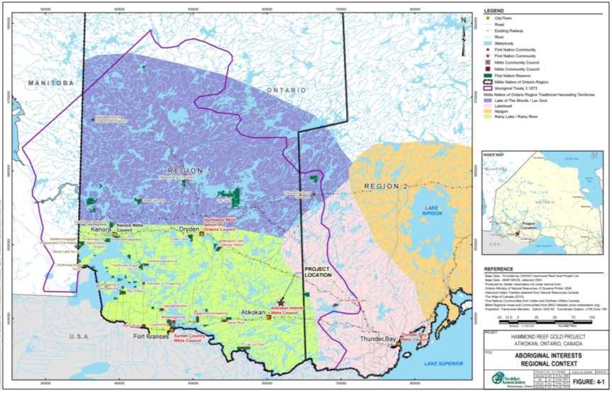
Source: Hammond Reef Gold Project Environmental Impact Statement/EA Report, Golder Associates
1.2 Environmental Assessment Process
1.2.1 Environmental assessment context
The Canadian Environmental Assessment Act, 2012 (CEAA 2012) includes transitional provisions to allow environmental assessments that began before CEAA 2012 came into force to continue under the former Canadian Environmental Assessment Act (the former Act).
Under the former Act, a project requires a federal environmental assessment if a responsible authority is contemplating certain actions or decisions that would enable the project to proceed in whole or in part. For this project, the following responsible authorities are likely to exercise certain powers, duties, or functions identified in Schedules I and II of the Law List Regulations:
- Environment and Climate Change Canada may recommend an amendment to Schedule 2 of the Metal and Diamond Mining Effluent Regulations of the Fisheries Act;
- Fisheries and Oceans Canada may take action in relation to subsection 35(2) of the Fisheries Act; and
- Natural Resources Canada may take action in relation to paragraph 7(1)(a) of the Explosives Act.
The Project is subject to a comprehensive study, as two project components are described in Part V, paragraphs 16(b) and (c) of the schedule to Comprehensive Study List Regulations under the former Act:
- metal mill with an ore input capacity of 4000 tonnes per day or more; and
- gold mine, other than a placer mine, with an ore production capacity of 600 tonnes per day or more.
The Canadian Environmental Assessment Agency (the Agency) is responsible for the conduct of the comprehensive study. In performing this role, the Agency coordinated the participation of the responsible authorities and other expert federal departments in the federal environmental assessment process, federal Crown consultation activities with Indigenous groups and the public, and federal participation in collaborative efforts with provincial ministries. The responsible authorities, the expert departments Health Canada and Transport Canada, as well as Ontario's Ministry of the Environment, Conservation and Parks, Ministry of Natural Resources and Forestry, Ministry of Energy, Northern Development and Mines, and Ministry of Tourism, Culture and Sport provided advice to the Agency in relation to their respective mandates and areas of expertise during the environmental assessment process.
The Project is also subject to an individual environmental assessment under Ontario's Environmental Assessment Act. Should Ontario issue a Notice of Approval with conditions, the Project would also require approvals and permits under several provincial statutes, including but not limited to, Environmental Compliance Approvals for air, noise, and vibrations pursuant to the Environmental Protection Act; Environmental Compliance Approval for effluent and sewage discharges and Permit to Take Water, both pursuant to the Ontario Water Resources Act; permits pursuant to the Endangered Species Act, 2007; and a Certified Closure Plan pursuant to the Mining Act.
The governments of Canada and Ontario conducted the federal and provincial environmental assessments cooperatively to the fullest extent possible, pursuant to the 2004 Canada-Ontario Agreement on Environmental Assessment Cooperation. This cooperative approach avoided unnecessary duplication of effort by all parties and stakeholders. In addition to collaborating to resolve issues during the technical review, the governments coordinated Indigenous and public consultation activities.
1.2.2 Purpose of the Comprehensive Study Report
The Agency prepared the Comprehensive Study Report (the Report) in consultation with the responsible authorities, as well as expert departments Health Canada and Transport Canada. The Report presents the Agency's analysis of whether the Project is likely to cause significant adverse environmental effects after taking into consideration the implementation of mitigation measures. The Agency's review considered the advice from the responsible authorities, the expert federal departments and provincial ministries, as well as comments provided by Indigenous groups and the public.
The federal Minister of Environment and Climate Change (the Minister) will consider the Report and comments received from the public and Indigenous groups, and may request additional information or require that concerns raised in the comments be addressed before making a decision on the significance of the adverse environmental effects and issuing the environmental assessment decision statement.
The Minister will refer the Project back to the responsible authorities following the environmental assessment decision, for their appropriate courses of action, in accordance with section 37 of the former Act.
2 Consultation
Over the course of the environmental assessment, the Agency will have provided the public and Indigenous groups three formal opportunities to participate in this comprehensive study. To date the Agency has provided comment periods on the draft Environmental Impact Statement Guidelines (August 16 to September 22, 2011) and the summary of the Environmental Impact Statement (January 17 to February 18, 2014).Footnote 2 Following the proponent's submission of an amended Environmental Impact Statement in January 2018, the Agency concluded its analysis and prepared the Comprehensive Study Report. The third participation opportunity is the 30-day comment period on this report. Notices of participation opportunities were posted on the Canadian Environmental Assessment Registry Internet Site and advertised through local media.
2.1 Public Consultation Activities
2.1.1 Public participation activities led by the Agency
Under the Agency's Participant Funding Program, $50,000 was made available to support public participation in the environmental assessment. Two applications for funding were received. Joint applicants, Atikokan Sportsmen's Conservation Club and the Ontario Federation of Anglers and Hunters, were offered $10,800. The Ontario Coalition of Indigenous Peoples was offered $7,200.
The Agency held a public open house in Atikokan on January 28, 2014. This event provided an opportunity for members of the public to hear presentations on the environmental assessment and the proponent's Environmental Impact Statement, and to provide feedback or comments. Representatives from the Ontario Ministry of the Environment, Conservation and Parks, the Ontario Ministry of Natural Resources and Forestry, and the Ontario Ministry of Energy, Northern Development and Mines, as well as the proponent, also participated in the event.
Comments received by the Agency about the Project were shared with the proponent to respond to issues raised. Submissions from the public included comments about effects on local water resources (specifically, water flows and levels) and socio-economic conditions (in relation to hydropower production). The comments were considered by the proponent in the development of its Environmental Impact Statement and by the Agency in the preparation of this report.
2.1.2 Public participation activities led by the proponent
Members of the public consulted by the proponent included local residents from the towns of Atikokan and Fort Frances, the township of Ignace, and the city of Thunder Bay. In addition, the proponent engaged other potentially affected or interested groups and individuals, including non-governmental organizations, economic development organizations, and outdoor recreation users and outfitters.
Public consultation activities by the proponent included information sharing through public notices, local print and online newspapers, and a project website; general consultation with community members at public information sessions; and meetings with key stakeholders, including the town councils of Atikokan and Ignace, the Atikokan Sportsmen's Club, and the Ontario Federation of Anglers and Hunters.
2.2 Indigenous Consultation
2.2.1 Indigenous consultation activities led by the Agency
The federal government has a legal duty to consult and, where appropriate, accommodate Indigenous groups, when it has knowledge that its proposed conduct might adversely impact rights protected under section 35 of the Constitution Act, 1982. Section 35 of the Constitution Act, 1982 recognizes and affirms existing Aboriginal and treaty rights.
In addition, the former Act requires that all federal environmental assessments consider the effect of any environmental change caused by the Project on the current use of lands and resources for traditional purposes by Aboriginal persons. The former Act also requires consideration of the effect of any project-related environmental change on physical and cultural heritage, including any structure, site, or thing that is of historical or archaeological significance.
The Agency, as Crown Consultation Coordinator for the federal environmental assessment process coordinated consultation with the Ontario Ministry of Energy, Northern Development and Mines, the provincial consultation lead, to the extent possible. The consultation processes ensured that Indigenous groups were provided with opportunities to learn about the Project, consider the potential impacts of the Project on their Aboriginal and treaty rights and current use of lands and resources for traditional purposes, communicate their concerns to the Crown, and discuss possible accommodation measures.
For the federal consultation process, the Agency identified Indigenous groups that may be adversely affected by the Project. The groups identified for federal consultation and the types of consultation activities proposed were reviewed by the Agency throughout the environmental assessment as new information was acquired.
The Agency, in considering the potential for the Project to adversely affect Aboriginal and treaty rights, identified the following ten Indigenous groups for consultation:
- Couchiching First Nation
- Lac des Mille Lacs First Nation
- Lac La Croix First Nation
- Métis, represented by the Métis Nation of Ontario Region 1 Consultation Committee
- Mitaanjigamiing First Nation
- Naicatchewenin First Nation
- Nigigoonsiminikaaning First Nation
- Rainy River First Nations
- Seine River First Nation
- Wabigoon Lake Ojibway Nation
The Agency's Participant Funding Program offered funding to each of the five Indigenous groups that applied for funds to support participation in the federal environmental assessment (Table 1).
|
Indigenous Group |
Funds Offered |
|---|---|
|
Lac des Mille Lacs First Nation |
$28,200 |
|
Seine River First Nation |
$28,200 |
|
Métis, represented by the Métis Nation of Ontario Region 1 Consultation Committee |
$28,200 |
|
Mitaanjigamiing First Nation |
$18,050 |
|
Rainy River First Nations |
$8,000 |
|
Total |
$110,650 |
On June 1, 2011, the Agency and the Ontario Ministry of Energy, Northern Development and Mines held a First Nations Consultation Workshop to determine the preferred communication methods of the First Nations. All the identified First Nations, except Lac La Croix First Nation and Rainy River First Nations attended. A similar meeting was held on July 8, 2011 with the Métis Nation of Ontario.
The Indigenous groups were invited to comment on and review key documents related to the environmental assessment, including the draft Environmental Impact Statement Guidelines (from August 16, 2011 to September 22, 2011), the Environmental Impact Statement (from January 17, 2011 to February 18, 2014), and the draft Comprehensive Study Report (March 7, 2018 to April 16, 2018). The Agency consulted on the final Comprehensive Study Report (July 30, 2018 to August 30, 2018).
Between February 10 and 13, 2014, the Agency, with the participation of the proponent, held meetings with Couchiching First Nation, Lac La Croix First Nation, Mitaanjigamiing First Nation, Naicatchewenin First Nation, Nigigoonsiminikaaning First Nation, Rainy River First Nations, and Seine River First Nation to discuss the Project, introduce the proponent's Environmental Impact Statement, and invite any comments and questions. To provide an update and invite further comments and questions on the Project and the environmental assessment process, the Agency held teleconferences with these same Indigenous groups (except Lac La Croix First Nation, due to scheduling challenges), as well as Lac des Mille Lacs First Nation and the Métis Nation of Ontario Region 1 Consultation Committee, in August and September of 2015, and between October 2016 and January 2017. A teleconference was also held with Wabigoon Lake Ojibway Nation in October 2016. Between March 12 and April 4, 2018, the Agency held meetings with Lac des Mille Lacs First Nation, Lac La Croix First Nation, Métis Nation of Ontario, Nigigoonsiminikaaning First Nation, Rainy River First Nations, Seine River First Nation, and Wabigoon Lake Ojibway Nation to provide an overview of a draft of this report and validate the Agency's analysis and conclusions. In addition, the Agency consulted with the ten identified groups throughout the environmental assessment using other methods, including phone calls, emails, and letters.
Comments received by the Agency were responded to directly or provided to the proponent to respond. The comments were considered by the proponent in the development of its Environmental Impact Statement and by the Agency in the preparation of this report. The concerns and issues raised by the Indigenous groups are presented in Appendix A. These include effects on ground and surface water; harm to fish and fish habitat; effects on terrestrial habitats and wildlife; impacts on resource and land use, including cultural sites; and site decommissioning and rehabilitation. Comments about potential impacts on Aboriginal and treaty rights, environmental monitoring, and participation of Indigenous groups during the environmental assessment and regulatory processes are also included in Appendix A. Chapters 7 and 8 describe the expected adverse environmental effects due to the Project and how the proponent proposes to address them. Project impacts on Aboriginal and treaty rights are discussed in Chapter 9.
2.2.2 Indigenous engagement activities led by the proponent
The proponent engaged with the ten Indigenous groups and offered financial support for conducting traditional land use studies and reviewing key environmental assessment and regulatory documents. The proponent met with all groups to discuss issues and conducted its own historical research studies related to Indigenous use of the area. The proponent signed a resource sharing agreement with the First Nations, except Wabigoon Lake Ojibway Nation. Through this agreement, three resource sharing committees were established. These committees meet to share information on environmental, social and economic commitments covered by the agreement and discuss any concerns throughout the project phases. These committees have established a communications plan to allow for clear communication on matters of interest. The Métis, represented by the Métis Nation of Ontario Region 1 Consultation Committee, also signed a shared interest agreement with the proponent that includes a consultation committee to address concerns.
Engagement activities jointly organized by Indigenous groups and the proponent included Elders' forums, and community events and meetings to share information on the Project, the communities, and traditional knowledge. The proponent also participated in ceremonies organized by First Nation communities.
Information collected by the proponent was taken into account by the Agency when determining whether the Project may cause adverse impacts on Aboriginal and treaty rights.
All of the Indigenous groups consulted, with the exception of Couchiching First Nation and Mitaanjigamiing First Nation, sent letters to the Agency that express support for the Project and faith in the proponent's ongoing efforts to engage with them. Mitaanjigamiing First Nation sent a letter of non-support for the Project based on the outcome of a community vote; however, the letter also expressed confidence in the ongoing engagement process to address community concerns. No views were provided by Couchiching First Nation. The Métis Nation of Ontario Region 1 Consultation Committee expressed support for the Project and informed the Agency that the community's concerns with the Project have been addressed by the proponent.
3 Project Description
3.1 Purpose of and Need for the Project
The purpose of the Project, according to the proponent, is to extract gold ore for processing at an ore processing facility to produce gold doré (alloy of gold and silver) bars for sale worldwide. The proponent anticipates the Project would contribute to economic development in Northwestern Ontario. The town of Atikokan passed a resolution in support of the Project, citing the closure of two major employers, Atikokan Forest Products and Fibra Tech. The proponent also indicated that Indigenous groups expressed an interest in employment and economic development opportunities for community members and businesses, along with an interest in sustainable development.
3.2 Project Components and Activities
3.2.1 Project components
The main project components are listed in Table 2. Figure 2 illustrates the proposed locations of the components.
|
Component |
Detail |
|---|---|
|
Mine |
The mine would consist of two open pits: the east and west pits. The area and depth of the east pit would be approximately 54 hectares and 228 metres. The west pit would be approximately 100 hectares and 318 metres deep. Mitta Lake lies within the footprint of the proposed west pit and would be drained. |
|
Waste rock management facility |
The waste rock management facility (166 hectares) would be directly east of the east pit and would be comprised of a waste rock stockpile and transfer area. Waste rock generated at the west pit would be deposited in the waste rock stockpile. Some waste rock from the east pit would backfill the west pit; the rest would be deposited in the waste rock stockpile. The waste rock management facility would include a runoff collection system. |
|
Overburden stockpile |
Soils and overburden removed to expose the ore deposit would be stored in the overburden stockpile (30 to 40 hectares). The proponent anticipates it would use some of the material to rehabilitate the site during the decommissioning phase. The stockpile would have a runoff collection system. |
|
Low-grade ore stockpile |
Low-grade ore would be stockpiled temporarily in an area (20 to 25 hectares) immediately south of the open pits to allow constant feed rates to the ore processing facility. The proponent anticipates it would process all the material from the low-grade ore stockpile by the end of the operation phase. The stockpile would have a runoff collection system. |
|
Ore processing facility |
An ore processing facility and associated infrastructure would include a crusher, conveyor, processing plant and collection pond, and effluent treatment plant. Excavated ore would be hauled to the ore processing facility, where a series of processes to produce gold doré bars from the ore would occur. Tailings produced during ore processing would be treated to reduce the level of cyanide and water content, prior to transfer to the tailings management facility. Process water would be transferred to the collection pond and an effluent treatment plant for treatment, as necessary, to comply with regulatory guidelines prior to discharge to the natural environment. |
|
Tailings management facility |
The tailings management facility (763 hectares), including containment dams and dykes, a reclaim pond and a runoff and seepage collection system, would be located northeast of the mine. The facility would store approximately 230 megatonnes of tailings. A nine kilometre tailings pipeline would connect the facility to the ore processing plant. |
|
Water management system |
The water management system would include a system to supply freshwater from an intake at the Upper Marmion Reservoir for ore processing and domestic use. With recycling and reusing of the process water in the processing plant, to the extent practicable, the proponent estimates 7200 cubic metres per day of fresh water would be required by the ore processing facility. Another 335 cubic metres per day of fresh water is estimated for domestic water supply. To manage surface runoff, the proponent proposes to include a drainage system to collect runoff from project components and transfer the runoff to the collection pond in the ore processing facility. |
|
Support and ancillary infrastructure |
Support and ancillary infrastructure would include structures such as the administration building, supply warehouse, and explosives manufacturing and storage building that would be located near the mine. |
|
Linear infrastructure |
Roads would include 26 kilometres of an existing roadway (Hardtack/Sawbill Road) that would be upgraded to connect the project site to Highway 622 and eight kilometres of new on-site roads to connect various project components. The mine would require 120 megawatts of power, which would be supplied via a new 19-kilometre, 230-kilovolt transmission line that would be connected to a substation. On-site power distribution systems would supply power to all project facilities, including the worker accommodation camp. A fibre optic line would follow the transmission line route. |
|
Sewage treatment facility |
Sewage would be treated prior to discharge to meet provincial regulatory requirements. |
|
Worker accommodation camp |
An accommodation camp to house a workforce of 1200 workers year round would be located on-site at the north end of Sawbill Bay. |
|
Aggregate |
Aggregate would be sourced from independent off-site locations to provide materials for ongoing maintenance of the road or site facilities. Some waste rock from the open pits may also serve as a source of aggregate, if it is suitable. |
Figure 2: Layout of the main project components 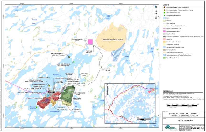
Source: Hammond Reef Gold Project Environmental Impact Statement/EA Report, Golder Associates
3.2.2 Project activities and schedule
Key project activities that would occur during each project phase are listed in Table 3. The table also shows the expected duration of each project phase. The proponent has not identified a start date for the Project, as it depends on the outcomes of the federal and provincial environmental assessment processes, as well as the outcomes of any subsequent federal authorization and provincial permitting processes.
|
Project Phase and Duration |
Project Activities |
|---|---|
|
Construction |
|
|
Operation |
|
|
Decommissioning |
|
|
Abandonment Footnote 3 |
|
4 Scope of the Assessment
4.1 Factors to Be Considered
The environmental assessment considered the following factors, which are listed in subsections 16(1) and 16(2) of the former Act and outlined in the Environmental Impact Statement Guidelines:
- environmental effects, including effects of accidents or malfunctions and cumulative effects;
- significance of effects;
- comments from Indigenous groups and the public, received in accordance with the former Act and regulations;
- technically and economically feasible mitigation measures;
- need for and purpose of the project, and alternatives to the project;
- technically and economically feasible alternative means of carrying out the project, and any associated environmental effects;
- the need for, and requirements of, any follow-up program; and
- the capacity of renewable resources likely to be affected by the Project.
4.2 Scope of the Factors
4.2.1 Identification of valued components
The environmental assessment focused on components of the biophysical and human environments that have particular value or importance and are likely to be affected by the Project. These components are termed valued components.
The proponent's process to select valued components considered the temporal and spatial scope of the Project and the predicted interactions of the Project with the environment. The selection process included a scoping exercise to identify issues related to components of the environment. Input acquired from the public, Indigenous groups, the Agency, responsible authorities, Health Canada, Transport Canada and provincial ministries informed the outcome of the exercise and selection process.
The proponent selected 36 components of the physical, biological and social environments to study for the environmental assessment. The Agency grouped 29 of the proponent's components into eight valued components, which provided a framework to evaluate the predicted changes to the environment and determine whether any adverse environmental effects the Project would cause would likely be significant. The remaining seven proponent components were excluded by the Agency as project-related changes to the environment would not affect them.Footnote 4 Tables 4 and 5 list the biophysical and social valued components, respectively, and their rationale for inclusion in the Agency's analysis.
|
Valued Component in the Environmental Impact Statement |
Valued Component Examined in the Report |
Rationale for Selection of Valued Component Examined in the Report |
|---|---|---|
|
Air quality |
Atmospheric environment |
The Project could emit air contaminants at levels that would degrade local air quality; release greenhouse gases that would contribute to atmospheric greenhouse gas levels; elevate noise levels; and create air and ground vibrations. |
|
Groundwater quantity |
Water resources |
The Project could change water flows and levels in nearby waterbodies, as well as degrade water and sediment quality. Degradation of water and sediment quality could occur due to project-related changes in soil quality and soil erosion. |
|
Aquatic environment (Fish: Walleye, Smallmouth Bass, Northern Pike, species of baitfish; Fish Habitat: lower reaches of small streams, Upper Marmion Reservoir, Lizard Lake, Mitta Lake) |
Fish and fish habitat |
The Project could cause serious harm to fish and fish habitat due to fish mortality and habitat destruction and alteration. |
|
Forest cover |
Terrestrial habitats and wildlife |
The Project could cause terrestrial habitat losses, as well as wildlife displacement and mortality that could affect populations of migratory birds, ungulates, furbearers, species at risk listed in Schedule 1 of the Species at Risk Act, and species designated by the Committee on the Status of Endangered Wildlife in Canada for inclusion in Schedule 1 of the Species at Risk Act. |
|
Valued Component in the Environmental Impact Statement |
Valued Component Examined in the Report |
Rationale for Inclusion or Exclusion of Valued Component for the Report |
|---|---|---|
|
Human health |
Human health |
The Project could increase human health risk due to exposure to degraded air quality and elevated noise levels, and due to consumption of fish, plants and wildlife harvested during socio-economic activities of local communities, as well as during traditional activities of Indigenous peoples. |
|
Outdoor tourism and recreation |
Socio-economic conditions |
The Project could disrupt or reduce outdoor recreation and tourism and other commercial activities of existing resource users due to changes in air quality, noise levels, water resources, fish and fish habitat, and terrestrial habitats and wildlife. The Project could also affect existing resource users by restricting access to resources. |
|
Traditional use of land and resources |
Current use of lands and resources for traditional purposes by Aboriginal persons |
The Project could disrupt Aboriginal fishing, harvesting, hunting and trapping activities; restrict access to areas; and degrade special sites or areas for traditional activities or gatherings. |
|
Aboriginal heritage resources |
Physical and cultural heritage resources |
The Project could disturb or remove areas or sites of physical and cultural heritage importance. |
4.2.2 Spatial and temporal boundaries
Spatial boundaries represent the geographical extent of potential environmental effects on valued components. The proponent defined four study areas to assess the environmental effects of the Project:
- Mine study area - Area that encompasses the mine, waste rock management facility, tailings management facility, water management system, overburden and low-grade ore stockpiles, ore processing facility, and the support and ancillary infrastructure (including the worker accommodation camp and sewage treatment facility).
- Linear infrastructure study area - Area that includes the access road, transmission line, and their 40-metre wide corridors.
- Local study area - The immediate vicinity around the mine and linear infrastructure study areas that could be affected by the Project.
- Regional study area - Area that provides the regional context and environmental setting of the environmental assessment.
The boundaries for the local and regional study areas were customized for the valued components to recognise the spatial extent of the various effects of the Project. Table 6 defines the local and regional study areas for the effects assessment conducted for the valued components.
Temporal boundaries represent the periods during which the effects of the Project are predicted to occur and span all project phases: construction, operation, decommissioning, and abandonment. The timing and duration of project activities and potential environmental effects on valued components during the project phases were also considered in the environmental assessment.
|
Valued |
Local Study Area |
Regional Study Area |
|---|---|---|
|
Atmospheric environment and Human health |
|
|
|
Water resources and Fish and fish habitat |
|
|
|
Terrestrial habitats and wildlife |
|
|
|
Socio-economic conditions |
|
|
|
Current use of lands and resources for traditional purposes by Aboriginal persons |
|
|
|
Physical and cultural heritage resources |
|
|
Figure 3: Local study area boundary for water resources and fish and fish habitat 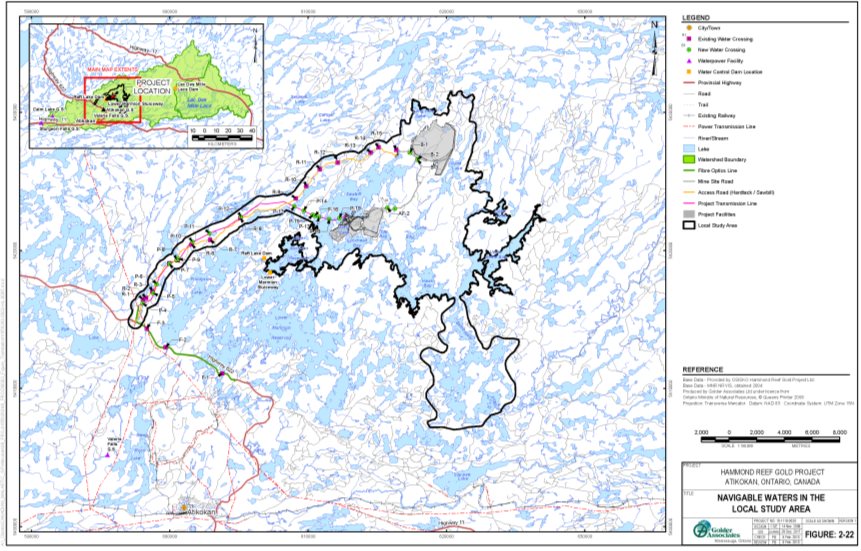
Source: Hammond Reef Gold Project Environmental Impact Statement/EA Report, Golder Associates
Figure 4: Local study area boundary for terrestrial habitats and wildlife 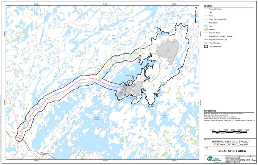
Source: Hammond Reef Gold Project Environmental Impact Statement/EA Report, Golder Associates
5 Project Alternatives
5.1 Alternatives to the Project
In its assessment, the proponent considered two options: proceeding with the Project and not proceeding with the Project. The proponent concluded that proceeding with the Project is the only option that would meet the project need, achieve the project purpose, and have socio-economic benefits without significant negative environmental effects after taking into account mitigation. Based on this rationale, the proponent indicated proceeding with the Project was the preferred option.
5.2 Alternative Means of Carrying out the Project
The proponent assessed technical and economically feasible alternative means to carry out the Project. Economic, technical, and environmental considerations were used to evaluate alternative alignments, locations, methodologies, and technologies for the following project components:
- Ore processing facility
- Sewage treatment facility
- Water management system
- Linear infrastructure (e.g. access road and transmission line)
- Worker accommodation camp
- Tailings management facility
- Waste rock stockpile
Appendix B (Table B1) summarizes the alternative means analysis for these project components. The assessment also incorporated input from Indigenous groups on avoidance of special sites and other areas of importance. The preferred options became part of the project design and were carried forward for the detailed environmental effects assessment.
There are project components and activities for which the proponent did not conduct an alternatives assessment because only a single feasible approach was identified. These cases, which appear in Appendix B (Table B2), arose due to prescribed regulatory requirements or because feasibility of the components and activities would depend on the preferred alternative means identified for other project components and activities that are described in Appendix B (Table B1).
Views expressed
Upon request from Environment and Climate Change Canada, the proponent added a fourth location for the waste rock stockpile (waste rock stockpile 4 in Appendix B (Table B1)) as an alternative. The proponent indicated that compared to the preferred alternative (waste rock stockpile 3 in Appendix B (Table B1)), waste rock stockpile 4 avoided waterbodies frequented by fish, but required a much longer haul road, which could result in higher air emissions from mobile sources, and had a higher cost. In selecting waste rock stockpile 3 as the preferred alternative, the proponent acknowledged the impact to fish and fish habitat and the requirement to comply with the Fisheries Act and Metal and Diamond Mining Effluent Regulations.
The Ontario Ministry of Natural Resources and Forestry indicated there is a requirement for a minimum setback from the shoreline of 120 metres and requested of the proponent to include alternative on-site locations for the worker accommodation camp that considers this requirement in the analysis. The proponent identified a preferred alternative that would respect the local shoreline setback requirement.
5.3 Agency's Conclusion on the Alternatives Assessment
The Agency is of the view that the proponent adequately identified alternatives to the Project and the preferred means of carrying out the Project for the purposes of the former Act and in accordance with Agency guidance (Canadian Environmental Assessment Agency, 1998 (updated 2007)). The proponent examined the alternatives to the Project and outlined its rationale for why the Project is suited to fulfill the need and purpose described in Section 3.1 of the Report.
The preferred means of carrying out the Project were identified by evaluating economically and technically feasible alternatives against economic, technical and environmental considerations. The alternative location for the waste rock stockpile identified by Environment and Climate Change Canada would have less adverse environmental effects but higher economic costs for the proponent. In choosing to remain with its initially preferred alternative, the proponent must comply with the requirements of the Fisheries Act and Metal and Diamond Mining Effluent Regulations. Input from provincial ministries and Indigenous groups was also considered by the proponent in the analysis and selection of preferred means to carry out the Project.
6 Environmental Setting
6.1 Biophysical Environment
The Project is situated within the Seine River watershed of Northwestern Ontario. The Seine River flows east to west and its main artery flows through the local study area and near the project site via Upper Marmion Reservoir. The ore deposit proposed to be mined is found within a peninsula that extends into the northwest of Upper Marmion Reservoir (Figure 2). Water from the surrounding watercourses flows into Upper Marmion Reservoir from Long Hike Lake and Sawbill Bay to the north, Lizard Lake to the northeast and from the Seine River to the east. From Upper Marmion Reservoir, water discharges west via the Raft Lake Dam to Finlayson Lake (Figure 3). Flows through the dam and water levels within the reservoir are controlled to ensure compliance with the Seine River Water Management Plan, pursuant to Ontario's Lakes and Rivers Improvement Act.
Fish species that support recreational activities, as well as traditional practices by Indigenous persons, and were observed in Upper Marmion Reservoir and other watercourses in the local study area include Walleye, Smallmouth Bass, Northern Pike, and various species of baitfish.
The setting is characterized by a dense cover of deciduous, coniferous and mixed forest. Cuts or depleted forest range from three to six percent coverage. Dominant species include jack pine, balsam fir, black and white spruce, trembling aspen and white birch in upland areas. Marshes, swamps, fens and bogs are also present and are dominated by black spruce, tamarack willows and alders.
Wildlife surveys conducted by the proponent identified several mammalian species, including bats that are species at risk (Northern Myotis and Little Brown Myotis), moose and furbearers of economic importance and used for traditional purposes of Indigenous peoples (martin, muskrat). Bird species, including nine raptors, were identified. Other observed species include two migratory birds that are also federally listed species at risk, Canada Warbler and Common Nighthawk. Amphibians and reptiles were also identified, including the Snapping Turtle, a species at risk.
6.2 Human Environment
The Project is located within the Rainy River District, approximately 170 kilometres west of the city of Thunder Bay (population of 124 200), the largest population centre in Northwestern Ontario.Footnote 5 The nearest town is Atikokan, approximately 23 kilometres to the southwest of the Project. Fort Frances, the third largest community in Northwestern Ontario, is approximately 150 kilometres to the west. The project site can be accessed via Highway 622. Highway 622 intersects Highway 11, just south of Atikokan.
The Project lies within the Treaty 3 (1873) area of Ontario (Figure 1). It is also within an area that the Métis, represented by the Métis Nation of Ontario, have identified as the Treaty 3/Lake of the Woods/Lac Seul/ Rainy Lake/Rainy River Region 1 traditional harvesting area. Treaty 3 is an historic agreement that provides for the exercise of fishing and hunting rights. Fishing and hunting occur within the region. Other traditional uses of the lands and resources include trapping, plant harvesting, and use of special sites. Lac des Mille Lacs First Nation, Lac La Croix First Nation and Seine River First Nation have communities and reserve lands within the socio-economic local study area.
Tourism is an important industry to local communities and some Indigenous groups. There are camping sites, trapper cabins, and tourism establishments in the local study area. The area also hosts the Atikokan Bass Classic, a fishing tournament that is estimated to contribute over one million dollars annually to the local economy. Other resource-based activities that employ Indigenous persons include wild rice harvesting, trapping, and forestry operations.
Historically Atikokan's economy has been largely dependent on the mining and forestry industries. Two iron ore mines, Steep Rock and Caland, which operated from the early 1950s to 1979, and a thriving forestry industry once dominated the local economy. Today, there is just one fuel pellet manufacturing facility still in operation. Many residents employed in the mining and forestry industries travel outside of Atikokan for work. Other important local economic activities include light manufacturing, government and retail services, and hydropower generation. Of these industries, forestry and hydropower generation continue to use the renewable resources within the local study area for their operations.
7 Environmental Effects Assessment
7.1 Approach to the Environmental Effects Assessment
To conduct its analysis, the Agency considered: the proponent's environmental impact statement, views expressed by federal departments and provincial ministries, comments received from Indigenous groups and the public, as well as the proponent's responses to the views and comments. The Agency also considered the existing environmental conditions, the predicted adverse effects on the valued components, and mitigation measures (Appendix C) proposed by the proponent to address those effects.
To determine the likely significance of the adverse effects after implementation of the proposed mitigation measures, the Agency based its approach on the methodology set out in Reference Guide: Determining Whether a Project is Likely to Cause Significant Adverse Environmental Effects.
The Agency characterized the residual adverse effects on valued components by using the following assessment criteria:
- Magnitude: Severity of the adverse effect
- Geographic Extent: Spatial reach of the adverse effect
- Duration: Length of time a valued component would be affected by the adverse effect
- Frequency: Rate of recurrence of the adverse effect
- Reversibility: Degree to which the environmental conditions can recover after the adverse effect occurs.
Each criterion was assigned an effects rating (low, moderate or high for the first four criteria; reversible, partially reversible, or irreversible for Reversibility), based on the definitions described in Appendix D. The Agency determined the likelihood that adverse effects would be significant using assessment criteria and ratings. A summary of the effects and their significance is presented in Appendix E.
In some instances, the Agency recommended development of follow-up program measures (Appendix F) by the responsible authorities to address areas of uncertainty inherent in effects assessment prediction or mitigation measures. The Agency also identified the anticipated federal and provincial regulatory requirements that would address environmental effects, mitigation, and monitoring.
This chapter presents the effects analysis for each valued component. Each section begins with a summary that is followed by subsections to describe the adverse environmental effects. The subsections include the proponent's assessment, views expressed, Agency analysis and conclusion, and a summary of mitigation and follow-up program measures.
7.2 Atmospheric Environment
The Agency is of the view that the Project is not likely to cause significant adverse effects on air quality, contributions to the national greenhouse gas emissions inventory, or noise and vibrations, after taking into account implementation of the proposed key mitigation measures (Box 1-1). A follow-up monitoring measure for air quality (Box 1-2) is recommended to verify the air quality assessment predictions. The Agency's conclusions are based on its analysis of the proponent's assessments, views expressed by federal departments, provincial ministries, as well as Indigenous groups (Appendix A).
7.2.1 Air quality
7.2.1.1 Proponent's Assessment
Existing Environment
The proponent indicated that existing air quality within the local study area is representative of Northern Ontario given the Project would be located in a remote area, far from industrial air contaminant emissions. Since there were no proximate air quality monitoring stations, the proponent used data from several monitoring stations across Canada with comparable circumstances to estimate existing concentrations of particulate matter (TSP, PM10 and PM2.5), combustion gases (such as carbon monoxide, nitrogen dioxide and sulphur dioxide) and other compounds expected to be emitted by the Project. The data suggested air quality in a remote setting such as the Project's location would have concentrations of particulate matter and combustion gases below the Canadian Ambient Air Quality Standards and the Ontario's Ambient Air Quality Criteria. The proponent assumed that existing concentrations for other compounds without air quality measurements, such as hydrogen cyanide and ammonia, were zero.
Effects and Mitigation
The proponent predicted residual environmental effects on air quality that would occur in the local study area, primarily within two kilometres of the mine study area. Changes in air quality include increased levels of particulate matter (TSP, PM10 and PM2.5) and combustion products other than greenhouse gases (acrolein and sulphur dioxide). The increased levels would be from project activities such as: material handling, bulldozing and grading; use of unpaved roads; use of explosives in the open pit; operation of vehicles, generators and heaters; and ore processing. These activities, and their associated releases of air contaminants, would occur at the highest frequencies and intensities during the construction and operation phases.
Table 7 presents the maximum concentrations and frequencies of air quality criteria exceedance that were predicted in the proponent's air quality modeling. The modeling results indicate particulate matter (TSP, PM10 and PM2.5) concentrations in the local study area would exceed the criteria at annual frequencies between seven percent and 44 percent (between 26 days and 160 days per year). According to the proponent, maximum concentrations of respirable particulates (PM10) may exceed criteria outside the local study area less than one day per year under worst-case meteorological conditions.
Acrolein, which is released in tailpipe emissions, would exceed the air quality criterion in the local study area at a frequency of 24 percent (approximately 88 days per year).
Maximum concentrations of sulphur dioxide in the local and regional study areas would exceed the new one-hour Canadian Ambient Air Quality Standard for sulphur dioxide, once the more stringent standard comes into effect in 2020 and is again changed in 2025. (At the time of modeling, the proponent was unaware of the new standard. As a result the frequency of exceedance for sulphur dioxide was not determined.) The proponent indicated that the predicted exceedance stems from assumptions of excessive use of sulphur dioxide in the cyanide destruction circuit and simultaneous operation of all vehicles and equipment, including emergency generators. According to the proponent, this operating scenario is unlikely. Further, conditions within the Environmental Compliance Approval pursuant to Ontario's Environmental Protection Act would set performance requirements for stationary emission sources.
These predictions assume the implementation of mitigation measures (Box 1-1) to control emissions, such as road watering, wet drilling and using filters and scrubbers on vents and stacks. According to the proponent, the air quality model was based on an operating scenario that reflected the highest waste rock extraction rate, longest haul distance, maximum ore processing rate, maximum vehicle fleet in use, and all project equipment operating continuously. As a consequence, the results likely overestimate what can be expected.
|
Indicator Compound |
Averaging Period |
Air Quality Criteria (a) |
Baseline Concentration |
Maximum Concentration |
Maximum Frequency |
||
|---|---|---|---|---|---|---|---|
|
Local Study Area |
Regional Study Area |
Local Study Area |
Regional Study Area |
||||
|
(a) most stringent of National Ambient Air Quality Objectives, Canadian Ambient Air Quality Standards and Ontario's Ambient Air Quality Criteria (b) micrograms of indicator compound per cubic metre of air (c) The criteria for fine particulates and sulphur dioxide (Canadian Ambient Air Quality Standards) will be effective in 2020 and 2025, respectively. (d) N.D. = Not Determined (e) Exceedance occurs within two kilometres of the mine study area during the peak operating years |
|||||||
|
Particulate matter |
|||||||
|
Total suspended particles (TSP) |
24 hour |
120 |
--- |
631 |
97 |
38 |
--- |
|
Annual |
60 |
--- |
129 |
7 |
--- |
--- |
|
|
Respirable particulates (PM10) |
24 hour |
50 |
17.8 |
248 |
57 |
44 |
0.2 |
|
Fine particulates (PM2.5)(c) |
24 hour |
27 |
4.9 |
52 |
14 |
7 |
--- |
|
Annual |
8.8 |
--- |
9 |
1 |
--- |
--- |
|
|
Combustion products other than greenhouse gases |
|||||||
|
Acrolein |
24 hour |
0.4 |
--- |
1.58 |
0.29 |
24 |
--- |
|
Carbon monoxide |
1 hour |
35 000 |
1150 |
3227 |
1915 |
--- |
--- |
|
8 hour |
15 000 |
1160 |
2320 |
1587 |
--- |
--- |
|
|
Nitrogen dioxide |
1 hour |
400 |
2.32 |
335 |
166 |
--- |
--- |
|
24 hour |
200 |
2.32 |
116 |
67 |
--- |
--- |
|
|
Annual |
100 |
--- |
55 |
4 |
--- |
--- |
|
|
Sulphur dioxide(c) |
1 hour |
170 |
2.6 |
871 |
200 |
N.D. (d) |
N.D. (d) |
|
Annual |
10.5 |
--- |
2 |
1 |
--- |
--- |
|
Figure 5 shows the locations where the maximum concentrations of particulate matter and combustion products would occur, according to the proponent's modeling.
Figure 5: Locations of predicted maximum airborne contaminant concentrations 
Source: Hammond Reef Gold Project Environmental Impact Statement/EA Report, Golder Associates
7.2.1.2 Views Expressed
Environment and Climate Change Canada and the Ontario Ministry of the Environment, Conservation and Parks requested revisions to the air quality modeling to better reflect emission source contributions, expected efficiencies of mitigation measures, and effects in the local and regional study areas. The request also called for additional mitigation to minimize vehicle emissions, as well as updates to the proposed air quality monitoring plan to ensure that all contaminants emitted at concentrations above established air quality limits would be monitored and reported. The proponent revised the modeling assumptions to use average daily emission rates from sources expected to be in operation during the maximum waste rock haulage year of the Project. The proponent also indicated that the majority of off-road vehicles in the fleet would meet Tier 4 emission standards, thereby reducing tailpipe emissions.Footnote 6 Further, the proponent revised the monitoring plan to incorporate a two-stage approach, whereby stage one would establish the baseline trends to determine when higher levels could occur, and stage two would include focused sampling that would be informed by the baseline trends and consultation with federal and provincial agencies.
Environment and Climate Change Canada requested that the proponent identify measures to manage sulphur dioxide emissions as new Canadian Ambient Air Quality Standards for sulphur dioxide are scheduled to come into effect in 2020 and further changes are expected in 2025. The proponent indicated that use of sulphur dioxide in the cyanide destruction circuit would be the primary emission source. The modeling assumed an excess amount of sulphur dioxide would be used and subsequently emitted. According to the proponent, the actual emission rate would be lower and likely would result in concentrations below the new standards. Further, the proponent indicated that source testing to monitor the circuit performance would occur in accordance with the Environmental Compliance Approval for air emissions that would be required from the Ontario Ministry of the Environment, Conservation and Parks, pursuant to Ontario's Environmental Protection Act. In addition, the proponent committed to monitor air quality at locations close to the mine study area that would be subject to approval by the Ontario Ministry of the Environment, Conservation and Parks to identify the need for corrective action to reduce emissions to comply with the air quality criteria.
7.2.1.3 Agency Analysis and Conclusion
The Agency notes that the proponent's air quality modeling predicted that, taking into account the implementation of proposed mitigation measures (Box 1-1), particulate matter (TSP, PM10 and PM2.5) and combustion products other than greenhouse gases (acrolein and sulphur dioxide) would exceed air quality criteria within two kilometres from the mine study area. The Agency also notes that the proponent predicts an exceedance of the respirable particulates (PM10) air quality limit could also occur in the regional study area, but does not consider this a likely event. The Agency recognizes that the modeling results reflect predictions for the peak operating year, not the life of the Project, and that the proponent used conservative assumptions. The Agency is of the view that exceedances in the regional study area are unlikely.
The Agency is of the view that the predicted contaminant exceedances would occur during the construction and operation phases and to a lesser extent during the decommissioning phase, due to demolition and site stabilization activities, and that these effects would cease once project activities are completed. Further, the Agency recommends follow-up program measures (Box 1-2) to evaluate the effectiveness of the mitigation during the construction, operation and decommissioning phases to determine the need for adaptive management to meet air quality criteria within the local study area.
Considering implementation of the proposed mitigation measures for air quality and the definitions of the environmental effects rating criteria in Appendix D, the magnitude of effects would be rated as high since concentrations for particulate matter (TSP, PM10 and PM2.5) and combustion products other than greenhouse gases (acrolein and sulphur dioxide) were predicted to be above the limits set in the Canadian Ambient Air Quality Standards or Ontario's Ambient Air Quality Criteria. These exceedances would be experienced within the local study area, so the geographic extent is rated as moderate. The duration of this effect is rated as moderate since the effect on air quality would occur during the construction and operation phases and part of the decommissioning phase (approximately 15 years of the project life). The frequency would be rated as moderate since exceedances could happen several times per month. The effect would be reversible as airborne contaminant releases would cease once the emission sources stopped operating and the site is revegetated and stabilized.
Taking into account the proposed mitigation measures (Box 1-1), the Agency concludes the Project is not likely to cause a significant adverse effect on air quality.
The effects of the predicted changes to air quality on receptors, such as terrestrial wildlife and humans entering the local study area are considered in the Agency's analysis of effects on terrestrial wildlife, human health, socio-economic conditions and current use of lands and resources for traditional purposes by Aboriginal persons (Sections 7.5, 7.6, 7.7 and 7.8).
7.2.2 Greenhouse gas emissions
7.2.2.1 Proponent's Assessment
Effects and Mitigation
According to the proponent, greenhouse gas emissions from the Project (carbon dioxide, methane and nitrous oxide) would result primarily from the operation of mobile equipment and vehicles. The proponent estimated the maximum annual greenhouse gas emissions for mobile and non-mobile sources using the anticipated conditions during peak operations. The calculations indicate that total direct emissions would be 195 624 tonnes of CO2 equivalent annually over the life of the Project, of which 28 085 tonnes of CO2 equivalent would be from non-mobile sources.Footnote 7 The proponent indicated that the total direct emissions would be approximately 0.11 percent of the total greenhouse gas emissions from Ontario in the 2010 reporting year. Table 8 provides a breakdown of the predicted greenhouse gas emissions from the Project during the maximum operating year.
|
Greenhouse Gas |
Annual Emissions |
|
|---|---|---|
|
(tonnes) |
(tonnes of CO2 equivalent) |
|
|
Stationary Equipment and Process Sources (non-mobile) |
||
|
Carbon dioxide |
27 537 |
27 537 |
|
Methane |
0.4 |
8.2 |
|
Nitrous oxide |
1.7 |
540 |
|
All Sources (mobile and non-mobile) |
||
|
Carbon dioxide |
192 041 |
192 041 |
|
Methane |
7.2 |
150.9 |
|
Nitrous oxide |
11.1 |
3432 |
|
Total Tonnes of CO2 equivalent |
195 624 |
|
Emission monitoring and reporting would occur as required under Environment and Climate Change Canada's Greenhouse Gas Reporting Program pursuant to the Canadian Environmental Protection Act, 1999 and Ontario's O.Reg. 143/16: Quantification, Reporting and Verification of Greenhouse Gas Emissions Regulation. In addition, the proponent committed to implement a greenhouse gases management plan that adheres to Environment and Climate Change Canada's Environmental Code of Practice for Metal Mines. The plan would contain mitigation measures, including utilizing fuel efficient equipment, conducting regular and routine vehicle maintenance, as well as shortening vehicle travel distances to control emissions.
7.2.2.2 Views Expressed
Environment and Climate Change Canada commented that the greenhouse gas emission estimate calculations did not use updated emission factors and global warming potentials.Footnote 8 The proponent responded that the estimate is based on conservative calculations and assumes the maximum vehicle fleet is in continuous use (24 hours per day, 365 days per year). In addition, the emission estimates are based on fuel consumption and most emissions are in the form of carbon dioxide. Any changes in global warming potential for methane or nitrous oxide would cause a small change in total emissions from the Project. Therefore, the proponent is of the view that the calculation represents a fair, upper limit estimate of the emission rate for these sources. Environment and Climate Change Canada accepted this response.
The Ontario Ministry of the Environment, Conservation and Parks requested an estimate of indirect emissions from the generation of purchased electricity, heat or steam and asked how the removal of carbon sinks would affect the total greenhouse gas emission estimate. The proponent responded that indirect emissions during the maximum operating year would not exceed approximately 52 560 tonnes of CO2 equivalent. The proponent indicated that the loss of carbon sinks due to tree clearing would be a one-time activity not comparable to the greenhouse gases emitted annually over the life of the Project. Further, the removal of the trees would occur at the beginning of the Project, when total emissions would be lower than the emissions expected during the peak operating period.
7.2.2.3 Agency Analysis and Conclusion
Greenhouse gas emissions from Ontario have dropped from 174 000 kilotonnes of CO2 equivalent for the 2010 reporting year to 160 600 kilotonnes of CO2 equivalent for the 2016 reporting year. As such, the relative percentage of the predicted emission estimate for the Project would be slightly higher, at approximately 0.12 percent of the provincial emissions for the 2016 reporting year. The Agency considers the volume of greenhouse gas emissions from the Project, up to approximately 195 624 tonnes of CO2 equivalent during the maximum operating year, to be low in magnitude compared to Ontario's greenhouse gas inventory.
Therefore, the Agency concludes that the Project is not likely to contribute significantly to national greenhouse gas emission levels.
The proponent has committed to incorporate greenhouse gas emission management measures that adhere to Environment and Climate Change Canada's Environmental Code of Practice for Metal Mines, and the Project would be subject to federal and provincial regulatory reporting.
7.2.3 Noise and vibrations
7.2.3.1 Proponent's Assessment
Effects and Mitigation
The noise assessment focused on the operation phase as the proponent indicated that this phase would involve the greatest amount of equipment with the highest noise emission levels. The proponent predicted that activities within the mine study area would raise noise levels above pre-project conditions during the day (from 40 to 50 A-weighted decibels) and at night (from 35 to 50 A-weighted decibels) in parts of the local study area within approximately three kilometres of the noise sources within the mine study area, despite implementation of mitigation measures such as equipment mufflers and enclosures. The predicted levels would exceed the thresholds established in Ontario's Environmental Noise Guideline (NPC-300) of 45 A-weighted decibels for day and 40 A-weighted decibels for night. The modeling assumed that all project equipment and vehicles would be running continuously at the level of peak operation throughout the 11-year operation phase, and that the pit depth and stockpile heights would provide little noise shielding.
According to the proponent, the primary noise sources would include vehicle and equipment operations, blasting, and ore extraction and processing. Figure 6 shows the extent of elevated noise levels from the mine study area during the operation phase. High noise levels would also occur during construction and decommissioning phases due to project activities such as site grading and demolition. In addition, road noise from heavy trucks on the access road could exceed provincial guidelines within 1100 metres from the centre line of the road.
Blasting activities release energy that would cause air and ground vibrations. The proponent's modeling predicted no adverse environmental effects from air and ground vibrations. The maximum air blast overpressure level estimated at the nearest human receptor location (POR23 in Figure 6) is 113 decibels, which is below Ontario's NPC-119: Blasting guideline limit of 128 decibels. The maximum blast-induced ground vibration level that was predicted at the same location is 2.65 millimetres per second, which is below the guideline limit of 12.5 millimetres per second for peak ground vibrations. Further, the proponent also indicated that air and ground vibrations would decrease with distance from the blasting location and would not be detected outside of the local study area. Nonetheless, the proponent committed to monitor the air and ground vibrations to verify the accuracy of the predictions and determine whether adaptive management would be required to comply with the guideline limits.
7.2.3.2 Views Expressed
No views were expressed with respect to the analysis of noise and vibrations. Comments about effects from noise on terrestrial wildlife, human health, socio-economic conditions, and current use of lands and resources for traditional purposes by Aboriginal persons are covered in Sections 7.5, 7.6, 7.7 and 7.8 of this report.
Figure 6: Predicted extent of elevated noise levels
(Note: The points of reception nearest the mine study area: POR10, POR36 and POR37 are non-designated camping sites. POR23 is a tourism establishment that is not in use.)

Source: Hammond Reef Gold Project Environmental Impact Statement/EA Report, Golder Associates
7.2.3.3 Agency Analysis and Conclusion
The proponent's assessment predicted exceedance of Ontario's environmental noise guideline (NPC-300), while peak vibration levels would comply with provincial limits. The assessment showed that taking into account the implementation of mitigation measures (Box 1-1), maximum noise levels within the local study area would exceed the guideline within three kilometres of the noise sources in the mine study area and within the access road corridor during the peak operating period and periods of heavy truck traffic. The Agency is aware that the Ontario Ministry of the Environment, Conservation and Parks would require an Environmental Compliance Approval for noise and vibrations pursuant to the Environmental Protection Act. This approval would outline the performance standards for the Project. Further, the proponent would be required to take corrective action as needed, to reduce elevated levels in order to adhere to the conditions of the Environmental Compliance Approval.
Given the proposed mitigation measures and the definitions of the environmental effects rating criteria in Appendix D, the effects due to noise and vibration levels would be rated as high in magnitude since the noise levels at some locations outside the mine study area and site access road corridor could exceed thresholds set in Ontario's Environmental Noise Guidelines (NPC-300). The geographic extent of the effects is rated as moderate as the exceedances would occur in the local study area. The duration is rated as moderate as elevated noise levels would occur primarily during construction and operation phases. The frequency is rated as high since the noise levels would be constantly elevated during the operation phase. The effects would be reversible as noise levels would return to baseline conditions once project activities cease.
Taking into account the implementation of the proposed mitigation measures (Box 1-1), the Agency concludes the Project is not likely to cause significant adverse effects on the atmospheric environment due to noise and vibrations.
How the elevated noise levels would affect terrestrial wildlife, land uses, human health, socio-economic conditions, and current use of lands and resources for traditional purposes by Aboriginal persons is discussed in Sections 7.5, 7.6, 7.7, and 7.8. Effects on fish and fish habitat due to underwater overpressure from blasting near the shoreline are discussed in Section 7.4.
Box 1-1: Key mitigation measures to address effects on the atmospheric environment
Mitigation Measures to Control Air Emissions
- Implement best management practices during the construction, operation, and decommissioning phases to control fugitive particulate emissions, including road watering, wet drilling, and minimizing distances and drop heights for material handling and waste rock stockpiling, in accordance with the Environmental Compliance Approval required from the Ontario Ministry of the Environment, Conservation and Parks pursuant to Ontario's Environmental Protection Act.
- Maintain non-road vehicles used for mine operations during the construction, operation, and decommissioning phases to control tailpipe emissions.
- Use fabric filters, scrubbers, and enclosures at the ore processing facility as needed to limit air contaminant emissions during the operation phase in accordance with the Environmental Compliance Approval required from the Ontario Ministry of the Environment, Conservation and Parks pursuant to Ontario's Environmental Protection Act.
Mitigation Measures to Limit Greenhouse Gas Emissions
- Minimize fuel consumption during the construction, operation, and decommissioning phases by implementing best operating practices that include using fuel efficient equipment, conducting regular and routine vehicle maintenance, and minimizing vehicle travel distances.
Mitigation Measures to Reduce Noise Levels
- Install and maintain equipment mufflers and enclosures as necessary during the construction, operation, and decommissioning phases to control noise levels in accordance with the Environmental Compliance Approval required from the Ontario Ministry of the Environment, Conservation and Parks pursuant to Ontario's Environmental Protection Act.
Box 1-2: Follow-up program measure recommended for air quality
Air Quality Follow-Up Program Measure
- Monitor levels of particulate matter (TSP, PM10 and PM2.5) and combustion products (acrolein and sulphur dioxide) during the construction, operation, and decommissioning phases at locations pre-determined with input from federal and provincial agencies to verify the levels within the local study area are less than or as predicted during the environmental assessment. If air quality criteria are exceeded, implement adaptive measures required to meet criteria.
7.3 Water Resources
The Agency is of the view, after taking into account the implementation of the proposed key mitigation measures (Box 2-1), the Project is not likely to cause significant adverse effects on water flows and levels, and water quality. Follow-up monitoring measures for water quality (Box 2-2) are recommended to verify the predicted water quality and evaluate the effectiveness of the proposed mitigation measures. The Agency's conclusions are based on its analysis of the proponent's assessments as well as the views expressed by federal departments, provincial ministries and Indigenous groups.
7.3.1 Water flows and levels
7.3.1.1 Proponent's Assessment
Existing Environment
Upper Marmion Reservoir is a controlled waterbody within the local study area that spans a series of basins from Sawbill Bay to Lynxhead Bay (Figure 7). The reservoir surrounds the mine study area on three sides, with the exception of the tailings management facility. Lizard Lake, which is east of the proposed tailings management facility, drains southwest into Upper Marmion Reservoir via Turtle Bay. The main tributaries that drain into Upper Marmion Reservoir (Figure 8) from east to west are Caribou River (via Upper Seine Bay), Light Creek (in the Light Bay watershed), Lumby Creek (via Lizard Lake and Turtle Bay) and Sawbill Creek (via Sawbill Bay). The project site does not include any of these tributaries.
Surface water flows and levels within Upper Marmion Reservoir are managed by the signatories to the Seine River Water Management Plan for multiple water uses downstream, including flood control, sustaining walleye spawning flows and storage for water power production. Footnote 9 The water flows and levels are maintained by operation of the Raft Lake Dam, at the westernmost tip of the reservoir. Water drains west from the dam into Finlayson Lake.
Figure 7: Major waterbodies within the local study area
(Note: The pink squares indicate existing water crossings; green circles represent new water crossings.)

Source: Hammond Reef Gold Project Environmental Impact Statement/EA Report, Golder Associates
Figure 8: Main tributaries within the Seine River local watersheds
(Note: The arrows show the main tributary locations and draining directions.)
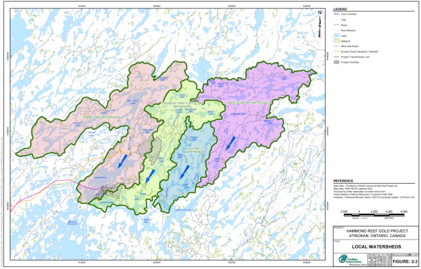
Source: Hammond Reef Gold Project Environmental Impact Statement/EA Report, Golder Associates
The proponent indicated that the water level in Upper Marmion Reservoir fluctuates annually by more than two metres on average due to flood control and downstream demand. For Lizard Lake, the water level fluctuates annually by approximately five centimetres.
Effects and Mitigation
The proponent predicts negligible residual effects on water flows and levels in Upper Marmion Reservoir, after implementation of mitigation measures (Box 2-1). The project site would not overprint the main tributaries which flow into the reservoir (Figure 8). However, project activities, such as dewatering of Mitta Lake to accommodate the west pit, site grading, water taking, as well as run-off diversion and interception, would redirect water flows and alter site drainage areas for run-off flowing towards the reservoir. The reduction to the tributary drainage area of the reservoir due to the project site would be minimal, at one third of a percent. In addition, the monthly mean outflows from the reservoir would be reduced by 4.9 percent. The proponent indicated that this change in flows would not be measurable in the field. The proponent also expects to stabilize the site and return site drainage to near pre-project conditions during the decommissioning phase.
The Project would require water from Upper Marmion Reservoir. The proponent proposes to minimize the decrease in water levels within the reservoir by using the water management system. The system would collect and store water from dewatering the pits, as well as by diverting run-off and seepage to water management ponds, and recycling the water for use in project activities. To counterbalance water taking, the proponent would release water from the management system after treatment into the reservoir through controlled discharge locations (sewage and mine effluent discharges) when necessary. Seepage and run-off entering the pits would be collected by the mine dewatering system and transferred to the water management ponds for storage and reuse. The water management system would also take water from the reservoir during wet periods (under high flow conditions) to store on-site for later use.
The proponent indicated that while reusing recycled water would be possible for some mine operations, freshwater would be required for domestic uses and reagent mixing. According to the proponent, the maximum decrease in reservoir water levels would be primarily due to ore processing (approximately 34 898 cubic metres per day during the maximum production year), dust control (approximately 3320 cubic metres per day) and water taking for domestic uses (approximately 335 cubic metres per day). Further, the proponent predicted up to 523 cubic metres per day of water would seep into the open pits from the reservoir by the end of mining (after 11 years of operation). During the decommissioning phase, water demand would decrease as ore processing would no longer occur. The proponent estimates that measures to store and reuse water on site would result in a maximum water level reduction of nine centimetres in Upper Marmion Reservoir compared to baseline. This reduction is considerably less than normal reservoir annual fluctuations, which can exceed two metres.
Near the tailings management facility at Lizard Lake, lake flows and levels are influenced by Lumby Creek. Monthly mean flows through Lumby Creek could decrease up to 7.7 percent during the spring due to lost drainage area. The tailings management facility, including the perimeter collection system, would avoid Lumby Creek and the main drainage flows into Lizard Lake. The drainage area for Lizard Lake would decrease up to 6.9 percent. The proponent indicated that the change in drainage would be proportional to the change in flows entering the lake. For water levels, the proponent predicted a maximum annual decline of 2.7 centimetres in Lizard Lake. This decline is less than the normal lake fluctuation of five centimetres. Therefore, the proponent expects the project effects on Lizard Lake to be low.
7.3.1.2 Views Expressed
In response to questions from Transport Canada about the navigability of the waterbodies and waterways in the mine study area, including Mitta Lake, the proponent provided Transport Canada information about the waterbodies and waterways, such as maximum dimensions (length, width, and depth), flows, and connectivity between waterbodies and waterways. Transport Canada concluded that as described in the Environmental Impact Statement, the waterbodies and waterways in the mine study area are non-navigable under the Navigation Protection Act and the Project would not impede navigation in the local study area.
The Ontario Ministry of the Environment, Conservation and Parks requested that the proponent monitor drainage courses that flow into Upper Marmion Reservoir and would be affected by the Project to maintain adequate pre-project data. The proponent responded that monitoring was reinstated in September 2015 and a new station was added on the Seine River near the bridge at Premier Lake Road.
Other comments regarding project effects on water flows and levels relate to effects on hydropower production capacity, and are discussed in Section 7.7 of this report.
7.3.1.3 Agency Analysis and Conclusion
The Project would have negligible to low residual effects on water flows and levels, after implementation of mitigation measures. The Agency notes that the project site avoids main tributary flows into Upper Marmion Reservoir and Lizard Lake. As a result, the reduction in drainage areas to Upper Marmion Reservoir and Lizard Lake would cause an indiscernible change (less than 10 percent) in flows to those waterbodies. Regarding water levels, project activities would require water from the reservoir, but given the proponent's commitments to recycle water in the water management system, intercept and collect runoff, collect and treat seepage, and extract and store water during wet periods, the Agency is of the view that changes to reservoir levels would be minimal. Changes in water levels in Lizard Lake would be linked to changes in flows as there would be no water taking from the lake by the Project. Therefore, given the Project would avoid the main tributary flows to Lizard Lake, the Agency accepts that changes in lake level would be within normal fluctuations. The Agency also accepts that the Project would not impede navigation in the local study area.
The Agency is aware that the Permit to Take Water, which would be required by the Ontario Ministry of the Environment, Conservation and Parks pursuant to the Ontario Water Resources Act, would regulate the amount of water taken from the reservoir. Furthermore, as discussed in Section 7.7 of this report, conditions for the permit would avoid conflict with the Seine River Water Management Plan. During the decommissioning phase, water flows and levels within both Upper Marmion Reservoir and Lizard Lake would differ from pre-project conditions as site water would be diverted to flood the open pits. However, the Certified Closure Plan pursuant to Ontario's Mining Act would require site stabilization and a return to near pre-project conditions.
Given the proposed mitigation and the definitions of the environmental effects rating criteria in Appendix D, the effect on the water flows and levels in Upper Marmion Reservoir and Lizard Lake is rated as low in magnitude as changes in water flows would not be measurable and changes in levels would be within normal fluctuations. The geographic extent is rated as moderate since the effect would occur within the local study area. The effects rating for duration is high, given the changes in flows and levels would occur during construction, operation, and decommissioning phases. The frequency is rated as moderate since the effect would occur several times per month, depending on whether conditions are drier than normal. The effect would be partially reversible as site drainage would return to near pre-project conditions in the abandonment phase.
Taking into account the proposed mitigation measures, the Agency concludes the Project is not likely to cause significant adverse effects on water flows and levels.
The effects of the changes in surface water flows and levels on fish and fish habitat, and socio-economic conditions, are discussed in Sections 7.4 and 7.7 respectively.
7.3.2 Water quality
7.3.2.1 Proponent's Assessment
Existing Environment
The proponent reported that 35 percent of collected water samples from Upper Marmion Reservoir show levels of pH, phosphorus and metals (including aluminum, copper and iron) that exceed Canadian Water Quality Guidelines for the Protection of Aquatic Life or Provincial Water Quality Objectives. For Lizard Lake, water quality parameters were within the Canadian Water Quality Guidelines for the Protection of Aquatic Life and the Provincial Water Quality Objectives, except for aluminum levels in 36 percent of the samples.
The groundwater table in the vicinity of the mine study area is relatively shallow (approximately four metres below ground) and discharges in flat, low-lying areas to surface waterbodies, including Upper Marmion Reservoir and Lizard Lake. Aluminum, arsenic, zinc, cadmium, uranium, silver and vanadium concentrations in groundwater samples exceed Provincial Water Quality Objectives.
Effects and Mitigation
The proponent indicated that effects on water quality due to the Project would be limited as the waste rock and tailings would not be acid generating; however, metal leaching would occur. Further, ore processing activities would produce wastewater that contains contaminants such as copper, cyanide and sulphate. As a result, the proponent proposes to use a cyanide destruction circuit and a mine effluent treatment facility to reduce contaminant levels as necessary to meet federal and provincial discharge quality requirements. The proponent also committed to use the water management system to collect and divert contaminated water for treatment prior to discharge through a controlled discharge point in Upper Marmion Reservoir.
Despite these mitigation measures to treat the mine effluent prior to discharge into Upper Marmion Reservoir, the proponent predicted that contaminant concentrations, specifically copper, cyanide, and sulphate, would rise; however, the increases would be small (Table 9). Copper concentrations in the reservoir would rise further above the Canadian Water Quality Guidelines for the Protection of Aquatic Life and the Provincial Water Quality Objectives, from 0.0021 milligrams per litre to 0.0028 milligrams per litre. Sulphate levels would increase from the average pre-project concentration of 1.6 milligrams per litre to 3.7 milligrams per litre near Raft Lake Dam. The proponent indicated that this sulphate concentration is less than the freshwater guideline used in the state of Minnesota.Footnote 10 Regarding Lizard Lake, contaminant levels would rise due to seepage from the tailings management facility; however, the levels would not exceed guidelines.
|
Parameter |
Surface Water Quality Guideline(a) |
Metal and Diamond Mining Effluent Regulations Effluent Quality Limits |
Baseline Condition |
Maximum Predicted Level due to the Project |
||||
|---|---|---|---|---|---|---|---|---|
|
CWQG |
PWQO |
MPCA |
Upper Marmion Reservoir |
Lizard Lake |
Upper Marmion Reservoir |
Lizard Lake |
||
|
All numerical values in the table are in milligrams per litre. Bolded values indicate an exceedance of one or more surface water quality guidelines. (a) CWQG, PWQO and MPCA refer to the Canadian Water Quality Guideline for the Protection of Aquatic Life, Ontario's Provincial Water Quality Objectives and Minnesota Pollution Control Agency's standard to protect wild rice, respectively. (b) Copper guideline is dependent on water hardness. The PWQO for copper differs as water hardness in Upper Marmion Reservoir is less than 20 milligrams calcium carbonate per litre, while water hardness in Lizard Lake exceeds 20 milligrams calcium carbonate per litre. |
||||||||
|
Copper(b) |
0.002 |
0.001 |
----- |
0.30 |
0.0007 to 0.0021 |
----- |
0.00282, 0.0022 |
----- |
|
Copper(b) |
0.002 |
0.005 |
----- |
0.30 |
----- |
0.0007 to 0.001 |
----- |
0.0011 |
|
Cyanide |
0.005 |
0.005 |
----- |
1.00 |
0.001 |
0.001 |
0.004, 0.003 |
0.001 |
|
Sulphate |
----- |
----- |
10 |
----- |
1.6 |
1.9 |
4.9, 3.7 |
2.3 |
During the decommissioning and abandonment phases, the proponent anticipates that contaminant concentrations in mine effluent and seepage would decline as mining and ore processing would have ceased. In addition, the water management system would continue to collect surface run-off and seepage and divert the collected water to the open pits to flood them. The proponent also indicated that overflow from the flooded pits would be monitored to ensure water quality complies with conditions stipulated by the Environmental Compliance Approval pursuant to the Ontario Water Resources Act that would be required from the Ontario Ministry of the Environment, Conservation and Parks, as well as the Certified Closure Plan pursuant to the Mining Act, from the Ontario Ministry of Energy, Northern Development and Mines, prior to discharge into Upper Marmion Reservoir during the abandonment phase.
The proponent also indicated that total suspended solids would increase in the reservoir, but the levels would not exceed the Provincial Water Quality Objectives. Dewatering Mitta Lake would disturb lake-bottom sediment. As a result, the drained lake water would contain elevated solids. Therefore, the proponent committed to drain Mitta Lake in stages to allow disturbed sediment to settle prior to reuse or discharge to Upper Marmion Reservoir, if not intended for on-site storage. Other construction activities such as land clearing and site grading to accommodate the Project would affect shoreline stability and cause soil disturbance. Further, wind and water action over the life of the Project would also cause erosion. However, the proponent proposes to implement erosion control measures (Box 2-1), such as vegetative covers and berms, to comply with the Environmental Compliance Approval that would be required for the Project by the Ontario Ministry of the Environment, Conservation and Parks.
7.3.2.2 Views Expressed
Natural Resources Canada and Environment and Climate Change Canada commented that the original groundwater modelling did not consider seepage movement through the base of the tailings management facility and therefore, it may not accurately predict the amount of seepage discharged from the tailings management facility, nor the flow direction. As a result, effects on the water quality of nearby lakes due to groundwater seepage, particularly during the operation, decommissioning, and abandonment phases could be underestimated.
In response, the proponent conducted additional groundwater modeling that was acceptable to Natural Resources Canada. The revised modeling results indicate that seepage would flow towards Upper Marmion Reservoir (at Sawbill Bay), Lizard Lake, and Long Hike Lake, with maximum and minimum flows occurring during the operation and abandonment phases, respectively. The proponent indicated that over 90 percent of seepage would be collected by the seepage collection system proposed for the perimeter of the tailings management facility, with bypass flows entering the three waterbodies. The revised model predicts that copper levels in Long Hike Lake would exceed both the Canadian Water Quality Guidelines for the Protection of Aquatic Life and the Provincial Water Quality Objectives. Further, sulphate in seepage could raise sulphate concentrations in Long Hike Lake from 1.9 to 15 milligrams per litre under worst-case conditions.
The proponent indicated that the predicted copper concentrations would comply with the site-specific water quality objective of 0.0079 milligrams per litre and a request to the Ontario Ministry of the Environment, Conservation and Parks would be made to apply this proposed site-specific objective to the Project Footnote 11. Further, the proponent indicated that seepage collection and return to the facility's reclaim pond would continue after the operation phase, until seepage quality meets the requirements in the Environmental Compliance Approval required by the Ontario Ministry of the Environment, Conservation and Parks, as well as the Certified Closure Plan required by the Ontario Ministry of Energy, Northern Development and Mines. The proponent also committed to monitor groundwater quality around the tailings management facility as well as surface water quality of the three waterbodies (Upper Marmion Reservoir, Lizard Lake and Long Hike Lake), until groundwater and surface water quality comply with provincial requirements and release of the captured seepage is permitted. Environment and Climate Change Canada accepted the proponent's commitments to collect, monitor, and if necessary treat the collected seepage to achieve the water quality requirements in the receiving waterbodies.
Natural Resources Canada commented that errors in the prediction of seepage amounts and water quality would result in errors in pit water quality estimates. Once the pits are full, concentrations of contaminants could be higher than predicted in the overflow. Therefore, a monitoring program for pit water quality would be required. The proponent responded that standing water in the pits would be monitored during the decommissioning phase for parameters listed in O.Reg. 240/00: Mine Development and Closure under Part VII of the Act under Ontario's Mining Act, and any additional parameters contained in the Environmental Compliance Approval required from the Ontario Ministry of the Environment, Conservation and Parks. Concentrations would be compared to limits established for the operation phase and monitored for changes over time. If the water quality of the upper layers is not suitable for discharge to Upper Marmion Reservoir, biological or chemical treatment options would be implemented prior to overflow. Further, the proponent indicated that overflow monitoring would continue monthly until five years of acceptable results are obtained. Natural Resources Canada accepted this response.
Couchiching First Nation, Mitaanjigamiing First Nation, Seine River First Nation, and Wabigoon Lake Ojibway Nation commented that the Project may increase methylmercury levels in waterbodies surrounding the Project. The proponent indicated that methylmercury production is influenced by environmental conditions, including sulphate addition to sediment, sediment quality (sulphide levels in pore water), and changes in water levels. The Project would discharge sulphate (in mine effluent) into the upper layers of the water column of Upper Marmion Reservoir to minimize sulphate dispersion over sediment, thereby limiting the change in sediment quality. The proponent estimated that sulphate levels would be near background levels within 100 metres of the discharge point in the reservoir. Further, any change in water levels due to the Project would be within normal fluctuations (as indicated in Subsection 7.3.1). The proponent also indicated that the Project would not generate or use mercury. Therefore, the proponent predicted that the Project is unlikely to increase methylmercury production. The proponent added that Upper Marmion Reservoir is subject to natural processes that influence methylmercury generation, such as inflows from upstream wetlands, photo-demethylation, and normal fluctuations of water levels, which prevents isolating any process over another. However, the proponent would monitor water quality and work with the Ontario Ministry of the Environment, Conservation and Parks to manage conditions in the reservoir.
7.3.2.3 Agency Analysis and Conclusion
The Project would have residual effects on water quality after implementation of mitigation measures (Box 2-1). Specifically, the Project would contribute to copper levels in Upper Marmion Reservoir that already exceed the Canadian Water Quality Guidelines for the Protection of Aquatic Life and the Provincial Water Quality Objectives. Further, both federal and provincial copper criteria would be exceeded in Long Hike Lake due to seepage. The Agency also notes that the proponent would apply to the Ontario Ministry of the Environment, Conservation and Parks to use a site-specific water quality objective for copper in place of the Provincial Water Quality Objective. If not approved, the Agency is aware that the Ontario Ministry of the Environment, Conservation and Parks would expect additional mitigation to reduce copper levels to meet the Ministry's requirements as a condition of the Environmental Compliance Approval pursuant to the Ontario Water Resources Act.
The Agency notes the proponent has predicted that copper would be the only metal released by the Project with levels in the receiving waterbodies exceeding the Canadian Water Quality Guidelines for the Protection of Aquatic Life and the Provincial Water Quality Objectives. However, the Agency is aware further geochemical testing would be completed per the requirements of the Certified Closure Plan to be submitted to the Ontario Ministry of Energy, Northern Development and Mines. This additional testing would consider detailed project design to determine the actual geochemistry of the mine waste. Adjustments to mine effluent treatment by the proponent may also be required to comply with the Metal and Diamond Mining Effluent Regulations administered by Environment and Climate Change Canada and the provincial Environmental Compliance Approval. Follow-up monitoring described in Box 2-2 is recommended to determine the extent to which seepage quality, and therefore water quality in Lizard Lake and Long Hike Lake, is consistent with the contaminant level predictions. The water quality monitoring should confirm the predictions for acid drainage and metal leaching; verify seepage quality, particularly the influence of groundwater seepage on lake water quality; and evaluate the effectiveness of the seepage collection system. A pit water quality monitoring program would be in place under a provincial Environmental Compliance Approval and the Certified Closure Plan to confirm that both groundwater and pit water quality stabilizes during the decommissioning phase.
Sulphate levels in Upper Marmion Reservoir, Lizard Lake, and Long Hike Lake would increase due to the Project. Although there is no federal or Ontario water quality guideline for sulphate that would apply to those waterbodies, the Agency is aware that the Ontario Ministry of the Environment, Conservation and Parks is of the view that sulphate concentrations within the range of 10 – 20 milligrams per litre could increase methylmercury production, under certain conditions.
The Agency accepts the proponent's assertion that the Project would not use or generate mercury and prediction that the Project is unlikely to increase methylmercury production. Through the Environmental Effects Monitoring Program under the Metal and Diamond Mining Effluent Regulations, as well as monitoring associated with the Environmental Compliance Approval and pursuant to the Ontario Water Resources Act, sulphate and mercury levels in Upper Marmion Reservoir, Lizard Lake, and Long Hike Lake would be verified. The Agency is also aware that the Ontario Ministry of the Environment, Conservation and Parks, through the Environmental Compliance Approval, would require corrective action to reduce sulphate levels such as additional effluent treatment or operational adjustments. The Ontario Ministry of the Environment, Conservation and Parks monitors and reports toxins in fish caught in Upper Marmion Reservoir in the Guide to Eating Ontario Fish. Through this ongoing program, mercury intake from consumption is managed. Further, the Agency is of the view that the predicted sulphate level at Raft Lake Dam (3.7 milligrams per litre) is low and unlikely to influence sediment and water quality at wild rice harvesting locations over 20 kilometres away from the Project (downstream of the Sturgeon Falls dam)Footnote 12. A follow-up program measure is recommended to monitor sulphate and mercury levels within the reservoir, as well as in Lizard Lake and Long Hike Lake, to confirm the accuracy of the predicted sulphate concentrations and determine whether mercury levels become elevated such that adaptive management measures by the proponent are required.
Regarding elevated total suspended solids due to the Project, the Agency agrees that erosion control measures (Box 2-1) are appropriate to manage levels of these solids. Limits on total suspended solids or turbidity (the cloudiness of water) would be included in the Environmental Compliance Approval required from the Ontario Ministry of the Environment, Conservation and Parks.
Given the proposed mitigation measures and the definitions of the environmental effects rating criteria in Appendix D, the magnitude of effects on water quality is rated as moderate as concentrations of contaminants would increase, but provincial criteria for receiving waterbodies would be met as required by the Ontario Ministry of the Environment, Conservation and Parks. The effect would occur within the local study area during the 11 years of mine operation through to the abandonment phase. Therefore, geographic extent is rated as moderate and duration is rated as high. The effects rating for frequency is high as mine effluent discharge, particularly seepage, would discharge continuously. The effects would be partially reversible with improvements in seepage quality after mining has ceased and water quality approaches near baseline conditions during the abandonment phase.
Taking into account the proposed mitigation measures, the Agency concludes the Project is not likely to cause significant adverse effects on water quality.
The effects of the change in water quality on fish and fish habitat, socio-economic conditions, and current use of lands and resources for traditional purposes by Aboriginal persons, are discussed in Sections 7.4, 7.7 and 7.8 of this report.
Box 2-1: Key mitigation measures to address effects on water resources
Mitigation Measures to Reduce Changes in Water Flows and Levels
- Intercept and collect, during all phases of the Project, run-off and seepage within the project site for reuse in project activities through the water management system (which would include collection ponds, ditches, interception wells and active pumping).
- Transfer water collected during lake and pit dewatering, during the construction and operation phases respectively, to the water management ponds of the water management system for discharge to Upper Marmion Reservoir (after treatment, as necessary to meet the requirements of the Metal and Diamond Mining Effluent Regulations and the Ontario Water Resources Act for protecting water quality) or for use in ore processing and road watering to counterbalance water taking.
- Take additional water, during the construction and operation phases, from Upper Marmion Reservoir during wet periods to increase on-site storage within water management ponds for use in project activities during low flow and level periods, in accordance with the Permit to Take Water required from the Ontario Ministry of the Environment, Conservation and Parks pursuant to the Ontario Water Resource Act.
- Minimize influence on water flow and level fluctuations in Upper Marmion Reservoir during the construction, operation and decommissioning phases by: offsetting water taking with releases of treated effluent, sustaining pit dewatering flows within the water management system (during the operation phase only), monitoring pit slope stability, and discharging releases only through the controlled discharge locations (in accordance with the Environmental Compliance Approval pursuant to the Ontario Water Resources Act).
- Re-establish site drainage patterns to pre-project conditions during the decommissioning phase to the extent possible, in accordance with the Certified Closure Plan pursuant to Ontario's Mining Act.
Mitigation Measures for Water Quality Protection
- Install and operate, during the operation phase, a cyanide destruction circuit to reduce cyanide concentrations in mine effluent, as necessary, to meet the requirements of the Metal and Diamond Mining Effluent Regulations at the final discharge point in Upper Marmion Reservoir as well as the conditions of the Environmental Compliance Approval required from the Ontario Ministry of the Environment, Conservation and Parks pursuant to the Ontario Water Resources Act.
- Redirect, during the operation phase, mine effluent, including captured seepage, as well as pit water to the effluent treatment facility for treatment, as required, prior to discharge to meet the requirements of the Metal and Diamond Mining Effluent Regulations at the final discharge point in Upper Marmion Reservoir as well as the conditions of the Environmental Compliance Approval required from the Ontario Ministry of the Environment, Conservation and Parks pursuant to the Ontario Water Resources Act.
- Direct seepage and run-off, during the decommissioning phase, to the open pits, hold and treat the collected water until monitoring results indicate the water quality of the impending pit overflow complies with the conditions of the Certified Closure Plan pursuant to the regulation under Ontario's Mining Act, O.Reg. 240/00: Mine Development and Closure under Part VII of the Act, prior to abandonment (or closing) the site.
- Drain Mitta Lake in stages during the construction phase to allow disturbed lake-bottom sediment to settle prior to discharge to Upper Marmion Reservoir to meet allowable levels of total suspended solids (or turbidity) required by the Ontario Ministry of the Environment, Conservation and Parks pursuant to the Ontario Water Resources Act.
- Apply erosion control measures during the construction, operation and decommissioning phases, including establishing protective vegetative covers, hydroseeding on steep slopes and constructing berms to control run-off, in accordance with the requirements of the Fisheries Act and the Environmental Compliance Approval pursuant to the Ontario Water Resources Act.
Box 2-2: Follow-up program measures recommended for water quality
Water Quality Follow-Up Program Measures
- Implement a seepage and water quality monitoring program to evaluate the effectiveness of mitigation measures that includes monitoring groundwater seepage flows and levels through borehole networks, pore water quality sampling and analysis, as well as geochemical characterization and contaminant tracking to understand seepage impacts on lake water quality until seepage quality has stabilized and the Project enters the abandonment phase. In case implementation of contingency measures is required, also monitor the effectiveness of the contingency measures.
- Monitor sulphate and mercury levels in Upper Marmion Reservoir, Lizard Lake, and Long Hike Lake to determine whether actual sulphate concentrations reach or exceed predicted levels and whether mercury levels rise in the waterbodies. These monitoring results would inform whether implementation of additional mitigation measures is required. In case additional measures are implemented, also monitor the effectiveness of the measures.
7.4 Fish and Fish Habitat
The Agency is of the view that the Project is not likely to cause significant adverse effects on fish (mortalities and compromised fish health) and fish habitat after taking into account the implementation of the proposed key mitigation measures (Box 3-1). Follow-up monitoring measures (Box 3-2) are recommended to evaluate the effectiveness of the mitigation to avoid serious harm to fish and verify the success of fish habitat offsetting measures. The Agency's conclusions are based on its analysis of the proponent's assessments as well as the views expressed by federal departments, provincial ministries and Indigenous groups.
7.4.1 Fish
7.4.1.1 Proponent's Assessment
Existing Environment
According to the proponent, Upper Marmion Reservoir supports fish populations of Walleye, Northern Pike, Smallmouth Bass, as well as a spawning habitat for Walleye. In addition to these species, Sawbill Bay also supports baitfish. Fish populations in Lizard Lake include Walleye, Smallmouth Bass, Northern Pike and baitfish. Mitta Lake and other waterbodies within the mine study area also contain baitfish, including White Sucker, Brook Stickleback, Fathead Minnow, Iowa Darter, Mottled Sculpin and Finescale Dace. The proponent's baseline studies did not identify fish species in the local study area that are listed in Schedule 1 of the federal Species at Risk Act.
Effects and Mitigation
The proponent anticipates negligible residual effects to fish populations (mortalities or compromised fish health), after implementation of mitigation measures (Box 3-1) and notes that these residual effects would occur primarily during the construction and operation phases. With regards to fish in Mitta Lake and other fish-bearing waterbodies within the mine study area that would be removed to accommodate project components, the proponent would implement measures to salvage and relocate fish to similar or other suitable habitats in fishless headwater lakes or ponds within the local study area, prior to construction of project components and according to relocation measures to be developed pursuant to the Fisheries Act. The proponent also committed to finalizing the fish salvage and relocation measures with input from the Indigenous groups, Fisheries and Oceans Canada, the Ontario Ministry of the Environment, Conservation and Parks, and the Ontario Ministry of Natural Resources and Forestry.
For fish populations within waterbodies in the local study area, the proponent would implement measures to minimize fish entrainment at pipe intakes in Sawbill Bay, as well as measures to control blasting by operational design, to reduce fish mortalities. Measures to manage water flows and levels within normal fluctuations and water quality through effluent treatment prior to discharge (described in Box 2-1 of Section 7.3) would protect the health of fish populations in the local study area. The proponent considers the mitigation measures as proven, standard best practices that would be appropriate to address project-related effects on fish.
7.4.1.2 Views Expressed
Comments from Fisheries and Oceans Canada, Ontario Ministry of Natural Resources and Forestry, and the Indigenous groups about the effects on fish health due to water quality and potential fish mortalities were addressed in the proponent's assessment.
7.4.1.3 Agency Analysis and Conclusion
Draining waterbodies, inadvertent impingement and entrainment in water intake pipes and blasting activities could kill fish in the local study area. Effects on fish health from changes in water quality could also occur. These effects would not change overall population levels within the local study area, after taking into account implementation of appropriate mitigation measures (Box 3-1). Notably, the proponent committed to salvage and relocate fish, as well as install intake screens to minimize serious harm to fish and comply with the Fisheries Act. The proponent would also implement a blast monitoring and management strategy pursuant to Fisheries and Oceans Canada's requirements to determine appropriate site-specific thresholds for the protection of fish. In addition, a follow-up monitoring measure as noted in Box 3-2 is recommended to evaluate the effectiveness of the blasting design and determine the need for adaptive management to ensure no life stages of fish are affected.
During the operation phase, mine effluent with elevated levels of some contaminants would be discharged into the local study area in accordance with federal and provincial requirements, and treated if necessary prior to discharge (as described in Section 7.3 of this report). Follow-up monitoring as indicated in Box 3-2 is recommended to verify the proponent's prediction that water quality remains protective of fish health. After mine effluent discharge ceases, the Agency is aware that the Ontario Ministry of the Environment, Conservation and Parks through the Environmental Compliance Approval pursuant to the Ontario Water Resources Act, would set water quality requirements for releases from the Project during the decommissioning phase. These requirements would be incorporated into the Certified Closure Plan as well as amendments required by the Ontario Ministry of Energy, Northern Development and Mines pursuant to the Mining Act.
Given the proposed mitigation measures (Box 3-1) and the definitions of the environmental effects rating criteria in Appendix D, the magnitude of effects on fish is rated as moderate since the loss of individual fish is not expected to affect fish populations and Fisheries and Oceans Canada advised there are no aquatic species at risk in the local study area. The effects would occur within the local study area. Therefore the geographic extent is rated as moderate. The duration of the effects is rated as moderate since the effects would occur primarily during the construction and operation phases. The effects would occur infrequently during the construction and operation phases, and therefore the frequency is rated as low. The effects would be reversed once project activities cease.
After taking into account the implementation of the mitigation measures, the Agency concludes the Project is not likely to cause significant adverse effects on fish.
7.4.2 Fish habitat
7.4.2.1 Proponent's Assessment
Effects and Mitigation
The proponent anticipates negligible residual effects on fish habitat, as a result of habitat loss or alteration, after the implementation of mitigation measures (Box 3-1). There would be habitat loss within the mine study area due to the construction of mine infrastructure and associated facilities. Measures, proposed in the Offsetting Plan and required pursuant to the Fisheries Act, would include fish habitat creation and enhancements to counterbalance unavoidable effects to fish habitat. Table 10 and Table 11 summarize the direct habitat loss and gain, respectively that are anticipated by the proponent.
|
Project Component |
Description of fish habitat impact |
Habitat Losses (Habitat UnitsFootnote 13) |
|---|---|---|
|
Open pit |
Construction of the open pit resulting in the loss of fish habitat, specifically baitfish habitat in Mitta Lake |
9608 |
|
Support and ancillary infrastructure |
Infilling to provide space for mine buildings, parking, etc. resulting in the loss of fish habitat, specifically habitat for baitfish, Northern Pike and Smallmouth Bass |
2381 |
|
Waste rock management facility |
Construction of the waste rock stockpile resulting in the loss of fish habitat for baitfish |
1977 |
|
Tailings management facility |
Construction of the tailings management facility resulting in the loss of fish habitat for baitfish |
5726 |
|
Construction of the tailings management facility resulting in the loss of fish habitat for Northern Pike, Yellow Perch and baitfish |
14 485 |
|
|
Total direct loss of fish habitat |
34 177 |
|
|
Description of offsetting measures |
Habitat Gains |
|---|---|
|
*The habitat units are approximate numbers. |
|
|
Excavation of low-lying shore to create spawning and nursery habitat for Northern Pike, Smallmouth Bass and other fish species in the mouth of Sawbill Creek and a nearby tributary, Hammond embayment, and Snail Bay |
33 000 |
|
Removal of barriers to improve fish passage and access by Walleye to existing spawning, nursery, and adult habitats in Sawbill Creek, as well as to enhance fish passage by Walleye to spawning areas in the mouth of Lumby Creek between Lynxhead Bay and Lizard Lake |
2100 |
|
Impoundment of former beaver ponds and flooding of connecting watercourses to create baitfish habitats |
6230 |
|
Total gain in fish habitat |
41 330 |
To address habitat alterations due to installation of new, as well as upgrades to, existing water crossings along the access road, the proponent committed to ensure fish passage to comply with the Fisheries Act and Ontario Ministry of Natural Resources and Forestry requirements, pursuant to Ontario's Lakes and Rivers Improvement Act. The proponent also predicted that the negligible to low effects on water flows and levels in the local study area (as described in Section 7.3 of this report) would not alter fish habitats in the area. Therefore, the proponent does not expect adverse effects, given the mitigation measures to address habitat loss and alteration, as well as the mitigation to address effects on water flows and levels (Box 2-1 in Section 7.3).
7.4.2.2 Views Expressed
Fisheries and Oceans Canada questioned whether impacts of the Project to wetlands that provide fish habitat within the mine and local study areas were included in the Offsetting Plan. The proponent responded that all waterbodies and wetlands within the mine study area and its immediate vicinity that could potentially be affected by the Project and could potentially be direct or indirect fish habitat were identified as areas of potential impact and included in the draft Offsetting Plan and the impacts assessment. The proponent also committed to finalizing the Offsetting Plan, pursuant to the Fisheries Act, with input from the Indigenous groups, Fisheries and Oceans Canada, Environment and Climate Change Canada and the Ontario Ministry of Natural Resources and Forestry.
7.4.2.3 Agency Analysis and Conclusion
The Project would have adverse effects on fish habitat from the construction of mine infrastructure and associated facilities. The proponent committed to implement an Offsetting Plan, pursuant to Fisheries and Oceans Canada's requirements under the Fisheries Act and Environment and Climate Change Canada's requirements under the Metal and Diamond Mining Effluent Regulations to offset the serious harm to fish and fish habitat. In addition, the Agency recommends follow-up monitoring to evaluate the effectiveness of the created and enhanced habitats. The Agency also notes the proponent committed to ensure fish passage at new and upgraded water crossings along the access road, to comply with the Fisheries Act and Ontario's Lakes and Rivers Improvement Act. In addition, the Agency is of the view that impacts to fish habitat due to changes in flows and levels during the operation phase of the Project would be negligible, after taking into account the mitigation measures proposed to be implemented by the proponent (see Section 7.3).
Given the proposed mitigation measures and the definitions of the environmental effects rating criteria in Appendix D, the magnitude of effects due to habitat loss and alteration is rated as low since the Offsetting Plan is expected to counterbalance the impacts. The geographic extent of the effects is rated as low as habitat loss and alteration would occur within the project site. The duration of the effects is rated as moderate as the habitat could be affected up to ten years, until the created and enhanced habitats are assessed to be functioning as intended. The habitat loss and alteration would occur once due to construction activities. Therefore, the effects rating for frequency is low. The effects would be reversed since the habitat gains expected from the created and enhanced habitats through the Offsetting Plan, pursuant to the Fisheries Act, would counterbalance the habitat losses in the long-term.
Taking into account the proposed mitigation measures, the Agency concludes the Project is not likely to cause significant adverse effects on fish habitat.
Box 3-1: Key mitigation measures to address effects on fish and fish habitat
Mitigation Measures to Minimize Fish Mortality and Effects on Fish Health
- Rescue fish from the mine study area during the construction phase and relocate to similar habitat within the local study area, through a fish salvage and relocation plan conducted in accordance with the Fisheries Act, as well as input from Indigenous groups, Fisheries and Oceans Canada and the Ontario Ministry of Natural Resources and Forestry.
- Install screens on the intake of the domestic and mine water supply pipelines in Sawbill Bay, in accordance with Fisheries and Oceans Canada's Freshwater Intake End-of-Pipe Fish Screen Guideline and pursuant to the Fisheries Act requirements to avoid serious harm to fish.
- Alter blasting activities to protect fish (and fish habitat, including spawning areas) as determined through the blast monitoring and management strategy, in accordance with Fisheries and Oceans Canada's Guidelines for the Use of Explosives In or Near Canadian Fisheries Waters, pursuant to the Fisheries Act requirements to avoid serious harm to fish, as well as Ontario Ministry of Natural Resources and Forestry's In-Water Work Timing Window Guideline.
- See the mitigation measures for water quality protection in Box 2-1 of Section 7.3.
Mitigation Measures to Address Effects on Fish Habitat
- Create or enhance spawning and nursery habitat areas in Upper Marmion Reservoir (at the mouth of Sawbill Creek and a nearby tributary, Hammond embayment, and Snail Bay), Sawbill and Lumby Creeks, as well as convert headwater ponds and former beaver ponds to baitfish habitats, during the construction and operation phases, to counterbalance fish habitat losses (including losses related to waste rock and tailings management facilities) through an Offsetting Plan pursuant to the issuance of a Paragraph 35(2)(b) Fisheries Act authorization and pursuant to section 27.1 of the Metal and Diamond Mining Effluent Regulations.
- Maintain fish passage at water crossings along the access road during the construction phase pursuant to the Fisheries Act requirements to avoid serious harm to fish (and fish habitat) and in accordance with Ontario's Lakes and Rivers Improvement Act.
- See the mitigation measures to reduce changes in water flows and levels in Box 2-1 of Section 7.3.
Box 3-2: Follow-up program measures recommended for effects on fish and fish habitat
Fish and Fish Habitat Follow-Up Program Measures
- Monitor blasting during the operation phase to evaluate the effectiveness of the blast designs in avoiding serious harm to fish, pursuant to the Fisheries Act. The monitoring program would include requirements to adjust blasting activities, based on site-specific blast monitoring data and consultation with Fisheries and Oceans Canada.
- Conduct a fish population survey during the operation phase as part of the Environmental Effects Monitoring Program under the Metal and Diamond Mining Effluent Regulations to verify the environmental assessment prediction that the water quality of Upper Marmion Reservoir is protective of fish health near the effluent discharge point.
- Implement during the construction and operation phases quantitative monitoring measures for fish habitat creation and enhancement described in the Offsetting Plan pursuant to the Fisheries Act to assess whether the created and enhanced habitats are functioning as intended. In the event that measures described in the plan are ineffective, the proponent would implement contingency measures as required under the Fisheries Act.
7.5 Terrestrial Habitats and Wildlife
The Agency is of the view, after taking into account the implementation of the proposed key mitigation measures (Box 4-1), the Project is not likely to cause significant adverse effects on terrestrial habitats and wildlife due to habitat loss and alteration, sensory disturbance and wildlife mortality. Follow-up monitoring measures (Box 4-2) are recommended to verify the extent of breeding bird displacement and monitor and record project-wildlife incidents in order to evaluate the effectiveness of the proposed mitigation. The Agency's conclusions are based on its analysis of the proponent's assessments as well as the views expressed by federal departments, provincial ministries and Indigenous groups.
7.5.1 Habitat loss and alteration
7.5.1.1 Proponent's Assessment
Existing Environment
Land cover within both the local and regional study areas mainly consists of upland forests and wetlands. Past human activities within the local study area such as aggregate extraction, logging, mining and mineral exploration have disturbed vegetation communities. Currently, the local study area is at varying degrees of naturalization and succession.
The upland forests and wetlands in the local study area provide suitable habitat for wildlife such as ungulates (moose) and furbearers (particularly martens and muskrats), which are important for human activities (namely hunting and trapping), as well as upland birds (including migratory birds and raptors) and species at risk (see below). The local study area is used by moose and furbearers for breeding, denning, foraging, and overwintering. It is also used by upland birds to breed, nest, and forage. It is not considered a significant migratory bird flyway or stopover area.
Migratory bird species, listed as threatened under Schedule 1 of the Species at Risk Act, observed or whose habitat occurs in the local study area include Canada Warbler (Cardellina canadensis), Olive-sided Flycatcher (Contopus cooperi) and Common Nighthawk (Chordeiles minor). Other species at risk with suitable habitats in the local study area include two bat species, Little Brown Myotis (Myotis lucifugus) and Northern Myotis (Myotis septentrionalis), listed as endangered under Schedule 1 of the Species at Risk Act and the Snapping Turtle (Chelydra serpentina), listed as special concern under Schedule 1 of the Species at Risk Act.
Effects and Mitigation
The proponent concluded that effects on terrestrial habitats that support wildlife, after implementation of mitigation measures (Box 4-1), would be localized. Habitats would be lost, fragmented and altered during the construction phase of the Project, through site clearing, as well as through construction and operation of linear infrastructure (such as haul roads), the waste rock management facility, the tailings management facility, the open pits, and the water management system. Table 12 summarizes the estimated habitat losses.
|
Wildlife Indicator |
Suitable Habitat Area |
Suitable Habitat Area Lost |
Suitable Habitat Area Lost |
|---|---|---|---|
|
(a) includes migratory birds that are also species at risk (Canada Warbler, Olive-sided Flycatcher, and Common Nighthawk) (b) includes two bat species at risk (Little Brown Myotis and Northern Myotis) |
|||
|
Upland Birds(a) |
7620 |
1206 |
16 |
|
Bats(b) |
3909 |
465 |
12 |
|
Moose |
3874 |
408 |
11 |
|
Marten |
4113 |
521 |
13 |
|
Muskrat |
103 |
9 |
9 |
The proponent predicted that the loss of suitable upland bird habitat would reduce bird abundance in the local study area from approximately 24 800 to 20 900 (a decline of approximately 16 percent). Twelve percent of suitable habitat for bat maternity roosting would be lost in the local study area because the abandoned mine adits in the footprint of the proposed open pit have a high potential to be bat hibernacula. To offset the bat habitat loss, the proponent committed to create or enhance bat habitats by installing bat condos and boxes or other options that would meet the requirements of Ontario's Endangered Species Act, 2007, administered by the Ontario Ministry of Natural Resources and Forestry. The proponent is of the view that moose habitat loss would be minor, given the large home ranges (on the scale of the regional study area) that moose use and that the loss would be 0.1 percent of the suitable moose habitat within the regional study area. In addition, the Project would not displace moose from calving or feeding sites, or disrupt movement corridors in the local study area. Smaller mammals, such as martens and muskrats, displaced from the project site could find suitable habitats within the local study area.
The project site would fragment and alter terrestrial habitats; however, the fragmentation would be limited as the mine facilities would be confined to the peninsula. Changes in surface drainage through and around the mine study area from water collection by the water management system (Subsection 7.3.1 of this report) would alter wetland habitats in the area primarily during the construction and operation phases. As mitigation for this effect, the proponent indicated that wetland habitats created and enhanced in the local study area to offset effects on fish and fish habitat (Subsection 7.4.2) could also serve as alternate habitat for aquatic furbearers and the Snapping Turtle.
In addition, the proponent is of the view that upland birds and other terrestrial wildlife would return after partial restoration of habitats during the decommissioning and abandonment phases. All developed areas, except the waste rock stockpile and open pits, would be revegetated progressively with native vegetative species in accordance with the Certified Closure Plan, pursuant to Ontario's Mining Act. Shallow edges of the flooded pits would re-colonize with wetland plants that could create foraging habitat. The proponent also expects that drainage patterns would be restored to near pre-project conditions, thereby restoring wetlands. These measures, according to the proponent, would mitigate the effects from habitat loss and alteration. However, the restored habitats would require many decades to mature.
7.5.1.2 Views Expressed
The Ontario Ministry of Natural Resources and Forestry requested additional studies to assess project-related effects on bats. In response, the proponent conducted additional field work and committed to the mitigation measures for bats described above.
7.5.1.3 Agency Analysis and Conclusion
During the construction, operation and decommissioning phases, the Project would remove over 1200 hectares of forest and wetland habitats suitable for upland birds (including migratory birds), species at risk (including, Little Brown Myotis, Northern Myotis, and Snapping Turtles), ungulates, and furbearers. The habitat loss would lower bird abundance within the local study area. However, progressive site rehabilitation required by the Certified Closure Plan under Ontario's Mining Act would partially restore habitats such that birds and other terrestrial wildlife would return, with the rehabilitated areas maturing during the decommissioning and abandonment phases of the Project. The Agency is of the view that re-vegetation efforts required pursuant to Ontario's Mining Act are sufficient.
The Agency is of the view that the proponent's proposal to create or enhance bat habitats, pursuant to Ontario's Endangered Species Act, 2007, administered by the Ontario Ministry of Natural Resources and Forestry is appropriate for addressing lost bat hibernacula and maternity roosting sites within the mine study area. These and other measures, such as avoiding nesting areas, revegetating areas with native vegetative species, and creating and enhancing wetlands (Subsection 7.4.1), are consistent with the proposed recovery strategies for the identified federal species at risk.Footnote 15
The Agency also accepts that the moose habitat loss due to the Project is minor, given the large home range of the moose and that the Project would not displace moose from calving or feeding sites, or disrupt movement corridors in the local study area. In addition, the Agency is of the view that other habitats are available for furbearers that would be displaced from the project site.
Given the proposed mitigation measures and considering the definitions of the environmental effects rating criteria in Appendix D, the magnitude of habitat loss and alteration is rated as moderate since the loss of over 1200 hectares of suitable habitats would measurably change the abundance of upland birds but the change in suitable habitats would not affect overall population levels. The effects rating for geographic extent is low as habitat loss and alteration would occur within the project site. The duration of the effects is rated as high since the effects would occur during all phases of the Project, with restoration commencing at decommissioning and maturity being reached well into the abandonment phase. The frequency of the effects is rated as low since habitat loss and alteration would only occur once, due to site clearing and accommodation of project components. With the implementation of restoration activities to rehabilitate the project site, except where project components would remain, the effects of habitat loss and alteration would be partially reversible.
Taking into account the proposed mitigation measures, the Agency concludes the Project is not likely to cause significant adverse effects on terrestrial habitats.
7.5.2 Wildlife sensory disturbance
7.5.2.1 Proponent's Assessment
Effects and Mitigation
Sensory disturbance from project-related noise levels beyond the baseline range (45 to 50 decibels) would decrease the abundance of wildlife in the local study area, despite implementation of mitigation measures to suppress noise (Box 1-1 of Section 7.2).Footnote 16 During the construction and operation phases, sensory disturbance would occur due to equipment and vehicle operation, as well as blasting. During the operation phase, the proponent indicated that wildlife would not be exposed to the maximum noise levels (70 to 80 decibels), as terrestrial habitats at and near the pits would be cleared. In addition, wildlife would avoid the project site due to human presence.
The proponent indicated that an increase in noise of 3 to 10 decibels corresponds to a 30 to 90 percent reduction in alerting distance for moose and furbearers.Footnote 17 In addition, the proponent estimated the maximum distance for project-related noise to attenuate to the baseline range is 6.7 kilometres (extending in a north-easterly direction from the open pits and ore processing facility). Noise disturbance would also occur in the local study area. As a result, moose and furbearers would alter their movements in the vicinity of the Project and inhabit or frequent areas in the local and regional study areas, where noise levels would be similar to the baseline range. Further, the proponent indicated that moose and furbearers would acclimatize to noise disturbance and return to suitable habitat areas in the vicinity of the Project so long as the areas are lacking human presence.
Regarding upland birds, the proponent indicated that project-related noise disturbance would degrade habitat quality within a zone extending one kilometre from the noise emission source. The proponent predicted that noise levels would be in the range of 60 to 65 decibels within the one-kilometre zone. The proponent indicated that some species, such as the Common Nighthawk (a migratory bird that is also a species at risk), can adapt to background noise disturbance while others, such as tyrant flycatchers, cannot. Therefore, the proponent concluded that in addition to displacement due to habitat changes (Subsection 7.5.1), there would be birds displaced within the local study area due to sensory disturbances.
7.5.2.2 Views Expressed
Environment and Climate Change Canada commented that noise disturbance greater than 50 decibels would likely displace migratory birds and that the extent of the effect is uncertain, so monitoring should occur. The proponent indicated that the number and species of migratory birds present in areas affected by noise levels greater than 50 decibels would change annually. The proponent committed to monitor the distribution and abundance of migratory birds in the local study area to determine the accuracy of the environmental assessment predictions, pursuant to Environment and Climate Change Canada requirements. Environment and Climate Change Canada accepted the proponent's commitment.
7.5.2.3 Agency Analysis and Conclusion
The Agency is of the view that sensory disturbance (due to elevated noise levels), in addition to habitat loss and human presence, would cause individuals of wildlife species to avoid the mine study area. Wildlife would relocate to suitable habitats available in the local and regional study areas, where noise levels would be similar to the baseline range. The Agency is aware that Environment and Climate Change Canada is of the view that as it pertains to its departmental mandate, the displacement would not affect overall population levels. The Agency accepts that some wildlife, such as moose and furbearers, may acclimatize to noise disturbance, provided human interaction is avoidable. However, some migratory birds are less adaptive. Therefore, the Agency recommends a follow-up program measure (Box 4-2) to verify the extent of breeding bird displacement due to sensory disturbance.
Given the proposed mitigation measures and considering the definitions of the environmental effects rating criteria in Appendix D, the magnitude of effects on wildlife abundance from sensory disturbance is rated as moderate since wildlife, notably upland birds, would generally avoid areas with elevated noise levels but the change would not affect overall population levels. The effects rating for geographic extent is high as wildlife would be displaced into the regional study area. The duration of the effects is rated as moderate since the effects would occur during the construction and operation phases, as well as the early part of the decommissioning phase, when demolition activities would occur. The frequency of the effects is rated as high as elevated noise levels would occur continuously. The effects would be reversible as noise levels would return to baseline range once project activities cease.
Taking into account the proposed mitigation measures to suppress noise at the source (Box 1-1 of Section 7.2), the Agency concludes the Project is not likely to cause significant adverse effects on wildlife from sensory disturbance.
7.5.3 Wildlife mortality
7.5.3.1 Proponent's Assessment
Effects and Mitigation
The proponent anticipates low residual effects on wildlife populations from incidental mortalities after the implementation of mitigation measures (Box 4-1). The Project would result in increased traffic during the construction and operation phases. As a result, the proponent predicted wildlife collisions with vehicles would increase. To minimize vehicular collisions, the proponent committed to limit vehicle speed on the access and mine site roads to 60 kilometres per hour. In addition, the proponent would post warning signs near high collision risk sections of the roads and provide wildlife awareness training to project staff, contractors, and visitors.
Site clearing and construction equipment could run over slow-moving wildlife, such as Snapping Turtles, which may cross roads in search of mates, food and nest sites. To minimize the likelihood of associated mortalities, the proponent indicated that staff awareness training would include wildlife sighting and safe handling procedures to relocate wildlife, as appropriate. Additional mitigation measures would include using roadside fencing to funnel Snapping Turtles through culverts installed under the roads.
The proponent also indicated that upland breeding birds may have a higher incidence of collision during the breeding season; therefore, the proponent committed to scheduling construction activities outside sensitive periods to reduce the likelihood for such collisions. In addition, collision or electrocution with the transmission line could also result in bird mortality, especially involving raptors. The proponent committed to separate conductor wires so raptors would not be electrocuted by contact with two conductor wires simultaneously.
Despite the proposed mitigation measures, the proponent notes that wildlife mortality could occur; however, the proponent is of the view that mortalities would be incidental and no detrimental change in wildlife populations within the local study area would occur due to the Project.
7.5.3.2 Views Expressed
Environment and Climate Change Canada commented that the access and site roads would create inadvertent habitat for the Common Nighthawk, a migratory bird that is also a species at risk. The Common Nighthawk would rest on or along the side of the roads. Higher presence of Common Nighthawk along the roads may increase mortality rates due to collisions with vehicles. Increased mortality rates may also occur from collisions with the transmission line as suitable habitat for Common Nighthawk exists along the proposed corridor. In response, the proponent committed to additional mitigation measures for the Common Nighthawk that include educating the project workforce on Common Nighthawk sightings to reduce the likelihood of vehicular collisions, as well as installing reflective spinners, cone-shaped pole caps, and cross arm perch preventers to minimize the potential for contact with the transmission line.
Couchiching First Nation, the Métis Nation of Ontario, Nigigoonsiminikaaning First Nation, Rainy River First Nations, Seine River First Nation and Wabigoon Lake Ojibway Nation commented on the potential for contamination of wildlife from exposure to seepage in surface water. The proponent committed to intercept and collect seepage through the use of ditches and collection ponds. This water would be directed to the processing plant collection pond or the reclaim pond of the tailings management facility, thus reducing the potential for contamination of wildlife.
The Ontario Ministry of Natural Resources and Forestry indicated that wildlife would use the tailings management facility reclaim pond and requested pond water quality be monitored. The proponent responded that pond water quality monitoring would be included in the Environmental Monitoring Program for the Environmental Compliance Approval pursuant to the Ontario Water Resources Act and the Certified Closure Plan pursuant to the Mining Act. The proponent also committed to include contingency measures, such as fencing and water cannons, to prevent wildlife from using pond water if water quality exceeds Provincial Water Quality Objectives or Canadian Livestock Water Quality Guidelines, as appropriate.
7.5.3.3 Agency Analysis and Conclusion
The Project would cause individual wildlife mortalities after implementation of the proposed mitigation measures (Box 4-1). The Agency is of the view that the mitigation measures are appropriate and take into consideration the requirements and management objectives of wildlife statutes such as the Species at Risk Act, Ontario's Endangered Species Act, 2007, and Fish and Wildlife Conservation Act, 1997. The mortalities due to the Project would be indiscernible from natural population variation. Collisions with vehicles and construction equipment, as well as contact with the transmission line would be incidental. The Common Nighthawk, a migratory bird and species at risk, would be attracted to habitats in the linear infrastructure study area. The Agency notes that the proposed mitigation measures for the Common Nighthawk considered Environment and Climate Change Canada's guidance, as well as the general prohibitions of the Migratory Birds Convention Act, 1994 to avoid destruction or harm to individual migratory birds or bird nests.Footnote 18 The Agency recommends a follow-up program measure (Box 4-2) to record and monitor project-wildlife incidents, including those with Common Nighthawk, to evaluate the effectiveness of the mitigation measures.
The Agency is of the view that Ontario's Environmental Monitoring Program would minimize the potential ecological health risk from wildlife use of the tailings management facility reclaim pond.
Given the proposed mitigation measures and considering the definitions of the environmental effects rating criteria in Appendix D, the adverse effects on wildlife mortality would primarily occur to individuals found near linear infrastructure associated with the Project. The magnitude of the effect is rated as low since individual wildlife mortalities due to the Project would occur within natural variation. The geographic extent of the effect is rated as low as the effect would occur within the project site. The duration of the effect is rated as moderate since the effect would occur primarily during the construction and operation phases, given the transmission line would be removed and road traffic would be reduced during the decommissioning phase. The frequency of the effect is rated as low as the effect would occur infrequently. By the abandonment phase, the effect due to the Project would be fully reversed with no transmission line and no project-related vehicle traffic.
Taking into account the proposed mitigation measures, the Agency concludes the Project is not likely to cause significant adverse effects on wildlife from mortality.
Box 4-1: Key mitigation measures to address effects on terrestrial habitats and wildlife
Mitigation Measures to Minimize Effects on Wildlife from Habitat Loss and Alteration
- Minimize the amount of vegetation disturbed on the project site during construction and operation of the Project.
- Create or enhance bat habitats, including constructing and installing bat boxes and condos to compensate for the loss of bat hibernacula and maternity roost sites, that would meet the requirements of Ontario's Endangered Species Act, 2007, administered by the Ontario Ministry of Natural Resources and Forestry, and the proposed Recovery Strategies developed under the federal Species at Risk Act.
- Salvage suitable overburden and topsoil material during the project construction phase for site reclamation activities during the decommissioning phase.
- Revegetate all developed areas, during decommissioning with native vegetative species , excluding the waste rock stockpile and open pits, in accordance with the Certified Closure Plan pursuant to Ontario's Mining Act and with input from Indigenous groups, to restore the areas to as near pre-project conditions as possible.
Mitigation Measures to Minimize Sensory Disturbance
- See the mitigation measures to reduce noise levels in Box 1-1 of Section 7.2.
Mitigation Measures to Reduce Wildlife Mortality
- Schedule land clearing activities outside sensitive periods (e.g. denning, nesting, bat maternity seasons) for furbearers, migratory birds and species at risk, taking into consideration the intent of Ontario's Fish and Wildlife Conservation Act, 1997, the general prohibitions of the Migratory Birds Convention Act, 1994, Environment and Climate Change Canada's guidance on avoiding harm to migratory birds, and the general prohibitions and measures to protect species listed in the Species at Risk Act.
- Install reflective spinners, cone-shaped pole caps, and cross arm perch preventers immediately following construction of the transmission line, taking into consideration the general prohibitions of the Migratory Birds Convention Act, 1994, the Species at Risk Act, as well as Ontario's Endangered Species Act, 2007, to avoid bird collisions and electrocutions.
- Implement and enforce speed limits and post warning signs, during the construction, operation, and decommissioning phases, to avoid vehicular collisions with wildlife, including species at risk such as Common Nighthawk and Snapping Turtle.
- Use roadside fencing to funnel Snapping Turtles through culverts installed under roads, during construction, operation, and decommissioning phases.
- Deliver wildlife awareness training, including field identification skills, during the construction, operation and decommissioning phases, to staff, visitors, and contractors about hazards to wildlife, road safety, wildlife sightings, and safe handling procedures to relocate wildlife such as Snapping Turtles to remote areas.
Box 4-2: Follow-up program measures recommended for effects on terrestrial wildlife
Wildlife Follow-Up Program Measures
- Conduct breeding bird point count surveys in the local study area, during construction, operation and decommissioning phases using survey methods developed in consultation with Environment and Climate Change Canada to verify the accuracy of the predictions related to breeding bird displacement from sensory disturbance. If bird displacement is greater than predicted, implement adaptive measures to address effects.
- Monitor and record project-wildlife incidents, including those with Common Nighthawk, during construction, operation and decommissioning phases to determine the effectiveness of mitigation measures proposed to minimize wildlife mortality from collisions with and/or electrocutions with the transmission line and vehicular collisions.
7.6 Human Health
The Agency is of the view that the Project is not likely to cause significant adverse effects on the risks to human health due to inhalation of airborne contaminants, exposure to elevated noise levels and ingestion exposure, after taking into account the proposed key mitigation measures (Box 5-1). The Agency's conclusions are based on its analysis of the proponent's assessments as well as the views expressed by federal departments, provincial ministries and Indigenous groups.
7.6.1 Inhalation assessment
7.6.1.1 Proponent's Assessment
Existing Environment
The project site is located in a rural, forested area with no permanent residences or camping sites with permanent structures or services in the local study area. The closest permanent residence is in the Town of Atikokan, located 23 kilometres southwest of the Project, outside the local study area. Six operating tourism establishments are located within 15 kilometres of the Project, with the closest located within one kilometre of the project site. The proponent also identified five non-designated camping sites located within six kilometres of the mine study area as locations with evidence of human use. The public and Indigenous groups use the local study area on a seasonal basis for recreational and traditional purposes such as trapping, hunting, and fishing. The project site intersects four trapline areas. These areas have trapper cabins within 15 kilometres of the Project. Trapline licence holders typically trap during October to May on a daily to weekly basis, with overnight stays in the trapper cabins a few times per month. The proponent reported that a trapline licence holder is known to use trapline area AT040, which overlaps part of the Tailings Management Facility and worker accommodation camp, approximately 21 days of the year with overnight stays in the licence holder's cabin twice a year (Section 7.8). Hunting and fishing typically occur during the daytime with no overnight stays.
Effects and Mitigation
The proponent predicted low human health risk from inhaling elevated concentrations of air contaminants of potential concern, notably respirable and fine particulates (PM10 and PM2.5), diesel particulate matter and combustion products (acrolein and sulphur dioxide) at two trapper cabins in the local study area (POR29 and POR32 in Figure 5 in Section 7.2). These locations were chosen due to the predictable level of human activity. The air contaminants would be generated from project activities such as material handling, operation of vehicles and ore processing (Section 7.2). Predicted maximum concentrations of fine particulates, diesel particulate matter, and sulphur dioxide would be below health-based screening thresholds. However, maximum concentrations of respirable particulates and acrolein could exceed health-based screening thresholds at these receptor locations. Based on these potential exceedances, the proponent calculated the associated human health target risk level using hazard quotients (Table 13). Footnote 19 The hazard quotient for each of the contaminants of potential concern was predicted to be less than one, which means adverse human health effects are not expected from exposure to a non-carcinogenic air contaminant. Thus, the proponent reported that human health risks from the inhalation of non-carcinogenic air contaminants would not be expected at the two human receptor locations.
|
Indicator Compound |
Averaging Period |
Air Quality Criteria(a) (·g/m3)(c) |
Maximum Concentration(b) (·g/m3) (c) |
Hazard Quotient |
Incremental Lifetime Cancer Risk |
|---|---|---|---|---|---|
|
(a) Most stringent of Canadian Ambient Air Quality Standards and Ontario's Ambient Air Quality Criteria; except for diesel particulate matter annual (cancer) which is the California Office of Environmental Health Hazard Assessment (2008) screening threshold.Footnote 20 The proponent indicated that the California screening threshold was the only one available for diesel particulate matter and is based on lung cancer risk in occupationally exposed individuals. (b) Maximum concentration of contaminant of potential concern predicted at the human receptor locations POR29 and POR32 in Figure 5 of Section 7.2. (c) Micrograms of indicator compound per cubic metre of air |
|||||
|
Particulate matter |
|||||
|
Respirable particulates (PM10) |
24 hour |
50 |
59 |
0.2 |
--- |
|
Fine particulates (PM2.5) |
24 hour |
27 |
14 |
--- |
--- |
|
Annual |
8.8 |
2.3 |
--- |
--- |
|
|
Diesel Particulate Matter |
Annual (non-cancer) |
5 |
0.24 |
--- |
- |
|
Annual (cancer) |
0.003 |
0.24 |
--- |
1.6 X 10⁻⁶ |
|
|
Combustion products |
|||||
|
Acrolein |
24 hour |
0.4 |
0.42 |
0.11 |
--- |
|
Sulphur dioxide |
1 hour |
170 |
282 |
--- |
--- |
Diesel particulate matter can be carcinogenic when there is long-term exposure. Maximum annual concentrations of diesel particulate matter could exceed the health-based screening threshold at the same two trapper cabins (POR29 and POR32 in Figure 5 of Section 7.2). The proponent calculated the target risk level using the incremental lifetime cancer risk to assess the potential health effects of these exceedances. The incremental lifetime cancer risk as a result of the Project was predicted to be 1.6 in one million (Table 13) which exceeds Ontario's benchmark.Footnote 21 Modelling assumptions were based on human receptors being exposed 8 hours a day for 105 days per year for 15.5 years. Given the variable periods of peak mine operations anticipated during the eleven-year operation phase, these assumptions contribute to overestimating the incremental lifetime cancer risk. The proponent also noted that trapline licence holders would not be in the area for the duration required to present a human health risk. As a result, the proponent does not expect a human health risk from exposure to diesel particulate matter at the two trapper cabins.
Short term exposure to sulphur dioxide could exceed the one-hour Canadian Ambient Air Quality Standard of 65 parts per billion (or approximately 170 micrograms per cubic metre), which will come into effect in 2025 and may therefore be applicable during the life of the Project. The proponent noted that the original modelling used conservative assumptions resulting in a prediction of an excess amount being emitted (Section 7.2). As a result, the proponent predicted that exposure to sulphur dioxide would not pose a risk to human health at human receptor locations in the local study area. However, the proponent committed to monitoring sulphur dioxide as a follow-up program measure (Box 1-2 in Section 7.2).
The proponent agreed to develop communication measures to enable individuals to minimize human health risk during periods of potentially decreased air quality. These measures would be developed in consultation with Environment and Climate Change Canada, the Ontario Ministry of the Environment, Conservation and Parks, the Indigenous groups, and local communities. Measures would include notifying the Indigenous groups and the public of potentially decreased air quality and posting signage at known or suspected human receptor locations potentially affected by decreased air quality. With these mitigation measures (Box 5-1), human receptors would be advised to avoid the area during periods of decreased air quality thereby reducing the likelihood of a human health risk. In addition, the proponent committed to address air quality complaints in accordance with the Environmental Compliance Approval for air that would be required from the Ontario Ministry of the Environment, Conservation and Parks, pursuant to the Environmental Protection Act. The proponent noted that proposed mitigation measures to control air emissions (Box 1-1 in Section 7.2) would also reduce risks to human health.
7.6.1.2 Views Expressed
Health Canada requested updates to the human health risk assessment based on the results of revised air quality modelling undertaken by the proponent (Section 7.2) and assuming human receptors would be present in the locations where the maximum air contaminant concentrations were predicted. The proponent re-assessed human health risks using the maximum concentrations of respirable and fine particulates (PM10 and PM2.5), diesel particulate matter, and combustion products, assuming human receptors would spend 12 hours a day and 30 days per year at these locations (Figure 5 in Section 7.2). Human health risks from exposure to the maximum concentrations predicted for diesel particulate matter, acrolein and sulphur dioxide were identified to exceed target risk levels. However, human receptors are not known to frequent the locations for the length of time that would be required to cause a risk to human health. Thus, the proponent concluded that there would be no human health risks associated with these contaminants at these locations. Based on Environment and Climate Change Canada's and the Ontario Ministry of the Environment, Conservation and Parks' review of the revised air quality modelling results and the proponent's updated assessment, Health Canada is satisfied that there would be no adverse human health risks at the nearest identified human receptor locations with respect to inhalation of air contaminants.
7.6.1.3 Agency Analysis and Conclusion
The Agency is of the view that the Project would pose a low human health risk due to inhalation of elevated concentrations of particulate matter and combustion products, after implementation of mitigation measures (Box 5-1). Through the implementation of mitigation measures such as notification and signage to alert individuals of potentially decreased air quality, human receptors would have the opportunity to avoid these locations, reducing the potential for human health risk.
The Agency accepts that the cancer risk to human receptors from exposure to diesel particulate matter would be low, given the low level of human presence in the area. Further, the Agency notes that the Incremental Lifetime Cancer Risk calculation assumed human receptors would be exposed to maximum concentrations over fifteen years, whereas the Project would operate for eleven years, and would only produce maximum concentrations during peak operating periods within those eleven years.
Given the proposed mitigation measures and considering the definitions of the environmental effects rating criteria in Appendix D, the magnitude of human health risk from decreased air quality is rated as low since the exposure risk levels for respirable particulates and combustion products were predicted to be below the target risk level thresholds. Further the conditions in which maximum concentrations of diesel particulate matter would pose a cancer risk would not occur. The effects ratings for geographic extent and duration are moderate since human health risk would occur within the local study area, primarily during the operation phase. The effects rating for frequency is low as human health risk would occur a few times a year due to infrequent human exposure at receptor locations. The human health risk would be fully reversible during the decommissioning phase, after demolition and site stabilization activities are finished.
Taking into account implementation of the proposed mitigation measures, the Agency concludes that the Project is not likely to cause significant adverse effects on human health from exposure to decreased air quality.
7.6.2 Noise exposure
7.6.2.1 Proponent's Assessment
Effects and Mitigation
The proponent predicted low human health risk from exposure to elevated noise levels during night time hours at three non-designated camping sites within three kilometres of the mine study area (POR10, POR36 and POR37 in Figure 5 in Section 7.2).Footnote 22 Elevated noise levels during the daytime at human receptor locations were predicted to be below Ontario's Environmental Noise Guideline (NPC-300) of 45 A-weighted decibels for daytime. Predicted noise levels during the night time at these human receptor locations were found to be between 40 and 45 A-weighted decibels which are above Ontario's Environmental Noise Guideline (NPC-300) of 40 A-weighted decibels.Footnote 23 The proponent also predicted noise levels would exceed Health Canada's threshold for persons to be highly annoyed by noise at one non-designated camping site (POR10).
Long-term repeated exposure to noise levels above 40 A-weighted decibels during the night time hours has been found to increase the risk of hypertension and sleep disturbance. However, the proponent is of the view that there would be low risk to human health since human receptors are unlikely to visit non-designated camping sites for full day (twelve hours) or overnight use on a frequent basis. The proponent committed to post signs at known or suspected human receptor locations to alert individuals of elevated noise levels, thus reducing associated human health risks. The proponent also noted that proposed mitigation measures to reduce noise levels such as using equipment mufflers and enclosures (as described in Box 1-1 of Section 7.2) would also reduce human health risks. Therefore, the proponent expects minimal human health risk from exposure to elevated noise levels at these receptor locations.
7.6.2.2 Views Expressed
No comments were raised on the potential human health risks from elevated noise levels.
7.6.2.3 Agency Analysis and Conclusion
The Project would result in low risk to human health from exposure to elevated noise levels, after the implementation of mitigation measures (Box1-1, Box 5-1). Based on the limited use of the receptor locations and implementation of mitigation measures, the Agency notes that exposure to elevated noise levels during the nighttime hours is unlikely to pose a risk to human health. Elevated noise levels during the daytime were predicted to be below Ontario's threshold. Further, the Agency is aware that the proponent would be required to address noise complaints, in accordance with the Environmental Compliance Approval for noise that would be required from the Ontario Ministry of the Environment, Conservation and Parks, pursuant to the Environmental Protection Act.
Given the proposed mitigation measures and considering the definitions of the environmental effects rating criteria in Appendix D, the magnitude of human health risk from elevated noise levels is rated as low. Although predicted noise levels would present exposures above health-based standards during the nighttime at the non-designated camping sites, individuals could avoid these sites as signs indicating the potential for elevated noise levels would be posted. Human health risks from elevated noise levels would occur primarily during construction and operation phases, at receptor locations in the local study area. Therefore, duration and geographic extent are rated as moderate. The frequency is rated as low since people are unlikely to visit the area. Any effects are fully reversible after project activities cease as noise levels would return to baseline conditions.
Taking into account implementation of the proposed mitigation measures, the Agency concludes the Project is not likely to cause significant adverse effects on human health from elevated noise levels.
7.6.3 Ingestion exposure
7.6.3.1 Proponent's Assessment
Effects and Mitigation
The proponent predicted negligible human health risks from consuming drinking water, plants, or wildlife, potentially affected by changes in metal concentrations in surface water and soil due to the Project. As described in Subsection 7.3.2, copper, iron and aluminum baseline concentrations in surface water samples from Upper Marmion Reservoir and aluminum concentrations in samples from Lizard Lake exceeded Canadian Water Quality Guidelines for the Protection of Aquatic Life and the Provincial Water Quality Objectives. However, predicted metal concentrations in both waterbodies are below the guidelines for the protection of human health and agricultural livestock.Footnote 24
Existing metal concentrations in the soil, except for copper, molybdenum and nickel, were below the Canadian Soil Quality Guidelines for the Protection of Environment and Human Health and the Ontario Ministry of the Environment, Conservation and Parks standards for agricultural property use Footnote 25. These soil quality guidelines address contaminants in soil where plants would grow and may subsequently be harvested and eaten by humans. The slight increase in metal concentrations in soil due to the Project would not present a risk to human health from ingestion exposure as it would not be a measurable change from baseline conditions (Table 14). Overall, the proponent expects negligible change in human health risks from ingestion exposure as a result of predicted changes in surface water and soil quality due to the Project.
|
Indicator in soil |
CCME(a) (mg/kg)(c) |
MOECC Table 1 Standards(b) (mg/kg)(c) |
Baseline Concentrations |
Maximum Concentrations + Baseline |
|---|---|---|---|---|
|
(a) Canadian Council of Ministers of the Environment. 2012. Canadian Soil Quality Guidelines for the Protection of Environment and Human Health. (b) Ontario Ministry of the Environment. 2011. Rationale for the Development of Soil and Groundwater Standards for use at Contaminated Sites in Ontario. Standards Development Branch. April 2011. Table 1 Full Depth Background Site Condition Standards for agricultural property use. (c) milligrams of indicator metal per kilogram of soil |
||||
|
Cadmium |
1.4 |
1 |
0.90 |
1.0 |
|
Chromium |
64 |
67 |
36 |
37 |
|
Copper |
63 |
62 |
79 |
79 |
|
Lead |
70 |
45 |
24 |
24 |
|
Molybdenum |
5 |
2 |
6 |
6 |
|
Nickel |
50 |
37 |
38 |
38 |
|
Tin |
5 |
--- |
<5 |
5 |
|
Zinc |
200 |
290 |
88 |
88 |
7.6.3.2 Views Expressed
Health Canada commented that total suspended particulates or fugitive dust containing metals could deposit onto plants which could be ingested by human receptors. Health Canada suggested that dust deposition monitoring be conducted to identify whether ingestion of plants could pose a human health risk. The proponent noted that preferred plant harvesting sites in the local study area were not identified by Indigenous groups. However, as part of its detailed air quality monitoring program, the proponent committed to carry out dust deposition monitoring at locations where there may be human receptors and testing for metals, if measured total suspended particulate concentrations exceed concentrations predicted by the modeling done for the environmental assessment. If there is an exceedance, the proponent committed to notifying the Ontario Ministry of the Environment, Conservation and Parks, Environment and Climate Change Canada, Indigenous groups and local communities, in accordance with communication protocols that would be established with those parties.
The Ontario Ministry of the Environment, Conservation and Parks and Seine River First Nation commented on the potential increase of mercury levels in large bodied fish (Walleye, Northern Pike and Smallmouth Bass) in Upper Marmion Reservoir, which may pose a human health risk through consumption. The proponent indicated that the Project is unlikely to increase methylmercury generation (the predominant form of mercury found in fish) in Upper Marmion Reservoir (Subsection 7.3.2). The proponent further clarified that the Project would not generate or use mercury. Due to the importance of this issue to the Indigenous group, the proponent committed to monitoring mercury in fish tissue. Monitoring results would be communicated to the Indigenous groups and the public through the Ontario Ministry of the Environment, Conservation and Parks' fish consumption guide.
7.6.3.3 Agency Analysis and Conclusion
The Project would result in a negligible change in human health risk from baseline conditions due to consumption of drinking water, plants, or wildlife (including fish). The Agency notes that changes in metal concentrations in surface water would not exceed the guidelines protective of human health and agricultural water uses. In addition, the Agency accepts that the soil quality is predicted to have no measureable changes in metal concentrations from baseline conditions (Table 14). Dust deposition from the Project onto plants would not likely pose a risk to human health as it is unlikely that plant harvesting takes place in the local study area. The Agency acknowledges that if measured total suspended particulates exceed predicted concentrations, the proponent would carry out dust deposition monitoring at locations where there may be human receptors, as a follow-up program measure (Box 1-2 in Section 7.2).
The Agency notes that the proponent indicated that the Project would not generate mercury. According to the Ontario fish consumption guide, large-bodied fish in Upper Marmion Reservoir and Lizard Lake already contain elevated levels of mercury and exceed the provincial sportfish consumption guidelines for women of child bearing age and children under 15.Footnote 26 The Agency notes that while the proponent has predicted that the Project is unlikely to increase methylmercury production, monitoring of mercury levels in surrounding water bodies is recommended as a follow-up program measure (Box 2-2). As additional precaution, the Agency supports the proponent's commitment to monitor mercury in fish and share the monitoring results with the Ontario Ministry of Environment and Climate Change to update the fish consumption guide.
The Agency is of the view that the Project would cause negligible change in human health risk from consumption of drinking water, plants, or wildlife (including fish) due to predicted changes in metal concentrations in surface water and soil.
Box 5-1: Key mitigation measures to address human health risks
Mitigation Measures to Reduce Human Health Risk from Decreased Air Quality
- Notify the Indigenous groups and the public of potential for decreased air quality during the construction, operation and decommissioning phases. Address air quality complaints, in accordance with the Environmental Compliance Approval for air, pursuant to the Environmental Protection Act. Develop a detailed communication plan in consultation with the Ontario Ministry of the Environment, Conservation and Parks, Environment and Climate Change Canada, the Indigenous groups, and local communities.
- Post signage at known or suspected human receptor locations, at the beginning of the construction phase, to alert human receptors of potential for decreased air quality.
- See the mitigation measures to control air emissions in Box 1-1 of Section 7.2.
Mitigation Measures to Reduce Human Health Risk from Elevated Noise Levels
- Post signage at known or suspected human receptor locations, at the beginning of the construction phase, to indicate the potential for elevated noise levels in the vicinity of the project site.
- Address noise complaints, in accordance with the Environmental Compliance Approval for noise that would be required from the Ontario Ministry of the Environment, Conservation and Parks, pursuant to the Environmental Protection Act.
- See the mitigation measures to reduce noise levels in Box 1-1 of Section 7.2.
Mitigation Measures to Reduce Human Health Risk from Ingestion Exposure
- See the mitigation measures to control air emissions in Box 1-1 of Section 7.2.
- See the mitigation measures to protect water quality in Box 2-1 of Section 7.3.
7.7 Socio-economic Conditions
The Agency is of the view, after taking into account the implementation of the proposed key mitigation measures (Box 6-1), that the Project is not likely to cause significant adverse effects on opportunities for outdoor recreation and tourism, forestry activities or hydropower production. The Agency's conclusions are based on its analysis of the proponent's assessments as well as the views expressed by provincial ministries, Indigenous groups and the public. (Effects on uses of the lands and resources by Indigenous peoples are discussed in Section 7.8.)
7.7.1 Outdoor recreation and tourism
7.7.1.1 Proponent's Assessment
Existing Environment
The proponent indicated that local residents and visitors use the local study area's lands and resources for outdoor recreational activities, including camping, fishing, hunting and trapping. There are over 100 designated campsites in the socio-economic local study area, primarily within Quetico Provincial Park which is approximately 50 kilometres south of the Project. These campsites offer access to areas for fishing, hunting and other activities. Closer to the project site, anglers access Marmion Reservoir from Highway 622 (Figure 9). The proponent also indicated that hunting and trapping occur within the local study area. The project site intersects four trapline areas, which have trapper cabins within 15 kilometres of the Project. The existing access road crosses two trapline areas and the other two trapline areas intersect the mine study area. (Trapline area AT040 in Figure 9 includes part of the mine study area and is held by an Indigenous trapline licence holder. Sections 7.8 and 9.3 discuss the effects on the traditional practice and impacts on the right to practice trapping, respectively.) Six tourism establishments are also located within 15 kilometres of the Project, with the closest located within one kilometre of the project site. These establishments, along with other outfitters that use the area for guided activities, offer excursions based on the isolated wilderness and recreational activities the area presents. (None of the tourism establishments are Indigenous businesses.)
Figure 9: Areas of outdoor recreation and tourism activities close to the project site
(Note: The local study area boundary delineates the water resources local study area.)
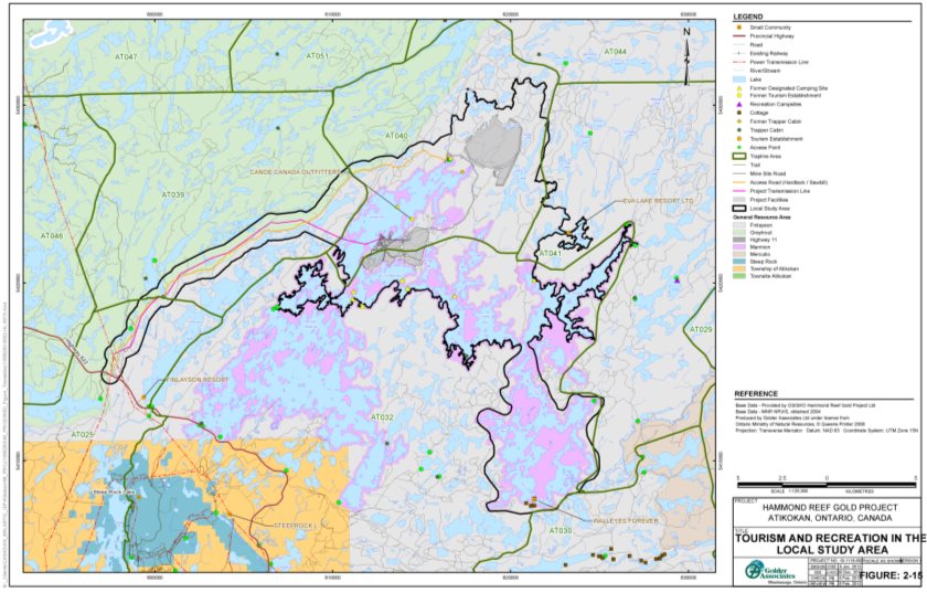
Source: Hammond Reef Gold Project Environmental Impact Statement/EA Report, Golder Associates
Effects and Mitigation
The proponent predicted that opportunities for outdoor recreation and tourism in the local study area would remain despite changes to resource availability, access restrictions, and sensory disturbance due to the Project. As described in earlier sections of this report, the proponent indicated that the Project would have negligible to low effects on water resources (Section 7.3), as well as fish and fish habitat (Section 7.4). As such, the proponent indicated that resources available for fishing in the local study area would experience negligible to low change. Section 7.5 indicates that terrestrial wildlife would be displaced to other parts of the socio-economic local study area. This displacement would lower the abundance of wildlife in the vicinity of the Project and redistribute wildlife to other areas where suitable habitats exist. The proponent also indicated that the area no longer available for hunting due to the project site (2327 hectares) is small compared to the size of the local study area (785 400 hectares). However, trapping opportunities for the two licence holders whose trapline areas (AT032 and AT040) intersect the mine study area would decline due to land area losses. To address the decline in trapping opportunities due to the reduction in the size of their trapline areas, the proponent committed to enter into compensatory agreements with the affected licence holders (Box 6-1). The proponent indicated that trapping opportunities in the other two trapline areas would not change as those areas are already affected by the existing road. Therefore, the proponent is of the view that changes to availability of local resources for fishing, hunting, and trapping would not adversely affect opportunities for these activities within the local study area.
The proponent also suggested that increased pressures on resources due to fishing and hunting by the project workforce would not affect the practice of those activities within the local study area, as the increased workforce would reverse the declining population trend in the area and the increased level of activity would be comparable to that in the past. The expected increase in the local population due to the maximum project workforce (1200 persons) would be less than the population decline in Atikokan between 1996 and 2011 (decline of 1256 persons).Footnote 27 Therefore, the proponent predicted that the maximum project workforce, assuming 100 percent of the workforce are anglers and hunters from outside the local study area, would cause a negligible change in fishing and hunting pressure relative to baseline. The proponent also indicated that the Ontario Ministry of Natural Resources and Forestry sets harvesting quotas independently of the number of hunting applicants, in order to manage overall resource levels. The proponent anticipated that a corporate policy to address safety and security concerns would also restrict fishing and hunting by on-site employees to address concerns about resources in the vicinity of the Project (Box 6-1). Given this understanding of the effects, the proponent concluded that changes in overall resource availability due to the Project would be negligible.
Regarding access restrictions, the proponent identified one baitfish harvester who would lose opportunities to harvest within the project site. The proponent committed to establish a compensatory agreement with the baitfish harvester to address revenue changes due to the Project (Box 6-1). Angling and baitfish harvesting in general along the eastern shores of Upper Marmion Reservoir would be prohibited due to safety and security concerns. However, opportunities would remain at other access points such as those along Lower Marmion Reservoir that are used by local residents, visitors and tourism operators (Figure 9).
Sensory disturbance linked to decreased air quality, elevated noise levels and altered viewscape would degrade the quality of experience. Changes to air quality and noise levels, as described in Section 7.2, would occur near the project site (primarily within two to three kilometres of the mine study area). The proposed mitigation measures to reduce human health risk from exposure to air contaminants and noise (Section 7.6) would displace land users to other parts of the local study area, where air quality and noise levels represent near baseline and baseline conditions. Further, the proponent indicated that the view of the waste rock stockpile (130 metres high) and the tailings mound (60 metres high) would affect the enjoyment of surroundings by campers and guide outfitters that seek isolated wilderness experiences. No specific mitigation measures were identified by the proponent to address sensory disturbance on recreational activities, such as camping and fishing, given there are numerous other sites available within the local study area which would not experience sensory disturbances from the Project. However, the altered viewscape would be partially mitigated upon project decommissioning with site rehabilitation, including removal of project buildings and revegetation of the tailings mound and other cleared terrain within the project site. To address any reduction in revenue of the only tourism establishment within one kilometre of the project site, the proponent committed to establish a compensatory agreement with the operator. Further to support tourism operators, the proponent would establish local sponsorships to promote the recreation and tourism industry, including community events such as the annual Atikokan Bass Classic fishing competition, to offset any potential decline in local tourism as a result of the Project (Box 6-1). The proponent also indicated that the compensatory agreements with the baitfish harvester and trapline licence holders would include the effects from sensory disturbance.
7.7.1.2 Views Expressed
Comments from the Ontario Ministry of Natural Resources and Forestry, the Ontario Ministry of Tourism, Culture and Sport, and the public on effects to outdoor recreation and tourism were addressed in the proponent's assessment.
7.7.1.3 Agency Analysis and Conclusion
Outdoor recreation and tourism activities in close proximity to the project site would decrease due to changes in resource availability, access restrictions, and sensory disturbance. Tourists and guide outfitters would be displaced. However the Agency is of the view that opportunities for recreation and tourism activities within the socio-economic local study area would remain, since impacts on resources would be confined to areas within two to three kilometres of the project site. The Agency also notes there are other locations within the local study area (and away from the project site) that would remain accessible and appropriate for outdoor recreation and tourism activities. Further, the proponent proposed mitigation measures to address revenue impacts on local tourism (Box 6-1).
Given the definitions of the environmental effects rating criteria in Appendix D, the magnitude and geographic extent of effects on outdoor recreation and tourism due the Project are rated as moderate as the level of activity by tourists and guide outfitters would decline in the local study area. Since the effects due to altered viewscape would occur during all project phases, while decreased air quality and elevated noise levels would cease during the decommissioning phase, the duration is rated as high. The frequency is also rated as high since changes in the way activities would be conducted (for example changes in locations and timing) would be continuous until the abandonment phase of the Project. Rehabilitation of the project site, which would begin after the operation phase, would partially reverse the effects on land use, including access and sensory disturbance.
Taking into account the proposed mitigation measures, the Agency concludes the Project is not likely to cause significant adverse effects on outdoor recreation and tourism.
7.7.2 Forestry activities
7.7.2.1 Proponent's Assessment
Existing Environment
Forestry activities occur within forest management units established in accordance with Ontario's Crown Forest Sustainability Act. The proponent indicated that the Project would intersect two units: Crossroute and Sapawe Forest Management Units, which are comprised of 838 121 hectares and 200 000 hectares of provincial Crown forest, respectively. Each unit is under the care of a sustainable forest licence holder. Resolute Forest Products Canada Inc. holds the licence for Crossroute Forest Management Unit. Rainy Lake Tribal Resource Management Inc., an Indigenous business, holds the licence for Sapawe Forest Management Unit.Footnote 28 These licence holders are responsible for implementing forest management plans that are approved by the Ontario Ministry of Natural Resources and Forestry and are designed to maintain and monitor forest functions, such as timber and commercial products, as well as wildlife habitat and recreational opportunities.
Effects and Mitigation
The proponent concluded that residual effects on forestry activities would be negligible, after the implementation of mitigation measures (Box 6-1) to compensate sustainable forest licence holders. The Project would overprint 2327 hectares within Crossroute Forest Management Unit and Sapawe Forest Management Unit, which is approximately a 0.2 percent loss of the total Crown forest within the management units. (The actual percentage lost would be less, given the entire project site is not forested land.) Timber from these forested areas and access to the timber would be lost during the construction and operation phases of the Project. Future mature timber stands would also be lost until access is restored. The proponent committed to mitigate these effects by establishing compensatory agreements with the sustainable forest licence holders to address changes in revenues from lost timber stands (Box 6-1).
7.7.2.2 Views Expressed
No comments were raised on effects to forestry activities.
7.7.2.3 Agency Analysis and Conclusion
Project effects would alter but not eliminate opportunities to continue forestry activities in the socio-economic local study area over the life of the Project. The proponent would compensate the sustainable forest licence holders that would lose merchantable timber within the project site (Box 6-1). The Agency is also aware that areas to be cleared for the Project would be incorporated in the relevant forest management plans, in accordance with Ontario's Crown Forest Sustainability Act, its regulations and guides. The Ontario Ministry of Natural Resources and Forestry confirmed that a forest management plan includes areas within the forest management unit set aside as contingency harvest areas to be used for harvest if eligible areas are unavailable. Further, the Ontario Ministry of Natural Resources and Forestry advised the Agency that the expected change in forest cover could be managed without adversely affecting harvesting, given the current level of forestry activity in the local study area. The Agency also notes that the proponent would revegetate using native vegetative species during site rehabilitation (Box 4-1 in Section 7.5), however the revegetation would not restore the forest cover for harvesting.
Considering the definitions of the environmental effects rating criteria (Appendix D), the magnitude of the effects on forestry activities is rated as moderate since the measurable loss in merchantable timber would not prevent forestry operations from continuing sustainably. The lost timber would occur within the project site. Therefore, the effect rating for geographic extent is low. The rating for duration is high as the effects would occur during all project phases. Since the changes in activities would be considered continuous, the effect rating for frequency is high. The effects would be irreversible as the site rehabilitation during the decommissioning phase would not revegetate with tree species that could contribute to future harvesting opportunities.
Taking into account the implementation of mitigation measures, the Agency concludes that the Project is not likely to cause significant adverse effects on forestry activities.
7.7.3 Hydropower production
7.7.3.1 Proponent's Assessment
Existing Environment
Hydropower producers along the Seine River control flows through the Raft Lake Dam at Upper Marmion Reservoir to generate higher flows during peak demand periods and reduced flows during off-peak periods. Reservoirs and dams along the Seine River are operated to comply with the Seine River Water Management Plan. This plan regulates water flows and levels to sustain water uses and protect natural resources. The Ontario Ministry of Natural Resources and Forestry enforces the compliance limits established under the plan. The ministry, along with the hydropower producers, are signatories to the plan and control the dams along the Seine River.
Effects and Mitigation
The proponent concluded the Project would not prevent hydropower production if hydropower producers work with the Project to manage the timing of water taking from Upper Marmion Reservoir. Water resources could sustain both the Project and hydropower production as only small changes in water flows and levels within the reservoir would occur due to the Project, given the proposed mitigation described in Box 2-1 of Section 7.3. However the proponent acknowledged that information sharing about water taking activities, including duration and timing, by the Project and hydropower facilities would be required to ensure resource availability, particularly during low flow periods. Therefore, the proponent committed to establish agreements with the hydropower producers to share water taking information and set conditions to address potential low flow scenarios at Raft Lake Dam (Box 6-1).
7.7.3.2 Views Expressed
Brookfield Renewable Power and H2O Power Limited Partnership indicated that as signatories to the Seine River Water Management Plan, they are subject to water flow and level compliance limits set within the plan by the Ontario Ministry of Natural Resources and Forestry and therefore are at risk of being non-compliant with the plan due to the Project. The proponent submitted water modeling to the Ontario Ministry of the Environment, Conservation and Parks for review. The ministry concluded there is sufficient water in the system to accommodate the additional demand created by the Project. The Ontario Ministry of the Environment, Conservation and Parks further advised that if the Project is approved, then conditions for the Permit to Take Water would be discussed with the Ontario Ministry of Natural Resources and Forestry to avoid conflict with the Seine River Management Plan. Further, the proponent committed to share its water-taking information with the Ontario Ministry of Natural Resources and Forestry to monitor the Project's influence on the hydropower producers adhering to the compliance limits (Box 6-1).
7.7.3.3 Agency Analysis and Conclusion
Water taking by the Project, primarily during the construction and operation phases, could have adverse effects on operational activities of the hydropower producers who are signatories to the Seine River Water Management Plan. Avoiding effects on hydropower production would be contingent on water being available when required by the hydropower facilities. The Agency notes that the proponent has identified mitigation measures (Box 2-1 in Section 7.3) to avoid measurable decreases in water flows and levels due to the Project. The Ontario Ministry of the Environment, Conservation and Parks, pursuant to the Ontario Water Resources Act, would outline conditions in consultation with the Ontario Ministry of Natural Resources and Forestry to govern water taking by the Project. The conditions would take into account the requirements of the Seine River Water Management Plan. The Agency further notes the implications of non-compliance to hydropower producers, but is of the view that the Ontario Ministry of Natural Resources and Forestry would monitor water flows and levels to pro-actively manage the risk of non-compliance with the Seine River Water Management Plan.
Given this understanding of the effects and considering the definitions of the environmental effects rating criteria in Appendix D, the magnitude of effects on hydropower production is rated as moderate since the changes in water flows and levels due to water taking by the Project would require alteration in behaviour (specifically, coordinating water taking activities) to continue current hydropower production. The geographic extent and duration are rated as moderate since the effects would occur within the local study area and would occur primarily during the construction and operation phases. The effects on hydropower production would be intermittent since production would be at risk whenever water flows and levels were near the compliance limits set by the Seine River Water Management Plan. As such, the effects rating for frequency is moderate. The effects would be reversible, as water taking by the Project would cease at the abandonment phase.
Taking into account the implementation of mitigation measures (Box 6-1), the Agency concludes the Project is not likely to cause significant environmental effects on hydropower production.
Box 6-1: Key mitigation measures to address effects on socio-economic conditions
Mitigation Measures for Outdoor Recreation and Tourism
- Establish compensatory agreements with the baitfish harvester, trapline licence holders of areas AT032 and AT040, and the tourism establishment within one kilometre of the project site prior to the construction phase to address revenue changes due to the Project.
- Develop and implement a corporate policy that restricts fishing and hunting by on-site employees during the construction and operation phases to address concerns about increased pressures on resources.
- Establish sponsorships to promote the local recreation and tourism industry, including community events such as the annual Atikokan Bass Classic, during the construction and operation phases, as a means to offset any negative perception due to the Project.
- See mitigation measures to address effects on air quality and noise (Box 1-1 of Section 7.2), water resources (Box 2-1 of Section 7.3), fish and fish habitat (Box 3-1 of Section 7.4), and terrestrial habitats and wildlife (Box 4-1 of Section 7.5).
Mitigation Measures for Forestry Activities
- Establish compensatory agreements with sustainable forest licence holders prior to the construction phase to address revenue changes due to the Project, including the removal of merchantable timber to accommodate the Project and lost forested areas within the project site.
Mitigation Measures for Hydropower Production
- Establish agreements with hydropower producers prior to the construction phase to share water taking information and set conditions to address potential low flow scenarios at Raft Lake Dam.
- Share water flow and level information with the Ontario Ministry of Natural Resources and Forestry during the construction, operation and decommissioning phases to support the Seine River Water Management Plan.
- See mitigation measures to reduce changes in water flows and levels in Box 2-1 of Section 7.3.
7.8 Current Use of Lands and Resources for Traditional Purposes by Aboriginal Persons
The Agency is of the view that the Project is not likely to cause significant adverse effects on the current use of lands and resources for traditional purposes by Aboriginal persons, after taking into account the proposed key mitigation measures (Box 7-1) to address changes in resource availability, area access and changes in the quality of experience. The Agency's conclusions are based on its analysis of the proponent's assessments and the views expressed by Indigenous groups.
7.8.1 Changes in the quality and availability of resources and access to lands and resources
7.8.1.1 Proponent's Assessment
Existing Environment
The Project would be located within the Treaty 3 territory and the traditional harvesting area of the Métis Nation of Ontario Treaty 3/ Lake of Woods/ Lac Seul/ Rainy Lake-Rainy River Regional Consultation Protocol. Seine River First Nation, Lac des Mille Lacs First Nation, Lac La Croix First Nation, and the Métis Nation of Ontario are closest to the Project (within 100 kilometres). Indigenous groups listed in Subsection 2.2.1 use the regional study area for traditional activities such as fishing, hunting, plant harvesting and trapping.
The Indigenous groups are known to fish in the local study area, specifically, Lac des Mille Lacs First Nation, Seine River First Nation, and Mitaanjigamiing First Nation noted that their community members fish in the area. Fishing primarily occurs in Upper Marmion Reservoir and Lizard Lake. Species fished include Walleye, Northern Pike, and Smallmouth Bass. Baitfish are also caught in the area. The proponent indicated that fishing occurs throughout the year. According to the proponent's traditional land use study, hunting occurs opportunistically while setting traps or fishing, and typically happens during the daytime in close proximity to existing roads. All Indigenous groups consulted for the Project are known to hunt in the regional study area; however, no preferred hunting sites were identified. Hunting primarily occurs on a daily basis in the regional study area during the peak hunting season between September 15 and November 15. Wildlife hunted include deer, moose, rabbit, partridge and duck.
The proponent reported that the Indigenous groups harvest plants for traditional purposes in the regional study area and beyond and that no site-specific harvesting areas have been identified in the local study area. Forest and wetland within the regional and local study areas include habitat that supports traditional land use plants such as Eastern White Cedar, White Spruce, Black Spruce, blueberries, and Labrador Tea. Wild rice is harvested outside of the regional study area by Seine River First Nation and Wabigoon Lake Ojibway Nation. No wild rice harvesting areas were identified in Upper Marmion Reservoir or Lizard Lake.
Trapline area AT040, licensed to a member of the Seine River First Nation, overlaps the mine study area and parts of the regional and local study areas, where habitats exist for furbearers such as beaver, muskrat and marten. The trapline area includes a cabin that is located immediately southwest of the proposed tailings management facility (Figure 9). The proponent noted that the trapline licence holder visits area AT040 about 21 times per year (during the fall and winter trapping season), with overnight stays twice a year. A member of Lac des Mille Lacs First Nation holds trapline area AT041, which would not lose land as a result of the Project. On average, the trapper uses area AT041 at the same frequency of the trapline licence holder of trapline area AT040, with the exception of no overnight stays.
Indigenous groups access the regional and local study areas for traditional purposes, by truck and all-terrain vehicle using Premier Lake Road or by boat or canoe via Marmion Reservoir and Lizard Lake.
Effects and Mitigation
The proponent predicted that current Indigenous uses would not be affected by project-related changes to the quality and availability of resources or access to lands and resources, after the implementation of mitigation measures (Box 7-1). The proponent indicated that the quality of terrestrial wildlife and vegetation would not be affected by the Project due to predicted changes in metal concentrations in surface water and soil. In addition, the Project would not change the quality of fish from baseline conditions. However, given the importance of the quality of fish to Indigenous groups, the proponent committed to monitor mercury in fish and share the monitoring results with the Ontario Ministry of Environment and Climate Change to update the fish consumption guide (Subsection 7.6.3). As noted in Section 7.7, there would be no measureable change to resources available for fishing in the local study area throughout the year. Wildlife hunted and trapped would be displaced from the mine study area due to construction of the mine site. Wildlife would move to similar habitats in the local study area and may return to the area after acclimatizing to the elevated noise levels (Section 7.5.1). Hunting opportunities would not be affected as the Project would not reduce the overall availability of wildlife in the local study area (Section 7.7). Therefore, the proponent does not expect adverse effects from changes in quality or availability of resources that support fishing and hunting.
The proponent predicted the Project would result in the direct loss of less than one percent of forested areas and approximately 0.03 percent of wetlands that contain suitable habitat for traditional land use plants in the regional study area. There are no known plant harvesting sites in the local study area. Thus the direct loss of forested and wetland areas in the local study area is not expected to affect plant harvesting activities.
As noted above, the quality of terrestrial wildlife would not be affected by the Project. Thus the proponent does not expect this to have an adverse effect on trapping. However, trapping opportunities in trapline area AT040 could decline as a portion of land would be lost due to the Project. The proponent has an agreement with the trapline licence holder to address the decline in trapping opportunities. The agreement includes financial compensation, employment opportunities, and relocation of the trapper cabin, if required. Therefore, the proponent does not expect adverse effects from changes in availability of resources on trapping.
Access to the project site would be restricted for safety and security reasons. Access to existing fishing locations would not be impacted and access to hunting locations could improve with the proposed upgrade of the access road. The proponent's agreement with the trapline licence holder of area AT040 grants access to the project site for trapping, provided that the trapline licence holder is accompanied by an authorized proponent representative. After decommissioning, the trapline licence holder would have access restored to the majority of the trapline area, with the understanding that the waste rock stockpile and tailings mound in the tailings management facility would remain in situ. Therefore, the proponent does not expect adverse effects from changes to access.
7.8.1.2 Views Expressed
Comments were raised by Couchiching First Nation, Lac La Croix First Nation, Métis Nation of Ontario, Mitaanjigamiing First Nation, Seine River First Nation, and Rainy River First Nations about potential impacts to resource quality (wildlife health and availability) for traditional purposes by Indigenous groups early in the environmental assessment process. These were addressed in the proponent's assessment, in Sections 7.3 to 7.6, and are summarized in Appendix A.
Lac des Mille Lacs First Nation, Métis Nation of Ontario and Seine River First Nation commented on changes in access to lands and resources and how that would infringe on their rights to use the land for traditional purposes. This comment is addressed in Chapter 9 and summarized in Appendix A.
Lac des Mille Lacs First Nation, Nigigoonsiminikaaning First Nation and Seine River First Nation commented that gold market conditions raised uncertainty about whether information gathered during the environmental assessment process in relation to traditional uses of lands and resources in the local study area would become outdated. The proponent acknowledged the uncertainty due to changing market conditions influence project scheduling and indicated that the resource sharing committees as described in Subsection 2.2.2 would be used to discuss any concerns about new or updated land and resource use information. In addition, the proponent committed to meet with the environmental committee on a quarterly basis, as practicable for the committee members, to address concerns and matters of interest, including environmental monitoring and involvement of the First Nations in monitoring programs.
7.8.1.3 Agency Analysis and Conclusion
The Agency concludes that the Project would result in negligible to low effects on fishing, hunting and plant harvesting due to changes in the quality and availability of resources and access to lands and resources. Indigenous groups expressed concerns about resources being potentially contaminated by the Project. The quality of fish, terrestrial wildlife and vegetation are not predicted to be affected by the Project. No preferred hunting and plant harvesting locations were identified in the local study area, so any changes in the availability of resources in the local study area are not expected to affect the practice of these traditional activities. The Agency also notes that the proposed upgrade to the access road may improve access to opportunistic hunting along the road. Access to fishing locations along the eastern shoreline of Upper Marmion Reservoir would be prohibited due to safety concerns (Section 7.7). However, other access points for fishing locations would remain open. Access to plant harvesting sites would not be affected by the Project.
The Agency is of the view that the Project would cause effects to trapping activities from changes in the availability of resources and access to lands and resources. The Agency notes that the proponent reached an agreement with the trapline licence holder to compensate for the loss of trapline area AT040 due to the Project, the reduced opportunities to trap in the area, and to provide access to the project site and undisturbed portions of the trapline area. Further, trapping could continue in other parts of the trapline area.
First Nations expressed concern that information gathered about land and resource uses in the local study area has become outdated over the course of the assessment. The proponent has committed to work with the resource sharing committees throughout the project phases to address community concerns with the Project (Subsection 2.2.2 of this report). Of particular note, the proponent committed to engage the First Nations in environmental monitoring for the Project. The proponent made a similar commitment to work on an ongoing basis with the consultation committee established with the Métis Nation of Ontario to address concerns and interests, including environmental monitoring. Through these committees, the proponent would be able to address issues that may arise from changes in information after the environmental assessment, should the Project proceed.
Given the proposed mitigation measures and considering the definitions of the environmental effects rating criteria in Appendix D, the magnitude of the effect on trapping as a result of changes in availability of resources and access to lands and resources is rated as low as the agreement between the proponent and the trapline licence holder would address these effects and trapping may continue in other parts of the trapline area. The quality of resources for trapping is not predicted to be affected (Subsection 7.6.3). The geographic extent is rated as moderate since wildlife available for trapping would be displaced into the local study area from the mine study area. Effects on trapping would occur during construction, operation and decommissioning as wildlife habitat would be lost or altered until the project site is rehabilitated; as a result, the effects rating for duration is rated as high. The frequency effects rating is low as the trapline licence holder is known to visit the trapline area approximately 21 days per year and would be able to trap in other parts of the trapline area. After decommissioning, effects on trapping are predicted to be partially reversible with the rehabilitation of the project site but the waste rock stockpile and the tailings mound in the tailings management facility would remain unavailable for trapping.
Taking into account the implementation of mitigation measures (Box 7-1), the Agency concludes the Project is not likely to cause significant adverse effects on fishing, hunting, plant harvesting and trapping.
7.8.2 Changes in the quality of experience from sensory disturbances
7.8.2.1 Proponent's Assessment
Effects and Mitigation
The proponent predicted negligible residual effects on hunting and plant harvesting from diminished quality of experience due to sensory disturbances, specifically, decreased air quality, elevated noise levels and changes in the visual landscape from project components. As stated in Section 7.2, decreased air quality and elevated noise levels would occur within two to three kilometres of the mine study area. As traditional plant harvesting is practiced outside the local study area, the proponent does not expect changes in the quality of experience. In addition, opportunistic hunting in the local study area occurs mainly along the existing roads so the proposed upgrade of the access road may improve the quality of experience for hunting.
The proponent predicted negligible residual effects on fishing in Upper Marmion Reservoir and trapping in area AT040 from diminished quality of experience due to sensory disturbances. The proponent predicted that decreased air quality and elevated noise levels would occur over one of the many waterbodies used for fishing (namely Sawbill Bay) and in a small portion of the trapline area, thus the changes to fishing and trapping experiences would be limited. The proponent committed to address sensory disturbances through measures to control air emissions and reduce noise levels (described in Box 1-1 in Section 7.2) as well as notifying Indigenous groups of potential decreased air quality, addressing air quality and noise complaints, and posting signs to alert land users of decreased air quality and elevated noise levels (described in Box 5-1 in Section 7.6).
The proponent also predicted low residual effects on trapping in trapline area AT040 and fishing in Upper Marmion Reservoir and Lizard Lake from the progressive change in the viewscape due to the construction and operation of the Project. During decommissioning, the viewscape would improve as the site would be progressively rehabilitated. The tailings mound in the tailings management facility would be revegetated to blend in with the surrounding area with only the non-vegetated waste rock stockpile remaining in the landscape after decommissioning. In the event that land use concerns arise related to the altered viewscape, the proponent committed to address these issues through existing First Nations resource sharing committees and the consultation committee with the Métis Nation of Ontario as described in Subsection 2.2.2.
7.8.2.2 Views Expressed
Lac des Mille Lacs First Nation, Mitaanjigamiing First Nation, Métis Nation of Ontario and Seine River First Nation provided comments on changes in the quality of experience of traditional land use activities from sensory disturbances, which are described in the proponent's assessment above and summarized in Appendix A.
7.8.2.3 Agency Analysis and Conclusion
The Agency agrees that the quality of hunting and plant harvesting experiences would not be affected by sensory disturbances. However, the Agency is of the view that fishing and trapping experiences could be diminished due to decreased air quality and elevated noise levels during the construction and operation phases and an altered viewscape during all project phases. Indigenous groups fishing in Upper Marmion Reservoir, specifically in Sawbill Bay, would experience elevated noise levels and an altered viewscape which may result in choosing other fishing locations in the local study area. The proponent proposed mitigation measures to reduce elevated noise levels and committed to address any land use concerns through existing Indigenous committees. Despite these measures, the quality of fishing experience in Sawbill Bay could change due to sensory disturbances. Trapping experience could also be diminished from sensory disturbances; however, the proponent's agreement with the trapline licence holder would address these effects. The Agency notes that it is difficult to predict the degree to which the effects may diminish the quality of fishing and trapping experiences due to its subjective nature. While the quality of fishing and trapping experiences could worsen due to sensory disturbances within two to three kilometres of the mine study area, the Agency is of the view that fishing and trapping could continue in other parts of the local study area without sensory disturbance.
Given the proposed mitigation measures and considering the definitions of the environmental effects rating criteria in Appendix D, the magnitude of effects on fishing and trapping is rated as moderate as sensory disturbances could diminish the quality of experience but not prevent these activities from taking place. The geographic extent is rated as moderate as the effects would occur in the local study area. While the effects from decreased air quality and elevated noise levels would occur primarily during the construction and operation phases, the effects from the altered viewscape would continue to occur after the decommissioning phase. Therefore, the duration is rated as high. The frequency is also rated as high as the effects from elevated noise levels and the altered viewscape would occur on a daily basis with the effects from decreased air quality occurring intermittently. The effects are partially reversible as decreased air quality and elevated noise levels would end after project activities cease, while the waste rock stockpile and tailings mound in the tailings management facility would continue to alter the viewscape after decommissioning.
Taking into account the implementation of mitigation measures, the Agency concludes the Project is not likely to cause changes to the environment that would cause significant adverse effects on the quality of experiences associated with current use of lands and resources for traditional purposes by Aboriginal persons.
Box 7-1: Key mitigation measures to address effects on current use of lands and resources for traditional purposes by Aboriginal persons
Mitigation Measure to Address Effects on Current Use of Lands and Resources for Traditional Purposes by Aboriginal Persons from Changes in Availability of Resources and Access to Lands and Resources
- Grant continued access to trapline area AT040 during construction, operation and decommissioning phases as per the agreement in place with the trapline licence holder. The agreement also includes financial compensation, employment opportunities and relocation of the trapper cabin if required.
- See mitigation measures to address effects on noise (Box 1-1 of Section 7.2), water resources (Box 2-1 of Section 7.3), fish and fish habitat (Box 3-1 of Section 7.4), and terrestrial habitats and wildlife (Box 4-1 of Section 7.5).
Mitigation Measure to Address Effects on Current Use of Lands and Resources for Traditional Purposes by Aboriginal Persons from Changes in the Quality of Experience from Sensory Disturbances
- See the mitigation measures to control air emissions and reduce noise levels in Box 1-1 of Section 7.2.
7.9 Physical and Cultural Heritage Resources
The Agency is of the view, after taking into account implementation of the proposed key mitigation measures (Box 8-1), the Project is not likely to cause a significant adverse effect on the heritage value of the historic Hammond Reef Mine and Sawbill Mine sites. The Agency's conclusion is based on its analysis of the proponent's assessment and views expressed by the Ontario Ministry of Tourism, Culture and Sport, as well as Indigenous groups.
7.9.1 Former Hammond Reef Mine and Sawbill Mine Sites
7.9.1.1 Proponent's Assessment
Existing Environment
The proponent indicated that archaeological field surveys within the mine study area and discussions with Indigenous groups did not identify any physical or cultural heritage resources of Indigenous importance within the project site. The surveys did identify ruins of the former Hammond Reef Mine and Sawbill Mine sites (shown in Figure 10). These sites are not easily accessible by the public. Remnants of the former Hammond Reef Mine site include: mine adits, pulleys, a concrete machinery base, a timber dam, and an abandoned log cabin with remains of a large cast-iron stove. The Sawbill Mine site remnants include mine shafts, a stamp mill foundation, a pulley block, rock cuts, a small steam engine and an intact Imperial Keighley engine.
The proponent's site evaluations, completed in accordance with Ontario regulations O.Reg. 9/06: Criteria for Determining Cultural Heritage Value or Interest and O.Reg. 10/06: Criteria for Determining Cultural Heritage Value or Interest of Provincial Significance pursuant to Ontario Heritage Act, concluded the site remnants are not rare or unique. The integrity of the heritage landscape has been compromised by subsequent exploration, demolition and removals, as well as vegetation regrowth. However, the proponent determined that the former Hammond Reef Mine and Sawbill Mine sites, with their remnants, have local historic value and represent an industry cultural landscape typical of small scale mining operations during the early 20th century gold mining era in Northwestern Ontario. The heritage value of these sites is based on the historic ties to the local community as well as the physical, functional, historic and visual links between the site remnants and the surrounding environment.
Figure 10: Locations of the two historic mine sites in the mine study area 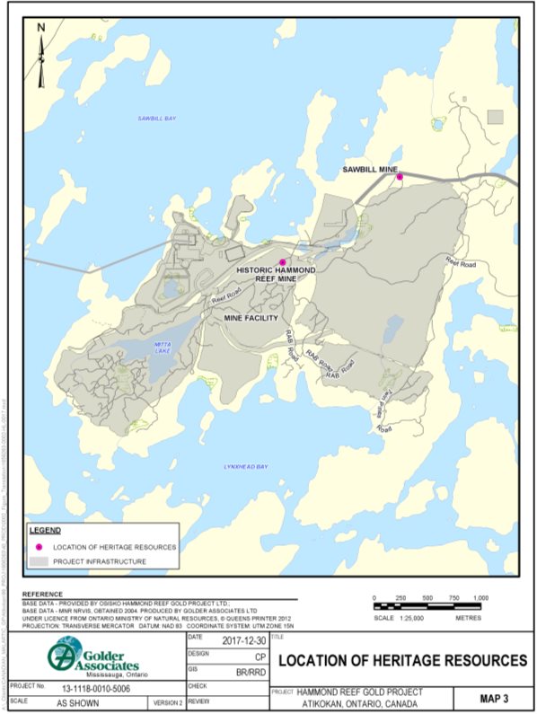
Source: Hammond Reef Gold Project Environmental Impact Statement/EA Report, Golder Associates
Effects and Mitigation
The proponent predicted the Project would have a residual effect due to disturbance, loss or relocation of remnants from the former Hammond Reef Mine and Sawbill Mine sites, after implementation of mitigation measures (Box 8-1). Specifically, as part of site clearing and excavation activities to construct the east pit and associated infrastructure, the former Hammond Reef Mine would have to be removed. Remnants of Sawbill Mine may also be damaged or destroyed to develop linear infrastructure and the waste rock stockpile. To compensate for these irreversible effects, the proponent committed to a historical documentation program, submitting photo and map records of all heritage features at both sites to the Atikokan Museum for easy access by the local community. Heritage features that remain on-site would be monitored by the proponent and action would be taken to preserve their condition, in accordance with a conservation plan to be approved by the Ontario Ministry of Tourism, Culture and Sport.
The proponent acknowledged the potential for additional archaeological discoveries during project construction. If discoveries are made, the proponent committed to cease work and follow protocols for new archaeological discoveries pursuant to the Ontario Heritage Act.
7.9.1.2 Views Expressed
The Ontario Ministry of Tourism, Culture and Sport indicated archaeological monitoring during the draining of Mitta Lake should occur, in the event the Project proceeds. The proponent responded that both the area around Mitta Lake, which was surveyed and documented as steeply sloped, and the area under Mitta Lake are not likely to have archaeological potential. Nonetheless, remote archaeological monitoring would occur, consisting of a scheduled review of photo documentation taken by on-site staff to determine whether closer examination is required. The proponent committed to cease work and engage a licensed consultant archaeologist to conduct fieldwork in accordance with the Ontario Heritage Act, if archaeological resources are discovered in the mine study area during construction.
Rainy River First Nations commented that there should be a formal protocol for new discoveries of Indigenous heritage resources. The proponent responded that new discoveries would be subject to the requirements of the Ontario Heritage Act, all project work would cease, and Indigenous groups would be contacted in accordance with the established protocols of the agreements between the Indigenous groups and the proponent.
7.9.1.3 Agency Analysis and Conclusion
The Project would have a residual effect on the heritage resource value due to disturbance, loss or relocation of remnants from the former Hammond Reef Mine and Sawbill Mine sites. The proponent's assessment, which has been accepted by the Ontario Ministry of Tourism, Culture and Sport, concluded that the sites have local (not provincial) heritage value due to their historical attributes. The assessment further indicates that the site remnants are not rare or unique. On the matter of the potential for additional archaeological discoveries, the Agency is satisfied that the proponent committed to follow protocols for new archaeological discoveries pursuant to the Ontario Heritage Act. The Agency further notes the proponent committed to follow established protocols with the Indigenous groups to address new discoveries of Indigenous heritage resources. The Agency is also aware that for such discoveries, the proponent would be subject to the requirements of the Ontario Ministry of Tourism, Culture and Sport and the Ontario Heritage Act.
While remnants on the former Hammond Reef Mine and Sawbill Mine sites would be altered, lost or removed during construction, the proponent's commitment to a photo documentation program would partially preserve the historical attributes and connections represented by the sites. Sharing this documentation program with the Atikokan Museum would provide an accessible historical record of these mine sites to area communities linked to historic mining activity that is currently difficult to achieve as the sites are not easily accessible. The Agency also notes the Ontario Ministry of Tourism, Culture and Sport would require a conservation plan to preserve heritage features that would remain on-site. However, remnants preserved on-site would not be publicly accessible due to restricted site access for safety and security concerns.
Given this understanding of the effects, as well as the definitions of the environmental effects rating criteria in Appendix D, the magnitude of the residual effect on the heritage resource value of the resources is rated as high since remnants from the former mine sites would be lost or removed from the surrounding natural environment. The geographic extent is rated as low as changes to the heritage resource value would affect local communities historically associated with the mine sites. The changes in heritage value would be permanent. Therefore, the duration and frequency are rated as high and the effect would be irreversible. The site remnants are not rare or unique, and currently both sites are not easily accessible. Further, the sites are degraded by past human activities and vegetative regrowth. The Agency is of the view that implementation of the proposed mitigation measures would support public access to salvaged remnants from the sites and preserve a local connection to these resources.
Taking into account the proposed mitigation measures (Box 8-1), the Agency concludes the Project is not likely to cause a significant effect on physical and cultural heritage resources.
Box 8-1: Key mitigation measures to address effects on physical and cultural heritage resources
Mitigation Measures to Preserve Heritage Resource Value
- Prepare a documentation program prior to the construction phase, including photo and map records of all heritage features located at both sites, and submit the program to the Atikokan Museum for easy access by the local community to partially preserve heritage integrity of affected sites.
- Remove the Imperial Keighley engine prior to the construction phase, restore the engine at an expert's facility in Alberta, and display it in the Atikokan Museum (through a virtual link) upon completion, along with other small artefacts collected from the mine sites, to partially compensate for loss of sites.
- Develop and implement a conservation plan that contains measures, including installation and periodic inspection of access barriers, prior to the construction phase, as required by the Ontario Ministry of Tourism, Culture and Sport, to protect heritage features that would not be removed from site.
- Cease work, in the instance of a new discovery, and follow protocols for new archaeological discoveries pursuant to the Ontario Heritage Act, during the construction phase.
- Establish a protocol with the Indigenous groups, prior to the construction phase, to identify the actions to be taken in the event an Indigenous artefact or heritage site is discovered.
8 Other Effects
8.1 Cumulative Environmental Effects
The Agency is of the view that the Project, in combination with past, present and reasonably foreseeable projects, is not likely to cause significant adverse cumulative environmental effects and that no additional mitigation or follow-up program measures are required. In making this determination, the Agency considered the project effects, (specifically on the following valued components: atmospheric environment (specifically air quality), water resources, fish and fish habitat, and terrestrial habitats and wildlife), views expressed by federal departments, provincial ministries, Indigenous groups and the public, and the proposed mitigation measures (Chapter 7), as well as the effects of other projects and the existing federal and provincial regulatory regimes.
8.1.1 Approach and scope
The proponent identified past, existing, and reasonably foreseeable projects that could interact with the Project. Industrial and resource-related projects were considered, including closed and reasonably foreseeable metal mines, as well as existing electrical generation and forestry operations. Their potential environmental effect interactions with the Project are listed in Table 15. Figure 11 shows their locations in relation to the Project. The proponent assessed how project effects could overlap, taking into account the geographic extent, duration and timing of the effects. The proponent's assessment also considered existing regulatory regimes that influence how projects are managed.
|
Past, Existing and Future ProjectsFootnote 29 |
Potential Interaction with the Project |
|---|---|
|
Atiko-Sapawe Gold Mine |
|
|
Steep Rock Iron Mine |
|
|
Atikokan Generating Station |
|
|
Resolute Forest Products Sawmill |
|
|
Rainy River Gold Project Josephine Cone Iron Mine Project Goliath Gold Project |
|
Figure 11: Past, existing and future projects situated near the Hammond Reef Gold Project 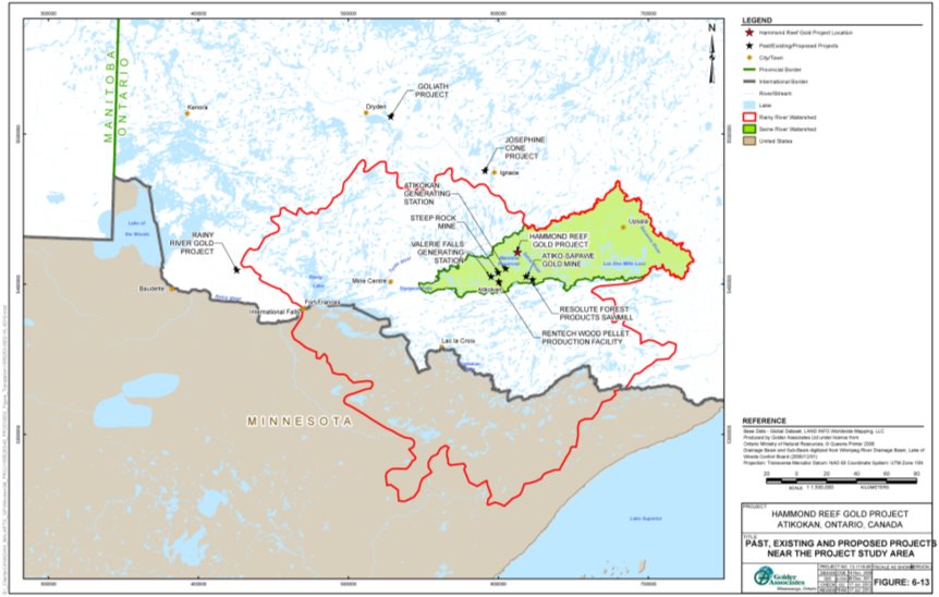
Source: Hammond Reef Gold Project Environmental Impact Statement/EA Report, Golder Associates
8.1.2 Air quality
8.1.2.1 Proponent's Assessment
The proponent does not anticipate interactions of air quality effects between the Project and the other projects listed in Table 15. The proponent's assessment concluded that changes in air quality due to the Project would be confined to an area within two kilometres around the project site under worst meteorological conditions (Subsection 7.2.1). Changes in air quality beyond the local study area that could interact with other air emission sources are not expected. In addition, the proponent indicated that the Project would require an Environmental Compliance Approval for air from the Ontario Ministry of the Environment, Conservation and Parks, pursuant to Ontario's Environmental Protection Act, to operate. That approval would set emission limits for the Project to protect local air quality. Further, the proponent indicated that the existing Atikokan Generating Station, Resolute Forest Products Sawmill and Rentech Wood Pellet Production Facility, as well as the proposed mining projects are located outside the local study area of the Project. Therefore no interaction of air quality effects between the projects is expected.
8.1.2.2 Agency Analysis and Conclusion
The Agency is of the view that distances between projects limit the potential for cumulative effects on air quality. The proponent's air quality modeling predicted concentrations of particulate matter (TSP, PM10 and PM2.5) and combustion products other than greenhouse gases (acrolein and sulphur dioxide) that exceed air quality criteria would occur within a tight area (approximately two kilometres) around the mine study area (Section 7.2). The other projects are located outside the local study area of the Project. Therefore, project-related emissions would not interact with those from other projects or activities and no further mitigation or follow-up program measures are required for the Project.
Taking into account the predicted residual effects and the proximity to other projects or activities, the Agency concluded the Project, in combination with existing and reasonably foreseeable projects or activities, is not likely to cause significant cumulative effects on air quality.
8.1.3 Water resources
8.1.3.1 Proponent's Assessment
The proponent predicted that the Project would not lead to cumulative environmental effects on water resources. The proponent indicated that projects along the Seine River downstream of Upper Marmion Reservoir would not be affected as predicted changes in water flows and levels in the reservoir due to the Project would be negligible to low (Section 7.3). The Atikokan Generating Station would not affect water levels in Upper Marmion Reservoir as the station uses water from Lower Marmion Reservoir for cooling purposes and returns it to that reservoir. Therefore the proponent concluded that water flow and level effects of the Project and those effects from other projects would not interact.
Regarding water quality, the proponent predicted that the water quality conditions at the outflow of Upper Marmion Reservoir due to the Project would be protective of aquatic life and would not affect water quality conditions downstream as the discharges from the other projects enter the Seine River system. The proponent indicated that discharge effluent would comply with the Metal and Diamond Mining Effluent Regulations. Further, the water quality of Upper Marmion Reservoir, taking into consideration discharges by the Project, would meet the requirements of the Ontario Ministry of the Environment, Conservation and Parks during all project phases, pursuant to the Ontario Water Resources Act (Section 7.3.2). In addition, the proponent indicated that the former Atiko-Sapawe Gold Mine as well as the existing Resolute Forest Products Sawmill and Rentech Wood Pellet Production Facility are between 17 and 23 kilometres southeast of the project site and discharge their effluents into a different sub-watershed of the Seine River system, where water quality effects from the outflow of Upper Marmion Reservoir would be undetectable. The Rainy River Gold Project would discharge into the Rainy River system. The proposed Josephine Cone Project and Goliath Gold Project would discharge their effluents into different watersheds from the Project. Given the predicted project-related effects on water quality and the distances from the other projects, the proponent expects no interactions with water quality effects from those projects.
8.1.3.2 Views Expressed
Couchiching First Nation, Nigigoonsiminikaaning First Nation, Rainy River First Nations, and Seine River First Nation asked whether effluent from the Project along with the Steep Rock Mine overflow would affect water quality within the Seine River system. The proponent indicated that while some parameters, particularly copper and sulphate, may increase in concentration downstream of Upper Marmion Reservoir, overall water quality and aquatic life downstream of the Project would not be affected as the water quality within the local study area, and therefore flowing downstream, would comply with the Ontario Water Resources Act.
8.1.3.3 Agency Analysis and Conclusion
The Agency is of the view that the Project's contributions to cumulative effects on water flows and levels would be limited. The residual effects on water flows and levels due to the Project would be negligible to low (Section 7.3). Further, the Agency is aware that the Project would require a Permit to Take Water from the Ontario Ministry of the Environment, Conservation and Parks pursuant to the Ontario Water Resources Act, which would include conditions to avoid conflict with the compliance limits for water flows and levels, as outlined in the Seine River Water Management Plan. Given this provincial regulatory regime to maintain flows and levels, the Agency is of the view that no further mitigation or follow-up program measures are required for the Project.
The residual effects on water quality due to the Project would not interact with the other projects downstream. Effluent discharge from the Project would be required to comply with the Metal and Diamond Mining Effluent Regulations, as well as the Ontario Water Resources Act. Similarly, the proposed mining projects would also be subject to federal and provincial water quality requirements. The Ontario Ministry of the Environment, Conservation and Parks would manage the water quality of the overflow that is expected from the Steep Rock Mine site into the Seine River system (circa 2070) such that water quality would be protective of natural resources within the watershed. As a result, the Agency is of the view that water quality would be within provincial regulatory requirements and that no further mitigation or follow-up program measures are required for the Project.
Taking into account the predicted residual effects and absence of notably adverse interactions with other projects, the Agency concluded the Project, in combination with past, existing and reasonably foreseeable projects, is not likely to cause significant cumulative effects on water resources.
8.1.4 Fish and fish habitat
8.1.4.1 Proponent's Assessment
The proponent does not anticipate cumulative environmental effects on fish and fish habitat. The proponent predicted negligible residual effects from the Project after taking into account the mitigation measures to avoid and minimize impacts to fish populations and offset loss or alteration of fish habitat (Section 7.4). Any effects from other projects, specifically the proposed mining projects listed in Table 15, would occur in watersheds that are outside the local study area of the Project.
8.1.4.2 Agency Analysis and Conclusion
The Agency agrees that the predicted residual effects on fish and fish habitat due to the Project are low and localized (Section 7.4). Further, the reasonably foreseeable mining projects identified in Table 15 would not interact with the Project's effects on fish and fish habitat due to their distances from the Project and their locations in different watersheds. As a result, the Agency is satisfied that interactions with other projects to cause cumulative environmental effects on fish populations and habitats would not likely occur. Therefore, the Agency is of the view that no further mitigation or follow-up program measures are required for the Project.
Taking into account the predicted residual effects due to the Project and absence of notable interactions with effects from other projects, the Agency concluded the Project is not likely to cause significant cumulative effects on fish and fish habitat.
8.1.5 Terrestrial habitats and wildlife
8.1.5.1 Proponent's Assessment
The proponent concluded that the Project, in combination with past, existing and future projects, would not result in cumulative environmental effects on terrestrial habitats and wildlife. The proponent's assessment incorporated effects on terrestrial habitats and wildlife from past and existing projects in the baseline conditions of the Project. The assessment predicted that habitat loss due to the Project would displace terrestrial wildlife including species at risk to the local and regional study areas (Section 7.5). Therefore, the proponent indicated that the low physical and biological residual effects due to the Project beyond the local study area preclude any interaction of effects with future projects to cause cumulative effects.
8.1.5.2 Agency Analysis and Conclusion
The Agency agrees that contributions to cumulative environmental effects on terrestrial habitats and wildlife by the Project would involve the localized effects from the Project, as described in Section 7.5 of this report. Further, the distances from future projects would limit any potential interaction of effects; therefore, the Agency is of the view that no further mitigation or follow-up program measures are required for the Project.
Taking into account the predicted residual effects and the proximity to other projects or activities, the Agency concluded the Project, in combination with existing and reasonably foreseeable projects or activities, is not likely to cause significant cumulative effects on terrestrial habitats and wildlife.
8.2 Effects of Accidents and Malfunctions
8.2.1 Potential environmental effects and mitigation
The proponent described the potential effects to the environment from project-related accidents and malfunctions that could occur throughout the life of the Project, as well as preventive and response measures. Accidents and malfunctions assessed by the proponent include dam failures at the tailings management facility, as well as tailings pipeline rupture. To manage accidents and malfunctions, as well as emergencies at the project site, the proponent committed to develop and implement a Risk Management Plan, which would contain specific measures to address environmental (spills, storms, fires), safety, security, and medical emergencies. This plan would also include a communications plan to ensure federal and provincial authorities, Indigenous groups, and the public are notified.
Dam failure
The proponent indicated that the dams for the tailings management facility, including the reclaim pond, would be constructed in stages, as the volume of tailings increases and water pooling changes. Thickened tailings (50-70 percent solids by mass) would be deposited into the tailings containment portion of the facility to create a tailings mound. According to the proponent, water on the surface of the mound would flow into the adjoining reclaim pond, which would minimize the amount of water in the tailings containment portion. Given this understanding of normal operating conditions, the proponent committed to implement the following preventive measures to reduce the likelihood of dam failures:
- Design all dams according to the recommendations from the Canadian Dam Association's Dam Safety Guidelines that are relevant to mining dams and the requirements of the Ontario Ministry of Natural Resources and Forestry or the Ontario Ministry of Energy, Northern Development and Mines, as applicable.Footnote 30
- Have an independent, professional engineer who is an expert in tailings dam construction and operation review the dam designs.Footnote 31
- Develop a customized tailings management system which would adhere to the Mining Association of Canada's guidelines.
- Construct all dams in accordance with provincial requirements to resist an earthquake with a recurrence interval of 2500 years and include an emergency spillway that would safely route storm overflow with a recurrence interval of 10 000 years.
- Perform dam safety inspections and reviews in accordance with guidance from the Canadian Dam Safety Association and provincial requirements; address issues promptly; and keep records of all inspections and reviews.
In the event of a dam failure in the tailings containment portion of the facility, the proponent is of the view the released tailings would maintain a steep slope that would limit environmental effects to land adjacent to the tailings management facility. Following the failure, the proponent would activate and implement the following measures in the Risk Management Plan, in accordance with the requirements of government authorities:
- repair the dam,
- collect and re-deposit the tailings and contaminated soils into the tailings management facility, and
- regenerate any affected terrestrial habitat.
A reclaim pond dam failure under the worst-case scenario, during the first three years of operation, would release tailings water into Upper Marmion Reservoir via Sawbill Bay. Water levels in Upper Marmion Reservoir could rise by 0.4 metres. Concentrations of copper and cyanide would exceed Provincial Water Quality Objectives and it would take over 20 days for the water quality to meet Provincial Water Quality Objectives. Further, it is predicted that Sawbill Bay would return to pre-breach conditions in approximately six years and Upper Marmion Reservoir in under a year.
After the third year of operation, a reclaim pond dam failure under the worst-case scenario would release tailings water into Lizard Lake. When water levels in the pond would be at maximum levels (during the later years), the proponent indicated that the released tailings water could raise water levels in Lizard Lake by nearly three metres. Concentrations of cyanide, cobalt, copper, molybdenum and uranium would exceed Provincial Water Quality Objectives for more than 400 days. The water quality within the lake would return to pre-breach conditions within two years.
The proponent indicated other environmental effects could occur, including anoxic conditions at lower or deeper depths of Sawbill Bay or Upper Marmion Reservoir and degraded water quality in downstream waterbodies used for other activities such as fishing. The proponent also indicated that a reclaim pond dam failure could contaminate soils (in areas where the tailings water traversed between the tailings management facility and the receiving waterbody), erode shoreline (along Lizard Lake and parts of Lumby Creek), and release eroded material (composed of reclaim pond and shoreline sediments) into nearby waterbodies (Sawbill Bay, Lizard Lake, Lumby Creek and Turtle Bay).
Following a reclaim pond dam failure, the proponent would activate and implement the following measures in the Risk Management Plan to secure the project site, in accordance with requirements of government authorities:
- Implement a water quality monitoring program to confirm the predicted magnitude of changes in water quality. The monitoring program would sample water from different locations and depths within the receiving waterbodies to determine if the higher density tailings water is causing stratification. If deemed necessary by monitoring results, implement remedial measures such as mechanical mixing.
- Rehabilitate and test affected soils to ensure remediation is adequate.
Tailings pipeline rupture
The proponent indicated that the tailings pipeline would be above ground and follow on-site roads. The pipeline would have pressure and flow monitoring devices as part of an automatic shutoff system. Berms and containment areas along low points of the pipeline route would have the capacity to hold up to two hours pumping volume of spilled tailings. However, an undetected pipeline rupture could result in a tailings spill to the surrounding environment. Seepage from the containment areas could affect soils in adjacent areas. In the event of a spill from the tailings pipeline, the proponent committed to deposit the spilled tailings into the tailings management facility, as well as test soils to address potential seepage from the containment areas. Contaminated soils would be removed and deposited into the tailings management facility. In addition, the proponent would revegetate any disturbed land.
8.2.2 Views expressed
Lac des Mille Lacs First Nation, Lac La Croix First Nation, and Mitaanjigamiing First Nation asked about the potential environmental effects of a tailings dam breach on downstream communities and waterbodies. The proponent indicated that water flows and levels would be controlled by the dam operators of the Seine River system to protect downstream communities and resources. Regarding water quality, the proponent stated that if a breach occurred during the early years of operation, tailings water could cause copper and cyanide levels in Sawbill Bay to exceed Provincial Water Quality Objectives for less than a month. During the later years of operation, accidental releases into Lizard Lake could cause concentrations of those contaminants in the lake to exceed the objectives for over a year. Water quality monitoring would occur to determine whether remedial measures are needed.
8.2.3 Agency conclusion
The Agency is of the view that the proponent has appropriately identified and assessed potential accidents and malfunctions associated with the Project. The proponent took the risks of accidents and malfunctions into account in the design of the Project to minimize the likelihood of equipment and system failures and associated spills and leaks into the environment. The Agency further notes the proponent identified preventive and response measures (Table C2 of Appendix C), which would be outlined in a Risk Management Plan. While a reclaim pond dam failure during the later years of operation could cause significant adverse effects on water resources, the Agency notes that the probability of such an event occurring would be low, given the preventive measures the proponent committed to implement. Taking into account the implementation of these measures, the Agency is of the view that the Project is not likely to cause significant adverse environmental effects due to accidents and malfunctions.
8.3 Effects of the Environment on the Project
8.3.1 Potential environmental effects and mitigation
The potential effects of the environment on the Project assessed by the proponent were forest fires, floods, droughts, seismic activity and the long-term implications of climate change.
Forest Fires
The proponent indicated that a forest fire could potentially spread to the project site, igniting fuel and other flammable materials and causing explosions. To minimize the likelihood of forest fires spreading onto the site, vegetation would be cleared around site facilities. To respond to a fire, the proponent indicated the Project would have personnel who are trained to use emergency fire-fighting equipment that would be stored on-site.
Floods
The proponent indicated that flooding of the ore processing facility and associated infrastructure is unlikely, given these components would be built on higher ground than Upper Marmion Reservoir. However, extreme rainfall or snowmelt events could cause localized flooding in other project areas that could affect local water quality. To minimize the likelihood of such effects, the project design includes diverting non-contact water to local waterbodies via the storm water management system in order to maintain capacity in the processing plant collection pond to hold contact water.Footnote 32 The proponent would also curtail activities if flooding of the pit interfered with mining.
The proponent also indicated that extreme rainfall or snowmelt events would increase water levels in the tailings management facility and consequentially the reclaim pond, creating the potential for overtopping and impacts on local water quality. To address this risk, the proponent indicated the tailings management facility reclaim pond would be designed and operated to contain a 24-hour, 1:10 000 year rainfall event prior to activating the emergency spillway.Footnote 33 In the event incoming water exceeded the capacity of the reclaim pond, the water would enter the emergency spillway. The spillway would channel the water towards Lizard Lake for the first six years of operations and towards Sawbill Bay thereafter. As a result, potential environmental effects would include contamination of land traversed by the channeled water and impacts on the water quality of the receiving waterbody. The proponent would respond by rehabilitating contaminated soils and monitoring water quality in a manner similar to the measures proposed in the event of a dam failure (see Subsection 8.2.1).
Droughts
Drought conditions would limit the availability of water required for mine operations. However, the proponent committed to store water in both the processing plant collection pond and tailings management facility reclaim pond during wet periods to limit water taking by the Project (Subsection 7.3.1). This water storage plan could provide 100 days of water supply, according to the proponent's estimate.
Another possible consequence of drought conditions is an increase in contaminant concentrations in the mine effluent discharge. For this occurrence, the proponent committed to reduce discharge flows or operating capacity, as required, to protect water resources in Upper Marmion Reservoir.
Seismic Activity
A seismic event of sufficient magnitude could adversely affect mine infrastructure, including the reclaim pond dam, creating a risk of downstream flooding and water quality effects. However, the proponent asserted there is a low probability of seismic events that could affect the Project. To minimize the likelihood of seismic activity induced damage to infrastructure, the proponent indicated that dams, structures and buildings would be designed, constructed and monitored in accordance with the appropriate seismic codes, guidelines and standards. Particularly, all dams would be designed to resist an earthquake with a recurrence interval of 2500 years. Dam designs would be peer reviewed by an independent expert in tailings dam construction and operation. Footnote 34 Further, the dams would be subject to provincial approval.Footnote 35
Climate Change
The proponent indicated that by the 2050s climate change could result in a local environment that would be characterized by warmer and wetter weather as well as less frequent but more intense precipitation events as compared to current conditions. The predictions for the area suggest an increase in average temperatures during the fall and winter months, with the largest increase in precipitation during the winter and spring.
The proponent is of the view that due to the short timelines of the construction and operation phases (less than 14 years) and the resilience to extreme rainfall or snowmelt events that is incorporated in the project design, the effects of a potentially changing climate would not compromise the Project during those phases. However the Project may be affected by climate change during the decommissioning and abandonment phases, given the combined duration of these phases would exceed 200 years.
During decommissioning, the open pits, waste rock stockpile and tailings management facility would continue to require monitoring and maintenance. Other project infrastructure and buildings would be removed. The proponent committed to monitor the physical stability of the remaining structures, the pit water quality and site vegetative cover, including any changes in potential environmental effects due to extreme weather events. Further, the Certified Closure Plan, pursuant to Ontario's Mining Act, would include rehabilitation measures that take into account future climate change implications in the ongoing management of flood risk during the decommissioning and abandonment phases.
8.3.2 Views expressed
Nigigoonsiminikaaning First Nation and Seine River First Nation expressed concern that the Project could be affected by flooding due to climate change. The proponent indicated that the water management system would be designed and operated in consideration of climate change implications. The system would include site water management ponds that would be operated in a manner that maintains sufficient capacity to hold the volume of water from a 1:100 year rainfall for 24 hours without discharge. The system would also use the tailings management facility reclaim pond. For the reclaim pond, the proponent indicated that it would be operated to maintain sufficient capacity to hold the volume of water from a 1:100 year rainfall or snowfall event for 30 days, at which point the emergency spillway would be activated.Footnote 36 If necessary, the spillway would protect the dams and safely route the rainfall or snowfall event towards Lizard Lake (during the first six years of operation) or Sawbill Bay (beyond six years of operation). In addition, the dams would be designed, constructed and monitored in accordance with the appropriate codes, guidelines and standards and subject to independent third party review. Further, the Certified Closure Plan would include climate change adaptation plans to take into account future climate change implications in the ongoing management of flood risk during the decommissioning and abandonment phases.
8.3.3 Agency conclusion
The Agency is of the view that for the purposes of the former Act, the proponent has adequately considered the potential effects of the environment on the Project and has committed to implementing appropriate design and response measures.
8.4 Effects on the Capacity of Renewable Resources
The former Act requires comprehensive studies to assess whether a project could affect the capacity of renewable resources to meet the present and future needs of society. Renewable resources that could be affected by the Project include water resources, fish and fish habitat, as well as terrestrial habitats and wildlife. Each of these renewable resources was assessed and described in Sections 7.3 to 7.5 of this report. These resources are used by the public for recreational and commercial activities such as hydropower generation, fishing, forestry, and trapping (Section 7.7), as well as by Indigenous groups for traditional purposes (Section 7.8).
The Agency's analyses and conclusions on the effects on each of the renewable resources indicate that the effects are not likely to be significant, after taking into account the proposed mitigation measures. Further, there are existing federal and provincial regulatory regimes to oversee sustainable management of the resources. These include the Permit to Take Water pursuant to the Ontario Water Resources Act, the Seine River Water Management Plan pursuant to Ontario's Lakes and Rivers Improvement Act, the Offsetting Plan pursuant to the federal Fisheries Act and forest management plans pursuant to Ontario's Crown Forest Sustainability Act. In addition, this report includes recommendations to the responsible authorities for follow-up program measures that would assess the accuracy of the environmental assessment predictions and the effectiveness of mitigation for renewable resources, such as water, fish and birds.
As a result, the Agency is of the view the Project is not likely to pose significant adverse effects on the capacity of renewable resources, after taking into account implementation of the mitigation measures described in Chapter 7 and Appendix C, as well as the follow-up program measures in Appendix F and the existing regulatory environment.
9 Potential Impacts on Aboriginal and Treaty Rights
9.1 Aboriginal and Treaty Rights
In alignment with the Agency's overall approach to consultation and the Updated Guidelines for Federal Officials to Fulfill the Duty to Consult (March 2011), the Agency sought information from each of the ten potentially impacted Indigenous groups about the nature of their Aboriginal and treaty rights and how they may be impacted by the Project. The Agency also considered new information from the proponent about the potential impacts of the Project, as they emerged, in an effort to better understand the nature, scope and extent of adverse impacts on rights. Where potential impacts on Aboriginal and treaty rights were identified, the Agency took into account the appropriate mitigation measures before determining the severity of the impacts.
The Project is located in the Treaty 3 area of Ontario, which encompasses the far western portion of the province as well as parts of eastern Manitoba. This treaty was signed with the Saulteaux Ojibwe First Nations in 1873, with adhesions signed in 1873 and 1874. Treaty 3 provides for the exercise of fishing and hunting rights. Fishing and hunting occur within the study areas of the Project (Table 6 in Subsection 4.2.2). Other traditional uses of the lands and resources within the study areas, which are protected under section 35 of the Constitution Act, 1982, include trapping, plant harvesting and use of special sites. Lac des Mille Lacs First Nation, Lac La Croix First Nation and Seine River First Nation have communities and reserve lands within approximately 50 kilometres of the socio-economic local study area (Table 6).
Nine First Nations were identified for consultation on the Project, all of which are Treaty 3 signatories: Couchiching First Nation, Lac des Mille Lacs First Nation, Lac La Croix First Nation, Mitaanjigamiing First Nation, Naicatchewenin First Nation, Nigigoonsiminikaaning First Nation, Rainy River First Nations, Seine River First Nation, and Wabigoon Lake Ojibway Nation. While Lac des Mille Lacs First Nation's reserve is the most proximate to the Project, there are currently no members living on reserve due to previous flooding; however their members have traditionally used the study areas to exercise their rights. Seine River First Nation is the most proximate populated Indigenous group downstream of the Project, followed closely by Lac La Croix First Nation.
Métis citizens, represented by the Métis Nation of Ontario, have also been identified by the Agency for consultation, for a total of ten Indigenous groups. The Project is located within an area identified by the Métis Nation of Ontario as Treaty 3/Lake of Woods/Lac Seul/ Rainy Lake-Rainy River Traditional Harvesting Area. The Métis have been successful in establishing Métis rights through the R. v. Powley (2003) Supreme Court decision. The Métis also hold Aboriginal rights which are protected under section 35 of the Constitution Act, 1982. The Métis Nation of Ontario indicated that numerous Métis citizens represented by them live and/or harvest within or use the local and regional study areas.
Traditional land uses, resources, and sites or areas of importance to these Indigenous groups were identified through two Traditional Land Use Studies: one led by the proponent and another led by the Métis Nation of Ontario. The proponent-led study was conducted with the cooperation of Couchiching First Nation, Lac des Mille Lacs First Nation, Lac La Croix First Nation, Mitaanjigamiing First Nation, Naicatchewenin First Nation, Nigigoonsiminikaaning First Nation, Rainy River First Nations, and Seine River First Nation, with Wabigoon Lake Ojibway Nation contributing as well. Specific details contained in these studies are kept confidential by the proponent. Members from the communities of Lac des Mille Lacs First Nation, Lac La Croix First Nation, Métis Nation of Ontario, and Seine River First Nation, due to their proximity to and current activities near the Project, would be most likely to face direct impacts from the Project.
The Project may cause adverse impacts on Aboriginal and treaty rights related to the practices of fishing, hunting, trapping, and traditional use plant harvesting, as well as Indigenous groups' cultural integrity. These particular impacts on Aboriginal and treaty rights are discussed below.
9.2 Fishing
9.2.1 Potential impacts
Fishing is the most practiced activity in the area for Indigenous peoples, and the maintenance of a healthy and abundant fish population has been identified as a primary concern of the Indigenous groups. The Project's study areas provide resources for many culturally important and traditionally harvested aquatic species (Walleye, Northern Pike, Smallmouth Bass, and various species of baitfish) that support the exercise of fishing rights and, as noted in Section 7.8, Indigenous peoples are known to fish in waterbodies in the local study area.
All Indigenous groups have expressed concerns about the effects to fish and fish habitat that the draining of Mitta Lake would cause. For example, Lac des Mille Lacs First Nation, Rainy River First Nations, and Seine River First Nation expressed concerns that draining Mitta Lake and discharging it could adversely affect the water quality in Sawbill Bay, where fishing rights are exercised. In addition, all Indigenous groups expressed concerns about direct fish mortality resulting from the draining of Mitta Lake. Although Mitta Lake itself was not identified as a fishing location, the Agency recognizes the importance of aquatic life to Indigenous cultural worldview and ecosystems.
As detailed in Subsection 7.3.2, the proponent would conduct the drawdown of Mitta Lake in stages. This approach would allow salvage and relocation of fish to suitable waterbodies in the surrounding area, as well as allow sediment to settle prior to re-use or discharge to Upper Marmion Reservoir. Detailed plans to drain Mitta Lake and relocate fish would be finalized with input from Indigenous groups, Fisheries and Oceans Canada, the Ontario Ministry of the Environment, Conservation and Parks, and the Ontario Ministry of Natural Resources and Forestry. Furthermore, provincial regulations and permitting processes would require the proponent to meet water quality objectives for the protection of aquatic life, and the Agency identified a follow-up program measure to verify the accuracy of water quality predictions (see Section 7.3). Other mitigation measures to create or enhance fish habitat and minimize fish mortality are described in Box 3-1 of Section 7.4.
Couchiching First Nation and the Métis Nation of Ontario have also expressed concerns regarding how other project activities would affect the water quality of fish-bearing waterbodies in the vicinity of the Project. Although residual effects on fish habitat from water quality, among other factors, are expected, the proponent predicts water quality to meet Canadian Water Quality Guidelines for the Protection of Aquatic Life and Provincial Water Quality Objectives. Other mitigation measures to address adverse effects on water quality, which are outlined in detail in Box 2-1 of Section 7.3, would also ensure the protection of fish resources essential for the practice of fishing rights.
Lac des Milles Lac First Nation, Métis Nation of Ontario, and Seine River First Nation expressed concerns about the potential for access restrictions and the proponent's no fishing policy to infringe on their right to fish. The proponent noted that the proposed policy to restrict fishing by on-site employees would mitigate increased fishing pressure by the project workforce during construction and operation phases, as noted in Section 7.7, and would not extend to Indigenous individuals unless they were working at the project site or staying at the worker accommodation camp. While angling and baitfish harvesting along the eastern shores of Upper Marmion Reservoir would be prohibited due to safety and security concerns, opportunities would remain at other access points such as those along Lower Marmion Reservoir.
The Métis Nation of Ontario also expressed concerns that changes to ambient conditions such as visual aesthetics, air quality and noise, the effects of which are described in Subsection 7.8.2, could degrade the experience of practicing traditional activities such as fishing. Decreased air quality and elevated noise levels during the construction and operation phases, and an altered viewscape during all project phases pose a potential impact to Indigenous peoples' degree of satisfaction when exercising rights related to fishing. Mitigation measures intended to address decreased air quality and increased noise levels, described in Box 1-1 in Section 7.2, as well as human health, described in Box 5-1 in Section 7.6, would minimize sensory disturbances in fishing areas. The Agency recommended a follow-up program measure (Box 1-2 in Section 7.2) to verify the air contaminant levels within the local study area are less than or as predicted during the environmental assessment. If air quality criteria are exceeded, adaptive measures would be implemented to reduce levels.
Seine River First Nation, which stated that the Project is located within their traditional land use area, expressed concerns about the potential for elevated levels of mercury in fish tissue as a result of the Project. Couchiching First Nation, Mitaanjigamiing First Nation, and Wabigoon Lake Ojibway Nation also voiced general concerns about increased methylmercury production in nearby waterbodies as a result of the Project. The proponent responded that the Project is unlikely to increase methylmercury production and the Project would not generate or use mercury (Subsection 7.3.2). Nevertheless, the Agency recommended a follow-up program measure to verify the predicted sulphate releases by the Project, and monitor sulphate and mercury levels within Upper Marmion Reservoir and its outflows. The Agency considers the possibility of elevated mercury levels in fish due to the Project to be low.
9.2.2 Agency views
After taking into account the localized environmental effects on fishing sites immediately adjacent to the mine study area, and the proposed mitigation and follow-up program measures, the Agency determined that the potential impacts to the exercise of fishing rights by Indigenous groups are low. As noted in Appendix E, habitat loss and alteration are expected to be addressed through the Offsetting Plan, and negligible changes in fish populations within the local study area due to the Project are expected. Therefore, resource availability and abundance is expected to remain similar to pre-project conditions. The Agency acknowledges the altered landscape cannot be fully remediated or revegetated (Subsection 7.8.2). In addition, the proponent's mitigation measures to address adverse effects on air quality, noise, and human health would not fully mitigate changes to the fishing experience. The Agency notes from the proponent's assessment (Subsection 7.8.1) that other fishing sites would continue to be accessible in other parts of the local study area.
9.3 Hunting, Trapping, and Traditional Plant Harvesting
9.3.1 Potential impacts
Trapping occurs in the local study area. As noted in Section 7.8, hunting occurs opportunistically while setting traps or fishing in this area, with the most important species for hunting being moose. No site-specific information regarding traditional use plant harvesting was reported in the local study area but Indigenous groups do practice this activity in the regional study area and beyond. The areas where these activities take place are accessed via Premier Lake Road and by boat or canoe via Marmion Reservoir and Lizard Lake. The proponent indicated that while effects to terrestrial wildlife, including moose, would be due to habitat loss and alteration, sensory disturbance, and incidental mortalities (Section 7.5), these effects would not be significant and the impact to hunting, trapping, and traditional use plant gathering rights for dietary or commercial purposes would be negligible.
Rainy River First Nations, Seine River First Nation, and Wabigoon Lake Ojibway Nation commented on the potential for the proponent's no hunting policy to infringe on their rights to hunt. This policy, which extends to fishing and trapping as well, prohibits these activities for on-site employees for safety and security considerations. The proponent noted that the proposed policy would mitigate increased hunting pressure by the project workforce during the construction and operation phases, as described in Subsection 7.7.1, and would not extend to Indigenous individuals unless they were working at the project site or staying at the worker accommodation camp.
One band member from Seine River First Nation is a trapline licence holder for trapline area AT040. A portion of the trapline area would be lost due to the project site (Section 7.8), though the licencee would still have access to area AT040 while accompanied by a proponent-appointed representative. Furthermore, the quality of experience would change due to sensory disturbance (Section 7.8). To accommodate the impact to the licencee's exercise of Aboriginal and treaty rights, the proponent reached an agreement with the trapline licence holder that includes financial compensation, employment opportunities, and relocation of the trapper cabin if necessary.
Couchiching First Nation, Métis Nation of Ontario, Mitaanjigamiing First Nation, Naicatchewenin First Nation, Seine River First Nation, and Wabigoon Lake Ojibway Nation all expressed concerns over the removal and potential contamination of vegetation decreasing the availability and access to plants used for traditional purposes, and thus impacting their harvesting rights. Couchiching First Nation, Lac des Mille Lacs First Nation, Mitaanjigamiing First Nation, Naicatchewenin First Nation, and Seine River First Nation have also expressed concerns over surface and ground water levels and quality possibly affecting vegetation.
The proponent pointed out that traditional knowledge studies for both forest and wetland habitat types identify traditional use plants and berries are harvested in the larger regional study area and beyond, and there are no known plant harvesting sites in the local study area.Footnote 37 The removal of those habitats with the potential to support traditional plant species is less than one percent for forest habitats and approximately 0.03 percent for wetland habitat (as described in Subsection 7.8.1) within the regional study area, and is therefore expected to have a negligible effect on plant harvesting activities. The proponent also noted that the Project would not result in measurable changes in water levels, and water quality is expected to be similar to baseline conditions, so impacts to harvesting rights as a result of changes to water quality and levels are also not expected.
Despite the negligible effects of the Project on traditional use plant gathering, the proponent committed to accommodating Indigenous groups by inviting their youth to the project site to harvest traditional plants located there before the site is cleared. Indigenous groups would also be consulted on the selection of plant species for site re-vegetation during the decommissioning phase.
9.3.2 Agency views
Taking into account the Agency's understanding that there are no preferred hunting or plant harvesting locations in the local study area, the localized nature of potential effects to these resources, and mitigation and accommodation measures, the Agency determined that the potential impacts to these activities to be low. As noted in Section 7.8, negligible to low residual effects are expected on the quality and availability of these resources, or on access to lands and resources used to practice Aboriginal and treaty rights. Furthermore, as hunting is practiced opportunistically in the local study area, the upgrade to the access road could improve access to hunting resources.
The overprinting of a portion of trapline area AT040 represents a direct impact to the rights of the licencee who is a member of Seine River First Nation. However, the Agency concludes that the agreement reached between the proponent to compensate for the partial loss of trapline area and the reduced opportunities to trap in the area, as well as provisions to provide access to the project site and undisturbed portions of area AT040 adequately accommodates this impact.
9.4 Cultural Integrity
9.4.1 Potential impacts
Mitta Lake would need to be drained to provide access to the ore body beneath it. While the lake was not identified as a location for the exercise of rights, Lac des Mille Lacs First Nation and Mitaanjigamiing First Nation raised concerns about the loss of intrinsic value of Mitta Lake. The Agency recognizes the Indigenous groups it consulted for this project place tremendous importance on the natural environment. The loss of Mitta Lake would also remove a potential site for the exercise of traditional land use rights for future generations.
As an accommodation measure to address these concerns, and following the advice of Elders from Seine River First Nation, the proponent facilitated two Pipe and Drum ceremonies near Mitta Lake in the summer of 2011 with representatives from each Indigenous group. Tobacco, prayers, and food offerings were made to honour the spirit of Mitta Lake. Additional ceremonies, in response to suggestions from community members, were held with First Nations during the fall and spring of 2012 and 2013, as well as during 2015 and 2017 to address the loss of Mitta Lake.
The Métis Nation of Ontario raised concerns about cultural impact from the interruption in the ability to use the land as a result of restricted access. Traditional land use studies conducted with Indigenous groups identified sites of cultural importance, and the proponent notes that project components would be situated away from these sites and access would not be interrupted. The proponent also committed to working with Indigenous groups through committees throughout the life of the Project to cooperate on issues such as access.
Couchiching First Nation, Lac des Mille Lacs First Nation, Métis Nation of Ontario, Mitaanjigamiing First Nation, Naicatchewenin First Nation, Nigigoonsiminikaaning First Nation, and Seine River First Nation all inquired as to the time frame and details for site rehabilitation, showing concern regarding the ability of future generations to enjoy the land and freely practice their Aboriginal and treaty rights. The proponent committed to revegetating the tailings mound. The waste rock stockpile would continue to alter the viewscape after closure, representing an ongoing impact to the degree of satisfaction when exercising rights related to land and resource use.
9.4.2 Agency views
Taking into account the implementation of mitigation and accommodation measures, the Agency determined the potential impacts to cultural integrity to be low. The Agency acknowledges that the loss of Mitta Lake, while not significant biophysically, could represent an impact to the cultural value placed by Indigenous groups on the land and waters. However, the Agency believes the loss of intrinsic value Mitta Lake holds has been adequately and respectfully recognized and accommodated through the ceremonies the proponent facilitates with Indigenous groups. These ceremonies were initiated on the suggestion of Elders from Seine River First Nation, with the participation of all Indigenous groups. The proponent also committed to continuing these ceremonies with Indigenous groups if the Project proceeds.
Although the impact to the free exercise of Aboriginal and treaty rights as a result of restricted access to the area where the project components would be built cannot be fully mitigated, its duration is limited to the construction, operation, and decommissioning phases. The proponent also committed to working with Indigenous groups throughout the life of the Project through the resource sharing committees and the consultation committee with the Métis Nation of Ontario (see Section 2.2.2), providing a forum to address cultural and environmental issues.
9.5 Issues to Be Addressed after the Environmental Assessment
9.5.1 Regulatory approval process
The regulatory approval phase of the Project consists of federal decisions related to areas of federal jurisdiction (such as, effects on fish and fish habitat) that may be required should the environmental assessment decision determine that the Project can proceed.
For matters that are subject to future potential federal decisions, the Agency submits the comments of Indigenous groups directly to the responsible authorities for consideration, as appropriate, prior to making regulatory decisions. The decisions by responsible authorities would take into consideration the outcomes of ongoing consultation with Indigenous groups, as well as the consultation record resulting from the environmental assessment.
The Agency is of the view that other decisions for the Project, which would be made at the provincial level, may also provide opportunities to further address other issues raised by Indigenous groups. For instance, the Métis Nation of Ontario and Rainy River First Nations requested clarification on the protocol that would follow if new archaeological discoveries are made during the construction phase. As noted in Section 7.9, in the event of new heritage or archaeological discoveries, all work would cease and protocols pursuant to the Ontario Heritage Act, as well as established protocols with Indigenous groups, would be followed. Another example is the Certified Closure Plan pursuant to Ontario's Mining Act, which would incorporate input from Indigenous groups in the rehabilitation of the project site upon decommissioning. Highlights of federal and provincial approvals required for the Project are noted in Subsection 1.2.1.
9.5.2 Environmental conditions associated with project implementation
Nigigoonsiminikaaning First Nation and Seine River First Nation raised concerns about the potential for changes to occur to environmental conditions which could invalidate the environmental assessment predictions. The environmental assessment process included analysis of accidents and malfunctions (Section 8.2) and the effects of the environment on the Project (Section 8.3). To verify the accuracy of the environmental assessment predictions and evaluate the effectiveness of certain mitigation measures for the Project, follow-up program measures (Appendix F) would be required for the Project, if it proceeds.
Couchiching First Nation, Lac des Mille Lacs First Nation, Mitaanjigamiing First Nation, and Nigigoonsiminikaaning First Nation have identified the desire for engagement with the proponent after the environmental assessment decision, in order to hold the proponent accountable for predictions made during the environmental assessment process. The proponent committed to meeting with the First Nations at least once per quarter throughout the project phases as practicable, through the resource sharing committees they have created with the First Nations during the environmental assessment process. The proponent also committed to meeting with the Métis Nation of Ontario through a consultation committee. These committees would provide a forum for the Indigenous groups to receive current information regarding the Project, including the accuracy of effect predictions.
9.6 Agency Conclusions Regarding Potential Impacts to Aboriginal and Treaty Rights
Taking into account the proposed mitigation and accommodation measures outlined in Chapter 7 and Appendix C, the Agency concludes that the potential impacts on section 35 rights have been adequately identified, mitigated and accommodated for all ten Indigenous groups.
Through the resource sharing committees with the First Nations and the consultation committee with the Métis Nation of Ontario, the proponent committed to work with the Indigenous groups to resolve concerns with the Project, throughout the project phases, including environmental monitoring and involvement of Indigenous groups in monitoring programs. Letters of support sent to the Agency from all Indigenous groups, except Mitaanjigamiing First Nation and Couchiching First Nation, express support for the Project and faith in the proponent's ongoing efforts to engage with them and address impacts to their Aboriginal and treaty rights. Although Mitaanjigamiing First Nation sent a letter of non-support, the letter indicates confidence in the proponent's engagement activities. Couchiching First Nation sent neither a letter of support nor a letter of non-support to the Agency. The Agency is of the view that the proponent is committed to ongoing meaningful engagement with the Indigenous groups to address any future concerns related to potential infringement of Aboriginal and treaty rights.
10 Conclusions
Taking into account the implementation of mitigation measures (Appendix C), the Agency concludes that the Project is not likely to cause significant adverse environmental effects.
The Agency considered the following information in reaching this conclusion on effects:
- the proponent's Environmental Impact Statement, including the proponent's responses to information requests from federal departments and provincial ministries, as well as the responses to questions and comments from Indigenous groups and the public;
- federal regulatory authorizations and permits that the proponent would require, namely authorizations in relation to Paragraph 35(2)(b) of the Fisheries Act, Schedule 2 amendment of the Metal and Diamond Mining Effluent Regulations, and licensing in relation to paragraph 7(1)(a) of the Explosives Act; and
- provincial approvals and permits that the proponent would require, including Environmental Compliance Approvals, Permit to Take Water, permits in relation to Ontario's Endangered Species Act, 2007, and a Certified Closure Plan.
The analysis and findings in this report indicate that effects on the atmospheric environment, water resources, fish and fish habitat, and terrestrial habitats and wildlife would be localized and mitigated by the proponent pursuant to federal and provincial requirements and regulatory oversight. In addition, a federal follow-up program composed of various follow-up program measures (Appendix F) are also recommended, if the Project proceeds, to verify the accuracy of the environmental assessment predictions on the effects and to determine the effectiveness of mitigation measures. The measures would also identify the need for corrective actions to comply with expectations and monitor the results.
The Report also determined that effects on human health, socio-economic conditions, current use of lands and resources for traditional purposes by Aboriginal persons, and physical and cultural heritage resources would be minimized by implementing the mitigation measures proposed to address effects on the physical and biological environment, as well as other measures to address altered opportunities to conduct activities in the vicinity of the Project and offset required changes in behaviour.
The Agency also examined the Project's potential impacts on Aboriginal and treaty rights, including fishing and hunting, as well as other related interests such as trapping and plant harvesting. The Agency determined that the mitigation measures described in the proponent's Environmental Impact Statement and outlined in this report (Appendix C) could accommodate for and minimize potential impacts.
Following a consultation period on this report, the Minister of the Environment and Climate Change will consider the Report and the comments received from Indigenous groups and the public to decide whether, taking into account the implementation of mitigation measures, the Project is likely to cause significant adverse environmental effects. The Project will then be referred to the responsible authorities for appropriate courses of action, in accordance with section 37 of the former Act.
11 References
Bending Lake Iron Group Limited. 2012. Josephine Cone Mine Project Description.
Brookfield Renewable Energy Group, H2O Power LP and Ministry of Natural Resources and Forestry. 2004. Seine River Water Management Plan. Available online: http://seineriverwmp.com/index.html
Canadian Environmental Assessment Agency. 1994a (updated 2012). Reference Guide: Addressing Cumulative Environmental Effects. Available online: https://www.canada.ca/en/environmental-assessment-agency/services/policy-guidance/reference-guide-addressing-cumulative-environmental-effects.html
Canadian Environmental Assessment Agency. 1994b (updated 2012). Reference Guide: Determining Whether a Project is Likely to Cause Significant Adverse Environmental Effects. Available online: https://www.canada.ca/en/environmental-assessment-agency/services/policy-guidance/reference-guide-determining-whether-project-is-likely-cause-significant-adverse-environmental-effects.html
Canadian Environmental Assessment Agency. 1996 (updated 2012). Reference Guide on Physical and Cultural Heritage Resources. Available online: https://www.canada.ca/en/environmental-assessment-agency/services/policy-guidance/reference-guide-physical-cultural-heritage-resources.html
Canadian Environmental Assessment Agency. 1998 (updated 2007). Operational Policy Statement: Addressing "Need for", "Purpose of", "Alternatives to" and "Alternative Means" under the Canadian Environmental Assessment Act. Available online: https://www.canada.ca/en/environmental-assessment-agency/news/2007/11/addressing-need-purpose-alternatives-alternative-means-under-canadian-environmental-assessment-act.html
Canadian Environmental Assessment Agency. 1999a. Cumulative Effects Assessment Practitioners' Guide. Available online: https://www.canada.ca/en/environmental-assessment-agency/services/policy-guidance/cumulative-effects-assessment-practitioners-guide.html
Canadian Environmental Assessment Agency. 1999b (updated 2007). Operational Policy Statement: Addressing Cumulative Environmental Effects under the Canadian Environmental Assessment Act. Available online: https://www.canada.ca/en/environmental-assessment-agency/news/2007/11/addressing-cumulative-environmental-effects-under-canadian-environmental-assessment-act.html
Canadian Environmental Assessment Agency. 2011. Guidelines for the Preparation of an Environmental Impact Statement Pursuant to the Canadian Environmental Assessment Act for the Hammond Reef Gold Mine Project. Available online: http://www.ceaa-acee.gc.ca/050/documents/53530/53530E.pdf
Canadian Environmental Assessment Agency. 2015. Rainy River Project Environmental Assessment Report. Available online: https://www.ceaa-acee.gc.ca/050/evaluations/document/100886?culture=en-CA
Canadian Malartic Corporation. 2013 (updated 2017). Hammond Reef Gold Project Environmental Impact Statement/Environmental Assessment Report Version 3. Available online from the Canadian Environmental Assessment Registry: https://www.ceaa.gc.ca/050/evaluations/document/123029?culture=en-CA
Environment Canada. 2015. Recovery Strategy for Little Brown Myotis (Myotis lucifugus), Northern Myotis (Myotis septentrionalis), and Tri-colored Bat (Perimyotis subflavus) in Canada [Proposed]. Species at Risk Act Recovery Strategy Series. Available online: http://www.sararegistry.gc.ca/document/default_e.cfm?documentID=2475
Environment Canada. 2016. Recovery Strategy for the Canada warbler (Cardellina Canadensis) in Canada. Species at Risk Act Recovery Strategy Series. Available online: http://www.sararegistry.gc.ca/document/default_e.cfm?documentID=2730
Environment Canada. 2016. Recovery Strategy for the Common Nighthawk (Chordeiles minor) in Canada. Species at Risk Act Recovery Strategy Series. Available online: http://www.sararegistry.gc.ca/document/default_e.cfm?documentID=2728
Environment Canada. 2016. Recovery Strategy for the Olive-sided Flycatcher (Contopus cooperi) in Canada. Species at Risk Act Recovery Strategy Series. Available online: http://www.sararegistry.gc.ca/document/default_e.cfm?documentID=2729
Environment and Climate Change Canada. 2016. Management Plan for the Snapping Turtle (Chelydra serpentina) in Canada [Proposed]. Species at Risk Act Management Plan Series. Available online: http://www.sararegistry.gc.ca/document/default_e.cfm?documentID=2908
Environment and Climate Change Canada. 2017. Avoiding harm to migratory birds. Available online: https://www.canada.ca/en/environment-climate-change/services/avoiding-harm-migratory-birds.html
Fisheries and Oceans Canada. 2013. An Applicant's Guide to Submitting an Application for Authorization under Paragraph 35(2)(b) of the Fisheries Act. Available online: http://www.dfo-mpo.gc.ca/pnw-ppe/reviews-revues/application-eng.html
Fisheries and Oceans Canada. 2013. Measures to Avoid Causing Harm to Fish and Fish Habitat. Available online: http://www.dfo-mpo.gc.ca/pnw-ppe/measures-mesures/measures-mesures-eng.html
Ministry of Natural Resources and Forestry. 1998. 2010 -2020 Forest Management Plan for the Sapawe Forest Management Unit. Available from online database: http://www.efmp.lrc.gov.on.ca/eFMP/home.do
Ministry of Natural Resources and Forestry. 2002. 2007 -2017 Forest Management Plan for the Crossroute Forest. Available from online database: http://www.efmp.lrc.gov.on.ca/eFMP/home.do
Ministry of Natural Resources and Forestry. 2016. Forest Management Policies. Available online: https://www.ontario.ca/page/forest-management-policies
Ministry of Natural Resources and Forestry. 2017. Ontario Hunting Regulations Summary. Available online: https://www.ontario.ca/document/ontario-hunting-regulations-summary
Natural Resources Canada. 2016. Earthquake Zones in Eastern Canada. Available online: http://www.earthquakescanada.nrcan.gc.ca/zones/eastcan-en.php
Professional Engineers Ontario. 2013. What is PEO? Available online: http://www.peo.on.ca/index.php/ci_id/1813.htm
Statistics Canada. 2017. Atikokan, T [Census subdivision], Ontario and Ontario [Province] (table). Census Profile. 2016 Census. Statistics Canada Catalogue no. 98-316-X2016001. Ottawa. Released February 8, 2017. Available online: http://www12.statcan.gc.ca/census-recensement/2016/dp-pd/prof/details/Page.cfm?Lang=E&Geo1=CSD&Code1=3559001&Geo2=PR&Code2=35&Data=Count&SearchText=steep%20rock&SearchType=Begins&SearchPR=01&B1=All
Treasury Metals Incorporated. 2015. Goliath Gold Project at Dryden, Ontario Environmental Impact Statement. Available online from the Canadian Environmental Assessment Registry: http://www.ceaa.gc.ca/050/document-eng.cfm?document=101497
Appendices
Appendix A Summary of Comments from Indigenous Peoples
* Métis Nation of Ontario refers to the Métis, represented by the Métis Nation of Ontario Region 1 Consultation Committee.
The Métis Nation of Ontario indicated to the Agency that the proponent has adequately addressed the community's concerns with the Project.
|
Commenter |
Summary of Comment |
Summary of Proponent's Response |
Agency's Response |
|---|---|---|---|
|
Couchiching First Nation Lac des Mille Lacs First Nation Mitaanjigamiing First Nation Rainy River First Nations Seine River First Nation Wabigoon Lake Ojibway Nation |
Commented on changes to the atmospheric environment including potential fugitive dust emissions from the tailings management facility and increased noise levels |
The proponent indicated that the tailings would be thickened and less susceptible to wind erosion. Furthermore, project-related airborne contaminant emission levels would be controlled using mitigation measures (Appendix C) to comply with federal and provincial air quality requirements within the local study area. Regarding noise, the proponent proposed noise control measures (Appendix C) and indicated that noise levels would reach normal range (nighttime: 40 A-weighted decibels; daytime: 45 A-weighted decibels) in the local study area. |
The Agency considered the project-related effects on the atmospheric environment (Section 7.2), including fugitive dust and increased noise levels and is of the view the proposed mitigation measures (Appendix C) are appropriate. The Agency also recommended a follow-up monitoring measure (Appendix F) to verify the proponent's prediction that the airborne levels of particulate matter and combustion products in the local study area would not exceed air quality criteria. If the air quality criteria are exceeded, the proponent would be expected to implement adaptive measures to reduce levels. Concerning noise levels, the Agency is of the view that the Ontario Ministry of the Environment, Conservation and Parks would require an Environmental Compliance Approval for noise, pursuant to the Environmental Protection Act, which would set the performance requirements for the Project and require corrective action to reduce elevated noise levels (Subsection 7.2.3). |
|
Couchiching First Nation Lac des Mille Lacs First Nation Lac La Croix First Nation Métis Nation of Ontario* Mitaanjigamiing First Nation Nigigoonsiminikaaning First Nation Rainy River First Nations Seine River First Nation Wabigoon Lake Ojibway Nation |
Commented on potential adverse effects on surface and ground water quantities, including potential flooding of traditional lands, resulting from project activities, such as water taking and discharges |
The proponent indicated that the Project would take water during wet periods for storage in the water management ponds for later use during dry periods. Water-taking and water discharges by the Project would be coordinated with the signatories to the Seine River Water Management Plan to ensure compliance with the minimum flows and water levels established under the plan. This action would support flood control efforts downstream. Regarding groundwater quantity, the proponent predicted that the extent of the effects on the amount of groundwater available in the area would extend no further than 700 metres from the open pits, which would be in the vicinity of the waste rock management facility and overburden stockpile. Within these areas, no groundwater users have been identified. A monitoring program to meet provincial permitting requirements and allow for adaptive strategies would be in place. |
The Agency considered project-related effects on the water resources, including water quantity (Subsection 7.3.1) and is of the view that the proposed mitigation measures (Appendix C) are appropriate. The Project would require a Permit to Take Water from the Ontario Ministry of the Environment, Conservation and Parks, pursuant to the Ontario Water Resource Act to proceed. Further, the Agency is aware that the Ontario Ministry of the Environment, Conservation and Parks would work with the Ontario Ministry of Natural Resources and Forestry to avoid conflicts with the Seine River Water Management Plan (Subsection 7.7.3). The Agency is of the view that the proposed mitigation measures (Appendix C) to intercept and capture seepage, including groundwater seepage, as well as water from pit dewatering are appropriate to minimize effects to local water resources. Furthermore, groundwater seepage monitoring by the proponent, pursuant to a federal follow-up program measure (Appendix F) and requirements of the Ontario Ministry of the Environment, Conservation and Parks, pursuant to the Ontario Water Resources Act, would verify the proponent's predictions and require corrective action to protect groundwater and surface water flows and levels. |
|
Métis Nation of Ontario* |
Concerned about effects on the groundwater table due to the open pits |
The proponent's assessment indicated that pit dewatering would lower groundwater levels. Effects on the groundwater table would extend to the shoreline of Upper Marmion Reservoir and to the stockpiles. |
The Agency accepted the proponent's groundwater modeling predictions and is of the view that effects on the groundwater table due to pit dewatering would not extend beyond the project site. |
|
Seine River First Nation |
Asked how evaporation in the tailings pond would be handled and expressed concerns for wildlife health |
The proponent committed to monitor water volumes in the tailings management facility reclaim pond as part of the water management program to support water recycling and limit water taking from Upper Marmion Reservoir. Evaporation is expected to affect contaminant concentrations in the ponds. Therefore, the proponent also committed to monitor water quality in the ponds to ensure water quality is protective of wildlife. If the water quality within the reclaim pond does not meet water quality guidelines to protect livestock, measures to minimize the likelihood that wildlife could access the pond would be implemented. |
The Agency considered project-related effects on wildlife in its analysis (Subsection 7.5.3) and considers appropriate the proponent's commitment to monitor water quality and implement measures to prevent wildlife access to the reclaim pond, if water quality exceeds Provincial Water Quality Objectives or Canadian Livestock Water Quality Guidelines. The Agency understands that the Ontario Ministry of Natural Resources would require water quality monitoring and reporting, as well as implementation of contingency measures to protect wildlife health as necessary. |
|
Couchiching First Nation Métis Nation of Ontario* Mitaanjigamiing First Nation Nigigoonsiminikaaning First Nation Rainy River First Nations Seine River First Nation Wabigoon Lake Ojibway Nation |
Requested clarification on the amount of water needed to refill Mitta Lake during closure |
The proponent indicated that the open pits would be passively filled over a period of approximately 218 years. Filling of the pits is expected to have negligible to low impact on the water flows and levels of Upper Marmion Reservoir (Subsection 7.3.1). |
The Agency considered project-related effects on water flows and levels and notes the proponent's commitment to return site drainage to near pre-project conditions (Subsection 7.3.1). Further, the Agency is aware that should the Project proceed, a Certified Closure Plan pursuant to Ontario's Mining Act would be required. The plan would include conditions for site closure and monitoring. |
|
Couchiching First Nation Lac des Mille Lacs First Nation Métis Nation of Ontario* Mitaanjigamiing First Nation Naicatchewenin First Nation Nigigoonsiminikaaning First Nation Rainy River First Nations Seine River First Nation Wabigoon Lake Ojibway Nation |
Commented on potential for effects on surrounding waterbodies and vegetation due to decreased groundwater quality through contaminants such as arsenic and cadmium from potential seepage of the tailings management facility |
The proponent indicated that seepage, including groundwater seepage, would be intercepted and captured by the seepage collection system to avoid direct discharge into the surrounding environment. The collected water would be stored in the tailings management facility reclaim pond for re-use by the Project or for treatment to meet federal and provincial water quality requirements prior to discharge into Upper Marmion Reservoir. |
The Agency considered project-related effects on water quality (Subsection 7.3.2) and is of the view that the proposed mitigation measures (Appendix C) to capture seepage, avoid direct discharge to surrounding waterbodies and vegetation, and protect water quality are appropriate. Further, the Agency recommended a follow-up program measure (Appendix F) to verify seepage flows and quality and to require corrective action, if necessary. |
|
Couchiching First Nation Lac des Mille Lacs First Nation Métis Nation of Ontario* Mitaanjigamiing First Nation Nigigoonsiminikaaning First Nation Rainy River First Nations Seine River First Nation Wabigoon Lake Ojibway Nation |
Commented that the draining of Mitta Lake during the construction phase may adversely affect the surface water quality of receiving waterbodies. |
The proponent indicated that the water quality in Mitta Lake is similar to the water quality in Sawbill Bay. Further, Mitta Lake would be drained in stages to allow disturbed sediments to settle prior to discharge into the bay, if water quality monitoring indicates that the water quality requirements of the Ontario Ministry of the Environment, Conservation and Parks are met. The detailed plan for draining Mitta Lake would include fish salvage, archaeological monitoring and water quality monitoring, and it would be developed with input from the Indigenous groups. |
The Agency considered project-related effects on water quality (Subsection 7.3.2) and is of the view that the proposed mitigation measures (Appendix C) and follow-up monitoring (Appendix F) to protect water quality are appropriate. In addition, the Agency is aware the Project is subject to the effluent water quality requirements of the Metal and Diamond Mining Effluent Regulations and that the Ontario Ministry of the Environment, Conservation and Parks would also set requirements, pursuant to the Ontario Water Resources Act. |
|
Couchiching First Nation Lac des Mille Lacs First Nation Métis Nation of Ontario* Mitaanjigamiing First Nation Nigigoonsiminikaaning First Nation Rainy River First Nations Seine River First Nation Wabigoon Lake Ojibway Nation |
Concerned about potentially decreased surface water quality in surrounding waterbodies, such as Seine River and Marmion Lake, and potential to increase methylmercury levels in surrounding waterbodies |
The proponent indicated that mitigation measures (Appendix C) would be implemented to treat water at the project site to comply with federal and provincial water quality requirements prior to discharge. Regarding methylmercury levels, the proponent indicated that the Project would not use or generate mercury. The proponent also stated that sulphate levels can influence methylmercury generation. The mine effluent would contain elevated sulphate levels that would diminish to near background levels within 100 metres of the discharge location in Upper Marmion Reservoir (Subsubsection 7.3.2.2). Further, water quality monitoring would be done to ensure conditions meet regulatory requirements. The collected monitoring data would also support updating the fish consumption guidelines published by the Ontario Ministry of the Environment, Conservation and Parks. |
The Agency notes that water discharged from the Project, including effluent, seepage, and surface run-off, is expected to meet provincial and federal requirements through collection and treatment as necessary prior to discharge (Subsection 7.3.2). The Agency recommended a follow-up program measure (Appendix F) to monitor sulphate and mercury levels in Upper Marmion Reservoir, Lizard Lake, and Long Hike Lake to determine whether actual sulphate concentrations reach or exceed predicted levels and whether mercury levels rise. In case additional mitigation measures are implemented to reduce levels, the proponent would be expected to also monitor and report on the effectiveness of those measures. |
|
Couchiching First Nation Lac des Mille Lacs First Nation Lac La Croix First Nation Métis Nation of Ontario* Mitaanjigamiing First Nation Nigigoonsiminikaaning First Nation Rainy River First Nations Seine River First Nation Wabigoon Lake Ojibway Nation |
Commented on the water quality of Mitta Lake and contaminant levels, such as cyanide, in effluent prior to discharge into Upper Marmion Reservoir |
The proponent indicated that the plan to drain Mitta Lake would include water quality monitoring. Water discharged from the Project, including mine effluent (that contains cyanide), seepage, surface run-off and water drained from Mitta Lake, is expected to meet provincial and federal requirements through collection and treatment as necessary prior to discharge. |
The Agency considered project-related effects on water quality (Subsection 7.3.2) and is of the view that the proposed mitigation measures (Appendix C) and follow-up monitoring (Appendix F) to protect water quality are appropriate. In addition, the Agency is aware the Project is subject to the effluent water quality requirements of the Metal and Diamond Mining Effluent Regulations and that the Ontario Ministry of the Environment, Conservation and Parks would also set requirements, pursuant to the Ontario Water Resources Act. |
|
Couchiching First Nation Lac des Mille Lacs First Nation Lac La Croix First Nation Métis Nation of Ontario* Mitaanjigamiing First Nation Naicatchewenin First Nation Nigigoonsiminikaaning First Nation Rainy River First Nations Seine River First Nation Wabigoon Lake Ojibway Nation |
Requested clarification on the effects on fish and fish habitat resulting from the loss of Mitta Lake and on the draining and post-closure restoration process |
The proponent stated that fish from Mitta Lake would be salvaged and relocated to similar or other suitable habitats (Subsubsection 7.4.1.1). The detailed plan for draining Mitta Lake has not been developed, but it would be drained in stages to allow disturbed sediment to settle (Subsubsection 7.3.2.1). The plan would include fish salvage and relocation, archaeological monitoring (for potential new discoveries) and water quality monitoring. During the decommissioning phase, water quality monitoring, and treatment if required, would continue until the pit water quality meets the requirements of the Environmental Compliance Approval, pursuant to the Ontario Water Resources Act and conditions set in the Certified Closure Plan pursuant to Ontario's Mining Act. |
The Agency considered project-related effects on fish and fish habitat (Section 7.4) and is of the view that the proposed mitigation measures (Appendix C) and follow-up program measures (Appendix F) to protect water quality, fish health, and fish habitat are appropriate. In addition, the Agency is aware that during the review of the Certified Closure Plan, the Ontario Ministry of Energy, Northern Development and Mines would incorporate water quality targets consistent with those established by the Ontario Ministry of the Environment, Conservation and Parks. |
|
Lac des Mille Lacs First Nation |
Concerned that the environmental assessment did not consider impacts to Whitefish and Sucker fish species, which are of importance to Indigenous peoples (both species as a food source and Whitefish as bait for trapping mink and otter) |
The proponent indicated that the inventory of fish species was identified based on input from Indigenous groups and results from baseline studies. Both Lake Whitefish and White Sucker were included in the inventory. Effects on fish, including Whitefish and Sucker, and their habitats in the area lakes would be addressed through the proposed mitigation measures. |
The Agency considered project-related effects on fish and fish habitat (Section 7.4) as well as effects on traditional fishing (Section 7.8) and is of the view that the proposed mitigation measures (Appendix C) and follow-up program measures (Appendix F) to protect water quality, fish health, and fish habitat are appropriate. Further, these measures would also protect fish resources for fishing. |
|
Couchiching First Nation Lac La Croix First Nation Mitaanjigamiing First Nation Métis Nation of Ontario* Nigigoonsiminikaaning First Nation Rainy River First Nations Seine River First Nation Wabigoon Lake Ojibway Nation |
Commented on potential for bioaccumulation of contaminants, and how exposure to project site may impact the health of wildlife living in the area, particularly wildlife important for traditional practices such as deer and moose that have large home ranges |
The proponent indicated that mercury is likely the only metal in the local study area that could potentially bioaccumulate in fish and wildlife and the Project is not expected to increase mercury in the environment. In addition, water discharged from the Project would comply with federal and provincial water quality requirements to protect aquatic life (Subsection 7.3.2). The proponent also committed to monitor the water quality of the tailings management facility reclaim pond and include contingency measures, such as fencing and water cannons, to prevent wildlife from using pond water if water quality exceeds water quality guidelines for livestock use (Subsubsection 7.5.3.2). |
The Agency considered project-related effects on fish (Subsection 7.4.1) and terrestrial wildlife (Subsection 7.5.2). The Agency is of the view that the proposed mitigation measures (Appendix C) and follow-up monitoring (Appendix F) to protect fish and terrestrial wildlife are appropriate. |
|
Couchiching First Nation Métis Nation of Ontario* Mitaanjigamiing First Nation Nigigoonsiminikaaning First Nation Rainy River First Nations Seine River First Nation Wabigoon Lake Ojibway Nation |
Commented on effects on wildlife habitat and migration patterns from loss of wetlands and forest cover and sensory disturbance |
The proponent committed to implement mitigation measures (Appendix C) to minimize the amount of vegetation disturbed and sensory disturbance. In addition, the proponent indicated that the local study area is not known to have any Important Bird Areas nor is it considered a migratory bird flyway or stopover area. Further, movement corridors from a southwest to northeast direction would remain. |
The Agency considered project-related effects on terrestrial habitats and wildlife (Subsection 7.5) and notes that wildlife movement corridors would be avoided. The Agency is of the view that the mitigation measures (Appendix C) to protect terrestrial habitats and wildlife, as well as the atmospheric environment (air quality and noise) and water resources are appropriate. In addition, the Agency recommended follow-up program measures (Appendix F) to verify the predictions of effects on bird abundance and evaluate the effectiveness of mitigation measures to minimize wildlife mortalities. |
|
Couchiching First Nation Métis Nation of Ontario* Nigigoonsiminikaaning First Nation Rainy River First Nations Seine River First Nation Wabigoon Lake Ojibway Nation |
Asked which species at risk were identified in the area and whether there would be habitat compensation |
The proponent indicated that habitats suitable for Canada Warbler, Olive-sided Flycatcher, Common Nighthawk, Bald Eagle, bats (Little Brown Myotis and Northern Myotis), and the Snapping Turtle were identified in the local study area. Habitat compensation (Appendix C) would be provided for the bats, in accordance with Ontario's Endangered Species Act, 2007 and the proposed Recovery Strategies under the Species at Risk Act. Suitable habitats for the other species at risk are available in the local and regional study areas. |
The Agency is of the view that the proposed mitigation measures (Appendix C) to address effects on terrestrial habitats and wildlife are consistent with the Recovery Strategies and Management Plan for the federally listed species at risk, which were identified in the project area (Canada Warbler, Common Nighthawk, Olive-sided Flycatcher, Little Brown Myotis, Northern Myotis and Snapping Turtle). The Agency recommended follow-up program measures (Appendix F) to verify predicted effects on bird abundance and evaluate effectiveness of measures to minimize project-wildlife incidents. In addition, the Agency recognizes that the Ontario Ministry of Natural Resources and Forestry would evaluate the effectiveness of the bat habitat compensation, in accordance with Ontario's Endangered Species Act, 2007. |
|
Couchiching First Nation Lac des Mille Lacs First Nation Métis Nation of Ontario* Mitaanjigamiing First Nation Naicatchewenin First Nation Nigigoonsiminikaaning First Nation Rainy River First Nations Seine River First Nation Wabigoon Lake Ojibway Nation |
Concerned about the human health risk from potential elevated levels of mercury in fish tissue |
The proponent committed to work with regulators and Indigenous groups on the concerns with methylmercury generation in waterbodies in the Seine River system. Monitoring data would be shared with the Ontario Ministry of the Environment, Conservation and Parks to update safe fish consumption guidelines such that Indigenous communities and the public would be notified of any changes in the consumption limits of fish caught from waterbodies within the local study area. |
The Agency considered project-related effects on human health (Section 7.6) and recognizes there are concerns about methylmercury generation in waterbodies within the local study area (Subsection 7.3.2). The Agency is of the view that the proposed mitigation measures (Appendix C) to minimize human health risk and protect fish health and water quality are appropriate. In addition, the Ontario Ministry of the Environment, Conservation and Parks monitors and reports toxins in fish caught in Upper Marmion Reservoir and Lizard Lake in the publicly accessible Guide to Eating Ontario Fish. Further, the Agency recommended follow-up program measures (Appendix F) for the Project to verify predictions that the water quality in Upper Marmion Reservoir, Lizard Lake, and Long Hike Lake would be protective of aquatic life. |
|
Métis Nation of Ontario* |
Questioned whether changes to traditional use of navigable waters may result from changes in water flows and levels and physical obstructions |
The proponent indicated that the Project would have minimal effects on the water flows and levels of waterbodies within the local study area (Subsection 7.3.1). Further, the traditional land use studies that were completed with input from Indigenous groups did not identify navigation routes that could be affected by the Project. |
The Agency considered project-related effects on water resources (Section 7.3) and the current use of lands and resources for traditional purposes (Section 7.8). Transport Canada indicated that, as described in the Environmental Impact Statement, the Project would not impede navigation (Subsubsection 7.3.1.2). The Agency also notes the proponent's findings from the traditional land use studies. (The studies are confidential and not shared with the Agency.) The Agency is of the view that the Project would not affect traditional navigation routes. |
|
Métis Nation of Ontario* |
Requested clarification on how effects of changes in multiple watersheds would affect traditional fishing |
The proponent indicated that project-related effects on water resources (Section 7.3) and fish and fish habitat (Section 7.4) would be negligible to low. In addition, the project workforce would not increase fishing pressures in the socio-economic local study area (Subsubsection 7.7.1.1). Therefore, the proponent predicted the Project would not adversely affect the Seine River watersheds. |
The Agency is of the view that project-related effects on water resources (Section 7.3), as well as fish and fish habitat (Section 7.4) would be localized and not likely to affect other watersheds (Section 8.1). |
|
Couchiching First Nation Mitaanjigamiing First Nation Seine River First Nation |
Commented that changes to lands currently used for traditional purposes may alter the ability to practice these activities |
The proponent indicated that the traditional land use studies identified activities such as fishing, hunting, plant harvesting, and trapping occur in the regional study area. No preferred sites for traditional land use in the local study area were identified as being potentially impacted by the Project, with the exception of Trapline AT040 for which there exists an agreement between the proponent and the trapline licence holder (Section 7.8). |
The Agency considered project-related effects on traditional land and resource uses (Section 7.8) and understands that the proponent conducted traditional land use studies with Indigenous groups. (The studies are confidential and not shared with the Agency.) With the exception of Trapline AT040, for which there is an agreement in place between the proponent and trapline licence holder, the Agency is not aware of any preferred sites within the local study area that are used for traditional purposes. The Agency recognizes that Indigenous persons may use parts of the local study area that are potentially affected by the Project, and concludes the mitigation measures (Appendix C) are adequate, notably those that address air quality, noise levels, and safe access. |
|
Couchiching First Nation Lac des Mille Lacs First Nation Métis Nation of Ontario* Mitaanjigamiing First Nation Naicatchewenin First Nation Nigigoonsiminikaaning First Nation Seine River First Nation |
Requested clarification on the direct loss of land available for traditional use and the timeframe before access and ability to practice activities is resumed |
The proponent indicated that the layout of the project site, with most facilities concentrated on the peninsula, would minimize the amount of vegetation disturbed. Further, this layout considers input from Indigenous groups to avoid special sites and other areas of importance (Section 5.2). The proponent also indicated the intent to restore the project site to its former use or an acceptable alternative use, to the extent practicable. Community feedback would shape the evolution of the Conceptual Closure and Rehabilitation Plan, and would help determine the post-closure land use in the project site. Decommissioning would take several years, until environmental monitoring indicates the conditions outlined in the Closure Plan are met (current estimate is approximately 12 years). |
The Agency is of the view that the loss of land would impact an Indigenous trapline licence holder and recognizes that the proponent established a compensatory agreement with the licence holder to address the impacts. The Agency understands that this agreement facilitates access to undisturbed portions of the trapline area (Subsubsection 7.8.1.3). While direct loss of land as a result of the Project does not appear to impact current sites used for other traditional purposes, the Agency notes that the proponent committed to continued engagement with Indigenous groups on the Closure Plan, as well as rehabilitation and environmental monitoring at decommissioning and abandonment. Further, the Agency is aware that consultation with Indigenous communities is a requirement of the Certified Closure Plan, pursuant to Ontario's Mining Act. |
|
Lac des Mille Lacs First Nation Mitaanjigamiing First Nation Métis Nation of Ontario* Seine River First Nation |
Commented that the experience of practicing traditional land use activities may be negatively impacted by changes to ambient conditions such air quality, noise levels and visual aesthetics |
The proponent indicated that project-related effects on changes to experience from sensory disturbances (air quality and noise) would be negligible (Subsection 7.8.2). The proponent committed to implement mitigation measures (Appendix C) to address effects from sensory disturbance, including measures to notify Indigenous groups and the public of effects and address complaints. The proponent also committed to address any concerns related to the change in the landscape through its resource sharing committees with First Nations, and the Métis Nation of Ontario. (Subsection 7.8.2). |
The Agency is of the view that the quality of hunting and plant harvesting experiences would not be affected by the Project as hunting is practiced opportunistically along the road and plant harvesting is practiced outside the local study area. While the quality of fishing and trapping experiences could worsen due to sensory disturbances within two kilometres of the mine study area, the Agency is of the view that these effects would not prevent Indigenous groups from practicing these traditional activities elsewhere in the local study area (Section 7.8.2). |
|
Couchiching First Nation Nigigoonsiminikaaning First Nation Rainy River First Nations Wabigoon Lake Ojibway Nation |
Commented that Weecay, a plant used for traditional purposes, should be considered in a shoreline vegetation study |
The proponent indicated that shoreline vegetation was included in the field surveys completed in 2010 through 2013 and in 2017. There were no recorded observations of Weecay (Acorus calamus) in the vegetation communities on or within proximity to the Project. Therefore, adverse effects to Weecay (Acorus calamus) due to the Project are not expected. |
The Agency notes that the proponent's field surveys included shoreline vegetation and that Weecay (Acorus calamus) was not found on the project site or within the vicinity of the Project. The Agency is of the view that adverse effects on Weecay (Acorus calamus) due to the Project are not expected. |
|
Couchiching First Nation Lac des Mille Lacs First Nation Métis Nation of Ontario* Nigigoonsiminikaaning First Nation Rainy River First Nations Seine River First Nation Wabigoon Lake Ojibway Nation |
Commented on the use of proposed mitigation measures, such as restricted access and employee harvesting policies, having potential to infringe upon an Indigenous worker's ability to exercise Aboriginal and treaty rights |
The proponent stated that safety concerns at the project site require access restrictions. The proposed fishing and hunting policy would prohibit recreational fishing and hunting at the project site. It would not extend to Indigenous workers, unless they are on shift at the project site or staying at the workers accommodation camp. In addition, there are several off-site remote access points to Marmion Reservoir. Indigenous workers would be able to access those points for the purpose of fishing without prejudice to their job. |
The Agency considered the available information about the potential impacts of the Project on Aboriginal and treaty rights (Chapter 9) and notes that the proponent's harvesting policy would help mitigate increased pressures on local fishing and hunting resources as a result of the project workforce (Section 7.7). Further, the Agency understands that Indigenous persons that have traditionally used the area would be granted access by the proponent to safe areas in the project site. |
|
Couchiching First Nation Métis Nation of Ontario* Mitaanjigamiing First Nation Naicatchewenin First Nation Seine River First Nation Wabigoon Lake Ojibway Nation |
Commented on the removal and potential contamination of vegetation decreasing the availability and access to plants used for traditional purposes |
The proponent indicated that the traditional land use studies identified plant harvesting occurs in the regional study area. No preferred sites for plant harvesting in the local study area were identified, so the direct loss of habitat and dust deposition onto vegetation are not expected to affect plant harvesting activities. |
The Agency considered project-related effects on plant harvesting activities (Section 7.8) and understands that no preferred plant harvesting sites were identified in the local study area. Thus, any changes in the quality and availability of plants used for traditional purposes in the local study area are not expected to affect the practice of plant harvesting. |
|
Métis Nation of Ontario* Rainy River First Nations |
Requested clarification on the protocol for new archaeological discoveries occurring during project activities |
The proponent indicated that protocols for new archaeological discoveries, pursuant to the Ontario Heritage Act would be in place. Further, a protocol would be established with the Indigenous groups prior to project construction. Through the signed agreements, an approach to the protection of special sites and communication about work on site are in place. Community leadership of First Nations without signed agreements would be contacted, as appropriate for input. |
The Agency noted that the proponent's archaeological field surveys and discussions with Indigenous groups did not identify heritage resources of Indigenous importance within the project site (Subsubsection 7.9.1.1). The Ontario Heritage Act would require that the proponent cease work and report archaeological finds to the Ontario Ministry of Tourism, Culture, and Sport. Further, the Agency notes the proponent's commitment to establish protocols for new discoveries with the Indigenous groups. Therefore, the Agency is of the view that the proposed mitigation measures (Appendix C) to address new archaeological discoveries are appropriate. |
|
Couchiching First Nation Lac des Mille Lacs First Nation Lac La Croix First Nation Métis Nation of Ontario* Mitaanjigamiing First Nation Nigigoonsiminikaaning First Nation Seine River First Nation Wabigoon Lake Ojibway Nation |
Commented on the potential for malfunction of tailings management infrastructure, in particular failure and reliability of the dams and pipeline |
The proponent indicated that the tailings management facility would include in-design mitigation (Table C2 of Appendix C) to minimize effects from a dam failure or pipeline rupture. |
The Agency considered the effects of tailings management infrastructure failure, and has concluded that significant adverse effects on water resources could occur, specifically in the event of a reclaim pond dam failure (Section 8.2). The Agency is of the view that the likelihood of this event occurring is low, after taking into account the preventive measures (Table C2 of Appendix C). The Agency also notes that the proponent committed to put in place a Risk Management Plan, which would include measures to address medical, environmental, safety, and security issues, as well as procedures to notify government authorities, Indigenous groups, and the public in the event of a potential accident or malfunction at the project site. |
|
Nigigoonsiminikaaning First Nation Seine River First Nation |
Requested clarification on climate change implications for the Project, particularly catastrophic flooding |
The proponent indicated that climate change implications were considered in project design. The tailings management facility would be designed for a 1 in 100 year storm capacity. The facility would also be designed to safely route a 1 in 10 000 year storm without overtopping (Section 8.3). In the event of extended dry periods, water stored in the tailings management facility and water management ponds would be used to minimize water-taking from Upper Marmion Reservoir (Subsection 7.3.1). |
The Agency is of the view that the proponent's consideration of effects of the environment is adequate for the purposes of the environmental assessment (Section 8.3). Further, the Agency is aware that the Ontario Ministry of the Environment, Conservation and Parks and the Ontario Ministry of Energy, Northern Development and Mines would require climate change implications considered in the design of project infrastructure, such as dams and other containment structures. |
|
Couchiching First Nation Métis Nation of Ontario* Wabigoon Lake Ojibway Nation |
Expressed uncertainty that traditional knowledge/ traditional land use was incorporated into the effects analysis |
The proponent indicated that traditional land use studies were prepared with input from Indigenous community leadership and representation. Traditional knowledge informed the layout of project components to avoid special sites and other areas of importance (Section 5.2). Traditional knowledge would also inform fish relocation from Mitta Lake and other fish-bearing waterbodies affected by the Project (Subsection 7.4.1). |
The Agency understands that two traditional land use studies were developed: one with the First Nations and one conducted by the Métis Nation of Ontario. Further, the details from these studies are kept confidential to protect traditional knowledge and they were not shared with the Agency. However, during the environmental assessment the Agency asked both Indigenous groups and the proponent about traditional activities in the vicinity of the Project. The Agency produced this report to verify its analysis and conclusions with Indigenous groups. |
|
Couchiching First Nation Lac des Mille Lacs First Nation Lac La Croix First Nation Métis Nation of Ontario* Mitaanjigamiing First Nation |
Requested clarification on the availability of education, training, and employment for Indigenous peoples, and the economic benefit to the local communities |
The proponent indicated that one of the committees established under the Resource Sharing Agreement with First Nations is the Training, Employment and Economic Development Committee. The agreement also mentions that the proponent will provide employment opportunities regarding the Project, where possible and justifiable. (Persons from local communities will take employment priority, if they have the prerequisites.) A similar agreement is in place with the Métis Nation of Ontario. |
The Agency focused its analysis of socio-economic impacts on the potential adverse effects of environmental changes due to the Project on local social and economic activities (Section 7.7), and is of the view that overall, these changes would not adversely impact the local socio-economic condition. |
|
Métis Nation of Ontario* |
Commented that potential adverse effects could result from removal or restricted access of identified cultural sites in the project vicinity |
The proponent indicated that the traditional land use studies identified special sites of cultural value. This information allowed the proponent to design the project layout and plan for site clearing activities without disturbing or restricting access to these sites (Section 5.2). The proponent committed to share detailed mine plans with Indigenous groups before construction begins to ensure these cultural sites are not impacted. |
The Agency notes the proponent's findings on special sites from the traditional land use studies. (The studies are confidential and not shared with the Agency.) The Agency is of the view that the Project would not affect special sites of cultural value nor restrict access to these sites. |
|
Lac des Mille Lacs First Nation Mitaanjigamiing First Nation Nigigoonsiminikaaning First Nation |
Commented on how the draining of Mitta Lake would affect the intrinsic value of the waterbody to Indigenous communities Expressed desire for the lake to bear fish again in the future |
The proponent indicated that Spring and Fall Pipe and Drum ceremonies were and continue to be facilitated with Indigenous groups at the project site and at Mitta Lake or Quetico Park since 2008. Should the Project proceed, these ceremonies will continue during construction, operation, and the early part of decommissioning. During the abandonment phase the open pits would fill and vegetation regrowth around the pit edges would develop, creating the potential for the pond and surrounding vegetation to create habitat. |
The Agency is of the view that the loss of intrinsic value Mitta Lake holds has been adequately and respectfully recognized and accommodated through the ceremonies the proponent continues to facilitate with Indigenous groups. Further, the Agency notes that the overflow water quality from the pits would be protective of aquatic life to comply with the Certified Closure Plan that would be required pursuant to Ontario's Mining Act (Section 7.3). Further, the Agency understands that the Ontario Ministry of Energy, Northern Development and Mines would seek input from Indigenous groups on closure planning, including site rehabilitation. |
|
Lac des Mille Lacs First Nation Seine River First Nation |
Concerned about how the Agency and the federal Minister of Environment and Climate Change weigh project-related impacts on cultural values of Indigenous peoples, particularly draining Mitta Lake |
No proponent response required |
The Minister of the Environment bases her decision on the conclusions in the Report, as well as any comments from Indigenous groups and the public. The Agency has acknowledged the concerns raised by Indigenous groups about the cultural impact of draining Mitta Lake in Chapter 9 of the Report and will draw the Minister's attention to those concerns. The Agency is of the view that the cultural impact caused by draining Mitta Lake has been, and will continue to be, accommodated through the Pipe and Drum ceremonies facilitated by the proponent in accordance with advice from community Elders and the protocols established with Indigenous groups. |
|
Lac La Croix First Nation |
Requested clarification on whether the Agency included potential impacts to inherent rights in its assessment, and commented that having restricted, "private property" on treaty lands is an automatic impact on rights |
No proponent response required |
In assessing potential impacts on the rights of Indigenous groups, the Agency consulted potentially impacted Indigenous groups and took a fulsome view on rights, considering Aboriginal and treaty rights protected under section 35 of the Constitution Act, 1982. The Agency is of the view that section 35 of the Constitution Act, 1982 includes inherent rights. Impacts due to restricted access have been considered in Chapter 9 of the Report. |
|
Couchiching First Nation Métis Nation of Ontario* Mitaanjigamiing First Nation Wabigoon Lake Ojibway Nation Lac des Mille Lacs First Nation Nigigoonsiminikaaning First Nation Seine River First Nation |
Commented on the Crown's consultation processes and methods used during consultation activities |
No proponent response required |
The Agency sought input from Indigenous groups on its consultation approach and incorporated feedback into its approach (Subsection 2.2.1). Throughout the process, the Agency provided Indigenous groups with opportunities to raise concerns, sought input on potential impacts on Aboriginal and treaty rights, and responded to concerns in a timely manner. The Agency conducted its consultation activities in accordance with the Updated Guidelines for Federal Officials to Fulfill the Duty to Consult (March 2011). |
|
Seine River First Nation |
Expressed an interest in ensuring that documents clearly indicate which Indigenous communities could face potential direct impacts from the Project |
No proponent response required |
The Agency considered effects on the current use of lands and resources for traditional purposes (Section 7.8) and impacts on Aboriginal and treaty rights (Chapter 9) as they pertain to all Indigenous groups likely to be directly impacted. In its analysis, the Agency took into account input from Indigenous groups. In addition, Chapter 9 acknowledges there are certain Indigenous groups who are more likely than others to face direct impacts due to the Project. |
|
Métis Nation of Ontario* |
Expressed desire to be consulted on the Certified Closure Plan, including site closure and reclamation |
The proponent understands that consultation with Indigenous groups would be required as part of the process for the Certified Closure Plan. Further, the proponent committed to work with the Métis Nation of Ontario on an ongoing basis, should the Project proceed, to address the community's interest in environmental monitoring programs for the Project. |
The Agency understands that the Ontario Ministry of Energy, Northern Development and Mines would require consultation on closure (or decommissioning and abandonment) planning with all potentially affected Indigenous groups. This comment has been forwarded to the provincial ministry for its consideration. |
|
Couchiching First Nation Lac des Mille Lacs First Nation Lac La Croix First Nation Mitaanjigamiing First Nation Nigigoonsiminikaaning First Nation Seine River First Nation Wabigoon Lake Ojibway Nation |
Identified concerns regarding engagement beyond the environmental assessment decision and holding the proponent accountable for commitments and claims made during the environmental assessment |
The proponent committed to ongoing engagement with Indigenous groups through existing First Nations resource sharing committees and the shared interests consultation committee with the Métis Nation of Ontario. |
The Agency is of the view that engagement could continue after the environmental assessment through the First Nations resource sharing committees and the consultation committee with the Métis Nation of Ontario. Further if the Project proceeds, the proponent committed to implement the federal follow-up program measures (Appendix F) and report to the responsible authorities, after the environmental assessment, to verify the proponent's predictions about environmental effects and evaluate the effectiveness of the mitigation measures. The responsible authorities would also engage with Indigenous groups about their respective regulatory processes and how to participate in those processes, as they pertain to the Project. |
|
Lac des Mille Lacs First Nation Lac La Croix First Nation Métis Nation of Ontario* Nigigoonsiminikaaning First Nation Seine River First Nation |
Asked about the timing for development of the environmental monitoring programs and expressed desire to be involved in environmental monitoring for the Project |
The proponent committed to work with Indigenous groups over the life of the Project through the First Nations resource sharing committees and the shared interests consultation committee with the Métis Nation of Ontario to address matters of interest, including involvement in environmental monitoring programs for the Project. |
Should the Project proceed, the Agency expects that the proponent would begin developing the environmental monitoring programs in conjunction with activities for the federal and provincial regulatory processes. The Agency is of the view that the proponent would seek input from Indigenous groups on the programs through the existing First Nations resource sharing committees and the consultation committee for the Métis Nation of Ontario. The responsible authorities would notify Indigenous groups about the federal follow-up program and their regulatory processes. In addition, the Agency understands that provincial regulatory processes would also include opportunities for Indigenous groups to provide input. |
|
Métis Nation of Ontario* |
Expressed desire for monitoring related to traditional land use, human health, and socio-economic effects on Indigenous peoples |
The proponent committed to working with the Indigenous groups identified in the Environmental Impact Statement on an ongoing basis, should the Project proceed, to address concerns and interests of the Indigenous communities throughout the life of the Project. |
The Agency recommended follow-up program measures (Appendix F) for the biophysical valued components -- air and water quality, fish and fish habitat, and terrestrial habitats and wildlife. Should the Project proceed, the proponent committed to implement follow-up program measures and report to the responsible authorities. The Agency is of the view that additional monitoring and surveying of other components could be done by the proponent and Indigenous groups through the established resource sharing committees and shared interests consultation committees that the proponent committed to support throughout the life of the Project. In addition, the Agency understands that, should the Project proceed, the proponent would have to report annually to the Ontario Ministry of the Environment, Conservation and Parks on how the commitments made during the environmental assessment are being met, including how feedback, requests and input from Indigenous groups have been addressed. |
|
Lac des Mille Lacs First Nation Nigigoonsiminikaaning First Nation Seine River First Nation |
Identified concerns with information gathered during the environmental assessment process possibly becoming outdated |
Changing gold market conditions create uncertainty about project scheduling. However, any concerns or new information about land and resource uses could be identified and addressed through the existing committees created by the Resource Sharing Agreements. |
The Agency is of the view that the data used for the purposes of the environmental assessment, a planning tool, is sufficient for its analysis. Further, the Agency believes that through the resource sharing committees, the proponent would be able to address issues that may arise from changes in information after the environmental assessment, should the Project proceed. |
|
Seine River First Nation |
Asked whether the environmental assessment has a shelf life and whether there would be a deadline for the proponent to begin the Project if the environmental assessment concludes with an approval |
No proponent response required |
Currently, the federal environmental assessment does not have a shelf life, nor does it provide a deadline for the Project to begin. |
Appendix B Proponent's Assessment of Alternative Means of Carrying out the Project
|
Project Component |
Component Aspect |
Assessed Alternative Means |
Economic, Technical and Environmental Considerations |
Selected Option |
|---|---|---|---|---|
|
Ore Processing Facility |
Ore Processing Method |
Use of cyanide destruction circuit |
|
X |
|
Natural degradation of cyanide |
|
- | ||
|
Sewage Treatment Facility |
Sewage Treatment Technology |
Sewage treatment plant (packaged plant) |
|
X |
|
Septic tank and tile bed |
|
- | ||
|
Site Location |
Separate facilities for the camp and the mine site area |
|
X |
|
|
Single, centrally-located facility |
|
- | ||
|
Water Management System |
Water Discharge Location |
Overland pipeline to the south with discharge to the south end of Sawbill Bay |
|
X |
|
Overland pipeline to the northwest with discharge into the central portion of Sawbill Bay |
|
- | ||
|
Underwater pipeline with ultimate discharge to Lynxhead Narrows |
|
- | ||
|
Overland pipeline with ultimate discharge to Lynxhead Bay |
|
- | ||
|
Linear Infrastructure |
Access Road Alignment |
Hardtack/Sawbill Road |
|
X |
|
Raft Lake Road |
|
- | ||
|
Transmission Line Alignment |
Transmission line along Hardtack/Sawbill Road and crossing Sawbill Bay |
|
X |
|
|
Transmission line along Hardtack/ Sawbill Road |
|
- | ||
|
Transmission line along Raft Lake Road |
|
- | ||
|
Worker Camp |
Worker Camp Location |
On-site worker accommodation camp |
|
X |
|
Off-site worker accommodation |
|
- | ||
|
On-site Camp Location |
East of Sawbill Bay, west of the tailings management facility |
|
X |
|
|
East of Sawbill Bay, below the tailings management facility |
|
- | ||
|
East of Sawbill Bay, near the site access road |
|
- | ||
|
West of Sawbill Bay, north of Access Road |
|
- | ||
|
West shore of Sawbill Bay |
|
- | ||
|
Tailings Management Facility |
Tailings Deposition Technology |
Stacked, thickened tailings deposition |
|
X |
|
Conventional slurry tailings deposition |
|
- | ||
|
Tailings Management Facility Siting |
Alternative 1 (northeast of mine, against a natural ridge and extends northeast) |
|
- | |
|
Alternative 2 (southeast of Lizard Lake) |
|
- | ||
|
Alternative 3 (northeast of the mine, against a natural ridge) |
|
X |
||
|
Waste Rock Stockpile |
Waste Rock Stockpile Siting |
Waste rock stockpile 1 (northeast of mine) |
|
- |
|
Waste rock stockpile 2 (east of mine, south of stockpile 1) |
|
- | ||
|
Waste rock stockpile 3 (east of mine, closer to pits than stockpile 2) |
|
X |
||
|
Waste rock stockpile 4 (northeast of mine, slightly overlapping east side of stockpile 1) |
|
- |
|
Project Aspect |
Rationale behind Selected Approach |
|---|---|
|
Open-pit mine development |
Open pits, including draining of Mitta Lake, would be the only feasible mine development option, given the ore deposit is directly below the lake. |
|
Ore processing facility location |
On-site ore processing is the only economically feasible option and the facility's on-site location would be determined by the proximity to the pits and access to water for ore processing. |
|
Tailings pipeline alignment |
The tailings management facility location would determine the pipeline alignment and the alignment would be the shortest route that avoids fish habitat to the extent possible. |
|
Low-grade ore stockpile location |
The pit and ore processing facility locations would determine the stockpiling location to minimize haul distances and effects on any waterbodies. |
|
Explosives manufacturing and storage building location |
Explosives management (including, manufacturing, handling and storage) would be under the care and control of a licensed contractor. A graded area on-site would be provided for the contractor to locate the magazine(s) in accordance with requirements pursuant to the Explosives Act. |
|
Chemical and fuel storage area locations |
Numerous storage areas would be constructed on the project site, close to proposed areas of use and in accordance with Ontario's Environmental Protection Act and provincial health and safety regulations. |
|
Office and support facilities location |
Location of office and support facilities would minimize the footprint and be close to the processing plant for ease of site operations. |
|
Fibre optic line alignment |
The transmission line route would determine the fibre optic line alignment to avoid additional infrastructure and further effects on the environment. |
|
Water sourcing |
Upper Marmion Reservoir is adjacent to the project site, which would be the only technically and economically feasible fresh water source to meet the demands of the Project. Water would be recycled and reused as much as possible. |
|
Hazardous waste management |
Stored and transported hazardous waste would be managed pursuant to Ontario's Environmental Protection Act. |
|
Organic and solid waste management |
The town of Atikokan wants industry to support its plans for a new landfill. Partnering with Atikokan to develop the new landfill off-site is considered the most reasonable option to manage non-hazardous waste. The arrangement would foster a mutually beneficial partnership between the town and the proponent. Storage, handling, transportation, and disposal of waste would comply with regulations. |
Appendix C Mitigation Measures, Accident and Malfunction Preventive and Response Measures
|
Valued Component |
Mitigation Measure |
|---|---|
|
Atmospheric Environment – Air Quality |
Implement best management practices during the construction, operation, and decommissioning phases to control fugitive particulate emissions, including road watering, wet drilling, and minimizing distances and drop heights for material handling and waste rock stockpiling, in accordance with the Environmental Compliance Approval required from the Ontario Ministry of the Environment, Conservation and Parks pursuant to Ontario's Environmental Protection Act. |
|
Maintain non-road vehicles used for mine operations during the construction, operation, and decommissioning phases to control tailpipe emissions and manage emissions. |
|
|
Purchase and use non-road vehicles which meet Tier 4 emissions standards. |
|
|
Use fabric filters, scrubbers, and enclosures at the ore processing facility to reduce fugitive emissions in accordance with the Environmental Compliance Approval required from the Ontario Ministry of the Environment, Conservation and Parks pursuant to Ontario's Environmental Protection Act. |
|
|
Water and/or apply polymer to tailings, as required, to maintain moisture content in the tailings and reduce dust emissions in accordance with the Environmental Compliance Approval required from the Ontario Ministry of the Environment, Conservation and Parks pursuant to Ontario's Environmental Protection Act. |
|
|
Atmospheric Environment – Greenhouse Gas Emissions |
Use fuel efficient equipment, conduct regular and routine vehicle maintenance, and shorten vehicle travel distances. |
|
Atmospheric Environment – Noise |
Install and maintain equipment mufflers and enclosures to reduce noise levels perceived at human receptor locations, in accordance with the Environmental Compliance Approval required from the Ontario Ministry of the Environment, Conservation and Parks pursuant to Ontario's Environmental Protection Act. |
|
Water Resources - Water Flows and Levels |
Take additional water from Upper Marmion Reservoir during wet periods to maximize on-site storage within water management ponds for use in project activities during low flow and level periods, in accordance with the Permit to Take Water required from the Ontario Ministry of the Environment, Conservation and Parks pursuant to the Ontario Water Resource Act. |
|
Maintain pit dewatering flows within the site water management system; monitor pit slope stability; offset water taking with releases of treated effluent; and discharge releases through the controlled discharge locations only, in order to minimize influence on water level fluctuations in Upper Marmion Reservoir. |
|
|
Transfer water collected during lake and pit dewatering to the water management ponds of the water management system for use in ore processing and road watering, or discharge to Upper Marmion Reservoir (after treatment, as necessary to meet the requirements of the Metal and Diamond Mining Effluent Regulations and the Ontario Water Resources Act for protecting water quality). |
|
|
Intercept and collect run-off and seepage within the project site for reuse in project activities through a water management system, which would include collection ponds, ditches, interception wells, and active pumping. |
|
|
Recycle water from the collection ponds and tailings management facility reclaim pond for ore processing activities to reduce withdrawal from Upper Marmion Reservoir. |
|
|
Use precipitation (weather station) records for design and flow evaluation and adaptive management of water taking activities. |
|
|
Minimize influence on water flows and levels of Upper Marmion Reservoir through discussions and information sharing with the signatories to the Seine River Water Management Plan. |
|
|
Re-establish site drainage patterns to pre-project conditions, to the extent possible and in accordance with the Certified Closure Plan pursuant to Ontario's Mining Act, during the decommissioning phase. |
|
|
Water Resources - Water Quality |
Implement erosion control measures to limit total suspended solids in discharges, in accordance with the requirements of the Fisheries Act and the Environmental Compliance Approval pursuant to the Ontario Water Resources Act. These measures are part of an erosion management plan and include:
|
|
Use the cyanide destruction circuit as necessary to reduce cyanide concentrations in mine effluent to meet the requirements of the Metal and Diamond Mining Effluent Regulations at the final discharge point in Upper Marmion Reservoir as well as the conditions of the Environmental Compliance Approval required from the Ontario Ministry of the Environment, Conservation and Parks pursuant to the Ontario Water Resources Act. |
|
|
Install and operate an effluent treatment facility that treats suspended solids, metals, and phosphorus as necessary to comply with the conditions of the Environmental Compliance Approval required from the Ontario Ministry of the Environment, Conservation and Parks pursuant to the Ontario Water Resources Act. |
|
|
Redirect mine effluent to the effluent treatment facility for treatment, as required, prior to discharge to meet the requirements of the Metal and Diamond Mining Effluent Regulations at the final discharge point in Upper Marmion Reservoir as well as the conditions of the Environmental Compliance Approval required from the Ontario Ministry of the Environment, Conservation and Parks pursuant to the Ontario Water Resources Act. |
|
|
Drain Mitta Lake in stages during project construction to allow disturbed lake-bottom sediment to settle prior to discharge to Upper Marmion Reservoir to meet allowable levels of total suspended solids (or turbidity) required by the Ontario Ministry of the Environment, Conservation and Parks pursuant to the Ontario Water Resources Act. |
|
|
Direct seepage and run-off to the open pits during the decommissioning phase, hold and treat the collected water until monitoring results indicate the water quality of the impending pit overflow complies with the conditions of the Certified Closure Plan pursuant to the regulation under Ontario's Mining Act, O.Reg. 240/00: Mine Development and Closure under Part VII of the Act, prior to abandonment (or closing the site). |
|
|
Install a lining in the process plant collection pond to limit infiltration and enhance efficiency of seepage collection. |
|
|
Install perimeter ditches and interception wells around the tailings management facility and other mine infrastructure to reduce groundwater seepage into surface waterbodies. |
|
|
Fish |
Rescue fish from the mine study area during the construction phase and relocate to similar habitat within the local study area, through a fish salvage and relocation plan conducted in accordance with the Fisheries Act, as well as input from Indigenous groups, Fisheries and Oceans Canada and the Ontario Ministry of Natural Resources and Forestry. |
|
Alter blasting activities to protect fish (and fish habitat, including spawning areas) as determined through the blast monitoring and management strategy, in accordance with Fisheries and Oceans Canada's Guidelines for the Use of Explosives In or Near Canadian Fisheries Waters, pursuant to the Fisheries Act requirements to avoid serious harm to fish, as well as the Ontario Ministry of Natural Resources and Forestry's In-water Work Timing Window Guidelines to minimize impacts to spawning activities and egg incubation. |
|
|
Install screens on the intake of the domestic and mine water supply pipelines in Sawbill Bay, in accordance with Fisheries and Oceans Canada's Freshwater Intake End-of-Pipe Fish Screen Guideline and pursuant to the Fisheries Act requirements to avoid serious harm to fish. |
|
|
Install effluent diffusers to enhance mixing and dilution at discharge locations that avoid discharging into walleye spawning areas. |
|
|
Ensure the mine effluent discharged from the Project during the operation phase complies with the Metal and Diamond Mining Effluent Regulations and conditions on water quality of receiving waterbodies required by the Ontario Ministry of the Environment, Conservation and Parks in the Environmental Compliance Approval pursuant to the Ontario Water Resources Act through monitoring prior to discharge. |
|
|
Implement sediment and erosion controls to minimize the release of total suspended solids into waterbodies that are frequented by fish, in accordance with requirements of the Fisheries Act and any conditions set by the Ontario Ministry of the Environment, Conservation and Parks for the Environmental Compliance Approval pursuant to the Ontario Water Resources Act. |
|
|
Fish Habitat |
Implement a finalized Offsetting Plan to counterbalance serious harm to fish from the Project, including spawning habitat, and to offset fish habitat losses related to mine waste disposal under the Metal and Diamond Mining Effluent Regulations. The plan would consist of fish habitat creation and enhancements (including Northern Pike and Walleye spawning habitats adjacent to the mouth of Sawbill Bay, API#37 Bay, Snail Bay and Hammond Peninsula Bay) and would be developed with Fisheries and Oceans Canada and Environment and Climate Change Canada, in accordance with the Fisheries Act, and through consultation with Indigenous groups. |
|
Maintain fish passage at water crossings along the access road during the construction phase pursuant to the Fisheries Act requirements to avoid serious harm to fish and in accordance with Ontario's Lakes and Rivers Improvement Act. |
|
|
Manage water levels and flows via record-keeping and scheduling of water taking activities to minimize impacts on spawning areas in accordance with the Permit to Take Water and the Environmental Compliance Approval, pursuant to the Ontario Water Resource Act as required from the Ontario Ministry of the Environment, Conservation and Parks. |
|
|
Terrestrial Habitats |
Minimize the amount of vegetation disturbed in the project site during construction and operation of the Project. |
|
Create or enhance bat habitats, including constructing and installing bat boxes and condos to compensate for the loss of bat hibernacula and maternity roost sites, that would meet the requirements of Ontario's Endangered Species Act, 2007, administered by the Ontario Ministry of Natural Resources and Forestry and the proposed Recovery Strategies developed under the federal Species at Risk Act. |
|
|
Salvage suitable overburden and topsoil material during the construction phase for site reclamation activities during the decommissioning phase. |
|
|
Revegetate all developed areas during decommissioning with native vegetative species , excluding the waste rock stockpile and open pits, in accordance with the Certified Closure Plan pursuant to Ontario's Mining Act and with input from Indigenous groups, to restore the areas to as near pre-project conditions as possible. |
|
|
Wildlife |
Schedule land clearing activities outside sensitive periods (e.g. denning, nesting, bat maternity seasons) for furbearers, migratory birds and species at risk, taking into consideration the intent of Ontario's Fish and Wildlife Conservation Act, 1997, the general prohibitions of the Migratory Birds Convention Act, 1994, and the general prohibitions and measures to protect species listed in the Species at Risk Act. |
|
Install reflective spinners, cone-shaped pole caps, and cross arm perch preventers immediately following construction of the transmission line, taking into consideration the general prohibitions of the Migratory Birds Convention Act, 1994, the Species at Risk Act, as well as Ontario's Endangered Species Act, 2007, to avoid bird collisions and electrocutions. |
|
|
Implement and enforce speed limits and post warning signs, during the construction, operation, and decommissioning phases, to avoid vehicular collisions with wildlife, including species at risk such as Common Nighthawk and Snapping Turtle. |
|
|
Use roadside fencing to funnel Snapping Turtles through culverts installed under roads, during the construction, operation, and decommissioning phases. |
|
|
Deliver wildlife awareness training, including field identification skills, during the construction and operation phases, to staff, visitors, and contractors about hazards to wildlife, road safety, wildlife sightings and safe handling procedures to relocate wildlife such as Snapping Turtles to remote areas. |
|
|
See also the mitigation measures for the atmospheric environment (noise). |
|
|
Human Health |
Notify the Indigenous groups and the public of potential decreased air quality during the construction, operation, and decommissioning phases. Address air quality complaints, in accordance with the Environmental Compliance Approval for air, pursuant to the Environmental Protection Act. Develop a detailed communication plan in consultation with the Ontario Ministry of the Environment, Conservation and Parks, Environment and Climate Change Canada, the Indigenous groups, and local communities. |
|
Post signage at known or suspected human receptor locations, at the beginning of the construction phase, to alert land users of the potential for decreased air quality. |
|
|
Post signage at known or suspected human receptor locations, at the beginning of the construction phase, to indicate the potential for elevated noise levels in the vicinity of the project site. |
|
|
Address noise complaints, in accordance with the Environmental Compliance Approval for noise that would be required from the Ontario Ministry of the Environment, Conservation and Parks, pursuant to the Environmental Protection Act. |
|
|
See also the mitigation measures for the atmospheric environment (air quality and noise) and the mitigation measures for water resources (water quality). |
|
|
Socio-economic Conditions |
Refer to measures proposed for atmospheric environment, water resources, fish and fish habitat, terrestrial habitats and wildlife, and human health effects. |
|
Establish agreements with the baitfish harvester, the trapline licence holders of areas AT032 and AT040, the tourism establishment within one kilometre of the project site, the timber harvesters, and hydropower producers to address changes in opportunities due to the Project. |
|
|
Arrange for the sustainable forest licence holders to acquire revenues from timber stands harvested during project construction. |
|
|
Develop and implement corporate policy that restricts fishing and hunting by on-site employees to reduce the likelihood of increased fishing and hunting pressures on local resources. |
|
|
Establish sponsorships to promote the local recreation and tourism industry, including community events such as the annual Atikokan Bass Classic, as a means to offset any negative perception due to the Project. |
|
|
See also the mitigation measures for the atmospheric environment (air quality and noise), water resources, fish and fish habitat, and terrestrial habitats and wildlife. |
|
|
Current Use of Lands and Resources for Traditional Purposes by Aboriginal Persons |
Grant continued access to trapline area AT040 during construction, operation, and decommissioning phases as per the agreement in place with the trapline licence holder. The agreement also includes financial compensation, employment opportunities, and relocation of the trapper cabin if required. |
|
Establish protocols with Indigenous groups through the committees established by the resource sharing and shared interest agreements to address matters of interest, including environmental monitoring and involvement of Indigenous groups in monitoring programs. |
|
|
See also the mitigation measures for the atmospheric environment (noise), water resources, fish and fish habitat, and terrestrial habitats and wildlife. |
|
|
Physical and Cultural Heritage Resources |
Produce a documentation program, including photographic and mapping records of all heritage features located at the historic Hammond Reef and Sawbill Mine sites, and submit the program to the Atikokan Museum for public access. |
|
Release to the Atikokan Museum artefacts recovered from the historic mine sites. |
|
|
Restore the Keighley engine at an expert's facility in Alberta and display it at the Atikokan Museum via a virtual link, along with other small artefacts collected from the historic site. |
|
|
Prepare and implement a conservation plan that contain measures, including installation and periodic inspection of access barriers, as required by the Ontario Ministry of Tourism, Culture and Sport, to protect heritage features that would remain on-site. |
|
|
Establish and implement protocols with the Indigenous groups regarding actions to be taken in the event an artefact or heritage site of importance to the Indigenous groups is discovered. |
|
Measure Type |
Measure Description |
|---|---|
|
In-design Mitigation |
Construct spillways, collection ditches and ponds, and pumping stations to channel, collect and contain seepage, runoff and spills. |
|
Conduct peer review of tailings dam designs by an independent, professional engineer who is an expert in tailings dam construction and operations; inspect dams regularly; and equip the tailings pipeline system with flow monitoring devices that provide automatic shutoff of the pumps in the event of a rupture. |
|
|
Design and construct the dams according to the recommendations from the Canadian Dam Association's Dam Safety Guidelines that are relevant to mining dams and the requirements of the Ontario Ministry of Natural Resources and Forestry or the Ontario Ministry of Energy, Northern Development and Mines, as applicable, to resist an earthquake with a recurrence interval of 2500 years, and equip the tailings reclaim pond with an emergency spillway that safely routes a storm with a recurrence interval of 10 000 years. |
|
|
Construct the tailings pipeline with berms to prevent lateral migration of any spilled materials and containment areas in low points along the route, as well as containment designed to hold two hours pumping volume of tailings. |
|
|
Grade the explosives manufacturing and storage building location to direct site runoff and spills to a collection system that would convey these waters to a collection pond. |
|
|
Equip the Project with fire-fighting capacity to respond to fires near the Project, including on-site firefighting equipment with personnel trained in their use and maintenance of water on-site for emergency fire-fighting. |
|
|
Maintain a 30-metre clearing offset for flammable material. |
|
|
Use double-walled tanks to store fuel and construct the fuel storage area to hold 110% of expected capacity. |
|
|
Plans and Systems |
Develop and implement a communication plan and risk management plan, which would outline emergency response strategies and communication protocols, identify situations that require communication to the public and Indigenous groups, and outline test drills as required by health, safety, and environmental regulations. |
|
Develop and implement plans and systems as part of the risk management plan, including but not limited to:
|
|
|
Training, Inspections, and Maintenance |
Retrain and monitor regularly the performance of emergency response team members. |
|
Perform dam and containment structure safety inspections and reviews, following recommendations relevant to mining dams from the Dam Safety Guidelines published by the Canadian Dam Safety Association, as well as the requirements of the Ontario Ministry of Natural Resources and Forestry or the Ontario Ministry of Energy, Northern Development and Mines, as applicable; address issues promptly; and keep records of all inspections and reviews |
|
|
Perform geotechnical inspections regularly, monitor groundwater levels in the vicinity of the open pits, maintain inspection and monitoring records, and adjust mining operations as required to avoid slope failures. |
|
|
Inspect all pipelines regularly and perform appropriate maintenance checks on piping and pumping systems |
|
|
Review periodically maintenance, records, reporting, and response procedures. |
|
|
Perform road maintenance, post and enforce speed limits, and maintain and periodically review driver training and credentials to mitigate road accidents. |
|
|
Use licensed carriers to transport hazardous materials and wastes via compartmentalized vehicles equipped with spill containment materials. |
|
|
Inspect fuel tanks regularly. |
|
|
Maintain spill response database to support continuous improvement. |
|
|
Accident and Incident Response |
Implement the following actions to respond to spills:
|
|
Document and analyze fire incidents to improve prevention measures. |
Appendix D Environmental Effects Rating Criteria
|
Assessment Criterion |
Effects Rating Definitions |
||
|---|---|---|---|
|
Level 1 |
Level 2 |
Level 3 |
|
|
Magnitude |
See Table D2 |
See Table D2 |
See Table D2 |
|
Geographic extent |
Low Effect expected to be limited to the project site or for heritage resources, effects expected on resources of local heritage value |
Moderate Effect expected to extend into the local study area or for heritage resources, effects expected on resources of provincial heritage value |
High Effect expected to extend to the regional study area or for heritage resources, effects expected on resources of national heritage value |
|
Duration Footnote 38 |
Low Effect expected to occur for less than three years |
Moderate Effect expected to occur for three to fifteen years |
High Effect expected to occur for more than fifteen years |
|
Frequency |
Low Effect expected to occur infrequently (i.e. several times per year) |
Moderate Effect expected to occur intermittently (i.e. several times per month) |
High Effect expected to occur frequently (i.e. daily, almost daily, or continuously) |
|
Reversibility |
Reversible Effect would be fully reversible by the abandonment phase |
Partially Reversible Effect would be partially reversible by the abandonment phase |
Irreversible Effect would persist throughout the life of the Project |
|
Valued Component |
Rating for Magnitude |
||
|---|---|---|---|
|
Low |
Moderate |
High |
|
|
Water resources |
Negligible change in water quality or quantity that would be within natural variation |
Measurable change in water quality or quantity beyond natural variation but within guidelines, regulatory limits, and objectives |
Measurable change in water quality or quantity that would exceed guidelines, regulatory limits, and objectives |
|
Atmospheric environment |
Negligible change from baseline conditions |
Measurable change that would result in levels above baseline conditions but below guidelines, regulatory limits, and objectives |
Measurable change that would exceed guidelines, regulatory limits, and objectives |
|
Fish and fish habitat |
Negligible change in fish or fish habitat productivity during any life cycle stage |
Measurable change in fish or fish habitat productivity during any life cycle stage |
Measurable change in fish populations or fish habitat no longer supports fish populations |
|
Terrestrial habitats and wildlife |
Negligible change in terrestrial habitats or the species populations they support, within natural variation |
Measurable change in terrestrial habitats or the species populations they support beyond natural variation, but would not result in a change to overall population levels |
Measurable change in terrestrial habitats or the species populations they support that would result in a change to overall population levels |
|
Socio-economic conditions |
Negligible change in a current activity that would require little to no alteration in behaviour to carry out the activity |
Measurable change in a current activity that would require some alteration in behaviour to carry out the activity |
Measurable change in a current activity that would mean the activity no longer can be carried out |
|
Current use of lands and resources for traditional purposes by Aboriginal persons |
Negligible changes to locations or resources, experience, or use of locations or resources for traditional purposes |
Changes to locations or resources, experience, or use of locations or resources for traditional purposes but would not prevent carrying out these activities |
Changes to locations or resources, experience, or use of locations or resources for traditional purposes that would prevent carrying out these activities |
|
Human health |
Negligible change from baseline conditions that would present exposures below health-based standards. |
Measurable change from baseline conditions that would present exposures below, but nearing, health-based standards. |
Measurable change from baseline conditions that would present exposures above health-based standards. |
|
Physical and cultural heritage resources |
Negligible change in the heritage resource value |
Partial degradation of the heritage resource value may occur |
Severe degradation or loss of the heritage resource value |
Appendix E Summary of Agency's Assessment of Residual Effects
|
Residual Effect |
Predicted Degree of Residual Effect |
Significance of Residual Effect |
||||
|---|---|---|---|---|---|---|
|
Magnitude |
Geographical Extent |
Duration |
Frequency |
Reversibility |
||
|
Valued Component – Atmospheric Environment |
||||||
|
Changes in air quality from emissions of particulate matter and combustion products due to equipment and vehicle operation |
High Particulate matter and combustion products from site preparation and mining operations predicted to exceed air quality criteria. |
Moderate High contaminant levels predicted to extend into parts of the local study area within two kilometres of the mine study area. |
Moderate High contaminant levels predicted to occur during construction, operation, and decommissioning phases, for approximately 15 years. |
Moderate High contaminant levels predicted to occur in the local study area several times per month under worst meteorological conditions. |
Reversible Adverse effect expected to be fully reversible once project activities cease. |
Not significant Changes in air quality that exceed air quality criteria predicted to be confined to a zone within two kilometres around the mine study area under worst meteorological conditions. |
|
Increased noise levels due to equipment operation |
High Noise levels predicted to exceed provincial guidelines. |
Moderate Elevated noise levels predicted in parts of the local study area within three kilometres of the noise sources within the mine study area and within 1100 metres of the site access road corridor. |
Moderate Elevated noise levels expected primarily during construction and operation phases. |
High Elevated noise levels expected to be constant when they occur. |
Reversible Adverse effect expected to be fully reversible when equipment and vehicles are not operating. |
Not significant Noise levels that exceed guidelines expected to occur at night and be limited to a zone within three kilometres of the project-related noise sources within the mine study area and 1100 metres of the site access road during heavy truck transport. |
|
Valued Component – Water Resources |
||||||
|
Changes in water flows and levels in Upper Marmion Reservoir and Lizard Lake due to changes in land cover, seepage and runoff interception, as well as pit dewatering |
Low Effects on flows predicted to be indiscernible and levels predicted to be within normal fluctuations. |
Moderate Effects predicted to occur within the local study area. |
High Effects predicted to occur during construction, operation, and decommissioning phases. |
Moderate Effects predicted to occur several times per month, in accordance with normal fluctuations. |
Partially Reversible Site drainage pattern predicted to become similar to pre-project conditions by the abandonment phase. |
Not significant Effects to water flows and levels predicted to be similar to pre-project occurrences, pursuant to provincial regulatory requirements. |
|
Changes in water quality due to mine effluent discharge into Upper Marmion Reservoir and seepage entering Lizard Lake and Long Hike Lake |
Moderate Elevated contaminant concentrations predicted in receiving waterbodies but subject to limits established in Ontario's Environmental Compliance Approval. |
Moderate Effects predicted to occur in waterbodies within the local study area. |
High Effects predicted to occur during the operation phase through to the abandonment phase. |
High Effects predicted to occur continuously. |
Partially Reversible Water quality predicted to become similar to pre-project conditions during the abandonment phase. |
Not significant Effects to water quality would be subject to provincial regulatory requirements. |
|
Valued Component - Fish and Fish Habitat |
||||||
|
Changes in fish populations due to mortality from draining waterbodies, blasting activities, and effects on fish health from exposure to mine effluent |
Moderate Individual fish mortalities, rather than population-scale declines, predicted to occur. |
Moderate Effects predicted to extend into the local study area. |
Moderate Effects predicted to occur primarily during the construction and operation phases. |
Low Effects predicted to occur due to incidental events. |
Reversible Effects predicted to be reversible once project activities cease. |
Not significant Changes in fish populations within the local study area predicted to be negligible. |
|
Habitat loss and alteration due to construction of mine infrastructure and associated facilities |
Low Loss of fish habitat and alteration predicted to be offset. |
Low Effects predicted to occur within the mine study area. |
Moderate Effects predicted to occur during the construction and operation phases (total of approximately ten years). |
Low Effects predicted to occur. |
Reversible Effects predicted to be offset with created and enhanced habitats. |
Not significant Habitat loss and alteration predicted to be addressed through implementation of the Offsetting Plan, pursuant to the Fisheries Act. |
|
Valued Component – Terrestrial Habitats and Wildlife |
||||||
|
Terrestrial habitat loss or alteration due to project construction |
Moderate Removal of over 1200 hectares of habitat predicted to measurably change bird abundance, but not at the overall population level. |
Low Effect predicted to occur within the project site. |
High Effect predicted to occur during all phases. |
Low Effect predicted to occur once. |
Partially Reversible Effect predicted to be partially reversible as pre-project conditions would not be fully achieved. |
Not significant Suitable habitats are available within the local study area. Site rehabilitation in accordance with the Certified Closure Plan and pursuant to Ontario's Mining Act would partially restore the project site in the long term. |
|
Changes to wildlife abundance due to sensory disturbance (elevated noise levels) |
Moderate Wildlife, notably upland birds, predicted to avoid areas with noise disturbance, but changes not predicted at the overall population level. |
High Effect predicted to extend into the regional study area. |
Moderate Effect predicted to occur during construction, and operation phases and the early part of decommissioning phase. |
High Effect predicted to occur continuously. |
Reversible Effect predicted to be fully reversible once project activities cease. |
Not significant Wildlife predicted to inhabit or frequent parts of the local study area, where noise levels would be similar to the baseline range. |
|
Increased wildlife mortality due to vehicle collisions and contact with the transmission line |
Low Mortalities predicted to occur within natural variations of wildlife populations. |
Low Effect predicted to occur within the project site. |
Moderate Effect predicted to occur during the construction and operation phases. |
Low Effect predicted to occur infrequently. |
Reversible Effect predicted to be fully reversible once project activities cease and the transmission line is removed. |
Not significant Individual wildlife mortalities predicted to be incidental. |
|
Valued Component – Human Health |
||||||
|
Respiratory human health risks due to decreased air quality |
Low Concentrations of air contaminants at human receptor locations predicted to present exposures below provincial health-based threshold or predicted to present exposures below dosage to pose a human health risk. |
Moderate Impacted receptor locations occur in the local study area. |
Moderate Risk to human health predicted to occur primarily during operation phase. |
Low Risk to human health predicted to occur only a few times per year due to infrequent human exposure at receptor locations. |
Reversible Human health risks from exposure to air contaminants predicted to be fully reversible when decommissioning activities cease. |
Not significant Human receptors are not predicted to experience maximum dosage exposures. |
|
Human health risk due to elevated noise levels |
Low Although predicted noise levels would present exposures above health-based standards at the non-designated camping sites, it is expected that land users would avoid these sites. |
Moderate Impacted receptor locations occur in the local study area. |
Moderate Risk to human health predicted to occur primarily during the construction and operation phases. |
Low Human receptors are unlikely to visit the area. |
Reversible Human health risks from exposure to elevated noise levels predicted to be fully reversible when equipment is not activated or users relocate to other parts of the local study area. |
Not significant Human receptors are expected to avoid noise-affected areas as a result of warning signs. |
|
Valued Component – Socio-economic Conditions |
||||||
|
Changes in levels of activity for outdoor recreation and tourism due to sensory disturbance, wildlife displacement, and altered viewscape |
Moderate Measurable decline in camping, fishing, trapping, and tourism promotion are predicted due to presence of the Project. |
Moderate Effects predicted to occur within the local study area, close to the project site. |
High Effects predicted to occur during the construction, operation, and decommissioning phases. |
High Effects predicted to occur continuously during the construction, operation, and decommissioning phases. |
Partially Reversible Effects predicted to be partially reversible with site decommissioning and rehabilitation. |
Not significant Opportunities for outdoor recreation and tourism activities are predicted to change, however they would not be eliminated by the Project. |
|
Changes in forestry activity due to lost forest cover within the project site |
Moderate Measurable decline in merchantable timber is predicted due to land clearing to accommodate the Project. |
Low Changes in available timber stands are predicted to occur within the project site. |
High Effects predicted to occur during all project phases. |
High Effects predicted to occur continuously during all project phases. |
Irreversible Effects predicted to be irreversible as site revegetation would not use native tree species. |
Not significant Opportunities for forestry activities are predicted to remain sustainable due to the forestry management plans. |
|
Changes in hydropower generation capacity of downstream power producers due to water taking from Upper Marmion Reservoir by the Project |
Moderate Coordinating water-taking activities between hydropower producers and the Project predicted to be required. |
Moderate Water taking by the Project predicted to occur within the local study area. |
Moderate Effects predicted to occur primarily during the construction and operation phases. |
Moderate Effects predicted to occur intermittently, whenever reservoir flows and levels approach the limits outlined in the Seine River Water Management Plan. |
Reversible Effects predicted to be reversed with project decommissioning and stabilization of site drainage. |
Not significant Opportunities for hydropower production are predicted to remain, provided water users take into account each other's water demands. |
|
Valued Component – Current Use of Lands and Resources for Traditional Purposes by Aboriginal Persons |
||||||
|
Changes to trapping from reduced land area |
Low Effects on trapping would be addressed through an agreement between the proponent and the trapline licence holder. Trapping predicted to continue in other parts of the trapline area. |
Moderate Effects on trapping predicted to occur in the local study area as species displacement would extend to the local study area. |
High Effects on trapping predicted to occur during the construction, operation, and decommissioning phases. |
Low Trapping predicted to continue in other parts of the trapline area. |
Partially Reversible Effects on trapping predicted to be partially reversible as the waste rock stockpile and tailings mound would remain after decommissioning. |
Not significant Effects on trapping in trapline area AT040 would be addressed through an agreement between the proponent and the trapline licence holder. In addition, the effects would not prevent trapping in other parts of the area. |
|
Changes to fishing and trapping experiences from sensory disturbance due to decreased air quality, elevated noise levels, and the altered viewscape |
Moderate Sensory disturbance and altered viewscape predicted to change fishing and trapping experiences but would not prevent carrying out these activities. |
Moderate Effects predicted to occur in the local study area. |
High Effects from altered viewscape predicted to occur throughout all project phases. Effects from decreased air quality and elevated noise levels predicted to occur primarily during the construction and operations. |
High Effects from altered viewscape and elevated noise levels predicted to occur continuously. Effects from decreased air quality predicted to occur a few times per year. |
Partially Reversible Effects predicted to be partially reversible as air quality and noise levels would improve after project activities cease but the waste rock stockpile and tailings mound would continue to alter the viewscape. |
Not significant The experiences of fishing and trapping are predicted to change but the practices could continue. |
|
Valued Component – Physical and Cultural Heritage Resources |
||||||
|
Degraded local heritage value of resources disturbed or removed from the former Hammond Reef Mine and Sawbill Mine sites |
High Removal of remnants from the historic sites predicted to severely degrade the heritage value of resources. |
Low Effect predicted to extend to heritage resources within the mine study area that are associated historically with local communities. |
High Effect on the heritage value of the resources predicted to be permanent. |
High Effect on heritage value of the resources predicted to be continuous. |
Irreversible Effect on heritage value of the resources predicted to persist indefinitely. |
Not significant Heritage value of resources, which are not rare, is predicted to be partially preserved for the local community through publicly accessible displays of the salvaged remnants at the Atikokan Museum. |
Appendix F Follow-up Program Measures
|
Description of Follow-up Program Measures |
Timing |
Proponent Reports to |
|---|---|---|
|
Atmospheric Environment |
||
|
Monitor levels of particulate matter (TSP, PM10, and PM2.5) and combustion products (acrolein and sulphur dioxide) at locations pre-determined with input from federal and provincial agencies to verify the levels within the local study area are less than or as predicted during the environmental assessment. If air quality criteria are exceeded, implement adaptive measures required to meet criteria. |
Construction, operation, and decommissioning phases |
Environment and Climate Change Canada, Health Canada, Ontario Ministry of the Environment, Conservation and Parks |
|
Water Resources |
||
|
Monitor seepage and water quality in Upper Marmion Reservoir, Lizard Lake, and Long Hike Lake to evaluate the effectiveness of mitigation measures and implement contingency measures as necessary by verifying groundwater seepage flows and levels, pore water quality, geochemical characterization, and contaminant tracking to understand seepage impacts on reservoir and lake water quality until seepage quality has stabilized and the Project enters the abandonment phase. In case implementation of contingency measures is required, also monitor the effectiveness of the contingency measures. |
Construction, operation, and decommissioning phases |
Environment and Climate Change Canada, Ontario Ministry of the Environment, Conservation and Parks |
|
Monitor sulphate and mercury levels within Upper Marmion Reservoir and outflows from the reservoir, as well as Lizard Lake and Long Hike Lake to confirm the accuracy of the predicted sulphate concentrations and determine whether mercury levels become elevated such that additional mitigation measures are required. In case additional measures are implemented, also monitor the effectiveness of the additional measures. |
Construction, operation, and decommissioning phases |
Environment and Climate Change Canada, Ontario Ministry of the Environment, Conservation and Parks |
|
Fish and Fish Habitat |
||
|
Monitor blasting to evaluate the effectiveness of the blast designs in avoiding serious harm to fish, pursuant to the Fisheries Act. The monitoring program would include requirements to adjust blasting activities, based on site-specific blast monitoring data and consultation with Fisheries and Oceans Canada. |
Operation phase |
Fisheries and Oceans Canada |
|
Conduct a fish population survey as part of the Environmental Effects Monitoring Program under the Metal and Diamond Mining Effluent Regulations to verify the environmental assessment prediction that the water quality of Upper Marmion Reservoir is protective of fish health near the effluent discharge point. |
Operation phase |
Environment and Climate Change Canada |
|
Implement quantitative monitoring measures for fish habitat creation and enhancement described in the Offsetting Plan pursuant to the Fisheries Act to assess whether the created and enhanced habitats are functioning as intended. In the event that measures described in the plan are ineffective, the proponent would implement contingency measures pursuant to the Fisheries Act. |
Construction and operation phases |
Fisheries and Oceans Canada |
|
Terrestrial Habitats and Wildlife |
||
|
Conduct breeding bird point count surveys in the local study area using survey methods developed in consultation with Environment and Climate Change Canada to verify the accuracy of the predictions related to breeding bird displacement from sensory disturbance. If breeding bird displacement is greater than predicted, implement adaptive measures to address effects. |
Construction, operation, and decommissioning phases |
Environment and Climate Change Canada, Ontario Ministry of Natural Resources and Forestry |
|
Monitor and record project-wildlife incidents, including those with Common Nighthawk to determine the effectiveness of mitigation measures proposed to minimize wildlife mortality from collisions with and/or electrocutions with the transmission line and vehicular collisions. |
Construction, operation, and decommissioning phases |
Environment and Climate Change Canada, Ontario Ministry of Natural Resources and Forestry |