
Archived Content
Information identified as archived is provided for reference, research or recordkeeping purposes. It is not subject to the Government of Canada Web Standards and has not been altered or updated since it was archived. Please contact us to request a format other than those available.
- Table of Contents
- Executive Summary
- 1. Introduction
- 2. Description of the Project
- 3. Environmental Assessment and the Applicable Regulatory Framework
- 4. Scope of the Project and the Environmental Assessment
- 5. Public Consultations Program
- 6. Description of the Existing Environment
- 7. Anticipated Effects, Significance of the Effects and Mitigation Measures
- 8. Monitoring Program
- 9. Approval Conditions
- 10. Conclusion
- 11. Bibliography
Comprehensive Study Report
Table of Contents
New Grand-Mère hydroelectric facility
proposed by Hydro-Québec
Canadian Environmental Assessment Act
Comprehensive Study Report
Prepared by
Department of Fisheries and Oceans Canada
Laurentian Region
June 1999
General Information
Date: June 4, 1999
Proponent: Hydro-Québec
Type of project: Construction and operation of a hydroelectric generating station
Trigger: Fisheries Act, subsection 35(2)
Responsible Authority: Federal Department of Fisheries and Oceans
Type of study: Comprehensive study in accordance with the Comprehensive Study List Regulations, subsection 4(b).
Executive Summary
Hydro-Québec is planning to build a new hydroelectric facility at the Grand-Mère site, on the Saint-Maurice River.
The Grand-Mère hydroelectric generating station (150 MW) is becoming obsolescent and experiencing operating problems. In addition, the design flow is inadequate (5 925 m³/s), and this causes bottlenecks on the river, preventing optimization of the output from the facilities of the Saint-Maurice complex located farther downstream (Shawinigan I and II, La Gabelle).
Of the different options studied (abandonment, upgrading or construction of a new generating station), the construction of a new station is considered the most acceptable solution from an economic, social and environmental standpoint, and it is also in keeping with Hydro-Québec's strategic plan.
The new facility will be composed of many new works (220 MW plant, spillways with a capacity of 8 225 m³/s, sending-end substation, protective works) and some existing ones (generating station, left and right gravity dam). The existing power station will be preserved and its equipment dismantled; its future vocation will be determined based on the recommendations of a committee formed by the company and the community.
In winter (mid-December to mid-March), Hydro-Québec will adopt a new production schedule to have the generating station contribute to peak generation, simultaneously with the other plants located downstream. It will be equipped to quickly adjust to an operating flow of between 200 and 1 040 m³/s. This new generating mode will cause water-level fluctuations, leading to the formation of ice-push ridges and cracks along the riverbanks, which may impede use of the waterway for winter activities.
Commissioning of the new control structures will induce major hydrodynamic changes in the environment and lead to the disappearance of a smallmouth bass spawning ground (150 m²) and a sucker spawning area (1 547 m²) situated downstream from the left gravity dam, along with siltation over an area of 3 100 m² including a sucker spawning ground situated downstream from Simard Point.
An environmental assessment of the project is required under the Canadian Environmental Assessment Act (CEAA), because of the resulting loss of productive capacity of fish habitat, a situation which requires the issuance of an authorization under subsection 35(2) of the Fisheries Act.
This report fulfils the obligation of the Department of Fisheries and Oceans (DFO) as a responsible authority pursuant to the CEAA to conduct an environmental impact assessment of the project in consultation with other federal authorities with appropriate expertise.
In view of the mitigation measures and the proposed monitoring programs, along with the undertakings by the proponent, DFO has determined that the proposed project, as defined in the scope of the study, is not likely to have important adverse effects on the environment.
1. Introduction
The Department of Fisheries and Oceans (DFO) has prepared this comprehensive study report on the proposal to build a new hydroelectric facility at Grand-Mère submitted by Hydro-Québec, project proponent. The report fulfils DFO's obligation as a responsible authority under the Canadian Environmental Assessment Act (CEAA) to conduct an environmental impact assessment of the project in consultation with other federal authorities with appropriate expertise.
This document includes a brief description of the project and the environment in which it will take place, the results of the public consultations held by the proponent, a summary of the main environmental effects, the cumulative effects and the effects of malfunctions and accidents that may occur in connection with the project, the mitigation measures and associated follow-up, the determination of the significance of those effects, the approval conditions and a preliminary conclusion regarding the environmental acceptability of the project.
The documents mentioned below are also part of this comprehensive study report and have been used in preparing it. They provide more detailed information on the above-mentioned aspects along with the proponent's responses to questions raised during the screening analysis, which is part of the Quebec government's environmental assessment process, and additional elements required to meet the requirements of an environmental assessment under the CEAA.
- Hydro-Québec, 1998, Nouvel aménagement hydroélectrique de Grand-Mère. Rapport d'avant-projet, volume 1, 257 p. + 4 annexes.
- Hydro-Québec, 1998, Nouvel aménagement hydroélectrique de Grand-Mère. Rapport d'avant-projet, volume 2, 321 p. + 4 annexes.
- Hydro-Québec, 1999, Nouvel aménagement hydroélectrique de Grand-Mère. Complément du rapport d'avant-projet, 206 p. + 8 annexes.
- Hydro-Québec, 1999, Nouvel aménagement hydroélectrique de Grand-Mère. Résumé du rapport d'avant-projet, 43 p. + 2 annexes.
- Hydro-Québec, 1999, Nouvel aménagement hydroélectrique de Grand-Mère. Lettre de Jacques Dumas (Hydro-Québec) à Jean-Guy Jacques (MPO) contenant les réponses du promoteur aux questions et commentaires supplémentaires des autorités fédérales, 8 p.
- Department of Fisheries and Oceans, 1998, Construction of a hydroelectric facility, Grand-Mère. Letter from Jean Piuze (DFO) to Gaétan Guertin (Hydro-Québec) containing comments and questions from the federal authorities, 17 p.
- Department of Fisheries and Oceans, 1999, Construction of hydroelectric facility, Grand-Mère. Letter from Jean-Guy Jacques (DFO) to Michel Bérubé (Hydro-Québec) containing comments and questions from the federal authorities, 7 p.
2. Description of the Project
This section summarizes the information on the background and purpose of the project, alternative approaches and the proposed options, and a description of the proposed facility. The information is taken from Chapters 1, 3 and 4 of Volume 1 of the draft-design report and the supplement to that report prepared by the proponent.
2.1. Background and purpose of the project
Hydro-Québec is planning to build a new hydroelectric facility at the Grand-Mère site on the Saint-Maurice River.
The Grand-Mère hydroelectric power station, built between 1913 and 1916, is becoming obsolescent and experiencing operating problems. Furthermore, the design flow is inadequate, and this causes a bottleneck situation on the river and prevents optimization of the output from the Saint-Maurice complex facilities located downstream (Shawinigan I and II, La Gabelle).
The existing generating station, located on the right bank of the river (western bank), has nine Francis turbine units with an installed capacity of 150 MW. Its peak design flow is 880 m³/s. The facility has a sending-end substation on its roof and spillways with a maximum capacity of 5 925 m³/s.
From an analysis of the state of the present facility, the proponent identified four serious problems revealing the need for major repairs in order to ensure effective operations at the site. The problems are associated with the following elements:
- The turbine-generator units require major repairs owing to their age (50 years) and their advanced state of deterioration. This equipment will reach the end of its useful life in early 2000;
- The sending-end substation, which has exhibited operating problems caused mainly by its lack of flexibility and its low electrical capacity;
- The spillways' concrete structures, which are in an advanced state of deterioration, coupled with gate operating and maintenance problems, increase the need for action to make the works safe. In addition, based on a review of the criterion related to the discharge capacity of the facility, work needs to be done to enable the spillways to withstand the additional loads created by exceptional floods;
- The power station creates a bottleneck situation on the Saint-Maurice River, impeding optimization of the maximum usable flow at the facilities of the Saint-Maurice complex, all of which have a much lower design flow than does the Grand-Mère station.
Out of the three options studied (abandonment, upgrading or construction of a new generating station), the proponent considers construction to be the most acceptable solution from an economic, social and environmental viewpoint, and this option is also in keeping with Hydro-Québec's strategic plan.
In preparing its project proposal, the proponent assessed three possible construction scenarios for the power station, the spillways and the sending-end substation, and five construction options for the access roads leading to the structures.
The proposal for a new hydroelectric facility at Grand-Mère fits in with Hydro-Québec's 1998-2002 strategic plan, whose orientations include maintenance of present electricity rates and consistent service quality in the area of energy supply in Quebec. This means ensuring the sustainability of the bulk power system so as to provide a safe and reliable supply of electricity over the coming years. The project is part of the upgrading program run by Production d'Hydro-Québec, which is aimed at maintaining the facilities in good operating condition in order to ensure maximum generating system availability at the lowest possible cost.
There are many advantages to upgrading an existing facility, both economic and environmental, and this approach is consistent with the recommendations formulated by various groups during the consultations on the 1993 development plan, which urged Hydro-Québec to make every possible improvement to the existing system on a priority basis before undertaking new projects to satisfy demand.
2.2. Alternative approaches to carrying out the project
2.2.1. Determining the facility's future
In the process of studying possibilities for upgrading generating facilities, Hydro-Québec analysed the following options from a technical, economic, financial and environmental standpoint:
- Upgrading of the existing facility;
- Replacement of the existing facility by a new one, built at the same location on the river or nearby;
- Decommissioning of the present facility.
The option of decommissioning was not selected for the comparative analysis, however, since the criterion of establishing a new generating station at a cost of under 3¢/kWh made this option uncompetitive. In addition, the repairs required to the existing spillways for reliability and safety reasons would increase the decommissioning costs.
In light of the results of the comparative analysis, the proponent determined that construction of a new facility at the Grand-Mère site was the most advantageous solution (Table 1). It addresses the problem of the facility's obsolescence and the bottleneck situation at the outlet of the generating station.
| New Facility | Upgrading | |
|---|---|---|
| Technical criteria | ||
| Power gain | 81 MW | 10 MW |
| Energy gain | 234 GWh | 63 GWh |
| Economic criteria | ||
| Construction | $451.3M | $426.1M |
| Cost of equivalent service | - | $133.5M |
| Total investment | $451.3M | $559.6M |
| Loss of production during construction | - | $6M |
| Maintenance and operating cost | $31M | $58.1M |
| Total | $482.3M | $623.7M |
| Financial criteria | ||
| Installed capacity | 220 MW | 150 MW |
| Peak power | 215 MW | 144 MW |
| Mean annual power output | 1209 GWh | 1038 GWh |
| Cost of equivalent service (in 2004 dollars) | $482.3M | $623.7M |
| Financial cost based on a rate of 11% | 2.89 ¢/kWh | 3.25 ¢/kWh |
| Internal rate of return at a supply rate of 2.81 ¢/kWh over a 30-year horizon | 9.9% | 4.7% |
| Environmental criteria | Acceptable | Acceptable |
2.2.2. Development options
Following its decision to replace the existing facility, Hydro-Québec prepared various development options and compared them from a technical, economic and environmental standpoint. Three scenarios for the power station and the spillways, three scenarios for the sending-end substation and five scenarios for the access roads to the works were assessed.
The options retained are those that make up the proposed project. In terms of the generating station and the spillways, the selected option entails no dredging or in-stream excavation, less cofferdam work is involved, the overall cost is lower and the impacts on wildlife and river use are of lesser magnitude than with the other two options. The selected access road option was preferred for safety considerations and because it is located away from residential areas and requires a much smaller volume of fill than the other options. As for the sending-end substation, the technical criteria (sufficient reliability, no strengthening of the roof) and the economic criteria (lower cost) rendered the option of building a traditional type of sending-end substation more favourable, while the environmental criteria (visual impact) supported a sending-end substation design that does not have aboveground lines running between it and the generating station.
The selection of a disposal site for the excavated material from the project was made on the following basis. Owing to the high cost of haulage, serious environmental impacts and practical problems associated with urban traffic, the existing disposal sites could not be used for excavated material. However, two other potential disposal sites were identified: a lot located immediately south of the work camp installations, beside the Saint-Maurice River; and a sandpit just east of the Canadian National (CN) railway tracks, on the left (east) bank of the river. The analysis of these two options was based on the value of the vegetation communities that will be destroyed and on the visual impact of the spoil disposal site. The sandpit site, owned and operated by Excavation Gaston Trépanier, proved to be a more suitable choice for spoil disposal purposes than the forested lot beside the Saint-Maurice River.
DFO is satisfied with the proponent's analysis of the scenarios and considers that the proposed options are those involving the least environmental impacts.
2.3. Project description
2.3.1. Infrastructure
The new facility will be composed of many new works (generating station, spillways, sending-end substation, protective structures) as well as some existing works (generating station, left and right gravity dam) (Figure 1).
The new generating station, to be built on the left bank, will be equipped with three Kaplan turbine units giving it an installed capacity of 220 MW and a design flow of 1 040 m³/s. This aboveground plant with a built-in water intake will be supplied by a short tailrace canal that begins downstream from the present spillway, which will be partly demolished.
There will be three new spillways, with a total capacity of 8 225 m³/s at a peak operating level:
- A main spillway with a discharge capacity of 4 462 m³/s;
- A control structure with a capacity of 2 185 m³/s;
- A secondary spillway with a capacity of 1 578 m³/s.
These works will be designed so that any exceptional flood can flow over them, producing an upstream water level that is equal to or lower than the level at the existing facility (0 to 1.21 m lower).
A conventional type of sending-end substation will be built on the left bank about 150 m from the new generating station. With a capacity of 69 kV, it comprises eight line feeders, two of which are intended to meet future needs. The sending-end substation and the transformer substation, to be located on the roof of the new generating station, will be connected by means of three circuits of underground cables. Although the sending-end substation will initially operate at a capacity of 69 kV, it will be equipped to raise the voltage to 120 kV in response to increased demand requirements.
Figure 1. New Grand-Mère facility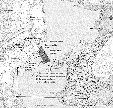
Source: Hydro-Québec. New Grand-Mère hydroelectric facility. Information Bulletin, Number 3 - summer 1998.
A 1.45-km-long access road will be built, including an intersection with Highway 153. Some short temporary roads will also be constructed to provide access to the different work sites and structures, the spoil and waste disposal site and the CN railway tracks, where shipments of heavy equipment, such as power transformers for the new station, will be received.
The project includes decommissioning the existing power station building and dismantling the associated installations (turbine-generators, equipment, etc.), in-stream backfilling (base of the draft tubes, downstream retaining wall, the downstream ends of the rockfill dike), work associated with the protective structures (right gravity dam, concrete wall, rockfill dike on the right bank) as well as razing the existing spillway and weir. The present station's water intake will serve as a retaining structure for the forebay of the new Grand-Mère hydroelectric facility.
Construction of the new facility and modification of the existing works will be carried out in three stages, which entail two phases of diversion of waters from the Saint-Maurice River. The work will include the installation of cofferdams, concreting, in-stream excavation and the use of explosives.
The excavation work will generate a large volume of rockfill, estimated at 1 500 000 m³. Since the amount of material that can be used in the project has been estimated at 1 059 000 m³, the surplus fill will amount to about 500 000 m³.
The proponent has opted to dump this rockfill in part of an operational sandpit located on the left bank of the river, on the other side of the CN tracks. An access road will have to be built along the tracks, and the existing railroad crossing will have to be modified to permit the passage of heavy vehicles. Hydro-Québec is still negotiating with the site owner to obtain an easement in perpetuity for the operational part of the sandpit where the surplus rockfill is to be dumped.
2.3.2. Facility management
The new power station will be designed to adjust rapidly to an operating flow of between 200 and 1 040 m³/s during the winter. From mid-March to mid-December, the station will be managed as it is now; the water in the reservoir will be maintained near the maximum level in order to optimize the facility's output.
In winter (mid-December to mid-March), Hydro-Québec will adjust its production schedule so that the power station contributes to peak production, concurrently with the stations located downstream. In a given day, these stations will operate at flows of up to 1 040 m³/s during one or two peak periods and at reduced flows of 200 to 400 m³/s during off-peak periods.
The peak generating schedule for each day will be adjusted according to demand and technical constraints. Three operating modes will exist: 1) a mode to meet hourly peak demand in the morning and evening during periods of maximum demand (15 days); 2) a peak operating mode with optimal output (60 days) and 3) a normal mode the rest of the time (15 days). When operating in maximum hourly peak mode, the Grand-Mère station's turbines will handle flows of 255 m³/s during the off-peak period (13 hours) and flows of 1 040 m³/s during peak periods (11 hours). In optimal peak mode, the station will handle flows of 225 m³/s during the night (7 hours) and flows of 830 m³/s the rest of the day (17 hours).
The proponent has stated that it will endeavour to optimize the hourly peak mode to help maintain the stability of the ice cover.
The water-level fluctuations attributable to this new mode of operation will differ in each section of the river affected by the project. Figures 2 and 3 show the location of the different forebays and afterbays involved.
During the cold season, the daily water-level fluctuation range in the Grand-Mère forebay will be about 0.7 m before the ice cover forms, compared with 0.9 m afterward. These fluctuations, albeit greater than the existing variations (0.3 m), nonetheless fall within the reservoir's minimum and maximum operating levels (101.19 m and 102.56 m).
Two management modes for water-level fluctuations will be adopted in the stretch of river between the Grand-Mère and Shawinigan power stations. In this sector, the water-level fluctuation ranges observed between the dam and the Hêtres Rapids will be the largest recorded in relation to the different forebays and afterbays affected by the project. After the project is completed, the maximum fluctuation range, currently about 0.5 m at the Hêtres Rapids, will increase to 1.43 m, whereas at the power station the range will increase from 0.8 m to about 2 m, depending on whether or not the ice cover has formed. These flow variations will make it necessary to install an ice boom, from October or November to the following spring, immediately upstream of the Hêtres Rapids to improve the stability of the ice cover in this sector.
The water-level variations observed in the downstream reach, comprised between the Hêtres Rapids and the Shawinigan power station, will be of similar amplitude or smaller than the maximum fluctuations already recorded between the two sites.
Depending on the generating mode in effect, slight increases or decreases in the existing maximum fluctuation ranges will also occur in the stretch of river between the Shawinigan and La Gabelle dams following adoption of the new winter operating modes. With the exception of the upper reservoir at La Gabelle, which requires a 0.5 m decrease in the minimum operating level, the water-level fluctuations in the other forebays and afterbays of the power stations affected by the project will fall within the current range of maximum water-level fluctuations under normal operating conditions.
Figure 2. Local and extended study area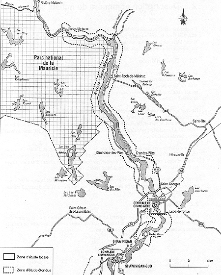
Source: Hydro-Québec. New Grand-Mère hydroelectric facility, 1998, Figure 2.1.
Figure 3. Zone of influence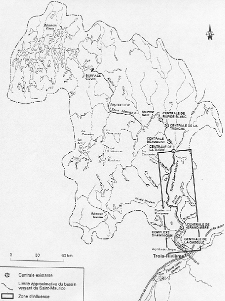
Source: Hydro-Québec. New Grand-Mère hydroelectric facility, 1998, Figure 2.2.
2.4. Cost and completion schedule
The cost of the new Grand-Mère hydroelectric facility is estimated at $454 million and meets the proponent's cost-effectiveness criterion (production cost less than 3¢/kWh). The construction work is scheduled to begin in March 2000, with the commissioning of the new power station slated for the spring of 2004.
3. Environmental Assessment and the Applicable Regulatory Framework
An environmental assessment of the project is required under the Canadian Environmental Assessment Act (CEAA), because of the associated loss of productive capacity of fish habitat, a situation requiring the issuance of an authorization pursuant to subsection 35(2) of the Fisheries Act. This type of authorization is a triggering factor for the CEAA pursuant to the Law List Regulations.
Before such an authorization can be granted, the proponent must propose a compensation measure that complies with the principle of no net loss of productive habitat capacity, as specified in DFO's Policy for the Management of Fish Habitat. This measure must be covered by legal obligations set out in a compensation agreement between the proponent and DFO.
As stipulated in subsection 4(b) if the Comprehensive Study List Regulations, a project to build, decommission or close a power station with a generating capability of 200 MW or over necessitates the completion of a comprehensive study type of environmental assessment.
A comprehensive study under the CEAA is a self-directed environmental assessment method, whereby the responsible federal authority examines the environmental effects of a project prior to making any irrevocable decisions about it.
Within the meaning of the CEAA, the Department of Fisheries and Oceans (DFO), acting through the Fish Habitat Management Division, is the sole responsible federal authority in this dossier. DFO has taken steps to ensure that the environmental assessment process and the comprehensive study adhere to the requirements of the CEAA.
Other federal departments were also consulted to determine their powers and duties pertaining to the project and to seek their comments about their respective requirements relative to the environmental assessment process under the CEAA. They are the Department of Indian and Northern Affairs (DIAND), Environment Canada (EC), Natural Resources Canada (NRCan), Parks Canada (PC) and the Transportation Safety Board of Canada. The Canadian Environmental Assessment Agency also collaborated in this dossier by dealing with questions related to the interpretation of the CEAA and methodology.
DIAND does not plan to exercise any powers in relation to the project since the targeted site is not Indian land and is not part of an Atikamekw Nation Council land claim which has been recognized and approved by this Department.
EC is serving as an expert department for the project in its areas of expertise, specifically avifauna and wetlands. To be able to properly evaluate the effects on bird life, EC has requested that breeding bird surveys be conducted within the habitats that will be destroyed during the construction phase of the project.
NRCan, in its capacity as expert federal authority, can provide advice on the use and storage of explosives and on the legal requirements pertaining to the facilities needed for the manufacture of explosives at a construction site. Under the terms of the Explosives Act, NRCan is required to issue a licence for the storage or manufacture of explosives, and the issuance of such a licence necessitates an environmental assessment under the CEAA. A request for information on this topic has been made to the proponent. To date, it has not yet been determined whether a licence of that type will be required.
PC has no particular involvement in the project, since the operating mode for the new generating station will not affect water levels in the area bordering La Mauricie National Park, for which it is manager. The Cultural Heritage and Real Property division of Parks Canada has provided an expert opinion on protection of the built and technological heritage likely to be affected by the project.
The Transportation Safety Board of Canada does not plan to exercise any powers related to the project under the Railway Safety Act. However, modification of the railroad crossing to permit the passage of heavy vehicles will require the signing of an agreement with CN containing the necessary administrative clauses on the construction and maintenance of the railroad crossing.
At the provincial level, the project is subject to section 31.1 of Quebec's Environment Quality Act, which calls for an assessment and review of the environmental impacts. The Department of Fisheries and Oceans and Environment Canada participated in the screening analysis of the draft study prepared as part of the provincial assessment process. The Quebec Department of the Environment mailed their comments to the proponent, together with the input from the various Quebec departments and agencies involved. The two federal agencies concerned provided the same comments as during the CEAA process.
4. Scope of the Project and the Environmental Assessment
The scope of the project includes the construction of the power station, control structures and sending-end station, the demolition of the existing control structures and spillway, the decommissioning of the existing generating station and the modification of the wintertime operating mode on the Saint-Maurice River.
The environmental assessment includes a review of the environmental effects of the project, including the effects of malfunctions or accidents that may occur in connection with the project, and cumulative effects that are likely to result from the project, in combination with other projects or activities that have been or will be carried out.
Environmental effects, as defined in subsection 2(1) of the CEAA are changes that the project may cause to the biophysical environment, including any effect of such change on human health and socio-economic conditions, on physical and cultural heritage (historical, archaeological, paleontological, and architectural), and on the current use of lands and resources for traditional purposes by Aboriginal persons.
The study also covers the following elements:
- purpose of the project;
- alternative means of carrying out the project;
- significance of the environmental effects;
- effects that the environment may have on the project;
- public comments;
- mitigation measures;
- need for and requirements of a follow-up program;
- evaluation of the extent to which the renewable resources that are likely to be impacted appreciably by the project can meet the needs of the present generation while ensuring that the needs of future generations are met as well.
The environmental assessment of the project is also based on the Quebec Department of the Environment and Wildlife directive, issued in 1994, specifying the nature, scope and extent of the environmental impact study, along with the specific requirements set forth by federal authorities, such as DFO's Policy for the Management of Fish Habitat setting out the no net loss principle for fish habitat and the Federal Policy on Wetland Conservation.
Depending on the magnitude of the anticipated impacts, the boundaries of the study area can be divided into three distinct zones, the local study area (Figures 1 and 2), the extended study area (Figure 2) and the zone of influence (Figure 3).
The local study zone, which is about 1.5 km long, covers the sector most likely to be affected by the project. It is delimited upstream by the Highway 153 bridge and downstream by the CN bridge. The zone of influence, comprised between Manigance Rapids in the north and Hêtres Rapids in the south, is the sector directly affected by the water-level fluctuations associated with the operation of the Grand-Mère power station. The zone of influence stretches from La Tuque, upstream, to the Forges Rapids, downstream.
5. Public Consultations Program
5.1. Hydro-Québec's communications program
This section summarizes the key information on the communications program contained in Chapter 1.3 of Volume 1 of the proponent's draft-design report. For example, a list of the various organizations contacted is provided, along with a table summarizing the issues, concerns and demands expressed by the local community during the proponent's information tours.
5.1.1. Communications process
After the project was launched in December 1991, three public information and consultation tours were carried out. The first tour, conducted in February 1992, was intended to provide the community with general information about the studies initiated with respect to the construction of a new generating station and Hydro-Québec's intentions. Two potential development options were presented, along with the technical and environmental studies to be conducted during the first phase of work, and the upcoming communication phases. During a second information tour, in November 1995, the proponent presented the option selected for the second phase of the draft-design process and provided local residents with information on the progress achieved in the project. A final information tour was conducted in September 1998 to take stock once again of the rationale for the project, to summarize the optimized features of the development, to describe the impacts and mitigation measures and to outline the regional economic benefits of the project.
Three information bulletins (January 1992, November 1995 and August 1998) and a fact sheet (August 1995) were prepared and distributed prior to the information tours. Two public meetings (1992 and 1998) and a press conference (1998) were also held.
In all, some 50 organizations or groups were invited to the communication sessions or received fact sheets. About a dozen meetings were organized during each tour and, on average, 20 organizations or groups participated in them.
These meetings brought together organizations, groups and individuals concerned by the project (departments, municipalities, RCMs, economic groups, environmental, recreation and tourism and cultural groups, and landowners affected by the project) and enabled the proponent to inform interested parties and obtain their input.
During each of the communication stages, the proponent recorded the concerns and requests formulated by the community and took account of these in the study orientations as well as in establishing the final project. Hydro-Québec addressed community requests and demands by providing answers or making specific undertakings.
The proponent also stated that it maintained close contact with community representatives and a number of groups and organizations following consultations concerning upgrading projects at the four existing hydroelectric facilities (La Gabelle, Shawinigan-2, Shawinigan-3 and La Tuque) and the draft designs for the construction of two new generating stations (Rapides-des-Cœurs, Rapides-de-la-Chaudière) or the partial diversion of the Mégiscane River.
5.1.2. Concerns and issues raised by the community
The main concerns of the groups and organizations consulted in the project relate to:
- local economic spinoffs;
- management of the excavation fill and the construction site activities;
- role of the former generating station;
- effects on spawning grounds;
- resuspension of contaminated sediments;
- addition of transmission lines.
Some groups and organizations also expressed concern that the new wintertime management method for the generating station could cause ice push-ridges along the river banks which might hinder access to the river for winter activities. The proponent identified this impact as a project issue. The measures proposed by the proponent with the aim of mitigating this impact are discussed in Section 7.6.2.
Other concerns and issues were raised in relation to regional economic spinoffs and the multiplicity of recreation and tourism activities associated with the river, necessitating the construction of structures that will enable boats to bypass the existing hydroelectric facilities, including those being upgraded.
5.1.3. Hydro-Québec responses and undertakings
In some cases, the information provided by the proponent helped to alleviate concerns and satisfy community expectations. This is the case with effects on spawning grounds (habitat loss will be compensated), resuspension of sediments (no displacement of contaminated sediments will occur in the project), construction site activities (negligible impact), the addition of transmission lines (no plans for this, since new lines will be built only in response to increased demand and not in connection with an increase in the power station's capacity) and economic spinoffs (measures to maximize spinoff at the local and regional levels).
In the draft-design report, Hydro-Québec mentioned that the two solutions put forward for excavated material management presented advantages and drawbacks for municipalities on the left bank and the Centre-de-la-Mauricie RCM, which were concerned about this matter. Hydro-Québec therefore asked those agencies to participate in the discussions and collaborate on devising an acceptable solution.
In view of the heritage value of the existing power station, Hydro-Québec said that it was willing to form an advisory committee to analyse proposals from the local community regarding possible uses for the station. However, Hydro-Québec has not made any undertakings to make the existing plant available to the community.
With regard to recreational use of the river during the winter, Hydro-Québec has stressed that it will maintain contacts with users in order to solve potential problems of river access. As for the additional risks to users connected with the stability of the ice cover in the Hêtres Rapids sector, the proponent plans to raise local residents' awareness of this issue and monitor ice conditions, but it cannot undertake to guarantee the safety of the area, given that unsafe conditions already exist there.
The request to build a lock to allow boats to bypass the Grand-Mère hydroelectric facility is part of a broader scheme covering all of the Hydro-Québec facilities and aimed at making the river navigable along much of its course. Hydro-Québec has not made any undertakings with respect to modifying its facilities in this regard, but it has agreed to estimate the cost of such a development. The proponent indicated nonetheless that boating-related projects may be proposed within the framework of the integrated enterprise development program (PMVI).
5.1.4. Positions of the various groups and agencies
The proponent pointed out that none of the organizations that participated in the information meetings were opposed to the project and that some organizations had even indicated their support for it. These include the Centre-de-la-Mauricie RCM, municipalities affected by the construction work (Grand-Mère, Saint-Georges and Lac-à-la-Tortue), MNAs for the ridings of Laviolette and Trois-Rivières, the federal Member of Parliament for the Saint-Maurice riding, and the president of the Corporation de gestion du développement du bassin de la rivière Saint-Maurice (CGDBR).
5.2. Public consultations under the CEAA
A period for public comments is provided following the submission of the comprehensive study report to the Canadian Environmental Assessment Agency. During this period, members of the public may consult the report and express their opinions and concerns about the environmental effects of the project.
6. Description of the Existing Environment
Volume 2 of the draft-design report provides a detailed description of the environment and of the inventory methods used to characterize it, while Chapter 2 of Volume 1 gives a summary description of the environmental components likely to be affected by the project. In the section below, the main environmental components of the study area are summarized.
6.1. Physical environment
6.1.1. Physiography and soils
Physiographically, the study area is bounded by the Laurentian foothills in the north and the St. Lawrence lowlands in the south.
In the stretch of river between the Grand-Mère Dam and the Manigance Rapids, 52% of the riverbanks are subject to heavy, medium or light erosion, whereas the erosion that occurs elsewhere in the region is considered negligible, since the banks are rocky or already have protection. Some 15% of the riverbank areas, particularly those composed of clay and silt, are described as undergoing active erosion (21% of right bank and 8.5 % of left bank).
The riverbank sectors between the Grand-Mère and Shawinigan dams are also highly sensitive to erosion, especially on the left bank, where the sensitive proportion is 33.5%. However, less than 2% of all the riverbank sections show signs of instability.
In the Shawinigan-La Gabelle sector, more than 80% of the areas on the right bank, which are predominantly clayey and steeply sloped, show a high degree of vulnerability to erosion (50% of the whole sector). Nearly 21% of these riverbank areas are undergoing erosion, particularly in the sector downstream from the railway bridge, within the zone of influence of the La Gabelle generating station.
Undercutting by waves at the base of talus slopes and landslides are the main erosional phenomena observed. The discontinuation of timber driving activities, the attendant dismantling of log booms and the associated increase in boating activities, especially in the area upstream from the Grand-Mère facility, will augment riverbank erosion in sensitive spots.
6.1.2. Hydrography
In the Saint-Maurice River basin, covering an area of 43 250 km², there are eight dams (Figure 3) on the main reach of the river (Rapide-Blanc, Trenche, Beaumont, La Tuque, Grand-Mère, Shawinigan-2, Shawinigan-3 and La Gabelle), one dam at the outlet of the uppermost reservoir on the river (Gouin Dam), and several dams on the Manouane and Matawin rivers, which are tributaries of the Saint-Maurice. Collectively, these works make the Saint-Maurice one of the most regulated rivers in the world. The reservoir of the Grand-Mère power station receives inflows of water from the La Tuque station, as well as from tributaries in the intermediate part of the drainage basin situated between the two sites, including the Aux Rats, Wessonneau, Matawin and Mékinac rivers.
6.1.3. Ice cover
In the forebay of the Grand-Mère power station, the ice cover forms as soon as winter begins and, aside from some ice-free areas in the fast-flowing sectors upstream from Mékinac, the entire area from the Manigance Rapids to the Grand-Mère station becomes covered with ice. Downstream from the facility, the ice cover forms more slowly owing to the higher current velocity, and ice formation begins along the banks and moves toward the middle of the river, with a complete ice cover eventually forming between the area upstream of Hêtres Rapids and the area upstream of the Beaurivage sector.
6.1.4. Water quality
The river water is considered to be of good quality. The municipalities of La Tuque, Grandes-Piles, Grand-Mère, Saint-Georges and Shawinigan all have sewage treatment plants. The same is true also for the Abitibi-Consolidated mills at Grand-Mère and La Tuque, the Belgo plant at Shawinigan, and the Canadian Pacific Forest Products (CPFP) mill at La Tuque.
6.1.5. Sediments
The inventory of the sediments found in the forebay of the power station shows that fine materials are present near the riverbanks, with the coarsest materials occurring toward the middle of the river.
Analyses of the fine sediments in this sector show that there is no severe contamination by the organic and inorganic parameters tested. Only one sampling station, situated in a small bay near the Highway 153 bridge, which still occasionally receives discharges from an old sewage outfall, presented some exceedances of the protection criterion relative to lead and mercury levels. Commissioning of the new power station will not, however, cause the resuspension of those sediments.
In the afterbay, the riverbed is rocky or composed of sand or gravel.
6.2. Biological environment
6.2.1. Fish fauna and fish habitat
In all, 26 fish species were inventoried in the area between Shawinigan and La Tuque. Species of interest for fishing include walleye, yellow perch, smallmouth bass, northern pike, brook trout, white sucker and longnose sucker. These species are found both upstream and downstream from the Grand-Mère facility. Occasional catches of Atlantic salmon and muskellunge were also made downstream from the Grand-Mère power station.
Atlantic salmon and American eel are the only two migratory species likely to occur in the study area.
Atlantic salmon, introduced into some waterbodies upstream of Grand-Mère (Taureau Reservoir, and Mékinac, Inman and Dunbar lakes) occasionally swim into the Mékinac and Matawin rivers and from there into the Saint-Maurice. However, this nonindigenous species appears only occasionally in the sector downstream from the Grand-Mère facility.
There are reports of American eels being found in the afterbay of the Grand-Mère generating station. However, this occurrence is considered unusual, since the eels would have to get over a 44-m-high drop at the Shawinigan complex, located 16 kilometres downstream, in order to reach that area. Furthermore, experimental fishing conducted to date has not turned up any sign of the species' presence between the two dams in question, and it is not known to have occurred beyond the Grand-Mère facility. The existence of a series of large falls and cascades at the site of the present hydroelectric facilities has no doubt always impeded American eel migration in this sector.
The smallmouth bass population that is found between the generating station and the Hêtres Rapids is considered to be at risk, since its abundance level is low and sport catches are small as well. In 1997 in an effort to promote the species' production, GDG Conseil Inc. established wildlife enhancements in the Beaurivage sector, which is between the CN bridge and the Hêtres Rapids. The enhancement structures consist of two or three large boulders which were installed in order to block the current. In addition, gravel material (20 to 45 mm in diameter) was provided to permit the construction of nests.
Inventories conducted between the Grand-Mère station and the Hêtres Rapids confirmed the presence of three spawning grounds in fast-flowing water and two spawning sites in slow-moving waters. About a dozen aquatic beds, containing known or potential fish habitats, were also identified between the Grand-Mère and La Gabelle dams (GDG, 1997).
In the local study area, smallmouth bass spawn in an area covering at least 150 m², which is part of a shoal located at the foot of the left gravity dam. White sucker also spawn in this shoal (1 547 m²) and in another shoal near the left bank, downstream from Simard Point (10 300 m²). Yellow perch use a small area of riparian scrubland on the right riverbank opposite Simard Point, at the northern end of the beach where the industrial outfall is located. In view of the prevailing hydraulic conditions at this spot, this habitat is of little value at present and the new conditions that are anticipated will not change the situation appreciably. In addition, although no walleye spawning grounds were identified, it is possible that the species spawns in the local study area.
6.2.2. Avifauna
With over 118 bird species observed in the extended study area and the surrounding region, the sector has a fairly high diversity of bird species. The Atlas of Breeding Birds (Gauthier and Aubry, 1995) reports data on the confirmed nesting of some 50 species. In the riparian environment, given the limited areal extent of wetlands, the fairly straight riverbanks and anthropogenic disturbances, favourable habitats for waterfowl and shorebirds seem to be in short supply. The proponent did not identify any special or unusual habitats in the local study area.
6.2.3. Riparian and aquatic vegetation
Aquatic beds are the most common type of wetland in the study area. From the Manigance Rapids to the La Gabelle power station, habitats of this type occupy an area of about 198 ha. They are most abundant in the forebays of the Grand-Mère (118 ha) and Shawinigan (35 ha) generating stations.
Tapeweed assemblages largely dominate the plant communities of the aquatic beds sampled between the Highway 153 bridge and the Hêtres Rapids. Other plants include Canada waterweed, needle spikerush and emersed pondweed, which are deep-rooting perennial species. These plants are evenly distributed at a depth range of 0.5 to 2 m.
Emergent weedbeds (marsh), found at depths between 0 and 0.5 m, are composed primarily of marsh bedstraw and aquatic zizania (wildrice), with some Pennsylvania knotweed. Wet meadows and shrub swamp occupy the part of the floodplain that is exposed during the low-water period in summer, with the dominant plant assemblages of those habitats being reed canary-grass and alders and willows, respectively.
The local study area comprises three aquatic beds and two marshes (emergent weedbeds), including one located on the left bank upstream from the existing weir and the other at the future disposal site for excavated material. Wet meadow and shrub swamp habitats appear to be poorly represented in the local and extended study areas downstream from the Grand-Mère facility. In the downstream part of the zone of influence, development of scrubland and aquatic beds is limited by the rocky substrates bordering the river and the steep banks.
6.3. Human environment
6.3.1. Socio-economic and socio-demographic profile
The study area is situated almost entirely within the Centre-de-la-Mauricie RCM, which encompasses about 15 municipalities, 10 of which border the Saint-Maurice River. The most populous cities are Shawinigan, Shawinigan-Sud, Grand-Mère and Saint-Georges. This RCM stands out from other areas of Quebec by the fact that its primary and secondary sectors are more fully developed, but its tertiary sector is less developed, though it is expanding rapidly. The unemployment rate is high, or about 18%. There are no North American Indian communities within the study area. Three Native communities, the Weymontachie, Obedjiwan and Manouane reserves, are situated on land outside the project's zone of influence.
6.3.2. Recreation and tourism
The La Mauricie National Park, the Shawinigan Falls regional park and the Saint-Jean-des-Piles-Grandes-Piles sector are the main centres of recreation and tourism in the region. The Saint-Maurice River, which in summer 1996 was used by more than 15 000 pleasure boating enthusiasts (motor boats, canoes, etc.), is the venue for a major annual canoeing event called the "Classique internationale de canots de la Mauricie." Following the dismantling of the booms formerly used to float timber downstream to paper mills, the river became completely accessible to boats between the Grand-Mère Dam and the Manigance Rapids. The bay near the Grand-Mère golf course, Desaulniers Point and Simard Point, along with the area just downstream from the generating station, are frequented by fishermen during the summer.
In winter, ice fishing is conducted in a number spots within the extended study area. Three fishing sites were identified by the proponent in 1996: the bay on the right bank just upstream from the Auberge de Grand-Mère and the bays downstream from the village of Saint-Roch-de-Mékinac and Ile aux Pins. Snowmobilers and all-terrain vehicle operators also use the river. There are some groomed trails and spontaneous trails which give access to the river, including one trail leading to the left bank upstream from the existing weir. Trail No. 3 of the national snowmobiling network crosses the Saint-Maurice north of the La Gabelle Dam, while provincial trails 347 and 318, located upstream from the Grand-Mère Dam, are among the most popular snowmobile trails in the extended study area. In 1996, it was estimated that more than 13 500 people visited the area between the La Gabelle generating station and the Manigance Rapids during the winter.
6.3.3. Land use
In the immediate area of the municipality of Grand-Mère, there is very little vacant land. Abitibi-Consolidated's industrial facilities are located there, and so is an extraction site operated by Construction et Pavage Maskimo, some CN property and a residential zone. It should be noted that the Grand-Mère generating station can only be reached by crossing the paper mill's land. On the left bank, the majority of parcels of land between the railway tracks and the Highway 153 bridge belong to Hydro-Québec. Entreprises Grand-Mère-Est owns some land near Highway 153, but the land located at Lac-à-la-Tortue belongs to Excavation Gaston Trépanier.
6.3.4. Archaeology and heritage
Six zones within the local study area have components of potential archaeological significance that may be affected by the construction work. The inventory did not uncover any evidence of prehistoric human occupation, however. From a historical viewpoint, the structures or artifacts identified in the construction area are of limited industrial, architectural or heritage significance.
According to a study done by Hydro-Québec, the Grand-Mère hydroelectric station, whose architecture is based on that of a gothic cathedral in France (Sainte-Cécile d'Albi), is considered one of the three most promising facilities from a heritage standpoint out of about 90 hydroelectric complexes evaluated. Its heritage value is not limited to the station building itself, since the retaining and control structures still rank as part of the most important multiple-component concrete dams ever built in Quebec. Many of the site's electrical and mechanical components also have an exceptional, very high or high heritage value.
7. Anticipated Effects, Significance of the Effects and Mitigation Measures
Chapter 5 of Volume 1 of the draft-design report describes the alterations to the physical environment associated with the project and the foreseeable impacts on the natural and human environment. Chapter 5 and Appendix A outline the method used by the proponent to analyse and evaluate the impacts, while Appendix B of the same document contains the complete list of mitigation measures mentioned in Chapter 5 of the report.
The section that follows summarizes the environmental changes and provides an assessment of the main environmental effects resulting from the project, including the effects of any malfunctions or accidents that may occur in connection with it, as well as the cumulative effects. The primary mitigation measures are also mentioned.
It should be noted that the impact assessment prepared by the proponent is based on a worst-case scenario in which peak flow at the new Grand-Mère power station would vary between 200 m³/s and 1 040 m³/s every day during the winter. The most significant impacts will occur mainly during the first few years after commissioning, when the proponent is still adjusting its operating mode.
7.1. Impact assessment methodology
The proponent evaluated the impacts before and after the implementation of mitigation measures, for all the different components of the natural and human environment concerned. However, no residual impacts were identified in relation to elements of the physical environment. As a result, the discussion centres on modifications in components and the term "impact" is not used in this context. The method used by the proponent to predict impacts consists in first delineating alterations to the physical environment and then assessing the effects on living components of the environment, namely humans and fauna and flora. Suitable mitigation measures are then applied to each element to obtain the lowest possible residual impact.
The significance of each impact, qualified as either low, medium or high, was evaluated using a grid comprising three descriptors, namely duration, extent and intensity.
This nomenclature differs from that used to define the environmental effects of a project under the CEAA, in which an adverse effect must be defined as either significant, non-significant or unknown.
In its complementary report, the proponent stated that a high impact corresponds to a significant effect, as defined in theCEAA, whereas a medium or low impact, corresponds to a non-significant impact.
DFO agrees with that approach.
Table 2 presents the impact assessment prepared by the proponent for all the environmental components likely to be affected by the project. DFO's comments with respect to those evaluations are provided in the sections below. Certain environmental components that will be subject only to non-significant environmental effects are not covered in the summary below (water quality, air quality, noise environment, etc.).
Table 2: Assessment of impacts prepared by the proponent for the different environmental components affected by the project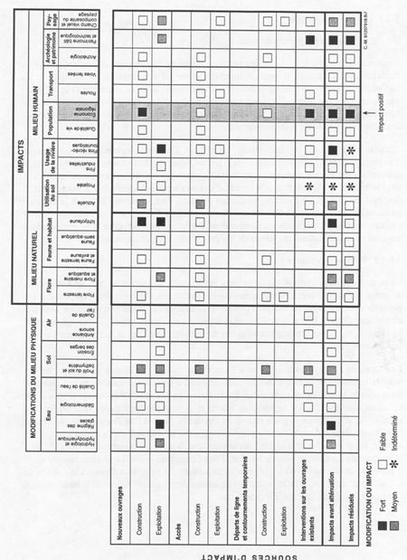
7.2. Alterations to the physical environment associated with the project
The main project effect on the physical environment consists in the alteration of the ice regime resulting from the operation of the new works during the winter period. Hydrological and hydrodynamic changes are also anticipated, as are soil profile and bathymetric modifications.
Water-level fluctuations caused by daily variations in flow during the winter will create cracks, ice-push ridges and water seepages in the ice cover along the riverbanks, which may hinder access to the water and ice fishing activities. Modification of the hydraulic management mode used in winter will also increase the risk of pressure being exerted on the ice sheet, making the sections of ice cover between the Grand-Mère power station and Ile Frigon, as well as between the Shawinigan complex and Madeleine Falls, unsuitable for traffic to various extents, given the surface roughness and risks of downstream ices movement. The significant impacts anticipated on the ice regime and the associated mitigation measures are discussed in Section 7.6.2 of this report, which deals with the effects of the environmental changes on socio-economic conditions.
As a result of the modifications in the hydrological regime, the shoals located downstream from the new control structure will be completely eroded by average floods. Some 50 000 m³ of sand, pebbles and rock will be entrained by the flow. Coarse sediments will be deposited in the local study area, whereas finer sediments will settle out farther downstream, in the extended study area. This impact, deemed as non-significant from a sedimentological viewpoint, will nonetheless have repercussions on the fish fauna. This aspect is dealt with in Section 7.3.1 below.
Low impacts are anticipated with regard to shoreline erosion (detachment of ice and water current velocity), since the project should only affect a few highly eroded talus slopes without destabilizing any additional ones. Follow-up will moreover be conducted in this regard, and stabilization measures will be implemented to deal with any shoreline erosion and any sensitive elements requiring protection.
7.3. Effects of the project on environmental components
7.3.1. Fish fauna and fish habitat
The changes in the hydrological regime resulting from the orientation of the new spillway as well as from the water-level fluctuations attributable to the new peak generating mode used at the power station in winter are the main factors likely to have impacts on fish habitat. The new operating mode used at the facility will exert an effect through active erosion caused by ice scour on the bottom, the banks and the riparian and aquatic vegetation.
In the local study area, the cofferdam and in-stream excavation work will cause the abandonment of the spawning ground situated near the left gravity dam. The commissioning of the new control structures will cause major hydrodynamic modifications to the environment. A shoal consisting of pebbles and boulders in a sand matrix which is located downstream from the left gravity dam will be seriously damaged when the first average flood occurs. In all, 30 000 m³ of sediment will be displaced. The spawning ground in this zone which is used by smallmouth bass (150 m²) and sucker (1 547 m²) will probably disappear once the new generating station starts up. In addition, the spawning ground located downstream from Simard Point will be silted up over an expanse of about 3 100 m², or 30% of its present area.
The majority of sediments that are displaced will be deposited in the local study area. The finest sand particles will settle out at a slow rate (1 mm per year), in the still water zones or in deeper sections within the extended study area, where sand entrained during the flood is deposited. The project will not cause any changes in the sedimentation and erosion zones that exist at present in the sector. Consequently, the risk of siltation of potential spawning grounds or nursery areas in the aquatic beds is considered very low.
The spawning and feeding areas located in the afterbay within the extended study area are situated in sheltered zones and will undergo less shoreline erosion as a result of ice cover movement associated with the new winter operating mode. The aquatic beds should not be affected by this phenomenon, given their rooting depth. Riparian herbaceous meadows, a habitat likely to contain spawning sites for yellow perch, may however be affected by ice scour and so may be replaced by herbaceous plants that are better able to adapt to these conditions.
Monitoring of the aquatic beds and riparian habitats will be done to assess the effect of the project on these environments and, if necessary, to implement appropriate mitigation measures or compensation options if fish habitat losses are observed.
The enhancement structures for smallmouth bass, located in the sector between Ormes Point and the Hêtres Rapids, will probably not be affected by the new management method to be used at the Grand-Mère power station in winter, since these enhancements are designed to withstand average spring flows (2 600 m³/s), which are higher than the peak winter flow (1 040 m³/s) that will be generated by the new generating station.
Two embankments are to be built downstream from the existing power station, encroaching on the aquatic environment over an area of roughly 5 700 m². Nonetheless, these structures will be located in a sector of little interest for aquatic fauna, given the present flow velocity at the outlet from the existing station. The unconsolidated material that is to be used for these rockfill embankments will also provide supporting structures and shelters for aquatic fauna once the hydrological conditions in the sector become more favourable, following the commissioning of the new power station. The excavation of the headrace and tailrace will increase the size of the aquatic habitat by about 45 000 m².
The access road that is to be built will, however, create an encroachment of about 300 m² onto a small marsh at the back of the bay, on the left bank, near the Highway 153 bridge. This site, which is located near a known nursery area, may possibly be used by certain fish species for spawning, such as yellow perch.
In all, roughly 4 800 m² of known spawning grounds and some 300 m² of potential fish spawning areas may be permanently destroyed as a result of the project.
The effect that the construction and operation of the project will have on fish habitat is considered significant and requires an authorization under subsection 35(2) of the Fisheries Act. In accordance with the no net loss principle set out inDFO's Policy for the Management of Fish Habitat, the authorization will be issued only if compensation is provided for the habitat losses.
The compensation measure to be implemented consists in the creation of a multispecies spawning ground (for smallmouth bass, walleye and suckers) downstream from the left gravity dam and a spawning area for yellow perch in the small marsh located on the left bank of the river, in the forebay.
The spawning ground to be created just downstream from the Grand-Mère Dam (about 9 000 m²) will be composed of rocky substrate material of varying diameter: between 5 and 30 cm to suit the needs of walleye and suckers; large boulders over 80 cm in diameter and fine particles about 5 cm in diameter for smallmouth bass. The shelf underpinning this new spawning area will be made by excavating five straight trenches to create a variety of depths and flow velocities across the entire site.
The spawning ground upstream from the Grand-Mère facility will be created by planting shrubs (alder) at the base of the access road embankment in the marsh, at an elevation that will allow the vegetation to be submerged in the spring. This enhancement may be used by yellow perch, which typically spawn in such habitats.
Various measures will be applied also to mitigate the effect of the construction work on water quality, and the use of explosives will adhere to the directives aimed at protecting fish fauna (Wright and Hopky, 1998).
7.3.1.1. Fish-pass and fish guards
Subsection 20(1) of the Fisheries Act states that "Every obstruction across or in any stream where the Minister determines it to be necessary for the public interest that a fish-pass should exist shall be provided the owner or occupier with a durable and efficient fish-way or canal...
" The presence of migratory species in a stream that contains an obstruction to the movement of fish may justify installing a fish-way.
American eel and Atlantic salmon are two migratory species that may occur at the Grand-Mère site. Given the uncertainty over the presence of an eel population in the facility's afterbay and its absence in the upstream area, and given the occasional presence of specimens from a non-indigenous population, namely Atlantic salmon, in the same afterbay, and the absence of measures adopted by provincial officials (in charge of managing the fish resource) in this regard, based on our present knowledge there appears to be no justification for building a fish-pass to allow those species to swim upriver.
Furthermore, the proponent has not provided for any fish guards at the Grand-Mère facility because of: (1) the absence at this site of species capable of migrating; (2) technical constraints related to the strong flows from the generating station (design flow of 275 m³/s) which would quickly clog such structures; and (3) the absence of other preventive measures deemed truly effective at the present time.
The proponent has indicated that the risk of fish being entrained into the turbines is considered low, since there are no migratory species at the site. Resident species are less likely to be present near the water intakes, because their movement is not linked to the type of downstream migration that is part of the life cycle of migratory species. It has nonetheless been reported that some resident species, mostly fry, may become entrained in the turbines.
Since the mortality rate associated with the Kaplan turbines that are to be installed is lower on average than with the present Francis turbines, the new facility is not likely to have a greater impact than at present in terms of fish mortality. The project can therefore be considered to have a non-significant effect in this regard.
7.3.2. Avifauna
The anticipated effects on forest-dwelling birds will occur only in the local study area and are essentially linked to the loss of some 15.5 ha of forest habitats which will result from the construction of the new works (power station and sending-end substation), the work site facilities, the management of excavated rock material and the construction of access roads and transmission line right-of-ways. The proponent considers this loss of forest cover a relatively low impact in relation to avifauna, considering the abundance of such habitats in the region.
In addition, owing to the low abundance of wetlands and the presence of scarped banks, waterfowl are not well represented within the local and extended study area. Given that the aquatic beds in the extended study sector will probably be altered only a little by ice movement, the proponent has indicated that there is reason to believe that the project's impact on waterfowl will likewise be limited.
The proponent is of the view that there will be no impact on bank swallow colonies, since the sandpit sector that is likely to harbour such populations will not be affected by the project.
According to the proponent, the effect of the project on avifauna can therefore be considered minor.
However, since the Hydro-Québec study does not provide precise information on the species present in the area that will be affected by the construction work (new works, access roads, transmission lines and excavated material disposal sites) and does not permit assessment of effects on avifauna, Environment Canada has asked that the proponent conduct a series of inventories at the site prior to the start of construction in order to carefully evaluate this impact. The inventories will have to be done during the month of June prior to construction.
To minimize the effects on avian fauna, the proponent will have to clear as little forest as possible and perform the work (tree felling and access road construction, excavation material disposal and transmission lines) outside the nesting period (June and July).
The impact of the project on avifauna may be considered non-significant provided the proponent adheres to the above-mentioned mitigation measures and the inventory results provide no evidence of species in difficulty or species of particular socio-economic, cultural or scientific significance.
If those inventories reveal the presence of such species, the proponent will have to propose suitable mitigation or compensation measures deemed satisfactory by Environment Canada.
7.3.3. Riparian and aquatic vegetation
The vertical movement of ice associated with the proposed new winter operating mode is not likely to have significant environmental effects on the riparian and aquatic vegetation.
The shrub species forming the lower tier of the riparian scrubland may be altered by the movement of ice, favouring the establishment over the longer term of herbaceous species that are more tolerant of water-level fluctuations.
Plants that typify wet meadows and emergent weedbeds are also likely to be affected by ice scour. This type of impact may occur in spring, when shore ice breaks off due to the effect of the wind, storms and waves, entraining sediments and the portion of the roots of plants that is anchored in the sediment. According to the proponent, this phenomenon can already be observed every spring in the Saint-Maurice River and it will not be aggravated by the new wintertime facility management method.
Given their rooting depth, the species found in aquatic beds will probably not be affected very much by the project. A study done in the Gentilly sector shows that the thickness of the sediment layer detached by the ice will probably be small relative to the rooting depth of perennial plants.
Construction of the access road for the works will result in a 0.03 ha encroachment onto a 1.2-ha marsh located at the back of the bay on the left bank, upstream from the existing weir, whereas the disposal site planned for excavated material necessitates filling in a swamp and an artificial pond (0.5 ha) located in a sandpit.
The effect of the project on riparian and aquatic vegetation is considered non-significant. Follow-up will make it possible to check the accuracy of the proponent's predictions .
7.3.3.1. Federal Policy on Wetland Conservation
The main objective of the federal policy with respect to wetland conservation is to promote the conservation of Canada's wetlands to sustain their ecological and socio-economic functions, now and in the future. Accordingly, the goals are to strive to ensure that there is no net loss of wetland functions: (1) on all federal lands and waters (2) in areas affected by the implementation of federal programs where the loss or degradation of wetlands has reached critical levels; and (3) in sectors where federal activities affect wetlands which have been designated as having ecological or socio-economic significance for a region.
The wetlands affected by the Grand-Mère project do not satisfy any of the above conditions. Overall, however, the proponent adheres to the spirit of the Policy since it sets forth its procedure with respect to: (1) avoiding such habitats, (2) mitigating inevitable impacts, and (3) providing compensation for any residual impacts.
Small marsh upstream from the dam
The analysis shows that the proponent made every effort to prevent encroachment of the access road on the small marsh south of Highway 153; however, this encroachment proved to be unavoidable.
In terms of mitigation measures, the proponent plans to restrict traffic in this area, clear trees manually and install a culvert under the access road so the marsh will continue to receive water inflows from the stream that feeds it.
In addition, alder will be planted on the lower part of the access road embankment to promote yellow perch spawning in the sector. This compensation measure is deemed compatible with the environment's wildlife habitat potential and with the ecological function of the marsh.
With regard to other potential functions (production of renewable resources, habitat for other wildlife species organic carbon storage, water supply and filtering, soil conservation, recreation and tourism opportunities, scientific value, aesthetic value), owing to the small size of the sector concerned (0.03 ha), the proponent indicated that the impact is bound to be minor, especially along a watercourse as large as the Saint-Maurice.DFOagrees with this line of argument.
Floodplain swamp and pond at the disposal site for excavated material
The sandpit site chosen as a disposal area for excavated rocks contains a floodplain swamp and a pond (0.5 ha) is a solution that entails a lower impact than the option of storing the material alongside the river, considering the value of the habitats located there.
The proponent has indicated that it will avoid dumping fill in the northern part of the sandpit which features shrub swamp; however, fill material will be dumped in the westernmost part of these swampy areas. This small swamp was already altered a few years ago during the construction of an access road, which blocked natural drainage and increased the water level in the swamp. In view of the presence of submergent and emergent aquatic vegetation in certain spots, this environment may still serve as wildlife habitat, even in its present degraded state. It probably provides few other functions. This marsh is not linked to the Saint-Maurice River.
Although the possibility of preserving this zone was considered, this option was not retained since it would result in the whole area being surrounded by talus slopes more than 15 m tall by the time disposal site operations ended. The result would be a completely isolated excavation of little interest for wildlife.
With regard to the applicable mitigation measures, the proponent said that it sought to minimize the effects on wetlands and that it plans to plant shrubs on the talus slopes that will be created beside the swamp areas, thereby providing a natural transition between the disposal site and the surrounding environment. Additional measures may be proposed in light of the results of the bird survey, which is to be carried out in the spring of 1999.
The artificial pond that formed as a result of sand being extracted from beneath the water table constitutes a disturbed environment and is not covered by specific mitigation or compensation measures.
All other wetlands
As mentioned at the beginning of this section, there is little risk of impacting the riparian marshes and wetlands along the Saint-Maurice. A follow-up program will be carried out to assess this assumption and to implement mitigation or compensation measures in the event of impacts. In view of the low risk of effects on wetlands, measures of that type have not been developed yet.
The effect of the project on wetlands is considered non-significant, provided that the proponent adheres to the mitigation measures mentioned above and provided that the avifauna surveys that are to be conducted do not identify any species that are at risk or of particular socio-economic, cultural or scientific significance.
7.4. Effects of environmental changes on the physical and cultural heritage
The project's impact on archaeological potential can be considered non-significant, given that no evidence of prehistoric occupation was found and that the structures and artifacts identified so far have little industrial, architectural or heritage significance.
Should archaeological remains be uncovered during the earthwork, arrangements will be made to protect the site and the work will be halted until the Quebec Department of Culture and Communications gives the authorization to proceed. In addition, as provided in the provincial Regulation respecting archaeological research, the artifacts that are collected will be stored in the archaeology laboratory of the Quebec Department of Culture and Communications.
The construction of the new Grand-Mère hydroelectric facility will require razing the existing spillway and weir, which means that a major part of the largest dam on the Saint-Maurice will disappear. The heritage and technological significance of the area will also be diminished by the construction of new works alongside the elements that are to be conserved and by the operations that will be undertaken to decommission, dismantle and remove certain power station components or equipment. Decommissioning in and of itself will reduce the function of the existing installations.
Based on the proponent's evaluation, the project will have a considerable impact (a significant impact within the meaning of theCEAA) on built and technological heritage owing to the loss of the building's role and the demolition of the spillway structures. It points out, however, that the razing of the spillway structures is a less significant loss in terms of the region's built and technological heritage than the decommissioning of the power station.
With reference to the definitions of terms used by the proponent in analysing the project effects, an impact is deemed of high intensity if, as is the case for decommissioning of the Grand-Mère generating station, it affects or limits the use of a component in a significant and irrevocable manner. Taking into account the value of the component and the extent and duration of the impact, based on the grid used to evaluate the magnitude of impacts the effect is deemed considerable, despite the adoption of various mitigation measures. According to the methodology used, the loss of function of the former generating station cannot be mitigated.
The effects of the project on the built and technological heritage will have to be addressed by implementing specific mitigation measures aimed at preserving the facility's heritage value.
The proponent has proposed various mitigation measures to protect and develop the value of the built, technological and historic heritage. The main ones are as follows:
- Promote the in situ conservation of certain installations or equipment based on their heritage significance or place them in appropriate storage as applicable. The proponent proposes to keep in its own collection some 40 components of interest that are part of the existing station;
- Record the operations to dismantle a piece of equipment or a heritage installation (photographs and technical notes) and take aerial photos of the spillways and weir during the razing operation;
- Encourage a multifunctional scheme for using the building which will alter the architectural quality as little as possible;
- Promote the architectural integration of the old and new elements;
- Form a committee composed of representatives from Hydro-Québec and the local community to determine the use to be made of the existing building and a method of deriving value from the decommissioned equipment, thereby helping to preserve the region's industrial heritage.
In addition to these mitigation measures, Parks Canada recommends that a video be commissioned to illustrate the overall operations of the power station (covering everything from technology through maintenance) and that it include a commentary or schematic explanations. It also recommends that one of the six turbine units be preserved to permit the situ conservation of an element attesting to the facility's former use for power production.
DFO is of the opinion that adherence to the proposed mitigation measures related to the preservation or recording of the present heritage property, preservation of the building and consultations with the community to determine what role the existing station should play provide satisfactory means of mitigating the effects on built heritage resulting from the reduced function of the current station and the razing of certain works. The residual impact on heritage value following mitigation is therefore considered non-significant.
Preserving the existing power station building would be a positive step provided the characteristics that make it a facility of exceptional significance are maintained. Moreover, the new works should not significantly alter the heritage significance of the Grand-Mère hydroelectric facility owing to the distance separating them from the structures that are retained and the conserved structures and the proponent's concern with this matter.
7.5. Effects of the environmental changes on human health
The project is not likely to have impacts on human health. It will not cause a change in water quality, nor will there be any resuspension of sediments that exhibit exceedances of the established criterion for lead and mercury.
7.6. Effects of the environmental changes on the socio-economic situation
7.6.1. Economy and employment
Construction of the new facility will generate regional spinoffs estimated at $115 million, or about 34% of the total cost of the construction work. It will also create an estimated 1 000 person-years of employment in the region for the duration of the project. This is a significant positive impact.
7.6.2. Recreation and tourism
In the forebays of the Grand-Mère, Shawinigan and La Gabelle power stations, the new mode of operations in winter will cause the formation of cracks and ice-push ridges along the riverbanks, which may curb access to the middle of the river for winter sports (snowmobiling, all-terrain vehicles, skating, cross-country skiing, walking, car race, etc.). This change may also make vacation homes located on islands less accessible and reduce the attractiveness of fishing sites near the shoreline.
The water-level fluctuations and the presence of more irregular ice cover will prevent the practise of such activities in the fast-flowing sections of river downstream from the Grand-Mère and Shawinigan plants. However, those sectors are not used very much at present for winter recreation.
Furthermore, it will no longer be possible to reach snowmobile trail No. 347 from the point of access located on the left bank upstream from the existing weir, because the ice cover will be unstable in that area.
To mitigate those impacts, the proponent plans to reach agreement with the authorities concerned to move the snowmobile trail in order to provide access to the left bank of the river from the local network; it will also take the necessary steps to maintain river access for snowmobiling and all-terrain vehicle activities during the winter season, as of the first year of operations.
The proponent will adjust its hourly peak generating mode to promote a stable ice cover, but it will not be able to ensure safe access to the river in fast-flowing areas, no more than it can at present.
The proponent will install a winter boom upstream from the Hêtres Rapids to improve formation of the ice cover and its stability, and to prevent the occurrence of an ice jam near the rapids. As well, signage will be installed in the areas at risk and the public will be kept informed about the progress of the construction work and the new conditions that will prevail on the river.
A system for monitoring the ice cover will be established to determine whether the operating mode for the structures needs to be adjusted, in accordance with the objective of ensuring the compatibility of power station management with the recreational use of the river. It should be noted that the proponent has agreed to take the necessary measures to maintain the accessibility of the ice cover in the middle of the river.
DFO feels that the effect of the project on river access will not be significant, since some mitigation measures may be developed in conjunction with the community and they may even be stepped up in response to information collected under the proponent's programs for monitoring ice cover and the use of the Saint-Maurice for recreation and tourism purposes.
It is noteworthy that the forebay of the La Gabelle station is already affected in winter by water-level fluctuations with a range of about one metre, which cause the formation of ice-push ridges and cracks along the shoreline, and that fishing and snowmobiling activities (Trans-Québec trail No. 3) are currently practised in the sector. The fluctuations in winter therefore do not represent an entirely new situation for the local population.
It is possible that the water-level fluctuations will necessitate adjustments in such activities; however, the changes will probably not be significant, since similar conditions already exist in the vicinity of the La Gabelle facilities and since mitigation and monitoring measures will be implemented.
With regard to summer activities, moving the generating station to the left bank will cause hydrological changes which may affect the fishing spots that are currently used just downstream from the facility. Some fishing sites will disappear, but new ones will also be created. The portage road will be moved, and a boat launch ramp will be built near the future power station in order to compensate for the loss of access to the river resulting from the new infrastructure. These facilities may contribute to local recreation and tourism development, since at present there is no access road to the left bank in that sector.
7.6.3. Land use
The only possible impact identified in relation to the planned use of the land is the change in vocation of the decommissioned power station.
A joint committee made up of representatives from Hydro-Québec, the community, the municipality of Grand-Mère and Abitibi-Consolidated is currently studying the possibility of using the existing station for other purposes (educational and cultural uses, industrial use or use as office space).
Based on a study by the proponent on the multiple uses of the site (Tecsult, 1996), commercial or residential use of the generating station is not an option owing to various factors, such as quality of life, the huge cost of refurbishing the building, problems of access and parking and the isolation of the site.
Of the various options studied, commercial use of the site is the only option that would require modifying the building and possibly altering its architectural characteristics and heritage value. This type of use is very unlikely, given the above-mentioned constraints.
Educational or cultural use of the site does not appear to have much appeal, in view of the present socio-economic situation, the constraints associated with access to the building and the cost of redeveloping the facilities, and the fact that the existing regional infrastructure is adequate.
Based on the findings of that study, industrial use of the building for storage is the most promising option.
According to the proponent, there would be no impact from preserving the decommissioned building and using it for purposes other than generating hydroelectricity, provided that the station's new vocation does not result in changes to the zoning plan or an increase in traffic on the paper mill site, which has to traversed to reach the existing building.
It is unlikely that the stated options for the future use of the existing generating station will have important effects on land use. In addition, since the paper company has representatives serving on the joint committee charged with determining the fate of the former power station, it will presumably be able to defend its point of view if any significant adverse effects on land use are anticipated.
However, the evaluation of the project impacts associated with a future change in the site's vocation does not fall within the scope of the present study, since the choice of a future vocation for the power station is not linked to the authorization of the proposed facility. The project that is approved therefore constitutes a separate project within the meaning of the CEAA, since there is no interdependence or link between the proposal for the new facility and the project related to the future role of the existing station. There would be a situation of interdependence if the main project could not be implemented properly without undertaking another structure or another activity, but that is not the case at present. In addition, there is no connection between the two projects, because the decision regarding the execution of the main project does not make it necessary to build other works or carry on other activities. In fact, the fate of the existing generating station can be determined separately from the decision on whether or not to authorize the proposed hydroelectric project.
The impact that the future vocation of the generating station has on land use is thus considered independent from the project currently under evaluation. The redevelopment option that is eventually chosen should have the least possible effect on the architectural quality of the station and it should be subject to established assessment procedures in keeping with the nature of the proposal that is submitted.
7.6.4. Quality of life
The effect of the project on quality of life is deemed non-significant. Monitoring is planned in order to check the predictions made in the impact study and to ensure compliance with existing noise level standards.
7.7. Effects of environmental changes on the present traditional use of the land and resources by Aboriginal peoples
The project is not likely to have an impact in this regard since Aboriginal communities do not use the land in the sector and the construction site is not part of the land claim by the Atikamekw Nation Council.
7.8. Effect of the environment on the project
Natural events such as earthquakes and strong floods have been taken into consideration by the proponent in designing the different structures (see Section 7.9). The areas that are likely to be flooded if the Grand-Mère Dam ever breaks concurrently with breaches in the dams upstream are shown in Table 3 of the supplement to the draft-design report prepared by the proponent.
Moreover, the new facility is designed so that any exceptional flood can flow over the spillways, leaving a water level upstream from the station that is equal to or lower than the level at the existing generating station, even in the event of a 1000-year or longer-interval flood (9 480 m³/s) or the maximum probable flood (12 350 m³/s).
7.9. Impacts caused by malfunctions or accidents
The rupture or overflowing of a cofferdam by a flood exceeding the design flood, the complete or partial breach of a dam owing to wear and tear or external effects, such as an earthquake or seismic activity caused by a rockburst or flooding, and an accidental spill of oil or other substances during the construction work, are the main incidents or malfunctions potentially associated with the project.
The main precaution for cofferdam construction consists in ensuring that the design criteria take into account the duration of use of all such structures. The longer they are to be used, the greater the flood recurrence interval that must be used in designing them.
The overflowing or rupture of cofferdams would result in the materials used in their construction (sand, wood and earth) being carried off downstream along with lightweight equipment. The latter could possibly be recovered after the flood. For safety's sake, a "dam emergency" committee will decide whether the work site should be evacuated on a precautionary or emergency basis, as applicable. If time permits, steps will be taken to reduce the effects on the environment.
In view of the nature of the anticipated impacts and the very low risk, any situation of overflow, rupture or failure involving diversion structures should not have significant environmental consequences.
Chapter 1.3.4.1 of the supplement to the draft-design report provides an evaluation of the impacts that would result from a breach of dams on the Saint-Maurice River. This assessment is based on the worst-case scenario out of a total of three scenarios studied, and emergency plans have been drafted on that basis.
According to the worst-case scenario, a breach of the Gouin Dam and the dams situated farther downstream would affect 45 000 people and cause the loss of cultural and historical property, disruptions in municipal services and public utility operations (aqueduct systems, highways, telecommunications and electricity), commercial and industrial losses, losses of employment income and of private property. The physical environment would also be affected (shoreline erosion, increase in water flow velocity and rupture of the ice cover). The zones at risk of being flooded are shown in Table 3 of the supplement to the draft-design report produced by the proponent.
In terms of prevention, even after it is rebuilt the Grand-Mère Dam will continue to have the most stringent possible level of monitoring. Inspections will be done at monthly intervals until the behaviour of the structure has stabilized. In addition, the frequency of instrumentation checks will be double that for a facility whose operating behaviour is already known.
The proponent describes its emergency plan for such an incident in Chapter 4.6 of Volume 1 of the draft-design report, and provides a decision tree chart for emergencies, a list of the duties of the emergency response coordination centre and documents related to such activities. Procedures for taking action to deal with an oil spill and to manage contaminated waste and soil are also discussed.
DFO considers this assessment of impacts satisfactory, along with the precautionary measures, emergency response actions and emergency plans that are proposed by the proponent.
7.10. Effects of the project on renewable resources
The project is not likely to have significant effects on renewable resources such as water, forests, fisheries and soil.
There will be no change in the daily river discharge budget and water quality will not be altered by management of the new power station. The impact on forestland will be minimal, affecting only a very small area (15 ha) of trees with a low commercial value. The fisheries will not be affected since the spawning grounds that will be destroyed in the project will be replaced through a compensation measure. The soils that will be affected by the construction work are described as being of poor quality and having no value for agriculture.
The replacement of the generating station and associated works, which are considered obsolescent, will provide the opportunity to increase the installed capacity by 70 MW at the existing site. This approach is beneficial from a sustainable development viewpoint, since it involves enhancing the efficiency of an existing facility before considering the develoment of new sites.
7.11. Cumulative effects
This section is intended as a summary of Part 2 of the supplement to the draft-design report which deals with the assessment of the cumulative effects that will result from the construction of a new hydroelectric development at Grand-Mère. The method used to analyse these effects are in accordance with the relevant requirements of the CEAA.
The proponent identified five main issues and the environmental components associated with them following consultation withDFOand the Canadian Environmental Assessment Agency. They are discussed below. The area of study for the purpose of assessing cumulative effects is bounded by the municipality of La Tuque in the north and by the mouth of the Saint-Maurice River in the south. The time frame used for the analysis was the period 1989 to 2004, that is, from 10 years before to 10 years following construction of the new facility.
7.11.1. Physical and cultural heritage
The Grand-Mère project's effect on physical and cultural heritage consists in adding an element to the equipment upgrading projects to be implemented along the Saint-Maurice; it also contributes to the evolution of this industrial sector (e.g. discontinuation of log drives on the river). These changes have a cumulative impact on the region's industrial heritage. According to the proponent, the upgrading projects will take a heavy toll on the region's built and technological heritage.
However, many projects such as the Centre d'interprétation de l'industrie forestière at Grandes-Piles (a forestry interpretation centre focussing on river driving), the Cité de l'énergie at Shawinigan (an interpretation centre on hydroelectricity), the Centre d'interprétation de Saint-Étienne-des-Grès (showcasing the historical heritage of the La Gabelle power station), and the preservation of historically significant components at the hydroelectric facilities already upgraded by Hydro-Québec (La Gabelle, Shawinigan and La Tuque) represent means of developing the industrial heritage of the Mauricie region.
Hydro-Québec's policy and the proposed mitigation measures for protecting and developing the built heritage, along with the proponent's desire to collaborate in the process of determining the new vocation of the building and agreeing on ways to exploit the decommissioned equipment, will also help to preserve the region's industrial heritage and ensure that this impact is minimized as much as possible in the circumstances.
DFO is also of the opinion that this impact is not significant within the meaning of the CEAA, taking into account the above-mentioned mitigation measures (see Section 7.4).
7.11.2. Recreation and tourism
The cumulative effects of the different projects that will help to enhance the boating infrastructure (expansion and consolidation of marinas and boat launch ramps) and environmental quality with a view to facilitating the practise of water-related activities (sewage treatment, shoreline cleaning and discontinuation of timber driving) will promote greater use of the Saint-Maurice corridor for recreation and tourism. The expansion of summertime activities is likely to have a snowball effect on winter recreation owing to the development of visitor infrastructures.
As mentioned earlier (Section 7.6.2), the Grand-Mère project may affect recreation and tourism activities by reducing access to the river because of the change in the ice regime that will result from the new peak generating approach adopted at the power station. Over the years, the Grand-Mère project may also have cumulative effects if reduced river access ends up diminishing the area's ability to attract vacationers.
The proponent concluded by stating that the project's cumulative effects on recreation and tourism will be negligible, provided the mitigation measures are effective and the community shows a favourable response to the new conditions of river access. In fact, it states that the monitoring program and the mitigation measures developed in cooperation with the community will ensure that the residual impact is limited.
In view of the proponent's undertakings with respect to maintaining access to the ice cover in the middle of the river, the fact that ice-push ridges and cracks occur along the shore at present in the region (La Gabelle sector) and do not prevent the practise of winter activities, and the fact that mitigation measures and monitoring will be carried out in this regard,DFOconsiders that the cumulative effects of the project on recreation and tourism are not significant.
7.11.3. State of the riverbanks
As mentioned earlier (Section 7.2), the effect of the Grand-Mère project on riverbank erosion is considered small. Erosion may increase in certain sectors that are already heavily eroded, for example, at the base of very unstable talus slopes.
Considering other causes of erosion, namely the increase in boating activity following the discontinuation of timber driving, the proponent indicates that the cumulative effects may be most noticeable in the forebay of the Grand-Mère facility and, to a lesser extent, in the forebays and afterbays of the Shawinigan complex, as well as in the forebay of the La Gabelle facility.
DFO considers that the mitigation measures and a rigorous monitoring program will serve to ensure that the residual cumulative impacts on shoreline erosion are negligible.
7.11.4. Fish habitat
Different types of projects (filling, hydrodynamic changes, dredging, etc.) may cause a loss of fish habitat and necessitate compensation in accordance with the no net loss principle set out in DFO's Policy for the Management of Fish Habitat.
In its analysis of the cumulative effects on fish habitat, the proponent mentioned only the projects for which such compensation has been requested, specifically the La Gabelle hydroelectric development projects and the present project at Grand-Mère, for which replacement spawning grounds will be created.
In the Grand-Mère project, aquatic beds and marshes possibly containing still-water spawning sites and nursery areas might be adversely affected by the winter water-level fluctuations and ice scour associated with the new peak generating mode at the generating station. Increased personal watercraft traffic in shallow river areas used for spawning may also interfere with this reproductive activity.
Since the habitat loss attributable to the project is to be compensated through the creation of new spawning areas, and since a program will be undertaken to monitor the riparian and aquatic vegetation, thus providing a means of verifying the accuracy of the impact predictions (i.e. the predicted low impact on fish habitat),DFOfeels that the project should not have significant cumulative effects on fish habitat.
7.11.5. Management of excavated material
Considering that the quantity of excavated rock material (500 000 m³) may meet local needs for 10 years, if market conditions do not change, Hydro-Québec has assessed the possibility of recovering the material and using it in keeping with the principles of sustainable development. However, this alternative may cause serious prejudice to existing quarries, along with important impacts on the noise level in nearby residential neighbourhoods and effects on highways associated with rock crushing and haulage of this material. In addition, these impacts are viewed as more significant than the current effects from the operations of the two existing quarries. That is why the proponent has opted to bury the surplus excavation material in the sandpit operated by Excavation Gaston Trépanier.
DFO is of the opinion that the cumulative effects of managing the excavated rock material resulting from the Grand-Mère project are negligible.
8. Monitoring Program
Chapter 6 of Volume 1 of the draft-design report describes the monitoring and follow-up program proposed by the proponent. More precise details on monitoring of riparian and aquatic vegetation are also found in the supplement to the draft-design report.
The follow-up program basically consists of seven components related to the natural environment (compensation for fish habitat and aquatic and riparian vegetation) and the human environment (regional economy and use of the Saint-Maurice for recreation and tourism) as well as the physical environment (ice regime, shoreline erosion and noise level). The proponent will be responsible for implementing the different follow-up activities.
We feel that the follow-up activities will make it possible to achieve the primary objectives established by those programs. However, certain aspects of the follow-up work may be modified so as to permit more effective assessment of the anticipated environmental effects. That is the case, for example, for the follow-up of riparian and aquatic vegetation, since a sampling station should be added in the stretch of river between the Grand-Mère facility and the Hêtre Rapids, which has the highest water-level fluctuation range.
The results of the follow-up activities are to be relayed to DFO, which may request any necessary adjustments in light of the findings.
9. Approval Conditions
The approval conditions in the comprehensive study are as follows:
- The proponent is required to implement mitigation measures, together with the follow-up programs mentioned in the different documents prepared by same as well as herein;
- Prior to the start of work the proponent must conduct the avifauna surveys requested by Environment Canada and then relay the findings to it. If these studies identify species that are rare, vulnerable or threatened or likely to be designated as such, the proponent will be required to implement appropriate mitigation measures as approved by Environment Canada;
- The proponent must sign a compensation agreement with DFO which will specify the enhancements and follow-up conditions required in order to compensate the fish habitat loss attributable to the project;
- In the course of monitoring the aquatic and riparian vegetation, the proponent must undertake to evaluate the fish habitat losses that are likely to occur in such environments as a result of erosional effects of ice scour associated with the project. Any fish habitat losses that are noted will have to be compensated.
10. Conclusion
Further to the analysis of the nature of the project, the description of the construction work, the infrastructures and the proposed changes to the hydraulic management regime in wintertime, the Department of Fisheries and Oceans in its capacity as responsible authority, as defined in the CEAA, has evaluated the impacts that the new Grand-Mère hydroelectric facility project may have on the environment.
This review has been rounded out by using information submitted by the proponent and the advice received from the different federal departments concerned by the proposed project.
In view of the mitigation measures and the proposed follow-up programs and the undertakings by the proponent, DFO considers that the proposed project, as defined by the scope of the study, is not likely to have significant adverse effects on the environment.
This is a preliminary conclusion, which will be re-evaluated during the review of comments arising from the public consultation process.
Prepared by:
Jean-Guy Jacques, Biologist-Analyst
Fish Habitat Management
June 4, 1999
Revised by:
Gordon Walsh, Acting Manager
Fish Habitat Management
June 4, 1999
Approved by:
Michelle Chartrand
Regional Director General
Fisheries and Oceans Canada
Laurentian Region
June 7, 1999
11. Bibliography
Gauthier, J. and Y. Aubry (eds). 1996. The Breeding Birds of Québec: Atlas of the Breeding Birds of Southern Québec. Published in collaboration with the Province of Quebec Society for the Protection of Birds and the Canadian Wildlife Service, Environment Canada, Quebec Region, Montreal, xviii + 1302 p.
GDG Conseil inc., 1997, Inventaire de l'utilisation par la faune des habitats de la rivière Saint-Maurice entre les Rapides-des-Hêtres et la centrale La Gabelle, rapport présenté à la Corporation de gestion du développement du bassin de la rivière Saint-Maurice, 17 p. + 9 annexes.
Lessard, M., 1997, Sites hydroélectriques d'Hydro-Québec - Franchissabilité par les poissons migrateurs, Rapport de Martin Lessard enr. au service Milieu naturel, Direction principale Communication et Environnement, Hydro-Québec, 188 p. + annexes.
Tecsult inc., 1996, Nouvelle centrale de Grand-Mère : Polyvalence de la centrale actuelle. Étude réalisée pour Hydro-Québec, Vice-présidence Ingénierie et Services. Pagination multiple.
Therrien, J. 1996, Guide d'évaluation de la problématique de la dévalaison des poissons en relation avec les petites centrales hydroélectriques. Rapport du Groupe-conseil Génivar présenté au ministère des Pêches et des Océans et à l'Association des producteurs privés d'hydroélectricité du Québec. 111 p.
Travade, F. et M. Larinier, 1992, La migration de dévalaison : Problèmes et dispositifs. Bull. Fr. Pêche Pisci., 326-327 : 165-176.
Wright, D.G. and G.E. Hopky, 1998, Lignes directrices concernant l'utilisation d'explosifs à l'intérieur ou à proximité des eaux de pêche canadiennes. Can. Tech. Rep. Fish. Aqua. Sci. 2107: iv
- Date Modified: