
Archived Content
Information identified as archived is provided for reference, research or recordkeeping purposes. It is not subject to the Government of Canada Web Standards and has not been altered or updated since it was archived. Please contact us to request a format other than those available.
Eagle Ridge, Marmot Basin Ski Lift
Comprehensive Environmental Study (CEAA)
Summary
Part 1: A Proposal to Develop a Chair-lift and Ski Runs on Eagle Ridge Marmot Basin Ski Area, Jasper National Park
Part 2: Parks Canada Sufficiency Review of a Proposal to Develop a Chair-lift and Ski Runs on Eagle Ridge, Marmot Basin Ski Area, Jasper National Park
Report Prepared by:
IRIS Environmental Systems
Report Prepared for:
Ski Marmot Basin
June 6, 2000
PART ONE: SUMMARY OF COMPREHENSIVE STUDY
- Objectives
- Background
- Purpose
- Alternatives
- Relation to the Plan of Record
- Proposed Capacity Increases
- Schedule of Proposed Development Activities
- Ski Run and Forest Glading Design
- Tree Removal
- Excavation Methods
- Valued Ecosystem Components
- Cumulative Impacts and Net Negative Environmental Effects
- Public Consultation
- Aboriginal Interests
- Environmental Management
- Environmental Benefits
- Contingency Planning
- Knowledge Deficiencies
- Follow-up and Surveillance Requirements
- References
TABLES
- Table 1: Proposed Chairlift Specifications
- Table 2: Proposed Capacity Increases
- Table 3: Proposed Development Schedule
- Table 4: Impacts, Mitigations and Residual Impacts to Valued Ecosystem Components
- Table 5: Cumulative Impact Assessment Criteria
- Table 6: Distribution and Number and Type of Responses by Origin
- Table 7: Summary of Positive Responses By Question
FIGURES
- Figure 1: Marmot Basin Ski Area Location Map
- Figure 2: Eagle Ridge Chalet Slopes. Showing Proposed Glading and Ski Runs
- Figure 3: Eagle Ridge, Eagle East. Showing Proposed Glading and Skiway
Figure 1: Marmot Basin Ski Area Location Map
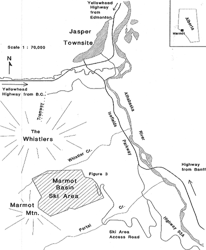
Figure 2: Eagle Ridge Chalet Slopes. Showing Proposed Glading and Ski Runs
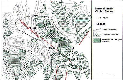
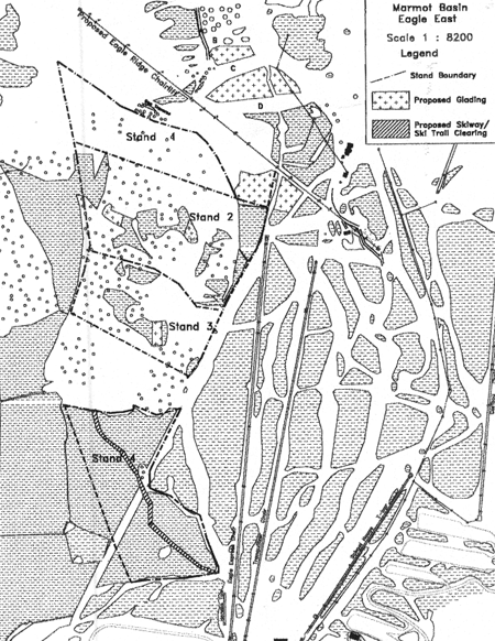
Figure 3: Eagle Ridge, Eagle East. Showing Proposed Glading and Skiway.
INTRODUCTION
This report is presented to provide reviewers an effective overview of the proposed Eagle Ridge project in a format consistent with that used for the main Comprehensive Study Report. It is presented in two parts, each of which has been independently prepared:
Part 1 is a summary of the main Comprehensive Study Report (CSR). This summary report has been prepared by iris environmental systems at the direction of the proponent, Ski Marmot Basin. The assistance and direction of both Parks Canada and the CEAA agency were solicited to ensure the report format and content would address anticipated review needs. It is presented in a manner that is consistent with the guidelines for CSR preparation outlined by the Canadian environmental assessment agency. The summary report provides readers who have not reviewed the main CSR report with a necessary context for considering the Part 2 report, a "sufficiency" analysis prepared by Parks Canada.
For full details and discussion of all aspects of theCSR, readers are referred to the main report, copies of which may be reviewed at Parks Canada and CEAA agency regional offices, or by contacting the Banff office of Iris Environmental Systems at (403) 762-3166.
Part 2 is an analysis of the sufficiency of the main comprehensive study report, including a determination of the "significance" of identified environmental impacts. Dr. Bruce Leeson, head of the Environmental Assessment Sciences Division of the Western Region of Parks Canada, prepared this report in a manner independent of the proponent and of Iris Environmental Systems.
For further details about the "sufficiency" analysis, readers should contact dr. Bruce Leeson directly at (403) 292-4438.
PART ONE: SUMMARY OF COMPREHENSIVE STUDY REPORT
1. Objectives
The proponent, Ski Marmot Basin, proposes to develop a chairlift and ski runs on Eagle Ridge at the Marmot Basin Ski Area, Jasper National Park. The proposed development will include:
- A fixed grip quad chair with a capacity of 1,744 skiers per hour, comprising upper and lower terminals and fifteen supporting towers;
- Three cleared ski runs (B, C and D), a skiway or traverse (A) and forest glading on the Chalet Slopes with glading and a skiway on Eagle East;
- An improved parking management system, optimising the use of existing parking lot surfaces and associated infrastructure improvements (primarily electrical power supply and distribution).
2. Background
The ski area is located 21 km. south of Jasper Townsite in Jasper National Park, Alberta, Canada (Figure 1). It occupies 693.8 hectares of leased land on the northeast section of Marmot Mountain, in the Trident Range of the Canadian Rocky Mountains. Eagle Ridge is an alpine and upper subalpine peninsula-shaped ridge on the southern flank of Marmot basin, itself a Northeast-facing cirque basin situated between 1600 and 2600 m. in elevation. Eagle Ridge is within the ski area's leasehold boundary. The Eagle Ridge ski pod comprises the Chalet Slopes on the west side of the ridge (Figure 2); Eagle East to the east (Figure 3); and a portion of the ski terrain within the Thunder Bowl to the southwest.
The ski area's present comfortable carrying capacity has been determined to be 3,401 skiers per day. Existing lifts operate at 50% of their design capacity on days having 3,000 skiers. The ski area's comfortable carrying capacity will increase to 3,506 skiers per day with the development of a fixed grip quad chairlift on Eagle Ridge, well within the limit of 6,500 skiers per day established in the 1981 Long Range Plan of Record. Doppelmayr Lifts Ltd. of Kelowna, B.C, has prepared a lift design and profile. Field research has been undertaken by a team of experienced scientists to map resources; to identify and assess potential impacts; and to recommend modified design parameters and mitigations that will reduce or obviate potential impacts.
The development of new chairlifts and new ski runs in National Parks requires assessment at the Comprehensive Study level of C.E.A.A. This assessment includes examination of the project's potential for site specific, regional and cumulative impacts. Parks Canada has issued Terms of Reference to guide the proponent and its team of consultants in the preparation of the Comprehensive Study Report (CSR). These Terms of Reference were reviewed by key stakeholders and can be found in the CSR. A local, regional and national program of public consultation has been carried out that has led to a number of additional measures for resource protection.
The ski area proposes to develop three ski runs and a ski-way on the Chalet Slopes portion of Eagle Ridge. These runs will carry skiers downhill to the Basin Run. A skiway (collector run) is proposed at the base of the Eagle East ski terrain, giving access to the Caribou Chalet. Eagle Ridge comprises an area of natural and gladed skiing. This skiway will also be used for the evacuation of injured skiers and riders.
To minimize tree removal, forest glading is proposed on both the Chalet Slopes and on Eagle East. On Chalet Slopes, 2.3 ha. will be impacted by ski run and lift line development, while 3.56h. will be gladed. On Eagle East, 0.38 ha. will be cleared for a skiway, with 0.48 ha. gladed.
The design specifications of the proposed chair lift are as follows:
Ski runs, the lift line and skiways will require complete removal of trees and shrubs. Ski glades will be selectively thinned to simulate open forest glade skiing. No additional surface parking areas will be required for this project. It is recommended that revised parking management procedures be implemented to improve the utilization of existing surface parking lots.
3. Purpose
The purposes of this project, as defined by the proponent, are as follows:
- To improve the quality of the ski experience at the Marmot Basin ski area to maintain market share in the face of growing and direct regional competition;
- To respond to the expressed desire of repeat skiers by developing attractive new ski terrain and a quad chairlift on the upper mountain; and
- To improve access to intermediate and expert ski terrain not readily accessible from the area's existing lift system.
4. Alternatives
A full discussion of alternatives can be found in the main report. In summary, those considered were:
a. Undertake no development of ski terrain or chairlifts at Eagle Ridge for the foreseeable future;
Rejected by the proponent for the following reasons:
- Eagle Ridge development specifically approved in the long-range plan of record;
- Optimisation of an important component of the ski area's terrain mix (25%) urgently needed;
- With the Plan of Record only partially implemented, facilities and infrastructure are unbalanced;
- Competitive position of the ski area may decline with resulting loss or erosion of winter tourism in Jasper;
- Ski area guidelines review may involve long delays.
b. Undertake an alternate development within the ski area;
The project team identified three possible alternate developments:
- Consolidate Lifts on Caribou Ridge,
- Upgrade/Replace School House T-Bar and Teaching Terrain, or
- Upgrade Out of Base Capacity.
This alternative was rejected for the following reasons:
- These developments are not identified in the Ski Area's Plan of Record
- These developments do not meet the goals of the Ski Area at this time.
c. Select an alternative alignment or select a different form or design of lift for the Eagle Ridge ski pod;
The project team used the following criteria in the design of Eagle Ridge Chairlift:
- Avoidance of environmentally sensitive sites;
- Ease of access to and egress from the proposed chairlift;
- Minimization of aesthetic impacts due to chairlift visibility to National Park visitors and wildlife;
- A safe, high quality, low maintenance, base driven chairlift in balance with the available ski terrain and in support of the business and marketing goals of the proponent.
The proposed chairlift alignment minimizes environmental impact while maximizing chairlift effectiveness using the proposed alignment and design.
d. Delay development at Eagle Ridge pending revision of the Plan of Record (1981).
The benefits and drawbacks for this alternative are the same as those for alternative "a".
The potential environmental impacts of each alternative are described in the main report. Potential impacts are the least for projects that occur within the ski area's presently developed footprint.
5. Relation to the Plan of Record
The ski area's ministerially approved 1981 Long-Range Plan of Record specifically identifies Eagle Ridge as a potential development site. It identified the following development conditions:
- "An ultimate capacity of 6,500 skiers is proposed within acceptable levels of environmental impact, respecting the natural attributes of the National mountain resources and assisting in the appreciation of those resources through facility placement, noise suppression and liaison with the interpretive services of the park naturalists."
- "Important or fragile environmental resources which would be impaired by ski area development have been identified on the upper slopes of the Marmot cirque from Eagle Ridge around to and including, Caribou Ridge. Any lift proposals that would ease the present difficulty for humans to gain access to any place on the Marmot Mountain skyline will constitute an unmitigable impact for goats and caribou."
- "Construction of lifts must be undertaken with special techniques such as helicopters, as past construction of access roads has created the most serious residual environmental impact situations at Marmot Basin. Lift development in Thunder Bowl and skiing off the back of Eagle Ridge must be undertaken so as not to disturb the saturated soils and the stabilizing willow vegetation which occurs there."
- "Marmot ski area is located in a vicinity of Jasper National Park where extensive scenic viewing and photography of panoramic mountainscapes from the peaks of Whistler Mountain occurs. It is especially important that the highest valued visitor objectives for travelling to Jasper National Park not be compromised. Development of lifts, runs or other physical changes to permit skiing into the presently undisturbed Whistler Creek valley is unacceptable."
The 1986 Initial Environmental Evaluation identified neither significant environmental impacts nor specific resource protection measures in association with the Eagle Ridge Chairlift proposal. It did however specify that detailed construction plans and site-specific environmental assessment would be required prior to project initiation. CEAA has become the vehicle for that site-specific review.
6. Proposed Capacity Increases
The following changes to capacities will result from the approval of this project:
| Facility | Present | Proposed |
|---|---|---|
| Lift Capacity | 4764 | 5441 |
| Comfortable Carrying Capacity | 3401 | 3506 |
| Car and Bus Parking Capacity | 4771 | 5526 |
The development of the proposed facilities on Eagle Ridge will increase the comfortable carrying capacity of the Marmot Basin ski area from 3,401 to 3,506 skiers/day. This is within the limit prescribed in the plan of record.
7. Schedule of Proposed Development Activities
Two possible construction schedules are presented. (The applicable schedule is dependent upon the date of development approval.) In the event that approval is granted beyond the date when manufacturers can provide lifts, a two-year construction process will result.
8. Ski Run and Forest Glading Design
Ski Runs were designed to follow the following criteria:
- Ski trails through wooded terrain must follow a fall line (trails that cut across a fall line are awkward to ski and difficult to groom);
- Each trail must provide a reasonable route from a lift unload to a lift load point.
- Trails should be attractive throughout their length to one class of skier.
- On either side of the trail, a strip of undisturbed forest should remain that is at least as wide as the trail itself.
- Avoiding trails that egress into the back of a lodge.
- Selecting locations for intersections between the new and older trails that will minimize congestion and crossing traffic problems.
- Taking advantage of natural clearings and glades to minimize the volume of timber to be removed.
Forest glading has been proposed on both the "Chalet Slopes" and "Eagle East" ski terrain. Forest glading is a relatively low impact means of providing expert skiing, while avoiding clear-cutting associated with more traditional methods of ski run development. It provides access to high adventure and challenge on terrain not used by skiers of lower skill levels. Another advantage is that availability of such terrain reduces the demand expert skiers place on groomed runs provided for beginner and intermediate skiers, thereby reducing conflicts and collision risk. Factors taken into consideration when designing the gladed areas for this project include:
- Trees removed for glading are selected to maintain the species and size class structure of the original forest stand.
- Ski terrain is gladed to simulate a mature, open forest.
- Spacing for glades will average 5 metres. Natural glades exist 2 to 20 metres wide, with much variation in that range;
- The gaps between successive clumps of trees should be offset, so that there are no extended straight lanes. Long straight lanes may trap skiers into going too fast;
- Clusters of trees should be kept small so that as much terrain as possible is skiable;
- Semi-standing dead trees and snags that provide habitat for cavity nesting birds and insect feeders will be protected where safety concerns can be assured;
- Trees should be either entirely removed, or untouched. Removing only the lower limbs to create an opening should be avoided;
- Close to the tree line, trees often grow in tight, mutually dependent clumps, known as krüppelholz (literally trees that have been crippled and twisted by wind and weather). Krüppelholz clumps should be left intact;
- Forest should be left untouched in areas where skier traffic is to be discouraged, such as the areas at the top of dangerous cliffs and routes that will lead to congested traffic areas;
- Glading should not materially increase the frequency of avalanches in existing paths, increase the run-out of existing paths, or create new paths;
- Seepage sites in closed forests should not be developed as glades by added tree removal; and
- No white-bark pine will be removed.
9. Tree Removal
Westwood Fibre (Alberta) Ltd., Registered Professional Foresters planned tree removal and assessed tree merchantability for the project. Net value was ascertained through average pricing of logging and the value of logs loaded on the truck paid by local mills as equal to or less than zero. The total number of trees proposed for removal was determined through sampling surveys performed on site. A total of 1318 trees will be removed from Eagle East, and 2234 from Chalet Slopes. Of these, 124 have dbh>24 cm.
All vegetation will be flush cut by hand crews using chain and brush saws. Trees and shrubs will be cut low to the ground and bucked into four-foot lengths. Stumps will be removed only on the Eagle East Skiway should cuts and fills be required. Merchantable logs will be heli-logged out of the project area, while non-merchantable timber >15-cm. diameter will be bucked for firewood. All other brush will be collected and burned on a site approved by Parks Canada.
10. Excavation Methods
Construction has been scheduled during the late summer and fall, and/or during winter months to minimize disturbance to wildlife and vegetation. This will also permit construction to avoid periods of high ground moisture and to allow equipment and materials to be moved over snow. Excavation of foundations will be by tracked excavator, walking hoe or by hand crews as appropriate. Appropriate measures will be taken to minimize impact of equipment on vegetation and soils during the excavation, construction and reclamation stages. Helicopters will deliver concrete and lift components where required.
Terrain modification will be required only in the vicinity of the lower terminal and associated maze, and at the junction of Basin Run and Run D. Contingency Plans have been drawn up to deal with construction waste, garbage and food handling, project permit requirements, traffic, site security, workforce accommodation, disturbance to park visitors, safe storage of fuels and hazardous materials, spill containment, erosion control and safety issues.
11. Valued Ecosystem Components
In its description of the resources of the Marmot Basin ski area; the main CSR considers ecosystem, community and social, and infrastructure components of the proposed project. For the sake of brevity, this summary will concentrate only on those factors that are identified as valued ecosystem components, and thus requiring special study, mitigation and protection. These components have been identified as:
- Silt rich glacial tills, prone to wasting when saturated. If disturbed, these materials may flow or move in rotational blocks. For this project, the lower terminal and towers 1 and 2 are situated within the depositional range of these tills. Geotechnical surveys have been conducted at the proposed lower terminal to ensure adequate foundation design.
- On the proposed lift line, between tower site 5 and tower site 13 and on the mid to upper portions of runs B, C and D, are plant communities with abundant cover (up to 90%) and diverse terricolous, particularly fruticose, lichens. Peterson et al. (1995) noted that there is evidence to suggest great age for these alpine lichen-heather communities at higher elevations. These communities have been identified as locally (and possibly regionally) botanically significant (Wilkinson and Williams 1998), Achuff (1998, pers. comm.) and Timoney (1998, pers. comm.). In the proposed development area they occur on moderate to steep north- and west-facing slopes with sparse tree cover and regeneration of Engelmann spruce and subalpine fir. These lichen-dominated communities are sensitive to disturbance, small in extent and appear to be restricted to this area and Caribou Knoll in the Marmot Basin Ski Area lease.
- Below the proposed lower terminal and the road to the Paradise Chalet and on the lower portions of runs B and C are seepage sites with organic soils and surface to sub-surface water flow. Willows, such as smooth willow and Barratt's willow, are present as a shrub layer at some lower elevation sites while many others lack shrubs. Abundant mosses, and an herbaceous layer with vascular plants characterize all of the seepage communities. These sites are not considered botanically significant but are sensitive to disturbance.
- Nine vascular plants classified as provincially rare (Gould, 1999) and three species currently on the ANHIC watch list were observed in the Eagle Ridge development study area. The primary focus of this vegetation study was on vascular plants. Where species of non-vascular plants were known, they were noted. No mosses known to be provincially rare were noted in the study area.
- Woodland caribou must be considered threatened throughout their range in Jasper National Park. A drastic (50%) population decline has occurred during the past two decades. Although no single cause of their decline is known, protection of caribou and of critical habitat is an obvious priority. Caribou populations are considered stable to declining.
- Mountain goat and grizzly bear are resources of particular value. The Marmot Basin Ski Area contains mountain goat habitat, including a mineral lick newly identified last year. Grizzly bear, while occasional visitors, are resources of value. The special protocol that has been adopted to avoid disturbance for these magnificent animals is testimony to the importance the ski area ascribes to their importance.
The following table lists potential impacts, suggested mitigations and possible residual impacts to the valued ecosystem components due to the proposed project: Criteria used in the table are defined below:
- Nature of Impact: The nature of specific impacts on theVEC.
- Magnitude:
- A negligible effect is an interaction that may not require mitigation.
- A minor effect is an interaction that requires mitigation (if adverse) and affects a population or resource at a local level but does not threaten the integrity of the population, does not alter any physical feature of recognized significance or does not alter land use over the long term.
- A major effect is an interaction that requires mitigation (if adverse) and affects a population or resource at a widespread or regional level, threatens the integrity of a local population or resource or any population depending on it, alters a physical feature of recognized significance or alters land use over the long term.
- Direction:
- A positive environmental impact is an interaction that enhances natural resources, features or existing land use within the study area.
- An adverse effect diminishes natural resources or features or diminishes existing or potential uses of land within the study area.
| Soils and Landforms | |
|---|---|
| Nature of Impact: | Potential damage to soils and permafrost lenses. |
| Magnitude: | Negligible |
| Direction: | Adverse |
| Mitigations: |
|
| Residual Effects: | None |
| Proposed Lift Line and Terminals | |
|---|---|
| Nature of Impact: |
|
| Magnitude: | Minor |
| Direction: | Adverse |
| Mitigations: |
|
| Proposed Ski Runs | |
| Nature of Impact: |
|
| Magnitude: | Minor |
| Direction: | Adverse |
| Mitigations: |
|
| Gladed Areas | |
| Nature of Impact: |
|
| Magnitude: | Minor |
| Direction: | Adverse |
| Mitigations: |
|
| Residual Impacts on Vegetation: |
Recommendations have been made to minimize potential adverse impacts to environmentally sensitive areas such as seepage sites and terrestrial lichen-dominated communities. The footprint of the facilities: fifteen 7m2 tower pads and two terminals that total 64 m2 in size, plus the maze (1050 m2) and road realignment (1480 m2) is relatively small in relation to the size of the ski area. Ski runs have been sited in areas with relatively low tree cover and therefore the proposed development will not result in a substantial loss of trees. Removal of trees and brush on 2.68 ha for ski runs and lift installation and from forested strips within a 4.03 ha area that will be used for gladed tree skiing. Tree removal will affect 7.6% of the area within the Eagle Ridge pod. In total, approximately 3,552 trees should be removed - 3,428 with a diameter of 4 - 24cm. and 124 with a diameter of 24cm or greater. 702 lodgepole pine, 1,920 white spruce and 930 subalpine fir will be removed. As described in Section 3 of this report, there will be some loss of Engelmann spruce and subalpine fir from seedling to mature tree size at some proposed tower sites, the lower terminal and on sections of the proposed runs. These species comprise the dominant tree cover in most of the lower subalpine and upper subalpine areas and are very common in the Marmot Basin Ski Area and in Jasper National Park. Some changes will likely occur in microhabitat conditions after tree clearing and subsequently in species composition and abundance in the understorey of these vegetation communities (as described in Section 3 of this report). Most of the understorey plants that will be affected because of development are common in the study area outside of areas proposed for disturbance. Mitigation suggestions have been proposed to avoid or minimize impact on the three rare species one-headed everlasting, ground fir and Lapland reed grass that appear to be very uncommon in the Marmot Basin Ski Area. The removal of trees and slash from ski runs and gladed areas will have the following potential negative residual impacts:
The removal of trees and slash from ski runs and gladed areas will have the following potential positive residual impacts:
In the Alpine zone, woody vegetation is very slow to break down. Very old, dry wood can increase fire hazard. |
For a full discussion of impacts, mitigations and residual effects of all factors including valued ecosystem components please refer to the CSR.
12. Cumulative Impacts and Net Negative Environmental Impacts
The cumulative effects assessment process entails the identification of potentially sensitive heritage resources within the zone of influence of a proposed project and the evaluation of the impact of the proposed project in the context of stated temporal and spatial boundaries. In the case of the proposed Eagle Ridge development, the following criteria were used in the consideration of potential cumulative impacts:
The focus of concern for cumulative impacts is on the effect that potential vegetation change may have in reducing grizzly bear and caribou habitat. The effect of past, present and future developments has shaped grizzly bear and caribou habitats, reducing the effectiveness of grizzly bear habitat units in the Athabasca Valley near the Hamlet of Jasper.
Most developments within Jasper National Park have been restricted to lower elevations, particularly within the confines of the Athabasca Valley and its principal tributaries. The Yellowhead Highway; the Hamlet of Jasper (Jasper Townsite); the Icefield Parkway; most commercial accommodations and services; and National Park frontcountry campgrounds, trails and picnic sites are all located within the floor of the Athabasca, Miette and Sunwapta Valleys. The influence of these developments on grizzly bear habitat is summarized in the draft Jasper National Park Management Plan. The number and scale of visitor facilities in and around the Hamlet of Jasper significantly reduce the potential value of adjacent habitats for grizzly bears. Bears come into potential contact and conflict with humans as they descend to lower elevations during spring green-up, and throughout the summer as they cross highways and roads to more remote visitor facilities and destinations such as Maligne Lake, Miette Hot Springs, and the Tonquin Valley via the ski area access road or the Edith Cavell road. By mid-summer, most grizzly bears begin to move to feeding areas at higher elevations, although being very mobile, they will return to areas rich in berries or other preferred foods. Although rated by COSEWICas a vulnerable species, the grizzly bear population in Jasper has remained stable for the past several decades.
Future projects at the ski area and elsewhere within Jasper National Park do not have the potential for significant additional alterations to grizzly bear and caribou habitat. To the contrary, our knowledge of the ecological requirements of these species is increasing and will improve awareness of the potential impacts of human activities and facilities in the Rocky Mountain National Parks. Measures initiated by Parks Canada will improve the focus of park management in directions more supportive of wildlife habitat protection. Changes to legislation and policy will support this direction.
The Eagle Ridge project does not trigger any additional development at the Marmot Basin Ski Area, nor elsewhere within Jasper National Park. This project is consistent with and does not alter the general direction of the approved Long Range Plan. Future development at the ski area will be in the form of discrete projects that have prior approval in an approved long-range plan.
Most of the project's potential direct environmental impacts can be effectively mitigated. Additional visitation that can be attributed to the project can be readily accommodated and served by existing visitor facilities and services at the ski area and in Jasper Townsite. The Eagle Ridge project can be serviced without expanding community and ski area service infrastructure and without limiting the opportunity for future ski area developments to proceed.
For the five to ten year planning horizon, growth in skier attendance will be at a conservative pace. To provide a high quality of experience, developments at the Marmot Basin Ski Area will be staged at considerable intervals. The focus of future development will be to improve the skier experience within the presently used footprint.
No expansion of National Park visitor facilities is anticipated within the immediate environs of the ski area. Improved management of human use will enhance, not degrade habitat capability for species of high value including grizzly bear and woodland caribou, both of which are listed as vulnerable by COSEWIC.
Further expansion of facilities within Jasper Townsite and outlying areas will be sharply curtailed and subject to legislative limits. Future development at the Marmot Basin Ski Area will be guided by the Long Range Plan and by guidelines in preparation by Parks Canada. Expansion of commercial visitor facilities is not required to support projected skier attendance growth at the Marmot Basin Ski Area. The capacity of facilities, including accommodation and restaurants, can meet the projected needs of ski area visitation for the planning period.
By directing as much of the construction activity as possible to the winter months, the potential for impacts to wildlife will be minimized. Timber removal and foundation work for the upper lift terminal and for eight of the 15 towers can be completed during the winter months using over-snow construction methods applied successfully at the Sunshine Village ski area during the construction of the Goat's Eye Chairlift. Implementation of a protocol to avoid the risk of disturbance to, or encounters with, grizzly bears will reduce the potential for impacts that result from recurring disturbance.
Winter use of Eagle Ridge and of un-built elements of the Long Range Plan, have no potential impact on habitat effectiveness models being developed by Parks Canada.
Net Negative Environmental Impacts
In addition to undertaking cumulative impact assessment, this report must also consider the application of the Heritage Minister's policy, announced in June of 1998, requiring that developments in Canada's National Parks have "no net negative environmental impacts". Specific criteria for weighing the residual impacts of a project and for balancing them against possible environmental benefits and compensations to determine a "measure" of a project's net environmental effects have not been determined by Parks Canada. Net environmental impacts are best determined and assessed at the level of the ski area leasehold. Maintaining a "no net negative" policy will be most effectively achieved on a strategic basis as long-range plans are reviewed and updated.
For purposes of this report, negative environmental impacts are interpreted as the direct or cumulative effects of the project that have the potential to cause significant loss or disturbance to ecosystem resources. Although Parks Canada has the final authority to determine the potential significance of the effect(s) of projects within National Parks, no potentially significant direct or cumulative impacts have been identified by the project team for the proposed development of a chairlift and ski runs on Eagle Ridge.
13. Public Consultation
The following are highlights of the pubic input process and responses:
- Over 3,423 individuals and groups across Canada were identified on the mailing list and sent information packages about theCSR. This information package included a copy of the Information/Comment sheet, notice of where to view the report and how to get involved in the process.
- Of the individuals on the mailing list, 1,016 or 29.6% were local (Jasper and Hinton), 2,194 or 64.0% were regional (rest of Alberta and British Columbia), 183 or 5.3% were from the rest of Canada and 30 or 0.8% were international.
- A total of 107 individuals, including 6 media representatives, attended the open houses. Media coverage was minimal.
- The news release was distributed to over 150 media and stakeholders across the country. Paid advertisements were placed in national and local media. Reminder notices were faxed to local media prior to the open houses and telephone contacts were made. Flyers about the open houses were posted locally in Hinton and Jasper and local and regional MLAs and MPs were advised of the times and locations.
- A total of 126 completed Comment sheets were returned from the more than 3,423 distributed, a response rate of 4%. The majority of responses were from the local area (39 or 30.9%) and regional area (80 or 63.4%). Only three (2.3%) were from national respondents. Four (3%) did not acknowledge their name and address.
- Of the 126 completed Comment sheets, 85 (67.4%) were in favour of the project, 27 (21.4%) were opposed to the project and 14 (11.1%) were undecided.
- The 23 key stakeholders, identified in the fall of 1998, were sent full copies of the report and Information/Comment Sheet in early June 1999. Representatives from 13 of the key stakeholders attended open house sessions.
- Completed comment sheets from representatives of 5 key stakeholder groups and 3 formal submissions (Jasper Environmental Association, Canadian Parks and Wilderness Society and Bow Valley Naturalists), representing 5 other key stakeholder groups, were received. Written responses were made to the comments and concerns presented in the three formal submissions and revisions have been made in this CSR, as appropriate.
- Eleven key stakeholders expressed orally that they either have no concerns with the project or that they have concerns regarding the restrictive policies governing ski areas in National Parks. Comments related to policy issues have been forwarded to Parks Canada.
- Comments were received from several government reviewers and written responses to these have been prepared and incorporated in this report, as appropriate.
The following two tables summarize responses to the public consultation process:
14. Aboriginal Interests
Aboriginal Interests are not affected by this development. No native lands lie adjacent to the ski area and no archaeological resources are known to lie within its boundaries.
15. Environmental Management
The ski area's team for project management includes: Dave Gibson, Vice President; Damon Kolawachuk, Mountain Operations Manager; David Day, Project Manager, Iris Environmental Systems, Banff Office.
All of these people have direct experience in the design and installation of chairlifts and the clearing of ski runs. All are familiar with the range of mitigations and rehabilitation procedures specified.
Environmental project Surveillance will be provided by the ski area and IRIS in consultation with the Parks Canada Ski Area Coordinator. Periodic surveillance will be provided by Ski Area Planner Jim Buckingham and Iris project staff on a basis to be planned prior to construction.
16. Environmental Benefits
Avenues for realizing potential environmental benefits from the proposed project include:
- Increasing the communication of heritage-based messages in marketing and sales materiel and programs to promote increased awareness and support for park conservation values. At the ski area, heritage awareness messages will be placed in lodges as displays. interpretive panels, and signage.
- Expanding appreciation for cultural heritage. The rich cultural history of the area is intrinsically tied to alpine climbing and skiing. These messages will also be communicated to skiers using the media described above.
- Increasing habitat diversity in closed spruce-fir forests within the ski area that are otherwise essentially isolated from change agents such as fire. Although the potential impact of vegetation change on species classified by COSEWICas rare or endangered must be considered, vegetation change through ski run clearing and forest glading will have the effect of increased plant community diversity and this increasing wildlife habitat diversity.
- Increasing knowledge about wildlife habitats and movements. This project has already contributed to our knowledge of the National Park ecosystem, including locating a new mineral lick location in the Whistlers Creek drainage.
- Increasing scientific knowledge and understanding of the impacts of skiing and snow compaction on plant communities in the upper subalpine and alpine life zones. Future monitoring and research projects supported by the four National Park ski areas will provide information to improve our understanding of, and enable park managers to reduce threats to the ecological integrity of national park resources.
- Increasing sustainable opportunities for appreciation and enjoyment of Canada's National Park heritage.
17. Contingency Planning
The following contingency planning measures will be implemented:
- This project would be spread over a winter and summer season, reducing the risk that inclement weather would cause delays that may put ecosystem resources, materials or people at risk.
- Using tidy tanks and spill pans will mitigate the risk of fuel spills. Absorbent material will be stored at each staging area for immediate application. Spill kits will be kept at all active work sites. Procedures for notifying Parks Canada are well established and will be strictly observed.
- The ski area will designate an Environmental Surveillance Officer to co-ordinate field surveillance and communication between Parks Canada, contractors and the ski area administration. Liaison would be maintained with the Parks Canada Ski Area Co-ordinator and Surveillance Officer. Both of these individuals have the authority to issue stop work orders, or to modify field procedures to protect natural resources or assure public safety.
- Fire prevention and response will be provided through the ski area's existing fire protection system.
18. Knowledge Deficiencies
No critical knowledge deficiencies were identified during this process leading to the completion of the CSR, however a number of monitoring programs are recommended and set out below.
19. Follow-up and Surveillance Requirements
A series of projects to monitor changes to vegetation communities will be established in consultation with Parks Canada for sites representing plant communities deemed at risk. Baseline information will be gathered in the summer preceding construction and monitored at intervals to be agreed between Parks Canada and Marmot Basin Ski Area. It is suggested that monitoring take place annually or bi-annually for at least 10 years after development. The precise details of the monitoring program will be developed on a species and site-specific basis in consultation with Parks Canada representatives. Projects will monitor:
- The impact of skiing, grooming (using permanent photo plots and/or quadrat sampling) and tree removal on sensitive vegetation including the terrestrial lichen-dominated communities and in seepages. The viability of reindeer lichen mats in particular will be monitored in the long term to determine the effect of increased insolation levels and increased skiing and grooming activities
- The impact of skiing, grooming and tree removal on vegetation communities that have been recorded to include existing rare plant species.
- The impact of skiing, grooming and maintenance mowing on convex slopes and hummocky terrain that is prone to scalping and shearing so that appropriate action can be taken to prevent further damage when required.
- The establishment and long term success of any transplanted and/or re-seeded rare plant species.
- The success of re-vegetation efforts surrounding tower pads and terminals using plant density and/or cover techniques.
The Marmot Basin ski area will continue to promote and support research into the movement and habits of wildlife within the ski area boundaries, encouraging the monitoring of large carnivores, woodland caribou and mountain goats within its lease to determine the nature and extent of impacts from its operation on those species and the most effective means of mitigating those impacts.
An avifauna survey was conducted as part of this project. Pick (1997) has recommended that a regular Breeding Bird Survey Program, including owl surveys, be set up in Jasper National Park, including the Marmot Basin Ski Area and supported by SKI MARMOT BASIN.
Cuts and fills may be required on the Eagle East collector skiway. Should this prove necessary, Parks Canada permission for that project would be sought after all required procedures have been followed.
20. References
For a listing of all references, please refer to the mainCSR report. Contact IRIS Environmental Systems by fax at (403) 762-8786 for information on how to gain access to a copy of the main report.
The following references apply to this summary report:
- Achuff, Peter, 1998. pers. comm. Conservation Biologist. Jasper National Park.
- Gould, Joyce. 1999. Plant species of special concern. Alberta Natural Heritage Information Centre. Alberta Environmental Protection, Edmonton, AB.
- Leeson, B.F. 1986. Initial Environmental Evaluation. Marmot Basin Ski Area Long Term Development, Jasper National Park. Environment Canada - Parks. Calgary, AB. 148pp.
- Marmot Basin Ski Area. December 1981. Long Range Proposals
- Peterson, E.B., Peterson, N.M. & K.A. Enns. 1995.Guidelines for old growth forest management in Elk Island,Jasper, Yoho, Kootenay, Banff and Waterton Lakes National Parks. Western Ecological Services Ltd. and Larkspur Biological Consultants, Victoria B.C. Unpubl. Report for Canadian Heritage, Parks Canada, Alberta Region.
- Pick, D. 1997. Avifauna Survey of Marmot Basin Ski Area, Jasper National Park, AB.
- Timoney, Kevin. 1998. Pers. Comm. Environmental consultant, Sherwood Park.
- Wilkinson, Kathleen and Joan Williams. 1998. Vegetation and flora of Marmot Basin Ski Area: management implications for future ski area development. Unpubl. Report prepared for Parks Country Environmental Consultants. Banff.
Parks Canada Review ofComprehensive Environmental Study, A Proposal to Develop a Chairlift and Ski Runs on Eagle Ridge, Marmot Basin Ski Area, Jasper National Park, December 10, 1999
The owners of Ski Marmot Basin have proposed to construct a quad chair ski lift and associated ski runs on Eagle Ridge at the Marmot Basin ski area in Jasper National Park, Alberta, Canada. This proposal triggered a Comprehensive Study, pursuant to the Canadian Environmental Assessment Act (1992) (CEA Act ) and its' attendant Regulations. The project proponent is Rocky Mountain Skiing Incorporated, operating as Ski Marmot Basin. Parks Canada is the Responsible Authority for review of the proposal; Environment Canada provided expert advice. The following is Parks Canada's review and conclusions regarding the appropriateness of the proposal and the adequacy of the Comprehensive Study. Finally, a preliminary determination is rendered regarding whether or not the project is likely to cause significant adverse environmental effects, taking into account mitigation measures.
At this point in the environmental assessment review process, this document is referred to as Parks Canada's "sufficiency review". The Canadian Environmental Assessment Agency conducts the next step of review of this Comprehensive Study.
Appropriateness of the Proposal
The National Parks Act (1988), the approved Jasper National Park Management Plan (1988), the Jasper National Park Management Plan Concept (1999) - that is the 'draft' management plan update, the Marmot Basin Ski Area Long Range Plan Proposals (1981) - now referred to as the "Plan of Record", the Marmot Basin Ski Area Initial Environmental Evaluation (1986), the lease between Her Majesty in Right of Canada and the owners of Marmot Basin, and the Interim Guidelines For National Park Ski Areas (April 26, 1999) are the authoritative references to determine the appropriateness of the proposed project.
Parks Canada conducted an examination of the project concept at an early stage in the proposal. At that time it was concluded the project being contemplated was consistent with the National Parks Act, the approved Jasper National Park Management Plan, the 'draft' Jasper National Park Management Plan update, the Plan of Record for Marmot Basin Ski Area and the lease. Subsequently, the project proposal has been developed without substantial deviation from the original concept. The details of the project and the environmental analysis have responded to the concerns expressed in the Initial Environmental Evaluation. Similarly, the project has been analyzed and determined to adhere to the Interim Guidelines For National Parks Ski Areas.
Accordingly, it is concluded the project is an appropriate proposal.
Scope of Project
Ski Marmot Basin has described the principal project as the installation of a fixed grip quad chairlift with a capacity of 1,744 skiers per hour, three cleared ski runs, two skiways and forest glading in two proximal locations.
Interdependent projects - that is, other projects which are necessary to successfully achieve the objective of the principal project - are; a revised parking management plan, infrastructure improvements including electrical power supply and distribution, water supply, sewage treatment, and realignment of an existing work trail. No linked projects - that is, related projects which are made inevitable by the principal project - were identified. Also, undertakings in relation to the physical works of the project have been described, e.g.; snow grooming, avalanche control, out-of-bounds marking and staff accommodation.
The proponent describes the need for and purpose of the project. Early in the development of the project proposal the proponent considered, and describes in the Comprehensive Study Report, alternatives to the project and alternative means of carrying out the project, including; undertake no development, undertake an alternative development within the ski area, select an alternative alignment or a different form or design of lift for Eagle Ridge, and, delay development at Eagle Ridge. The proponent presents technical, economic and environmental rationalization to validate their preferred alternative, which subsequently was advanced as the project proposal at review.
Parks Canada is satisfied the elements of Scope of Project anticipated by the CEA Act have been met in the Comprehensive Study of the Eagle Ridge chairlift and ski run project proposal.
Scope of Factors
Parks Canada prepared a draft Terms of Reference Design Proposal and Environmental Assessment Eagle Ridge Development Marmot Basin Ski Area Jasper National Park. This terms of reference was revised in several iterations of review by Ski Marmot Basin and their environmental consultants - Iris Environmental Systems, and Parks Canada. Also, public stakeholder input was sought and considered before a final terms of reference was prepared. A final terms of reference was endorsed by Parks Canada and Ski Marmot Basin in November, 1998. This Terms of Reference subsequently guided the preparation of the environmental assessment and the final project proposal.
The terms of reference requires a thorough examination of all the standard elements of an environmental screening of a ski lift and terrain development project in a Canadian national park, as well as the obligatory elements of a Comprehensive Study, as defined in Sec 16(2) of the CEA Act. Also, Parks Canada enhanced the terms of reference with the inclusion of ten special subjects and sensitivities unique to this project and its setting. These include subjects referred to as "Valued Ecosystem Components - VEC's"; such as viewscapes, rare plants, grizzly bears, woodland caribou, Rocky Mountain goats and others. VEC's were to be addressed in detail in the assessment of potential effects arising from the project, and required particular attention in the proposed project design, location and operation. The scope of the factors varies in time and space, depending on the nature of a resource being described and analyzed.
Parks Canada is satisfied the Scope of Factors has been appropriate to satisfactorily assess the potential adverse impact of the project, taking into consideration the mitigation measures proposed.
Description of the Existing Environment
Iris Environmental Consultants prepared the description of the existing environment by reference to an extensive base of resources information, and the conduct of new field studies over a period of two years. In some instances the spatial scale of information gathered is large - such as for transient species, including grizzly bears and caribou, or the extent of ecoregions affected in all of Jasper National Park. Conversely, other topics were site specific - such as soil, drainage and special plants. Topics reported in the Comprehensive Study report included:
- Land Use History
- Climate and Air Quality
- Biophysical Resources Inventory and Mapping
- Geology, Landforms and Surficial Deposits
- Soils
- Vegetation and Plant Communities
- Hydrology and Watershed
- Fish and Wildlife
- Aesthetic and Visual Resources
- Hazardous Natural Circumstances
- Socio-Economic and Community Considerations
- Regional Land Uses and Recreational Facilities
The terms of reference required each of the subjects to be described in detail sufficient and appropriate to facilitate an evaluation of the extent to which the project interacts with, affects, or is affected by the subject. Each subject was to be analyzed to report special constraints and opportunities for the project. Site specific data to determine the resources which would be impacted directly by the physical works was imperative. The scope of factors and depth of study for the factors to be addressed varied depending on the degree of impact of the project on the resource being considered. In some instances, the study and analysis extended well outside the direct footprint of the project. Valued ecosystem components were described and addressed intensely when they were identified.
The ten special considerations highlighted by Parks Canada in the terms of reference were all addressed with more than normal attention.
Parks Canada is satisfied the Scope of Factors was properly defined, and satisfactorily addressed in the Comprehensive Study.
Valued Ecosystem Components
Parks Canada made special note of known valued ecosystem components in the Comprehensive Study terms of reference. These included:
- viewscapes and aesthetic considerations
- sensitive wildlife, their habitats and habitats, particularly for grizzly bears, Rocky Mountain goats and woodland caribou
- any significant plant species and/or vegetation communities which might be discovered.
The Comprehensive Study addressed these subjects, analyzed the project and reported the potential interaction of the project with each of the subjects. Also, the study team scrutinized the area for other valued ecosystem components; no other exceptional subjects or sites were discovered within the scope of this project or assessment.
Viewscapes and appearance of the project were analyzed from short, middle and long distance perspectives. It was found that interactions between the project and visual resource were present, and that mitigation remedies were available.
Rocky Mountain goats and woodland caribou inhabit parts of Marmot Mountain and surrounding terrain suitable for their sustenance. Parts of their ranges overlap. It was discovered that although they only infrequently enter Marmot Basin where the ski facilities are located, they do utilize specialized niche habitats, e.g. - a mineral lick, right on the edge of the ski area. Occasionally goats enter into Marmot Basin, and surprisingly, have approached summer maintenance staff rather closely. Generally however, they are wary, and avoid areas of human activity. Track and scat evidence implies it is probable goats and caribou more commonly traverse the ridge surmounting Marmot Basin, including above the site of the proposed new chairlift and ski runs.
Grizzly bears are very widely ranging species in the mountain national parks. During travels of their range it is probable that most of Marmot Mountain and surrounding valleys and mountains would be investigated and traversed by grizzly bears. This would include Marmot Basin, most of the ski area leasehold, and the site of the proposed lift and new ski runs. Nearly every year, Parks Canada staff and/or ski area staff observe grizzly bear(s) in Marmot Basin. Normally, these are brief sightings of transient bears which are exploring or traversing the area; it is uncommon for a grizzly bear to be present in Marmot Basin for a prolonged period, e.g. - a week. Marmot Basin has never been reported to be a grizzly denning, breeding or cub rearing site. Marmot Basin is not known to be a "hot spot" for extended or seasonally repetitive occupation by grizzly bears.
The findings for highly valued wildlife species, their habits and habitats, are within the range of Parks Canada's observations and expectations for Marmot Basin. Many other wildlife species commonly are seasonally present in and around the Marmot Basin ski area, e.g. - black bear, elk, deer, small mammals and birds. However, other than the above-noted species, there are no wildlife occurrences or habitats which are of exceptional note in the review of this project.
The surprising discoveries occurred with vegetation. In addition to vegetation cover mapping and description, the terms of reference required a rare plant survey. This project transverses the upper subalpine and the alpine life zone on Eagle Ridge, crossing the ecotone. These high elevation life zones (Ecoregions) consistently are considered special and fragile in Canada's National Parks, and there is always the possibility that uncommon plants and plant associations might be discovered there. Eight, and possibly nine vascular plants classified as provincially rare were discovered in the study area by the botanists. Two of these plants, One -headed everlasting, and Lens-fruited sedge are very uncommon, and require special protection. Three other uncommon plant species found within the footprint of the project are on a "watch list" for potential inclusion on the rare plant list in Alberta.
Identification of Potential Adverse Effects and Proposed Strategies to Avoid and/or Mitigate Potential Adverse Effects
The Comprehensive Study authors examined each of the subjects listed in the terms of reference to determine the extent to which the project affected, interacted with, or was affected by the subject. All of the subjects interacted with the project in a way which either gave rise to a mitigation(s) to avoid or reduce effect on a resource, or a design modification for the project. Most of the subjects interacted in a modest way, which required a response within the range of normal design, construction scheduling and techniques, and operational procedures. The mitigation(s) proposed are proven methods, with materials, equipment, knowledge and skills which are commonly available in Alberta. Those subjects which will require these normal techniques of construction and operation of the project include:
- Climate and Air Quality
- Landform and Geology
- Hydrology and Watershed
- Aesthetic and Visual Resources
- Cultural and Paleontological Resources
- Socio-economic and Community Considerations
- Regional Land Uses and Recreational Facilities.
Subjects where potentially adverse effects could arise were; certain species of wildlife, vegetation, disturbed soil reclamation, and drainage at the lower terminal site. To avoid and/or reduce these potentially adverse effects, these subjects and situations necessitated special, mitigation, procedures and strategies, described briefly below.
Bears, both grizzly and black, are identified as species which require special care during the construction of the project. Techniques proposed include winter construction, a written protocal and training for worker response if a bear should approach the work site, work stoppage provisions, limiting helicopter usage, bear repellant methods and worker communication systems. No long term adverse effects are forecast for black bears. Grizzly bears may have reduced crowberry supplies at this site as a result of forest clearing. This possibility has been lessened by minimizing the total area of clearing and glading, and directing this activity to north and east facing slopes which will reduce insolation effects. Also, see the Cumulative Effects section later in this report for further details about this subject.
Impact on caribou and goats will be minimized by prohibiting helicopter flight over their habitat, avoiding direct contact if any goats or caribou should approach the work site, and emphasizing winter construction. As goats and caribou generally avoid Marmot Basin, no long term adverse effects are forecast for goats or caribou.
Parks Canada takes special note that a summer visitor use program is not being proposed. This is a very important aspect of minimizing direct disturbance and alienation of secure habitat for wary wildlife which do enter and use habitat in or close to Marmot Basin during non-skiing seasons.
Minimizing vegetation and soil disturbance is always an important element of construction in a national park. This is particularly critical in the upper subalpine and alpine zones because reclamation is so difficult. In the case of this project, there is the added challenge of safeguarding rare plants. The lower terminal has been relocated to avoid wet soils, and the site of Lens-fruited sedge and Small northern grass-of-Parnassus. Also, it is recognized that care not to disrupt the micro-hydrology of this moist site is imperative to its unique plant community's endurance. Elsewhere along the lift line there is opportunity to shift the position of the towers to avoid rare plants. A botanist will be onsite to assist with final tower placement. In instances where rare plants would be in peril, they will be protected with temporary structures during the construction period, or will be translocated to a suitable nearby site. Oversnow construction and transport of materials will be emphasized to avoid direct surface vegetation contact. Criteria for minimum depth of snow before snow grooming and skiing have been proposed to reduce the possibility of shearing of surface vegetation. An ongoing vegetation monitoring program is proposed to identify any changes which may be required to operating procedures to safeguard special vegetation. Large, woody, slash debris will be removed from the runs, glades, skiways and the lift line and disposed in a specified manner, saving any firewood for use in park campgrounds. Surplus excavated soil will be removed from the construction sites and disposed in an approved manner. A reclamation plan will be formulated for each site of soil disturbance, and implemented promptly to minimize possibility of erosion. The ongoing vegetation monitoring program will identify reclamation follow-up needs.
The Registry Process and Other Federal Government Departments
The Eagle Ridge ski lift and ski runs project was registered in Parks Canada's local Jasper projects environmental assessment file, Parks Canada's national file, and the CEA Agency's National Index. Thenceforth, as the project planning and review advanced, these files were available for public examination. Most of Parks Canada's and the project proponent's information were available in hard copy and electronic form. Some of the technical reference documents were and are held in libraries.
Parks Canada is the Responsible Authority for the federal government pursuant to Section 5 of the CEA Act. Pursuant to the CEA Act Federal Coordination Regulations, on September 3, 1998, Parks Canada forwarded the project outline prepared by Ski Marmot Basin to 17 other federal government departments on the Alberta project referral mailing list. Additionally, Environment Canada and Department of Fisheries and Oceans received the draft Terms of Reference which had been prepared by Parks Canada. Each department was asked to determine and inform Parks Canada if they had;
- A Section 5 trigger under the Canadian Environmental Assessment Act
- Section 12 expert advice
- An interest in the project.
No federal departments other than Parks Canada reported a Section 5 trigger for the project: Environment Canada and Natural Resources Canada offered Section 12 expert advice. Environment Canada, Environmental Protection, Prairie and Northern Region subsequently participated as an expert advisor.
Parks Canada and the proponent have kept in close liaison with representatives of the CEA Agency to receive direction regarding the process of review expected for a Comprehensive Study.
Public Consultation Program, Public Concern and Proponent Response
The first public input regarding a ski lift and runs on Eagle Ridge occurred in 1981. The Eagle Ridge development subsequently was included in the approved "plan of record" which has guided development at the Marmot basin ski area since.
Public consultation for detailed planning and environmental assessment of the currently proposed Eagle Ridge ski lift and ski run project was undertaken in three phases; Pre-proposal Planning, Project Initiation and General Awareness Building, and Public Review of the Comprehensive Study Report. The public consultation program strategy was prepared by the project proponent with Parks Canada's concurrence, but, was largely conducted by the project proponent and their professional consultation consulting company - Strategy Plus. The objectives of the public consultation strategy were:
- To keep interested parties informed about the progress of the Comprehensive Study, and associated design effort.
- To provide a means for interested parties to have input to the Comprehensive Study for the proposed development for Marmot Basin.
- To conduct formal public consultation throughout the process, assess and consider any project modifications as a result of the input, and provide a report on the inputs received and how they were addressed.
- To work cooperatively with Parks Canada and maintain an open and transparent process to meet and exceed the requirements for public involvement for the Comprehensive Study process
- To document and provide an analysis of public comment and summary of the public involvement program to assist Parks Canada in its requirement as Responsible Authority under the CEA Act to evaluate the level of public concern related to this project.
Phase I. Pre-proposal Planning.
Targeted scope public involvement activities carried out in 1997 included:
- Season Ski Pass Holder Survey - 853 dedicated skiers were surveyed at Marmot Basin in the spring of 1997 to obtain their views regarding facilities, services, future development needs and priorities.
- Focus Group Session With Business Community - in July, 1997, Marmot Basin held a session with local business representatives to receive input regarding their perception of development priorities for Marmot Basin, and the opinions expressed by business clients.
- News Release, September 17, 1997 - Ski Marmot Basin announced that future development planning for Marmot Basin was being initiated. The release was distributed to daily and weekly newspapers, and television and radio stations in North-central Alberta and Saskatchewan.
- Personal Interviews - Marmot Basin held personal interviews with 24 business representatives in local communities to determine priorities for development at Marmot Basin and ways to work closely together.
Phase II. Project Initiation and General Awareness Building.
- Public Notice, September 8, 1998 - Parks Canada published a notice in the Jasper Booster that the draft terms of reference for the Comprehensive Study for development of Eagle Ridge at Marmot Basin were available for review and comment. Also, copies of the draft terms of reference were sent to 19 key stakeholders who were identified jointly by Parks Canada and Ski Marmot Basin.
- News Release, September 8, 1998 - Ski Marmot Basin announced their proposal to develop a new ski lift and runs on Eagle Ridge. The news release was distributed to about 298 people, groups, key stakeholders, newspapers, radios, and television stations.
- Stakeholder Briefing and Site Visit, October 15, 1998 - the 19 stakeholder groups who received the terms of reference, and representatives from five other local groups, were invited to a "show me" session at Marmot Basin. Eleven participants, representing five of the groups attended. The attendees were briefed on the progress of design and research, given copies of a fact sheet, shown maps and pictures, received an explanation of theCEAAct and environmental assessment process, and a tour of the project site.
- Public Information and Awareness Building, November 1998 to April, 1999 - Ski Marmot Basin attended local groups meetings to make presentations and distribute fact and comment return sheets. Venues included, the Jasper Recreation and Culture Board meeting, Jasper Tourism and Commerce meeting, Jasper Junior and Senior High School Teacher's Meeting, Hinton Chamber of Commerce meeting, and the Jasper-Yellowhead Historical Museum Society meeting. Also, Marmot Basin maintained a display board at the ski area, and an information website page regarding the project proposal, planning and review.
- Data Base Building/Mailing List Development, November, 1998 to May, 1999 - Marmot Basin developed a mailing list of 3,423 individuals.
Phase III. Public Review of Comprehensive Study Report, June to August, 1999
- Key Stakeholder Contact, June, 1999 - 23 key stakeholder individuals and groups were contacted by phone to alert them the Comprehensive Study, and information/comment sheets soon would be provided directly to them. The information packages were distributed by courier on June 14, 1999.
- News Release, June 10, 1999 - a news release prepared in English and French, was approved by Parks Canada and released on June 10, 1999. It announced the draft Comprehensive Study had been submitted to Parks Canada, and provided dates and locations for four upcoming open houses. The release highlighted locations where the report could be consulted, including a website. This news release was distributed to 150 media outlets and individuals, including print and electronic media, 23 stakeholders and several government departments.
- Information/Comment Sheet to Mailing List/Media - a short Information and Comment Sheet was prepared in English and French. It was posted on the IRIS Environmental Systems website and mailed to 3,423 individuals on the mailing list. It informed readers where the main Comprehensive Study report could be accessed, how to get involved, where and when the open houses would take place, and how to return comments.
- Library Displays, June/July, 1999 - a copy of the Comprehensive Study, Information/Comment Sheets and a free-standing display were maintained at libraries in Jasper, Hinton, Edson, Edmonton, Lloydminster, Grand Prairie, Red Deer, Fort McMurray, Banff and Valemont.
- Briefing Package for Regional MPs and MLAs, late June, 1999 - a package of news releases, the Information/Comment Sheet, and information about open houses was sent to 10 local MPs and MLAs
- Public Open Houses, June/July, 1999 - Ski Marmot Basin and their consultant hosted open houses in Calgary on June 28, 1999, in Edmonton on June 29, 1999, in Hinton on July 6, 1999, and in Jasper on July 7, 1999. Advertisements regarding the open houses were taken in the National Post, Calgary Herald, Edmonton Journal, Jasper Booster, Hinton Parklander, and Le Franco. Open houses provided maps and displays, a continuous slide show, copies of the Comprehensive Study Report and other documentation. Representatives of the study team, Ski Marmot Basin and Parks Canada were present to respond to questions. Sign in sheets and comment sheets were provided.
Highlights of Public Input
- over 3,423 individual and groups across Canada were sent information packages about the Eagle Ridge proposal and the Comprehensive study
- news releases were sent to over 150 media and stakeholders across the country
- a total of 107 individuals, including media staff attended the open houses
- a total of 126 completed Comment sheets were returned from the more than 3,423 distributed
- of the 126 returned Comment sheets, 67.4% were in favour of the project, 21.4% were opposed to the project, and 11.1 % were undecided
- completed Comment sheets from representatives of five key stakeholder groups, and three formal submissions representing five other key stakeholder groups were received. Written responses were made to the comments and concerns presented in the formal submissions, and revisions were made in the Comprehensive Study report, as appropriate
- the proponent has consulted with Parks Canada in responding to public concern, both in reply to commentators, and in modifications to the project
On behalf of Ski Marmot Basin, Strategy Plus has prepared aPublic Consultation Process Report and Iris Environmental Systems prepared a Summary of Participant Comments and Consulting Team/Proponent Responses.
Parks Canada has undertake an analysis and audit of the public consultation program conducted by Ski Marmot Basin and their consultants. Parks Canada concluded the public involvement program undertaken has fully achieved the established goals:
- An extensive effort to inform interested Canadians of this project, and the Comprehensive Study report has been undertaken. A range of communication mechanisms were utilized in the process
- Information developed to inform interested Canadians of this project was detailed and balanced and reviewed by Parks Canada prior to its release
- Multiple opportunities and means for interested individuals and groups to comment on the project and the Comprehensive Study report were provided
- A complete report detailing the public involvement program, all documentation prepared for public review, a list of all stakeholders and an analysis of comments has been submitted to Parks Canada - the Responsible Authority.
Mitigation Measures and Significant Residual Effects
Parks Canada and the project proponent have employed a standard assessment methodology to identify and evaluate the environmental effects of the proposed construction and operation of a ski lift and runs on Eagle Ridge at Marmot Basin in Jasper National Park. The process is:
- identification of project activities
- identification of environmental issues
- identification of potential adverse environmental effects
- development of mitigative measures
- identification of residual environmental effects, and
- determination of the significance of the residual effects.
Pursuant to the Scope of Project and the Scope of Factors, the project proponent has identified the project activities, the effected environment, potential adverse effects and has proposed mitigative measures. Also, residual environmental effects have been identified.
For the Responsible Authority, in this case - Parks Canada - the focus of environmental assessment always narrows down to a decision about whether the project is"likely to cause significant adverse environmental effects". Following a screening or comprehensive study, the Responsible Authority must decide whether or not the project is likely to cause significant adverse effects, taking into account the implementation of mitigation measures. Also, secondary effects , including health and socio-economic; physical and cultural heritage; current use of lands and resources for traditional purposes by aboriginal persons; and, structures, sites or things historical, archaeological, paleontological or of architectural significance can be considered if these effects arise from an environmental change wrought by the project. Criteria for determining adverse effects, both directly on the environment and secondarily, include;
- loss of rare or endangered species
- reduction in species diversity
- loss of critical/productive habitat
- transformation of natural landscapes
- toxicity effects on human health
- reductions in the capacity of renewable resources to meet the needs of present and future generations
- loss of current lands and resources for traditional purposes by aboriginal persons
- foreclosure of future resources use or production
Using the foregoing criteria and guidance provided in A Reference Guide for the Canadian Environmental Assessment Act - Determining Whether a Project is Likely to Cause Significant Adverse Environmental Effects, FEARO, 1994, and with consideration of mitigating measures proposed, Parks Canada has concluded the project poses no residual adverse effects for climate and air quality; geology and landforms; hydrology and watershed; fish; hazardous natural circumstances; public health, socio-economic, or aboriginal interests; any thing, site or structure which is of historical, archaeological, paleontological, or architectural significance; physical and cultural heritage; or regional land uses and other recreational facilities.
Potential residual adverse effects have been identified for soils, vegetation and plant communities, certain species of wildlife, and visual resources. Parks Canada, now must consider, taking into account the mitigation strategies proposed, whether the residual adverse effects are "likely" to occur, and if so would they be considered "significant". Criteria employed to determine whether the residual effects are significant include magnitude, geographic extent, duration and frequency, reversibility, and ecological context.
It is certain that long term changes will occur to soils, vegetation and plant communities and, to the visual scene. To fully appreciate the following discussion of significance of residual effects, readers are advised to review this section in close association with the information presented in the following section - Cumulative Effects.
Soil disturbance is necessary to construct the foundations for the lift towers and terminals, the maze, the relocated mountain trail, and at the reshaping/reclamation site on the upper mountain access trail. Soil disturbance will be reduced by minimizing and limiting the size of ground scraping and excavation. Total disturbed soil will be about 3000 sq. metres (0.33 % of a sq. km). The magnitude and geographic extent of soil disturbance for this project is small in the context of the ski area lease (6.9 sq. km) and the size of Jasper National Park . The disturbance occurs once, but in terms of soil pedology, essentially is irreversible. Soil productivity impacts are reversible should the project be abandoned and the site reclaimed. Stabilization of soils bared during construction will be prompt to avoid erosion. Reclamation of bared soils remaining at the conclusion of construction will be initiated quickly, with an ongoing monitoring program to ensure follow-up actions as necessary. Providing soil erosion does not occur, the soil disturbance contemplated will not have an ecologically disturbing effect more than a couple of metres away from the site of direct impact, e.g. - a tower foundation. There are no rare soils involved.
Long term changes will result to vegetation. Trees and shrubs will be cut and removed from the lift line, runs and in gladed areas. For the subsequent years of skiing and operation of the Eagle Ridge chairlift, regrowth of trees and shrubs will be prevented. This is likely to lead to a gradual shift in the species makeup of the ground layer of plants, with sun tolerant species progressively assuming a predominant component of the plant community. It is predicted that some reduction in crowberry could result from opening shaded areas to full sun exposure. This would be similar to the result of either wild or controlled burn fire. Also, the removal of plant biomass by clearing will result in changes to the carbon and nutrient cycling elements of these sites, which affects how soil develops. This magnitude of change was known and accepted when the policy to continue the four ski areas in the mountain national parks was confirmed years ago.
Unique and rare plants have been discovered in the vicinity of the project. The project has been redesigned in its physical form, its construction schedule and techniques, and operation to avoid adverse impact to special plants. Botanists will be onsite to define and direct these protective measures, as well as continue with an ongoing monitoring program into the operational phase of the project. Follow-up measures will be employed as appropriate. Glading will be undertaken so as to maintain the species composition of the forest cover. No whitebark pine will be removed.
The area of vegetation to be changed is 6.71 hectares, about 1% of the area held under ski lease (further spatial and ecological details are presented in the following Cumulative Effects analysis). This geographic extent is considered small in the 1,122,700 hectare area of Jasper National Park. Although a major change will be caused to the forest stand, and lesser magnitude changes to the shrub layer and ground cover, these changes must continue for the duration of the ski area operation. This scope of vegetation change is normal in the opening of new ski terrain, and was accepted, in principle at the time of approval of the long range plan for the Marmot Basin ski area. The changes are reversible, albeit on a long term basis, either by natural succession or reclamation, should the area be abandoned for skiing in the future. On balance, it is concluded, taking into consideration the avoidance and mitigation measures being proposed for the project, there is not likely a significant adverse residual effect for vegetation in the context of the setting of the Marmot Basin ski area, and the size of Jasper National Park.
Grizzly bears, woodland caribou and Rocky Mountain goats are the highlight wildlife species which must be considered for potential impact arising from the Eagle Ridge chairlift project. All these species have been present in the vicinity of the project in times past. Past and ongoing disturbances arising from the presence and operation of the Marmot Basin ski area for over three decades appears to have caused goats and caribou to avoid the immediate area of human activity. A new state of wildlife homeostasis has developed which allows these species to continue to utilize surrounding habitat, and occasionally approach the ski area quite closely to access unique habitat niches, e.g., the mineral lick and middle Whistler Valley. Grizzly bears continue to traverse Marmot Basin, crossing over the runs and under the lifts, but don't appear to linger for much duration; in contrast to black bears, for example, which may forage for prolonged duration in close proximity to the ski facilities. The potential reduction in crowberry could eventually eliminate a favoured grizzly bear food; however, the area affected is tiny in comparison to the total hectares of crowberry which is available in Jasper National Park, and changes would gradually occur over a long term, so this is not a pivotal grizzly bear habitat issue.
Both woodland caribou and Rocky Mountain goats have already reacted to the presence of the Marmot Basin ski area, and mostly avoid the Marmot Basin. Consequently, there is little likelihood of an adverse impact arising for these species. The important point is that the Eagle Ridge lift must not and does not ease the difficulty for skiers to access the out of bounds terrain behind Marmot peak, or the upper part of Whistlers Creek. This was a critical issue in the original plan approval, and continues to be an important objective to maintain the security and effectiveness of the goat and caribou habitat behind the ski area. Thereby, the magnitude and geographic extent of the effect arising from an Eagle Ridge ski lift and ski runs does not pose a significantly adverse residual impact for caribou or goats.
Grizzly bears occasionally explore the area in the summer, and although there is a wide scope of terrain easily negotiated by a grizzly bear, they could potentially encounter the construction activity. The construction schedule will emphasize winter activity to minimize potential disturbance to summer active wildlife - particularly grizzly bears. Nevertheless, construction activity will occur during one summer season. Therefore, the proponent has described measures to deter bears from approaching the construction site, and further measures to halt construction if a conflict situation should arise. Other than maintenance personnel, there is not summer time human visitation to Marmot Basin, and a summer use program is neither proposed nor contemplated.
Elaborate measures have been described in the project proposal to avoid direct conflict with any wildlife species which might approach the construction site. Defined flight paths for helicopters or other potentially disturbing activities also will be employed.
A surveillance officer will be engaged and empowered to ensure environmental protection measures are implemented and unexpected situations are managed appropriately.
In summary, it is not anticipated that any increased impact or stress, or residual, significant, adverse, long term effect for sensitive wildlife species - grizzly bears, woodland caribou or Rocky Mountain goats is likely to arise from the project, taking into consideration the mitigating measures proposed. It is not likely any existing animals will be incrementally impacted in a significantly adverse way. There is neither a positive nor negative effect implication for potential future animals.
The visual scene will be changed, most noticeably for the visitors to the top of the Whistlers. The new Eagle chairlift and runs will be clearly visible to sightseers who travel to the top of the adjacent Whistler's Mountain on the Skytram. This will add to the present evidence of the Marmot Basin ski area from this perspective. Also, the top part of the chairlift and the upper bullwheel return tower will be in a line of sight from numerous viewpoints in the Athabasca Valley in the vicinity of Jasper, from various positions along the Yellowhead Highway, and various hiking trails, both in the valley and from the Signal Mountain area. The direct line of sight in these instances will range from 30 to 9 kilometres; so for most observers, it would take a concerted effort to detect the new lift from a vantage point other than the Whistlers. Consequently, the view scape changes are unlikely to be noticed by most visitors to Jasper National Park. The structures will be painted with a non-reflective, camouflage colour, and will not be illuminated in a fashion such to be visible from the aforementioned vantage points. The visual effect is quickly reversible, should at some future time the Eagle Ridge ski lift be abandoned and removed. Therefore, the increased visual image of the Marmot Basin ski area as a result of the Eagle Ridge project will be minimal, and is judged not likely have a significant adverse effect.
Consideration of Cumulative Effects and No Net Negative Environmental Impacts
Cumulative effects assessment focusses on the impacts of a number of projects or activities, past, present and future, whose influences combine to create an environmental stress greater than would result from any individual project. A sensitive environment may be resilient to the effects of a small amount of disturbance spread over time and space. However, the combined stress of many individual disturbances concentrated in time and location can overwhelm nature's ability to adapt. Ecological integrity is lost and irreversible changes to the ecosystem can result.
This project is consistent with the approved Long Range Plan for Marmot Basin ski area. The project proponents have responded to the Terms of Reference with an extensive analysis of the potential cumulative effects of the proposed project. A temporal and spatial framework is defined. Biophysical, social and infrastructure subjects are analyzed. Past, present and foreseeable projects are considered when or where potentially interactive effects could arise.
It was determined that no enduring significant, adverse social or infrastructure effects are likely, either at the site of the project or in a larger area of potential synergistic interaction. No new roads are required, no new permanent or seasonal staff residences are required, no new utility infrastructure is required, no new visitor services are required, no new public social services are required. The on site water supply, waste water treatment and solid waste disposal systems already in place will be adequate or will be enhanced in situ as appropriate
Within Jasper National Park, no new similar projects are foreseeable in the upper subalpine or alpine environment. This particular project does not combine with existing projects or activities in similar ecoregions outside of Marmot Basin to intensify existing impacts or to create new adverse impacts in an area not approved or intended for this type of activity, e.g., popular visitor destinations such as Mount Edith Cavell or Columbia Icefields. The total Marmot Basin ski area is 6.9 square km, or 0.06 % of the total size of Jasper National Park - 11,227 square km. Upper subalpine and alpine ecoregions inside Marmot Basin that will be altered by this project occupy 6.71 hectares (ha). This will bring the total altered habitat within the ski area to 163.6 ha, or 24% of the total ski area lease of 694 ha. On a park wide basis ski area habitat alteration is 0.04% of the 395,000 ha of upper subalpine and alpine ecoregions.
All combined past, proposed and possible projects arising from the Marmot Basin approved long range plan directly affect less than one-half of one percent of all habitats rated as being of moderate or high capability for grizzly bears and caribou, both listed as "vulnerable" COSEWICspecies. Any sensitive wildlife species displacement which would result from the Marmot Basin ski area would have occurred years ago, and this Eagle Ridge ski lift and runs project would not measurably add to that impact.
The no net negative principle which guides Parks Canada and business operations on park lands is inextricably related to the Parks Canada five class zoning system. Ski areas are located in Zone IV - Outdoor Recreation. This zone permits a concentration of visitor activities and supporting services and facilities, such as those necessary for the operation of a ski area. The policy decision to permit the continuance of the four ski areas in Canada's Mountain national parks implicitly leads to some rearrangement of the natural environment of these areas. Trees and shrubbery are removed for ski runs and lift lines and regrowth is prevented; soils and ground vegetation is disturbed to construct towers, buildings and parking lots; snow is groomed and relocated, and artificial snow is manufactured at some ski areas. These kinds of disturbances are not permitted in Zones I, II and III. The challenge in a ski area is not to cause significant net environmental impact outside of the minimum and accepted range of environmental disturbance necessary to implement the approved long range plan. Each of the plans has been subject to an environmental assessment prior to plan approval, and environmental protection is a major element of each plan approval. Parks Canada has worked with ski area owners/operators for over forty years, thereby developing mutually satisfactory skills and procedures for acceptable ski area management practices on national park lands. Minimum impact techniques, many of which are restrictive and not routinely practised in ski area development projects outside of national park lands, are the expected norm.
As is explained above and elsewhere in this determination, Parks Canada is satisfied the project proponent has properly identified the issues of potential impact arising from the project, and has presented acceptable mitigation options. Also, the cumulative effects analysis is sufficient to conclude it is unlikely that residual effects will combine to cause an unacceptable, adverse cumulative effects impact. Similarly, there are no net negative effects situations outside of the range of expected environmental disturbances normally anticipated in the undertaking of a ski lift and terrain development project which is a component of an approved plan.
Consistency With the Interim Guidelines
Ministerial direction was provided for ski areas in national parks on April 26, 1999. This included Interim Guidelinesfor Parks Canada and ski area owners to be able to deal with projects which might be brought forward in advance of completing the "Ski Area Guidelines For National Parks". Elements of the Interim Guidelines pertinent to this project are:
"New projects within existing areas will only be considered if:
- it does not exceed the ski area capacity established in existing long range plans
- is part of an existing long range plan
- has been satisfactorily reviewed through the CEAA process
- is determined not to have a negative cumulative impact both locally and regionally.
The Eagle ridge chairlift and associated cleared and gladed runs project is part of the approved long range, "Plan of Record" for the Marmot Basin ski area. That plan specifies a maximum ski area capacity of 6,500 skiers per day. The present comfortable skier per day capacity of Marmot Basin, as calculated by the proponent, is 3,401 skiers per day. Visitation to the Marmot Basin ski area has exceeded 3,500 skiers on 15 days in the past three ski seasons, with the highest skier day being 4,180 skiers on January 30, 1999. The proponent indicates the project will increase the capacity by 105 skiers per day, to a new skier per day capacity of 3,506 skiers per day. This is well below the approved capacity limit of 6,500 skiers per day.
The proponent has conducted and presented a satisfactory cumulative effects assessment, considering the potential for incremental impacts, both at local and regional perspectives.
Preliminary Determination
Parks Canada has examined the environmental assessment and the mitigation measures proposed by the project proponent for a proposal to develop a chairlift and ski runs on Eagle Ridge at the Marmot Basin ski area in Jasper National Park. An extensive public consultation has been conducted, and other federal departments have been asked for expert advice. Project alternatives have been considered, and project modifications have been proposed to avoid or mitigate potential adverse effects. Cumulative effects and no net negative environmental impact concepts have been addressed. A monitoring and follow-up program has been proposed.
Parks Canada has determined the project is in compliance with the National Parks Act, the Jasper National Park Management Plan, the approved Plan of Record for the long range development of the Marmot Basin ski area, and the Interim Guidelines for National Parks Ski Areas. From the policy and approved plan perspective, this is an appropriate project.
This project is being reviewed at the Comprehensive Study level of the Canadian Environmental Assessment Act. Studies, analysis, and assessment to this point have revealed the project is not likely to cause significant adverse cumulative impact either locally or regionally. With recognition that the environmental assessment review process is not complete at this point, Parks Canada's preliminary determination is that the project is not likely to have significant adverse effects on the local environment of Marmot Basin, or the larger landscape of Jasper National Park. A final judgement regarding the significance of adverse environmental effects and public concern will be rendered upon completion of the Canadian Environmental Assessment Agency's review of the Comprehensive Study.
Prepared by:
Bruce F. Leeson
Approved by:
Ron Hooper
April, 2000
- Date Modified: